Embed Size (px)
Citation preview

EAST GIPPSLAND PLANNING SCHEME
MUNICIPAL STRATEGIC STATEMENT - CLAUSE 21.12 PAGE 1 OF 67
21.12 STRATEGIES FOR SUB-REGIONS, TOWNS & LOCALITIES
21.12-1 Sub-regions
East Gippsland, for planning purposes, can be divided into four relatively homogeneous
economic and geographic areas, as shown in the following diagram.
Highland
Valleys & Forests
Agricultural Hinterland
Lakes & Coastal
The strengths, weaknesses, opportunities and threats for each sub-region are summarised
below, together with broad strategies to address these.
Each section summarises the current roles and functions of urban areas and rural localities
in the sub-region, identifies appropriate new or enhanced roles and sets out the policies and
strategies that will be applied to these areas. The listing of towns/localities is generally
from west to east within each sub-region.
21.12-2 Lakes & Coastal
From a social and economic perspective, the Lakes & Coastal sub-region (described in
Clause 21.02-3 above) has the highest population density of the Shire, with the main
commercial, retail and tourist centres located along this coastal fringe.
Bairnsdale is the largest town in the sub-region providing major commercial, retail,
educational and public sector services.
Paynesville, located approximately 16 kilometres south of Bairnsdale, has grown rapidly in
recent times, as a ‘dormitory’ and a retirement area.
Lakes Entrance is a major tourist destination, which also has a strong commercial fishing
industry.
The coastal resort town of Mallacoota, in the far east of the Shire, is a very popular holiday
location and a retirement area. It is also recognised as being a base for eco-tourism and
centre of the abalone industry in eastern Victoria.
The following Coastal Settlement Framework that identifies the role of specific coastal
settlements and capacity for growth and expansion was an outcome of the Coastal Towns
Design Framework (2007) and additional analysis undertaken for Tambo Bluff and
Newlands Art. It provides a strategic approach to managing development in the 11 coastal
settlements over the next 15-20 years and is based on the protection of high value
DD/MM/YYYY Proposed C133
04/04/2013 C113
DD/MM/YYYY
Proposed C133

EAST GIPPSLAND PLANNING SCHEME
MUNICIPAL STRATEGIC STATEMENT - CLAUSE 21.12 PAGE 2 OF 67
environmental resources within or adjoining settlements, the nature of local character and
its protection and the capacity of infrastructure and services and future provision.
Coastal Settlement Framework
Settlement Type
Population Services and facilities Infrastructure
District Town 2,000-10,000
Wide range of commercial and community services, numerous accommodation stocks Local Government sub-branches, police stations, medical facilities, secondary school
Reticulated Water, sewerage and electricity
Town 500-2,000 Range of commercial and community services, community hall, school
Reticulated Water, sewerage and electricity
Village 200-500 Very limited commercial and community services, community hall
Reticulated Water and electricity
No reticulated sewer
Small Village <200 General store or no facilities Reticulated water or on site water collection.
On site waste disposal
Reticulated electricity
Overview of Settlement Futures.
District Town Town Village Small Village
Significant Expansion of Existing Area
Paynesville Lake Tyers Beach
Eagle Point
Minor Expansion of Existing Area
Lakes Entrance Mallacoota Marlo Nungurner
Expansion within Existing Area
Metung
Tambo Bluff
Raymond Island
Newlands Arm
Gipsy Point
Bemm River
Opportunities for the sub-region include:
large areas of vacant land for future growth
high landscape and natural values
quality lifestyle
strong tourism industry
commercial fishing industry
boating activities and recreational fishing
attractive retirement area
high quality beaches
a variety of services including retail and commercial, education, health, social welfare,
government agencies
easy access to the sub-region via Princes Highway.

EAST GIPPSLAND PLANNING SCHEME
MUNICIPAL STRATEGIC STATEMENT - CLAUSE 21.12 PAGE 3 OF 67
Constraints include:
impacts of climate induced sea level rise and storm surge on vulnerable coastal areas
need to protect lakes system from the undesirable effects of development, including
siltation and nutrient input
lack of employment opportunities for young people
lack of service industrial sites in Lakes Entrance, Paynesville and Metung
lack of reticulated sewerage system in some existing towns and future development
areas
mosquito problems
lack of fully serviced land for future urban expansion in some centres
demand for rural residential subdivision in areas outside current or proposed zonings
conflicts over use of resources, such as commercial versus recreational fishing, shooting
versus wildlife conservation.
Strategies for Lakes & Coastal sub-region include:
assessing and prioritising the response to climate change impacts to ensure that the risks
associated with sea level rise and storm surge are properly considered in future strategic
planning and the assessment of development proposals in vulnerable areas
protecting landscapes and natural values, particularly in coastal/lakes areas
encouraging population growth and development in fully serviced residential land in
the major towns
supporting provision of reticulated sewerage in unserviced towns
ensuring land availability for further development of tourism and service industry
reinforcing the role of Bairnsdale as the main commercial, retail and service centre for
East Gippsland, while upgrading and revitalising business centres in other towns to
serve local and district level needs
upgrading the townscapes of Lakes Entrance and Paynesville, to improve their appeal
for residents and visitors
recognising the need to provide for an aging population, including encouragement of
new services and seeking resources to improve provision and maintenance of relevant
Shire infrastructure (e.g. footpaths).
Bairnsdale City
Vision Enhance Bairnsdale’s role as the principal commercial and retail centre in the East Gippsland region, supplying a diverse range of goods and services and is the regional centre for public sector administration.
Function Main commercial, retail and public sector administration centre for East Gippsland.
Attributes Significant land for future development.
Full range of retail & commercial Facilities
Full range of health & community services
Full range of sporting & recreational facilities
Major centre for education to year 12
Major centre for tertiary education in region (Federation University)

EAST GIPPSLAND PLANNING SCHEME
MUNICIPAL STRATEGIC STATEMENT - CLAUSE 21.12 PAGE 4 OF 67
Location for Main Shire Business Centre
Location for main offices of Commonwealth & State agencies
Range of service industries & food processing plants
Public transport hub for region
Appealing retirement destination
Centre for sub-regional cultural facilities
Centre for tourism & major events
Continue to encourage residential development within the urban areas already zoned
residential. Future development should continue in Lakes and Shannon Waters Estate
(see Plan 3 Revitalisation and Growth Strategy).
Support residential infill development within existing residential zones identified within
the Bairnsdale Growth Strategy, November (2009) and at Plan 3 Revitalisation and
Growth Strategy.
Support incremental and logical residential expansion for Bairnsdale within significant
growth areas identified within the Bairnsdale Growth Strategy, November (2009) and at
Plan 3 Revitalisation and Growth Strategy.
Facilitate the consolidation of residential and economic development growth, and focus
infill development and medium density opportunities into Bairnsdale CBD as identified
in the Bairnsdale Growth Strategy (2009).
Support development that encourages the revitalisation of Bairnsdale CBD identified in
the Bairnsdale Growth Strategy 2009, Re-Imagining Bairnsdale Master Plan, and
Improving Walking and Wayfinding in the Bairnsdale CBD - Draft Report, May
(2011).
Given the existing large amount of serviced industrial land still available for
development, industrial activity should be encouraged to infill these sites and in the
longer term, expansion should occur around the Bosworth Rd-Holloway-Kyle Street
area.
Avoid further linear expansion of commercial development and activities adjacent to
the Princes Highway which is outside the town boundary identified in Bairnsdale
Growth Strategy, November (2009) and at Plan 3 Revitalisation and Growth Strategy.
Encourage development which consolidates commercial development within the town
boundary identified in the Bairnsdale Growth Strategy, November (2009) and at Plan 3
Revitalisation and Growth Strategy.
The core retail centre from Wood Street to Pyke Street (between Macleod and Riverine
Streets) is confirmed as the major regional commercial centre. This centre features safe
and convenient pedestrian access, with adequate parking and a diverse range of retail
activities. Any major retail development will be expected to locate within this core
retail area; fragmentation will be actively discouraged. Council will explore ways to
revitalise the shopping centre and further improve its appearance and image.
Opportunities exist to link the centre with the river frontage and development in this
area will be encouraged to focus in this direction. Council will encourage enhancement
of the Mitchell River corridor, restoration of the Port of Bairnsdale and development of
a Botanical Gardens in the area between Clifton Creek backwater and the Mitchell
River.
Facilitate the use and development of land located at 26 Phillips Lane, Lucknow in
accordance with the Incorporated Document.
Facilitate the use and development of land located at 870 Princes Highway, Hillside in
accordance with the Incorporated Document.

EAST GIPPSLAND PLANNING SCHEME
MUNICIPAL STRATEGIC STATEMENT - CLAUSE 21.12 PAGE 5 OF 67
Facilitate the implementation of key recommendations contained within Bairnsdale
Growth Strategy, November (2009).
Facilitate the implementation of key recommendations contained within the Re-
Imagining Bairnsdale Master Plan Volumes 1 & 2, May (2013) .

EAST GIPPSLAND PLANNING SCHEME
MUNICIPAL STRATEGIC STATEMENT - CLAUSE 21.12 PAGE 6 OF 67
Plan 3 Revitalisation and Growth Strategy

EAST GIPPSLAND PLANNING SCHEME
MUNICIPAL STRATEGIC STATEMENT - CLAUSE 21.12 PAGE 7 OF 67
To reinforce Bairnsdale’s position as one of the two preferred locations in the Shire for
heavy industry, Council will support requests for rezoning of land for major industrial
initiatives which have particular locational or size requirements. The area between the
Princes Highway and the railway in the vicinity of Hillside railway siding has been
identified as a potential site for large manufacturing industries, such as timber
processing.
Bairnsdale is the gateway to East Gippsland and its townscape plays a vital role in
determining visitor impressions of not only the city but also the whole region. Both the
western and eastern approaches along the Princes Highway require landscaping
treatment to enhance their visual amenity. The actions recommended in the Bairnsdale

EAST GIPPSLAND PLANNING SCHEME
MUNICIPAL STRATEGIC STATEMENT - CLAUSE 21.12 PAGE 8 OF 67
Growth Strategy, November 2009 relating to townscape improvements continue to be
implemented. A Design & Development overlay has been applied to land between the
Princes Highway and Harnham Drive at the western entrance to Bairnsdale.
Uses to be encouraged in the Mixed Use Zone north of the Princes Highway include
light industry, motels, take-away food premises and service stations.
Uses to be encouraged in the Mixed Use Zone south of the Princes Highway include
transport businesses or light industry.
Uses to be encouraged in the Mixed Use Zone at Main Street / Gould Street include
medical related uses and offices.
Uses to be encouraged in the Mixed Use Zone at Main Street / Macleod Street include
motels, medical centres and small offices.
Uses to be encouraged in the Mixed Use Zone at Macleod Street (east of Wood Street)
include residential development fronting Wood Street and a mix of residential and
service industrial type uses fronting Macleod Street.
Council will undertake further studies of long-term parking needs in the central
business area of Bairnsdale and encourage Vic Roads to consider the need for and
feasibility of a heavy vehicle bypass around the town centre.
Macleods Morass will be protected from adverse impacts of urban uses and facility
operations.
Implementation
The strategies in relation to settlement will be implemented through the planning scheme
by:
Policy Guidelines
When considering applications for new development or infrastructure, take into account
policy and design principles identified in the Bairnsdale Growth Strategy, November
(2009) and Re-Imagining Bairnsdale Master Plan Volumes 1 and 2, May (2013).
Further Work – Bairnsdale
Investigate the feasibility of connecting Giles Street with Saleyards Roads.
Further Strategic Work – Bairnsdale
Consider the application of a Design and Development Overlay or appropriate Planning
Scheme mechanism for the East Bairnsdale Industrial Precinct.
Undertake a Car Parking Strategy for Bairnsdale CBD.
Undertake a Freight and Logistics Strategy.
Implement the East Bairnsdale Structure Plan.
Reference Documents
Bairnsdale Growth Strategy, (November 2009)
Re-Imagining Bairnsdale Master Plan, Volumes 1 & 2, (May 2013)

EAST GIPPSLAND PLANNING SCHEME
MUNICIPAL STRATEGIC STATEMENT - CLAUSE 21.12 PAGE 9 OF 67
Rural/coastal localities, Lake Victoria area
Goon Nure is an old Crown Township close to Lake Victoria.
Wattle Point is a low-key tourist destination providing access to Lake Victoria. There are
no commercial services in the vicinity.
The Banksia Peninsula is an area of high environmental values, used principally for by
schools and youth groups for environment education and outdoor recreation.
Council will support the existing roles and functions that Goon Nure, Wattle Point and
Banksia Peninsula fulfil and encourage development of enhanced roles as follows:
Town/Locality Support Existing Role(s) Encourage New/ Enhanced Roles
GOON NURE Low-key rural residential locality
WATTLE POINT Tourist accommodation
Residential community
Facilities for water-based recreation
Develop nature-based tourism potential
BANKSIA PENINSULA Group accommodation
Environmental / outdoor education
To achieve this, Council will apply the following policies and strategies:
The tourist development potential of the area around Wattle Point will be reviewed to
provide additional opportunities for low-key development, whilst protecting the
character and environment of the area and safeguarding against vulnerability to
wildfire.
Limited development of existing lots at Goon Nure will continue to be permitted in
accordance with policies established by the Shire of Bairnsdale. Further small lot
subdivision will be discouraged.
Eagle Point
Vision
Eagle Point will develop as a small consolidated town distinct from Paynesville, serving as
both a permanent resident settlement and a holiday recreation destination.
A community focal point will be developed in the vicinity of the school and linked to Eagle
Point Reserve. The Reserve and foreshore areas will provide high quality recreation
opportunities with pathways connecting to the Mitchell River and other recreation
destinations.
The Camping Ground will be maintained as a high quality destination for visitors.
Streets will be well landscaped and signposted. Buildings will remain low in scale and will
not be visually intrusive.
Objectives
To enhance the character and setting of Eagle Point.
To create a community focal point and reinforce the town’s identity.
To protect and enhance the natural environment of the area, including the Lakes system.

EAST GIPPSLAND PLANNING SCHEME
MUNICIPAL STRATEGIC STATEMENT - CLAUSE 21.12 PAGE 10 OF 67
To improve accessibility, circulation and safety for pedestrians and vehicle movement.
Strategies
Ensure that the development of Eagle Point occurs generally in accordance with the
Eagle Point Strategy Plan.
Retain the low intensity character of development and contain building height.
Protect views from the Lakes through landscaping, building siting and building height
controls.
Maintain significant view corridors to the Lakes and northern ranges.
Encourage the retention of the Gippsland Redgum throughout the township.
Contain low density residential development within existing zoned areas.
Establish a community and local commercial centre near the school and caravan park
and ensure good accessibility to the centre for pedestrians and vehicles.
Encourage development that caters for retirement housing and associated facilities.
Ensure that all new subdivisions and development incorporate satisfactory waste
disposal and storm water management with the utilisation of water sensitive urban
design techniques.
Ensure the retention of indigenous vegetation in all new development areas and extend
wildlife corridors with additional planting.
Provide a comprehensive pathway network within the town and linking key open space
areas and focal points.
Residential development in Eagle Point should concentrate initially on the existing
serviced residential land, to better utilise these services and reinforce the role of the
township.
Ensure that the residential development of land along the Paynesville-Bairnsdale Road
includes a vegetated buffer adjacent to the road.
Further Strategic Work – Eagle Point
Investigate the potential of land north of the Bairnsdale-Paynesville Road between
Eagle Point and Paynesville for future residential uses with the requirement that it must
be developed in a manner that maintains the physical east-west separation of the two
settlements and provides extensive open space areas.
Review the Master Plan in the Eagle Point Urban Design Framework.
Reference Documents
Coastal Towns Design Framework
Eagle Point Urban Design Framework.

EAST GIPPSLAND PLANNING SCHEME
MUNICIPAL STRATEGIC STATEMENT - CLAUSE 21.12 PAGE 11 OF 67
Eagle Point Strategy Plan
Paynesville
Vision
Paynesville will build on its strengths as the best recreational boating destination to access
the Gippsland Lakes to become a vibrant maritime town that reflects the international
standard of the lakes for boating, the natural environment and cultural heritage. The
preservation and enhancement of the natural environment will have high priority.
Paynesville will continue to evolve as a maritime coastal village. The built environment
will be respectful of and respond to the waterfront location, an active foreshore and world
class surrounding natural environment.
Paynesville will continue to be a boating activity destination of choice and the gateway to
boating on the Gippsland Lakes.
The proud maritime past creates the unique character that is enjoyed today and will be
protected and respected. Maritime character will be pursued through urban design
guidelines.
It will expand as a residential and business centre focused around boating, tourism and
healthy living, with access to walking and riding trails, passive and active recreation.
The town centre serves a local community of residents, people who work and visit
Paynesville.

EAST GIPPSLAND PLANNING SCHEME
MUNICIPAL STRATEGIC STATEMENT - CLAUSE 21.12 PAGE 12 OF 67
The connectivity of retail, commercial, boating tourism, leisure and community activities
will be enhanced continuing the human scale of the urban environment and the pedestrian
friendly networks.
The buildings will develop with a coastal maritime character that will be expressed through
materials, colours and detail. The scale will be village like with a feeling of relating well to
human scale.
Its town centre will develop as an attractive and active centre for both residents and visitors
developing an active relationship with the foreshore and waterfront.
It will have a strong relationship with Bairnsdale, contributing to its character and relying
on it for major services. Paynesville will develop as a service centre supporting a network
of neighbouring towns and attractive small communities including Eagle Point and
Raymond Island. It will benefit from this inter-relationship with improved connections so
that a broader range of recreation, tourism and environmental resources will be available
through the network.
Local community facilities and services will be encouraged within Paynesville with a
continuing strong relationship to Bairnsdale. Paynesville will continue its role as a service
centre supporting the local community as well as the neighbouring settlements of Eagle
Point and Raymond Island. This network of communities, through strengthening
connectivity, will enjoy mutual benefits and advantages of the broader range of available
recreation, tourism and environmental assets.
Objectives
To enhance the town centre.
To build on the Gippsland Lakes boating destination as the second busiest in the State
and the gateway to the Lakes.
To foster the highly specialised industries associated with boating located at
Paynesville.
To build on the strengths of Paynesville as the best boating destination on the
Gippsland Lakes.
To improve access, safety, circulation and legibility of roads and pedestrian links along
the foreshore, throughout the town and into the hinterland.
To ensure that there is a connectivity between precincts, including residential,
commercial and recreation town centre activity areas, the foreshore and waterfront and
the natural environment of the hinterland..
To manage the expansion of the town boundary and new residential development to
ensure a variety of housing types and styles and add to the special character of
Paynesville.
Encourage residential development within the town boundary that reflects the diversity
of existing housing types which make up the character of Paynesville as well as
meeting the needs of the diversity of family types settling in Paynesville.
To maximise tourism opportunities.
To develop toursim opportunities and event places that provides a destination open in
all seasons.

EAST GIPPSLAND PLANNING SCHEME
MUNICIPAL STRATEGIC STATEMENT - CLAUSE 21.12 PAGE 13 OF 67
Strategies
Ensure that the development of Paynesville occurs generally in accordance with the
Paynesville Strategy Plan.
To encourage development and redevelopment in Paynesville that is generally in
accordance with the Paynesville Strategy Plan.
Facilitate infill of vacant and redevelopment sites in the town centre with mixed use
developments that will bring residential apartments above retail to help add to the town
centre’s population.
To encourage Town Centre development and redevelopment generally in accordance
with the Paynesville Town Centre Structure Plan and Paynesville Town Centre Design
Guidelines as expressed in the Paynesville Town Centre Local Policy.
Support the development of appropriate land uses including retail premises, tourist
accommodation, hotels and motels, holiday flats, restaurants and a supermarket. The
detailed development plan as shown in the Urban Design Guidelines, Paynesville
Central Area 1985 will be used to guide the future development of the area.
Continue to consolidate future commercial and mixed use development within existing
business zoned areas.
Plan for the location of dry storage facilities for small to medium size boats.
Provision for Maritime industry (including marinas and workshop facilities) and service
industry is crucial to meet the needs of the growing population and tourism industry.
This type of industry is to be encouraged in the Industrial 3 Zone at Slip Road.
Industry not reliant on access to water will be discouraged in the Industrial 3 Zone on
Slip Road.
Plan for expansion of the town westwards generally between Waratah Avenue and
Grandview Road.
Contain urban development within the area to the east of Grandview Road during the
plan period.
Encourage a variety of lot sizes in new subdivisions on greenfield sites, with an average
gross lot yield of 8-10 lots per hectare.
Promote higher densities in relation to the redevelopment of existing areas, in particular
within proximity of the town centre.
Promote higher densities in relation to the redevelopment of existing areas.
Ensure there is a distinct separation of Eagle Point and Paynesville urban areas with
appropriate forms of development that incorporate extensive open space areas.
Require expansive green edges to abut entry roads to maintain the sense of country
atmosphere to the arrival experience.
Investigate opportunities to supplement existing or create new vegetated areas within
the town boundary.
Encourage development of a variety of tourist accommodation options within
Paynesville, particularly in the town centre or close to the canals.
Encourage the use of the site adjoining the coast north-west of Paynesville, identified as
suitable for resort development to be developed either for this purpose or for
urban/residential use. Any resort development should be planned as an integrated

EAST GIPPSLAND PLANNING SCHEME
MUNICIPAL STRATEGIC STATEMENT - CLAUSE 21.12 PAGE 14 OF 67
development and should not include land uses that would be prejudicial to the primacy
of the Paynesville activity centre.
Further Strategic Work – Paynesville
Prepare a Structure Plan for the town centre that addresses built form, access and
parking, and integration with the foreshore.
Review the Master Plan for the maritime precinct in Slip Road.
Investigate the possibility of allocating land to the south of the Paynesville cemetery, or
in that vicinity, for clean, non-marine industrial uses and commercial uses servicing the
local community.
Investigate opportunities for more effective use of land for maritime industry at Slip
Road in an attractive setting.
Work closely with landowners to develop Structure Plans for the extension of
Paynesville within the Settlement Boundary, ensuring that the east-west separation
between Paynesville and Eagle Point is appropriately managed to maintain the separate
physical identity of the towns.
Ensure that measures are put in place to prevent adverse impacts of development on the
native vegetation between Point Fullarton and Eagle Point.
Reference Documents
Coastal Towns Design Framework
Paynesville Urban Design Framework.
Paynesville Town Centre Structure Plan.
Paynesville Town Centre Design Guidelines

EAST GIPPSLAND PLANNING SCHEME
MUNICIPAL STRATEGIC STATEMENT - CLAUSE 21.12 PAGE 15 OF 67
Paynesville Strategy Plan
Newlands Arm
Vision
Newlands Arm will develop as a small consolidated town distinct from, and dependant on
Paynesville for most local services and, serving as both a permanent resident settlement
and a holiday recreation destination.
The attractive foreshore will remain a community focal point that will provide high quality
recreation opportunities with pathways connecting destination points in the town.
The well laid out streets will be well landscaped and signposted. Buildings will remain low
in scale and will not be visually intrusive.
Objectives
To maintain the character and setting of Newlands Arm.
To ensure the built form is sympathetic to Newlands Arm’s lakeshore location in terms
of visibility to and from the water’s edge.
To enhance the character of the town by landscaping the streets and reserves.
To continue developing the foreshore as a key recreation space.
To protect and enhance the natural environment of the area, including the Newlands
backwater and Lake Victoria edge.

EAST GIPPSLAND PLANNING SCHEME
MUNICIPAL STRATEGIC STATEMENT - CLAUSE 21.12 PAGE 16 OF 67
Strategies
Ensure that the development of Newlands Arm occurs generally in accordance with the
Newlands Arm Strategy Plan.
Retain the low intensity character of development and contain building height.
Protect views from the Newlands backwater and Lake Victoria through landscaping,
building siting and building height controls.
Maintain significant view corridors to the Newlands backwater and Lake Victoria.
Encourage development that caters for retirement housing and associated facilities.
Encourage low key tourist accommodation on appropriate sites.
Provide a comprehensive pathway network within the town, linking key open space
areas and focal points.
To maintain equity between all owners on the estate, lot consolidations identified on the
restructure plan must be completed. No permits will be issued for development on
unconsolidated lots.
Newlands Arm Strategy Plan
Raymond Island
Vision
Raymond Island will be acknowledged as a unique village and rural residential locality set
within the heart of the Gippsland Lakes. Its bushland setting, natural values and quiet
EAST GIPPSLAND PLANNING SCHEME
MUNICIPAL STRATEGIC STATEMENT - CLAUSE 21.12 PAGE 17 OF 67
lifestyle will be maintained and it will be recognised as a destination where sustainability is
a key element in all activities conducted on the Island.
Limited new low intensity development, consistent with this vision will be provided for
and the Island will be seen as an attractive visitor destination for nature based tourism
experiences. Non-car based circulation on the Island will be well provided for and
promoted.
Raymond Island will be conveniently accessed from adjacent Paynesville, which will also
provide most essential goods and services for Raymond Island residents and visitors.
Objectives
To protect and maintain the well vegetated coastal settlement and low intensity
character of Raymond Island.
To promote a sustainability focus and encourage development that supports low key
tourism activities and enjoyment of the natural environment.
Strategies
Ensure that the development of Raymond Island occurs generally in accordance with
the Raymond Island Strategy Plan.
Contain residential and low density residential development to currently zoned areas.
Develop and implement a sustainability plan for Raymond Island and encourage the
community to develop a code of conduct for sustainable living.
Promote Raymond Island as a key nature based tourism destination in the Gippsland
Lakes region.
Encourage the use of indigenous planting on private land.
Utilise and support Paynesville’s commercial and community services to meet local
needs.
Encourage the incorporation of low resource consumption and energy efficient design
and development approaches.
Ensure that provision is made for convenient and safe pedestrian access around
foreshore parking and activity areas and enhanced opportunities are provided for
convenient and safe pedestrian and cyclist movement throughout the Island..
Manage the foreshore to ensure environmental protection, preservation of landscape
quality and facilitation of community access.
Consider the development of low impact, small scale and environmentally friendly
tourist accommodation in appropriate locations.
Further Strategic Work – Raymond Island
Investigate the need for additional commercial/retail development and, if such
development is required, investigate the rezoning of a preferred site in the area bounded
by Fourth Avenue, Fifth Parade, Sixth Avenue/Ninth Parade (to Tenth Avenue) and
Eleventh Parade to encourage such business to locate in that area.
Undertake a comprehensive review of the status of native vegetation on the Island and
review the Planning Scheme provisions which relate to protection of native vegetation
with a view to inter alia addressing any spatial gaps in controls, and reducing
duplication and inconsistency of requirements.

EAST GIPPSLAND PLANNING SCHEME
MUNICIPAL STRATEGIC STATEMENT - CLAUSE 21.12 PAGE 18 OF 67
Review the Master Plan in the Raymond Island Urban Design Framework,
Reference Documents
Coastal Towns Design Framework
Raymond Island Urban Design Framework.
Raymond Island Strategy Plan
Ocean Grange & Barrier
Ocean Grange is a small settlement on the Barrier south of Paynesville. There are also
several other small clusters of dwellings along the Barrier between Ocean Grange and the
Entrance.
Council will support the existing roles and functions that Ocean Grange fulfils:
Town/Locality Support Existing Role(s) Encourage New/ Enhanced Roles
OCEAN GRANGE Retreat style accommodation at Ocean Grange homestead
Holiday residential community

EAST GIPPSLAND PLANNING SCHEME
MUNICIPAL STRATEGIC STATEMENT - CLAUSE 21.12 PAGE 19 OF 67
The following policies will apply:
Freehold land on the Barrier has been zoned Rural Conservation in recognition of its
high environmental values and unsuitability for normal rural use. A Significant
Vegetation overlay also applies to the area.
Further development will be strictly limited, in order to protect the environmental
qualities of the area and will be subject to the ability of the land to absorb wastes.
The Twin Rivers Region
The Twin Rivers region is located to the east of Bairnsdale and is generally encompassed
by two rivers, the Nicholson River and the Tambo River. Situated in East Gippsland Shire,
the Twin Rivers Region includes the three small towns of Nicholson, Johnsonville and
Swan Reach, together with the interland which surrounds these townships. The smaller
settlements of Bumberrah and Tambo Upper sit within the Twin Rivers region.
The key strategic planning directions for each town arose through the preparation of the
Twin Rives Land Use Plan, 2012 and are provided below:
Township Profiles
Nicholson
Vision Nicholson will provide sustainable opportunities for growth and change, utilising its position on the Nicholson River and Princes Highway to provide outstanding access to a range of recreational and tourism opportunities. Future township growth will be managed to protect and enhance environmental and landscape values.
Function Small town serving local community, recreational, and tourism needs.
Attributtes Local retail and commercial services.
Location at the juncture of the Nicholson River and Princes Highway.
Primary education centre.
Sporting facilities.
Tourist and recreation destination.
River access and boat launching facilities.
Proximity to regionally significant tourist and recreation assets (Great Alpine Region and Gippsland Lakes).
Productive local agriculture.
Aboriginal heritage values.
Environmental values.
Landscape values.
Rural / Semi Rural character.
Nicholson Township Strategies
Encourage the consolidation of the existing undeveloped and underutilised Township
Zone and and the development of the undeveloped Low Density Zone land and the
Rural Living Zone land.
Apply the Settlement boundary to ensure that furture development occurs where there is
access to low services and infrastructure.

EAST GIPPSLAND PLANNING SCHEME
MUNICIPAL STRATEGIC STATEMENT - CLAUSE 21.12 PAGE 20 OF 67
Encourage the development and use of key infill commercial and tourism opportunities
on sites with frontage to the Princes Highway as identified by the Twin Rivers Land
Use Plan 2012.
Retain the Comprehensive Development Zone to the south east of the existing township
to provide for tourist accommodation.
Identify the future direction of the township growth, to the north of the existing
Township Zone at 100 Nicholson Sarsfield Road. Apply the Development Plan
Overlay to ensure that the land is planned and developed in an integrated manner.
Improve pedestrian connectivity between the Township Zone areas on either side of the
River.
Protect the valued landscapes, riverbanks and Highway frontage from inappropriate
development.
Improve linkages between the Rail Trail and township.

EAST GIPPSLAND PLANNING SCHEME
MUNICIPAL STRATEGIC STATEMENT - CLAUSE 21.12 PAGE 21 OF 67

EAST GIPPSLAND PLANNING SCHEME
MUNICIPAL STRATEGIC STATEMENT - CLAUSE 21.12 PAGE 22 OF 67
Johnsonville
Vision Johnsonville will provide outstanding access to a range of recreational and tourism opportunities, including boat storage and camping facilities. Future growth will be managed to protect and enhance environmental and landscape values.
Function Small highway based convenience uses serving local community and tourist needs.
Attributes Located on Princes Highway.
Small highway based convenience uses.
Located near Tambo River.
Boat launching and boat storage facilities.
Proximity to regionally significant tourist and recreation assets (Great Alpine Region and Gippsland Lakes).
Tourist destination with tourist based activities.
Recreational fishing.
Community Hall.
Camping facilities.
Aboriginal heritage values.
Environmental values.
Landscape values.
Johnsonville Township Strategies
Protect environmentally significant areas including corridors of roadside vegetation,
streamlines and habitat corridors. These are most commonly found on the Princes
Higway, Bumberrah Road and the Tambo River.
Protect the highway corridor and river corridor from inappropriate development.
Improve pedestrian connection between the township zoned areas, particularly the link
to the Rail Trail to the north of the township.
Maintain the separation between Johnsonville and Swan Reach.

EAST GIPPSLAND PLANNING SCHEME
MUNICIPAL STRATEGIC STATEMENT - CLAUSE 21.12 PAGE 23 OF 67

EAST GIPPSLAND PLANNING SCHEME
MUNICIPAL STRATEGIC STATEMENT - CLAUSE 21.12 PAGE 24 OF 67
Swan Reach
Vision Swan Reach will provide outstanding access to a range of recreational and tourism opportunities. Future growth will be managed to protect and enhance environmental and landscape values.
Function Small highway based convenience uses serving local community and tourist needs.
Attributtes Located at the juncture of the Princes Highway and Tambo River.
Small highway based convenience uses
Located near Tambo River
Boat launching facilities
Proximity to regionally significant tourist and recreation assets (Great Alpine Region and Gippsland Lakes).
Tourist destination with tourist based activities.
Recreational fishing
Primary School
Camping facilities
Aboriginal heritage values.
Environmental values
Landscape values

EAST GIPPSLAND PLANNING SCHEME
MUNICIPAL STRATEGIC STATEMENT - CLAUSE 21.12 PAGE 25 OF 67
Swan Reach Township Strategies
Improve pedestrian connectivity between the township zoned areas on either side of the
River.
Future use and development must protect the environmentally significant areas
including roadside vegetation, waterways and habitat corridors. These are most

EAST GIPPSLAND PLANNING SCHEME
MUNICIPAL STRATEGIC STATEMENT - CLAUSE 21.12 PAGE 26 OF 67
commonly found in Swan Reach nearest the Tambo River, Princes Highway, Mossiface
Swant Reach Road, Cunningham Road and Old Orbost Road.
Maintain the physical separation between Johnsonville and Swan Reach.
Protect the River and Highway corridor from inappropriate development.
General Objectives and Strategies
Settlement and Housing
Objective 1
To provide an adequate supply of housing to meet current and future housing needs and
manage this growth in a coordinated and sustainable manner.
To encourage the consolidation of existing township areas through the development and
subdivision of existing lots.
To encourage urban development which protects and values and areas of significant
environment, cultural and agricultural attributes.
Strategy 1.1
Ensure that growth of townships occurs within the defined townships Urban Boundaries.
Strategy 1.2
Ensure that any new lot created in the Township Zone or Low Density Residential Zone is
provided with urban infrastructure.
Strategy 1.3
Encourage the development of currently undeveloped land within the Rural Living Zone
subject to environmental values being satisfactorily addressed.
Strategy 1.4
Preserve the separation between Nicholson, Johnsonville and Swan Reach.
Strategy 1.5
Ensure that new development provides appropriate protection for areas of environmental,
landscape, heritage, or scenic value, particularly:
The Nicholson River
Princes Highway
Ridgelines
The Tambo River
Roadside vegetation
Urban Design
Objective 2
To improve movement, connectivity, legibility and safety within and between the towns.

EAST GIPPSLAND PLANNING SCHEME
MUNICIPAL STRATEGIC STATEMENT - CLAUSE 21.12 PAGE 27 OF 67
Strategy 2.1
Improve pedestrian connections adjacent to the Princes Highway. This includes
connections between Nicholson and settlement areas east of the Nicholson River, including
the Nicholson Primary School, and between Johnsonville and Swan Reach.
Strategy 2.2
Improve pedestrian and cycle connections between the townships of Nicholson,
Johnsonville and the Rail Trail.
Strategy 2.3
Discourage the creation of new vehicle access points to the Princes Highway.
Strategy 2.4
Improve entry treatments to Nicholson, adjacent to the Princes Highway.
Strategy 2.5
Encourage the use of off-street car parking for highway based businesses, where available.
Strategy 2.6
Protect and enhance roadside vegetation corridors, particularly at town entries.
Tourism and Economic Development
Objective 3
To promote recreation and tourist-focused uses within each town.
Strategy 3.1
Encourage the clustering of commercial areas for local convenience and tourism related
uses, including visitor accommodation, food and wine tourism, or other nature-based
tourism based activities.
Strategy 3.3
Encourage new and emerging business opportunities, including home based businesses
which provide additional employment opportunities.
Strategy 3.4
Ensure that new development adjacent to the Princes Highway is designed appropriately
having regard for the highway’s role as a major tourist route and movement corridor.
Community Services and Facilities
Objective 4
To adapt social infrastructure to meet changing community needs and expectations.
Strategy 4.1
Consider opportunities for local community infrastructure to be adapted to service the
community needs, including the sharing of some facilities between Johnsonville and Swan
Reach.

EAST GIPPSLAND PLANNING SCHEME
MUNICIPAL STRATEGIC STATEMENT - CLAUSE 21.12 PAGE 28 OF 67
Further Strategic Work
If required, develop a coordinated Signage Strategy for the Twin Rivers Region.
If required, undertake further strategic work to identify any adjustments to the Rural
Living Zone Schedules.
Reference Documents
Twin Rivers land Use Plan – Final Report (May 2012), Menhardt Infrastructure &
Environment Pty Ltd
Input to Twin Rivers Land Use Plan – Economic Assessment of Future Land
Requirements (August 2011), Essential Economics Pty Ltd
Twin rivers Land Use Plan, Nicholson – Options for future Township Zone growth –
Desktop Analysis – 2012, Meinhardt
Metung
Vision
Metung will be a key destination for visitors to the Gippsland Lakes system and a
significant boating hub.
It will continue to have a strong residential community. Preservation of environmental and
landscape values will be a key priority.
It will have an attractive village centre that promotes community interaction, with
extensive pathways linking the village centre to other attractions. The village will be
contained and meet the day to day needs of residents and visitors, but there will remain a
reliance on external sources for higher order goods and services.
The buildings in Metung will remain modest in scale – generally two to three levels.
Materials and colours will complement the natural environment.
Objectives
To retain the landscape setting, environmental qualities and lifestyle that contribute to
the ‘village’ character of Metung.
To ensure that development does not adversely affect landscape and environmental
values.
To support Metung’s boating centre role and improve water access.
To create a cohesive and attractive village centre.
To improve pedestrian circulation and safety.
Strategies
Ensure that the development of Metung occurs generally in accordance with the
Metung Strategy Plan.
Limit urban development to areas south of Metung – Nungurner Road and Hardys
Road.
Retain the north-east area of Metung as low density residential development, reflecting
the physical constraints and existing character of the area.

EAST GIPPSLAND PLANNING SCHEME
MUNICIPAL STRATEGIC STATEMENT - CLAUSE 21.12 PAGE 29 OF 67
Ensure new development does not adversely affect landscape and environmental values
and incorporates measures to protect those values including by protecting visually and
environmentally significant native vegetation, the vegetated escarpment of Lake King
and vegetated wildlife corridors; protecting wetlands; provision for on-site storm water
management and erosion protection; minimisation of building footprints; and
encouraging additional planting of indigenous plant species.
Contain commercial development to suitably zoned areas or approved sites.
Provide better visual connections to the water and increase water edge activities.
Limit building height to retain the human and village scale of the area.
Provide additional parking opportunities on the fringe of the village centre.
Ensure consistent signage that communicates an appropriate village theme.
Improve pedestrian connections along both sides of the peninsula, providing waterfront
links between the village centre and the rest of Metung.
Ensure that development adjoining the Village Green and Patterson Park preserves the
village atmosphere.
If the resort proposal on the Storth Ryes site between Metung and Tambo Bluff does
not go ahead, encourage the progressive development of this site for low density
residential uses, subject to the preparation of an Incorporated Plan.
Ensure that land use and development adjoining Metung Road, Nungurner Road and
Kalimna West Road do not detract from the scenic landscape values of the road
corridors and the views from them.
Further Strategic Work – Metung
Investigate and facilitate the rezoning from Rural Living to Low Density residential of
land between Metung Road and Rosherville Road as shown on the Strategy Plan.
Review the Master Plan in the Metung Urban Design Framework.
Reference Documents
Coastal Towns Design Framework
Metung Urban Design Framework.

EAST GIPPSLAND PLANNING SCHEME
MUNICIPAL STRATEGIC STATEMENT - CLAUSE 21.12 PAGE 30 OF 67
Metung Strategy Plan
Nungurner
Vision
Nungurner will remain as a small residential lakeside hamlet that is closely related to
Metung but is distinctly separate from it.
It will build on its present character of high environmental values and the retention of
natural habitat. The buildings and development in Nungurner will be environmentally
responsive, using materials and finishes that are reflective of the bush environment.
The settlement will have a focus on an attractive Lake foreshore, with some limited
facilities for fishing, boating and picnics. There will be opportunities for walking along the
foreshore and / or around the town.
Objectives
To maintain the low density bushland character of Nungurner.
To create an attractive foreshore area catering to the needs of both residents and
visitors.
To improve pedestrian circulation and safety.

EAST GIPPSLAND PLANNING SCHEME
MUNICIPAL STRATEGIC STATEMENT - CLAUSE 21.12 PAGE 31 OF 67
To improve stormwater management in Nungurner.
Strategies
Ensure that the development of Nungurner occurs generally in accordance with the
Nungurner Strategy Plan.
Ensure any future subdivision is within the existing Low Density Residential Zone or
zoned for this purpose, or is consistent with current policy for the Farming zone.
Consider walking trail opportunities and linkages as part of subdivision and
development proposals.
Promote on-site storm water management mechanisms for new and existing
development within the settlement.
Further Strategic Work – Nungurner
Review the Master Plan in the Nungurner Urban Design Framework.
Reference Documents
Coastal Towns Design Framework
Nungurner Urban Design Framework.

EAST GIPPSLAND PLANNING SCHEME
MUNICIPAL STRATEGIC STATEMENT - CLAUSE 21.12 PAGE 32 OF 67
Nungurner Strategy Plan
Tambo Bluff
Vision
Tambo Bluff will be an attractive, safe and generally low density residential area in 2020
where future development will be respectful of the attractive natural setting of vegetated
hill slopes, gullies and natural wetlands.
The environment of Tambo Bluff will be a main element of the character of the settlement
and will be respected in future development.
The extensive network of public open space containing gully slopes, wetlands and marshes
will be a feature of the settlement.
Objectives
To achieve low density residential development that is respectful of the environment of
Tambo Bluff.
EAST GIPPSLAND PLANNING SCHEME
MUNICIPAL STRATEGIC STATEMENT - CLAUSE 21.12 PAGE 33 OF 67
To continue to develop the proposed network of public open spaces to protect the
environmental features of the settlement.
To ensure safe and attractive public access to the lake’s edge.
Strategies
A Restructure Overlay applies to Tambo Bluff in this Scheme. Lot consolidations
identified in the restructure plan must be completed. Development will not be approved
on lots that are not consolidated in accordance with the approved Tambo Bluff Estate
Restructure and Public Acquisition Overlays Structure Plan July 2014 .
Infrastructure to support development in accordance with the Tambo Bluff Estate
Restructure and Public Acquisition Overlays Structure Plan July 2014, including
provision of reticulated water, sewerage, road construction and stormwater drainage,
will be provided to service restructured lots in a sustainable and efficient manner (based
on the recommendations of the Tambo Bluff Review Final Report, July 2005and
subsequent variations adopted by Council )
Prior to the provision of service infrastructure, the suitability of each restructured lot for
development will be assessed having regard to the capacity of each lot to contain and
dispose of waste water on site, the provision of appropriate all weather access, the slope
of the land and impacts on and to existing vegetation and the impact of stormwater
generated on site.
Public open space will be developed to provide a network required to service the
anticipated development at Tambo Bluff. Council will acquire land that is required for
development for the purpose of enhancing the open space network through the
application of a Public Acquisition Overlay.
Further tree planting and revegetation will be encouraged to improve the visual amenity
of the area and the impact of development on views from the lakes to Tambo Bluff will
remain a significant planning consideration.
Reticulated water will not be provided to the estate until it is also feasible to provide
reticulated sewerage (or an equivalent communal system for effluent treatment and
disposal).
Ensure new development incorporates measures to protect the natural environment
including protection of significant native vegetation, wet land protection, on-site storm
water management, minimisation of building footprints, erosion protection and
encourage additional planting of local native plant species.
Limit building height to retain the landscape setting of the area.

EAST GIPPSLAND PLANNING SCHEME
MUNICIPAL STRATEGIC STATEMENT - CLAUSE 21.12 PAGE 34 OF 67
Tambo Bluff Strategy Plan
Tambo Bay
Tambo Bay is a small residential community situated at the mouth of the Tambo River.
Full reticulated services area available.
Council will support the existing roles and functions that Tambo Bay fulfils and encourage
development of new and enhanced roles as follows:
Town/Locality Support Existing Role(s) Encourage New/ Enhanced Roles
TAMBO BAY Small residential/ retirement community
Enhance river and lake frontages & protect quality of natural environment
Mosquito Point
Mosquito Point is a small holiday settlement on the Boole Poole Peninsula (on the eastern
and southern shores of Bancroft Bay). There is no road access or reticulated services
available and most allotments are accessed directly across the Crown foreshore reserves.
Council will support the existing roles and functions that Mosquito Point fulfils:

EAST GIPPSLAND PLANNING SCHEME
MUNICIPAL STRATEGIC STATEMENT - CLAUSE 21.12 PAGE 35 OF 67
Town/Locality Support Existing Role(s) Encourage New/ Enhanced Roles
MOSQUITO POINT Small holiday residential community, limited access
To achieve this, Council will apply the following policies and strategies:
The definition of the boundaries of the township has been reviewed and the
substantially developed area zoned Low Density Residential.
The ‘rural-residential’ style development east of the main settlement is zoned Rural
Conservation, in recognition of its high environmental values and lack of suitability for
normal rural uses.
Further development will be strictly limited. Development of more than one dwelling
on any lot will be actively discouraged unless it can be demonstrated that the
environmental qualities of the area will not be affected adversely. Any further
subdivision will be subject to the ability of the land to absorb wastes, protection of
native vegetation, and minimal impact on adjoining public land.
Lakes Entrance
Vision Enhance Lakes Entrance role as the largest coastal town in the Gippsland area, with a strong focus on tourism, commercial fishing and recreational boating activities; by way of protecting and improving environmental and landscape values as a key priority.
Function Tourist and retirement town with a strong commercial fishing base.
Attributes Significant land for future development.
Fully serviced, accessible town.
Tourist destination.
Commercial fishing.
Range of retail and commercial services.
Appealing retirement destination.
Education to year 12.
Forest Technology Centre for specialised education.
Valued flora such as Limestone Box and Plains Grassy Forest.
Existence of threatened waterbird species.
Gippsland Lakes RAMSAR site.
Aboriginal heritage values.
Objectives and Strategies
The Esplanade
Objective 1
To enhance The Esplanade / foreshore precinct.
Strategy 1.1
Protect and maximise foreshore views along The Esplanade through appropriate design of
buildings.

EAST GIPPSLAND PLANNING SCHEME
MUNICIPAL STRATEGIC STATEMENT - CLAUSE 21.12 PAGE 36 OF 67
Commercial Development
Objective 2
To provide for an appropriate development profile within the town centre and along The
Esplanade.
Strategy 2.1
Ensure that all buildings have active ground floor uses (preferably retail tenancies) in the
main commercial streets to contribute to the street frontage/vibrancy.
Strategy 2.2
Encourage residential use on floors located above a commercial ground floor.
Strategy 2.3
Allow development to the property line along The Esplanade to encourage street level
activity.
Strategy 2.4
Contain development of the central business area between Church Street and the Esplanade
west of Myer Street.
Strategy 2.5
Encourage the location of service businesses and large floor space retail uses in the new
Business 3 zone in the commercial area of Lakes Entrance west of Mechanics Street.
Settlement
Objective 3
To manage urban growth to achieve coordinated expansion and quality residential
development according to regional demands.
Strategy 3.1
Ensure that the development of Lakes Entrance occurs in accordance with the Lakes
Entrance Strategy Plan and that development does not proceed outside the settlement
boundary.
EAST GIPPSLAND PLANNING SCHEME
MUNICIPAL STRATEGIC STATEMENT - CLAUSE 21.12 PAGE 37 OF 67
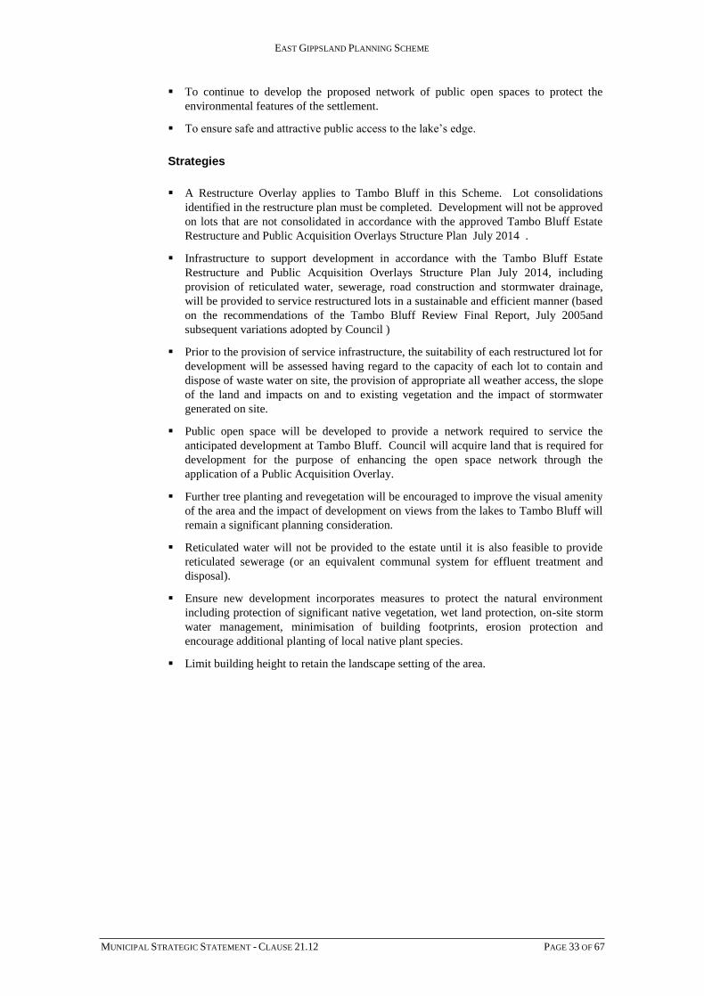
Lakes Entrance Strategy Plan
Strategy 3.2
Investigate and protect vegetated areas of significance, particularly in vulnerable
undeveloped areas within the town boundary. This should be undertaken prior to, or as part
of the approval of a subdivision.
Strategy 3.3
Ensure that a development plan is provided as a prerequisite before any development
occurs in the large rural holding north of Kalimna adjoining North Arm.
Strategy 3.4
Provide additional industrial land in Lakes Entrance, on land identified as being suitable in
the Industrial Land Study.
Strategy 3.5
Support the development of the land north of Lakes Entrance for rural living purposes in
line with the policy provisions contained in the Colquhoun Development Policy at Clause
22.15.
Strategy 3.6
Prepare a Development Plan for the landholdings within the Lakes Entrance Northern
Growth Area which is generally in accordance with outcomes sought by:
Lakes Entrance Northern Growth Area Outline Development Plan (October 2013)
Lakes Entrance Northern Growth Area Native Vegetation Precinct Plan(October,
2013);
Lakes Entrance Northern Growth Area Social Impact Assessment (August, 2012).
Strategy 3.7
Ensure that urban infrastructure, open space and community facilities required for
development of the Lakes Entrance Northern Growth Area is funded and delivered in
accordance with the Lakes Entrance Northern Growth Area Development Contributions
Plan (August, 2012) when subdividing any land included in the Outline Development Plan.

EAST GIPPSLAND PLANNING SCHEME
MUNICIPAL STRATEGIC STATEMENT - CLAUSE 21.12 PAGE 38 OF 67
Outline Development Plan
Urban Design
Objective 4
To improve pedestrian circulation and safety.
Strategy 4.1
Improve the town entry via the creation of a new gateway landscape, which will encourage
visitors to safely stop and view the Entrance and surrounding lakes and towns.
Strategy 4.2
Improve connections between the town centre and Kalimna residential area and within the
Kalimna area itself.
Strategy 4.3
Improve pedestrian connections across Princes Highway/The Esplanade between the
commercial edge and foreshore in particular adjacent to the Tourist Precinct and the
Civic/Village Precinct.

EAST GIPPSLAND PLANNING SCHEME
MUNICIPAL STRATEGIC STATEMENT - CLAUSE 21.12 PAGE 39 OF 67
Strategy 4.4
Improve pedestrian access and way finding throughout the retail centre, particularly to the
rear of The Esplanade in the vicinity of Church Street, and along the foreshore.
Strategy 4.5
Develop the connections between Lakes Entrance tourist precinct and Bullock Island.
Tourism
Objective 5
To promote recreational and tourism-focused uses within the town.
Strategy 5.1
Focus recreational and tourism uses within the Tourist Precinct and along the foreshore, in
particular opposite the Tourist Precinct and the Civic/Village Precinct
Strategy 5.2
Consider the use and development of the large rural holding north of Kalimna, adjoining
North Arm, either for a resort-style development or an integrated residential development
with recreational/tourist components.
Bullock Island
Objective 6
To redevelop Bullock Island to provide recreation and tourist facilities.
Strategy 6.1
Locate recreational and tourist opportunities in the western portion of Bullock Island.
Strategy 6.2
Encourage integration of Bullock Island into the town’s recreation/tourism attractions, in
particular those located within the Tourist Precinct, by providing improved connections
between the two nodes.
Strategy 6.3
Integrate Bullock Island into the town’s recreation/tourism attractions, in particular those
located within the Tourist Precinct, by providing improved connections between the two
nodes.
Implementation
The strategies in relation to Lakes Entrance will be implemented through the planning
scheme by:
Further Strategic Work - Lakes Entrance
If required, prepare a Schedule to the Bushfire Management Overlay where the
Bushfire Management Overlay applies to land within the Lakes Entrance Northern
Growth Area Outline Development Plan (October 2013)

EAST GIPPSLAND PLANNING SCHEME
MUNICIPAL STRATEGIC STATEMENT - CLAUSE 21.12 PAGE 40 OF 67
Reference Document
Lakes Entrance Northern Growth Area Social Impact Assessment (August, 2012);
Northern Growth Area Lakes Entrance Development Concept Plan Hydrology, Water
Technology October 2013)
Lakes Entrance Northern Growth Area Outline Development Plan (October 2013)
Coastal Towns Design Framework
Lakes Entrance Urban Design Framework
Application of zones and overlays
Applying the Design and Development Overlay to residential land to ensure new
development is in keeping with the existing character of Lakes Entrance.
Applying the Development Contributions Plan Overlay to land in the Lakes Entrance
Northern Growth Area to recoup infrastructure cost contributions.
Applying the Development Plan Overlay to land in the Lakes Entrance Northern Growth
Area to ensure that the area is developed in a well co-ordinated manner.
Applying the Vegetation Protection Overlay to roadsides in Lakes Entrance that have
significant vegetation but that have not been incorporated in the Native Vegetation Precinct
Plan.
Applying the Environmental Audit Overlay as a buffer around the Lakes Entrance Landfill.
Applying the Bushfire Management Overlay mapping and associated Schedule as required
to land contained with the Lakes Entrance Northern Growth Area".
Lakes Tyers Beach
Vision
Lake Tyers Beach will develop as an attractive coastal community with high environmental
values. The township will provide for permanent residents linked to the services available
in Lakes Entrance, but also retain its attraction for holiday makers.
The recreation focus of the township will remain on the lake and beach edge with improved
public facilities, better signage, effective stormwater management and enhanced car
parking and pedestrian circulation.
New development to the north of the township will be high quality, incorporate measures
to ensure water quality protection of Lake Tyers and reflect the lake edge/seaside character.
A neighbourhood service area in this locality will provide for residents daily needs.
A safe network of pedestrian trails will be available throughout the township and around
the foreshore perimeter.
Development will ensure the protection and conservation of the highly valued natural
resources of this area. Comprehensive revegetation of new development areas will be
undertaken to provide public pathways and wildlife corridors.
Objectives
To provide for additional residential development and accommodate population growth
in a coordinated and environmentally sustainable manner.
To improve the water quality of Lake Tyers.

EAST GIPPSLAND PLANNING SCHEME
MUNICIPAL STRATEGIC STATEMENT - CLAUSE 21.12 PAGE 41 OF 67
To expand opportunities for pedestrian movement and improve safety.
To protect and enhance the natural resource values of the town.
Strategies
Ensure that the development of Lake Tyers Beach occurs generally in accordance with
the Lake Tyers Strategy Plan.
Ensure that new development is of a high standard, complementary in character to the
existing town and environmentally sustainable through comprehensive design, siting
and development requirements.
Introduce stormwater management measures in existing and new development areas to
control sedimentation and nutrient inflow to Lake Tyers.
Ensure all new development is connected to reticulated sewerage and makes provision
for on-site stormwater management.
Improve access to the northern boat ramp with reduced impact on residential areas.
Incorporate expanded foreshore vegetation buffers and revegetation corridors in new
development areas.
Encourage consolidation within existing boundaries through infill development, prior to
allowing further expansion of the town.
Consider future tourist developments in residential zones, where appropriate.
Residential zones could also cater for local retail needs, for example, a neighbourhood
convenience goods store and/or take away food store, subject to demand and the need
for re-zoning.
Discourage further ribbon development along Lake Tyers Beach Road and other access
roads to the Lake.
Further Strategic Work – Lakes Tyers Beach
Investigate the potential for Farming Zone land to the north-west of the town to be
rezoned to allow future residential use incorporating extensive areas of public open
space.
Review the Master Plan in the Lake Tyers Beach Urban Design Framework.
Reference Documents
Coastal Towns Design Framework
Lake Tyers Urban Design Framework.

EAST GIPPSLAND PLANNING SCHEME
MUNICIPAL STRATEGIC STATEMENT - CLAUSE 21.12 PAGE 42 OF 67
Lake Tyers Beach Strategy Plan
Lake Tyers Aboriginal Trust
Lake Tyers Aboriginal Trust occupies a peninsula in Lake Tyers and is managed on a co-
operative basis by the Aboriginal community.
Major issues include the need to improve housing standards and the living environment for
the community. There are opportunities to extend reticulated urban services to the
community and improve the range of support services.
The settlement has features of great historic interest, including the church, and the potential
to become a major focus for indigenous cultural tourism, linked to the development of the
Bataluk Cultural Trail and other initiatives.
Council will support the existing roles and functions that the Lakes Tyers Aboriginal Trust
settlement fulfils and encourage development of new and enhanced roles as follows:
Town/Locality Support Existing Role(s) Encourage New/ Enhanced Roles
LAKE TYERS ABORIGINAL TRUST
Residential community
Cultural & recreational facilities
Historical significance
Opportunities for cultural and nature-based tourism
To achieve this, Council has prepared a Special Use zone for the Lake Tyers Aboriginal
Trust land.

EAST GIPPSLAND PLANNING SCHEME
MUNICIPAL STRATEGIC STATEMENT - CLAUSE 21.12 PAGE 43 OF 67
Nowa Nowa
Nowa Nowa has a population of approximately 200 and is a timber town and highway
service centre, with a growing focus on art and craft. It is located on the Princes Highway
between Lakes Entrance and Orbost.
Vic Roads is in the process of upgrading the route between Bairnsdale and Nowa Nowa via
Bruthen for a heavy vehicle alternative to the Princes Highway. This will involve
significant changes to the intersection between the Highway and the Buchan road in central
Nowa Nowa.
Council will support the existing roles and functions that Nowa Nowa fulfils and encourage
development of new and enhanced roles as follows:
Town/Locality Support Existing Role(s) Encourage New/ Enhanced Roles
NOWA NOWA
Population 1996 and 2011 (forecast) (172 -200)
Local retail & highway service centre
Significant timber industry location
Residential community
Community, and education facilities and services
Sporting and recreation facilities
Significant location for arts/ crafts
NRE office
Encourage value-adding in timber industry
Encourage streetscape improvements in township
Encourage role in arts-related and nature-based tourism
Encourage development and sign-posting of walking trails
To achieve this, Council will apply the following policies and strategies:
Nowa Nowa has been zoned Township, to retain flexibility in the distribution of uses.
However, retail and commercial activities will be encouraged to locate on the Princes
Highway and the Nowa Nowa-Bruthen Road, unless specific needs make another site
more appropriate.
Encourage value-adding in timber industry, on or adjacent to sites occupied by existing
timber enterprises.
Encourage development of tourist facilities, subject to appropriate servicing being
provided by the developer.
Encourage development and signage of a network of walking tracks linking the
township with natural and heritage attractions nearby.
Encourage streetscape improvements along the Princes Highway in the town.
Marlo
Vision
Marlo will develop as a village with excellent facilities and a lively community hub, while
retaining its character as a seaside holiday town looking out towards the river and ocean.
Marlo’s development will be contained to south of Healy’s Road and the town will look to
Orbost for higher order services.
Residential streets will be lined with trees and established gardens that reflect the coastal
character of the town.

EAST GIPPSLAND PLANNING SCHEME
MUNICIPAL STRATEGIC STATEMENT - CLAUSE 21.12 PAGE 44 OF 67
Facilities and shops will be easily reached by walking or cycling and opportunities for high
quality holiday accommodation will have been maximised in a way that is sensitive to the
environment, and brings benefits to the permanent residential community.
Objectives
To create an attractive town centre.
To improve pedestrian circulation and safety.
To enhance the town character.
To maintain the existing scale of residential development.
Strategies
Ensure that the development of Marlo occurs generally in accordance with the Marlo
Strategy Plan.
Contain low density residential to those areas proposed for that purpose on the Strategy
Plan.
Encourage new commercial uses to locate on Argyle Parade to consolidate commercial
enterprise.
Increase visual connections to the Snowy River and Bass Strait.
Provide natural environment and cultural heritage interpretation opportunities.
Establish connections to the foreshore south of Marine Parade.
Ensure the retention of significant trees in new development areas and require street
tree planting schemes as part of subdivision development approvals.
Protect the scale and character of the residential areas in the ‘old town’ area.
Ensure that the scale and character of development in Marine Parade is consistent with
the prevailing development form and height.
Further Strategic Work – Marlo
Investigate the potential for Farming Zone land to the east of Marlo Road and north of
Ward Street to allow for future residential use at slightly higher than existing densities
in order to contain the development of the town.
Consider Farming Zone areas to the west of Marlo Road for residential development
only when subdivision and development of the existing town and short term expansion
areas warrants further land supply.
Review the Master Plan in the Marlo Urban Design Framework.
Reference Documents
Coastal Towns Design Framework
Marlo Urban Design Framework.

EAST GIPPSLAND PLANNING SCHEME
MUNICIPAL STRATEGIC STATEMENT - CLAUSE 21.12 PAGE 45 OF 67
Marlo Strategy Plan
Bemm River
Vision
Bemm River will retain its character as a remote fishing hamlet, bordered by public Parks
and with excellent access to Sydenham Inlet.
It will have a range of recreational boating facilities and provide picnic areas and facilities
for holidaymakers.
Buildings will improve in quality over time, while still reflecting the ‘fishing village’
character of the hamlet.
The heart of the settlement, the foreshore, will be easily accessed on foot and will be
enhanced as a community hub.
Objectives
To protect the well-vegetated coastal hamlet character of Bemm River.
To ensure that fire protection is a key consideration in any further development.
To improve pedestrian access, circulation and safety.

EAST GIPPSLAND PLANNING SCHEME
MUNICIPAL STRATEGIC STATEMENT - CLAUSE 21.12 PAGE 46 OF 67
To improve the foreshore area and water access to both the coast and river.
Strategies
Ensure that the development of Bemm River occurs generally in accordance with the
Bemm River Strategy Plan.
Assess the suitability of land to the north of Kathleen Drive for limited residential
development incorporating appropriate on-site waste disposal arrangements.
Facilitate opportunities for improved pedestrian access to both the coast and river.
Further Strategic Work – Bemm River
Review the Master Plan in the Bemm River Urban Design Framework.
Reference Documents
Coastal Towns Design Framework
Bemm River Urban Design Framework.

EAST GIPPSLAND PLANNING SCHEME
MUNICIPAL STRATEGIC STATEMENT - CLAUSE 21.12 PAGE 47 OF 67
Bemm River Strategy Plan
Tamboon
The small settlements of Tamboon and Tamboon South are low-key holiday and fishing
retreats adjacent to Tamboon Inlet. There are also a few dwellings at Furnells Landing on
the Cann River. Tamboon South is surrounded by Croajingolong National Park and has no
road access.
Council will recognise the existing roles and functions that Tamboon and Tamboon South
fulfil.

EAST GIPPSLAND PLANNING SCHEME
MUNICIPAL STRATEGIC STATEMENT - CLAUSE 21.12 PAGE 48 OF 67
Town/Locality Support Existing Role(s) Encourage New/ Enhanced Roles
TAMBOON, TAMBOON SOUTH
Small holiday residential communities, limited access
The following policies and strategies will apply:
These settlements have been zoned Farming or Rural Conservation in the Planning
Scheme, to indicate that there is to be no intensification of development. New
dwellings within the settlements will be approved only if lots are capable of retaining
all wastes on site and development of more than one dwelling per lot will be strongly
discouraged.
No extension of settlements will be approved.
Mallacoota
Vision
Mallacoota will remain a peaceful town connected to the surrounding natural environment,
including the Inlet and National Parks.
It will have a lively, walkable commercial centre, linking activity to the foreshore and
wharf area. There will be sufficient community facilities for resident and visitor needs and
pedestrian and bicycle links will enhance access throughout the town.
Building design, materials and appropriate planting will reflect the coastal character of the
town’s setting. Mallacoota’s setting within a wilderness area will be recognised and the
town’s environmental tourism role will further develop in a sustainable manner.
Coastal related industries will be encouraged to support the town’s economy.
Objectives
To enhance Mallacoota’s role and character within a wilderness setting.
To create a cohesive and active town centre.
To improve pedestrian circulation and safety.
To improve the design and siting of buildings.
To protect and reinforce Mallacoota's aboriginal cultural heritage.
Strategies
Ensure that the development of Mallacoota occurs generally in accordance with the
Mallacoota Strategy Plan.
Increase visual connections to Mallacoota Inlet.
Provide natural environment and cultural heritage interpretation opportunities.
Enhance the town entry to incorporate an emphasis on environmental tourism.
Reinforce / establish activity nodes such as those outlined in the Foreshore
Management Plan (Wharf, Karbeethong, Bastion Point etc).
Encourage indigenous vegetation plantings in association with public and private
development.

EAST GIPPSLAND PLANNING SCHEME
MUNICIPAL STRATEGIC STATEMENT - CLAUSE 21.12 PAGE 49 OF 67
Contain Mallacoota’s development within existing zoned boundaries.
Encourage infill development of vacant sites along Maurice Avenue and Allan Drive,
while retaining links to the public open space precinct.
Preserve and enhance the village atmosphere of the town centre.
Encourage development of high quality tourist accommodation.
Consider the Mixed Use zoned area in Bastion Point Road (which contains several
depots/storage areas) for a wider range of uses, subject to their impact on residential
uses.
Further Strategic Work - Mallacoota
In the longer term, investigate the potential of the Farming Zone area north of
Karbeethong for longer term development subject to environmental evaluation.
Review the Master Plan in the Mallacoota Urban Design Framework.
Reference Documents
Coastal Towns Design Framework
Mallacoota Urban Design Framework.

EAST GIPPSLAND PLANNING SCHEME
MUNICIPAL STRATEGIC STATEMENT - CLAUSE 21.12 PAGE 50 OF 67
Mallacoota Strategy Plan
Gipsy Point
Vision
Gipsy Point will remain a small bushland retreat with a residential community as well as
some visitor accommodation.
The settlement will continue to be in harmony with the attractive natural setting of the
Croajingolong National Park and the tranquil waters of the Genoa River.
It will provide opportunities for both residents and visitors to enjoy the river and foreshore
and appropriate facilities are to be provided.
Little growth is anticipated, however any new development will respect the bushland
setting of the area.
Objectives
To improve the foreshore area and focal point of Gipsy Point.
To improve pedestrian circulation and safety.

EAST GIPPSLAND PLANNING SCHEME
MUNICIPAL STRATEGIC STATEMENT - CLAUSE 21.12 PAGE 51 OF 67
To ensure sound environmental management.
Strategies
Ensure that the development of Gipsy Point occurs generally in accordance with the
Gipsy Point Strategy Plan.
Rationalise the car park and improve access, while reducing the opportunity for
pedestrian / vehicle conflicts.
Ensure that all new development or redevelopment incorporates satisfactory on-site
waste disposal and water sensitive urban design techniques for storm water
management.
Ensure that new development or redevelopment provides for the retention of existing
native vegetation and incorporates replanting programs as appropriate.
Further Strategic Work – Gipsy Point
Review the Master Plan in the Gipsy Point Urban Design Framework.
Reference Documents
Coastal Towns Design Framework
Gipsy Point Urban Design Framework.
Gipsy Point Strategy Plan

EAST GIPPSLAND PLANNING SCHEME
MUNICIPAL STRATEGIC STATEMENT - CLAUSE 21.12 PAGE 52 OF 67
Genoa
Genoa is a small service centre on the Princes Highway, and serves as the eastern gateway
to East Gippsland Shire.
Council will support the existing roles and functions that Genoa and Gipsy Point fulfil and
encourage development of new and enhanced roles as follows:
Town/Locality Support Existing Role(s) Encourage New/ Enhanced Roles
GENOA Highway service centre and local retail
Focus for rural community
Community, recreation & sporting facilities
Develop potential as Eastern ‘Gateway’ to East Gippsland
To achieve this, Council will apply the following policies and strategies:
Genoa has been zoned Township zone, to provide a range of opportunities for
appropriate new enterprises.
Development of an Eastern Gateway information centre at Genoa will be encouraged.
In the rural area, retention of large lot sizes will be encouraged, but opportunities exist
for appropriate small scale tourist or commercial uses in association with rural
activities.
21.12-3 Agricultural Hinterland
The Agricultural Hinterland sub-region is described in Clause 21.02-3.
Opportunities for the Agricultural Hinterland sub-region include:
high value of agriculture land
vegetable growing
dairy farming
timber industry
tourism.
Constraints include:
flooding problems
high unemployment
long distance from main markets
declining population in some localities
decreasing industrial base such as timber industry
need to reduce fire risk
insufficient power supply (East of Orbost)
demand for rural residential development outside zoned areas.
Strategies for the Agricultural Hinterland sub-region are:
protecting high quality agricultural land
04/04/2013 C113

EAST GIPPSLAND PLANNING SCHEME
MUNICIPAL STRATEGIC STATEMENT - CLAUSE 21.12 PAGE 53 OF 67
protecting water quality and quantity, particularly in water catchments used for
domestic supply
preparing or upgrading flood and fire management strategies
providing opportunities to add value to both agricultural land and produce and timber
products
in the longer term, extending land capability studies in order to identify areas where
demand for rural residential style living can be met in a way that supports the local
economy and community, but reduces impacts on the environment and minimises
fragmentation of agricultural and pastoral land
providing assistance to regional towns to maintain their sustainability.
Rural localities in Bairnsdale district
The small rural settlements/localities of Fernbank, Clifton Creek, Woodglen, Flaggy Creek
and Bullumwaal each contain community or recreational facilities and provide a focus for
community activities.
Fernbank, an old Crown township, requires restructuring to reduce the potential
development density.
The Council will support the existing roles and functions that these places fulfils and
encourage development of new and enhanced roles as follows:
Town/Locality Support Existing Role(s) Encourage New/ Enhanced Roles
FERNBANK Former railway towns
Sporting facilities
Focus for rural community.
BENGWORDEN Focus for rural community
Recreation & sporting facilities
Potential location for major sporting facility
Potential for agricultural intensification.
CLIFTON CK,
WOODGLEN
Primary education centres for districts
Focus for rural communities
Recreation & sporting facilities
Encourage small scale tourist developments in rural areas.
FLAGGY CREEK Focus for rural community
Recreation & sporting facilities
BULLUMWAAL Focus for rural community
Recreation & sporting facilities
Fernbank has been zoned Low Density Residential and included under a Restructure
overlay.
Bullumwaal has been zoned Low Density Residential to reflect the current pattern of
development and ensure that lots are not subdivided below a size which is environmentally
capable of sustaining development.
Lindenow & district
Lindenow is a rural township located west of Bairnsdale, with an urban population of
around 300 and a district population of approximately 3000.

EAST GIPPSLAND PLANNING SCHEME
MUNICIPAL STRATEGIC STATEMENT - CLAUSE 21.12 PAGE 54 OF 67
The Lindenow district covers some of the most productive agricultural land in East
Gippsland and sustains a very diverse agricultural industry. Lindenow is recognised for
producing top quality vegetables for the local and national market as well as high grade
fine wool and dairy products.
Council will support the existing roles and functions that Lindenow fulfils and encourage
development of new and enhanced roles as follows:
Town/Locality Support Existing Role(s) Encourage New/ Enhanced Roles
LINDENOW/LINDENOW SOUTH
Population 1996 and 2011 (forecast) (236-275)
Local retail centre
Centre of vegetable industry in East Gippsland
Important dairying area
Significant residential community
Range of community & education facilities and services
Range of sporting and recreation facilities
Service industry to meet local needs
Appropriate location for vegetable processing industry and/or dairy products.
To achieve this, Council will apply the following policies and strategies:
High value agricultural land will be protected from inappropriate development. The
Mitchell River flats are zoned Farming, with a small minimum lot size for subdivision,
in order to facilitate restructuring of holdings for agricultural purposes. Development
of dwellings will generally require a permit, to minimise the impact of non-agricultural
uses on valuable land and the operations being carried out on it.
The floodplain of the Mitchell is covered by a Land Subject to Inundation overlay and
an Environmental Significance overlay recognising its value as high quality agricultural
land.
Consolidation of the town of Lindenow within existing boundaries will be encouraged,
using infill development. The current vacant sites should accommodate the anticipated
population growth for the next 15 years.
Bruthen
Bruthen township provides a basic level of services and facilities and is ideally located for
rural-residential living, being approximately 25 kilometres north-east of Bairnsdale and 30
kilometres north west of Lakes Entrance. The population of the Bruthen district is around
600 people.
The housing supply in the district has been increasing at approximately 10 dwellings per
year during the 1990s.
Bruthen was formerly the administrative centre of the Tambo Shire and a significant centre
for the timber industry. In the past ten years it has become a dormitory settlement for
Bairnsdale, as well as a focus for community services and recreation facilities for the
district. The highway service centre role of the town is likely to increase significantly with
the construction of the heavy vehicle alternative to the Princes Highway.
Mossiface and Sarsfield are small settlements near Bruthen, which contain a range of
facilities and points of interest, including the historic Mossiface Hop kilns.
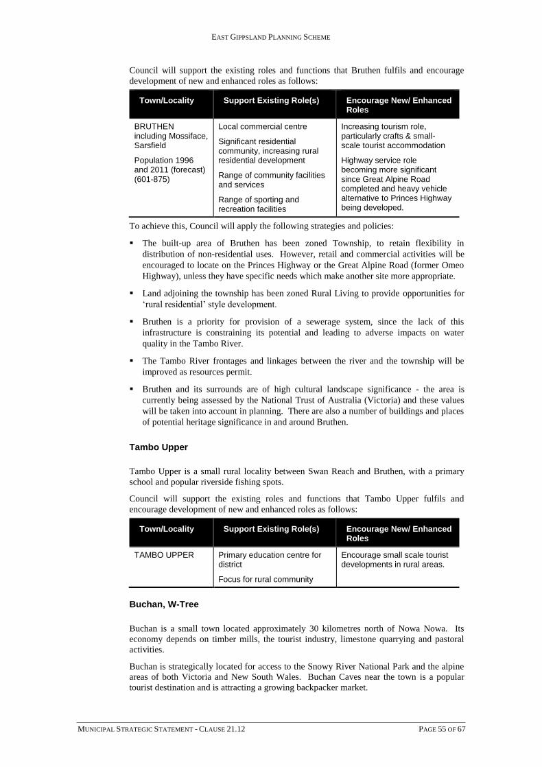
EAST GIPPSLAND PLANNING SCHEME
MUNICIPAL STRATEGIC STATEMENT - CLAUSE 21.12 PAGE 55 OF 67
Council will support the existing roles and functions that Bruthen fulfils and encourage
development of new and enhanced roles as follows:
Town/Locality Support Existing Role(s) Encourage New/ Enhanced Roles
BRUTHEN including Mossiface, Sarsfield
Population 1996 and 2011 (forecast) (601-875)
Local commercial centre
Significant residential community, increasing rural residential development
Range of community facilities and services
Range of sporting and recreation facilities
Increasing tourism role, particularly crafts & small-scale tourist accommodation
Highway service role becoming more significant since Great Alpine Road completed and heavy vehicle alternative to Princes Highway being developed.
To achieve this, Council will apply the following strategies and policies:
The built-up area of Bruthen has been zoned Township, to retain flexibility in
distribution of non-residential uses. However, retail and commercial activities will be
encouraged to locate on the Princes Highway or the Great Alpine Road (former Omeo
Highway), unless they have specific needs which make another site more appropriate.
Land adjoining the township has been zoned Rural Living to provide opportunities for
‘rural residential’ style development.
Bruthen is a priority for provision of a sewerage system, since the lack of this
infrastructure is constraining its potential and leading to adverse impacts on water
quality in the Tambo River.
The Tambo River frontages and linkages between the river and the township will be
improved as resources permit.
Bruthen and its surrounds are of high cultural landscape significance - the area is
currently being assessed by the National Trust of Australia (Victoria) and these values
will be taken into account in planning. There are also a number of buildings and places
of potential heritage significance in and around Bruthen.
Tambo Upper
Tambo Upper is a small rural locality between Swan Reach and Bruthen, with a primary
school and popular riverside fishing spots.
Council will support the existing roles and functions that Tambo Upper fulfils and
encourage development of new and enhanced roles as follows:
Town/Locality Support Existing Role(s) Encourage New/ Enhanced Roles
TAMBO UPPER Primary education centre for district
Focus for rural community
Encourage small scale tourist developments in rural areas.
Buchan, W-Tree
Buchan is a small town located approximately 30 kilometres north of Nowa Nowa. Its
economy depends on timber mills, the tourist industry, limestone quarrying and pastoral
activities.
Buchan is strategically located for access to the Snowy River National Park and the alpine
areas of both Victoria and New South Wales. Buchan Caves near the town is a popular
tourist destination and is attracting a growing backpacker market.

EAST GIPPSLAND PLANNING SCHEME
MUNICIPAL STRATEGIC STATEMENT - CLAUSE 21.12 PAGE 56 OF 67
The limestone, or ‘marble’ quarries near Buchan, which have supplied the stone for many
Melbourne landmarks, could be reopened to generate new employment and play a role in
tourist development.
Council will support the existing roles and functions that Buchan fulfils and encourage
development of new and enhanced roles as follows:
Town/Locality Support Existing Role(s) Encourage New/ Enhanced Roles
BUCHAN
Population 1996 (district) and 2011 (forecast) (400)
Local retail centre
Significant location for tourism, especially related to Buchan Caves & other ‘adventure’ activities
Significant timber industry location and centre for mining & quarrying
Significant residential community
Range of community, education & recreation facilities and services
Shire outreach centre
NRE/Parks Victoria office
Enhance tourism role in keeping with character of township & district
Enhance role as base for nature-based tourism
Encourage value-adding in timber industry
To achieve this, Council will apply the following policies and strategies:
The potential for retreat-style and nature-based tourism in the areas surrounding Buchan
will be recognised, together with opportunities for complementary commercial
development within the existing town boundaries.
Nature-based and adventure tourism will be encouraged, combined with increased
information highlighting the natural attributes of the area.
The visual amenity of the town will be preserved and upgraded.
Scenic roads and areas of high landscape significance will be protected.
Areas at W-Tree and Gelantipy were formerly zoned ‘Rural C’ under the Tambo
Planning to facilitate the development of co-operatives. No similar zone exists in the
Victoria Planning Provisions, so these areas have been zoned Farming. However,
subdivision of these properties will only be permitted if an appropriate standard of road
access and other services - including retention of treated sewage on-site - can be
provided to all new lots to be created.
Orbost
Orbost is a large rural service centre, with a population of 2,150, located on the Snowy
River. It provides a service, retail and administrative function for the surrounding rural
area.
In the last 15 years, population numbers in Orbost have declined, reflecting a downturn in
the timber industry and the effects of public sector restructuring. Nevertheless,
approximately 20 new dwellings per year were approved for Orbost in the first half of the
1990s.
Given the importance of Orbost as a service town for the vast rural area in the east,
stabilising the population size and revitalising the town centre is of strategic importance for
the eastern area. Orbost’s outlook is dependent on the future of value-adding to the
agricultural and timber industries, and on tourism. Great potential exists to promote the

EAST GIPPSLAND PLANNING SCHEME
MUNICIPAL STRATEGIC STATEMENT - CLAUSE 21.12 PAGE 57 OF 67
Snowy River as a major tourism icon and develop Orbost’s role (“the heart of Snowy River
Country”) as a centre for car touring and a gateway to the rivers and forests.
Council will support the existing roles and functions that Orbost fulfils and encourage
development of new and enhanced roles as follows:
Town/Locality Support Existing Role(s) Encourage New/ Enhanced Roles
ORBOST/ NEWMERELLA
Population 1996 and 2011 (forecast) (2,150)
Key ‘district’ centre for far East Gippsland
Centre of timber industry in far East Gippsland
Significant dairying & vegetable growing centre
Wide range of retail & commercial facilities
Shire business centre/ library
Very wide range of health & community services, reflecting isolation of areas served
Wide range of sporting & recreation facilities
Appropriate location for offices of Commonwealth & State agencies represented in Shire
Service industry to meet community needs
Promote Snowy River as a major tourist icon for East Gippsland
Appropriate location for major natural resource processing industry
Appropriate location for industries value-adding industries to primary produce of region
Hub for nature based tourism - coast, rivers, forests
To achieve this, Council will apply the following strategies and policies:
Consolidation of the town of Orbost within existing boundaries will be encouraged,
using infill development, prior to allowing further expansion of the town. The current
vacant sites should accommodate the anticipated population growth for the next 15
years.
In the longer term, if the demand for housing increases – particularly through
employment generated by value-adding in the timber industry or tourism – then
residential growth can be achieved by expansion of the town’s eastern boundary into
the currently vacant land located east of Arnold Street (see Orbost Strategy map).
However, development should not proceed on the land, until existing infill
opportunities are substantially taken up and reticulated sewerage and drainage services
are able to be connected the land.
Council will assist in identifying suitable sites for large scale industrial developments,
such as timber processing. Smaller industrial activities will be accommodated on
existing industrial zoned land, including the Rifle Range. Part of the area between
Martin Street and Bonang Highway, previously zoned industrial, has been changed to
Farming, since the slope and drainage are not suitable for industrial use.
For the retail/commercial area, a broad range of commercial and community facilities
and services will be encouraged in a pleasant, attractive environment that is compact
and accessible for residents.

EAST GIPPSLAND PLANNING SCHEME
MUNICIPAL STRATEGIC STATEMENT - CLAUSE 21.12 PAGE 58 OF 67
Orbost Strategy Map
Cabbage Tree Creek
Cabbage Tree Creek is a small settlement on the Princes Highway east of Orbost. It forms
one end of the tourist loop from Orbost to Marlo to Cape Conran and back to the Princes
Highway.

EAST GIPPSLAND PLANNING SCHEME
MUNICIPAL STRATEGIC STATEMENT - CLAUSE 21.12 PAGE 59 OF 67
Council will support the existing roles and functions that Cabbage Tree Creek fulfils and
encourage the development of new roles as follows:
Town/Locality Support Existing Role(s) Encourage New/ Enhanced Roles
CABBAGE TREE CREEK
Convenience retail for rural area
Highway service centre
Potential highway tourist location
Cabbage Tree Creek has been zoned Township in the Scheme.
Club Terrace
Club Terrace, off the Princes Highway between Orbost and Cann River, was formerly a
mill town, and is now a small residential community. There has recently been activity in
establishment of hardwood plantations on private land in the vicinity of Club Terrace.
Council will support the existing roles and functions that Club Terrace fulfils as follows:
Town/Locality Support Existing Role(s) Encourage New/ Enhanced Roles
CLUB TERRACE Residential locality
Club Terrace has been zoned Township in the Scheme
Cann River
Cann River is a timber and highway service town located at the intersection of the Princes
and Monaro (formerly Cann Valley) Highways, with a population of around 250.
Cann River provides for the convenience needs of the town’s residents as well tourist and
other highway users. The future development of the town will rely heavily on value adding
in the timber industry, but there is also potential to develop its role as an access gateway to
Croajingolong National Park.
The development potential of the township is limited by inadequate drainage and the
absence of reticulated sewerage.
Council will support the existing roles and functions that Cann River fulfils and encourage
development of new and enhanced roles as follows:
Town/Locality Support Existing Role(s) Encourage New/ Enhanced Roles
CANN RIVER
Population 1996 (est.) and 2011 (forecast) (246-300)
Local retail & highway service centre
Significant timber industry location
Access point for National Parks
Significant residential community
Range of community & recreation facilities and services
Secondary & TAFE education opportunities
NRE/Parks Victoria information centre/office
Appropriate location for new value-adding timber processing industry.
Enhance role as base for nature-based tourism.
Potential for small-scale value-adding to dairy produce.

EAST GIPPSLAND PLANNING SCHEME
MUNICIPAL STRATEGIC STATEMENT - CLAUSE 21.12 PAGE 60 OF 67
To achieve this, Council will apply the following policies and strategies:
Cann River has been zoned Township in the Planning Scheme to maintain flexibility in
the distribution of land uses. However, retail/ commercial development will be
encouraged to concentrate along the Princes and Monaro Highways, unless specific
needs make another site more appropriate.
Intensification of value-adding activities will be encouraged on the sawmill sites to the
east of the town, in preference to the low-lying area near the river (formerly zoned
Industrial). Land suitable for either residential or industrial expansion also exists to
north of the town, on the eastern side of the Monaro Highway. Demand does not
require this land to be given an urban zoning at this time.
Streetscape improvements will be encouraged in the main township area, in conjunction
with Vic Roads.
Noorinbee
Noorinbee is a small rural community north of Cann River, based around the primary
school and the recreation reserve.
Council will support the existing roles and functions that Noorinbee fulfils and encourage
development of new and enhanced roles as follows:
Town/Locality Support Existing Role(s) Encourage New/ Enhanced Roles
NOORINBEE Primary education centre for district
Focus for rural community
Recreation & sporting facilities
Encourage small scale tourist developments in rural areas.
Potential for small-scale value-adding to dairy produce
21.12-4 Highland
The Highland sub-region is described in Clause 21.02-3.
Opportunities include:
high environmental values offering a range of tourism opportunities
chance to capitalise additional tourist use of the Great Alpine Road and the Horsehair
Plain airport
good grazing lands
good highway access to the region
historically rich
proximity to forests for timber industry
valuable mineral deposits
lifestyle.
Constraints include:
isolation
lack of infrastructure
low employment base
adverse impacts of low commodity prices for livestock, wool and minerals
04/04/2013 C113

EAST GIPPSLAND PLANNING SCHEME
MUNICIPAL STRATEGIC STATEMENT - CLAUSE 21.12 PAGE 61 OF 67
need to reduce fire risk
steep terrain and soil characteristics can lead to erosion.
Strategies for the Highland sub-region:
protecting the unique natural and cultural environment of the sub-region
protecting water quality and quantity, particularly in water catchments used for
domestic supply
enhancing the tourism opportunities of the sub-region through nature-based tourism, its
rich cultural heritage and proximity to the snow field
exploring agricultural opportunities that may lead to improved economic viability
in the longer term, identifying areas where demand for rural residential style living can
be met in a way that supports the local economy and community, but reduces
environmental impacts and minimises fragmentation of agricultural land.
Freehold rural land in this region is the subject of a (1999) study investigating land
capability and environmental constraints, as well as identifying new land use options that
could provide a sustainable future for the area and its communities. Amendments to the
Planning Scheme may be necessary in future to reflect the outcomes of this study.
Glen Wills & Glen Valley
Glen Wills and Glen Valley are small rural localities to the north of Omeo. Glen Wills is a
former mining town, which requires restructuring of small allotments to allow development
for rural residential or holiday purposes.
Council will support the existing roles and functions that Glen Wills/Glen Valley fulfil as
follows:
Town/Locality Support Existing Role(s) Encourage New/ Enhanced Roles
GLEN WILLS, GLEN VALLEY
Historic mining centre
Residential locality
Small scale ‘retreat’ style tourist facilities
Crown Township to be restructured for low-density development.
Omeo
Omeo is service town in the Highland sub-region, with a population of 250. It provides
retail, administration, tourist services for a large rural area. The township has recently been
sewered and had its water supply upgraded. Rates of subdivision and development have
increased slightly in recent years.
Omeo is the only sub-alpine town in the Shire and, with the full sealing of the Great Alpine
Road over Mt Hotham, is in a position to benefit significantly from increased tourism
opportunities.
Traditionally, agriculture has been the main employment base of the district with high
quality cattle and sheep being produced. During the gold rush era of the 1850s the area
experienced a dramatic increase in activity that has left a colourful history, assisting in
developing today’s tourist industry.
Council will support the existing roles and functions that Omeo fulfils and encourage
development of new and enhanced roles as follows:

EAST GIPPSLAND PLANNING SCHEME
MUNICIPAL STRATEGIC STATEMENT - CLAUSE 21.12 PAGE 62 OF 67
Town/Locality Support Existing Role(s) Encourage New/ Enhanced Roles
OMEO
Population 1996 and 2011 (forecast) (298)
Significant ‘district’ centre for north-west part of East Gippsland (‘Omeo District’)
Centre for pastoral industry
Range of retail & commercial facilities & Government offices
Relatively wide range of health & community services, reflecting isolation of areas served
Shire Business Centre
Range of sporting & recreational facilities
Tourism, based on Great Alpine Rd, mining history, heritage character, and landscape and natural values of the area
Art/craft centre
Mining industry service centre
To achieve this, Council will apply the following strategies and policies:
Consolidation of the town of Omeo within existing boundaries will be encouraged,
using infill development, prior to allowing further expansion of the town.
Planning will attempt to capitalise on Omeo’s position as the “gateway” to the eastern
Victorian Alps and the Great Alpine Road.
Demands for development along the Great Alpine Road between Omeo and Dinner
Plain will be managed to provide a range of attractive environments for tourism or
permanent living, whilst preventing ribbon development and adverse effects on the
environment or landscape of the area.
Preservation and enhancement of the significant cultural heritage of the Omeo and its
environs will be encouraged through identification and documentation of heritage
places and application of appropriate planning controls.
Opportunities will be sought to improve linkages between the town and Livingstone
Creek.
Land use and development in the catchments of Lake Hume and Lake Dartmouth will
be managed to protect the quality of water flowing into these storages.
Benambra
Benambra is a small settlement north east of Omeo. It is a service centre for the area’s
main industries, grazing and mining.
Although the Benambra copper mine is not operational at present, it may open again if
world terms of trade for copper improve.
Council will support the existing roles and functions that Benambra fulfils and encourage
development of new and enhanced roles as follows:
Town/Locality Support Existing Role(s) Encourage New/ Enhanced Roles
BENAMBRA Local retail centre
Pastoral industry service role
Residential community
Range of community, education and recreation facilities
Could have enhanced tourism/ regional gateway role if road to Tom Groggin improved
Mining industry service role
Investigate potential for Lake Omeo to provide a water sports focus.

EAST GIPPSLAND PLANNING SCHEME
MUNICIPAL STRATEGIC STATEMENT - CLAUSE 21.12 PAGE 63 OF 67
Cassilis Valley
The Cassilis Valley is approximately 30 square kilometres in size and located north-west of
Swifts Creek. The area contains the remains of a number of former gold mining
settlements, and one mine is still operating.
Recent subdivision within the area has increased pressure on the environment of the valley.
Council will support the existing roles and functions that the Cassilis Valley fulfils and
encourage development of new and enhanced roles as follows:
Town/Locality Support Existing Role(s) Encourage New/ Enhanced Roles
CASSILIS Historic mining centre
Rural-residential locality
Limited local retail/ tourism role
Some potential for small-scale tourist development
Former Crown township to be restructured for low-density development
Potential for more intensive agricultural/ horticultural enterprises in appropriate areas
The following policies and strategies will apply:
Further investigation is required to determine the environmental/ land use capability of
the Cassilis Valley, but the area will generally be planned for relatively low density
rural development, including nature-based or rural-related tourism.
The old Crown townships of Cassilis and Tongio West will be restructured to
substantially reduce the potential development density.
Rural land in the remainder of the valley will be planned to ensure that potential
dwelling densities are substantially reduced from those that would exist if all Crown
allotments were allowed to be developed.
Swifts Creek
Swifts Creek is a rural town on the Omeo Highway just south of the Divide. It is the
location of a major timber mill (not operational in 1999) and of the district Secondary
College.
The Swifts Creek district population is estimated at 360. The numbers in the township
have declined slightly since 1981, but the surrounding rural population has increased.
Council will support the existing roles and functions that Swifts Creek fulfils and
encourage development of new and enhanced roles as follows:
Town/Locality Support Existing Role(s) Encourage New/ Enhanced Roles
SWIFTS CREEK
Population 1996 (est.) and 2011 (forecast) (250)
Local retail & commercial service centre
Historic mining industry centre
Significant timber industry location
Centre for pastoral industry
Range of retail & commercial facilities
Range of community, sporting
Tourism, based on Great Alpine Rd, mining history and opportunities for ‘farm stay’ and similar accommodation
Potential for value-adding to timber resources

EAST GIPPSLAND PLANNING SCHEME
MUNICIPAL STRATEGIC STATEMENT - CLAUSE 21.12 PAGE 64 OF 67
Town/Locality Support Existing Role(s) Encourage New/ Enhanced Roles
& recreational facilities
Secondary & TAFE education opportunities for ‘Omeo District’
Department of Sustainability and Environment office
To achieve this, Council will apply the following policies and strategies:
Swifts Creek has been zoned Township in this Scheme, although the boundaries of the
zone will require review when details of the areas affected by the June 1998 floods are
available.
Rural land will generally be planned to retain large parcels of land for pastoral uses, but
a range of small-scale tourist enterprises may be permitted in appropriate locations.
Reopening of the mill and development of further value-adding to timber products will
be encouraged, subject to maintenance of appropriate buffer distances for air and noise
emissions between the mill site and sensitive uses such as the schools and residences.
Ensay/Ensay South
Ensay and Ensay South are located south of Swifts Creek, providing services to the
surrounding district and to travellers. There is also a concentration of community service
facilities such as fire brigade and bush nursing centre.
Council will support the existing roles and functions which Ensay/Ensay South fulfil and
encourage development of new and enhanced roles as follows:
Town/Locality Support Existing Role(s) Encourage New/ Enhanced Roles
ENSAY/ENSAY SOUTH
Local retail/service centre
Residential community
Community & emergency facilities and services
Sporting and recreation facilities
Enhance tourism role, based on Great Alpine Rd and opportunities for ‘farm stay’ and similar accommodation.
21.12-5 Valleys & Forests
The Valleys & Forests sub-region is described in Clause 21.02-3.
Opportunities include:
increased tourism in particular that related to natural areas
development of plantations in appropriate locations
lifestyle
river fishing
out door activities.
Constraints include:
isolation and restricted access in some areas
poor communications
04/04/2013 C113

EAST GIPPSLAND PLANNING SCHEME
MUNICIPAL STRATEGIC STATEMENT - CLAUSE 21.12 PAGE 65 OF 67
problems with maintaining a sustainable population.
Strategies for the Valleys & Forests sub-region include:
ensuring a balanced approach to the protection of the natural environment and the
utilisation of timber resources
ensuring appropriate sites are available for nature-based tourism development to
complement opportunities in the parks
upgrading fire prevention and management strategies
exploring agricultural opportunities that may lead to improved economic viability.
Gelantipy/Suggan Buggan/Wulgulmerang
Gelantipy, Suggan Buggan and Wulgulmerang are rural localities located north of Buchan.
The area contains several large accommodation developments targeted at group or special
interest tourism.
The road linking these communities with Jindabyne in New South Wales is growing in
importance as a tourist route, particularly for back-packer tours, and provides access to the
middle reaches of the Snowy River.
Council will support the existing roles and functions that the localities north of Buchan
fulfil and encourage development of new and enhanced roles as follows:
Town/Locality Support Existing Role(s) Encourage New/ Enhanced Roles
GELANTIPY Primary education centre for district
Focus for rural communities
Tourist accommodation and convenience retail facilities
Recreation & sporting facilities
Encourage further nature-based tourist developments in rural areas.
SUGGAN BUGGAN Focus for rural community
Recreation & sporting facilities
Potential for tourist development if “Snowy River Road” upgraded.
WULGULMERANG
(SELDOM SEEN)
Convenience retail for rural area and tourists
To achieve this the ‘Snowy River Road’ and the Gelantipy-McKillops Bridge-Bonang
Road will both be recognised as routes of major scenic, tourist and historic value.
Improved maintenance and safety upgrades are required, but should be done sensitively, so
as not to detract from the values of these routes or to impact adversely on the environment.
Goongerah
Goongerah is a small settlement on the Bonang Road north of Orbost, which is serves the
surrounding rural community.
Council will support the existing roles and functions that Goongerah fulfils and encourage
development of new and enhanced roles as follows:
Town/Locality Support Existing Role(s) Encourage New/ Enhanced Roles
GOONGERAH Primary education centre for district
Encourage small scale tourist developments in rural areas.

EAST GIPPSLAND PLANNING SCHEME
MUNICIPAL STRATEGIC STATEMENT - CLAUSE 21.12 PAGE 66 OF 67
Town/Locality Support Existing Role(s) Encourage New/ Enhanced Roles
Focus for rural community
Recreation & sporting facilities
Tubbut, Bonang and Bendoc & surrounds
Deddick, Tubbut, Bonang, Delegate River and Bendoc are isolated small communities in
the far north-east of the Shire, reliant on the surrounding farming areas and, in the case of
Bendoc, on significant timber industries.
Department of Sustainability and Environment/Parks Victoria offices are located at Bendoc
and Tubbut. Large areas of State forest and National Park are readily accessed from this
area.
Council will support the existing roles and functions that these settlements fulfil and
encourage development of new and enhanced roles as follows:
Town/Locality Support Existing Role(s) Encourage New/ Enhanced Roles
TUBBUT Primary education centre for district
Focus for rural community
Recreation & sporting facilities
Encourage small scale tourist developments in rural areas.
DEDDICK Focus for rural community
Recreation & sporting facilities
Parks Victoria ranger station
BONANG Convenience retail for rural area
Community & recreation facilities
Develop potential as a base for nature-based tourism
Develop agricultural potential
DELEGATE RIVER Commercial/ entertainment facility for district
Tourist accommodation
Residential and rural community
Develop nature-based tourism potential
BENDOC Convenience retail
Significant timber industry location
Community & recreation facilities
TAFE/ community education opportunities
Department of Sustainability and Environment / Parks Vic office
Encourage value-adding in timber industry
Develop potential as a base for nature-based tourism
To achieve this, Council will apply the following policies and strategies:
To stabilise population, these localities will be encouraged to develop their potential for
nature-based tourism.
Encourage value-adding in timber industry, particularly at Bendoc.
Plantation development will be encouraged on appropriate sites which are consistent
with State policy and the Regional Vegetation Plan (when approved) where these do

EAST GIPPSLAND PLANNING SCHEME
MUNICIPAL STRATEGIC STATEMENT - CLAUSE 21.12 PAGE 67 OF 67
not impact adversely on the community or adjoining owners and where appropriate
road and bridge infrastructure can be guaranteed.
Potential for development of specialised pastoral or agricultural enterprises.
21.12-6 Old Crown townships (not listed above), including Bengworden, Hinnomunjie, Tongio Munjie, Waygara, Manorina, Tabbara
The following policies and strategies will apply:
These settlements have been zoned Farming or Rural Conservation in the Planning
Scheme, to indicate that they should continue to be used for broad area rural purposes.
No residential or other urban development will be approved unless specific studies find
the area to be suitable. Consolidation of lots may be required as a condition of any
permits granted.
04/04/2013 C113