Embed Size (px)
Citation preview

High resolution chemostratigraphy: a new method for geosteering in
clastic reservoirs at the wellsite: a case study of a recent well drilled
in the TAG-I reservoir in Algeria
Pearce, T.J., Martin, J., Chemostrat Ltd., Units 3-4, Llanfyllin Enterprise Park, Llanfyllin, Powys, SY22 5DD,
UK. Fernandez-Scougal, C., Halliburton, Howe Moss Drive, Kirkhill Industrial Estate, Dyce, Aberdeen, AB2 0GL
U.K. Aberdeen, AB2 0GL U.K. Lawton, D.E., BHP Billiton Petroleum Ltd., Neathouse Place, London, SW1V 1LH, UK.
Hughes, S., Halliburton, Howe Moss Drive, Kirkhill Industrial Estate, Dyce, Aberdeen, AB2 0GL U.K. Bessa, F., Sonatrach, Division Petroleum Engineering et Developpement, 8 Chemin du Réservoir, Hydra, Algiers
Triassic Argilo Gréseux-Inférieur (TAG-I) fluvio-
lacustrine sandstones of the Berkine Basin, in
Algeria, form a significant hydrocarbon reservoir.
The TAG-I sequences are of Middle to Late
Triassic age and unconformably overlie a Devonian
to Carboniferous subcrop and is in turn overlain by
claystones of the Triassic Carbonate, a shallow
marine claystone, limestone and evaporite
sequence. The TAG-I accumulated in a semi-arid
conditions in a fluvial system that occupied a NE-
SW trending valley system, formed in response to
syn-rift basin subsidence. The TAG-I sandstones
were deposited by braided and low to moderately
sinuosity fluvial channels (Figure 1), which are
concentrated into fluvial fairways separated by
floodplain fines with extensive palaeosol
developments.
Detailed reservoir-scale sandstone correlation is
hampered by marked vertical and lateral facies
variations, plus the sequences are
biostratigraphically barren. However,
chemostratigraphy has produced a four-fold
regional zonation for the TAG-I (Figure 2), with a
more detailed field-scale zonation (Martin et al.
2004) based on the analysis of over 500
conventional core samples. These zonations are
based on geochemical variations that reflect
changes in provenance and the depositional
environment (Ratcliffe et al. 2002) and this
corresponds well to the established TAG-I
Sequence Stratigraphy scheme of Turner et al,
2001.
Figure 1. Schematic TAG-I palaeo-environmental reconstruction

Figure 2. Chemostratigraphic zonation criteria used to establish a four fold reservoir of the TAG-I.
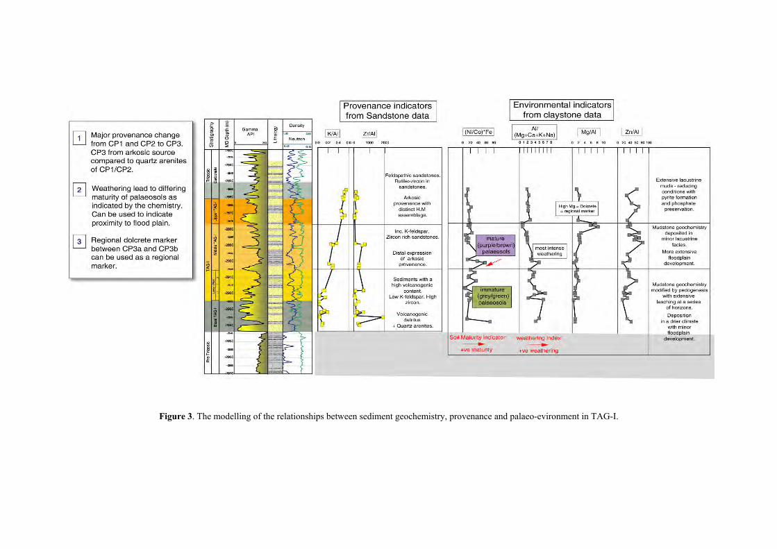
Figure 3. The modelling of the relationships between sediment geochemistry, provenance and palaeo-evironment in TAG-I.

During
Rhourde
real-tim
unde
spectrom
geoc
then
success
through
guidi
Uppe
traject
geom
and wat
sand
the drilling of a sinusoidal well on the
Oulad Djemaa (ROD) Field (Block 402),
e geochemical analyses of cuttings were
rtaken by laser-induced breakdown
etry (LaserStrat®). The resultant
hemical data and the field-scale zonation were
used together to modify and geosteer the well
fully along the optimum pathway down
the overlying Triassic Carbonate, then
ng the well bore through three passes of the
r and Middle TAG-I (Figure 4). This
ory then avoided the re-entry of the
echanically weak Triassic Carbonates (above)
er bearing/pressure separated Lower TAG-I
s (below), thus preventing additional well bore
stability problems and extra com
requirements.
The geochemical data (Al/(Ca+M
(Ni/Co)*Fe, Fe/Mg ratios) corro
sedimentological data have been use
palaeosol types and maturity, which resu
mapping of channel pathways and
floodplain fairways (Figure 5). Ke
geochemical parameters were also acq
time, potentially enabling wells to b
away from floodplain successions, that contained
few sandstones. High-resolution chemost
provides the framework for constrain
deployments and enables wells to be d
to their optimum field development prog
pletion
g+K+Na),
borated by
d to model
lted in the
mature
y palaeosol
uired real-
e geosteered
ratigraphy
ing wellsite
rilled closer
ramme.
Figure 4. rough the TAGI. The a.
The Chemostratigraphic zonation recognised during the drilling of the sinusoidal well thstratigraphic of reservoir was constrained using E-log and chemostratigraphic dat

Figure 5. The m g of sedimentological facies based on the geochemical data (from core and cutting and e
channel prone and floodplain fairways in the G
s samples) s dim ntologi al d ta enab in e iffe
TA -I.
e c a l g th d rentia n of tioodellin