Embed Size (px)
Citation preview

September 6, 2012
High Precision Urban and Indoor
Positioning for Public Safety NextNav LLC
© 2012 NextNav LLC

Mobile Wireless Location: A
Brief Background
• Mass-market wireless geolocation for wireless devices grew out of FCC requirements for E911
• The original Phase II wireless E911 location rules were conceived in 1996 and ultimately promulgated in 2001,
when cellphones were secondary communications devices
• In 2011, the FCC explicitly clarified that their location accuracy standards apply to outdoor calls
• The net effect of this on the wireless location ecosystem has been broad:
– Technologies that work reliably over large geographies tend to be optimized for outdoor positioning
– Technologies that work indoors tend to lack either reliability, coverage, performance or features
• This has affected the availability of services for other applications, such as out-of-vehicle officer location
September 5, 2012 | 2
Public Safety location has benefited from the mass-market created by
GPS-based consumer location (for outdoor location)
© 2012 NextNav LLC

E911 is Dominated by Wireless Users
• According to the FCC, 70% of 911 calls are placed from wireless phones with some jurisdictions reporting figures over 80%
• The most recent data from the Center for Disease Control’s wireless substitution survey indicate that 34% of U.S. homes have only cellular wireless telephones(1)
– Up from approximately 3% in 2003
– 56% of renters today are “wireless only” users
• An additional 16% of households are “wireless mostly” – using wireless devices for all or nearly all voice communications despite the presence of a land line
September 5, 2012 | 3
(1) http://www.cdc.gov/nchs/data/nhis/earlyrelease/wireless201206.pdf.
© 2012 NextNav LLC

Indoor E911 Process at the FCC
• The FCC has established CSRIC 3, Working Group 3 to examine and make recommendations
on indoor location accuracy standards
– Group includes regulatory, public safety and industry participation
• CSRIC3, WG3 has recommended to the FCC that it utilize the information gathered from a
“real world” test program to inform a future rule-making process to introduce indoor location
accuracy standards
– Currently scheduled to run in the San Francisco Bay Area through Q4, 2012
– Final report will be published in March, 2013
• Effect on ecosystem will be to bring reliable, accurate indoor wireless geolocation, suitable for
safety services, into the mass-market for the first time
September 5, 2012 | 4
Bay Area Test
Network
CSRIC Indoor
Location
Recommendations
and Final Report
Indoor Location
NPRM
Indoor Location
Report & Order
Q4 2012 March 2013 Expect 2013 TBD
Expected Indoor Location Accuracy Process
© 2012 NextNav LLC

Positioning Technology State of Affairs
The missing piece....
5m 50m 500m
Ou
tdo
ors
In
do
ors
Urb
an
Ca
nyo
n
Accuracy
Are
as
of
Use
A-GPS
A-GPS + AFLT
Cell-ID,
U-TDOA
Performance
Improvements
Needed for Public Safety
location:
• Indoor/Urban Canyon
High Precision
• Floor level Vertical
Accuracy
• Ubiquitous, reliable
availability
Wi-Fi
© 2012 NextNav LLC September 5, 2012 | 5

Location Techniques:
A-GPS
September 5, 2012 | 6
Signal Blocked,
No Height Information Open Sky, Good
Performance
Pros:
Highly synchronized
timing signals
Broad coverage
Very accurate in
open sky
Cons:
– Degraded indoors
and in urban areas
– Long TTFF
– Lower yield
– Inaccurate height
© 2012 NextNav LLC

Location Techniques:
U-TDOA and AFLT
September 5, 2012 | 7
Pros:
Service indoors and
in urban areas
Fast TTFF
More accurate than
Cell ID
Can be combined
with GPS in some
cases
Cons:
– Usually not accurate
enough for dispatch
– Often poor geometry
– Moderate
synchronization
– No height capability
U-TDOA
(Uplink Time
Difference of
Arrival)
AFLT
(Advanced
Forward Link
Trilateration)
O-TDOA in LTE will face similar limitations due to fundamental network
architecture and design principles
© 2012 NextNav LLC

Location Techniques:
WiFi / Short Range Beacons
• Popularized with the smartphone revolution in 2007 and the growing inclusion of WiFi and BlueTooth as secondary radios in advanced phones
September 5, 2012 | 8
Pros:
Service indoors and in
urban areas
Fast TTFF
Equipment cost typically
borne by 3rd parties
Good accuracy in dense
locations
Cons:
– Unmanaged
(uncontrollable), accuracy
limits
– No autonomous location
capability
– Accuracy degrades in low-
density areas
– Poor coverage, difficult to
scale
– No single party
responsible for multiple
essential system elements Acceptable for some consumer uses, WiFi has not been
seriously considered for public safety applications
© 2012 NextNav LLC

Location Techniques:
Inertial Sensors
• Smartphones typically contain multiple accelerometers, gyros and magnetometers for user interface and other applications
– Mass-market scale has significantly lowered the price of a full sensor
package
• With intelligent algorithms, “inertial” navigation capabilities are currently under development (none currently deployed)
– Operating principles differ from strap-down IMUs using traditional
inertial and multi-reference techniques
• Requires a known starting location from some other technology, and then degrades as drift sets in
– Calibration required, both on device and initial location level
– Indoors, no ability to initiate or correct via GPS
– Disruption of magnetic sensor performance in metal structures
– Drift a function of motion and time
September 5, 2012 | 9
Pros:
Autonomous tracking
capability
High precision over
limited time periods
Cons:
– Not a positioning
technology per se,
only measures offset
from a “known”
location
– Requires full sensor
package
– Sensor drift rates can
be very high relative
to required accuracy
– Predictability of
performance is
unknown (especially
with low cost, mass
market devices)
© 2012 NextNav LLC
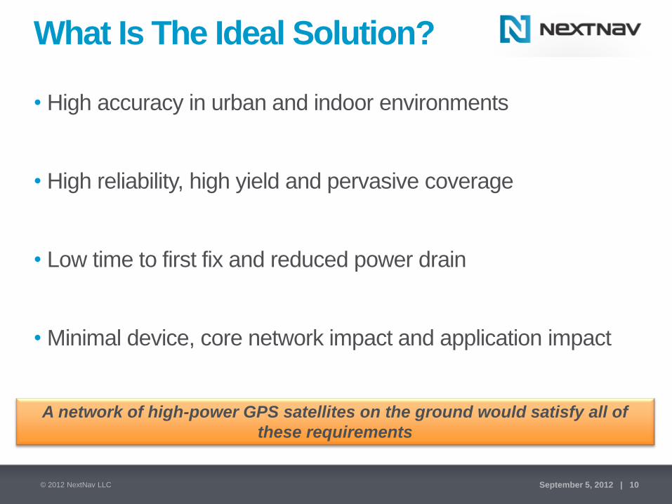
What Is The Ideal Solution?
• High accuracy in urban and indoor environments
• High reliability, high yield and pervasive coverage
• Low time to first fix and reduced power drain
• Minimal device, core network impact and application impact
A network of high-power GPS satellites on the ground would satisfy all of
these requirements
© 2012 NextNav LLC September 5, 2012 | 10

NextNav Metro Overlay Deployment
NextNav Beacon
NextNav Beacon
NextNav Beacon
Cell phone
In urban canyon
GPS Satellite
Blocked!
Location Network Element (SUPL, PDE, MPC)
Cell phone
Indoors
High Performance • Precise location in urban and indoor
environments
• Accurate vertical position (1-2m)
• Fast time to first fix (6 sec)
• Dependable “carrier-grade” performance
Wide Area Broadcast Network • Low-power, highly synchronized
• Encrypted signal
• Broad coverage from minimal sites
• No backhaul, small form factor
• Operate on licensed spectrum
Limited Receiver Impact • Firmware upgrade to “typical” GPS
chipsets
• Minimal handset integration cost
• On-device computation of location
• Reduced power consumption
Limited Core Network Impact • Utilizes existing PDE, SUPL elements
• Modifications to support NextNav information
• Similar to “Standalone GPS Mode” call flows
© 2012 NextNav LLC September 5, 2012 | 11

Fully Managed Location Network
• Approximately 93% POP coverage
• Spectrum designated for location services in
attractive 900 MHz band
Licensed Spectrum
• Every network element is owned, operated
and managed by NextNav
• Broadcast beacon locations selected to
optimize location precision
• Use of owned assets and licensed
spectrum ensures performance
• Accuracy and dependability suitable for
public safety applications
• Nationwide deployment underway
Managed Location Network
© 2012 NextNav LLC September 5, 2012 | 12

San Francisco Market Coverage
Coverage Key
Good Best
San Jose
Mountain View
Fremont
San Francisco Oakland
San Mateo
Cupertino
© 2012 NextNav LLC September 5, 2012 | 13

Reliable Indoor Accuracy
• Results across
suburban/urban
environment
‒ Offices
‒ Hotels
‒ Malls
‒ Homes
• Indoor results only
• ~100 locations and
5,000 data points
© 2012 NextNav LLC September 5, 2012 | 14

Depiction of Existing Outdoor E911
Rules (Handset-based)
© 2012 NextNav LLC September 5, 2012 | 15
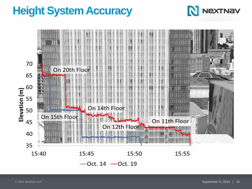
Height System Accuracy
16 © 2012 NextNav LLC September 5, 2012 | 16

Summary
• The location needs for E911 and public safety applications have outgrown previous “outdoor only” technologies as shown in the FirstNet SoR effort
• Public Safety can leverage the commercial “Mass Market” location trends to provide indoor high-precision and vertical location
• NextNav is deploying a “Carrier Grade” wide-area positioning system for US urban coverage to enable next generation location capabilities
– Addresses wide area needs of public safety location
– Commercial deployment and device developments enable cost effective derivative products and services for Public Safety
© 2012 NextNav LLC September 5, 2012 | 17