Embed Size (px)
Citation preview
AIR UNI V ERSITY
Higher Eyes in the Sky
The Feasibility of MovingAWACS and JSTARS Functions into Space
KIMBERLY M. CORCORAN, Major, USAF School of Advanced Airpower Studies
THESIS PRESENTED TO THE FACULTY OFTHE SCHOOL OF ADVANCED AIRPOWER STUDIES,
MAXWELL AIR FORCE BASE, ALABAMA, FOR COMPLETION OFGRADUATION REQUIREMENTS, ACADEMIC YEAR 1997–98.
Air University PressMaxwell Air Force Base, Alabama
October 1999

Disc laimer
Opinions, conclusions, and recommendations expressed or implied within are solely those of the author, and do not necessarily represent the views of Air University, the United States Air Force, the Department of Defense, or any other US government agency. Cleared for public release: distribution unlimited.
ii
Contents
Chapter Page
DISCLAIMER . . . . . . . . . . . . . . . . . . . . . . . . . . . . . . . . . . . . . . . ii
ABSTRACT . . . . . . . . . . . . . . . . . . . . . . . . . . . . . . . . . . . . . . . . . v
ABOUT THE AUTHOR . . . . . . . . . . . . . . . . . . . . . . . . . . . . . . . . . vii
1 INTRODUCTION . . . . . . . . . . . . . . . . . . . . . . . . . . . . . . . . . . . . . 1 Notes . . . . . . . . . . . . . . . . . . . . . . . . . . . . . . . . . . . . . . . . . . . 3
2 THE EVOLUTION OF MOVING TARGET INDICATOR RADAR SYSTEMS . . . . . . . . . . . . . . . . . . . . . . . . . . . . . . . . . . . . 5
Notes . . . . . . . . . . . . . . . . . . . . . . . . . . . . . . . . . . . . . . . . . . . 11
3 THE MECHANICS OF SPACE OPERATIONS . . . . . . . . . . . . . . . . . 13 Notes . . . . . . . . . . . . . . . . . . . . . . . . . . . . . . . . . . . . . . . . . . . 23
4 UNITED STATES SPACE ORGANIZATIONS THAT MAY AFFECT SPACE-BASED SURVEILLANCE SYSTEM DEVELOPMENT . . . . . . . . . . . . . . . . . . . . . . . . . . . . . . 27
Notes . . . . . . . . . . . . . . . . . . . . . . . . . . . . . . . . . . . . . . . . . . . 34
5 TECHNOLOGICAL DESCRIPTION OF CURRENT AIRBORNE MOVING TARGET INDICATOR SYSTEMS AND PROPOSED SPACE-BASED SYSTEMS . . . . . . . . . . . . . . . . . 35
Notes . . . . . . . . . . . . . . . . . . . . . . . . . . . . . . . . . . . . . . . . . . . 42
6 ISSUES TO CONSIDER FOR SPACE-BASED MOVING TARGET INDICATOR PLANNING . . . . . . . . . . . . . . . . . . . . . . . . . 45
Notes . . . . . . . . . . . . . . . . . . . . . . . . . . . . . . . . . . . . . . . . . . . 53
7 CONCLUSIONS . . . . . . . . . . . . . . . . . . . . . . . . . . . . . . . . . . . . . 55
Illustrations
Figure
1 Orbital Terms . . . . . . . . . . . . . . . . . . . . . . . . . . . . . . . . . . . . . . . 14
2 Geosynchronous Ground Tracks . . . . . . . . . . . . . . . . . . . . . . . . . 15
3 Satellite Ground Tracks . . . . . . . . . . . . . . . . . . . . . . . . . . . . . . . 16
4 Air Force Space Command Organization Chart . . . . . . . . . . . . . . . 28
iii

Abstract
During the past few years, United States Air Force (USAF) leaders have begun to emphasize space operations. Global Engagement: A Vision for the 21st Century Air Force states that we will eventually transition from an air and space force into a space and air force and various leaders have opined that that air and space are seamless. Gen Ronald R. Fogleman, USAF chief of staff, introduced the concept that in the future, we will be able to “find, fix, target, track, and engage (F2T2E)” any target, anywhere on the earth. In order to accomplish F2T2E, the functions performed by the E-3 airborne warning and control system (AWACS) and the E-8 joint surveillance, target attack radar system (JSTARS) will need to migrate to space-based platforms. This study explores how such a migration would occur.
Before examining space operations, the historical military need for moving tar-get indicators (MTI) is examined, tracing the evolution from hot air balloons to our current AWACS and JSTARS aircraft. Because space systems operate differently from airborne systems, those differences are explored. The organizations involved in space operations are also examined, along with their potential to effect the development of a space-based MTI system. The radar systems of both the AWACS and the JSTARS are described, as well as a few of the most prominent of the proposed space-based systems.
The planning for space-based MTI is in its early phases. A “Concept of Operations for Space-Based MTI” has been written, as has a “Space-Based MTI Roadmap.” US Space Command has also written the Long Range Plan, which includes space-based MTI concepts in its plan for 2020. These plans are a good start but do not address several important issues, including satellite architecture, whether satellite MTI systems should completely replace airborne systems, who should be responsible for the system, and how battle managers will operate in the new system.
v


About the Author
Maj Kimberly M. Corcoran was commissioned in 1982 through the United States Air Force Academy (USAFA), Colorado Springs, Colorado. After pilot training, she remained at Vance Air Force Base (AFB), Oklahoma, as a T-38 instructor pilot. In 1987 she became an action officer at Headquarters Air Training Command at Randolph AFB, Texas, where she continued to fly the T-38, in addition to her staff responsibilities. In 1989 she became involved with the acquisition of the Beechcraft T-1A Jayhawk and assisted in the development of its ground-based training system. In 1991 she was transferred to Reese AFB, Texas, as the deputy for analysis for the T-1A Operational Test and Evaluation Team. At the conclusion of testing, she joined the newly formed 52d Flying Training Squadron, becoming the flight commander for the first class of students graduating from specialized undergraduate pilot training. Later, she became squadron check/standardization and evaluation flight commander and finally an assistant operations officer. In 1994 she was transferred to Tinker AFB, Oklahoma, where she became an E-3 airborne warning and control system aircraft commander, flight commander, and instructor pilot. Major Corcoran is a senior pilot with more than 3,500 flying hours. She has a bachelor of science degree in engineering mechanics and in biological sciences from USAFA and a master of science degree in systems management from Saint Mary’s University. She is a distinguished graduate of Squadron Officer School and a graduate of Air Command and Staff College. In July 1998 she was assigned to J-33, the Joint Staff.
vii
Chapter 1
Introduction
We are now transitioning from an air force into an air and space force on an evolutionary path to a space and air force.
—Global Engagement: A Vision for the 21st Century Air Force
The statement above captures the United States Air Force’s (USAF) intention to lead the way in military space operations. As the USAF considers its future role in space, it has begun to explore the possibilities of migrating current airborne surveillance functions, such as those per-formed by the E-3 airborne warning and control system (AWACS) and the E-8 joint surveillance, target attack radar system (JSTARS), onto space-based platforms.
It is important to distinguish the difference between the words reconnaissance and surveillance that are often used synonymously. Reconnaissance is a snapshot of an area of interest. While it is extremely useful, it invariably represents an area as it was in the past, not necessarily as it is now. Traditionally, nearly all (noncommunications) space assets have performed reconnaissance. The most notable exception is the defense support program (DSP) satellites, which are used for missile warning. In contrast surveillance assets continuously monitor a given area and describe that area as it is in the present.1 Both AWACS and JSTARS are examples of current military surveillance platforms.
Space-based surveillance of surface and airborne targets appears to offer several advantages. Space platforms could potentially supply continuous coverage of nearly the entire globe, including many areas we cannot currently monitor using airborne systems, due to overflight restrictions. Because of their altitude, space systems are not subject to terrain masking like current systems. Satellites can also illuminate areas much farther behind enemy lines than airborne systems. JSTARS and AWACS can only peer a hundred miles or so behind enemy lines, whereas a satellite constellation would have no limits on how far behind enemy lines it could see. Another often-cited advantage of space assets is that they have the potential to reduce operations tempo because the personnel responsible for their operation could be stationed in the continental United States (CONUS), even during contingency operations.2 Even if it were necessary to station personnel overseas for a contingency, those personnel would perform their duties on the ground, rather than in the air, and would be well behind enemy lines.
Despite the potential advantages of space platforms, there are other areas where they appear less capable than airborne systems. Because
1

space-based systems are limited by orbital mechanics, their inability to loiter and maneuver means that significant numbers of satellites are required, even to assure coverage of small geographical areas. Additionally, once a satellite is launched, it becomes virtually inaccessible, which means it can only be repaired or upgraded at considerable expense, if at all. Satellites are also less able to perform ad hoc missions for which they were not originally designed. Another difference between airborne and space-based assets is that satellites have shorter life spans; surveillance aircraft have planned life spans of decades, while satellite life spans are currently around 10 years (though satellite life spans are on the increase). Satellite surveillance systems will also require significantly more power than airborne systems to illuminate targets because they are much farther away.
Despite these drawbacks, several factors are converging to make space surveillance of ground and airborne targets desirable. One factor is the growing importance of information on the modern battlefield. Joint Vision 2010, the “operationally based template for the evolution of the Armed Forces for a challenging and uncertain future,”3 identifies information superiority as the linking mechanism to the achievement of all other identified operational concepts (dominant maneuver, precision engagement, focused logistics, and full-dimensional protection). The USAF has refined the need for information superiority to include the ability to “find, fix, tar-get, track, and engage” any target anywhere on the planet. Space is the only vantage point from which that is possible.
Another factor driving the Air Force to consider space-based surveil-lance is the future viability of today’s airborne surveillance platforms. The AWACS aircraft are over 20 years old, have enjoyed a much higher operations rate than expected and contain outdated, and increasingly difficult to maintain, computer technology and radar electronics. Although the JSTARS computer and radar technology is quite modern, for economic reasons, refurbished Boeing 707s are being used for the air platform. These airframes, like the Boeing 707 airframes used by AWACS, will become increasingly expensive and difficult to maintain (due to shortages of spare parts) as we move into the twenty-first century. Both aircraft are currently scheduled to begin phasing out of service in the 2014 time frame and both will require considerable resources to keep them viable until that time.4 Replacing them with a fleet of new surveillance aircraft would cost considerably more. As the Air Force considers the factors that make our airborne assets increasingly expensive to operate, technology improvements on the horizon promise to reduce the costs of operating space systems, which have always been prohibitively expensive for all but the most critical national security tasks.
As more and more Air Force officers turn their attention to the concept of migrating airborne surveillance functions to space, the stove-piping of our officer corps becomes apparent. Officers familiar with flight operations understand little about space. Officers familiar with space opera-
2
tions understand little about flight operations and often fail to understand exactly what the various airborne support systems provide to the war fighter. This study attempts to bring the two sides closer together. Chapter 2 provides a brief history of the development and operational need for air-borne early warning systems. Chapter 3 provides those who are unfamiliar with space operations with a brief overview. Chapter 4 continues the space tutorial and examines the different organizations involved in our nation’s space program and considers how each may affect the development of a space-based surveillance system. Chapter 5 focuses on the technical challenges of migrating current surveillance functions into space by describing the systems currently used by the AWACS and JSTARS aircraft; it then provides a brief look at some of the space-based radar systems currently under consideration. Chapter 6 examines a number of issues that should be considered as the Air Force plans for space-based radar surveillance of surface and airborne targets.
Notes
1. James P. Marshall, Near-Real-Time Intelligence on the Tactical Battlefield (Maxwell Air Force Base [AFB], Ala.: Air University Press, 1994), 13.
2. Operations tempo (OPTEMPO) refers to the frequency that service members are assigned to duties away from their home station. The USAF goal is for personnel to be away from home no more than 120 days per year.
3. Chairman, Joint Chiefs of Staff, Joint Vision 2010 (Washington, D.C.: Pentagon, n.d.), ii.
4. David S. Pirolo and Ronald A. DeLap, “Space-Based Moving Target Indicator System Roadmap,” draft copy, 17 March 1998, 11.
3
Chapter 2
The Evolution of Moving Target Indicator Radar Systems
While the term moving target indicator (MTI) is new to the common military lexicon, the concept behind it is not. Armies have always needed to know the movements of their enemies. Scouts and commanders alike have used the highest ground available to observe the size, movements, and composition of enemy forces. This chapter explores the historical development of our current airborne MTI systems, the E-3 airborne warning and control system and the joint surveillance, target and attack radar system.
In 1794 the French became the first to use a new kind of high ground. During the Battle of Fleurus against the Austrians, men in tethered balloons provided information about Austrian troop movements to their ground commanders, using signal flags and messages sliding down a tether line via several metal rings.1 During the American Civil War, Union and Confederate armies also observed enemy troop movements using observers in tethered balloons. Thus, the use of airborne high ground began to prove its usefulness during military conflict.
As the value of airborne observation was realized, it became an element of military doctrine. In 1907 the US Army established an aeronautical division within the Signal Corps, which was to include both aircraft and balloons.2 In August 1909 the first aircraft was accepted into the Army inventory. In 1912 when the rating of military aviator was established, the Army had a total of 17 pilots.3 In 1914 the aircraft was mentioned in Army field regulations for the first time and formally assigned an observation role: “In forces of the strength of a division, or larger, the aero squadron will operate in advance of the independent cavalry in order to locate the enemy and keep track of his movements.”4
As an established element of doctrine, the use of aerial vehicles came into its own during the stalemated trench warfare of World War I. Balloons were used for frontline observation, while aircraft were flown deep into enemy territory to observe activities behind the lines. From their lofty vantage point, pilots and observers could see the buildup of munitions and reserves. The intelligence data they gathered enabled their side to counter enemy attempts to break through the lines. This contributed to the stale-mate and caused the development of fighter aircraft to prevent deep-look observations. By the end of the war, aircraft were performing all of the modern air missions: air control, force application, and force enhancement. In the process, balloons fell out of favor as the favorite observation platform, because they were too vulnerable to attack by aircraft. Additionally, the experiences of World War I highlighted the need for an
5

improved early warning ability so defending aircraft could be in the correct place to defeat incoming aircraft. As various theorists, like Giulio Douhet, considered the efficacy of strategic bombing, they asserted that the problem was so difficult that there was no defense against attacking aircraft.
Despite the difficulty, two defensive techniques were developed. One technique used extensively during World War I was the combat air patrol, also called the dawn patrol. In this system, defending aircraft would fly continuous patrols over friendly territory, visually watching for attacking aircraft. This method was extremely wasteful of their fragile resources, because the cloth-covered aircraft of the day did not last very long. Psychologically, it was crushingly boring to the pilots, which cut down on their sharpness. Finally, it was usually unsuccessful because it was impossible to defend everywhere all the time. Enemy aircraft were often able to sneak past these defenders. Another method of early warning was needed—some way to see the enemy coming far enough in advance that the defending aircraft could remain on the ground until needed and still have time to launch and climb to altitude.
The second defensive technique used during World War I was, in fact, such an early warning method. This method used ground observers to report incoming enemy aircraft. On the front lines, these observers were soldiers in towers or balloons scanning the skies with binoculars and reporting incoming aircraft via radio or telephone.5 Away from the front lines, the observers were on the ground and used telephones to report enemy aircraft to a central location. The majority of these ground observers were civilians. The biggest problem with this system was reliable communications. For example, in England, the telephone system was rapidly swamped by incoming calls from observers. By the time the English telephone network had been upgraded to carry the workload, the war was over.6
Between the wars, England and other countries continued to experiment with their observer corps. The English developed an effective system using inexpensive materials and mostly part-time observers under the command of a retired Royal Air Force senior officer. Observers called information to a central location, where personnel plotted the position of enemy aircraft using colored counters on a map grid. An overhead observer, called a teller, reported the tracks to air defence personnel.7 In the United States, tactical aviation advocate, Claire L. Chennault, demonstrated that a network of civilian observers, reporting by telephone, could provide enough information to enable fighters to intercept incoming bombers.8 Although ground observers were useful for monitoring the movements of enemy aircraft as they flew over land, a small island nation like England needed to be able to spot incoming aircraft well before they could actually be seen flying over the English countryside.
During the 1930s the necessary technology to see incoming aircraft from a distance was developed in England, Germany, and the United States. This technology is now called radar, an acronym for RAdio
6

Detection And Ranging. The United States and Germany both developed radar concepts as a method of ship detection. While both countries soon discovered that aircraft could also be detected, it was England that developed the operational concept of using radar as part of a comprehensive air defense structure.9
The British air defense system in place prior to the start of World War II added radar to their existing observation system and included all the elements required of today’s MTI system. Radar was used for long-range detection over the English Channel. Once detected, the flight paths of enemy aircraft were plotted and future locations were predicted. The system used a network of three types of radar: long-range radars, which could locate incoming aircraft more than 100 miles away; short-range radars, which specialized in locating low-flying aircraft at a range of about 25 miles; and mobile radar units, which could be used to fill the gaps created when enemy aircraft damaged any of the radar sites. Because the radars were designed to only look outward from the coast, the observer corps took responsibility for tracking aircraft once they crossed the coast. Information from both the radar stations and the observer corps were passed to centralized filter rooms where enemy locations were plotted onto a map. The plot was then passed to the operations room, which kept a complete record of the movements of all plots. This information was passed to the appropriate Fighter Command Group. Ground controlled intercept (GCI) controllers from each group then controlled the intercepts in their sectors.10 Friendly aircraft were differentiated from enemy aircraft by the use of a special radio transmission, so the two would not be con-fused. Good communications were essential between all parties: radar operators to plotters, plotters to GCI controllers, and GCI controllers to friendly aircraft. Overall, the British system, like any MTI system, included detection, identification, uninterrupted tracking and control, and robust communications.
The Allies for other missions besides air defense also employed radar. Ships were fitted with radar to help them find other ships. These had limited value, however, because radar’s ability to illuminate a target is limited to line of sight and both the receiver and the target were on the earth’s surface. Radars fitted on aircraft were more successful. In fact, airborne radar played a key role in the Allies’ success during the Battle of the Atlantic.11
Airborne radars were also used to locate enemy aircraft at night. In North Africa and in Europe, the Allies developed a comprehensive
radar system similar to the one used in England to assist their fighter operations. This system was the forerunner of today’s tactical air control system (TACS). A tactical control center, similar to today’s tactical air control center (TACC), was responsible for local fighter defense, “hostile warnings, control of aircraft for offensive missions, vectoring [aircraft] to primary and secondary targets, course changes to avoid interception and/or flak and ordering the missions to return to base should home base weather or ground conditions so dictate.”12 Tactical control centers were
7
located immediately adjacent to the ground commander’s combat operations center. They employed a powerful radar, called microwave early warning (MEW) units, to provide range, azimuth, and altitude on aircraft up to 200 miles away. Today those same functions are performed by a control and reporting center (CRC). The early system also had an equivalent of today’s control and reporting post (CRP), called forward director posts. These were placed in forward locations, and used less capable radars to illuminate areas not covered, due to obstructive terrain or long distances, by the MEW units.13
Unfortunately, this early TACS had to be reconstituted for Korea, because post–World War II demobilization efforts had included air defense and control systems. Like other organizations in the early parts of the Korean conflict, the TACS was a patchwork affair created from equipment and people gathered from around Japan and the Philippines. The 502d Tactical Control Group arrived from the United States three months after the war began, but they were unable to create an adequate air defense and control system until late 1952.14 The impetus for the continued improvement of this system was the sophisticated early warning and ground control radar (GCI) systems in use by the Chinese.15 Their GCI capability made it possible for the Chinese to employ the most effective air-to-air fighter tactic available: shoot down the enemy before he even knows you are there.
Although apparently not used for the war, sophisticated airborne early warning aircraft were developed and used in the early 1950s. After World War II, the US Navy explored several airborne radar systems, due to their concern about fleet defense. The most capable, the WV-1, was based on the Lockheed Constellation, one of the few aircraft large enough to carry a state-of-the-art radar. By 1951 the Air Force’s Air Defense Command (ADC) decided to purchase a large number of these aircraft, which were designated the EC-121 Warning Star.16 Like all airborne radars of the time, the radar in the EC-121 was most effective over water. It was less effective over the ground, because the ground’s irregular surface caused false returns on the radar scope, obscuring the controller’s ability to differentiate between airborne returns and “clutter.”17
Despite their problems with ground clutter, EC-121s saw considerable action in Southeast Asia because of their ability to extend radar coverage deep into North Vietnam. The air war over North Vietnam was similar to the air war over North Korea in that enemy aircraft enjoyed the full advantage of GCI radar, while the allies’ ground radar could not illuminate many of the areas their aircraft were bombing (due to terrain obstructions and long distances). In 1965 two F-105s were shot down by GCI controlled MiG-17s, who had evaded the F-100s flying combat air patrol.18 Shortly thereafter, ADC EC-121s were deployed to Vietnam under the code name Big Eye (changed to College Eye in 1967). Their purpose was to extend the existing TACS.19 Even though the radar was plagued by ground clutter in “look down” mode, this problem could be overcome to some extent by fly-
8
ing low and projecting the radar horizontally. Unfortunately, bad weather often made this solution untenable.20
Even with its limitations, the EC-121 proved useful for issuing MiG alerts, controlling intercepts, and warning pilots of possible border viola-tions.21 The EC-121 aircraft were able to be quite effective, despite their radar limitations, because they were equipped with an identification friend or foe/selective identification feature (IFF/SIF) interrogator system. The original version of this equipment was time consuming and difficult to use, but a new system was installed by 1968, which significantly improved mission effectiveness.22 Even more useful was the installation of an enemy IFF interrogator in the summer of 1967, which enabled the detection and positioning of enemy aircraft.23
Even before the EC-121 showed its capabilities and limitations in Southeast Asia, ADC officials had begun exploring the concept of a more capable airborne early warning platform. The concept of an airborne early warning and control system, or AWACS, first appeared in 1962, in response to the increased Soviet emphasis on their bomber fleet. Unfortunately, the conflict in Southeast Asia absorbed most of the avail-able resources and the concept was not developed.24 In 1969 the issue was raised again after a defecting MiG-17 flew undetected (by flying at 30 feet) from Cuba to Florida and two flights of Tu-95 bombers flew from Cuba to the Soviet Union, revealing that their unrefueled range put the United States at risk. ADC leaders also began to realize that their coastal defense system designed for high supersonic penetrations was no longer sufficient. At the same time, the EC-121, as an extension of the TACS, was proving the value of airborne warning and control platforms to Tactical Air Command (TAC). As a result, both ADC and TAC joined forces in 1967 to advocate procurement of a new AWACS.25
The result was the now familiar Boeing E-3 Sentry, commonly called the AWACS. The AWACS is a modified Boeing 707-320, with a Westinghouse Doppler radar and an IFF/SIF interrogator installed in a rotating rotodome above the fuselage. The E-3 has an unusually robust communications suite, which includes more than a dozen ultrahigh frequency (UHF) radios, two high frequency (HF) radios, and two satellite-communication radios. It usually carries more than 20 personnel. They are divided into four functional areas. First, flight operations personnel, who are responsible for flying the aircraft. Second, technicians, who operate, and, if necessary, conduct in-flight repairs of the radios, radar, and computer systems. Third, surveillance personnel, who detect and identify all traffic within radar range. Fourth, weapons controllers, who warn friendly air-craft about enemy aircraft identified by the surveillance section and direct friendly fighters to intercept them.
The weapons section is the heart of the AWACS mission. Their purpose is to greatly expand the situational awareness of friendly fighters, making them more effective and efficient, and, most importantly, ensuring their survival. As mentioned earlier, since World War I, the most effective way
9
to shoot down another aircraft has been to do so before the pilot is even aware of the threat. Preventing this threat to friendly aircraft that was TAC’s primary motivation for AWACS procurement; this is also the function (coupled with its high cost and limited numbers) that makes AWACS a national asset. In contingencies, such as the ones in Southwest Asia, fighter aircraft are not permitted to fly into potentially dangerous areas without the electronic vision of AWACS, keeping them safe from ambush.
Still, the AWACS fleet is aging; it is more than 20 years old and has seen far more action than originally anticipated: E-3 operations have been synonymous with high operations tempo almost since their inception in 1977. It needs upgrades to the airframe and all internal systems to extend its life and to continue to provide useful service, as both fighter and TACS technology evolves. In 1996 when Gen Ronald R. Fogleman, Air Force chief of staff, learned how much money it would take to upgrade the AWACS fleet, he asked if it were possible to migrate AWACS functions to space-based platforms. He inquired about migrating the functions per-formed by JSTARS to space, as well.26
The E-8 JSTARS is a surveillance platform similar to AWACS, except that its radar scans the ground, rather than the air. As the name suggests, the E-8 is a joint project between the Army and the Air Force. Both the Army and the Air Force were seeking a platform that could “identify, target and prepare to attack second echelon forces.”27 Second-echelon forces are about 150 miles from the forward line of own troops (FLOT) and may engage friendly ground forces within two to three days. Army doctrine emphasizes “preparation of the battlefield,” which is the plan for engaging those second-echelon forces after they move into position. In contrast, Air Force doctrine dictates the engagement of second-echelon forces before they have a chance to move into a position to engage friendly ground forces.28
Army corps commanders can task and receive data from JSTARS via a weapons system unique data link to a common ground station (CGS). The CGS is portable and can be carried on a five-ton truck or on a high-mobility multipurpose wheeled vehicle (HMMWV pronounced Humvee). An individual JSTARS can interface with more than 12 CGSs.29 While the JSTARS is the only sensor connected to the CGS, the CGS also receives data from numerous other Army intelligence sources and is seen as an essential element of the corps commander’s intelligence preparation of the battlefield.30
The JSTARS radar contributes to the commander’s preparation of the battlefield by providing two types of information: the location and movements of vehicles, and detailed maps. The moving target indicator mode can be directed to survey wide areas of several hundred kilometers or smaller selected areas (which can be defined by the operators). It is capable of distinguishing between wheeled and tracked vehicles, but is unable to identify the exact type of vehicle or distinguish between friendly and enemy vehicles. In synthetic aperture radar (SAR) mode, the radar can make detailed pictures of the ground “capable of discriminating specific
10
items such as vehicles, buildings and aircraft, but without highlighting moving targets.”31
Despite the different missions of the two aircraft, the crew complement of the JSTARS is very similar to that of the AWACS. The JSTARS typically carries 22 to 34 individuals, divided into the same four functional areas as AWACS (flight personnel, technicians, surveillance personnel, and weapons directors), plus an airborne intelligence officer or technician. While flight and weapons personnel are all Air Force members, the surveillance section includes Army personnel. Because of its intelligence mission, in JSTARS, both the surveillance and weapons sections are roughly equal in importance.
Although the JSTARS aircraft are so new to the inventory that their acquisition is incomplete, its functions are also candidates for migration to space for several reasons.32 The JSTARS was built on refurbished Boeing 707 airframes, which will drive up maintenance costs more quickly than if a newer airframe had been chosen. Additionally, instead of purchasing 30 or so aircraft (as with AWACS), only 13 aircraft will be purchased. This acquisition will limit its ability to support even one major military contingency, if the area of operations covers a wide front. Also, like AWACS, JSTARS can only see a limited distance behind front lines, whereas space-based radar would be able to see behind enemy lines with-out limitation.
Although space-based platforms may be capable of providing the same information as airborne platforms, they will operate differently. One difference is that the personnel responsible for executing the mission (surveillance and battle management) will be physically separate from the radar system, and will depend upon robust communication links between the platform and their operating location. In addition, despite frequent claims by Air Force leaders that air and space are seamless, the platforms that operate in the space must conform to different physical laws than those that operate in the atmosphere. The next chapter examines the fundamentals of orbital mechanics, the hazards of the space environment, and the challenge of space access, so that we can better understand how space-based surveillance will operate.
Notes
1. James P. Marshall, Near-Real-Time Intelligence on the Tactical Battlefield: The Requirement for a Combat Information System (Maxwell AFB, Ala.: Air University Press, 1994), 29.
2. Charles W. Reeves, “The History of Tactical Reconnaissance through 1941,” research paper (Maxwell AFB, Ala.: Air Command and Staff College [ACSC], 1967), 25.
3. Contrails 24 (Colorado Springs: USAF Academy, 1978), 19. 4. Quoted in Robert Frank Futrell, Ideas, Concepts, and Doctrine: vol. 1, Basic Thinking
in the United States Air Force 1907–1960 (Maxwell AFB, Ala.: Air University Press, 1989), 16.
11
5. Thomas H. Buchanan, The Tactical Air Control System: Its Evolution and Its Need for Battle Managers, College for Aerospace Doctrine, Research, and Education (CADRE) paper (Maxwell AFB, Ala.: Air University Press, 1987), 8.
6. Derek Wood, The Narrow Margin: The Battle of Britain and the Rise of Airpower, 1930–1940 (Washington, D.C.: Smithsonian Institution Press, 1990), 96.
7. Ibid. 8. Joe Gray Taylor, “Air Superiority in the Southwest Pacific,” in Case Studies in the
Achievement of Air Superiority, ed. Benjamin Franklin Cooling (Washington, D.C.: Center for Air Force History, 1991), 327.
9. Buchanan, 2–6. 10. Basil Collier, The Battle of Britain (New York: Macmillan, 1962), 50–53. 11. Richard Overy, Why the Allies Won (New York: W. W. Norton and Co., 1995), 38 and
50. 12. Buchanan, 14. 13. Ibid. 14. Ibid., 16; and Thomas C. Cone, “Korea,” in Case Studies in the Achievement of Air
Superiority, ed. Benjamin Franklin Cooling (Washington, D.C.: Center for Air Force History, 1991), 492.
15. Cone, 480. 16. Mike Hirst, Airborne Early Warning: Design, Development and Operations (London:
Osprey, 1983), 65–66. 17. Charles P. Crews, “An Improved Airborne Command and Control Capability for
Tactical Air Command,” research paper (Maxwell AFB, Ala.: ACSC, 1973), 35. 18. Robert Frank Futrell, Ideas, Concepts, and Doctrine: vol. 2, Basic Thinking in the
United States Air Force 1960–1984 (Maxwell AFB, Ala.: Air University Press, 1989), 289. 19. Contemporary Historical Evaluation of Combat Operations (CHECO) Division,
Tactical Evaluation Directorate, College Eye Special Report (Hickam AFB, Hawaii: Headquarters Pacific Air Forces), 10.
20. Crews, 37. 21. William M. Momyer, Air Power in Three Wars (Maxwell AFB, Ala.: Air University
Press, 1978), 151–52. 22. CHECO, 13. 23. Ibid., 16. 24. Robert H. Emmons, “An Analysis of AWACS,” research paper (Maxwell AFB, Ala.:
ACSC, 1971), 2. Document is now declassified. 25. Jack C. Miller II, “Evolution of the AWACS,” research paper (Maxwell AFB, Ala.:
ACSC, 1986), 2. Document is now declassified. 26. Pete Worden, deputy for Battlespace Dominance, Headquarters USAF/XORB, inter-
viewed by author, 17 March 1998. 27. Kenneth K. Young, “Operational Consideration of Joint STARS: Are We Missing the
Opportunity?” research paper (Newport, R.I.: Naval War College, 7 February 1997), 5. 28. Ibid. 29. Richard J. Yasky, “Changing the View of Operational Surveillance,” research paper
(Newport, R.I.: Naval War College 17 June 1994), 13. 30. Young, 5. 31. Douglas M. Carlson, “Joint STARS. Success in the Desert. What Next?” research
paper (Maxwell AFB, Ala.: Air War College, April 1992), 1. 32. Only three of the 13 JSTARS contracted have been delivered at this time.
12
Chapter 3
The Mechanics of Space Operations
The USAF is currently working to educate its members about the future capabilities of space operations. Unfortunately, displays and articles on this subject tend to concentrate only on the Air Force’s vision of future space operations, while largely ignoring current capabilities and failing to describe how space operations are accomplished. The latter is an important oversight. Most people have a general understanding of air operations due to their familiarity with airline operations and the frequent use of air operations as the setting for movies. The same cannot be said for space operations. Few outside the space community have any understanding of how space vehicles operate, and movies tend to perpetuate this ignorance. A basic understanding of space vehicles and their operation is a prerequisite to understanding how the migration of AWACS and JSTARS functions to space could occur.
Space vehicles differ considerably from air vehicles. First, the vast majority of space vehicles, those commonly called satellites, are unmanned. Second, because space is so remote, satellites are launched once and then rarely return to the surface in their original form. This important distinction limits satellites to the fuel and equipment on board at launch. Unlike air vehicles, few satellites can be refueled, repaired, or upgraded after launch.1 These limitations have a major impact on operations procedures and also limit the life span of a satellite. Unlike aircraft, which may have an upgradable design life of several decades, the majority of satellites are designed to last less than 10 years.
This chapter gives an overview of basic satellite operations, so that the reader can better understand the mechanics of space-based MTI. First, it provides a brief description of orbital mechanics. Second, it examines the three segments of satellite operations: the space segment, the control segment, and the user segment. Third, it describes the unique hazards of the space environment. Fourth, it examines the unique technical challenge facing all space-based systems: the lack of low-cost and routine access to space.
Satellite Orbits
Unlike air vehicles, space vehicles are not particularly maneuverable. Maneuverability of both types of vehicles is limited by available fuel. In aircraft the amount of fuel carried limits the vehicle’s range and endurance for a given sortie, but since air vehicles can return to the ground to refuel (or refuel in flight) considerable maneuvering or loitering is possible. Space vehicles, on the other hand, have only a finite amount of fuel, and that fuel is intended for maintaining the satellite in its
13
intended orbit. Generally, a space vehicle is limited to its original orbit for its entire lifetime. Fuel used for unplanned maneuvering, such as moving a satellite to provide better coverage of a contingency like Operation Desert Storm, significantly diminishes its overall life span.
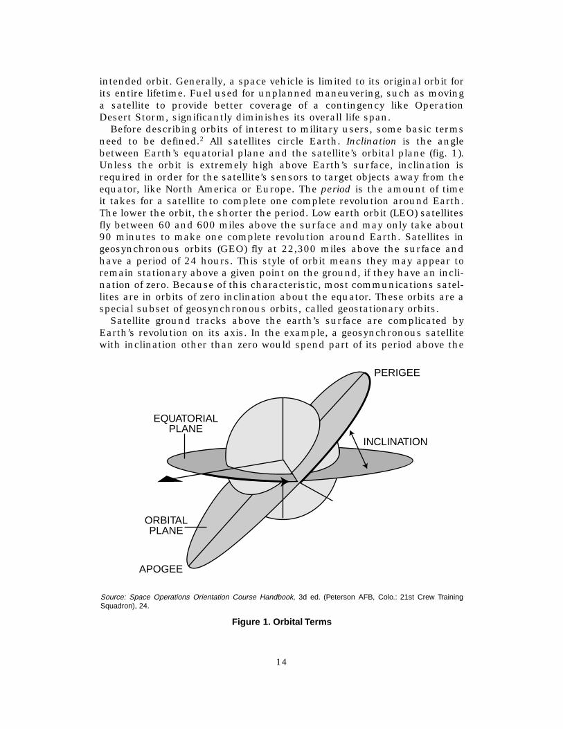
Before describing orbits of interest to military users, some basic terms need to be defined.2 All satellites circle Earth. Inclination is the angle between Earth’s equatorial plane and the satellite’s orbital plane (fig. 1). Unless the orbit is extremely high above Earth’s surface, inclination is required in order for the satellite’s sensors to target objects away from the equator, like North America or Europe. The period is the amount of time it takes for a satellite to complete one complete revolution around Earth. The lower the orbit, the shorter the period. Low earth orbit (LEO) satellites fly between 60 and 600 miles above the surface and may only take about 90 minutes to make one complete revolution around Earth. Satellites in geosynchronous orbits (GEO) fly at 22,300 miles above the surface and have a period of 24 hours. This style of orbit means they may appear to remain stationary above a given point on the ground, if they have an inclination of zero. Because of this characteristic, most communications satellites are in orbits of zero inclination about the equator. These orbits are a special subset of geosynchronous orbits, called geostationary orbits.
Satellite ground tracks above the earth’s surface are complicated by Earth’s revolution on its axis. In the example, a geosynchronous satellite with inclination other than zero would spend part of its period above the
EQUATORIAL PLANE
ORBITAL PLANE
APOGEE
PERIGEE
INCLINATION
Source: Space Operations Orientation Course Handbook, 3d ed. (Peterson AFB, Colo.: 21st Crew Training Squadron), 24.
Figure 1. Orbital Terms
14
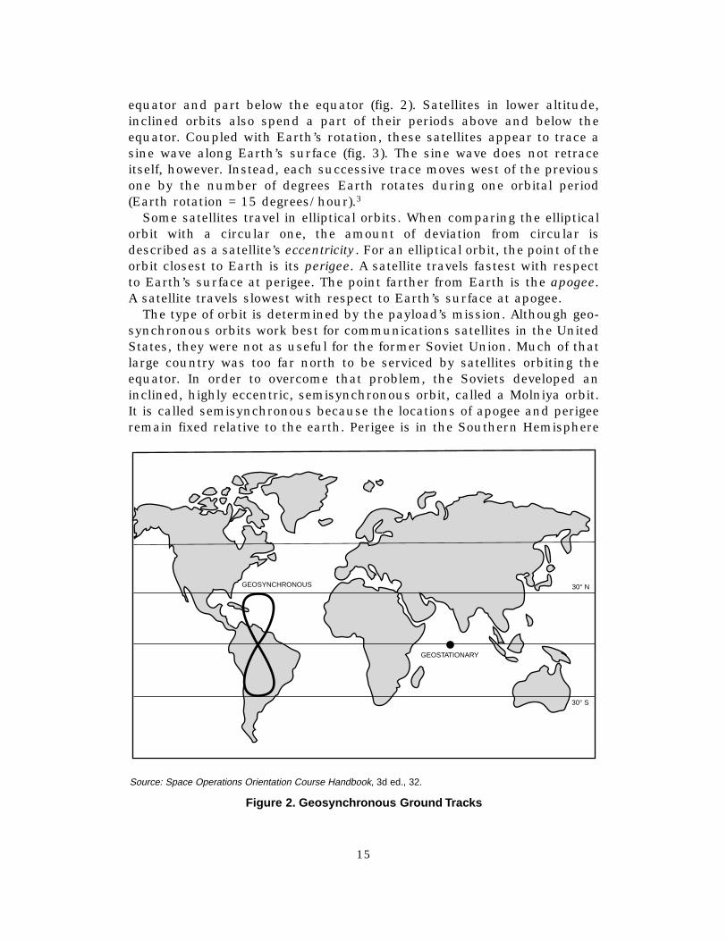
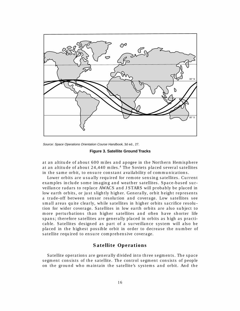
equator and part below the equator (fig. 2). Satellites in lower altitude, inclined orbits also spend a part of their periods above and below the equator. Coupled with Earth’s rotation, these satellites appear to trace a sine wave along Earth’s surface (fig. 3). The sine wave does not retrace itself, however. Instead, each successive trace moves west of the previous one by the number of degrees Earth rotates during one orbital period (Earth rotation = 15 degrees/hour).3
Some satellites travel in elliptical orbits. When comparing the elliptical orbit with a circular one, the amount of deviation from circular is described as a satellite’s eccentricity. For an elliptical orbit, the point of the orbit closest to Earth is its perigee. A satellite travels fastest with respect to Earth’s surface at perigee. The point farther from Earth is the apogee. A satellite travels slowest with respect to Earth’s surface at apogee.
The type of orbit is determined by the payload’s mission. Although geosynchronous orbits work best for communications satellites in the United States, they were not as useful for the former Soviet Union. Much of that large country was too far north to be serviced by satellites orbiting the equator. In order to overcome that problem, the Soviets developed an inclined, highly eccentric, semisynchronous orbit, called a Molniya orbit. It is called semisynchronous because the locations of apogee and perigee remain fixed relative to the earth. Perigee is in the Southern Hemisphere
GEOSYNCHRONOUS
GEOSTATIONARY
30° N
30° S
Source: Space Operations Orientation Course Handbook, 3d ed., 32.
Figure 2. Geosync hronous Gr ound Tracks
15
30° N
30° S
Source: Space Operations Orientation Course Handbook, 3d ed., 27.
Figure 3. Satellite Gr ound Tracks
at an altitude of about 600 miles and apogee in the Northern Hemisphere at an altitude of about 24,440 miles.4 The Soviets placed several satellites in the same orbit, to ensure constant availability of communications.
Lower orbits are usually required for remote sensing satellites. Current examples include some imaging and weather satellites. Space-based surveillance radars to replace AWACS and JSTARS will probably be placed in low earth orbits, or just slightly higher. Generally, orbit height represents a trade-off between sensor resolution and coverage. Low satellites see small areas quite clearly, while satellites in higher orbits sacrifice resolution for wider coverage. Satellites in low earth orbits are also subject to more perturbations than higher satellites and often have shorter life spans; therefore satellites are generally placed in orbits as high as practicable. Satellites designed as part of a surveillance system will also be placed in the highest possible orbit in order to decrease the number of satellite required to ensure comprehensive coverage.
Satellite Operations
Satellite operations are generally divided into three segments. The space segment consists of the satellite. The control segment consists of people on the ground who maintain the satellite’s systems and orbit. And the
16

user segment consists of the people on the ground who use the “output” of the satellite.
Most people are only aware of a small portion of the overall satellite, the payload. Payload is the term used for that portion of a satellite that per-forms the satellite’s purpose or mission. Current examples include the transponders in communications satellite or camera equipment in an imaging satellite. For a space-based MTI satellite, the payload would be the radar system. In addition to the payload, all satellites include several other subsystems. Subsystems common to all satellites include attitude control, thermal control, telemetry, tracking, and control (TT&C), and electrical power generation and storage.5 All of these subsystems are required to successfully operate the payload. Since satellites can rarely be repaired after launch, most subsystems include built-in redundancies.
Routine subsystem management is handled by the TT&C package. Interestingly, the TT&C subsystem gets its name not so much from the functions it performs, as from the monitored data it transfers to/from the control segment. This system transmits telemetry about the health of the satellite’s subsystems to the control segment on the ground and receives commands for each subsystem in return. Telemetry data includes temperature, pressure, currents, voltages, accelerometer readings, and the position of on/off switches.6
Attitude control subsystems are required to keep a satellite in the proper orbit, to provide precise satellite maneuvering when required, and to maintain the satellites in the proper orientation for the payload to per-form its mission. Station keeping refers to actions taken to overcome perturbations in a satellite’s orbit and is managed with thrusters. Attitude control is accomplished by one of three methods: spin stabilized (where the satellite spins), three axis stabilized (which uses gyroscopes), and zero-momentum stabilized (which uses a combination of spin and gyro-scopes).7 The importance of this function was highlighted on 19 May 1998 when the Galaxy IV communications satellite (in geosynchronous orbit just west of the Galápagos Islands experienced an attitude control failure and began an uncontrollable spin. As a result, 90 percent of the US paging network was knocked off-line, along with several television, radio, and wire service transmissions.8
Thermal control is important because satellites are exposed to extremes of heat and cold, depending on whether they are exposed to the sun or not. Temperatures may range from 150 degrees Celsius to –200 degrees Celsius. In addition, the vacuum of space makes heat dissipation, both from the sun and from internal electrical components, a challenge that must be carefully managed to keep equipment at acceptable operating temperatures.9 One method of controlling temperature is noncontinuous operation; the satellite only operates during a portion of its orbit and powers down for the remainder. This technique is not acceptable for communications or navigation satellites but is option for reconnaissance or surveillance satellites.
17
Power management is another challenge. Satellites are usually powered by solar panels. Because most satellites experience periodic solar eclipses, storage batteries are required. Anyone familiar with the operation of portable electrical equipment, such as video cameras or laptop computers, knows that careful management of battery charging and discharging cycles is essential to ensure long battery life.10
The payload also receives direction from the control segment via the telemetry tracking and commanding subsystem. Sensing satellites need to be told where and when to point their sensors and all satellites need to be told where and when to downlink their payload data. Note that information about the health and status of the satellite downlinked via the TT&C subsystem is generally referred to as telemetry, while information down-linked from the payload is called mission data and is not transmitted via the TT&C subsystem.11
The satellite’s TT&C subsystem downloads its telemetry and receives its commands from the control segment. The control segment performs four primary functions. In addition to the telemetry monitoring and command functions already addressed, the ground stations performing control functions also generate tracking data and conduct tests. Tracking data refers to measurements (range, range rate, azimuth, elevation angle, and time) used to determine a satellite’s precise orbital position. This information is compared to the desired orbit to determine if an adjustment command to the attitude control subsystem is required. Some satellites require extensive testing and calibration after launch. Testing may also be needed for troubleshooting specific problems and to gather information for design improvements.12
Each satellite requires frequent contact from the control segment in order to continue operating properly. For example, a recent Air Force Times article revealed that satellite operators from the 3d Space Operations Squadron contact each of 17 communications satellites three times a day. When a malfunction occurs, they call a satellite engineer who decides the commands required to correct the problem.13 Despite the remote location of satellites, their maintenance and operation is manpower intensive.
The ground stations that perform the control segment function come in several varieties. The number and locations of ground stations is dependent upon the satellite’s orbit. Satellites in geosynchronous or highly elliptical orbits require only one ground station. Satellites in low earth orbits may require several ground stations to ensure adequate control. When multiple ground stations are required, commands are usually generated at a central site and transmitted to remote sites, which then send the commands to the satellite(s). Remote sites may be manned or automated.14
There are many reasons for using a central site for command processing. The biggest reason is cost. Large computers and highly trained personnel are required to analyze the telemetry data from the satellite and to generate the proper commands to keep a satellite operating optimally. Ground stations communicate to satellites in a unique language and
18
satellites should only respond to uplinks that begin with a particular command sequence. Limiting the sources of command data limits the opportunity for errors, thus limiting the possibility that a satellite is commanded to do something harmful to it, like pointing its sensitive optical (payload) sensors into the sun. While the ground stations associated with the control segment may be physically colocated with the ground station of the user segment, it is important to understand that these segments do not share the same personnel, equipment, or facilities.15
The user segment is the most variable of the three segments, because its design is dependent on the satellite’s payload. Mission data may go to several users (even simultaneously) or to only one. For example, communication and navigation satellites release mission data to several users simultaneously. On the other hand, satellites that are used for remote sensing are more likely to require processing prior to release to end users and are often transmitted to a single processing center.16 Most reconnaissance satellites fall into this category. The user segment is the heart of satellite operations. The space segment and the control segment exist solely to support the user segment.
A space-based MTI system has the potential to increase the involvement of US Space Command (USSPACECOM) and Air Force Space Command (AFSPC) in user segment activities, which are currently dominated by the National Reconnaissance Office (NRO). Currently, the majority of AFSPC’s personnel (three out of four wings) are involved in either space launch or the control segment.17
Satellite Design Considerations
Space vehicles must be designed to overcome the special environment of space. Besides the lack of atmosphere and gravity, space vehicles are also subjected to temperature extremes, radiation, solar activity, and micrometeoroids. Some environmental characteristics affect the space vehicle’s operation, others disturb its orbit, and a few do both.
Environmental factors affect the operation of space vehicles in both predictable and unpredictable ways. Space is filled with radiation, much of it from the Sun. Some of this radiation becomes trapped by Earth’s magnetic field, in the area known as the Van Allen radiation belts. These belts consist of an inner area mileage that contains a majority of protons and an outer area that contains a majority of electrons. The Van Allen radiation belts do not effect satellites in low earth orbits, but satellites in highly elliptical or geosynchronous orbits must be designed to operate in this extensive radiation environment.18
Although the Sun is not the only source of radiation in space, it is the primary source in our solar system. This radiation becomes a particular problem during solar storms. These storms cause two primary problems for satellites. The first problem is the development of charge differentials on the satellite due to an increase in protons and electrons surrounding
19
Earth. Charge differentials occur when one area of the satellite becomes negatively charged and another area becomes positively charged or when the satellite develops a surface charge different from the charge of its surrounding environment. Although a charge differential can confuse certain sensors, the primary danger is the spark that occurs when the differential discharges. Even a small spark can cause false electronic switching, breakdown of thermal coatings, and degradation of amplifiers, solar cells, and optical sensors.19 The second problem associated with solar storms are called single-event upsets. These anomalies are totally unpredictable and occur when a single high-frequency particle penetrates a satellite. This penetration can cause a number of very serious problems ranging from data loss and software damage to computer failure and general satellite damage.20
The operation of communication satellites is particularly affected by solar phenomena. Solar flares and geomagnetic storms cause interference, due to solar radio noise, and phenomena called scintillation, which is a rapid change in the satellite communications signal strength and/or phase. Scintillation can cause data loss.21 Communication satellites are also inoperable (due to solar noise) for short times whenever they pass between the sun and their receiving station, but these outages seldom last more than a few minutes.22 These limitations must be considered when developing a space-based MTI architecture, because surveillance systems require uninterrupted data links to users, in order to be effective.
Micrometeorite strikes are another danger to satellite operation. Micrometeoroids are space debris and are usually made of rocky material, ranging in size from sand grains to boulders. Micrometeoroids may also be man-made, from the debris of earlier space vehicles. Although impact by a large meteoroid would be catastrophic, the vast majority of the objects are tiny, less than one millimeter. They are a threat because of their tremendous speeds, between 30,000 and 160,000 miles per hour.23
Micrometeorites can pit sensitive lenses, cause surface damage, damage solar panels, and, if they penetrate the satellite’s skin, damage or destroy electronic equipment. The numbers of micrometeorites varies from year to year. For example, in November of 1998 and 1999, Earth will pass through the Leonid meteor storm, which will cause the most severe meteor shower seen in 33 years.24 The extremely large antennas required by space-based radars (SBR) will be susceptible to micrometeorite damage and will need to be designed to withstand strikes.
Orbits are influenced by a number of environmental factors. Satellites orbiting at altitudes of 600 miles or less are effected by atmospheric drag, a phenomena that varies as the altitude of Earth’s atmosphere expands and contracts during solar storms. Orbits are also perturbed by the gravitational pull of the Sun and the Moon. Another source of orbital disturbance is the fact that Earth is not a perfect sphere: it has a bulge around the equator. Satellites in low earth orbits require constant orbital tweaking, because of Earth’s “waistline.”
20
The Launch Problem
A brief scan of recent speeches by various Air Force leaders shows that the limited availability of launch platforms is an on-going concern. In 1994 Lt Gen Thomas S. Moorman Jr., vice commander of AFSPC, bemoaned the time taken to launch heavy satellites (a minimum of 180 days), the exorbitant launch costs ($300 million for a Titan), and the nation’s loss of market share in the commercial launch sector (27 percent in 1993, down from 80 percent to 90 percent in 1973).25 Little has changed in the last four years. Gen Howell M. Estes III, the commander of USSPACECOM, has also emphasized the need for easy, inexpensive space lift in a number of his speeches, citing among other things the need to reduce the lift costs from around $4,000 per pound to hundreds of dollars per pound.26
The reason for this concern is easily understood. Access to space is an essential element for the Air Force as it transitions to a space and air force. Many of the systems the Air Force wants to employ, like MTI systems in particular, will require extensive constellations. Estimates of required constellation size for an MTI system range from 24 satellites to over 100. Add to the equation the relatively short satellite life span of 10 years and the need for robust launch capability becomes apparent, even if the satellites are small and several can be launched on a single booster. When one considers that the United States total launch counts over the past few years have been on the order of five heavy-lift launches, seven shuttle launches (which have not carried military payloads, since the Challenger accident), and about a dozen medium-lift launches, the need for improvement becomes even more obvious. For the past several years, many US companies have had to use the launch services of Europe, Russia, and China to meet their pace access requirements.
It takes a tremendous amount of energy to launch a payload into space. In “Ascendant Realms: Characteristics of Airpower and Space Power,” Maj Bruce M. DeBlois provides a useful analogy for the average airman.27
Using an F-16 as an example, he shows that it would take 40 times as much thrust to launch an F-16 sized vehicle into a low earth orbit as it takes to launch an F-16 into the atmosphere: approximately 1.15 million pounds of thrust versus 29,000 pounds of thrust. The thrust requirements to launch vehicles into space are so enormous that the effort is typically accomplished in two or three expendable “stages.”
The launchers used in the United States today all originated in the 1950s and early 1960s. These launchers come from three families of boosters: Atlas, first used as a space launch vehicle in 1958; Titan, established in 1955 as an intercontinental ballistic missile (ICBM) launcher; and Delta, first used as a space vehicle in 1960.28 These launchers have all been extensively modified over the years, but as W. Paul Blase noted in the March 1993 issue of Spaceflight: “This has resulted in a situation very much like trying to pull a semi-trailer with a racecar. Like a racecar, ICBM-
21

based rockets are designed to get maximum performance from minimum equipment. Technology is pushed to the brink to wring out that last ounce of thrust. However, it is an engineering truism that when one gets near the theoretical limits of a system, every additional 10 percent increase in performance doubles the systems cost and halves its reliability.”29
The maximum weight each booster can lift varies, depending upon the exact configuration of the rocket, the number and size of the satellite(s) carried, the type of orbit intended, and the launch site.30 Atlas rockets can lift a maximum of approximately 19,000 pounds into a low earth orbit, 9,000 pounds into a geosynchronous transfer orbit (an intermediate orbit from which the satellite will be transferred into a geosynchronous orbit),31
and 6,000 pounds into a geosynchronous orbit.32 Delta rockets can lift approximately 11,000 pounds into a low earth orbit, 4,000 pounds into a geosynchronous transfer orbit, and 2,000 pounds into a geosynchronous orbit.33 Titan rockets come in both medium- and heavy-lift varieties. The medium-lift Titan 3 can lift approximately 31,600 pounds into low earth orbit and 11,000 pounds into geosynchronous transfer orbit.34 The heavy-lift Titan 4 can lift up to 46,000 pounds into low earth orbit and up to 6,300 pounds into geosynchronous orbit.35
Currently, most launches are from Cape Canaveral, Florida, or Vandenberg AFB, California. A third launch site on Wallops Island, Virginia, is used for small launch vehicles. The sites at Cape Canaveral and Vandenberg AFB include both military and commercial launch facilities. Other commercial spaceports are under construction at Wallops Island and Kodiak Island, Alaska.36
The Air Force intends to reduce launch costs with the enhanced expendable launch vehicle (EELV). This program consolidates and standardizes the manufacturing, infrastructure, and operations of America’s standard launch vehicles and will eventually replace the current Atlas, Delta, and Titan medium- and heavy-lift launch systems. Between 2002 and 2020, the EELV program is expected to reduce space lift costs by 25–50 percent ($5–10 billion) over current systems costs.37 The medium-lift variant of the EELV is scheduled to be tested in 2001; the heavy-lift variant will first fly in 2003. The goal is for the EELV family of boosters to reach full capability by 2004.38 Despite the promised savings, as Maj William W. Bruner III notes in “National Security Implications of Inexpensive Space Access”: “it is impossible to get away from the fact that ‘staged expendable’ means, in effect, building two airplanes every time you fly, mating them meticulously, and sinking both craft in the ocean when the mission is complete.”39 These considerations have caused a number of commentators to advocate a reusable launch vehicle (RLV).
The concept of a reusable launch vehicle appears to offer many advantages. Besides the appeal of reducing costs by not tossing the fruits of our labor into the ocean after each launch, a reusable launch vehicle could also overcome some of the inherent limitations of space vehicles. Satellites could be constructed with the ability to be upgraded or repaired, either in
22
orbit using line replaceable units (LRU), or by bringing them back to the earth. The RLV concept proposes to increase launch responsiveness as compared to EELVs. A RLV could more readily respond to military contingencies by launching critical replacement satellites on demand. These advantages may all come to pass, but as Maj Michael A. Rampino notes in Concepts of Operations for a Reusable Launch Vehicle that the technology for this type of operation is not likely to be available until about 2012.40 USSPACECOM’s Long Range Plan also predicts that RLV technology will first become available in 2012.41 In addition to being responsive, a RLV must also be inexpensive to operate.
Because the concept of an inexpensive, responsive RLV is still unproven, the Air Force decided to continue with expendable launch vehicles as its primary space lift method, thus ensuring its access to space. Nevertheless, the Air Force was continuing to explore RLV concepts, until the president exercised the line-item veto eliminating the military space plane research and development program. This veto probably resulted from the second problem that consistently accompanies the concept of a reusable launch vehicle for the military: it has other applications besides space lift.
In addition to space lift, a reusable launch vehicle could be used for transspace transportation, reconnaissance or force application. Neither transspace transportation nor reconnaissance is controversial, but force application from space is extremely controversial. From the beginning of the space program, in the late 1950s, our political leaders have sought to avoid the employment of weapons in space. President Dwight D. Eisenhower insisted that space should be open to all countries and is used for peaceful purposes. His policies set the stage for the doctrine that space is a “sanctuary,” and led to the Nuclear Test-Ban Treaty in 1963 and the Treaty on the Principles of the Activity of States in the Exploration and Use of Outer Space in 1967. These treaties have guided our space policies by making political leaders sensitive to any project that could be interpreted as “weaponizing” space. Largely because of this sensitivity, National Aeronautics and Space Administration (NASA), a civilian organization, is leading government efforts for an RLV. These efforts are expected to result in the commercial development of an RLV.
This chapter has been a brief introduction to the unique characteristics of the space environment. Because space is very different from the atmosphere, a space-based MTI system will operate differently from our current systems. The following chapter examines the organizations that have the potential to effect the design and participate in the operation of a space surveillance system.
Notes
1. There are exceptions, such as the Hubble telescope, but these are extremely rare because the costs seldom justify the effort and risks. Launching the space shuttle, for example (our only current manned space platform) costs twice as much as launching a
23
satellite with an expendable launch vehicle because of the nature of the shuttle’s maintenance, launch, and recovery operations. The shuttle costs approximately $10,000/pound versus $5,000/pound for expendable launch vehicles.
2. Michael J. Muolo, Space Handbook, vol. 2, An Analyst’s Guide (Maxwell AFB, Ala.: AirUniversity Press, 1993). Only the terms that required understanding the fundamentals oforbital mechanics are addressed here. Muolo provides a detailed mathematical treatment.
3. Space Operations Orientation Course Handbook (SOOC), 3d ed. (Peterson AFB, Colo.:21st Crew Training Squadron), 27.
4. Roosevelt G. Lafontant, USMC, Spacecraft Survivability (Alexandria, Va.: DefenseTechnical Information Center, 1993), 19.
5. Bruno Pattan, Satellite Systems: Principles and Technologies (New York: Van NostrandReinhold, 1993), vi–vii.
6. SOOC, 108.7. Ibid., 112.8. Daniel Bases, “Satellite Fails; TV and Pager Services Hit,” Reuters News Service,
downloaded from America On-Line, 20 May 1998.9. Pattan, 191–96.10. Sue B. Carter, chief, Corporate Planning Division, Office of Plans and Analysis,
National Reconnaissance Office, interviewed by author, 26 March 1998.11. Sue B. Carter, “A Shot to the Space Brain,” research paper (Maxwell AFB, Ala.:
ACSC, 1997), 20.12. SOOC, 113.13. William Matthews, “A Down-to-Earth Force,” Air Force Times, 18 May 1998, 13.14. SOOC, 113–16.15. Carter, 20.16. Ibid., 24.17. Further details of the activities of various space organizations will be addressed in
chapter 4.18. Lafontant, 38–42.19. Muolo, 15.20. Ibid.21. Ibid.22. Andrew F. Inglis and Arch C. Luther, Satellite Technology: An Introduction (Boston:
Focal Press, 1997), 13.23. Bruce M. DeBlois, “Ascendant Realms: Characteristics of Airpower and Space
Power,” in The Paths of Heaven: The Evolution of Airpower Theory, ed. Phillip S. Meilinger(Maxwell AFB, Ala.: Air University Press, 1997), 552.
24. Jane E. Allen, “Meteor Storm Spurs Push to Protect Earth Satellites,” Air ForceTimes, 11 May 1998, 17.
25. Thomas S. Moorman Jr., “The Future of United States Air Force Space Operations,”Vital Speeches 60, no. 11 (15 March 1994): 325.
26. Howell M. Estes III, “Space as an Area of Vital National Interest,” speech to MILCOM’97, Hyatt Regency Hotel, Monterey, Calif., 3 November 1997; on-line, Internet, March1998, available from http://www.spacecom.af.mil.
27. DeBlois, 548.28. In addition, there are two boosters for small payloads: Pegasus, which is launched
from under a large aircraft, and can carry about 1,000 pounds into low earth orbit andTaurus, which is ground launched and can carry about 3,200 pounds into low earth orbit.
29. Quoted in William W. Bruner III, “National Security Implications of InexpensiveSpace Access” (unpublished School of Advanced Airpower Studies thesis, 1995), 15; on-line, Internet, available from www.au.af.mil/au/saas/studrsrch/bruner.doc.
30. The maximum payloads reported for each system varies from source to source,probably due to the wide variety of configurations available for each rocket.
31. Andrew Wilson, ed., Jane’s Space Directory 1996–1997 (Guildford, Great Britain:Biddles, 1996), 254–55.
32. “Atlas II,” Air Force Space Command Fact Sheet, March 1998; on-line, Internet, avail-able from www.usspacecom.af.mil.
33. “Delta II,” Air Force Space Command Fact Sheet, March 1998; on-line, Internet,available from www.usspacecom.af.mil.
34. Wilson, 249 (geosynchronous orbit payload not specified).
24

35. Ibid., 251. 36. Tamar A. Merhuron, “Space Almanac,” Air Force Magazine, August 1997, 38. 37. Howell M. Estes III, “Posture Statement for Senate Armed Services Committee
Hearings,” 11 and 12 March 1997; on-line, Internet, available from www.spacecom.af.mil. 38. “Evolved Expendable Launch Vehicle,” United States Air Force Fact Sheet, December
1996; on-line, Internet, available from www.spacecom.af.mil. 39. Bruner, 15. 40. Michael A. Rampino, Concept of Operations for a Reusable Launch Vehicle (Maxwell
AFB, Ala.: Air University Press, 1997), 46. 41. USSPACECOM, Long Range Plan, March 1998, 26.
25
Chapter 4
United States Space Organizations That May Affect Space-Based
Surveillance System Development
One of the interesting aspects of our nation’s development of space is that it has primarily occurred under the guidance of NASA, NRO, and the Department of Defense (DOD). Although USAF officers have been present in all three organizations from inception, these three organizations have remained completely independent from one another, largely because of the traditional high level of secrecy surrounding the NRO’s and the DOD’s space programs. In recent years, three things have driven the military and the NRO to cooperate with each other: the well-publicized success of space systems in the Persian Gulf War in 1991, the declassification of the existence and purpose of the NRO in 1993, and declining budgets. At the same time, DOD’s successful use of space assets during the Gulf War has caused the Air Force, in particular, to embrace the concept of increasing its involvement in space. As a result, space-oriented organizations have sprung up throughout the Air Force.
Despite today’s rhetoric, the Air Force’s current involvement in the user segment of space operations is somewhat limited. Other agencies have a much more robust interaction with the output from satellite payloads. NRO develops, controls, and uses a large number of “national assets” in orbit, including satellites for imagery intelligence (IMINT) and signals intelligence (SIGINT). NASA is also involved in space operations. In addition to the space shuttle, NASA develops, controls, and uses a number of satellites collecting data on space science and Earth observation. Another organization, the National Oceanic and Atmospheric Administration (NOAA) operates and uses mission data from several weather satellites in both geosynchronous and polar orbits.1 Finally, numerous private corporations operate and use imaging and communications satellites. This chapter describes the various organizations currently involved in military space operations and comment on the potential each has to help or hinder the creation of a concept of operations for the migration of airborne military surveillance functions to space.
United States Space Command
USSPACECOM is responsible for placing all DOD satellites into space, operating them, and providing support to the unified commands with satellite communications, navigation information—from the global positioning
27
system (GPS) NAVSTAR—and providing theater ballistic missile attack warning.2 USSPACECOM is also responsible for the nation’s ICBM fleet.
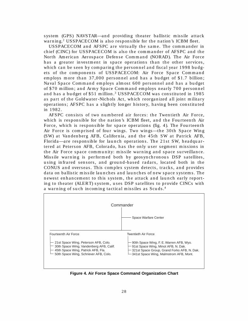
USSPACECOM and AFSPC are virtually the same. The commander in chief (CINC) for USSPACECOM is also the commander of AFSPC and the North American Aerospace Defense Command (NORAD). The Air Force has a greater investment in space operations than the other services, which can be seen by comparing the personnel and fiscal year 1998 budgets of the components of USSPACECOM: Air Force Space Command employs more than 37,000 personnel and has a budget of $1.7 billion; Naval Space Command employs almost 600 personnel and has a budget of $70 million; and Army Space Command employs nearly 700 personnel and has a budget of $51 million.3 USSPACECOM was constituted in 1985 as part of the Goldwater-Nichols Act, which reorganized all joint military operations; AFSPC has a slightly longer history, having been constituted in 1982.
AFSPC consists of two numbered air forces: the Twentieth Air Force, which is responsible for the nation’s ICBM fleet, and the Fourteenth Air Force, which is responsible for space operations (fig. 4). The Fourteenth Air Force is comprised of four wings. Two wings—the 30th Space Wing (SW) at Vandenberg AFB, California, and the 45th SW at Patrick AFB, Florida—are responsible for launch operations. The 21st SW, headquartered at Peterson AFB, Colorado, has the only user segment missions in the Air Force space community: missile warning and space surveillance. Missile warning is performed both by geosynchronous DSP satellites, using infrared sensors, and ground-based radars, located both in the CONUS and overseas. This complex system detects, tracks, and provides data on ballistic missile launches and launches of new space systems. The newest enhancement to this system, the attack and launch early reporting to theater (ALERT) system, uses DSP satellites to provide CINCs with a warning of such incoming tactical missiles as Scuds.4
Commander
Space Warfare Center
Fourteenth Air Force
21st Space Wing, Peterson AFB, Colo. 30th Space Wing, Vandenberg AFB, Calif. 45th Space Wing, Patrick AFB, Fla. 50th Space Wing, Schriever AFB, Colo.
Twentieth Air Force
90th Space Wing, F. E. Warren AFB, Wyo. 91st Space Wing, Minot AFB, N. Dak. 321st Space Group, Grand Forks AFB, N. Dak. 341st Space Wing, Malmstrom AFB, Mont.
Figure 4. Air For ce Space Command Or ganization Char t
28
Space surveillance is a counterpart to the missile-warning mission and involves the monitoring of all objects orbiting Earth. Air Force Space Command considers this mission to be the first step in accomplishing space control, the space version of the familiar air control mission (offensive and defensive counterair). At this point, AFSPC’s space control capabilities are limited to detecting, tracking, and cataloging the more than 8,000 man-made objects in orbit around Earth, ranging in size from a baseball to the Mir space station. Knowing the orbits of these objects is essential for collision avoidance during satellite launches and space shuttle missions.5
The 50th SW at Schriever AFB, Colorado, is the last space wing under the Fourteenth Air Force, and it has the most involvement with orbiting satellites. The six space operations squadrons in the 50th SW perform control segment functions for various military satellite systems. Besides controlling the DSP system, members of the 50th SW control the GPS, two communications systems (Milstar and defense satellite communications systems [DSCS]), and the defense meteorological satellite program (DMSP). In addition to control, 50th SW members test military and selected nonmilitary satellites immediately after launch and at their end-of-life disposal periods.
USSPACECOM was named the single focal point for military space operations in the unified command plan (UCP), the document delineating the responsibilities of the various joint commands. Based on this authority, the commander of USSPACECOM, General Estes, took a determined lead in the advocacy of offensive military space operations. His efforts resulted in a UCP change and more changes are predicted. Specifically he wants to make space a unified combatant command, just like US European Command (EUCOM) and US Central Command (CENTCOM).6 The object of General Estes’s effort is to weaken the decades old doctrine of space as a “sanctuary.” As he pointed out in testimony to the Senate Armed Services Committee, America’s reliance on space is such that it has become an economic and military center of gravity.7 As a center of gravity, space assets are subject to attack; therefore, it is incumbent upon USSPACECOM to make preparations to protect those assets with offensive systems as well as improvements to defensive systems.
Although USSPACECOM is concentrating its attention on enhancing its position with respect to space control and force application, it is also developing the concept of a space-based MTI system. Space-based MTI is mentioned briefly in USSPACECOM’s Vision for 2020, stating that “surface and air surveillance systems (e.g., AWACS and JSTARS) will be augmented by space-based surveillance systems.”8 Their Long Range Plan goes into more detail, identifying “integrated focused surveillance” as the corner-stone of Joint Vision 2010’s concept of global engagement. It notes that “the need for global surveillance (anytime, anywhere) leads to space-based solutions without political or geographical constraints. Over time many surveillance capabilities currently delivered by surface and air-based plat-
29
forms will migrate to space-based platforms.”9 Although surveillance for missile defense is emphasized, the migration of JSTARS and AWACS functions is specifically mentioned, as well.
USSPACECOM is laying the groundwork for space-based MTI with a number of internal documents. A “Concept of Operations for the Space-Based Moving Target Indicator (SBMTI) System” cowritten by USSPACECOM and Air Combat Command (ACC) was approved in February 1998.10
This document describes “what” an SBMTI system should do and also sketches broadly “how” it should work. USSPACECOM and the USAF Space and Missile Center (SMC) have also cowritten a “Space-Based Moving Target Indicator Roadmap.”11 This document describes the need for an SBMTI system, system architecture and implementation strategies, and implementation issues. Both of these documents are promising and will no doubt undergo several updates as the military comes closer to actually fielding an SBMTI system.
National Reconnaissance Office
The NRO was established in 1961 as an independent agency under DOD. The Undersecretary of the Air Force, Joseph Charnyk, was designated the director of the NRO (DNRO) in order to obscure the existence of the organization. Today, the DNRO remains dual hatted as the assistant secretary of the Air Force (Space), even though the NRO’s existence has been public since 1993. The NRO was conceived as a joint intelligence venture between the Air Force and the Central Intelligence Agency (CIA). Its mission was to develop and manage the early US satellite reconnaissance effort. The Eisenhower administration desperately needed these intelligence-gathering assets to fight the cold war. During the next 30 years, the NRO “was America’s ‘eyes and ears’ into the denied areas of the Soviet Union, providing intelligence and warning on their war-making capabilities, tracking weapon and missile developments, military operations, order of battle, nuclear capabilities, and both industrial and agricultural production.”12 The NRO’s emphasis was on reconnaissance, rather than surveillance, and its primary customer was the president of the United States and the National Command Authorities.
The declassification of NRO in 1993 had far-reaching effects for the organization. Since that time, it has been in a mild state of flux, as its director contends with the realities of competing with other DOD organizations (under the same public and military scrutiny) over its budget. The need to compete for funds has caused it to refocus its mission to include support to the war fighter, while continuing to support the intelligence community. While still an extremely secretive and security conscious organization, many of the barriers previously formed by the highly compartmented classification of various programs are coming down, as the NRO seeks to maximize its usefulness to both communities by fusing information from its various systems and programs.
30
As the NRO has moved into the public arena, it has begun to ally itself with other space organizations, especially USSPACECOM. The increasing cooperation between the two organizations was noted by both General Estes and Keith R. Hall, DNRO, during their testimony before the Senate Armed Services Committee Strategic Force Subcommittee.13 This cooperation has already benefited the migration of MTI to space-based platforms through a memorandum of agreement (MOA) for the Space-based Radar Risk Reduction and Demonstration Program, the development and deployment authorization for the Discover II program.
Discover II is a combination ground MTI and synthetic aperture radar, like JSTARS. The project is being jointly developed and funded by the USAF, the NRO, and the Defense Advanced Research Projects Agency (DARPA). The NRO did not willingly volunteer to support the Discover II project: it was forced to participate by Congress, who was influenced by DARPA. Additionally, the Defense Science Board Task Force on Satellite Reconnaissance has suggested that the NRO’s planned Future Imagery Architecture could be jeopardized by its participation in the Discover II project. The board is concerned that the NRO will become the primary bill payer for a follow-on operational radar surveillance constellation.14
Realistically, space-based surveillance of moving targets is unlike traditional NRO operations. The NRO has always concentrated on national strategic missions. Data from these “national” assets may also have operational or tactical-level military applications, which is why the NRO is attempting to add the war fighter as a customer. Surveillance of moving targets, however, has traditionally been a military function in direct sup-port of a theater commander. As such, it makes sense that the military should pursue SBMTI, not the NRO. At the same time, the NRO should stay engaged because of the possibility that the overall concept of operations (CONOPS) will include fusing information from NRO assets for identification purposes, especially for air MTI (AMTI). However, the Office of the NRO should not be responsible for implementation and operation of an SBMTI system.
Defense Advanced Research Projects Agency
DARPA was established by President Eisenhower in 1958, immediately after the Soviet Union launched sputnik.15 DARPA’s mission is “to assure that the U.S. maintains a lead in applying state-of-the-art technology for military capabilities and to prevent technological surprise from her adversaries. . . . DARPA was designed to be an anathema to the conventional military and R&D structure and, in fact, to be a deliberate counterpoint to traditional thinking and approaches.”16 One reason for DARPA’s establishment was to ensure that nothing like sputnik would recur. By creating an organization that would be free from the service’s political and fiscal restraints, the administration believed DARPA would be able to “think outside the box.”
31
DARPA is the third signatory (with the USAF and the NRO) for the MOA for the Space-Based Radar Risk Reduction and Demonstration Program, and was, in fact, the primary driver behind the program.17 Unlike the USAF and the NRO, DARPA already has a mature vision of what the Discover II program will accomplish. Under the circumstances, DARPA’s vision will probably become reality, and, if the demonstration is successful, the Discover II design is likely to be used in the operational constellation.
Other DOD Space Organizations
As space has garnered increased attention, a number of new agencies have been constituted in DOD. The Office of the DOD Space Architect was established in 1995 under the Office of the Deputy Undersecretary for Defense (Space). Its mission is to “consolidate the responsibilities for DOD space missions and system architecture development into a single organization that shall integrate space architecture and systems, eliminate unnecessary vertical stovepiping of programs, achieve efficiencies in acquisitions and future operations through program integration, and thereby improve space support to military operations.”18 Although this organization was given little actual authority, the concept is gaining acceptance, and there is evidence that it may evolve into an even more comprehensive organization that melds with the intelligence community to form a National Security Space Architect.19 If this happens, it will increase the probability that the concerns of the NRO, as well as of the other services, will be considered as the concept of operations for SBMTI is developed.
As the Air Force has sought to leverage its presence in space, it has created a number of new organizations. These include the USAF Space Warfare Center (SWC) and the Air and Space Command and Control Agency (ASC2A). These organizations are likely to be involved in the development of a concept of operations for SBMTI.
The USAF SWC was established in 1993 for the purpose of making space more relevant and accessible to the war fighter and to introduce the concept of being a war fighter into the space community. SWC employs an unusually broad base of personnel, including PhDs in various technical fields, operators from various airborne weapons systems (including fighter, tanker, and airlift personnel), and representatives from NRO, NASA, and our sister services. SWC has also established a USAF space battle lab for the purpose of using modeling and simulation to develop space doctrine and tactics.20
These efforts could very well include the refinement of the concept of operations for an SBMTI, especially after the Discover II demonstration.
The ASC2A is an oversight agency whose purpose is to avoid duplication of effort and incompatible systems. Established in 1997, under ACC, it will soon be reorganized under the Office of the Air Force Vice Chief of Staff. With the reorganization, its oversight will increase to include intelligence, surveillance, and reconnaissance operations across the Air Force.
32
Because an SBMTI system will also be an essential element of theater command and control, this organization should become heavily involved in the development of SBMTI to ensure it is compatible with other existing and planned systems.
In addition to creating new organizations, the Air Force has added “space” to a number of existing entities. For example, the Air Staff has added both space personnel and the word space to most of its divisions and branches. Additionally, space operators are now attending the USAF Weapons School. These changes, like the SWC, will go along way towards educating war fighters about space and turning space operators into war fighters. It should also prepare space operators to take on such increased “payload” responsibilities as SBMTI.
National Aeronautics and Space Administration
NASA is the organization most of us think of when we think about space. Established in 1958, for scientifically exploring the space environment, NASA has launched all of our nation’s manned space flights and has also launched numerous deep space and solar system probes. As mentioned earlier, NASA is in charge of the development of a new reusable launch vehicle, called the X-33. Built by Lockheed Martin, this demonstration vehicle will reach its next program milestone—launch testing—in 1999.21
Unlike other space agencies, NASA has been accessible and has shared many technological advances and knowledge gained from space research with the entire nation. In April 1997, NASA and the Air Force announced a formal partnership “to share assets and new technologies for overall cost savings and greater operational efficiencies.”22
Although NASA is unlikely to have any interest in SBMTI, the SBMTI program could benefit greatly from such a reusable launch vehicle as the one NASA is exploring with industry. Although this vehicle is ultimately intended to be a commercial endeavor, the Air Force will no doubt keep a close watch on its development and will keep its capabilities in mind as the SBMTI system evolves.
This chapter looked at some of the government organizations currently involved in the nation’s space program and how each may affect SBMTI. A number of national and international commercial enterprises are also entering the space arena. These companies are focusing primarily on communications and imagery satellites. The increased commercialization of space should benefit the SBMTI program by introducing commercial practices into manufacturing and launch procedures, which may decrease the price of deploying a large constellation of satellites. Unfortunately, there is little commercial application for SBMTI. However, there are such government agencies as the Federal Aviation Administration and the Drug Enforcement Administration that may be quite interested in a global AMTI capability. The next chapter explores the capabilities needed for a space-based surveillance system.
33

Notes
1. Tamar A. Merhuron, “Space Almanac,” Air Force Magazine, August 1997, 25–26. 2. Ibid., 34. 3. Ibid. 4. 21st Space Wing’s Mission Fact Sheet, March 1998; on-line, Internet, available from
www.spacecom.af.mil. 5. Ibid. 6. Comdr Glen W. Moorhead III, Space Warfare Center, briefing to School of Advanced
Airpower Studies, Maxwell AFB, Ala., 24 March 1998. 7. Comdr Howell M. Estes III, USSPACECOM, “Official Statement submitted as testi
mony before the Senate Armed Services Committee Strategic Force Subcommittee,” 11 March 1998; on-line, Internet, available from www.spacecom.af.mil.
8. US Space Command, Vision for 2020. 9. US Space Command, Long Range Plan, 52. 10. Available from Headquarters ACC/DRRI or Headquarters AFSPC/DOCI. 11. The USAF Space and Missile Systems Center is responsible for the acquisition of
space and missile systems. It is organized under the Air Force Materiel Command. The SBMTI Roadmap is available from Headquarters AFSPC/XPX or SMC/XRI.
12. Jeffrey D. Grant, director, Office of Plans and Analysis, National Reconnaissance Office, “The Role of Space in National Security and Information Dominance,” address to the Current Strategy Forum, Naval War College, 10 June 1997.
13. Howell M. Estes III and Keith R. Hall, director, National Reconnaissance Office, “Official Statement submitted as testimony before the Senate Armed Services Committee Strategic Force Subcommittee,” 11 March 1998; on-line, Internet, available from www.nro.odsi.org.
14. “Radar System Strains Agency,” Air Force Times, 13 April 1998, 36. 15. The Advanced Research Projects Agency, DARPA’s antecedent, was established in
1958, but DARPA literature identifies its existence as dating from 1958. 16. “DARPA over the Years,” March 1998; on-line, Internet, available from
www.darpa.mil. 17. Details of the Discover II program will be described in chapter 6. 18. “DOD Space Architect Charter;” on-line, Internet, available from
www.acq.osd.mil/space/architect. 19. Robert Dickman, DOD space architect, speech to the NDIA/DUSD (Space)
Symposium, 26 February 1998; on-line, Internet, March 1998, available from www.acq.mil/space/architect.
20. Benjamin S. Lambeth, “Burner Climb: The Transformation of American Airpower since Vietnam,” draft copy, School of Advanced Airpower Studies, February 1998.
21. Merhuron, 33. 22. Ibid., 23.
34
Chapter 5
Technological Description of Current Airborne Moving Target Indicator Systems
and Proposed Space-Based Systems
In addition to understanding the fundamentals of space operations, we also need to understand the technical fundamentals of the current AWACS and JSTARS before we evaluate the feasibility of potential space-based MTI systems. The first part of this chapter describes each AWACS, followed by a description of JSTARS. These descriptions indicate the requirements and technical challenges of space-based MTI.
What Makes Airborne Radar Tick?
Most people have a general idea of how radar works.1 An antenna transmits a pulse of energy. When the pulse “hits” an object in its path, a portion of it is reflected back towards the transmitter and can be received by the original antenna. The range to the target is determined by measuring the time it takes for the energy to make the round trip.
One important aspect of radar design is the way the transmitted beam disperses, which is sometimes called the inverse square rule. This rule states that the total area illuminated by a given pulse increases in pro-portion to the square of the distance to the illuminated area; at the same time, the energy striking an object in its path is attenuated by the inverse of the square of the distance. The same effect occurs to the reflected beam. Therefore, tripling the range to a target reduces the power hitting the tar-get by a factor of nine and the power of the energy striking the receiver by a factor of 81. This means that the antenna must be extremely sensitive to capture the return energy. The best way to increase antenna sensitivity is to make the antenna as large as possible. It also helps to use an extremely high-power transmitter to emit the original beam.
To lessen the effect of the inverse square rule, engineers dedicated considerable attention to creating a highly directional beam of energy. In addition, antennas must also be designed to minimize sidelobes. Sidelobes are energy transmissions in directions other than intended. These extraneous transmissions represent wasted power and can introduce errors as they are reflected back from targets well off the antenna’s centerline. Sidelobes can never be eliminated, but they can be minimized. The AWACS utilizes one very successful design for creating a highly directional beam with minimal sidelobes; it is called a slotted waveguide antenna. Other antennas designed for this purpose include Yagi antennas (like the once common rooftop TV aerial), and phased-array antennas (like
35
the large ground-based radars used by AFSPC’s missile warning and space surveillance sites).
Radar receivers must be able to detect extremely weak energy returns. All radars pick up considerable “noise” in addition to the desired target returns. A certain amount of noise is unavoidable because the radar generates it. This noise has one important consequence: it limits the maxi-mum range radar can discriminate between a target of a given cross section from the background noise inherent to the particular radar in question. The range at which this happens is best described mathematically, based on statistics; the important point is that this phenomenon cannot be overcome and every radar experiences it.
Radar returns can be evaluated in three ways: time, frequency, and amplitude. Radar returns were first analyzed with respect to time. Time analysis determines the distance of the target by measuring the time taken for the energy to make the round-trip from the transmitter to the target and back to the receiver. Frequency analysis allows us to measure the target’s velocity, or range-rate. This is the familiar Doppler radar. Radar energy striking a moving target will be slightly compressed if the object is traveling towards the radar and slightly expanded if the object is traveling away from the radar. The ability to sort velocity data from various targets is particularly important for airborne radars because, to the radar, the ground in front of the aircraft appears to be moving at the speed of the aircraft. Therefore, airborne radar must be able to find moving tar-gets over what appears to be a moving ground. Until the late 1960s, the computer technology needed to derive velocity data from returning pulses was unavailable.
The analysis of amplitude shifts also requires a powerful computer. Amplitude analysis is used to remove “ground clutter.” This analysis compares the returns from several successive pulses and determines the “beat frequencies” (amplitude changes) set up by both slow and fast moving tar-gets. The computer cancels returns that either do not change like the ground, or that change very slowly, like weather. As noted the processing ability of the computer is a key component of a modern airborne early warning radar system.
A completely separate system provides input to the computer to help identify targets: the IFF/SIF interrogator. The IFF/SIF interrogator on the EC-121 enabled it to make a significant contribution to the air war in Southeast Asia, despite the radar’s difficulty with ground clutter. An IFF/SIF interrogator transmits a specific signal, which is received by a transponder carried in each aircraft. The transponder is set to respond to these interrogations. Civilian transponders return two pieces of information to interrogators: the four-digit code assigned for that particular flight and the aircraft’s altitude.2 Military transponders have the same capabilities as civilian transponders and include additional codes to prevent fratricide in a combat environment. Like primary radar, the IFF/SIF system determines range by measuring the time from the transmittal of the inter-
36
rogation to the receipt of the reply. The computer then correlates IFF/SIF data to the radar returns from the primary radar. This greatly simplifies the identification process by quickly identifying friendly aircraft.
Another system is used to provide additional information about enemy aircraft. It is called a passive detection system (PDS) and, like the primary radar, it depends heavily on computer processing power. This system takes advantage of the fact that nearly all aircraft emit energy of some type. Examples of this energy include radio transmissions and transmissions from terrain-following radars, weather radars, or navigation aids. A PDS receives this energy and uses an extensive database to sort this energy with the goal of correlating specific information about unknown targets, such as the type of aircraft.
The computer is also an important component of the AWACS communications systems. AWACS does not act alone; it is just one part of an extensive command and control system, the TACS. A robust communications system is required, not just for voice communications, but to share the radar picture with other elements within the system. This sharing is called a “link” and may include air operations centers, ships, or other air-craft. Because this is a military system, these links must be secure. Security is achieved by encryption and by complicated frequency hopping. Once again, the computer plays a key role in this process.
The E-8 JSTARS is an MTI asset similar to AWACS. Housed in a Boeing 707 airframe, like AWACS, the radar is located in a low slung “canoe” at the bottom of the fuselage. Unlike AWACS, however, the JSTARS radar was designed to locate moving targets on the ground. Because of its requirement to detect slow moving targets, it transmits energy at shorter wavelengths than AWACS (less than a centimeter versus approximately one-half of a meter). It actually has two radar modes, a ground MTI (GMTI) mode that can detect slow moving vehicles and even distinguish between wheeled and tracked vehicles and a SAR, which can produce extremely detailed “pictures” of the ground. These pictures are similar to detailed photographs and have an advantage over traditional imagery in that they can be taken through clouds.
A SAR works by sampling each point in a given area to the side of a moving aircraft thousands of times. A SAR “synthesizes” (or appears to create) a very long antenna (or aperture) by combining the thousands of returning signals received by the radar for each point as it moves along its flight path. For example, if a point on the ground (P) will remain illuminated by the aircraft’s radar as the aircraft flies a distance of four miles, the effect is that the antenna is four miles long, rather than its actual length of 20 feet. This process improved the detail exponentially over what would be possible otherwise. The SAR radar technique requires even greater processing power than the techniques discussed earlier.3 JSTARS flew during the Gulf War even though it had not yet finished the operational testing and evaluation phase of its acquisition process. It acquitted itself extremely well, providing important information about the move-
37
ments of Iraqi ground troops. Despite its admirable “test under fire,” the program has suffered several cuts. The original plan to purchase 33 air-craft was cut to 19 by Congress. Then, the most recent (1997) Quadrennial Defense Review (QDR) cut the buy by an additional six air-craft.4 This cut has caused a perceived shortfall of valuable GMTI capability. It is partially because of this shortfall that the Air Force is interested in developing space-based GMTI. Another reason is that space-based GMTI is technically easier to accomplish, so it will provide a valuable step-ping-stone to space-based AMTI.
This section briefly described the various technological components of today’s AWACS and JSTARS. In order to move these functions into space, several adjustments will be required. More processing capability and new algorithms will be required to adjust for the speeds MTI satellites will be traveling with respect to their targets. To put it into perspective, airborne systems travel at approximately seven miles per minute, whereas satellites in low earth orbits may travel at approximately 300 miles per minute. In addition to increased speed, space-based systems will be much farther from their intended targets than airborne platforms. This greater distance will increase both the power and the size of antenna required.
These requirements tend to increase the satellite’s weight. Weight is an important consideration for satellite design because the greater the weight the greater the cost of launching the satellite into orbit. There are maxi-mum weights that can be launched into each type of orbit. Therefore, launch access is another important consideration for a space-based MTI system. USSPACECOM has identified “assured access” of space as a critical requirement for all of its future space programs. Today, space launch is “too expensive and not responsive,” but these problems are expected to decrease during the next decade, especially if an inexpensive reusable launch vehicle is developed.5 The remainder of this chapter explores a few of the proposed technologies currently being developed for space-based MTI and their concept of operations.
Discover II
Discover II, originally called Starlight, is a joint project between the Air Force, DARPA, and NRO. Discover II is distinct from the other GMTI and AMTI programs discussed in this chapter because it is funded. All three agencies agreed to provide one-third of the necessary funding for this Space-Based Radar Risk Reduction and Demonstration Program in a formally signed MOA. As the title of the memorandum suggests, the purpose of the Discover II program is to reduce the risk (and costs) of employing a responsive space-based SAR/GMTI system, by first demonstrating its capability with a small constellation of only two satellites.
DARPA has already developed much of the preliminary concept of operations. The ultimate goal is a constellation of Discover II-like satellites able to provide near continuous surveillance of one or two areas of inter-
38
est on the earth’s surface;6 this is congruent with the military’s requirement to manage two near-simultaneous major contingencies. Note that this concept is not for the continuous coverage of all areas of the earth’s surface, only the continuous coverage of two theaters, which would be chosen by the military. This concept of operations lessens the power and heat dissipation requirements (and therefore the weight) because each satellite will only be powered up for approximately 10 minutes of each 100-minute orbit.7 Besides providing responsive high resolution SAR/GMTI for enhanced global targeting, DARPA’s concept of operations includes minimal manning requirements for both CONUS and the using theater, direct tasking and downlink to/from the theater, and integration with other national, air, and ground assets.8
Besides maturing the technologies for space-based SAR/GMTI, DARPA wants to explore peacetime and wartime concepts of operations to validate the performance of this system as a military asset at an affordable cost. DARPA considers a cost less than $100 million per satellite as affordable. The Discover concept will also save money by leveraging existing ground infrastructures for communications and computers, as well as by employing commercial manufacture, launch and control practices. The Discover II demonstration of a two-satellite constellation is planned for the 2002–2004 time frame.9
Other Concepts under Consideration
The plans divisions of USSPACECOM and the USAF Space and Missile Systems Center are currently drafting the Space-Based MTI Roadmap.10
This document describes six concepts for space-based radar, besides Discover II. These concepts are derived from two sources. In late 1995 the commander of Air Force Materiel Command, Gen Henry “Butch” Vicellio Jr., requested an SBR space sensors study. The purpose of the study was to examine the feasibility of performing the theater surveillance and control missions currently performed by AWACS, JSTARS, and Rivet Joint from space. In addition to examining the feasibility of the requirements, the study was to estimate when it would be technically possible and to identify the critical technologies involved. In 1996 an SBR overarching integrated product team (IPT) was established under the direction of Air Force Research Laboratories (AFRL). Its purpose was to establish and consolidate AFRL SBR research and development programs and this effort is ongoing. The “SBMTI Roadmap” goes into considerable technical detail for each of these approaches to the requirement. The following paragraphs will provide a brief summary of each system.
SPEAR. The SPace Electrically Agile Radar concept comes in two variants called SPEAR and SPEAR U/X. Both are being developed in parallel by AFRL and are similar in concept. The SPEAR system would use a variation of X-band radar, which is suitable for GMTI and can be used for AMTI but not optimally; SPEAR U/X, adds UHF radar capability, which is
39
more capable of detecting low observable AMTI targets.11 The SPEAR U/X system would require a larger antenna, more power, and greater processing capability to handle its dual band system. With those exceptions, the programs are essentially the same and will be considered together.
As a whole, the SPEAR concept proposes a constellation of lightweight, relatively low-cost satellites in low earth orbit, that employ a developmental phased-array radar called transmit/receive antenna module (TRAM). The TRAM radar uses “two dimensional steered beams to quickly cover thousands of square kilometers per second, each in a selected mission mode (SAR, GMTI, AMTI).”12 The antenna itself contains the electronics that convert the incoming signals into digital signals.
The concept of operations relies heavily on existing Air Force systems for satellite maintenance. A separate CONUS-based payload operations center (POC) would be responsible for radar control. The response time and gap over any given area would vary according to the number of satellites employed. If the smallest constellation of 14 satellites is employed, the maximum gap would be 59 minutes with an average revisit rate of 17 minutes. Under those circumstances, SPEAR could only augment current JSTARS and AWACS capabilities, enabling war fighters to occasionally get a good view of the deep battle space. With 36 satellites, the maximum gap/revisit average lessens to 10 minutes/2.3 minutes. With 75 satellites, these averages are reduced to about one minute.
Active Bistatic SBR. Bistatic radar systems are receiving considerable attention as SBMTI concepts are explored. In a bistatic system, the radar is divided into separate elements: the transmitter is physically discrete from the receiver. In monostatic radars (those where the transmitter and receiver share the same antenna), the transmitter element must pause between transmissions to allow the receiver to operate. A bistatic system can virtually transmit continuously, which can be used to lower peak-power requirements or to improve resolution. This type of radar system requires complex technology to synchronize the transmitter and receiver.13 In this case, the concept is for three to four transmitter satellites in GEOs and 24–26 receiver satellites in LEOs.
The active bistatic concept developed by the MITRE Corporation pro-poses moving the exact AWACS and JSTARS functions into space, using two separate constellations.14 JSTARS functions are technically easier to achieve, because of the frequencies involved and are nearly achievable at this time. This technology is quite new and, while promising, requires considerable testing to determine its exact capabilities and the concept of operations.
The general concept of operations would not include continuous cover-age over the entire earth. Instead, up to six 100,000 square nautical miles area of responsibilities (AOR), one for each transmitter satellite, would be designated by theater commanders and those would receive continuous coverage (with a 10-second revisit rate) by the receiver satellites.
40
The technology for the AMTI version of this concept is many years in the future. A unique challenge for this concept is the GEO transmitter satellites, which will require considerable power because GEOs are so far away (22,300 miles). The weight for the GEO satellites for the AMTI concept is 30,000 pounds, which exceeds both current and predicted heavy-launch capability. The antenna size for the AMTI system would exceed 100 meters in diameter, which exceeds current fabrication, packaging, and deployment capabilities. The antenna size for GMTI/SAR would also be very large, with the additional constraint of the stiffness required of a SAR phased-array antenna. Like all proposals under review, this concept requires improvement in computer processor speed. Current trends suggest this will not be a problem. However, because GEOs transit the Van Allen radiation belts, computers will require radiation hardening. Computer architectures for space-hardened processors are different from nonhardened structures; this will require separate technology growth.
Passive Bistatic. This concept is similar to the active bistatic concept, except that it takes advantage of existing “transmitters” of opportunity, such as ground-based television and radio stations. Unlike the active bistatic concept, the passive bistatic system would only be suitable for AMTI. This system takes advantage of the fact that these transmitters emit energy in all directions and some of it will bounce off of airborne tar-gets and could be received by space-based receivers. Because no specific transmitter would be used, receiving arrays would have to be wideband to take advantage of whatever energy was available and would need to be able to handle both weak and strong signals. This concept has been extensively demonstrated for ground-based receivers, and limited tests have been conducted for airborne receivers. However, there are many questions about space-based receiving arrays, because little is known about the space-based reception signatures for passively illuminated targets. Research is ongoing by several defense contractors.
Monostatic SBR. This is a generic concept for moving the exact capabilities of AWACS and JSTARS into low to medium earth orbit, using separate constellations of 12–80 satellites. It is generally similar to the Discover II and SPEAR concepts. In fact, the JSTARS variant is basically the Discover II system. The monostatic SBR system differs from SPEAR in that it does not envision a revolutionary new radar.
The concept of operations for this system includes less than continuous global coverage. Up to six AORs at a time could be designated for continuous coverage by theater commanders. These AORs would get a one-minute revisit rate from the JSTARS replacement constellation and a 10-second revisit rate from the AWACS replacement constellation. As we know from the Discover II project, the technology for a JSTARS replacement is within reach. Improvements in antenna technology and processing speed are required for the AWACS equivalent, with weight reduction as a primary driver. Most of the concepts of operations for the monostatic
41
SBR systems are still undetermined, but operation is assumed to parallel current JSTARS and AWACS operations.
Smallsat SBR. Small satellites are currently a hot topic in the space community. The NRO has publicly endorsed the concept of small satellites, and small satellites are the basis for several commercial communication ventures. Generally, the smallsat concept places a very large number of inexpensive, single-purpose satellites into a constellation.15
Because of the number of satellites, manufacturing costs and the risks associated with the failure of any given satellite are reduced. Because of their size, several smallsats can be placed into orbit from a single-launch vehicle.
The Smallsat SBR system is specifically envisioned as an AWACS replacement consisting of more than 100 satellites operating at UHF radar frequencies, which are best suited for aircraft detection. The concept of operations for this system is less concrete than the ones envisioned for the Discover and SPEAR systems. However, like SPEAR, it would provide continuous worldwide surveillance. It is supposed to work a bit like the GPS system in that multiple satellites will be required to detect a “target.” This is called “an ‘m of n’ scheme, where if ‘n’ satellites are in viewable range of a target, then ‘m’ satellites must detect the target for an overall system detection of the target” (emphasis in original).16 To be successful, a considerable amount of modeling and simulation will be required to develop the necessary algorithms. This concept will also require significant gains in parallel processing and high-speed data link technology. The SBMTI Roadmap does not mention how TT&C or payload control and processing operations will be performed, but the large number of satellites would require robust capability for both segments.
These brief descriptions described a range of concepts under study for space-based MTI. A noteworthy omission in all of the concepts is for an IFF/SIF Interrogator, or for fusing data from other systems that could pro-vide passive detection information. Also absent are any mention of battle managers, which are present on both JSTARS and AWACS. These issues are addressed further in chapter 6.
Notes
1. Most of the information in this section is a summation of chapters 3, 4, and 5 of Mike Hirst’s 1983 book Airborne Early Warning: Design, Development and Operations (London: Osprey, 1983). These chapters provide a comprehensive but nonmathematical description of the necessary parts of an effective airborne early warning aircraft and are highly recommended.
2. The code is assigned by the Air Route Traffic Control Center. Using that code, air traffic controllers can access information stored in the system about that particular air-craft, such as call sign, aircraft type, and destination. Some transponders now have a third mode, called “mode S,” which is an internal interrogation mode used for traffic avoidance with other aircraft. Another name for this system is TCAS, for traffic collision avoidance system. A mode S equipped aircraft can display relative position and altitude of all other
42

transponder-equipped aircraft, whether or not those aircraft have mode S type transponders.
3. Henry W. Cole, Understanding Radar (Cambridge, Mass.: Blackwell Scientific Publications, 1992), 282–84.
4. This decision was at least partially driven by the expectation that the North Atlantic Treaty Organization (NATO) would purchase four to six aircraft, in manner similar to their purchase of AWACS aircraft two decades ago. Unfortunately, NATO has decided against the purchase of JSTARS.
5. US Space Command, Long Range Plan, March 1998, 27. 6. The number of satellites in the constellation will determine the definition of “near
continuous.” The more satellites the more continuous the coverage. 7. Times approximate based on actual satellite altitude. 8. Dr. David Whelan, director, DARPA Tactical Technology Office, “Discover: Global
Precision Surveillance,” briefing, 18 March 1998. 9. Ibid. 10. The Space and Missile Systems Center is the organization responsible for the acqui
sition of USAF space and missile systems. 11. X-band radar uses a wavelength of about one-half centimeter. The UHF band
includes wavelengths between one meter and one centimeter and is subdivided into three bands (P, L, and S). The SBMTI Roadmap does not specify which band, but current air traffic control radars use the L-band, which is a wavelength of about one-half meter.
12. SBMTI Roadmap, 18 March 1998, 34. 13. P. Hartl and H. M. Braun, “Bistatic Radar in Space,” in Space-Based Radar
Handbook, ed. Leopold J. Cantafio (Norwood, Mass.: Artech House, 1989), 168. 14. The AWACS constellation would use UHF frequencies, which are well suited to air-
craft detection, while the JSTARS constellation would use S-band, which is well suited for detection of slow moving ground targets and SAR imaging.
15. Because of launch expenses, it is not unusual for a satellite to carry several different payloads.
16. SBMTI Roadmap, 67.
43
Chapter 6
Issues to Consider for Space-Based Moving Target Indicator Planning
US Space Command and the Air Force are actively pursuing the concept of migrating current JSTARS and AWACS functions into space. In addition to the 1995 Space Sensor Study, and the on-going AFRL’s Space-Based Radar Integrated Product Team, in 1997, the new Air Force chief of staff Gen Michael E. Ryan directed the Air Force chief scientist, Dr. Daniel Hastings, to report on “Doable Space” concepts. All of these studies found that to migrate JSTARS functions was technically possible in the near term and predicted that the ability to migrate AWACS functions would become possible in the next decade. In 1998 USSPACECOM and ACC wrote and approved a “Concept of Operations for Space-Based Moving Target Indicators (SBMTI CONOPS),” and USSPACECOM and SMC wrote an SBMTI Roadmap to provide an overall acquisition strategy for attaining a fully capable SBMTI system.1 USSPACECOM has published a Vision for 2020 and a comprehensive Long Range Plan that describes how it intends to achieve its vision.
Both the SBMTI CONOPS and the Long Range Plan provide a vision of intended system capabilities and employment. Space-based surveillance is just part of the Long Range Plan; the plan focuses on how USSPACECOM wants the entire space area of operations to look in 2020. By contrast, the SBMTI CONOPS is more detailed, but focuses on the near term. It primarily addresses the migration of JSTARS functions, mentioning AWACS functions only briefly in the missions and tasks section and not at all in the operations section. The SBMTI CONOPS is an excellent document that describes the early CONOPS of an SBMTI system but does not describe a fully mature system. Alternatively, the Long Range Plan describes the fully mature system (though in less detail than the SBMTI CONOPS describes the early system) but barely sketches the steps required to arrive at the mature system. The two documents complement one another.
Despite the detail provided in these documents, there are a number of issues that should be considered as planning continues for the migration of airborne surveillance functions into space. These issues include satellite architecture, whether space-based platforms should ultimately replace airborne systems, who should be responsible for the system (USSPACECOM or NRO), and whether the automation associated with space-based systems will replace the airborne battle managers who fly in both JSTARS and AWACS.2 These issues are the subjects of this chapter.
45
Architecture
Several decisions about the architecture of space-based MTI systems remain undecided. First, planners must decide whether each satellite will operate continuously (providing continuous coverage of all areas at all times) or operate part-time (providing continuous coverage of one or more areas selected by theater commanders). Second, assuming the migration of current capabilities as a minimum, planners must decide if improvements to current functions are desired and how they should be integrated into the new system. A related question is how space-based systems will distinguish between friendly and enemy vehicles. Finally, planners must decide whether surveillance functions will be added to another planned system (multiple payloads on each satellite), or if a constellation specifically dedicated to military surveillance functions will be preferable.
An important consideration in the ultimate concept of operations for a space-based MTI system is whether or not it must operate continuously. Of course, current airborne systems offer far less than complete and continuous coverage. Even when covering a given area, such as southern Iraq, coverage is usually less than continuous. Regardless, the operational concepts of dominant maneuver, precision engagement, and full-dimensional protection described in Joint Vision 2010—coupled with statements from Air Force leaders, who want to find, fix, target, track and engage any target, anywhere on the planet—suggest a desire for complete and continuous surveillance.
Yet, in the case of JSTARS functions, the need for continuous worldwide coverage is questionable. While maps produced by synthetic aperture radar may be useful both during times of peace and times of increased tensions, indications of real-time ground moving target indicators are mostly needed during increased tensions. When tensions are low, occasional reconnaissance of unfriendly states should be sufficient (using JSTARS-like surveillance functions and other national assets). For example, in 1990, moving target indicators were not required for us to know that Iraq had massed troops and equipment along their border with Kuwait. The need for continuous surveillance of moving target indicators is greatest when troop contact is probable or imminent. Otherwise, less than continuous coverage can give us indications of massing of forces and cue increased coverage. Accepting less than continuous coverage will decrease satellite costs and reduce waste. Continuous global coverage would require extensive data storage and more personnel to analyze the increased amount of data. Both are unnecessary.
It may be more desirable to provide complete and continuous coverage of air moving target indicators. The migration of this AWACS function will probably come several years after the migration of JSTARS’s functions (most likely in the second decade of the twenty-first century). Unlike GMTI, there is a nonmilitary use for AMTI: air traffic control. Current ground-based radars do not provide global coverage. For example, radar coverage is
46
unavailable over oceans and over most of the undeveloped world. A global space-based network of air traffic control radars might have prevented the midair collision of a USAF C-141 and a German Air Force C-130 west of Africa in 1997. Such a comprehensive system would require the participation of the International Civil Aviation Organization; however, if worldwide cooperation could be achieved, it is possible that the international community might share some of the costs. Even if international cooperation could not be achieved prior to launching the constellation, continuous global coverage should be included with our system because the space-based air traffic control services would likely be desirable to the United States, the Far East, and Europe; these services could be leased to interested parties.3 Drug enforcement agencies would be interested in monitoring drug trafficking areas, which would also increase the application (and geographical areas of interest) serviced by an AMTI system.
Another question to be addressed as these satellites are designed is exactly what are the capabilities desired.4 As a minimum, we would expect the same abilities as existing systems. However, creating a new system provides the opportunity to make improvements. Because of the E-3’s age, space-based AMTI should offer improved capability over current AWACS functions. For example, better radar resolution should be possible, due to improvements in both radar and processor technology. Newer radar technology should definitely be able to detect aircraft with smaller radar cross sections than is possible today. The AWACS radar refreshes every 10 seconds (the time it takes the radar rotodome to make one revolution). Because space-based radar will be looking down, the refresh rate should be much faster, enabling more accurate updates of fast moving aerial tar-gets. JSTARS operators would want their space-based GMTI system to have an increased SAR resolution and an identification capability, similar to the E-3’s IFF/SIF system.
Descriptions of possible systems tend to overlook the identification capability currently utilized by AWACS. The ability to distinguish between friendly and enemy aircraft is an absolutely essential element of air battle management. It would also be important for an air traffic control system, if that capability was added to the concept of operations. Currently, the transponder system is the most accurate method for determining aircraft altitude, both for AWACS and for air traffic control. A transponder system for friendly space-based radar targets could be expanded from the current system to include GPS position, heading and speed, in addition to altitude and the aircraft’s unique identifying code. Identification of enemy aircraft could be accomplished by two methods: fusing information from other space-based platforms or by utilizing wide area search, and observing air-craft as they take off from known enemy airfields. An identification capability should also be added to the GMTI system. As designed, JSTARS can only provide usable GMTI information when there is a well-defined “front” between friendly and enemy troops.
47
Because of the high cost of constructing and launching satellites, it is not unusual for a given satellite to carry payloads for a number of organizations. For example, the functions currently performed by JSTARS could “piggyback” onto satellites already planned for the NRO’s “Future Imagery Architecture,” or vice versa. The functions performed by JSTARS might also be broken into separate parts (SAR and MTI) and added to separate constellations. Finally, a stand-alone constellation might be constructed. Currently, a stand-alone system would be the most expensive option. However, experts predict that the cost of a satellite constellation will decrease during the next decade, as satellite construction and launch operations become more commercialized.
Since migrating JSTARS functions to space is likely to occur within the next 10 years, it is probable that these functions will either be bundled with another organization’s satellites or a JSTARS satellite might include additional functions from another organization. Because the management of multiple payloads is common practice, this should not pose much of a problem. However, all parties should understand that the SAR/GMTI function gets priority during contingencies.
By the time AWACS functions migrate to space, access is expected to be cheaper and more responsive. Reusable launch vehicles should be avail-able (or nearly so), making satellite maintenance and refueling more commonplace. If the AMTI function includes the option for air traffic control, these satellites should probably be stand alone, or at least the primary payload on the satellite. Additionally, unlike GMTI, very little gap in coverage is acceptable, due to the speeds of airborne targets. This makes dedicated satellites more important for the AMTI mission.
Should Space-Based MTITotally Replace Airborne Systems?
If space-based surveillance constellations are robust enough to provide revisit rates equal or better than the revisit rates provided by current air-borne systems, without any gaps in coverage, many observers (including Congress and the Office of Management and Budget) would expect air-borne systems to be completely divested of their responsibilities. Indeed, given the age of the overall E-3 system and the E-8 airframe, their retirement would be unsurprising. Currently, AWACS is scheduled to begin phasing out of service in 2014, with final retirement occurring between 2025 and 2030.5 Interestingly, all the publications that address SBMTI (the SBMTI Roadmap, SBMTI CONOPS, and USSPACECOM Long Range Plan) specify that it will augment, rather than replace, airborne systems.
The careful reference to augmentation, rather than replacement, may stem from three sources. First, the authors may be bowing to bureaucratic and political sensitivities, taking care not to offend the aircraft community (and thereby initiate resistance to their concepts) by suggesting
48
space systems should completely replace airborne systems. Second, it will take some time to field a constellation robust enough to provide complete coverage. Meanwhile, airborne systems will be required to ensure gap-free coverage for contingency operations. Third, the authors may be recognizing the inherent limitations of space systems. Satellites, especially satellite communications, are subject to disturbances from solar phenomena and other natural occurrences. While airborne systems are often grounded due to weather or maintenance difficulties, the level of knowledge required to meet the objectives of Joint Vision 2010 is much greater than the current levels, making outages more critical. Additionally, satellites fly in predictable orbits, which makes them targetable to the enemy for jamming, spoofing, deception, and even destruction.
However, once SBMTI constellations are in place and their CONOPS have been verified, it may not be necessary to maintain the current JSTARS and AWACS aircraft. A better alternative may be unmanned aerial vehicles (UAV). Development and employment of UAVs has been progressing rapidly during the last several years, with an emphasis on long-range reconnaissance and surveillance missions. UAVs make sense as an adjunct to space-based systems because their employment would be similar from the battle management/weapons director perspective. The operations personnel that currently reside in the AWACS and JSTARS will operate from ground consoles for a space-based system. They would do the same for a UAV-based system, making the combination of SBMTI and UAV-based MTI seamless in terms of employment. Indeed, this is the scenario envisioned by the SBMTI Roadmap.
Who Should Operate Space-Based MTI?
USSPACECOM, not the NRO, should be responsible for all aspects of the operation of a space-based moving target indicator system. This is consistent with today’s division of operations between the two organizations. USSPACECOM’s current involvement stems from its use of two surveil-lance systems: space surveillance of orbital vehicles (and debris) and global surveillance for missile and rocket launches. The NRO has tended to concentrate on strategic reconnaissance, rather than surveillance. The exact extent of the NRO’s activities are classified, however, their focus has traditionally been on intelligence in support of the president and the National Command Authorities. Their primary users have been the CIA and the National Security Agency. Although the NRO has recently turned its attention to supporting the war fighter, this support has been via an expanded share of the output from their existing intelligence systems. Providing intelligence to the president and a few members of his administration is their primary mission, support of the war fighter is a secondary mission. The primary purpose of an SBMTI system will be support to the theater war fighters. Therefore, war fighters should be responsible for its development and operation, exactly as is delineated in the SBMTI CONOPS.6
49
The SBMTI CONOPS states that the CINC of USSPACECOM will maintain combatant command (COCOM) of the SBMTI system. The commander of Fourteenth Air Force will maintain operational control (OPCON) and dele-gate tactical control (TACON) to a SBMTI payload control center, which will be responsible for combining the needs of various users into a constellation payload schedule. During joint contingency operations, a joint air operations center will prioritize tasking for the theater.
While the command relationships established in the SBMTI CONOPS are generally reasonable, one element is somewhat confusing: that USSPACECOM will maintain COCOM of the SBMTI system. The confusion arises because of the remoteness of space. For current systems, such as AWACS, equipment is physically relocated into the area of a contingency and the theater commander is given COCOM over that resource. Space systems will never move into the AOR of another CINC, they will only be located in space. However, the only purpose of the space-based MTI systems considered in this study is to support a CINC in his efforts on the surface; they will not be part of a space-based fight. Yet, there is also the possibility that a SBMTI system could simultaneously support more than one geographic CINC. Because of this potential division of effort (which is easily accomplished by space systems) the assignment of COCOM to the USSPACECOM CINC is reasonable.
In addition to establishing command relationships, the SBMTI CONOPS provides a near-term vision for actual operations. It concentrates on “Air Force” employment (over Army) and only addresses GMTI (not AMTI). SAR is not specifically addressed. It assumes the initial purpose of SBMTI will be to augment the JSTARS, providing a more comprehensive GMTI picture for JSTARS battle managers. Although it does not specifically address the Army’s intelligence preparation of the battlefield, it does indicate that “as other Air Force, Army, Marine, and Navy command centers gain the ability to receive and use GMTI data, they will also obtain some of the battle management capabilities JSTARS has today.”7 During the development process, it is essential that the SBMTI CONOPS become more inclusive of other services’ applications.
Will It Be Possible to Eliminate Battle Management Personnel?
The Long Range Plan and the SBMTI CONOPS both refer to battle managers, though in very different ways. The SBMTI CONOPS makes several brief references to battle managers, describing, for example, how SBMTI could enhance the management of air interdiction, offensive counterair, and close air support. It also identifies the battle managers on JSTARS as being the primary recipient of SBMTI data. In all cases, the SBMTI CONOPS references to battle managers parallel contemporary concepts of the battle management function. On the other hand, the Long Range Plan
50
concept of battle managers is very different from contemporary notions. First, the Long Range Plan’s battle managers are focused on the management of space assets, rather than air or ground assets. Second, the USSPACECOM battle managers are automated: the human element is absent (with automated data supplied directly to the commander) or considerably reduced from current practices.
The idea of eventually automating the Battle Management function is implied elsewhere, as well. As Air Force leaders and planners discuss the future of space systems in general, they frequently express the concept of sensor to shooter, where information from sensors is supplied directly to shooters. Preliminary sensor-to-shooter systems are already in place. For example, AWACS personnel can transmit selected portions of the AWACS “picture” directly to some fighter aircraft. Although the details of how a space-based sensor-to-shooter system would operate are usually omitted, the implication is that the process would be automated. Lockheed Martin’s factory demonstration of the F-22 targeting system reinforces this impression. The F-22 computer just “knows” which aircraft are friendly and which are not.
It is entirely possible that automation will advance to the level described in the Long Range Plan by 2020. Consider, for example, how much automation has advanced in the last 22 years (since 1976). However, the rate of past growth does not automatically predict the rate of future growth, and automation is not a panacea. The information dominance aspired to in Joint Vision 2010 and USSPACECOM’s Vision for 2020 is all well and good, but it is not the same as knowledge. As noted military historian Williamson Murray pointed out, “Current claims about information dominance miss the essential difference between information and knowledge. We did not need more information at Pearl Harbor.”8 Sensors are not perfect: they are subject to the limitations of physics and to interference from natural and man-made phenomena. Software is only as good as the people who design and write it: software engineers are generally not war fighters, nor will they be the operators of the system. While it is also true that humans are fallible, well-trained humans are generally more capable than computers at synthesizing and comprehending the meaning of incomplete or ambiguous data. It may be possible to eliminate the human element in battle management, but a better solution would be to improve the automated tools available to human battle managers.
A more likely scenario is that the requirements for human battle managers will increase as space-based systems mature. The airborne battle managers will return to the ground and be supplied with information from a variety of sources: space-based assets, UAVs, and ground sensors. Automation will combine the data from various sources and improve information quality. There will also be a significant increase in the amount of information provided, as we extend the area under observation from a few hundred miles behind enemy front lines to include the entire theater, perhaps the entire planet, and definitely the space around the planet. The
51
increase in the area under observation will require more people to trans-late automated information into knowledge (and to determine an appropriate course of action). It will be too much for just a commander and a computer; human battle managers will continue to be an essential element of our war-fighting team.
An additional issue is who will own the MTI battle managers, USSPACECOM, or ACC? Currently, ACC owns the battle managers on the AWACS, the JSTARS, and the TACS, which use ground-based radar. This is unsurprising since ACC owns both the radar equipment (AWACS, JSTARS, or TACS) and the fighter aircraft that are being controlled. However, with space-based MTI, USSPACECOM will own the radar assets. Whether USSPACECOM intends to also own air battle managers (who control theater air assets, such as fighters and tankers) is difficult to discern. When the Long Range Plan refers to “USSPACECOM Battle Managers,” the clear implication is that they will provide battle management for space assets; there is never an indication that USSPACECOM expects to begin to provide battle management for air assets. Additionally, the SBMTI CONOPS clearly states that “the primary user of SBMTI data will be the JSTARS Battle Managers.”9 The SBMTI Roadmap shows a gradual phasing in of SBMTI and a simultaneous phasing out of JSTARS. As the SBMTI constellation becomes more robust, it is reasonable to expect the battle managers to migrate to ground stations, perhaps even in the United States (regardless of the location of the theater). Given this gradual development of the constellation, it seems unlikely that these battle managers would be USSPACECOM personnel.
If USSPACECOM wants to take over the function of air battle management, it should take steps to develop that career field. Currently, large numbers of USSPACECOM personnel are involved on the control segment. Because these jobs entail basic maintenance functions, are exactly the same whether we are at war or at peace, and are no different from the control segment tasks performed by companies who own commercial satellites, USSPACECOM is considering privatizing this function.10 However, military control segment personnel represent a pool of personnel with space expertise who could begin to cross train into the air battle management career field. A career track could be developed that includes alternating tours with USSPACECOM and AWACS/JSTARS. The transition from military to civilian management of the control segment could be stretched out, to ensure a pool of military personnel with both space expertise and air battle management expertise are available when battle management personnel begin to migrate to ground stations.
The issues explored in this chapter are only a few of the issues that will need to be resolved as we migrate from airborne surveillance functions into space. More issues will no doubt arise, as the technical details of the intended system become more concrete.
52
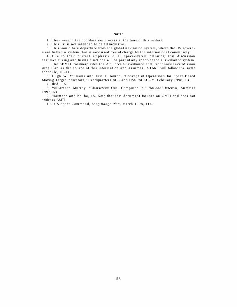
Notes
1. They were in the coordination process at the time of this writing. 2. This list is not intended to be all inclusive. 3. This would be a departure from the global navigation system, where the US govern
ment fielded a system that is now used free of charge by the international community. 4. Due to their current emphasis in all space-system planning, this discussion
assumes cueing and fusing functions will be part of any space-based surveillance system. 5. The SBMTI Roadmap cites the Air Force Surveillance and Reconnaissance Mission
Area Plan as the source of this information and assumes JSTARS will follow the same schedule, 10–11.
6. Hugh W. Youmans and Eric T. Kouba, “Concept of Operations for Space-Based Moving Target Indicators,” Headquarters ACC and USSPACECOM, February 1998, 13.
7. Ibid., 15. 8. Williamson Murray, “Clausewitz Out, Computer In,” National Interest, Summer
1997, 63. 9. Youmans and Kouba, 15. Note that this document focuses on GMTI and does not
address AMTI. 10. US Space Command, Long Range Plan, March 1998, 114.
53
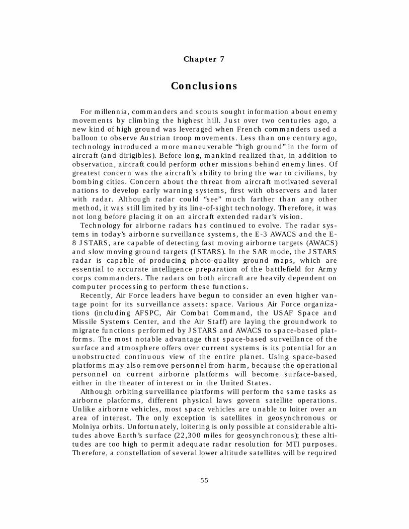
Chapter 7
Conclusions
For millennia, commanders and scouts sought information about enemy movements by climbing the highest hill. Just over two centuries ago, a new kind of high ground was leveraged when French commanders used a balloon to observe Austrian troop movements. Less than one century ago, technology introduced a more maneuverable “high ground” in the form of aircraft (and dirigibles). Before long, mankind realized that, in addition to observation, aircraft could perform other missions behind enemy lines. Of greatest concern was the aircraft’s ability to bring the war to civilians, by bombing cities. Concern about the threat from aircraft motivated several nations to develop early warning systems, first with observers and later with radar. Although radar could “see” much farther than any other method, it was still limited by its line-of-sight technology. Therefore, it was not long before placing it on an aircraft extended radar’s vision.
Technology for airborne radars has continued to evolve. The radar systems in today’s airborne surveillance systems, the E-3 AWACS and the E-8 JSTARS, are capable of detecting fast moving airborne targets (AWACS) and slow moving ground targets (JSTARS). In the SAR mode, the JSTARS radar is capable of producing photo-quality ground maps, which are essential to accurate intelligence preparation of the battlefield for Army corps commanders. The radars on both aircraft are heavily dependent on computer processing to perform these functions.
Recently, Air Force leaders have begun to consider an even higher vantage point for its surveillance assets: space. Various Air Force organizations (including AFSPC, Air Combat Command, the USAF Space and Missile Systems Center, and the Air Staff) are laying the groundwork to migrate functions performed by JSTARS and AWACS to space-based plat-forms. The most notable advantage that space-based surveillance of the surface and atmosphere offers over current systems is its potential for an unobstructed continuous view of the entire planet. Using space-based platforms may also remove personnel from harm, because the operational personnel on current airborne platforms will become surface-based, either in the theater of interest or in the United States.
Although orbiting surveillance platforms will perform the same tasks as airborne platforms, different physical laws govern satellite operations. Unlike airborne vehicles, most space vehicles are unable to loiter over an area of interest. The only exception is satellites in geosynchronous or Molniya orbits. Unfortunately, loitering is only possible at considerable altitudes above Earth’s surface (22,300 miles for geosynchronous); these altitudes are too high to permit adequate radar resolution for MTI purposes. Therefore, a constellation of several lower altitude satellites will be required
55
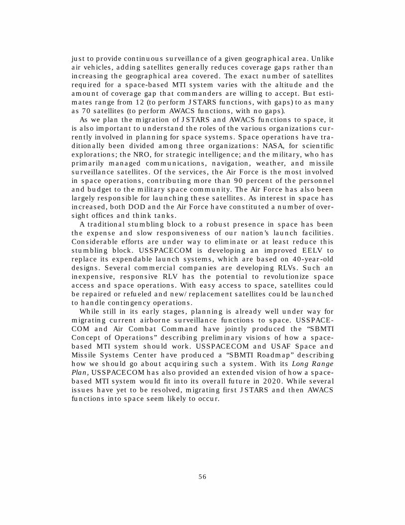
just to provide continuous surveillance of a given geographical area. Unlike air vehicles, adding satellites generally reduces coverage gaps rather than increasing the geographical area covered. The exact number of satellites required for a space-based MTI system varies with the altitude and the amount of coverage gap that commanders are willing to accept. But estimates range from 12 (to perform JSTARS functions, with gaps) to as many as 70 satellites (to perform AWACS functions, with no gaps).
As we plan the migration of JSTARS and AWACS functions to space, it is also important to understand the roles of the various organizations currently involved in planning for space systems. Space operations have traditionally been divided among three organizations: NASA, for scientific explorations; the NRO, for strategic intelligence; and the military, who has primarily managed communications, navigation, weather, and missile surveillance satellites. Of the services, the Air Force is the most involved in space operations, contributing more than 90 percent of the personnel and budget to the military space community. The Air Force has also been largely responsible for launching these satellites. As interest in space has increased, both DOD and the Air Force have constituted a number of over-sight offices and think tanks.
A traditional stumbling block to a robust presence in space has been the expense and slow responsiveness of our nation’s launch facilities. Considerable efforts are under way to eliminate or at least reduce this stumbling block. USSPACECOM is developing an improved EELV to replace its expendable launch systems, which are based on 40-year-old designs. Several commercial companies are developing RLVs. Such an inexpensive, responsive RLV has the potential to revolutionize space access and space operations. With easy access to space, satellites could be repaired or refueled and new/replacement satellites could be launched to handle contingency operations.
While still in its early stages, planning is already well under way for migrating current airborne surveillance functions to space. USSPACECOM and Air Combat Command have jointly produced the “SBMTI Concept of Operations” describing preliminary visions of how a space-based MTI system should work. USSPACECOM and USAF Space and Missile Systems Center have produced a “SBMTI Roadmap” describing how we should go about acquiring such a system. With its Long Range Plan, USSPACECOM has also provided an extended vision of how a space-based MTI system would fit into its overall future in 2020. While several issues have yet to be resolved, migrating first JSTARS and then AWACS functions into space seem likely to occur.
56