Embed Size (px)
Citation preview

HHS emPOWER Initiative Demo: Using Medicare De-Identified and Individual Data, Maps, and Tools for Access and Functional Needs Emergency Preparedness, Response, Recovery, and
Resilience Activities
Contact Information
Kristen P. Finne, B.A.
Lead, HHS emPOWER Initiative
Senior Policy Analyst, Division of Health Systems Policy
Office of the Assistant Secretary for Preparedness and Response
U.S. Department of health and Human Services
Sean J. Britton, NRP, CPH, CEM
Deputy Director of Public Health
Deputy Emergency Medical Services Coordinator
Broome County Health Department
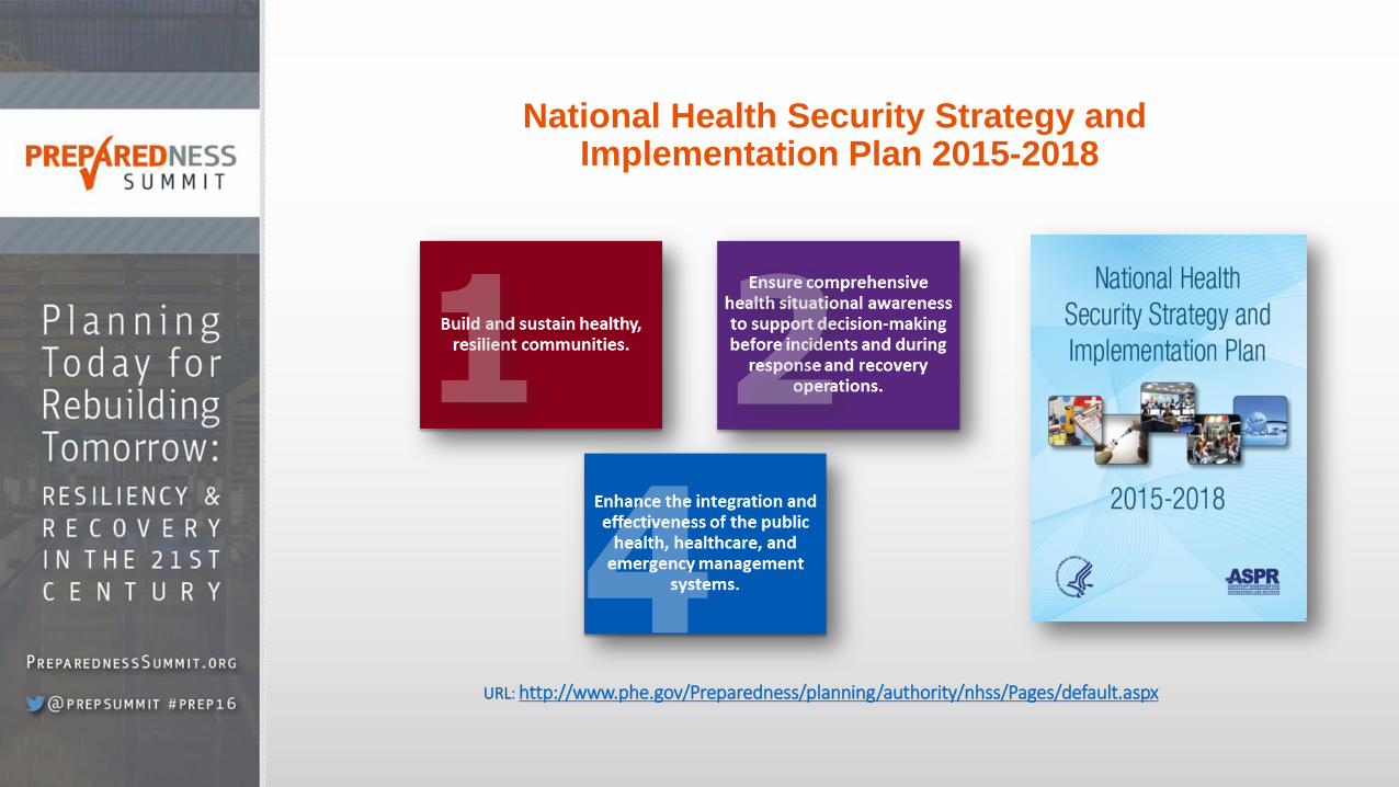
National Health Security Strategy and Implementation Plan 2015-2018
URL: http://www.phe.gov/Preparedness/planning/authority/nhss/Pages/default.aspx

Do you know who lives in your community and what their access and functional needs are?
Can we help a community better understand how many at-risk individuals with access and functional needs rely upon electricity-dependent medical and assistive equipment, healthcare services, and their local healthcare system- daily, weekly, monthly? Can we better understand, assess, and mitigate disaster-induced healthcare system stress and its impact on access, utilization, and health outcomes for at-risk populations with access and functional needs?
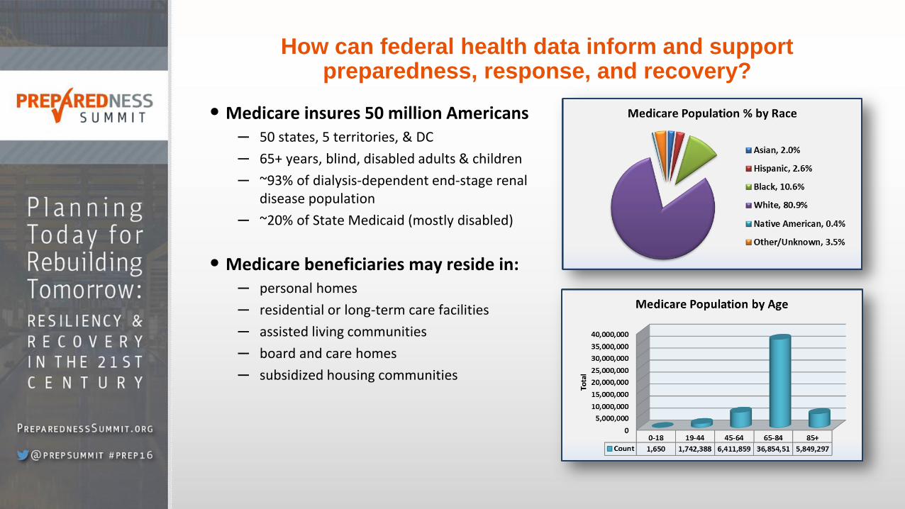
How can federal health data inform and support preparedness, response, and recovery?
• Medicare insures 50 million Americans ─ 50 states, 5 territories, & DC
─ 65+ years, blind, disabled adults & children
─ ~93% of dialysis-dependent end-stage renal disease population
─ ~20% of State Medicaid (mostly disabled)
• Medicare beneficiaries may reside in: ─ personal homes
─ residential or long-term care facilities
─ assisted living communities
─ board and care homes
─ subsidized housing communities
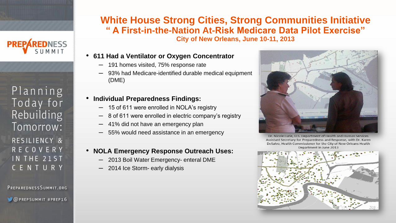
White House Strong Cities, Strong Communities Initiative “ A First-in-the-Nation At-Risk Medicare Data Pilot Exercise”
City of New Orleans, June 10-11, 2013
• 611 Had a Ventilator or Oxygen Concentrator
─ 191 homes visited, 75% response rate
─ 93% had Medicare-identified durable medical equipment
(DME)
• Individual Preparedness Findings:
─ 15 of 611 were enrolled in NOLA’s registry
─ 8 of 611 were enrolled in electric company’s registry
─ 41% did not have an emergency plan
─ 55% would need assistance in an emergency
• NOLA Emergency Response Outreach Uses:
─ 2013 Boil Water Emergency- enteral DME
─ 2014 Ice Storm- early dialysis
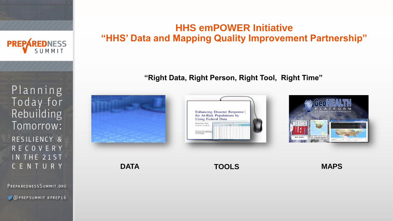
HHS emPOWER Initiative “HHS’ Data and Mapping Quality Improvement Partnership”
DATA TOOLS MAPS
“Right Data, Right Person, Right Tool, Right Time”

National HHS emPOWER Dataset Data as of 1/27/2016
• 3.8M at-risk Medicare beneficiaries living at
home independently
• Medicare at-risk data types include:
─ Electricity-Dependent Durable Medical
Equipment (DME)
• Ventilators
• Oxygen concentrators
• Enteral feeding machines
• Intravenous (IV) pumps
• Suction pumps
• At-home dialysis machines
• Electric Wheelchairs/scooters
• Electric Beds
─ Oxygen (O2) Tank Services
─ Dialysis Services (facility/home)
─ Home Health Services
• Medicare at-risk data types include:
─ De-identified-restricted & public
─ Individual-restricted to public health authorities
Data as of 1/27/2016
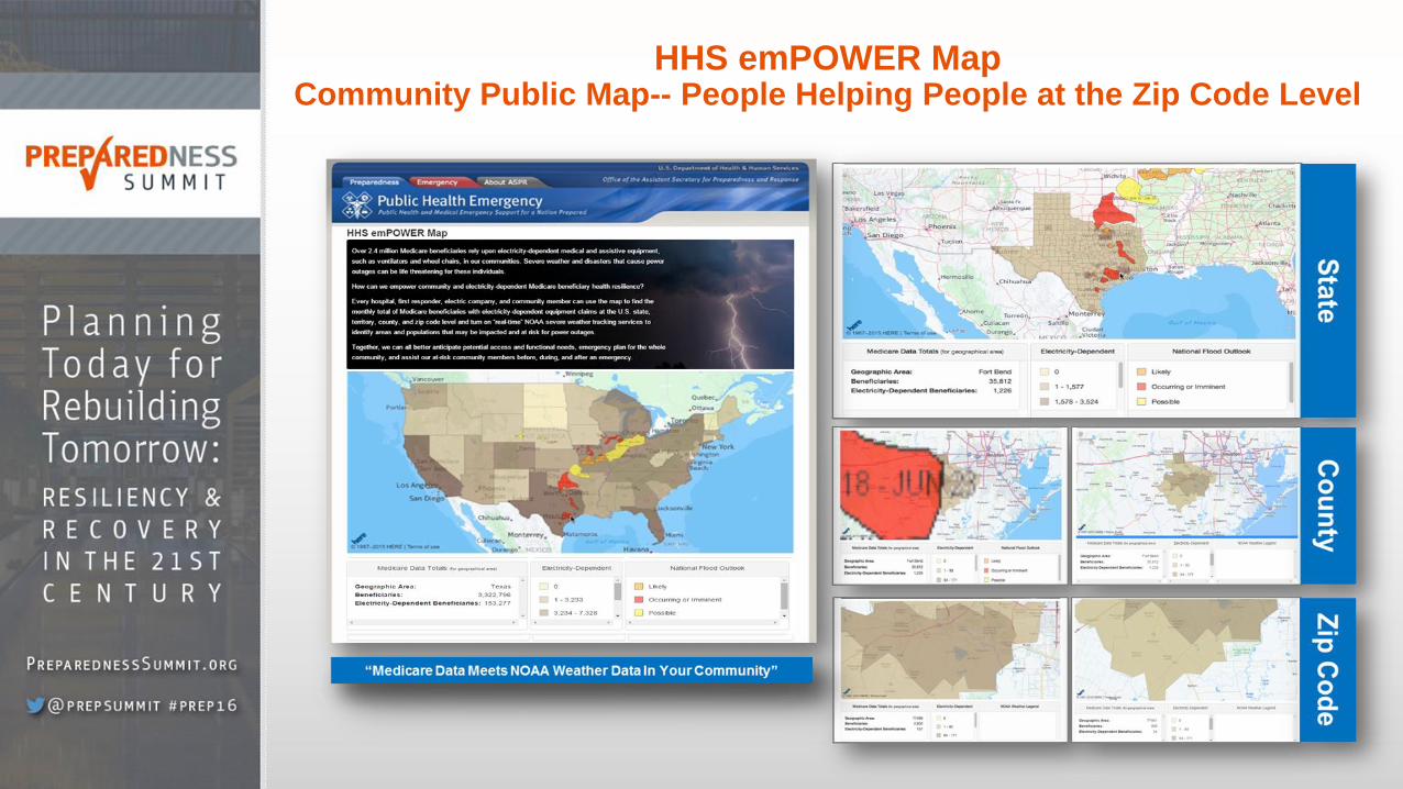
HHS emPOWER Map Community Public Map-- People Helping People at the Zip Code Level

What data can I find? How can I use the HHS emPOWER Map?
• De-identified Data: ─ Monthly # Medicare beneficiaries
─ Monthly # of electricity-dependent Medicare beneficiaries- Recent claim for
8 types of electricity-dependent durable medical
equipment (DME)
• NOAA Severe Weather Tracking ─ Hurricane*
─ Radar
─ Precipitation*
─ Storm Prediction*
─ Flood Outlook*
─ None- default
• Background Maps (ESRI) ─ Base map*
─ Topographic*
─ Streets*
─ Satellite*
─ Hybrid
─ Grey
─ Dark Grey
─ Oceans
─ National Geographic
─ Terrain*
─ Open Street Map
Or Use the Drop Down to Select a
State, County, and then Zip Code
for Data Select
Base Map
Select
Weather Reset
Select an
Area by
Hovering
Your Mouse
Over a State,
County, and
then Zip Code
to find data in
the Medicare
Data Total
Section or in
the Dynamic
Table Below

Can I consume and display the HHS emPOWER Map rest service in our GIS system?
YES! First locate your GIS expert, then them the great news, and ask them to:
Go to: Geohealth.hhs.gov
https://geohealth.hhs.gov/dataaccess/rest/services/CMS_D
ME/HHS_CMS_DME_ESRD_onlyAll/MapServer
Go directly to the URL:
Click on
More
Details
Scroll to Map
contents and
click on the
“HHS_CMS_D
ME_ESRD_onl
yAll” for the
end points
Here are the end points for the
State/Territory, County and Zip
Code Level Data Layers
OR

HHS emPOWER Initiative State Health Department De-identified Emergency Planning Datasets
• Provides more granular de-identified data:
o Medicare totals by type of DME and healthcare
services
• Sample Use Cases: o Informing power restoration prioritization
decision making at all levels
o Identifying optimal locations, support, and
power needs for multiple devices in general
population shelters
o Assessing potential transportation needs for
evacuating or transport to healthcare providers
(e.g. dialysis)
o Anticipating potential EMAC requests for at-risk
populations residing by borders
o Sets the stage for life-saving assistance
http://geohealth.hhs.gov/arcgis/home/
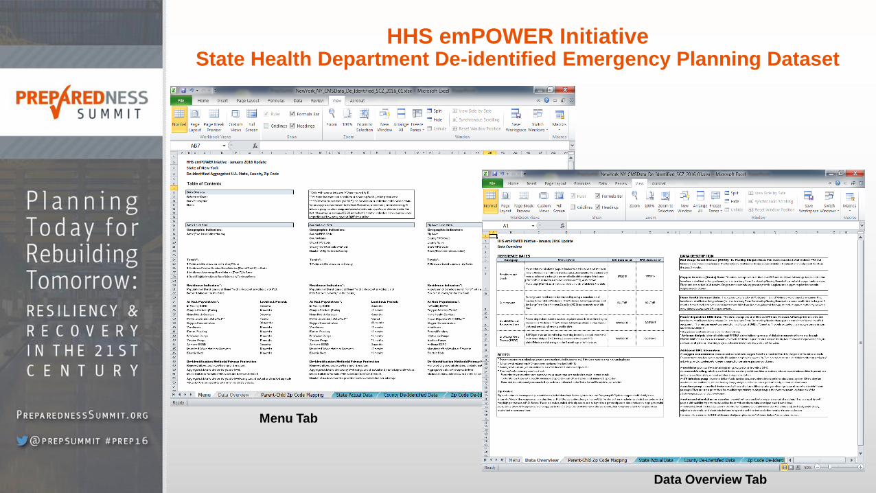
HHS emPOWER Initiative State Health Department De-identified Emergency Planning Dataset
Menu Tab
Data Overview Tab
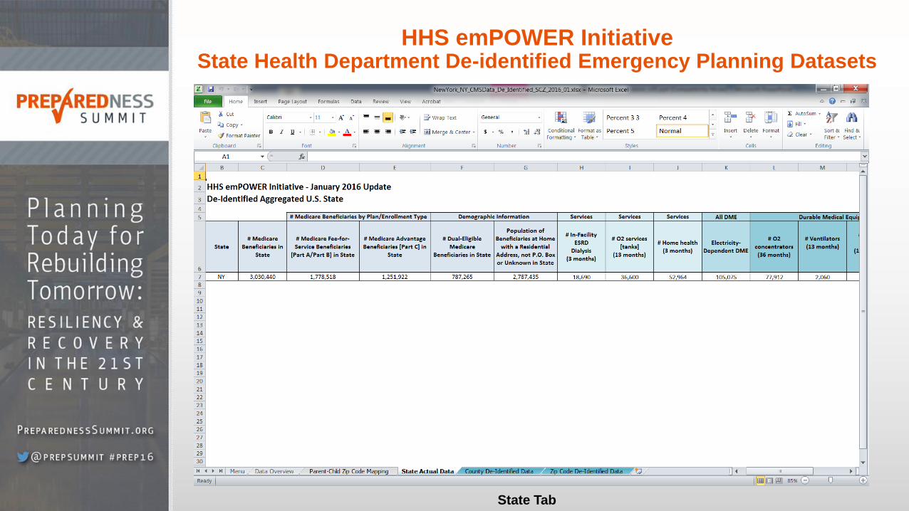
HHS emPOWER Initiative State Health Department De-identified Emergency Planning Datasets
State Tab

HHS emPOWER Initiative State Health Department De-identified Emergency Planning Dataset
State Tab
County Tab
Note: Every Column is Sortable
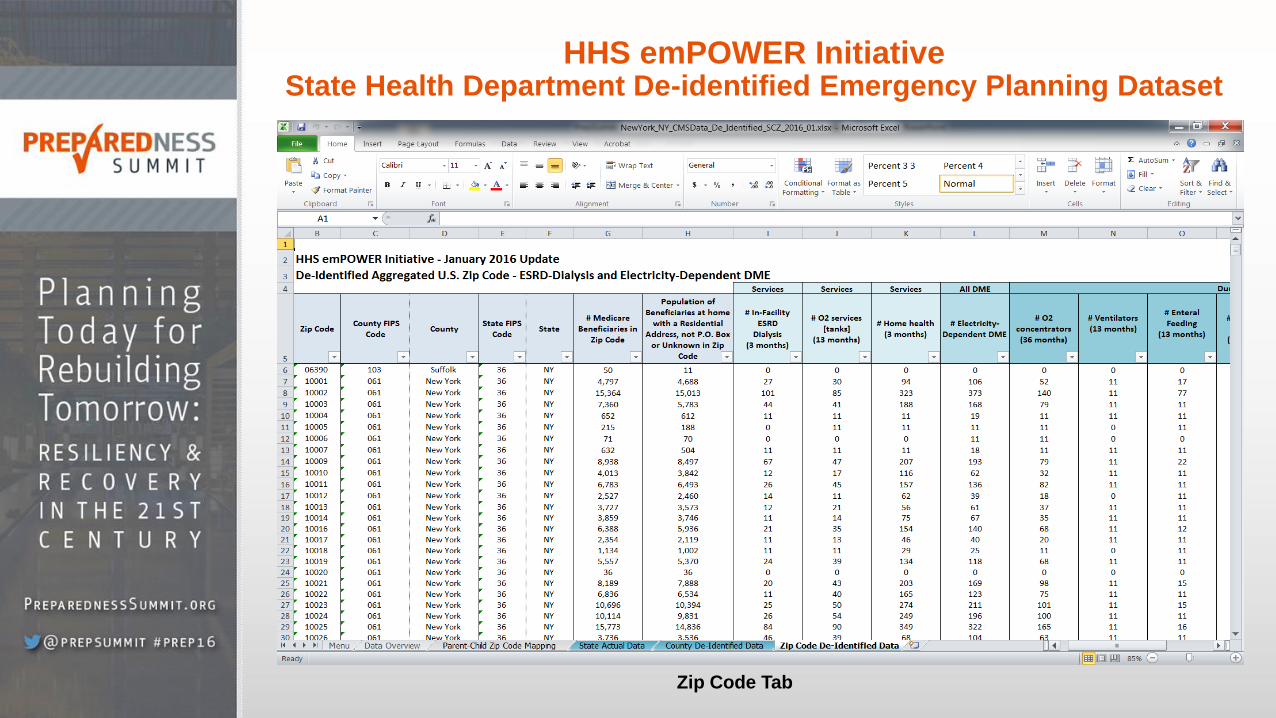
HHS emPOWER Initiative State Health Department De-identified Emergency Planning Dataset
Zip Code Tab
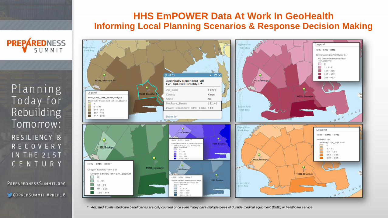
HHS EmPOWER Data At Work In GeoHealth Informing Local Planning Scenarios & Response Decision Making
* Adjusted Totals- Medicare beneficiaries are only counted once even if they have multiple types of durable medical equipment (DME) or healthcare service

HHS emPOWER Initiative Emergency Response Outreach Individual Dataset
• Purpose is to conduct outreach prior to, during, or after an incident, public health emergency, or disaster that may adversely impact at-risk populations
• Examples of individual outreach use cases:
─ HHS approved preparedness exercises: • City of New Orleans, State of Arizona, Broome
County/New York State, New York City*
─ HHS approved emergencies: • Flint Michigan Water Emergency, Virginia and NYC
Winter Storm Jonas Emergency, City of New Orleans Boil Water Emergency, Dialysis/Ice Storm Emergency
• Future Responses
• Public health authorities that meet HIPAA requirements can submit a request to HHS via their ASPR Regional Administrator (RA)/Emergency Coordinators (RECs)
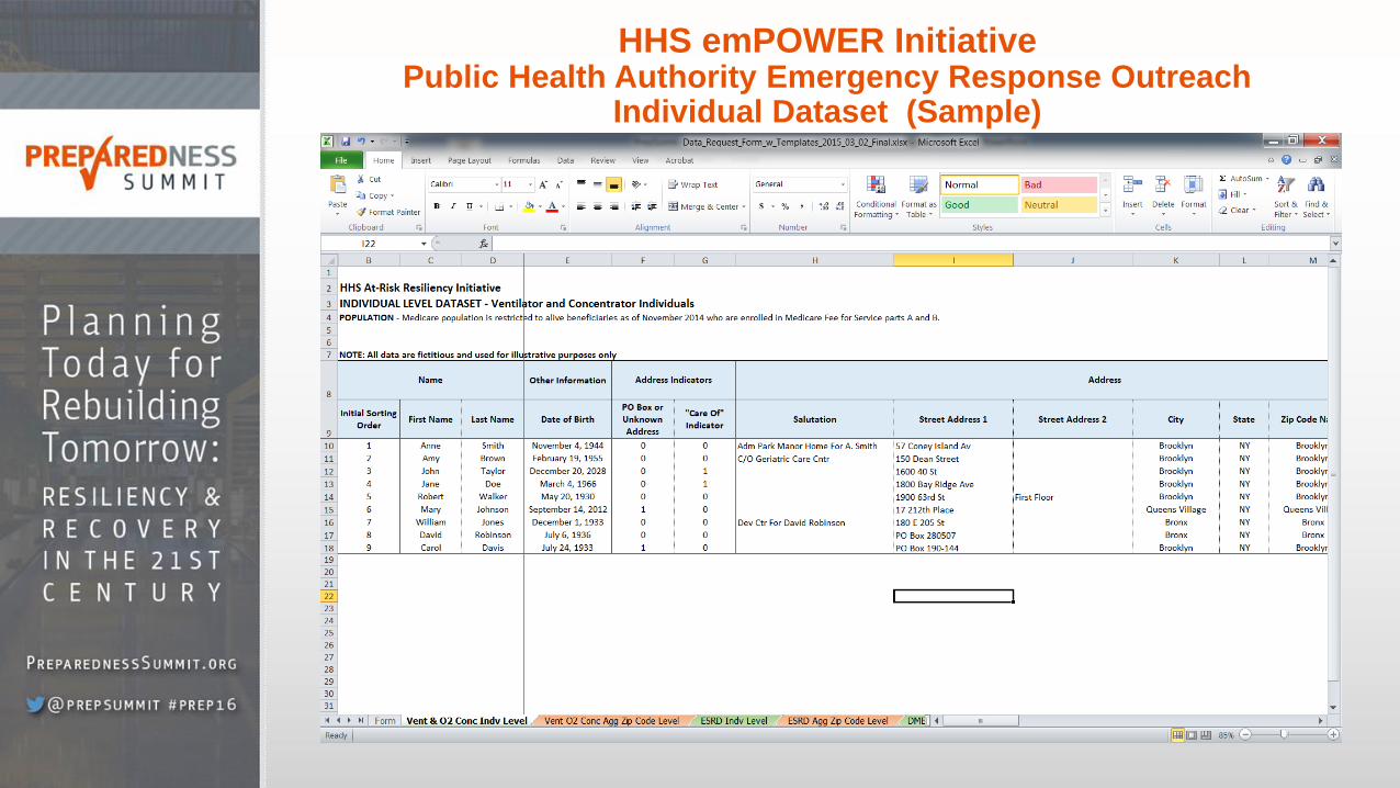
HHS emPOWER Initiative Public Health Authority Emergency Response Outreach
Individual Dataset (Sample)
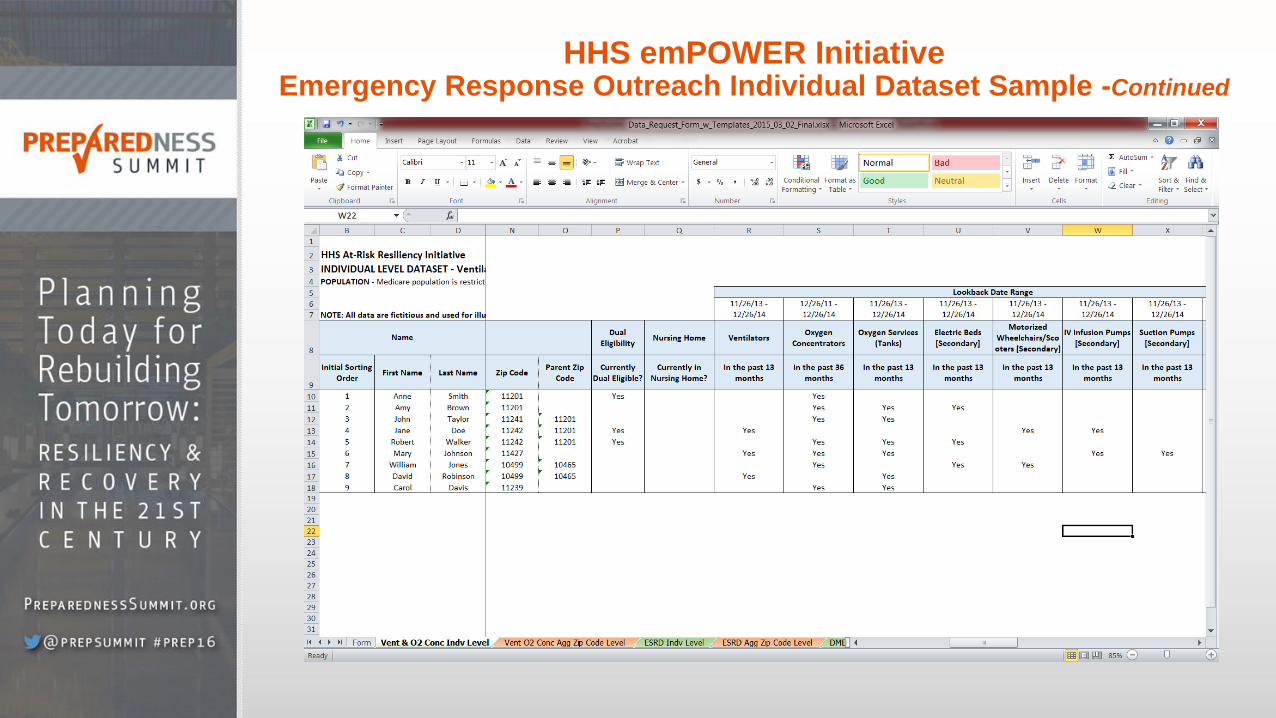
HHS emPOWER Initiative Emergency Response Outreach Individual Dataset Sample -Continued

HHS emPOWER Initiative
Emergency Response Outreach Individual Dataset Sample-Continued
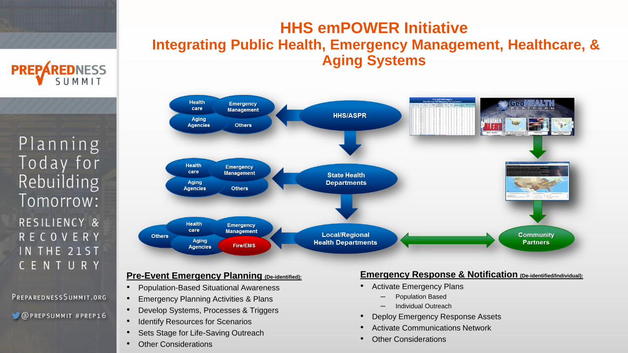
HHS emPOWER Initiative Integrating Public Health, Emergency Management, Healthcare, &
Aging Systems
Pre-Event Emergency Planning (De-identified):
• Population-Based Situational Awareness
• Emergency Planning Activities & Plans
• Develop Systems, Processes & Triggers
• Identify Resources for Scenarios
• Sets Stage for Life-Saving Outreach
• Other Considerations
Emergency Response & Notification (De-identified/Individual):
• Activate Emergency Plans
─ Population Based
─ Individual Outreach
• Deploy Emergency Response Assets
• Activate Communications Network
• Other Considerations

HHS emPOWER Data in Action
How can emPOWER data and tools inform and support emergency preparedness, response, recovery and
resilience activities in your communities?
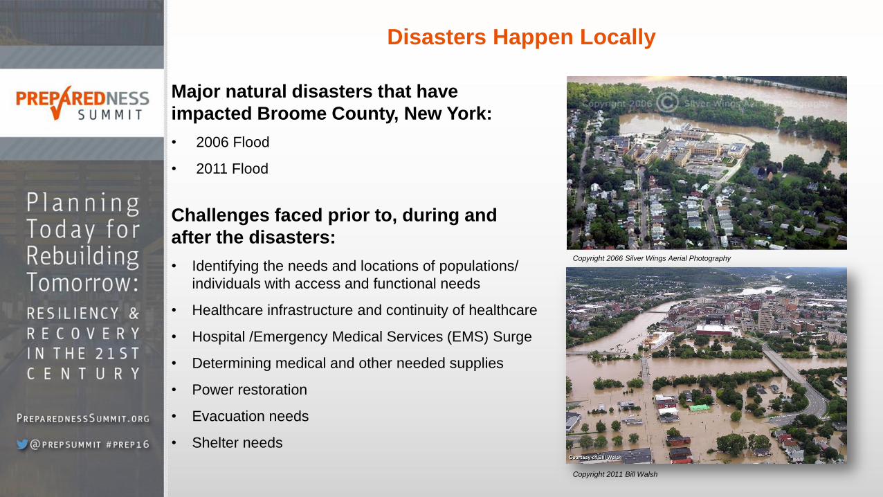
Disasters Happen Locally
Major natural disasters that have
impacted Broome County, New York:
• 2006 Flood
• 2011 Flood
Challenges faced prior to, during and
after the disasters:
• Identifying the needs and locations of populations/
individuals with access and functional needs
• Healthcare infrastructure and continuity of healthcare
• Hospital /Emergency Medical Services (EMS) Surge
• Determining medical and other needed supplies
• Power restoration
• Evacuation needs
• Shelter needs
Copyright 2066 Silver Wings Aerial Photography
Copyright 2011 Bill Walsh
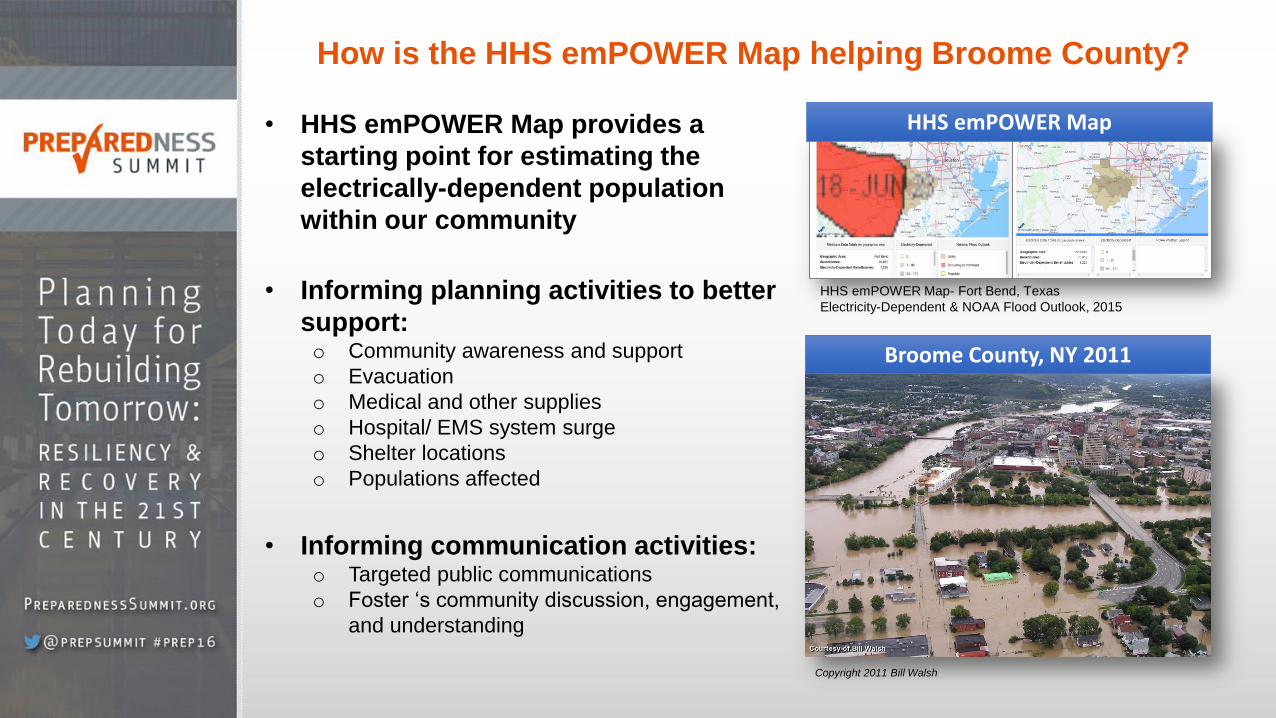
How is the HHS emPOWER Map helping Broome County?
• HHS emPOWER Map provides a
starting point for estimating the
electrically-dependent population
within our community
• Informing planning activities to better
support: o Community awareness and support
o Evacuation
o Medical and other supplies
o Hospital/ EMS system surge
o Shelter locations
o Populations affected
• Informing communication activities:
o Targeted public communications
o Foster ‘s community discussion, engagement,
and understanding
HHS emPOWER Map- Fort Bend, Texas
Electricity-Dependent & NOAA Flood Outlook, 2015
HHS emPOWER Map
Copyright 2011 Bill Walsh
Broome County, NY 2011
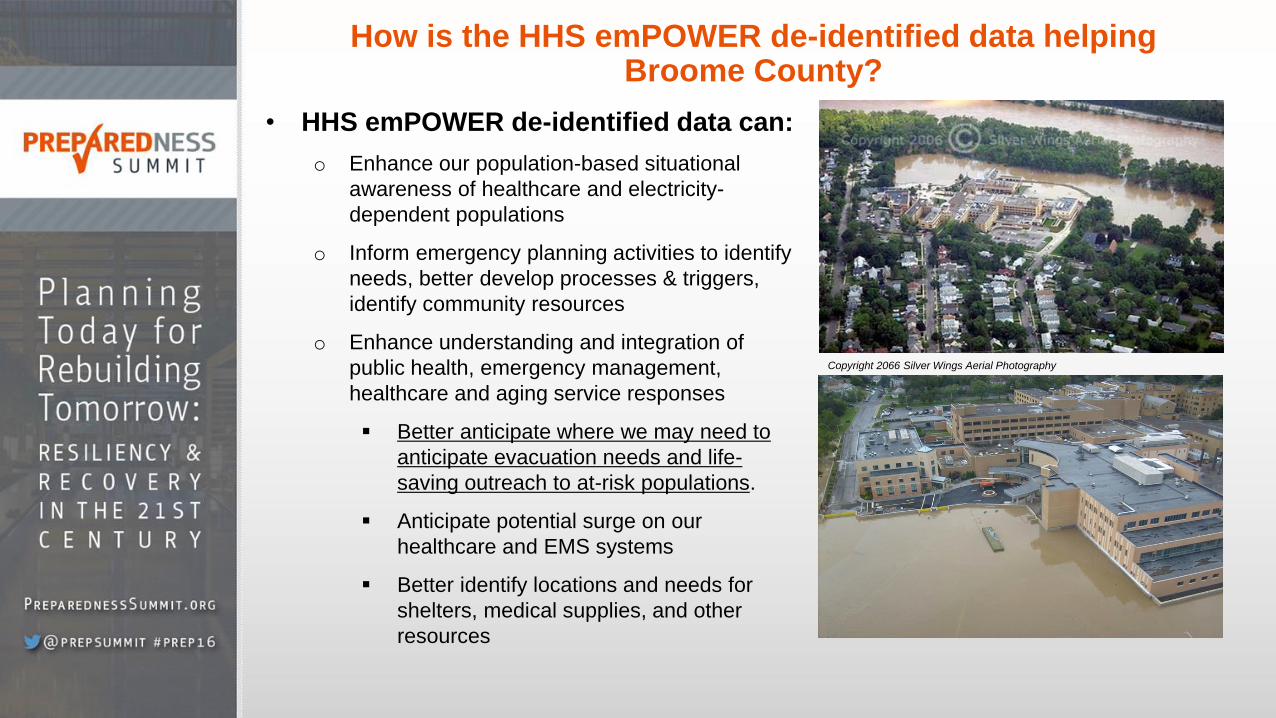
How is the HHS emPOWER de-identified data helping Broome County?
• HHS emPOWER de-identified data can:
o Enhance our population-based situational
awareness of healthcare and electricity-
dependent populations
o Inform emergency planning activities to identify
needs, better develop processes & triggers,
identify community resources
o Enhance understanding and integration of
public health, emergency management,
healthcare and aging service responses
Better anticipate where we may need to
anticipate evacuation needs and life-
saving outreach to at-risk populations.
Anticipate potential surge on our
healthcare and EMS systems
Better identify locations and needs for
shelters, medical supplies, and other
resources
Copyright 2066 Silver Wings Aerial Photography
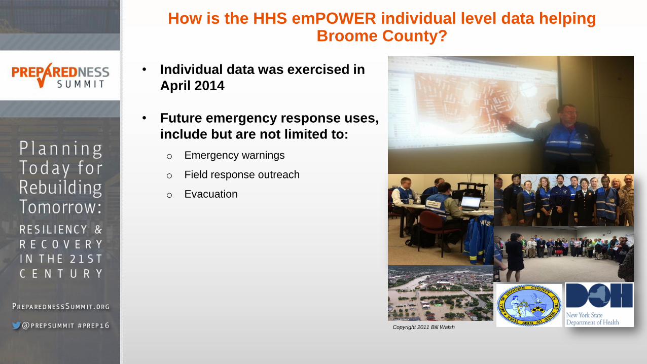
How is the HHS emPOWER individual level data helping Broome County?
• Individual data was exercised in
April 2014
• Future emergency response uses,
include but are not limited to:
o Emergency warnings
o Field response outreach
o Evacuation
Copyright 2011 Bill Walsh
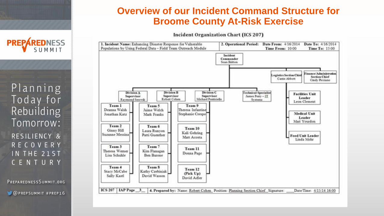
Overview of our Incident Command Structure for Broome County At-Risk Exercise
Questions?
Contact Information
Kristen P. Finne, B.A.
Lead, HHS emPOWER Initiative
Senior Policy Analyst, Division of Health Systems Policy
Office of the Assistant Secretary for Preparedness and Response
U.S. Department of health and Human Services
Office: 202-691-2013
Email: [email protected]
HHS emPOWER Map: www.phe.gov/empowermap
HHS GeoHealth emPOWER Rest Service: https://geohealth.hhs.gov/dataaccess/rest/services/CMS_DME/HHS_CMS_DME_ESRD_onlyAll/MapServer
HHS GeoHealth Platform: www.geohealth.hhs.gov
HHS Technical Resources Assistance Center and Information Exchange (TRACIE) https://asprtracie.hhs.gov/
HHS Response and Recovery Resources Compendium: http://www.phe.gov/emergency/hhscapabilities/Pages/default.aspx
Sean J. Britton, NRP, CPH, CEM
Deputy Director of Public Health
Deputy Emergency Medical Services Coordinator
Broome County Health Department
Office: 607-778-3944
Email: [email protected]
Website: http://www.gobroomecounty.com/hd
Facebook: www.facebook.com/BroomeCountyHealth
Facebook: www.facebook.com/BCOES