Embed Size (px)
Citation preview
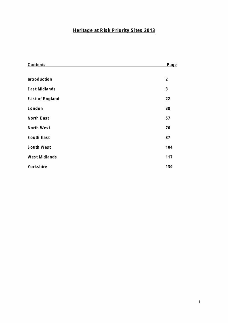
Heritage at Risk Priority Sites 2013
Contents Page
Introduction 2
East Midlands 3
East of England 22
London 38
North East 57
North West 76
South East 87
South West 104
West Midlands 117
Yorkshire 130
1
Introduction
What are Priority Heritage at Risk Sites?
Priority Heritage at Risk sites are those sites that English Heritage has identified for additional support to save them for the future. We will be working with owners, developers, trusts and local authorities to find the right solution for these sites with the aim of getting them repaired and back into sustainable use where possible, so they can be removed from the Heritage at Risk Register.
Solutions will vary from site to site, possibly with more than one option and so the support that English Heritage will provide is site and option dependent. The different kinds of support could include one or more activities such as expert local advice, partnership working with local authorities, updated information on the significance of the site to aid understanding, and grant aid.
For further information or to discuss a site on the priority list contact the relevant English Heritage office.
• East Midlands Tel: 01480 412107
Ben Robinson Email: [email protected]
• East of England Tel: 01223 582711
John Ette Email: [email protected]
• London Tel: 020 7973 3488
Nigel Barker Email: [email protected]
• North East Tel: 0191 269 1221
Kate Wilson Email: [email protected]
• North West Tel: 0161 242 1436
Charles Smith Email: [email protected]
• South East Tel: 01483 252000
Clare Charlesworth Email: [email protected]
• South West Tel: 0117 975 0687
Ruth Garner Email: [email protected]
• West Midlands Tel: 0121 625 6886
Sarah Lewis Email: [email protected]
• Yorkshire Tel: 01904 601880
Tammy Whitaker Email: [email protected]
2
East Midlands Heritage at Risk Priority Sites 2013
• Boston Conservation Area, Lincolnshire
• Chester House, Higham Road, Irchester, Wellingborough, Northamptonshire
• Derwent Valley Mills World Heritage Site: North Mill, Bridge Foot, Belper and Darley Abbey Mills (Long Mill, West Mill, North Mill, Engine House, Boiler House, preparation building, cottage, workshop and cart sheds), Old Lane, Derby
• Former Maltings of Bass Industrial Estate, Mareham Lane, Sleaford, North Kesteven, Lincolnshire
• Harlaxton Manor, Harlaxton (Registered Park and Garden), South Kesteven, Lincolnshire
• Scraptoft Hall, Church Hill, Scraptoft, Harborough, Leicestershire
• Snibston Colliery, Ashby Road, North West Leicestershire
• The Crescent, Buxton, High Peak, Derbyshire
• The Station Conservation Area, Nottingham
• Worksop Priory gatehouse, Cheapside, Worksop, Bassetlaw, Nottinghamshire
The East Midlands office is also responsible for the priority site of Grimsby Ice Factory, which appears on the Yorkshire Heritage at Risk Register.
3
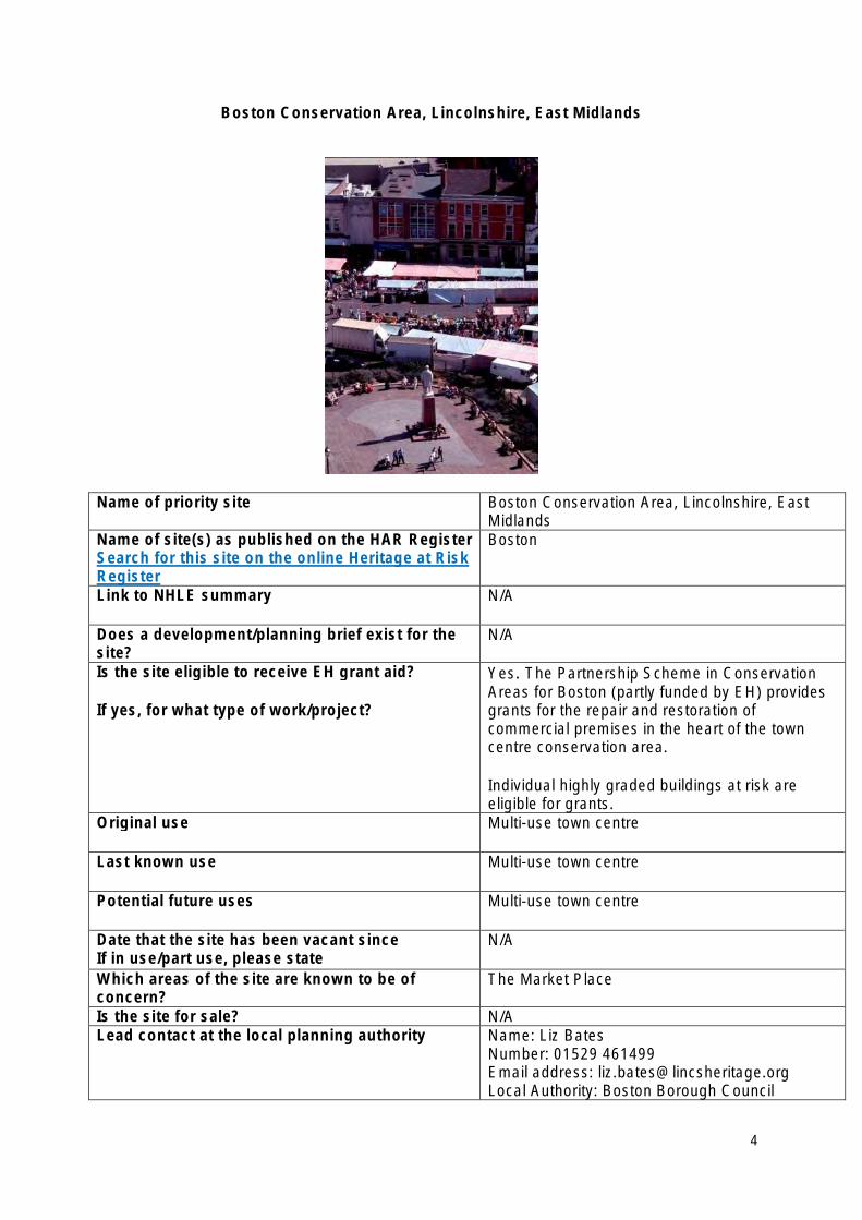
Boston Conservation Area, Lincolnshire, East Midlands
Name of priority site Boston Conservation Area, Lincolnshire, East Midlands
Name of site(s) as published on the HAR Register Search for this site on the online Heritage at Risk Register
Boston
Link to NHLE summary N/A
Does a development/planning brief exist for the site?
N/A
Is the site eligible to receive EH grant aid?
If yes, for what type of work/project?
Yes. The Partnership Scheme in Conservation Areas for Boston (partly funded by EH) provides grants for the repair and restoration of commercial premises in the heart of the town centre conservation area.
Individual highly graded buildings at risk are eligible for grants.
Original use Multi-use town centre
Last known use Multi-use town centre
Potential future uses Multi-use town centre
Date that the site has been vacant since If in use/part use, please state
N/A
Which areas of the site are known to be of concern?
The Market Place
Is the site for sale? N/A Lead contact at the local planning authority Name: Liz Bates
Number: 01529 461499 Email address: [email protected] Local Authority: Boston Borough Council
4
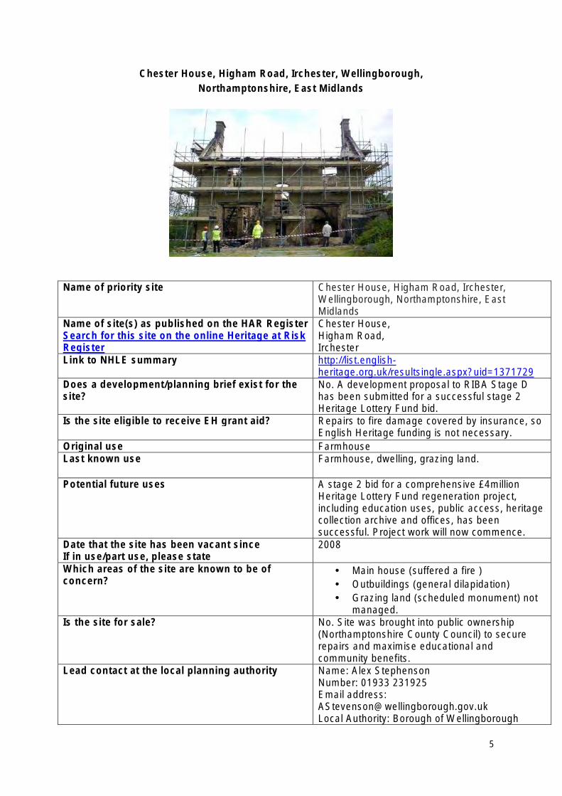
Chester House, Higham Road, Irchester, Wellingborough, Northamptonshire, East Midlands
Name of priority site Chester House, Higham Road, Irchester, Wellingborough, Northamptonshire, East Midlands
Name of site(s) as published on the HAR Register Search for this site on the online Heritage at Risk Register
Chester House, Higham Road, Irchester
Link to NHLE summary http://list.englishheritage.org.uk/resultsingle.aspx?uid=1371729
Does a development/planning brief exist for the site?
No. A development proposal to RIBA Stage D has been submitted for a successful stage 2 Heritage Lottery Fund bid.
Is the site eligible to receive EH grant aid? Repairs to fire damage covered by insurance, so English Heritage funding is not necessary.
Original use Farmhouse Last known use Farmhouse, dwelling, grazing land.
Potential future uses A stage 2 bid for a comprehensive £4million Heritage Lottery Fund regeneration project, including education uses, public access, heritage collection archive and offices, has been successful. Project work will now commence.
Date that the site has been vacant since If in use/part use, please state
2008
Which areas of the site are known to be of concern?
• Main house (suffered a fire ) • Outbuildings (general dilapidation) • Grazing land (scheduled monument) not
managed. Is the site for sale? No. Site was brought into public ownership
(Northamptonshire County Council) to secure repairs and maximise educational and community benefits.
Lead contact at the local planning authority Name: Alex Stephenson Number: 01933 231925 Email address: [email protected] Local Authority: Borough of Wellingborough
5
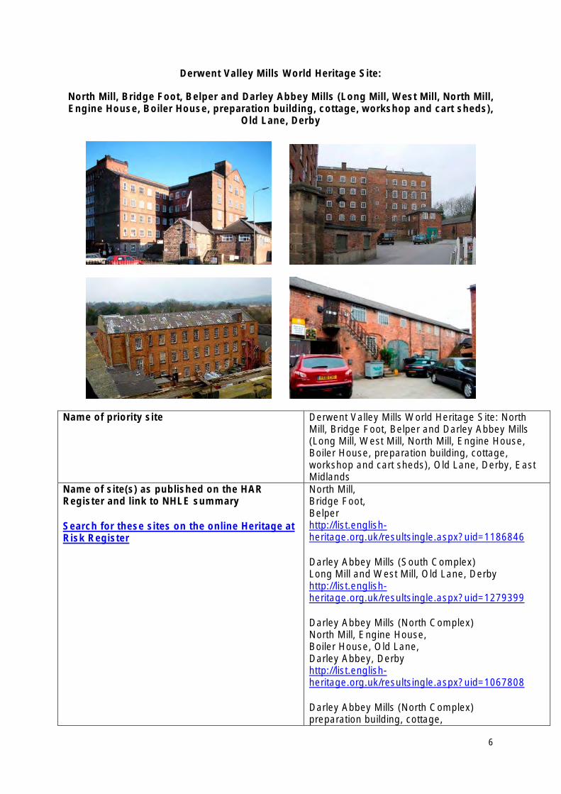
Derwent Valley Mills World Heritage Site:
North Mill, Bridge Foot, Belper and Darley Abbey Mills (Long Mill, West Mill, North Mill, Engine House, Boiler House, preparation building, cottage, workshop and cart sheds),
Old Lane, Derby
Name of priority site Derwent Valley Mills World Heritage Site: North Mill, Bridge Foot, Belper and Darley Abbey Mills (Long Mill, West Mill, North Mill, Engine House, Boiler House, preparation building, cottage, workshop and cart sheds), Old Lane, Derby, East Midlands
Name of site(s) as published on the HAR Register and link to NHLE summary
Search for these sites on the online Heritage at Risk Register
North Mill, Bridge Foot, Belper http://list.englishheritage.org.uk/resultsingle.aspx?uid=1186846
Darley Abbey Mills (South Complex) Long Mill and West Mill, Old Lane, Derby http://list.englishheritage.org.uk/resultsingle.aspx?uid=1279399
Darley Abbey Mills (North Complex) North Mill, Engine House, Boiler House, Old Lane, Darley Abbey, Derby http://list.englishheritage.org.uk/resultsingle.aspx?uid=1067808
Darley Abbey Mills (North Complex) preparation building, cottage,
6
workshop & cart sheds, Old Lane, Darley Abbey, Derby http://list.englishheritage.org.uk/resultsingle.aspx?uid=1067809
Does a development/planning brief exist for the North Mill: No, but previous options appraisals site? have been undertaken
If yes, when was this produced Darley Abbey Mills: Yes - Derby City Council commissioned a Regeneration Strategy (September 2010).
Is the site eligible to receive EH grant aid? North Mill: Available information does not indicate a conservation deficit, hence unlikely to be eligible
If yes, for what type of work/project? for EH grant.
Darley Abbey Mills: Yes. A project development grant has been offered. Urgent temporary repairs to roofs of North Mill, Mill Managers House and preparation building (proto-fireproof building). Various other high level works to other mill buildings may be eligible, depending upon ability to meet criteria in each case.
Original use North Mill: Textile Mill.
Darley Abbey Mills: multi-phase cotton textile factory
Last known use North Mill: Currently in partial use as museum and commercial offices.
Darley Abbey Mills: Darley Abbey Mills (south complex): textile factory (north complex): currently a mix of light industrial and office use with part vacancy (preparation building, cottage, workshop): currently a mix of light industrial, office, commercial use with part vacancy.
Potential future uses North Mill: current use as a museum and offices likely to continue. Alternative uses would require thorough exploration in terms of their economic viability and impact on the special interest of the building. Potential uses for the wider site, including the grade II listed East Mill, were examined as part of an Economic Development Plan commissioned by the Derwent Valley Mills World Heritage Site Partnership.
Darley Abbey Mills: some uses may continue. Alternative uses would require thorough exploration in terms of their economic viability and impact on the special interest of the buildings. Potential uses for the wider site were examined as part of the Darley Abbey Mills Regeneration Strategy and as part of an Economic Development Plan commissioned by the Derwent Valley Mills
7
World Heritage Site Partnership. Date that the site has been vacant since
If in use/part use, please state
North Mill: In partial use. Attic storey is vacant and has been since approximately 2000.
Darley Abbey Mills (south complex): vacant (north complex); continuing in partial use; preparation building, cottage, workshop, cart sheds: continuing in partial use.
Which areas of the site are known to be of concern?
North Mill: roof is of particular concern. Temporary repairs have been carried out but a new roof is required. Currently being monitored by the local planning authority and English Heritage.
Darley Abbey Mills: there are areas of concern throughout the whole site, including:
• roofs • brickwork to buildings, particularly at high
level • timberwork (fenestration, doors)
Is the site for sale? No
Lead contact at the local planning authority North Mill: Name: Mrs Rachael Coates Number: 01773 841585 Email address: [email protected] Local Authority: Amber Valley Borough Council
Darley Abbey Mills: Name: Mr Chris Pook Number: 01332 641623 Email Address: [email protected] Local Authority: Derby City Council
8
Former maltings of Bass Industrial Estate, Mareham Lane, Sleaford, North Kesteven, Lincolnshire, East Midlands
Name of priority site Former maltings of Bass Industrial Estate, Mareham Lane, Sleaford, North Kesteven, Lincolnshire, East Midlands
Name of site(s) as published on the HAR Register Search for this site on the online Heritage at Risk Register
Former maltings of Bass Industrial Estate, Mareham Lane, Sleaford
Link to NHLE summary http://list.englishheritage.org.uk/resultsingle.aspx?uid=1062154
Does a development/planning brief exist for the site? If yes, when was this produced
Yes, adopted Supplementary Planning Document produced April 2006.
Is the site eligible to receive EH grant aid? If yes, for what type of work/project?
Yes Repair.
Original use Maltings for the Bass Brewery Last known use Mushroom farm Potential future uses Planning Permission has been granted for
a mixed use development to include: • Residential • Office • Medical • Retail • Car parking
Date that the site has been vacant since If in use/part use, please state
1957
Which areas of the site are known to be of concern?
All buildings on the site.
Is the site for sale? Contact details for the agent
No, acquired previously for development of an agreed scheme.
Lead contact at the local planning authority Name: Phillip Rowson Number: 01529 414155 Email address: Phillip_Rowson@nkesteven.gov.uk Local Authority: North Kesteven District Council
9
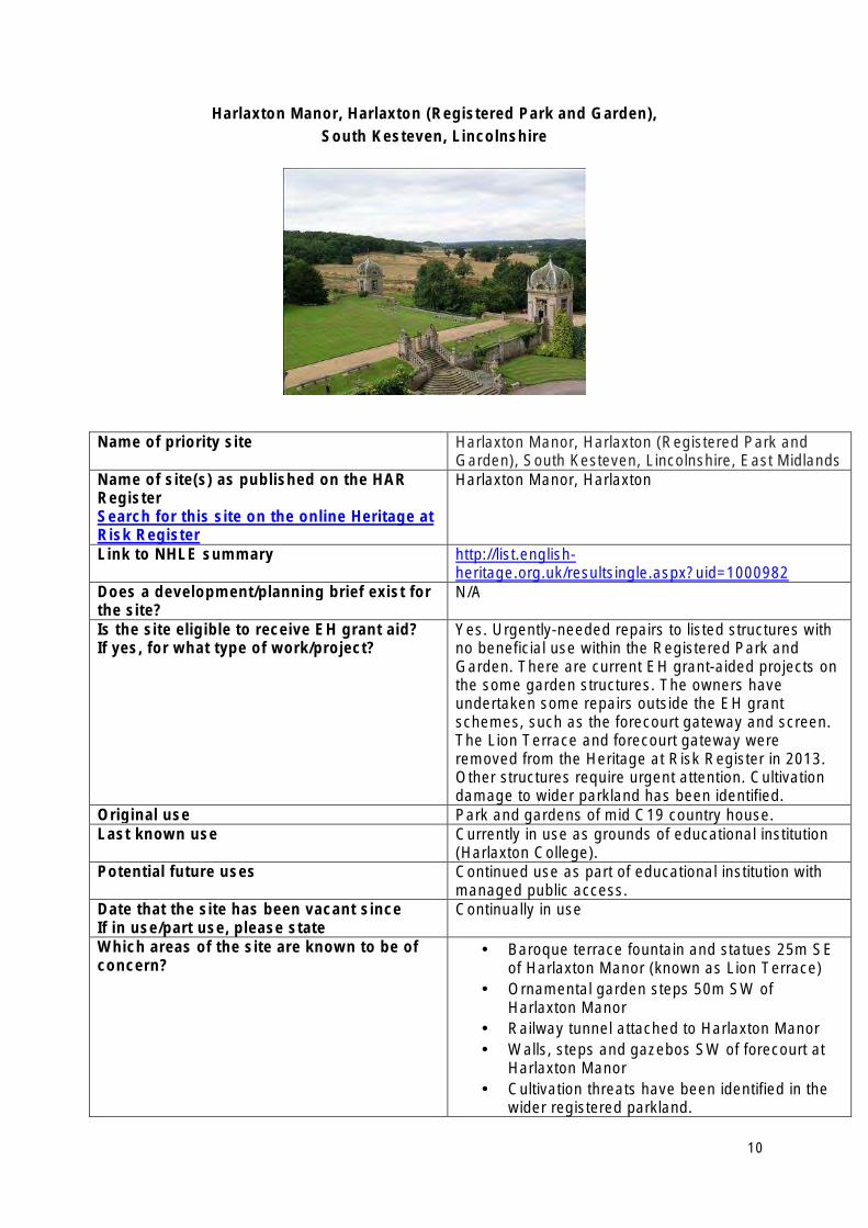
Harlaxton Manor, Harlaxton (Registered Park and Garden), South Kesteven, Lincolnshire
Name of priority site Harlaxton Manor, Harlaxton (Registered Park and Garden), South Kesteven, Lincolnshire, East Midlands
Name of site(s) as published on the HAR Register Search for this site on the online Heritage at Risk Register
Harlaxton Manor, Harlaxton
Link to NHLE summary http://list.englishheritage.org.uk/resultsingle.aspx?uid=1000982
Does a development/planning brief exist for the site?
N/A
Is the site eligible to receive EH grant aid? If yes, for what type of work/project?
Yes. Urgently-needed repairs to listed structures with no beneficial use within the Registered Park and Garden. There are current EH grant-aided projects on the some garden structures. The owners have undertaken some repairs outside the EH grant schemes, such as the forecourt gateway and screen. The Lion Terrace and forecourt gateway were removed from the Heritage at Risk Register in 2013. Other structures require urgent attention. Cultivation damage to wider parkland has been identified.
Original use Park and gardens of mid C19 country house. Last known use Currently in use as grounds of educational institution
(Harlaxton College). Potential future uses Continued use as part of educational institution with
managed public access. Date that the site has been vacant since If in use/part use, please state
Continually in use
Which areas of the site are known to be of concern?
• Baroque terrace fountain and statues 25m SE of Harlaxton Manor (known as Lion Terrace)
• Ornamental garden steps 50m SW of Harlaxton Manor
• Railway tunnel attached to Harlaxton Manor • Walls, steps and gazebos SW of forecourt at
Harlaxton Manor • Cultivation threats have been identified in the
wider registered parkland.
10

Is the site for sale? No. On-going repairs are being managed by present owners, Harlaxton College.
Lead contact at the local planning authority Name: Ian Wright Number: 01476 406080 Email address: [email protected] Local Authority: South Kesteven District Council
11
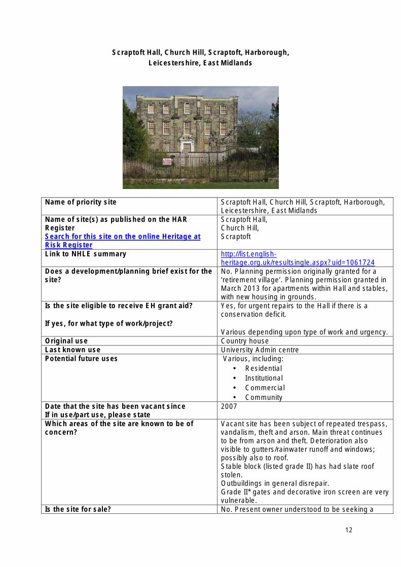
Scraptoft Hall, Church Hill, Scraptoft, Harborough, Leicestershire, East Midlands
Name of priority site Scraptoft Hall, Church Hill, Scraptoft, Harborough, Leicestershire, East Midlands
Name of site(s) as published on the HAR Register Search for this site on the online Heritage at Risk Register
Scraptoft Hall, Church Hill, Scraptoft
Link to NHLE summary http://list.englishheritage.org.uk/resultsingle.aspx?uid=1061724
Does a development/planning brief exist for the site?
No. Planning permission originally granted for a ‘retirement village’. Planning permission granted in March 2013 for apartments within Hall and stables, with new housing in grounds.
Is the site eligible to receive EH grant aid?
If yes, for what type of work/project?
Yes, for urgent repairs to the Hall if there is a conservation deficit.
Various depending upon type of work and urgency. Original use Country house Last known use University Admin centre Potential future uses Various, including:
• Residential • Institutional • Commercial • Community
Date that the site has been vacant since If in use/part use, please state
2007
Which areas of the site are known to be of concern?
Vacant site has been subject of repeated trespass, vandalism, theft and arson. Main threat continues to be from arson and theft. Deterioration also visible to gutters/rainwater runoff and windows; possibly also to roof. Stable block (listed grade II) has had slate roof stolen. Outbuildings in general disrepair. Grade II* gates and decorative iron screen are very vulnerable.
Is the site for sale? No. Present owner understood to be seeking a
12

development partner. Lead contact at the local planning authority Name: Emma Harrison
Number: 01858 828 282 Email address: [email protected] Local Authority: Harborough District Council
13
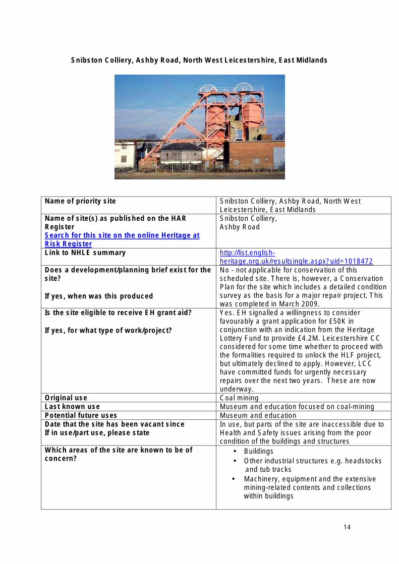
Snibston Colliery, Ashby Road, North West Leicestershire, East Midlands
Name of priority site Snibston Colliery, Ashby Road, North West Leicestershire, East Midlands
Name of site(s) as published on the HAR Register Search for this site on the online Heritage at Risk Register
Snibston Colliery, Ashby Road
Link to NHLE summary http://list.englishheritage.org.uk/resultsingle.aspx?uid=1018472
Does a development/planning brief exist for the site?
If yes, when was this produced
No - not applicable for conservation of this scheduled site. There is, however, a Conservation Plan for the site which includes a detailed condition survey as the basis for a major repair project. This was completed in March 2009.
Is the site eligible to receive EH grant aid?
If yes, for what type of work/project?
Yes. EH signalled a willingness to consider favourably a grant application for £50K in conjunction with an indication from the Heritage Lottery Fund to provide £4.2M. Leicestershire CC considered for some time whether to proceed with the formalities required to unlock the HLF project, but ultimately declined to apply. However, LCC have committed funds for urgently necessary repairs over the next two years. These are now underway.
Original use Coal mining Last known use Museum and education focused on coal-mining Potential future uses Museum and education Date that the site has been vacant since If in use/part use, please state
In use, but parts of the site are inaccessible due to Health and Safety issues arising from the poor condition of the buildings and structures
Which areas of the site are known to be of concern?
• Buildings • Other industrial structures e.g. headstocks
and tub tracks • Machinery, equipment and the extensive
mining-related contents and collections within buildings
14
Is the site for sale? No. Site in public ownership to secure repairs and maximise educational and community benefits.
Lead contact at the local planning authority Name: Carolyn Abel (Principal Curator) Number: 0116 305 3468 Email address: [email protected] Local Authority: Leicestershire County Council
15
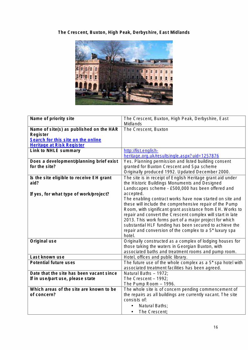
The Crescent, Buxton, High Peak, Derbyshire, East Midlands
Name of priority site The Crescent, Buxton, High Peak, Derbyshire, East Midlands
Name of site(s) as published on the HAR Register Search for this site on the online Heritage at Risk Register
The Crescent, Buxton
Link to NHLE summary http://list.englishheritage.org.uk/resultsingle.aspx?uid=1257876
Does a development/planning brief exist for the site?
Yes. Planning permission and listed building consent granted for Buxton Crescent and Spa scheme Originally produced 1992. Updated December 2000.
Is the site eligible to receive EH grant aid?
If yes, for what type of work/project?
The site is in receipt of English Heritage grant aid under the Historic Buildings Monuments and Designed Landscapes scheme - £500,000 has been offered and accepted. The enabling contract works have now started on site and these will include the comprehensive repair of the Pump Room, with significant grant assistance from EH. Works to repair and convert the Crescent complex will start in late 2013. This work forms part of a major project for which substantial HLF funding has been secured to achieve the repair and conversion of the complex to a 5* luxury spa hotel.
Original use Originally constructed as a complex of lodging houses for those taking the waters in Georgian Buxton, with associated baths and treatment rooms and pump room.
Last known use Hotel, offices and public library. Potential future uses The future use of the whole complex as a 5* spa hotel with
associated treatment facilities has been agreed. Date that the site has been vacant since If in use/part use, please state
Natural Baths – 1972; The Crescent – 1992; The Pump Room – 1996.
Which areas of the site are known to be of concern?
The whole site is of concern pending commencement of the repairs as all buildings are currently vacant. The site consists of:
• Natural Baths; • The Crescent;
16

• The Pump Room. Is the site for sale? No. Development Agreements are in place. Lead contact at the local planning authority
Name: Mr Richard Tuffrey Number: 0845 129 7777 ext 3653 Email address: [email protected] Local Authority: High Peak Borough Council
17
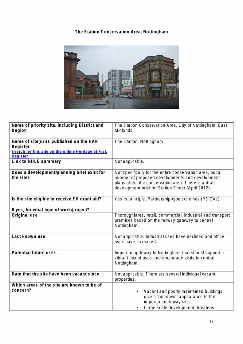
The Station Conservation Area, Nottingham
Name of priority site, including District and Region
The Station Conservation Area, City of Nottingham, East Midlands
Name of site(s) as published on the HAR Register Search for this site on the online Heritage at Risk Register
The Station, Nottingham
Link to NHLE summary Not applicable.
Does a development/planning brief exist for the site?
Not specifically for the entire conservation area, but a number of proposed developments and development plans affect the conservation area. There is a draft development brief for Station Street (April 2012).
Is the site eligible to receive EH grant aid?
If yes, for what type of work/project?
Yes in principle. Partnership-type schemes (PSiCAs).
Original use Thoroughfares, retail, commercial, industrial and transport premises based on the railway gateway to central Nottingham.
Last known use Not applicable. Industrial uses have declined and office uses have increased.
Potential future uses Important gateway to Nottingham that should support a vibrant mix of uses and encourage visits to central Nottingham.
Date that the site have been vacant since Not applicable. There are several individual vacant properties.
Which areas of the site are known to be of concern? • Vacant and poorly maintained buildings
give a ‘run down’ appearance to this important gateway site.
• Large scale development threatens
18
individual historic buildings and the character of the area.
• Levelled sites create huge gaps in street frontages.
• Busy roads create hostile pedestrian environment and inhibit appreciation of the area.
• The Station Conservation Area is intertwined with the Canal Conservation Area, which suffers the same issues (for example, on the adjoining Carrington Street).
• The site is abutted by the Broadmarsh Centre, the redevelopment of which has been a focus of three Urban Panel visits and a presentation to English Heritage’s Advisory Committee.
Is the site for sale? Not in its entirety. Individual sites and premises are for sale.
Lead contact at the local planning authority Name: Nigel Turpin, Heritage and Urban Design Manager Number: 0115 8764081 Email address: [email protected] Local Authority: Nottingham City Council
19
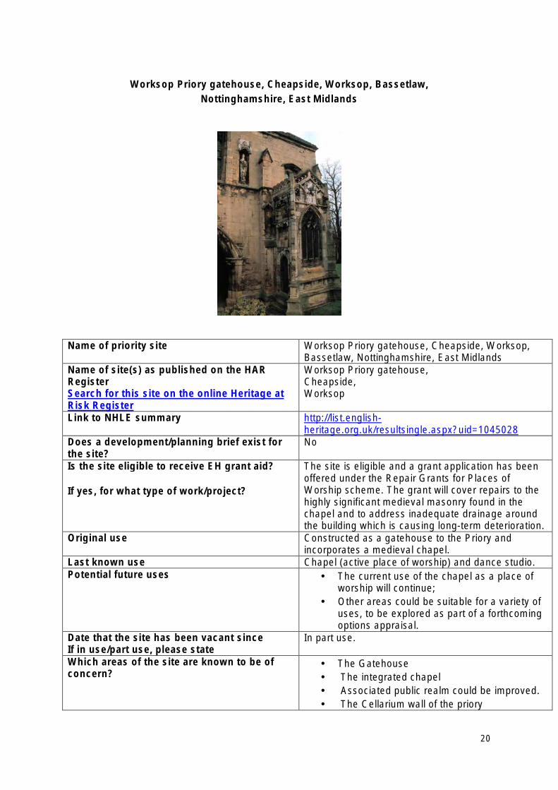
Worksop Priory gatehouse, Cheapside, Worksop, Bassetlaw, Nottinghamshire, East Midlands
Name of priority site Worksop Priory gatehouse, Cheapside, Worksop, Bassetlaw, Nottinghamshire, East Midlands
Name of site(s) as published on the HAR Register Search for this site on the online Heritage at Risk Register
Worksop Priory gatehouse, Cheapside, Worksop
Link to NHLE summary http://list.englishheritage.org.uk/resultsingle.aspx?uid=1045028
Does a development/planning brief exist for the site?
No
Is the site eligible to receive EH grant aid?
If yes, for what type of work/project?
The site is eligible and a grant application has been offered under the Repair Grants for Places of Worship scheme. The grant will cover repairs to the highly significant medieval masonry found in the chapel and to address inadequate drainage around the building which is causing long-term deterioration.
Original use Constructed as a gatehouse to the Priory and incorporates a medieval chapel.
Last known use Chapel (active place of worship) and dance studio. Potential future uses • The current use of the chapel as a place of
worship will continue; • Other areas could be suitable for a variety of
uses, to be explored as part of a forthcoming options appraisal.
Date that the site has been vacant since If in use/part use, please state
In part use.
Which areas of the site are known to be of concern?
• The Gatehouse • The integrated chapel • Associated public realm could be improved. • The Cellarium wall of the priory
20

Is the site for sale? No. A Trust has been established with a view to securing sustainable future use and management of the Priory Gatehouse.
Lead contact at the local planning authority Name: Mr Simon Britt Number: 01909 533427 Email address: [email protected] Local Authority: Bassetlaw District Council
21
East of England Heritage at Risk Priority Sites 2013
• Chantry Chapel and Mausoleum, Thorndon Park, Brentwood, Essex
• Church of St Mary the Virgin (Old Parish Church), Clophill, Bedfordshire
• Croxley Great Barn, Three Rivers, Hertfordshire
• Knebworth House, Knebworth, Hertfordshire
• Langham Airfield Dome Trainer, Langham, Norfolk
• Pentney Priory Gatehouse, Pentney, Norfolk
• Remains of Sibton Abbey, Suffolk Coastal, Suffolk
• Remains of St Mary’s Friary, Little Walsingham, Norfolk
• St Osyth’s Priory, St Osyth, Tendring, Essex
• Tilty Mill, Tilty, Essex
22
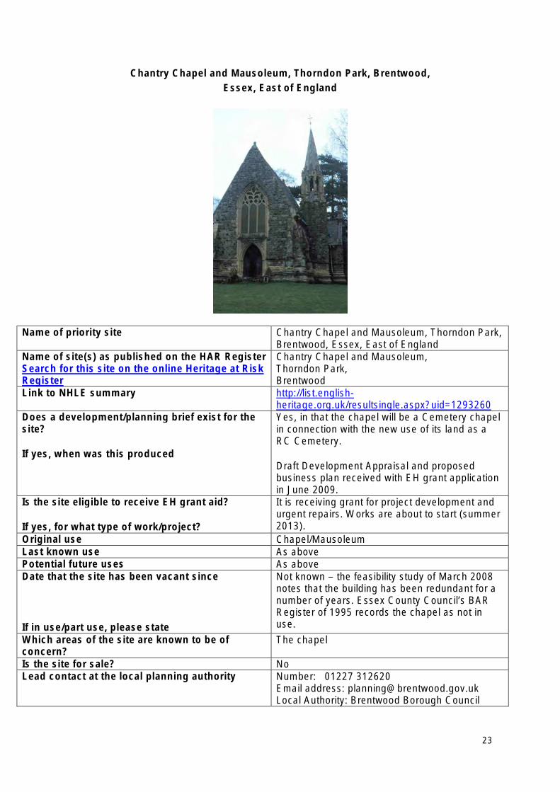
Chantry Chapel and Mausoleum, Thorndon Park, Brentwood, Essex, East of England
Name of priority site Chantry Chapel and Mausoleum, Thorndon Park, Brentwood, Essex, East of England
Name of site(s) as published on the HAR Register Search for this site on the online Heritage at Risk Register
Chantry Chapel and Mausoleum, Thorndon Park, Brentwood
Link to NHLE summary http://list.englishheritage.org.uk/resultsingle.aspx?uid=1293260
Does a development/planning brief exist for the site?
If yes, when was this produced
Yes, in that the chapel will be a Cemetery chapel in connection with the new use of its land as a RC Cemetery.
Draft Development Appraisal and proposed business plan received with EH grant application in June 2009.
Is the site eligible to receive EH grant aid?
If yes, for what type of work/project?
It is receiving grant for project development and urgent repairs. Works are about to start (summer 2013).
Original use Chapel/Mausoleum Last known use As above Potential future uses As above Date that the site has been vacant since
If in use/part use, please state
Not known – the feasibility study of March 2008 notes that the building has been redundant for a number of years. Essex County Council’s BAR Register of 1995 records the chapel as not in use.
Which areas of the site are known to be of concern?
The chapel
Is the site for sale? No Lead contact at the local planning authority Number: 01227 312620
Email address: [email protected] Local Authority: Brentwood Borough Council
23
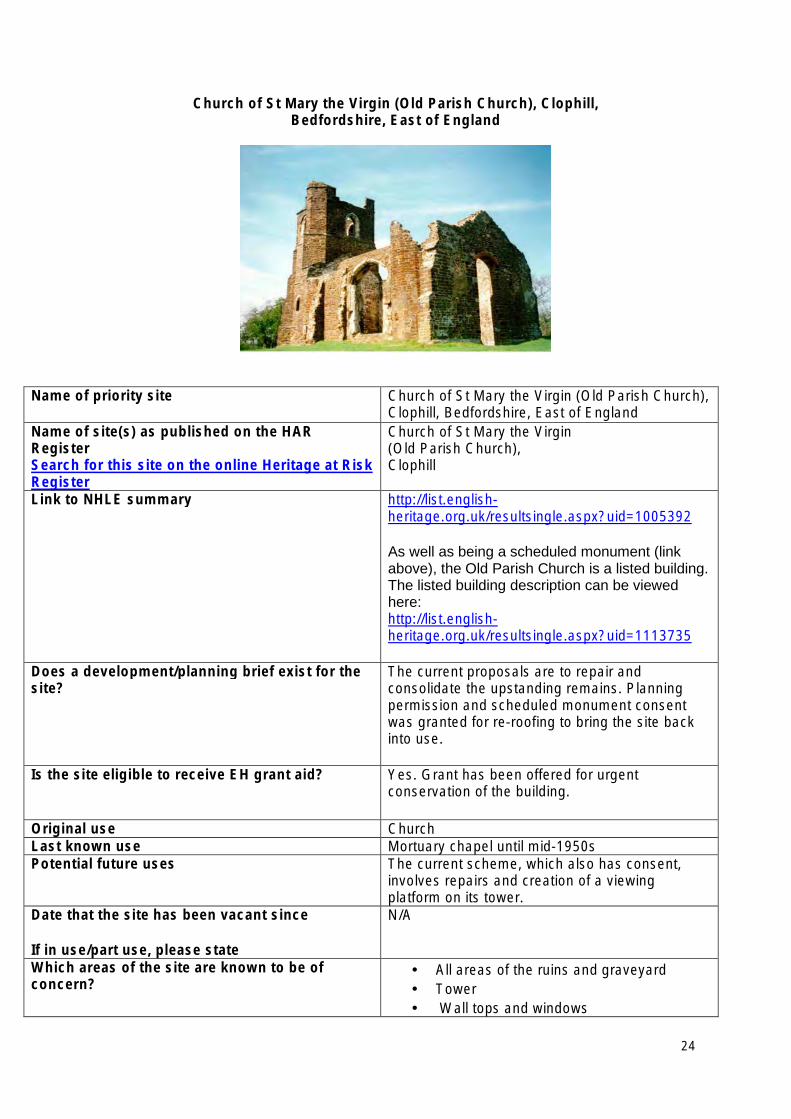
Church of St Mary the Virgin (Old Parish Church), Clophill, Bedfordshire, East of England
Name of priority site Church of St Mary the Virgin (Old Parish Church), Clophill, Bedfordshire, East of England
Name of site(s) as published on the HAR Register Search for this site on the online Heritage at Risk Register
Church of St Mary the Virgin (Old Parish Church), Clophill
Link to NHLE summary http://list.englishheritage.org.uk/resultsingle.aspx?uid=1005392
As well as being a scheduled monument (link above), the Old Parish Church is a listed building. The listed building description can be viewed here: http://list.englishheritage.org.uk/resultsingle.aspx?uid=1113735
Does a development/planning brief exist for the site?
The current proposals are to repair and consolidate the upstanding remains. Planning permission and scheduled monument consent was granted for re-roofing to bring the site back into use.
Is the site eligible to receive EH grant aid? Yes. Grant has been offered for urgent conservation of the building.
Original use Church Last known use Mortuary chapel until mid-1950s Potential future uses The current scheme, which also has consent,
involves repairs and creation of a viewing platform on its tower.
Date that the site has been vacant since
If in use/part use, please state
N/A
Which areas of the site are known to be of concern?
• All areas of the ruins and graveyard • Tower • Wall tops and windows
24
Is the site for sale? No
Lead contact at the local planning authority Name: Richard Ellis Number:0300 300 4423 Email address: [email protected] Local Authority: Central Bedfordshire Council
25
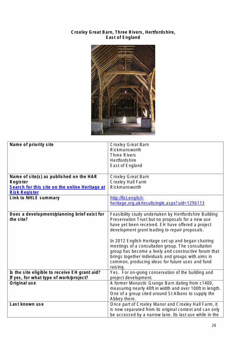
Croxley Great Barn, Three Rivers, Hertfordshire, East of England
Name of priority site Croxley Great Barn Rickmansworth Three Rivers Hertfordshire East of England
Name of site(s) as published on the HAR Register Search for this site on the online Heritage at Risk Register
Croxley Great Barn Croxley Hall Farm Rickmansworth
Link to NHLE summary http://list.englishheritage.org.uk/resultsingle.aspx?uid=1296113
Does a development/planning brief exist for the site?
Feasibility study undertaken by Hertfordshire Building Preservation Trust but no proposals for a new use have yet been received. EH have offered a project development grant leading to repair proposals.
In 2012 English Heritage set up and began chairing meetings of a consultation group. The consultation group has become a lively and constructive forum that brings together individuals and groups with aims in common, producing ideas for future uses and fund raising.
Is the site eligible to receive EH grant aid? If yes, for what type of work/project?
Yes. For on-going conservation of the building and project development.
Original use A former Monastic Grange Barn dating from c1400, measuring nearly 40ft in width and over 100ft in length. One of a group sited around St Albans to supply the Abbey there.
Last known use Once part of Croxley Manor and Croxley Hall Farm, it is now separated from its original context and can only be accessed by a narrow lane. Its last use while in the
26
ownership of a neighbouring school was as a store for redundant equipment and furniture.
Potential future uses Commercial visitor attraction/events Exhibitions and arts/theatre Commercial conference uses Offices Training venue Heritage display and demonstrations Education visits
Date that the site has been vacant since If in use/part use, please state
1970s
Which areas of the site are known to be of concern?
In poor condition for decades, a general lack of maintenance resulted in progressive deterioration again, with concerns including damp penetration and failure of roof tile fixings.
Is the site for sale? No Lead contact at the local planning authority Name: Steve Farrell
Number: 01923 776611 Email address: [email protected] Local Authority: Three Rivers District Council
27
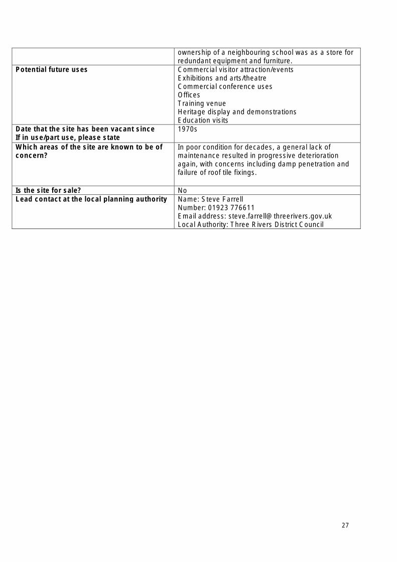
Knebworth House, Knebworth, Hertfordshire, East of England
Name of priority site Knebworth House, Knebworth, Hertfordshire, East of England
Name of site(s) as published on the HAR Register Search for this site on the online Heritage at Risk Register
Knebworth House, Knebworth, Hertfordshire
Link to NHLE summary http://list.englishheritage.org.uk/resultsingle.aspx?uid=1102767
Does a development/planning brief exist for the site? If yes, when was this produced (please provide month and year)?
No.
Is the site eligible to receive EH grant aid?
If yes, for what type of work/project?
Grant aid - Major repairs to half of the building were funded by grant aid in the late 1990s. A further grant was offered in 2013 towards a further, more limited, phase. This would entail the repair of a further section of the roof over the main range and repairs to the render. The project will include recording. Its estimated cost is £240,000.
Current project includes repairs to render and upper level detailing. Repairs to main roof covering and repairs to the structure and cladding of two pinnacles. Monitoring, recording and a final report. Estimated costs: £240,000.
Original use (if known, if not known, please state first known use)
Residential
Last known use Knebworth continues in use as a house but is also open as a major visitor attraction.
Potential future uses • Residential • Commercial Visitor attraction/events • Commercial conference uses
Date that the site has been vacant since (month and year). If in use/part use, please state
Occupied residential and open to public
Which areas of the site are known to be of concern? Central west façade Is the site for sale? No Lead contact at the local planning authority Name: Liz Marten
Number: 01462 474000 Email address: [email protected] Local Authority: North Hertfordshire District Council
28
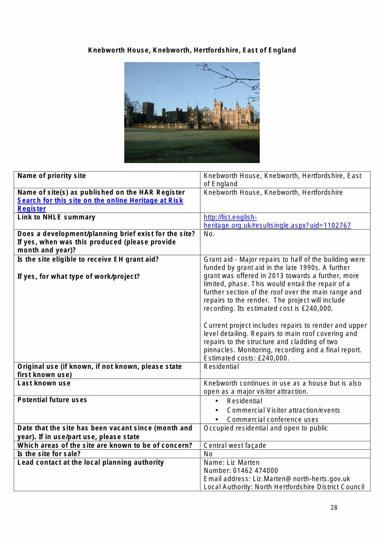
Langham Airfield Dome Trainer, Langham, Norfolk, East of England
Name of priority site Langham Airfield Dome Trainer, Langham, Norfolk, East of England
Name of site(s) as published on the HAR Register Search for this site on the online Heritage at Risk Register
Langham Airfield Dome Trainer, Langham
Link to NHLE summary http://list.englishheritage.org.uk/resultsingle.aspx?uid=1003173
Does a development/planning brief exist for the site?
If yes, when was this produced
Yes. Draft proposal for stage 1 HLF application successful March 2011.
Stage 2 application made by end of 2012. Is the site eligible to receive EH grant aid? Yes. Grant offered March 2004 for fabric repair of
concrete shell, repair of internal lining and partitions, security measures, and recording. Grant increased to £325,000 and project due to commence in September 2013.
Original use RAF training in AA Gunnery.
Last known use Unused since WW2.
Potential future uses • Heritage display and demonstrations • Education visits • Friends Activities
Date that the site has been vacant since
If in use/part use, please state
Since 1952 when adjacent airfield closed.
Which areas of the site are known to be of concern?
Concern relates to the continuing degradation of the fabric of the concrete shell.
Is the site for sale? No. Currently owned by Norfolk Historic Buildings Preservation Trust.
Lead contact at the local planning authority Name: Philip Godwin Number: 01263 516131 Email address: [email protected] Local Authority: North Norfolk District Council
29
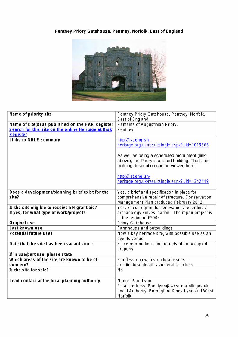
Pentney Priory Gatehouse, Pentney, Norfolk, East of England
Name of priority site Pentney Priory Gatehouse, Pentney, Norfolk, East of England
Name of site(s) as published on the HAR Register Search for this site on the online Heritage at Risk Register
Remains of Augustinian Priory, Pentney
Links to NHLE summary http://list.englishheritage.org.uk/resultsingle.aspx?uid=1019666
As well as being a scheduled monument (link above), the Priory is a listed building. The listed building description can be viewed here:
http://list.englishheritage.org.uk/resultsingle.aspx?uid=1342419
Does a development/planning brief exist for the site?
Yes, a brief and specification in place for comprehensive repair of structure. Conservation Management Plan produced February 2013.
Is the site eligible to receive EH grant aid? If yes, for what type of work/project?
Yes. Secular grant for renovation / recording / archaeology / investigation. The repair project is in the region of £500k
Original use Priory Gatehouse Last known use Farmhouse and outbuildings Potential future uses Now a key heritage site, with possible use as an
events venue. Date that the site has been vacant since
If in use/part use, please state
Since reformation – in grounds of an occupied property.
Which areas of the site are known to be of concern?
Roofless ruin with structural issues – architectural detail is vulnerable to loss.
Is the site for sale? No
Lead contact at the local planning authority Name: Pam Lynn Email address: [email protected] Local Authority: Borough of Kings Lynn and West Norfolk
30
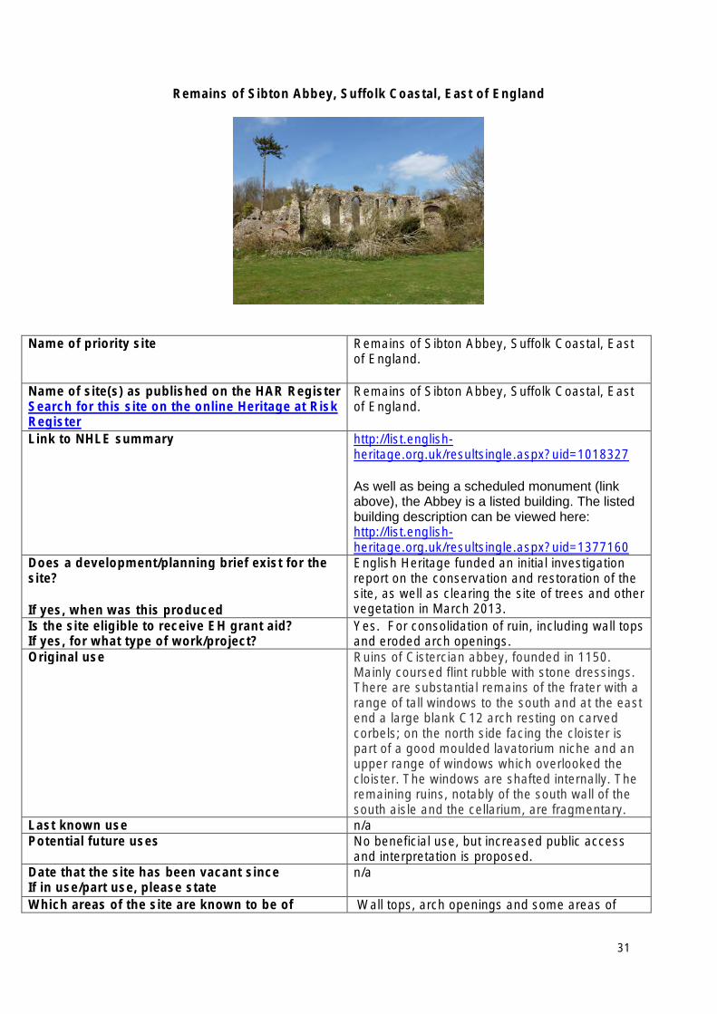
Remains of Sibton Abbey, Suffolk Coastal, East of England
Name of priority site Remains of Sibton Abbey, Suffolk Coastal, East of England.
Name of site(s) as published on the HAR Register Search for this site on the online Heritage at Risk Register
Remains of Sibton Abbey, Suffolk Coastal, East of England.
Link to NHLE summary http://list.englishheritage.org.uk/resultsingle.aspx?uid=1018327
As well as being a scheduled monument (link above), the Abbey is a listed building. The listed building description can be viewed here: http://list.englishheritage.org.uk/resultsingle.aspx?uid=1377160
Does a development/planning brief exist for the site?
If yes, when was this produced
English Heritage funded an initial investigation report on the conservation and restoration of the site, as well as clearing the site of trees and other vegetation in March 2013.
Is the site eligible to receive EH grant aid? If yes, for what type of work/project?
Yes. For consolidation of ruin, including wall tops and eroded arch openings.
Original use Ruins of Cistercian abbey, founded in 1150. Mainly coursed flint rubble with stone dressings. There are substantial remains of the frater with a range of tall windows to the south and at the east end a large blank C12 arch resting on carved corbels; on the north side facing the cloister is part of a good moulded lavatorium niche and an upper range of windows which overlooked the cloister. The windows are shafted internally. The remaining ruins, notably of the south wall of the south aisle and the cellarium, are fragmentary.
Last known use n/a Potential future uses No beneficial use, but increased public access
and interpretation is proposed. Date that the site has been vacant since If in use/part use, please state
n/a
Which areas of the site are known to be of Wall tops, arch openings and some areas of
31
concern? collapsing flint wall. Is the site for sale? No
Lead contact at the local planning authority Name: Robert Scrimgeour Number: 01394 444616 Email address: [email protected] Local Authority: Suffolk Coastal
32
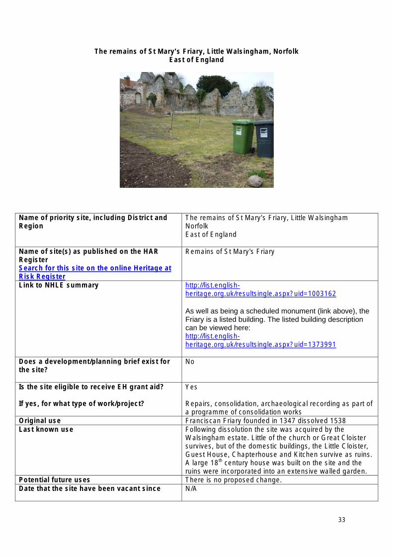
The remains of St Mary’s Friary, Little Walsingham, Norfolk East of England
Name of priority site, including District and Region
The remains of St Mary’s Friary, Little Walsingham Norfolk East of England
Name of site(s) as published on the HAR Register Search for this site on the online Heritage at Risk Register
Remains of St Mary's Friary
Link to NHLE summary http://list.englishheritage.org.uk/resultsingle.aspx?uid=1003162
As well as being a scheduled monument (link above), the Friary is a listed building. The listed building description can be viewed here: http://list.englishheritage.org.uk/resultsingle.aspx?uid=1373991
Does a development/planning brief exist for the site?
No
Is the site eligible to receive EH grant aid?
If yes, for what type of work/project?
Yes
Repairs, consolidation, archaeological recording as part of a programme of consolidation works
Original use Franciscan Friary founded in 1347 dissolved 1538 Last known use Following dissolution the site was acquired by the
Walsingham estate. Little of the church or Great Cloister survives, but of the domestic buildings, the Little Cloister, Guest House, Chapterhouse and Kitchen survive as ruins. A large 18th century house was built on the site and the ruins were incorporated into an extensive walled garden.
Potential future uses There is no proposed change. Date that the site have been vacant since N/A
33

Which areas of the site are known to be of concern?
Little Cloister, Guest House, Chapterhouse and Kitchen
Is the site for sale? No Lead contact at the local planning authority Name: Conservation and Design team
Number: 01263 516165 Email address: conservationanddesign@northnorfolk.gov.uk Local Authority: North Norfolk District Council.
34
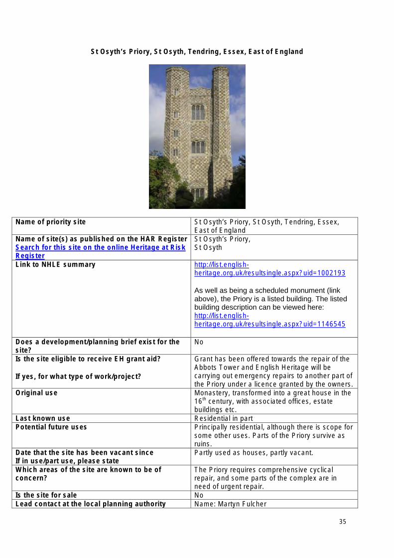
St Osyth’s Priory, St Osyth, Tendring, Essex, East of England
Name of priority site St Osyth’s Priory, St Osyth, Tendring, Essex, East of England
Name of site(s) as published on the HAR Register Search for this site on the online Heritage at Risk Register
St Osyth’s Priory, St Osyth
Link to NHLE summary http://list.englishheritage.org.uk/resultsingle.aspx?uid=1002193
As well as being a scheduled monument (link above), the Priory is a listed building. The listed building description can be viewed here: http://list.englishheritage.org.uk/resultsingle.aspx?uid=1146545
Does a development/planning brief exist for the site?
No
Is the site eligible to receive EH grant aid?
If yes, for what type of work/project?
Grant has been offered towards the repair of the Abbots Tower and English Heritage will be carrying out emergency repairs to another part of the Priory under a licence granted by the owners.
Original use Monastery, transformed into a great house in the 16th century, with associated offices, estate buildings etc.
Last known use Residential in part Potential future uses Principally residential, although there is scope for
some other uses. Parts of the Priory survive as ruins.
Date that the site has been vacant since If in use/part use, please state
Partly used as houses, partly vacant.
Which areas of the site are known to be of concern?
The Priory requires comprehensive cyclical repair, and some parts of the complex are in need of urgent repair.
Is the site for sale No Lead contact at the local planning authority Name: Martyn Fulcher
35
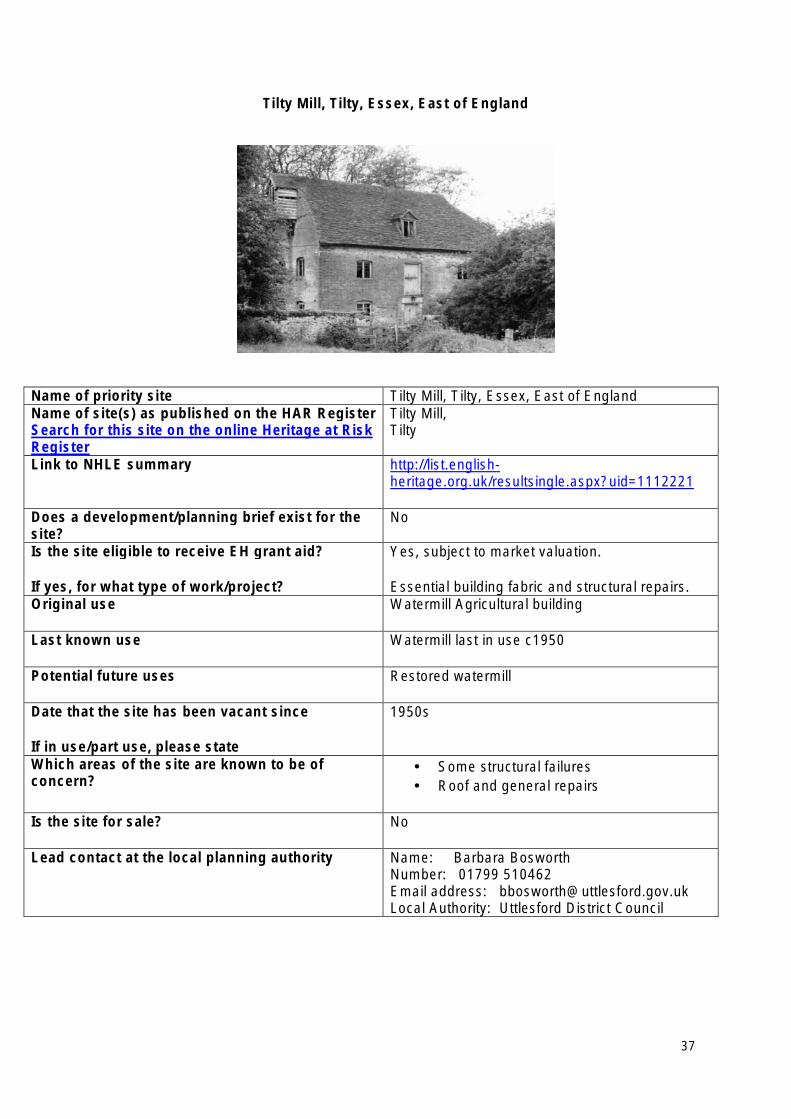
Tilty Mill, Tilty, Essex, East of England
Name of priority site Tilty Mill, Tilty, Essex, East of England Name of site(s) as published on the HAR Register Search for this site on the online Heritage at Risk Register
Tilty Mill, Tilty
Link to NHLE summary http://list.englishheritage.org.uk/resultsingle.aspx?uid=1112221
Does a development/planning brief exist for the site?
No
Is the site eligible to receive EH grant aid?
If yes, for what type of work/project?
Yes, subject to market valuation.
Essential building fabric and structural repairs. Original use Watermill Agricultural building
Last known use Watermill last in use c1950
Potential future uses Restored watermill
Date that the site has been vacant since
If in use/part use, please state
1950s
Which areas of the site are known to be of concern?
• Some structural failures • Roof and general repairs
Is the site for sale? No
Lead contact at the local planning authority Name: Barbara Bosworth Number: 01799 510462 Email address: [email protected] Local Authority: Uttlesford District Council
37
London Heritage at Risk Priority Sites 2013
• Abney Park Cemetery (including the mortuary chapel, monument to Joanna Vassa and monument to John Swain), Hackney
• Crossways, 134 Church Road, Hanwell, Ealing
• Finsbury Health Centre, Pine Street, Islington
• Gunnersbury Park (including the west and east stables, the large and small mansions and other structures), Hounslow
• Hanwell flight of locks and brick boundary wall of St Bernard’s Hospital, Ealing
• Kensal Green (All Souls) Cemetery (including the Anglican Chapel, a number of monuments and other structures), Kensington and Chelsea
• Manor Farm barn, High Street, Harmondsworth, Hillingdon
• Tide Mill (known as the House Mill), Three Mill Lane, Newham
• Whitechapel High Street Conservation Area (High Street 2012), Tower Hamlets
• 94 Piccadilly, Westminster
38
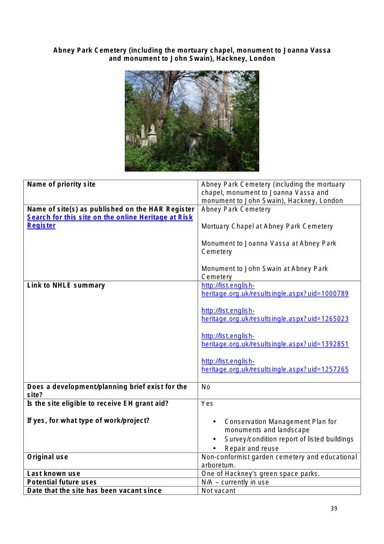
Abney Park Cemetery (including the mortuary chapel, monument to Joanna Vassa and monument to John Swain), Hackney, London
Name of priority site Abney Park Cemetery (including the mortuary chapel, monument to Joanna Vassa and monument to John Swain), Hackney, London
Name of site(s) as published on the HAR Register Search for this site on the online Heritage at Risk Register
Abney Park Cemetery
Mortuary Chapel at Abney Park Cemetery
Monument to Joanna Vassa at Abney Park Cemetery
Monument to John Swain at Abney Park Cemetery
Link to NHLE summary http://list.englishheritage.org.uk/resultsingle.aspx?uid=1000789
http://list.englishheritage.org.uk/resultsingle.aspx?uid=1265023
http://list.englishheritage.org.uk/resultsingle.aspx?uid=1392851
http://list.englishheritage.org.uk/resultsingle.aspx?uid=1257265
Does a development/planning brief exist for the site?
No
Is the site eligible to receive EH grant aid?
If yes, for what type of work/project?
Yes
• Conservation Management Plan for monuments and landscape
• Survey/condition report of listed buildings • Repair and reuse
Original use Non-conformist garden cemetery and educational arboretum.
Last known use One of Hackney’s green space parks. Potential future uses N/A – currently in use Date that the site has been vacant since Not vacant
39
If in use/part use, please state In use as a nature reserve, green space/park with education programmes and some courtesy burials.
Which areas of the site are known to be of concern?
• Mortuary Chapel listed at grade II • Condition of the Registered Park and
Garden grade II • Listed monuments
Is the site for sale? No
Lead contact at the local planning authority Name: Rodney Keg Manager – Urban Design Conservation and Sustainability Number: 020 8356 7739 Email address: [email protected] Local Authority: London Borough of Hackney
40
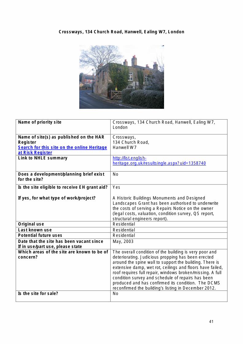
Crossways, 134 Church Road, Hanwell, Ealing W7, London
Name of priority site Crossways, 134 Church Road, Hanwell, Ealing W7, London
Name of site(s) as published on the HAR Register Search for this site on the online Heritage at Risk Register
Crossways, 134 Church Road, Hanwell W7
Link to NHLE summary http://list.englishheritage.org.uk/resultsingle.aspx?uid=1358740
Does a development/planning brief exist for the site?
No
Is the site eligible to receive EH grant aid?
If yes, for what type of work/project?
Yes
A Historic Buildings Monuments and Designed Landscapes Grant has been authorised to underwrite the costs of serving a Repairs Notice on the owner (legal costs, valuation, condition survey, QS report, structural engineers report).
Original use Residential Last known use Residential Potential future uses Residential Date that the site has been vacant since If in use/part use, please state
May, 2003
Which areas of the site are known to be of concern?
The overall condition of the building is very poor and deteriorating. Judicious propping has been erected around the spine wall to support the building. There is extensive damp, wet rot, ceilings and floors have failed, roof requires full repair, windows broken/missing. A full condition survey and schedule of repairs has been produced and has confirmed its condition. The DCMS reconfirmed the building’s listing in December 2012.
Is the site for sale? No
41

Lead contact at the local planning Name: Rosemarie Wakelin authority Number: 0208 825 5000
Email address: [email protected] Local Authority: LB Ealing
42
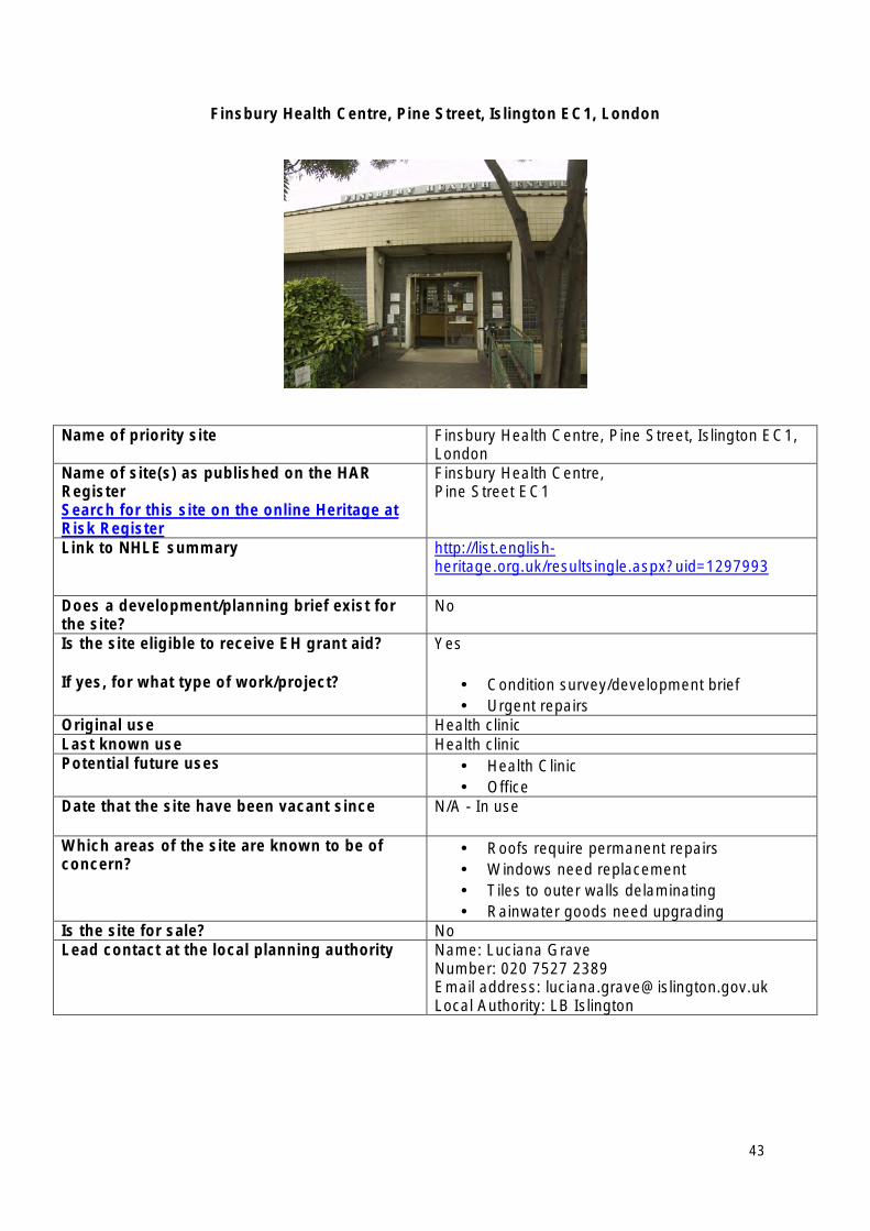
Finsbury Health Centre, Pine Street, Islington EC1, London
Name of priority site Finsbury Health Centre, Pine Street, Islington EC1, London
Name of site(s) as published on the HAR Register Search for this site on the online Heritage at Risk Register
Finsbury Health Centre, Pine Street EC1
Link to NHLE summary http://list.englishheritage.org.uk/resultsingle.aspx?uid=1297993
Does a development/planning brief exist for the site?
No
Is the site eligible to receive EH grant aid?
If yes, for what type of work/project?
Yes
• Condition survey/development brief • Urgent repairs
Original use Health clinic Last known use Health clinic Potential future uses • Health Clinic
• Office Date that the site have been vacant since N/A - In use
Which areas of the site are known to be of concern?
• Roofs require permanent repairs • Windows need replacement • Tiles to outer walls delaminating • Rainwater goods need upgrading
Is the site for sale? No Lead contact at the local planning authority Name: Luciana Grave
Number: 020 7527 2389 Email address: [email protected] Local Authority: LB Islington
43
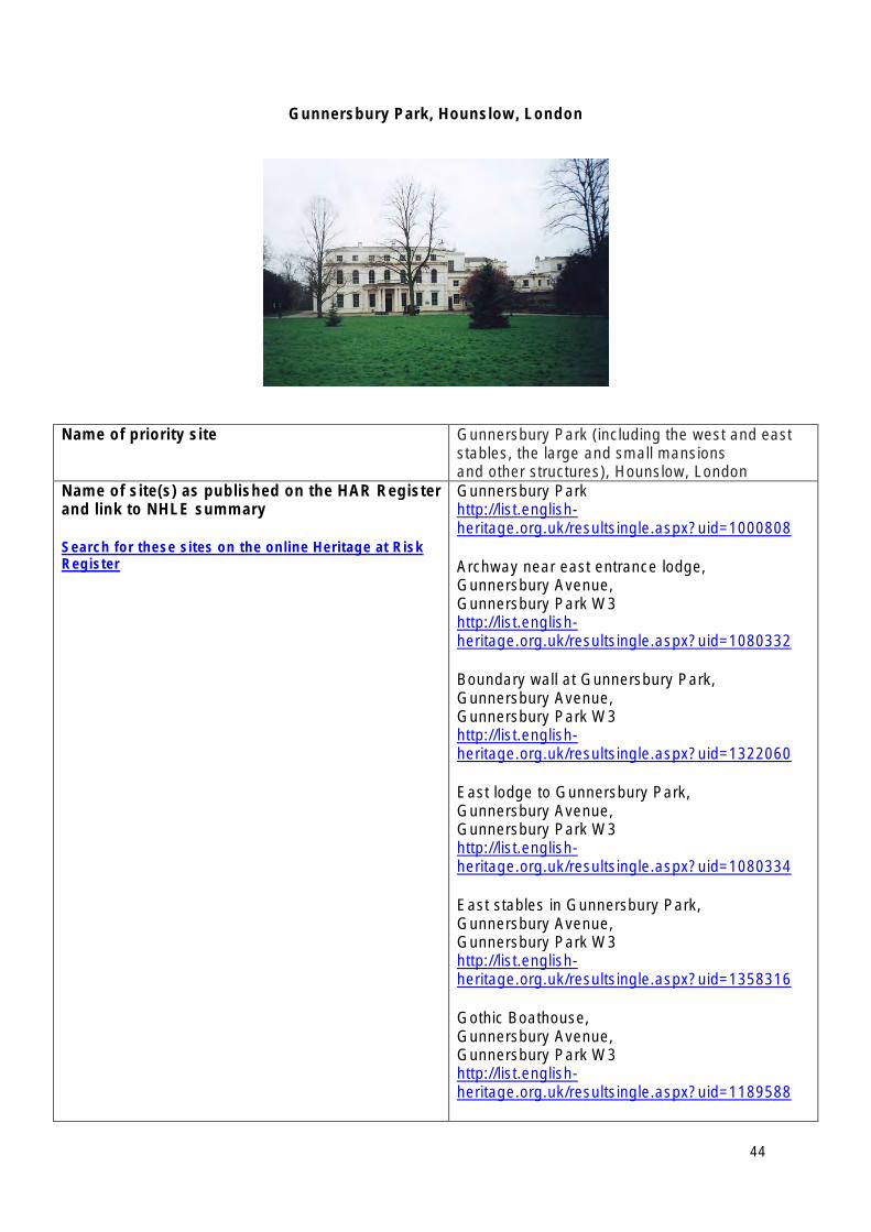
Gunnersbury Park, Hounslow, London
Name of priority site Gunnersbury Park (including the west and east stables, the large and small mansions and other structures), Hounslow, London
Name of site(s) as published on the HAR Register Gunnersbury Park and link to NHLE summary http://list.english
heritage.org.uk/resultsingle.aspx?uid=1000808 Search for these sites on the online Heritage at Risk Register Archway near east entrance lodge,
Gunnersbury Avenue, Gunnersbury Park W3 http://list.englishheritage.org.uk/resultsingle.aspx?uid=1080332
Boundary wall at Gunnersbury Park, Gunnersbury Avenue, Gunnersbury Park W3 http://list.englishheritage.org.uk/resultsingle.aspx?uid=1322060
East lodge to Gunnersbury Park, Gunnersbury Avenue, Gunnersbury Park W3 http://list.englishheritage.org.uk/resultsingle.aspx?uid=1080334
East stables in Gunnersbury Park, Gunnersbury Avenue, Gunnersbury Park W3 http://list.englishheritage.org.uk/resultsingle.aspx?uid=1358316
Gothic Boathouse, Gunnersbury Avenue, Gunnersbury Park W3 http://list.englishheritage.org.uk/resultsingle.aspx?uid=1189588
44
Gothic ruins in Gunnersbury Park, Gunnersbury Avenue, Gunnersbury Park W3 http://list.englishheritage.org.uk/resultsingle.aspx?uid=1080335
North Lodge, Gunnersbury Avenue, Gunnersbury Park W3 http://list.englishheritage.org.uk/resultsingle.aspx?uid=1294205
The Large Mansion, Gunnersbury Park House, Gunnersbury Avenue, Gunnersbury Park W3 http://list.englishheritage.org.uk/resultsingle.aspx?uid=1358312
The Small Mansion, Gunnersbury House, Gunnersbury Avenue, Gunnersbury Park W3 http://list.englishheritage.org.uk/resultsingle.aspx?uid=1080330
West Lodge and arch, Gunnersbury Avenue, Gunnersbury Park W3 http://list.englishheritage.org.uk/resultsingle.aspx?uid=1389619
West stable block in Gunnersbury Park, Gunnersbury Avenue, Gunnersbury Park W3 http://list.englishheritage.org.uk/resultsingle.aspx?uid=1096950
Does a development/planning brief exist for the site?
Conservation Management Plan compiled in June 2008 by Chris Blandford Associates
Is the site eligible to receive EH grant aid? Yes
If yes, for what type of work/project? • Condition surveys – grant taken up in 2011 for survey of 18 different listed buildings and structures on site.
• Repairs to individual buildings – grant work completed in autumn 2012 for essential repairs to Large Mansion, Small Mansion, West Lodge, North Lodge, East Lodge and adjacent archway.
• Grant offered in 2013 for works to repair and renew scaffolding supports to Stables.
• Repairs to Stables – provision of safe
45
access and consolidation of structures.
Original use Two stately homes and associated pleasure gardens/grounds and structures
Last known use As existing – public park with local museum. All buildings on HAR either vacant or have had no formal use – exception being the stables, which were used for grounds maintenance.
Potential future uses • Park to remain as public park – HLF Parks For People Stage 1 bid passed in June 2012 for restoration and reinstatement of the historic core of the parkland. Bid includes reuse of the Orangery and Temple for events/catering/educational use.
• Museum in Large Mansion - HLF Heritage Grant Stage 1 bid passed in July 2012 for refurbishment/repairs and reuse as museum with flexibility for additional use for functions.
• External envelope of North Lodge repaired with EH grant funding. Awaiting new community use.
• Roof of West Lodge repaired and building partly occupied for residential use. Awaiting further occupation.
• Still to establish future uses for Small Mansion, Stables, Princess Amelia’s Bathhouse and Potomac Tower.
Date that the site has been vacant since
If in use/part use, please state
Some buildings partly in use. Others have not been formally used since the estate was taken into public ownership.
Which areas of the site are known to be of concern?
• Condition of the buildings – due to recent EH grant funded works, many of the buildings on the site are in a stable condition in the short term. However, the Stables are known to be in a perilous state and it is expected that urgent works of consolidation and repair are due to start in the near future.
• Securing new and appropriate uses for the buildings – bearing in mind their public ownership, location within a public park with limited access and minimal curtilage land for parking or private gardens.
Is the site for sale? No. However, the owners would be likely to give consideration to any approaches by potential users for the Small Mansion, Stables, Princess Amelia’s Bathhouse and Potomac Tower.
46

Contact details Name: Bridget Gregory (Ealing Project Manager) Number: 020 8825 9681 Email address: [email protected]
Lead contact at the local planning authority Name: Maggie Urquhart Number: 020 8583 4941 Email address: [email protected] Local Authority: Hounslow
47
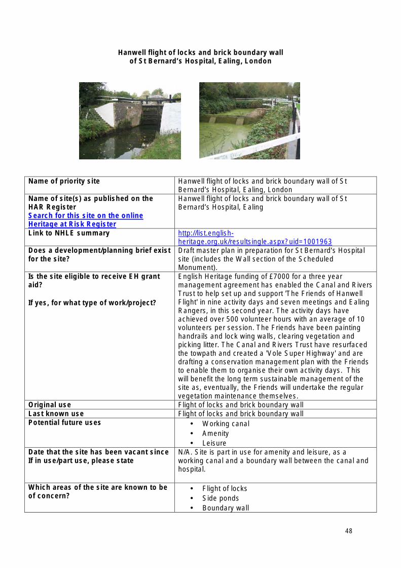
Hanwell flight of locks and brick boundary wall of St Bernard’s Hospital, Ealing, London
Name of priority site Hanwell flight of locks and brick boundary wall of St Bernard’s Hospital, Ealing, London
Name of site(s) as published on the HAR Register Search for this site on the online Heritage at Risk Register
Hanwell flight of locks and brick boundary wall of St Bernard’s Hospital, Ealing
Link to NHLE summary http://list.englishheritage.org.uk/resultsingle.aspx?uid=1001963
Does a development/planning brief exist for the site?
Draft master plan in preparation for St Bernard’s Hospital site (includes the Wall section of the Scheduled Monument).
Is the site eligible to receive EH grant aid?
If yes, for what type of work/project?
English Heritage funding of £7000 for a three year management agreement has enabled the Canal and Rivers Trust to help set up and support 'The Friends of Hanwell Flight' in nine activity days and seven meetings and Ealing Rangers, in this second year. The activity days have achieved over 500 volunteer hours with an average of 10 volunteers per session. The Friends have been painting handrails and lock wing walls, clearing vegetation and picking litter. The Canal and Rivers Trust have resurfaced the towpath and created a 'Vole Super Highway' and are drafting a conservation management plan with the Friends to enable them to organise their own activity days. This will benefit the long term sustainable management of the site as, eventually, the Friends will undertake the regular vegetation maintenance themselves.
Original use Flight of locks and brick boundary wall Last known use Flight of locks and brick boundary wall Potential future uses • Working canal
• Amenity • Leisure
Date that the site has been vacant since If in use/part use, please state
N/A. Site is part in use for amenity and leisure, as a working canal and a boundary wall between the canal and hospital.
Which areas of the site are known to be of concern?
• Flight of locks • Side ponds • Boundary wall
48

Is the site for sale? No Lead contact at the local planning authority
Name: Rosemarie Wakelin Principal Conservation Officer Number: 020 8825 6600 Email address: [email protected] Local Authority: Ealing Council
49
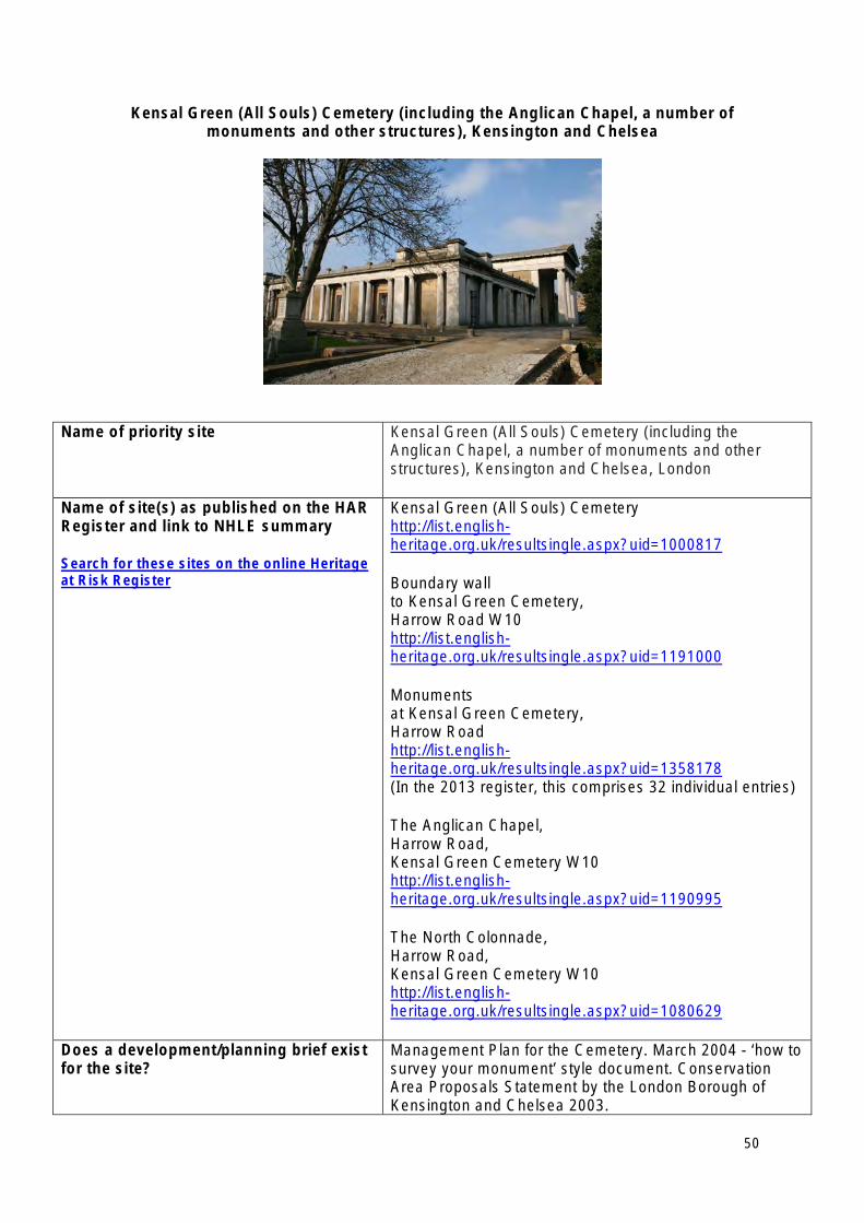
Kensal Green (All Souls) Cemetery (including the Anglican Chapel, a number of monuments and other structures), Kensington and Chelsea
Name of priority site Kensal Green (All Souls) Cemetery (including the Anglican Chapel, a number of monuments and other structures), Kensington and Chelsea, London
Name of site(s) as published on the HAR Register and link to NHLE summary
Search for these sites on the online Heritage at Risk Register
Kensal Green (All Souls) Cemetery http://list.englishheritage.org.uk/resultsingle.aspx?uid=1000817
Boundary wall to Kensal Green Cemetery, Harrow Road W10 http://list.englishheritage.org.uk/resultsingle.aspx?uid=1191000
Monuments at Kensal Green Cemetery, Harrow Road http://list.englishheritage.org.uk/resultsingle.aspx?uid=1358178 (In the 2013 register, this comprises 32 individual entries)
The Anglican Chapel, Harrow Road, Kensal Green Cemetery W10 http://list.englishheritage.org.uk/resultsingle.aspx?uid=1190995
The North Colonnade, Harrow Road, Kensal Green Cemetery W10 http://list.englishheritage.org.uk/resultsingle.aspx?uid=1080629
Does a development/planning brief exist Management Plan for the Cemetery. March 2004 - ‘how to for the site? survey your monument’ style document. Conservation
Area Proposals Statement by the London Borough of Kensington and Chelsea 2003.
50
Is the site eligible to receive EH grant aid?
If yes, for what type of work/project?
Yes • Repair works/conservation of listed tombs and
monuments. • Repair works/conservation of listed buildings and
structures. • Conservation Management Plan for the cemetery
– to look at repairs and maintenance of tombs and management of the grade I Registered Park and Garden
• Options appraisal for future use of Anglican Chapel
Original use Cemetery
Last known use Still operating as a cemetery
Potential future uses • Will continue as a working cemetery, although could look to promote greater public use by promotion of wildlife and educational use.
• Scope for the Anglican Chapel to be used for education, functions etc. if repaired. Currently discussing the possibility of an options appraisal to look at future uses for the chapel, possibly leading to grant applications to the HLF and/or other grant giving bodies.
Which areas of the site are known to be of concern?
• Grade II listed boundary wall to Harrow Road partially collapsed and partially dismantled where at risk of further collapse. In need of substantial rebuilding. Works underway with the benefit of EH grant funding.
• Grade I listed Anglican Chapel, not currently used – in need of repair. Major issues with water ingress to colonnade and catacombs.
• Grade II listed Northern Colonnade interior in poor condition. One bay currently under repair, with the benefit of EH grant funding.
• The 32 listed monuments now included in the Heritage at Risk Register. There are also many unlisted monuments that are in a poor state of repair.
• Management of the grade I Registered Park and Garden – particularly in respect to the design and location of new memorials and burials, management of waste materials, maintenance of key routes through the site
Is the site for sale? No Lead contact at the local planning authority
Name: Mark Butler Number: 0207 361 3000 Email address: [email protected] Local Authority: Royal Borough of Kensington & Chelsea.
51
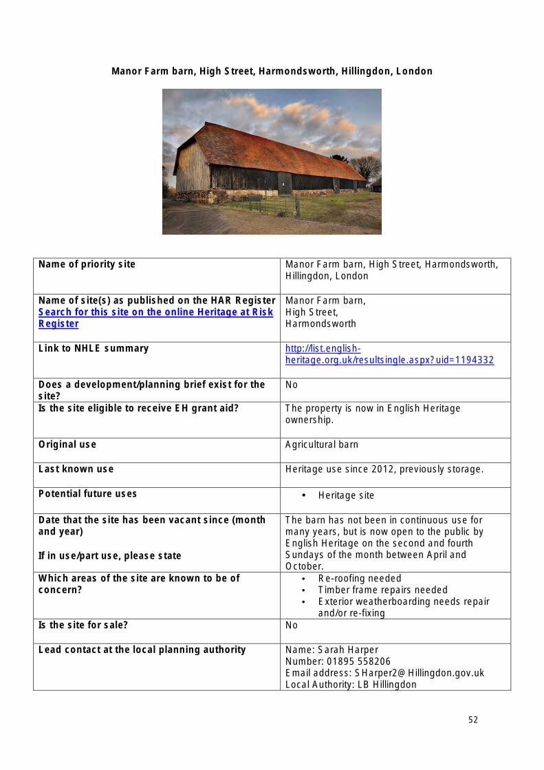
Manor Farm barn, High Street, Harmondsworth, Hillingdon, London
Name of priority site Manor Farm barn, High Street, Harmondsworth, Hillingdon, London
Name of site(s) as published on the HAR Register Search for this site on the online Heritage at Risk Register
Manor Farm barn, High Street, Harmondsworth
Link to NHLE summary http://list.englishheritage.org.uk/resultsingle.aspx?uid=1194332
Does a development/planning brief exist for the site?
No
Is the site eligible to receive EH grant aid? The property is now in English Heritage ownership.
Original use Agricultural barn
Last known use Heritage use since 2012, previously storage.
Potential future uses • Heritage site
Date that the site has been vacant since (month and year)
If in use/part use, please state
The barn has not been in continuous use for many years, but is now open to the public by English Heritage on the second and fourth Sundays of the month between April and October.
Which areas of the site are known to be of concern?
• Re-roofing needed • Timber frame repairs needed • Exterior weatherboarding needs repair
and/or re-fixing Is the site for sale? No
Lead contact at the local planning authority Name: Sarah Harper Number: 01895 558206 Email address: [email protected] Local Authority: LB Hillingdon
52
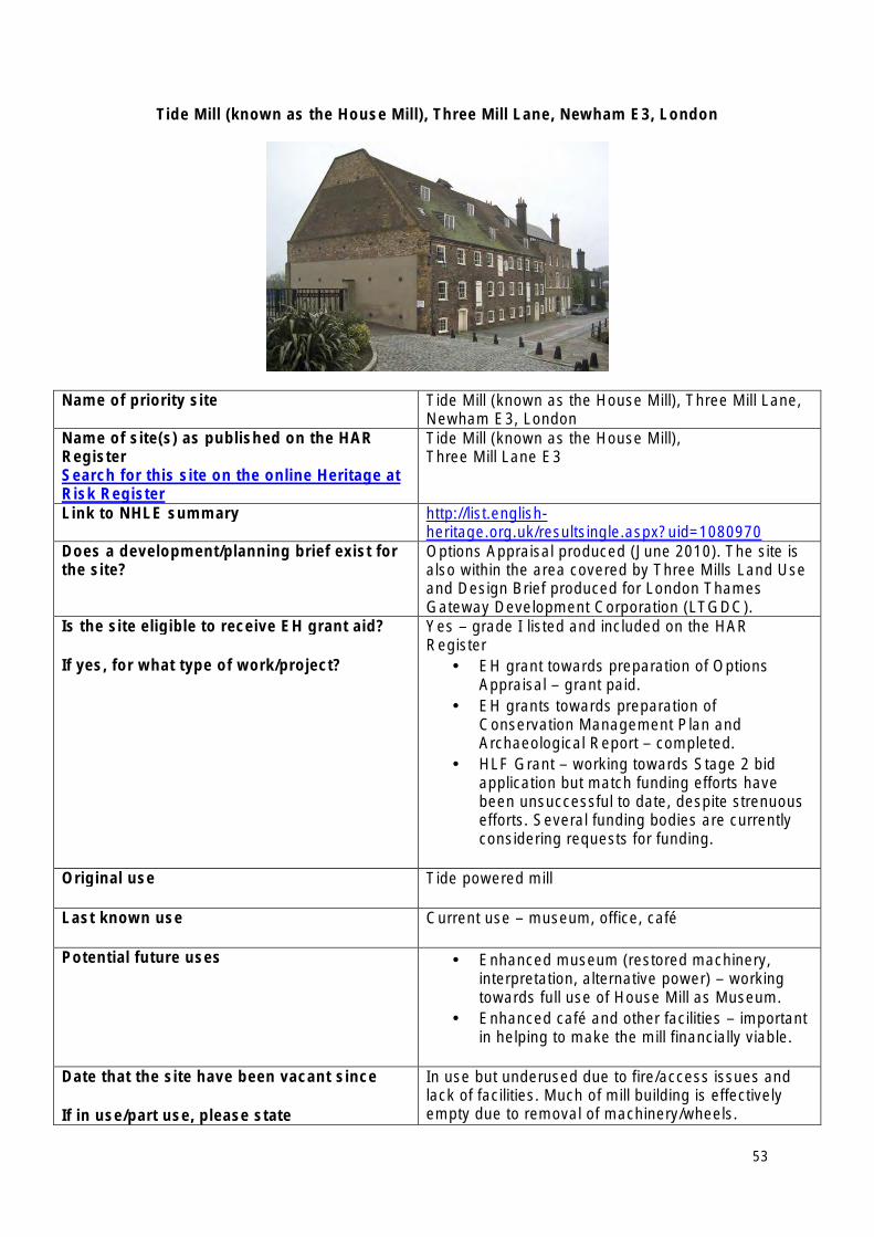
Tide Mill (known as the House Mill), Three Mill Lane, Newham E3, London
Name of priority site Tide Mill (known as the House Mill), Three Mill Lane, Newham E3, London
Name of site(s) as published on the HAR Register Search for this site on the online Heritage at Risk Register
Tide Mill (known as the House Mill), Three Mill Lane E3
Link to NHLE summary http://list.englishheritage.org.uk/resultsingle.aspx?uid=1080970
Does a development/planning brief exist for the site?
Options Appraisal produced (June 2010). The site is also within the area covered by Three Mills Land Use and Design Brief produced for London Thames Gateway Development Corporation (LTGDC).
Is the site eligible to receive EH grant aid?
If yes, for what type of work/project?
Yes – grade I listed and included on the HAR Register
• EH grant towards preparation of Options Appraisal – grant paid.
• EH grants towards preparation of Conservation Management Plan and Archaeological Report – completed.
• HLF Grant – working towards Stage 2 bid application but match funding efforts have been unsuccessful to date, despite strenuous efforts. Several funding bodies are currently considering requests for funding.
Original use Tide powered mill
Last known use Current use – museum, office, café
Potential future uses • Enhanced museum (restored machinery, interpretation, alternative power) – working towards full use of House Mill as Museum.
• Enhanced café and other facilities – important in helping to make the mill financially viable.
Date that the site have been vacant since
If in use/part use, please state
In use but underused due to fire/access issues and lack of facilities. Much of mill building is effectively empty due to removal of machinery/wheels.
53
Which areas of the site are known to be of concern?
• Mill wheels – in pieces • Interior of House Mill. Underused, primarily
due to access/fire rating issues etc.
Is the site for sale? No
Lead contact at the local planning authority Name: Ben Hull (Conservation Officer) Number: 020 3373 9574 Email address:[email protected] Local Authority: London Borough of Newham
54
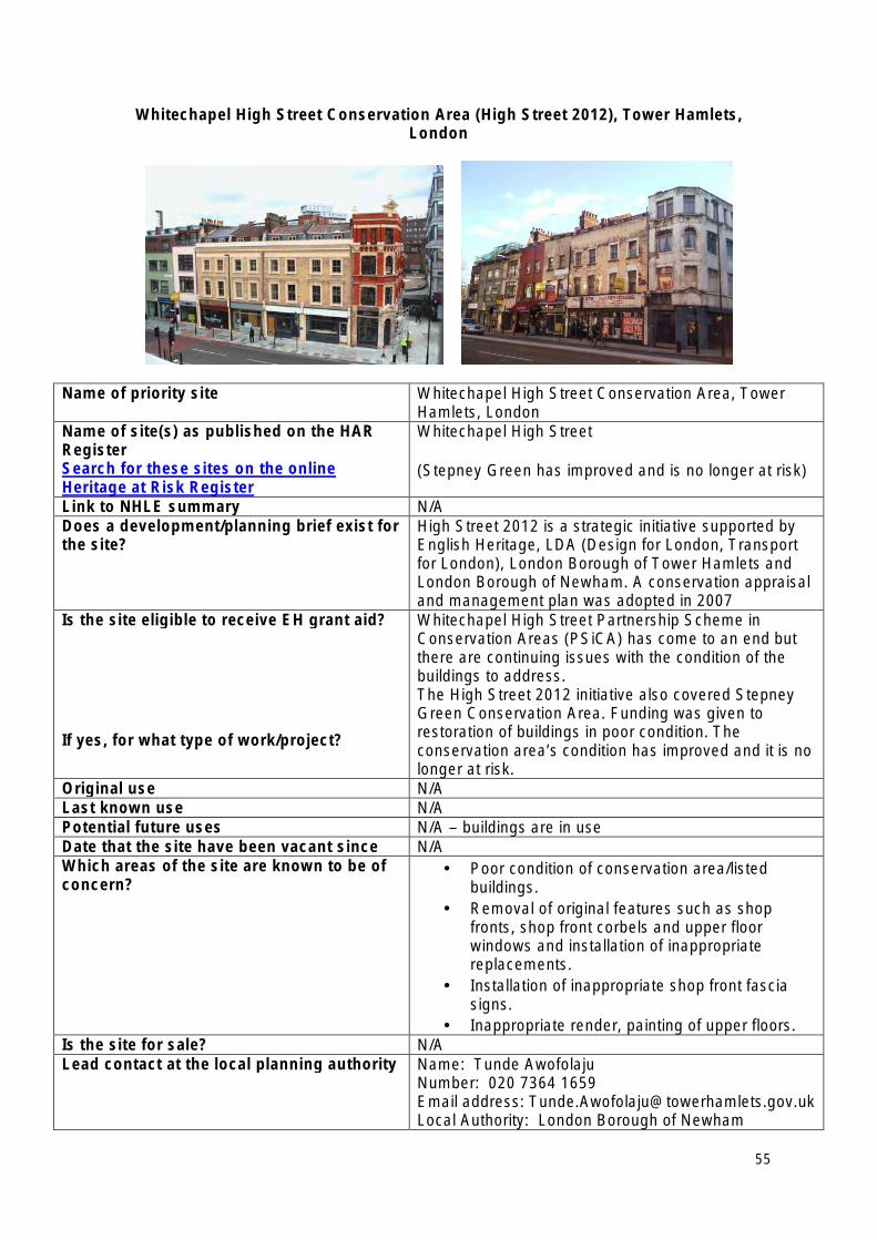
Whitechapel High Street Conservation Area (High Street 2012), Tower Hamlets, London
Name of priority site Whitechapel High Street Conservation Area, Tower Hamlets, London
Name of site(s) as published on the HAR Register Search for these sites on the online Heritage at Risk Register
Whitechapel High Street
(Stepney Green has improved and is no longer at risk)
Link to NHLE summary N/A Does a development/planning brief exist for the site?
High Street 2012 is a strategic initiative supported by English Heritage, LDA (Design for London, Transport for London), London Borough of Tower Hamlets and London Borough of Newham. A conservation appraisal and management plan was adopted in 2007
Is the site eligible to receive EH grant aid?
If yes, for what type of work/project?
Whitechapel High Street Partnership Scheme in Conservation Areas (PSiCA) has come to an end but there are continuing issues with the condition of the buildings to address. The High Street 2012 initiative also covered Stepney Green Conservation Area. Funding was given to restoration of buildings in poor condition. The conservation area’s condition has improved and it is no longer at risk.
Original use N/A Last known use N/A Potential future uses N/A – buildings are in use Date that the site have been vacant since N/A Which areas of the site are known to be of concern?
• Poor condition of conservation area/listed buildings.
• Removal of original features such as shop fronts, shop front corbels and upper floor windows and installation of inappropriate replacements.
• Installation of inappropriate shop front fascia signs.
• Inappropriate render, painting of upper floors. Is the site for sale? N/A Lead contact at the local planning authority Name: Tunde Awofolaju
Number: 020 7364 1659 Email address: [email protected] Local Authority: London Borough of Newham
55
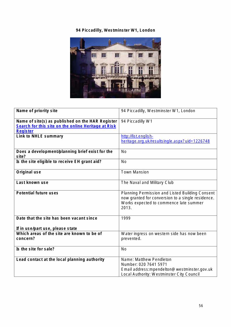
94 Piccadilly, Westminster W1, London
Name of priority site 94 Piccadilly, Westminster W1, London
Name of site(s) as published on the HAR Register Search for this site on the online Heritage at Risk Register
94 Piccadilly W1
Link to NHLE summary http://list.englishheritage.org.uk/resultsingle.aspx?uid=1226748
Does a development/planning brief exist for the site?
No
Is the site eligible to receive EH grant aid? No
Original use Town Mansion
Last known use The Naval and Military Club
Potential future uses Planning Permission and Listed Building Consent now granted for conversion to a single residence. Works expected to commence late summer 2013.
Date that the site has been vacant since
If in use/part use, please state
1999
Which areas of the site are known to be of concern?
Water ingress on western side has now been prevented.
Is the site for sale? No
Lead contact at the local planning authority Name: Matthew Pendleton Number: 020 7641 5971 Email address:[email protected] Local Authority: Westminster City Council
56
North East Heritage at Risk Priority Sites 2013
• Bowes Railway Incline, Birtley, Gateshead
• Greenhouse east of Felton Park with potting shed, Felton Park, Felton, Northumberland
• Harperley Working Camp, WWII POW Camp at Craigside, Wolsingham, County Durham
• Kirkleatham Hall Stables and Landscape (Kirkleatham Hall Stables, Bastion and ha-ha wall north of Kirkleatham Hall Stables, Bastion north west of Kirkleatham Hall Stables), Redcar, Tees Valley
• Monastic cell and medieval tower, Coquet Island, Hauxley, Northumberland
• Prebends’ Bridge, Durham and Framwellgate, Durham, County Durham
• Ravensworth Castle, Lamesley (Ravensworth Castle and Nash House), Gateshead
• Sockburn Hall and Church (Sockburn Hall, and the Church of All Saints) Sockburn Lane, Sockburn, Darlington
• Small multivallate hillfort and tower mill on Shackleton Beacon Hill, Heighington, Darlington
• Ushaw College, Esh (Chapel of St Michael at College of St Cuthbert, Former Junior Seminary Chapel of St. Aloysius and Bounds Wall), County Durham
57
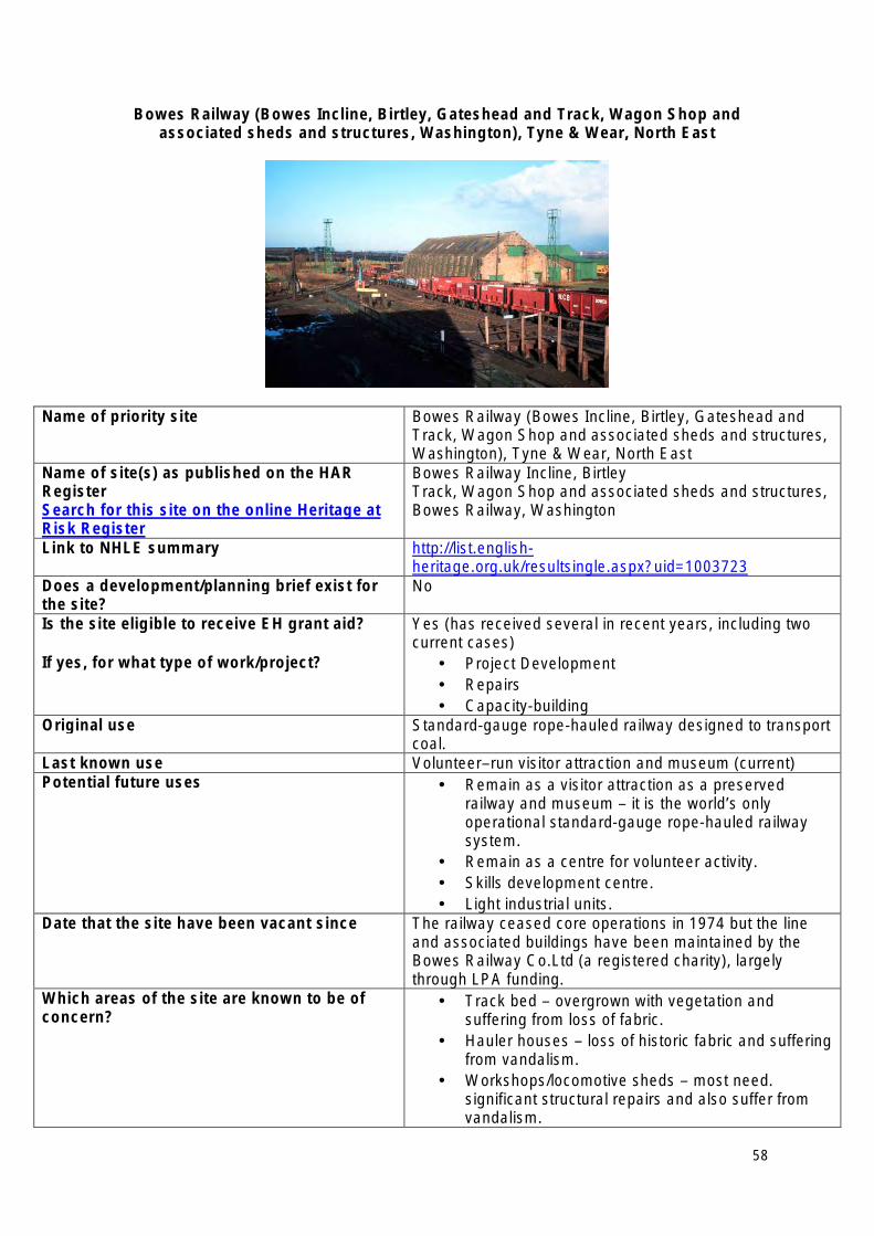
Bowes Railway (Bowes Incline, Birtley, Gateshead and Track, Wagon Shop and associated sheds and structures, Washington), Tyne & Wear, North East
Name of priority site Bowes Railway (Bowes Incline, Birtley, Gateshead and Track, Wagon Shop and associated sheds and structures, Washington), Tyne & Wear, North East
Name of site(s) as published on the HAR Bowes Railway Incline, Birtley Register Track, Wagon Shop and associated sheds and structures, Search for this site on the online Heritage at Bowes Railway, Washington Risk Register Link to NHLE summary http://list.english
heritage.org.uk/resultsingle.aspx?uid=1003723 Does a development/planning brief exist for the site?
No
Is the site eligible to receive EH grant aid? Yes (has received several in recent years, including two current cases)
If yes, for what type of work/project? • Project Development • Repairs • Capacity-building
Original use Standard-gauge rope-hauled railway designed to transport coal.
Last known use Volunteer–run visitor attraction and museum (current) Potential future uses • Remain as a visitor attraction as a preserved
railway and museum – it is the world’s only operational standard-gauge rope-hauled railway system.
• Remain as a centre for volunteer activity. • Skills development centre. • Light industrial units.
Date that the site have been vacant since The railway ceased core operations in 1974 but the line and associated buildings have been maintained by the Bowes Railway Co.Ltd (a registered charity), largely through LPA funding.
Which areas of the site are known to be of concern?
• Track bed – overgrown with vegetation and suffering from loss of fabric.
• Hauler houses – loss of historic fabric and suffering from vandalism.
• Workshops/locomotive sheds – most need. significant structural repairs and also suffer from vandalism.
58
• Capacity of the Bowes Railway Board to deliver long-term management of the site.
Is the site for sale? No Lead contact at the local planning authority Name: Mark Taylor
Number: 0191 5611515 Email address: [email protected] Local Authority: Sunderland City Council (although the railway also covers Gateshead Metropolitan BC)
59
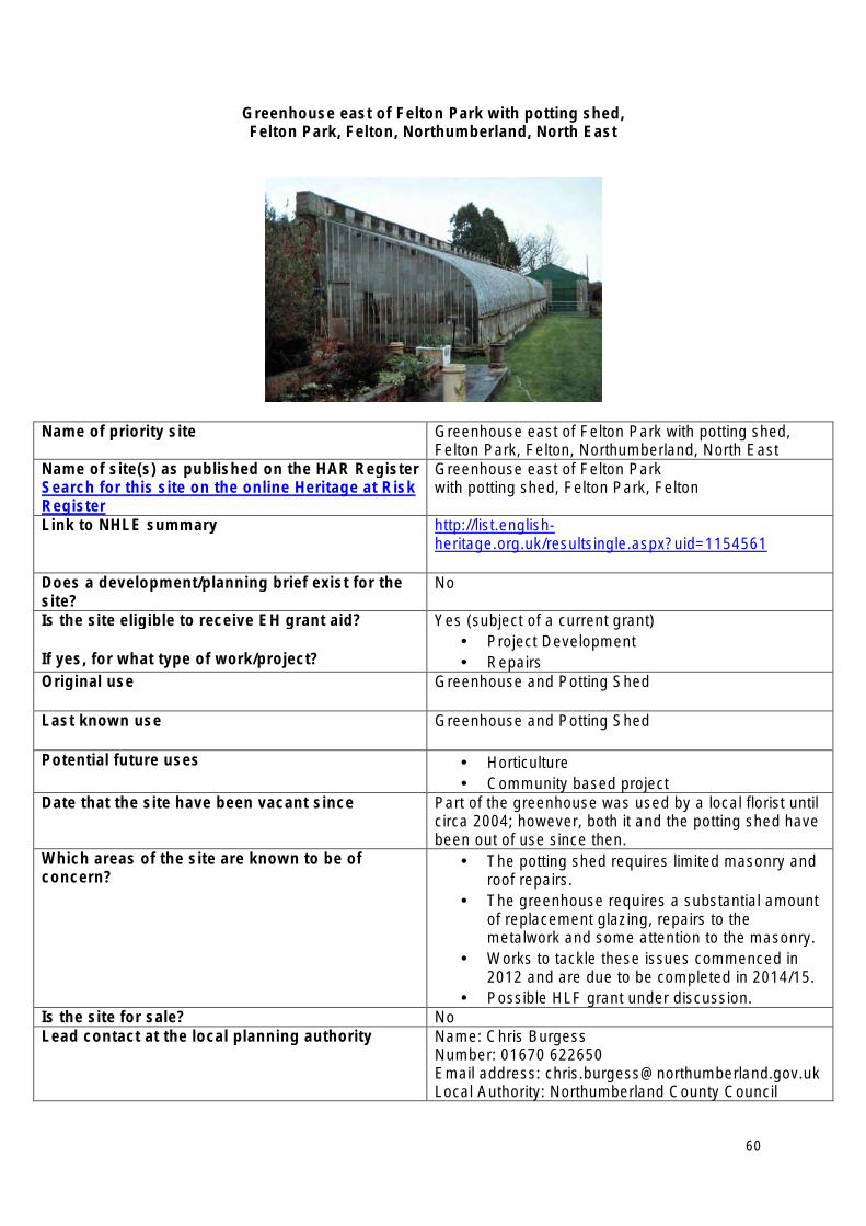
Greenhouse east of Felton Park with potting shed, Felton Park, Felton, Northumberland, North East
Name of priority site Greenhouse east of Felton Park with potting shed, Felton Park, Felton, Northumberland, North East
Name of site(s) as published on the HAR Register Search for this site on the online Heritage at Risk Register
Greenhouse east of Felton Park with potting shed, Felton Park, Felton
Link to NHLE summary http://list.englishheritage.org.uk/resultsingle.aspx?uid=1154561
Does a development/planning brief exist for the site?
No
Is the site eligible to receive EH grant aid?
If yes, for what type of work/project?
Yes (subject of a current grant) • Project Development • Repairs
Original use Greenhouse and Potting Shed
Last known use Greenhouse and Potting Shed
Potential future uses • Horticulture • Community based project
Date that the site have been vacant since Part of the greenhouse was used by a local florist until circa 2004; however, both it and the potting shed have been out of use since then.
Which areas of the site are known to be of concern?
• The potting shed requires limited masonry and roof repairs.
• The greenhouse requires a substantial amount of replacement glazing, repairs to the metalwork and some attention to the masonry.
• Works to tackle these issues commenced in 2012 and are due to be completed in 2014/15.
• Possible HLF grant under discussion. Is the site for sale? No Lead contact at the local planning authority Name: Chris Burgess
Number: 01670 622650 Email address: [email protected] Local Authority: Northumberland County Council
60
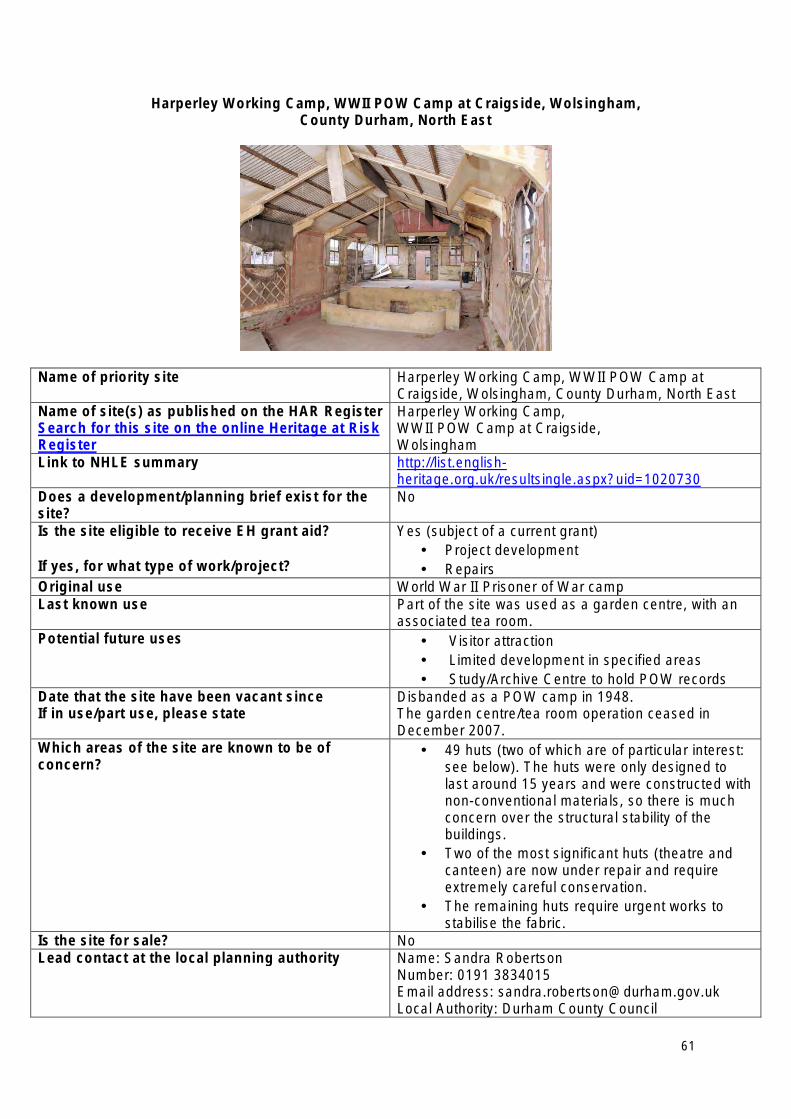
Harperley Working Camp, WWII POW Camp at Craigside, Wolsingham, County Durham, North East
Name of priority site Harperley Working Camp, WWII POW Camp at Craigside, Wolsingham, County Durham, North East
Name of site(s) as published on the HAR Register Search for this site on the online Heritage at Risk Register
Harperley Working Camp, WWII POW Camp at Craigside, Wolsingham
Link to NHLE summary http://list.englishheritage.org.uk/resultsingle.aspx?uid=1020730
Does a development/planning brief exist for the site?
No
Is the site eligible to receive EH grant aid?
If yes, for what type of work/project?
Yes (subject of a current grant) • Project development • Repairs
Original use World War II Prisoner of War camp Last known use Part of the site was used as a garden centre, with an
associated tea room. Potential future uses • Visitor attraction
• Limited development in specified areas • Study/Archive Centre to hold POW records
Date that the site have been vacant since If in use/part use, please state
Disbanded as a POW camp in 1948. The garden centre/tea room operation ceased in December 2007.
Which areas of the site are known to be of concern?
• 49 huts (two of which are of particular interest: see below). The huts were only designed to last around 15 years and were constructed with non-conventional materials, so there is much concern over the structural stability of the buildings.
• Two of the most significant huts (theatre and canteen) are now under repair and require extremely careful conservation.
• The remaining huts require urgent works to stabilise the fabric.
Is the site for sale? No Lead contact at the local planning authority Name: Sandra Robertson
Number: 0191 3834015 Email address: [email protected] Local Authority: Durham County Council
61
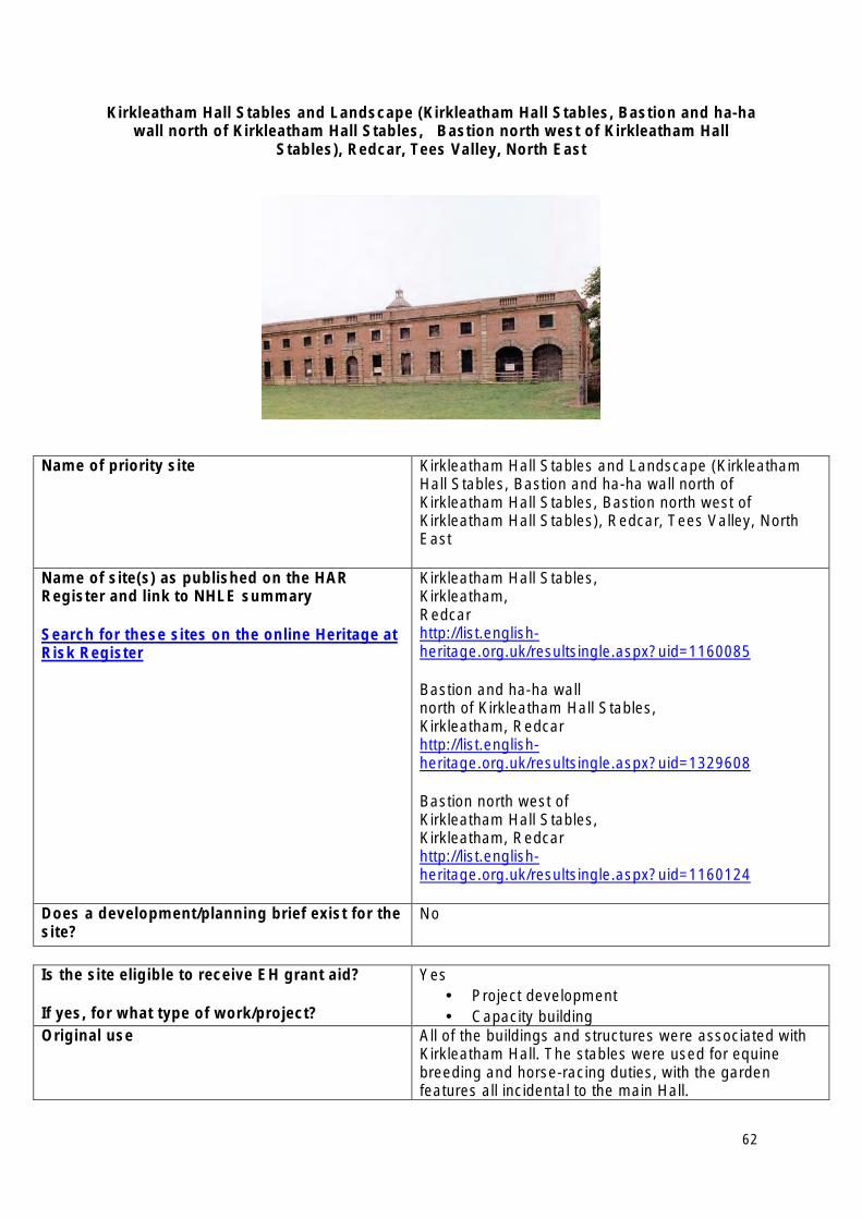
Kirkleatham Hall Stables and Landscape (Kirkleatham Hall Stables, Bastion and ha-ha wall north of Kirkleatham Hall Stables, Bastion north west of Kirkleatham Hall
Stables), Redcar, Tees Valley, North East
Name of priority site Kirkleatham Hall Stables and Landscape (Kirkleatham Hall Stables, Bastion and ha-ha wall north of Kirkleatham Hall Stables, Bastion north west of Kirkleatham Hall Stables), Redcar, Tees Valley, North East
Name of site(s) as published on the HAR Register and link to NHLE summary
Search for these sites on the online Heritage at Risk Register
Kirkleatham Hall Stables, Kirkleatham, Redcar http://list.englishheritage.org.uk/resultsingle.aspx?uid=1160085
Bastion and ha-ha wall north of Kirkleatham Hall Stables, Kirkleatham, Redcar http://list.englishheritage.org.uk/resultsingle.aspx?uid=1329608
Bastion north west of Kirkleatham Hall Stables, Kirkleatham, Redcar http://list.englishheritage.org.uk/resultsingle.aspx?uid=1160124
Does a development/planning brief exist for the site?
No
Is the site eligible to receive EH grant aid?
If yes, for what type of work/project?
Yes • Project development • Capacity building
Original use All of the buildings and structures were associated with Kirkleatham Hall. The stables were used for equine breeding and horse-racing duties, with the garden features all incidental to the main Hall.
62
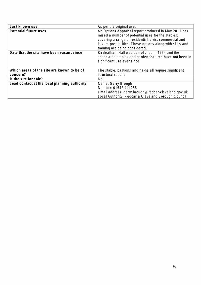
Last known use As per the original use. Potential future uses An Options Appraisal report produced in May 2011 has
raised a number of potential uses for the stables; covering a range of residential, civic, commercial and leisure possibilities. These options along with skills and training are being considered.
Date that the site have been vacant since Kirkleatham Hall was demolished in 1954 and the associated stables and garden features have not been in significant use ever since.
Which areas of the site are known to be of concern?
The stable, bastions and ha-ha all require significant structural repairs.
Is the site for sale? No Lead contact at the local planning authority Name: Gerry Brough
Number: 01642 444258 Email address: [email protected] Local Authority: Redcar & Cleveland Borough Council
63
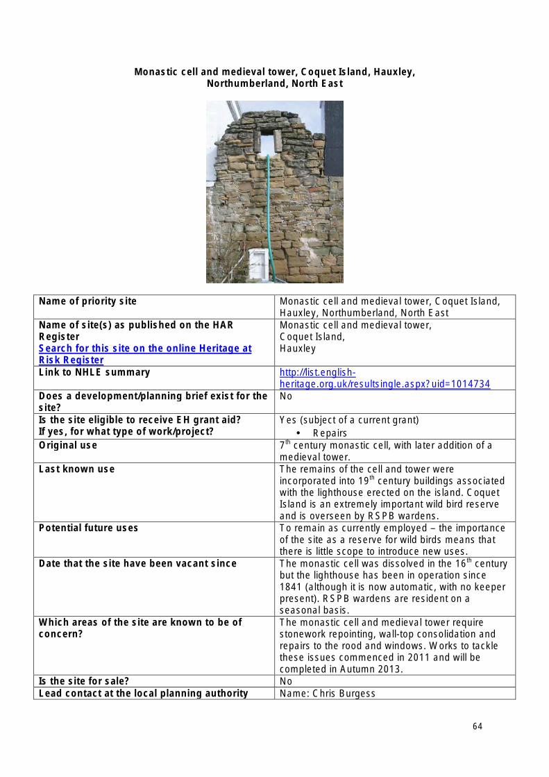
Monastic cell and medieval tower, Coquet Island, Hauxley, Northumberland, North East
Name of priority site Monastic cell and medieval tower, Coquet Island, Hauxley, Northumberland, North East
Name of site(s) as published on the HAR Register Search for this site on the online Heritage at Risk Register
Monastic cell and medieval tower, Coquet Island, Hauxley
Link to NHLE summary http://list.englishheritage.org.uk/resultsingle.aspx?uid=1014734
Does a development/planning brief exist for the site?
No
Is the site eligible to receive EH grant aid? If yes, for what type of work/project?
Yes (subject of a current grant) • Repairs
Original use 7th century monastic cell, with later addition of a medieval tower.
Last known use The remains of the cell and tower were incorporated into 19th century buildings associated with the lighthouse erected on the island. Coquet Island is an extremely important wild bird reserve and is overseen by RSPB wardens.
Potential future uses To remain as currently employed – the importance of the site as a reserve for wild birds means that there is little scope to introduce new uses.
Date that the site have been vacant since The monastic cell was dissolved in the 16th century but the lighthouse has been in operation since 1841 (although it is now automatic, with no keeper present). RSPB wardens are resident on a seasonal basis.
Which areas of the site are known to be of concern?
The monastic cell and medieval tower require stonework repointing, wall-top consolidation and repairs to the rood and windows. Works to tackle these issues commenced in 2011 and will be completed in Autumn 2013.
Is the site for sale? No Lead contact at the local planning authority Name: Chris Burgess
64

Number: 01670 622650 Email address: [email protected] Local Authority: Northumberland County Council
65
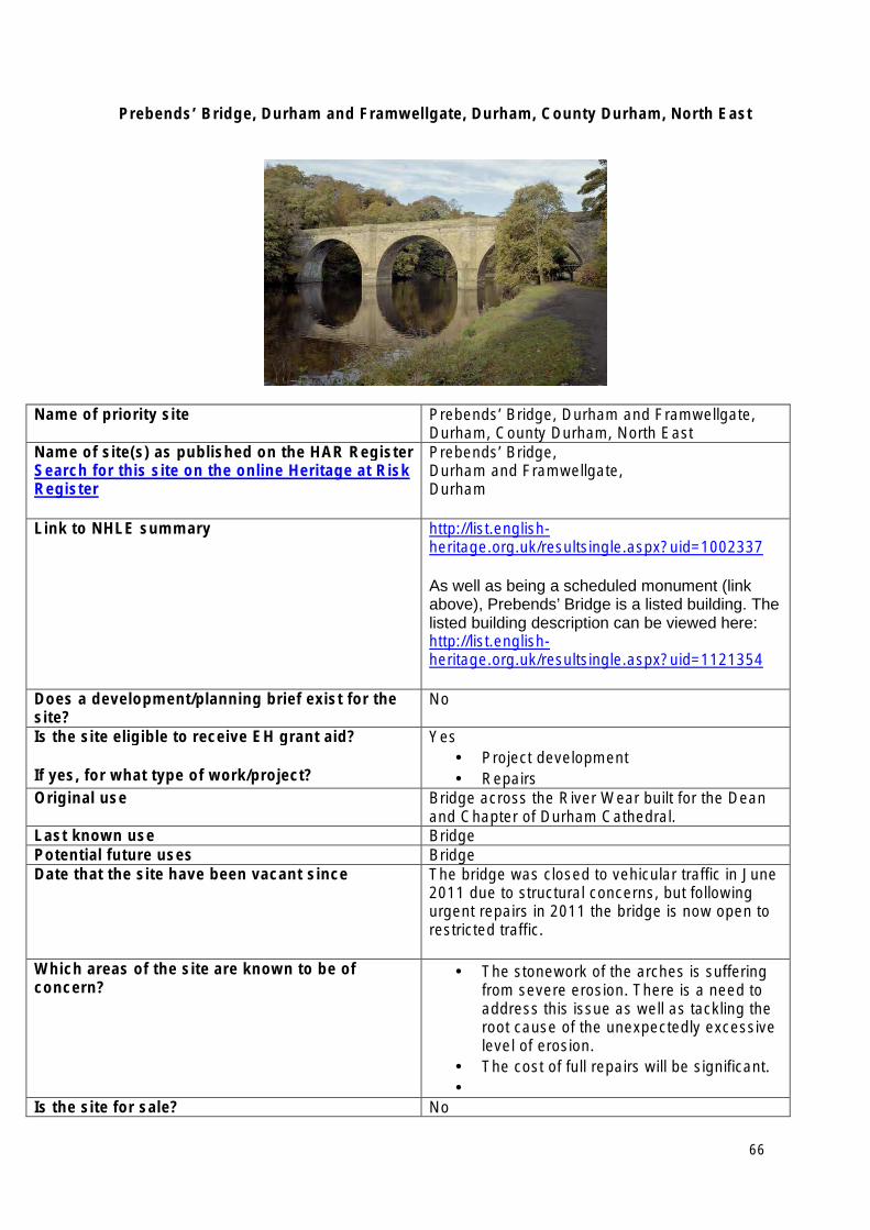
Prebends’ Bridge, Durham and Framwellgate, Durham, County Durham, North East
Name of priority site Prebends’ Bridge, Durham and Framwellgate, Durham, County Durham, North East
Name of site(s) as published on the HAR Register Search for this site on the online Heritage at Risk Register
Prebends’ Bridge, Durham and Framwellgate, Durham
Link to NHLE summary http://list.englishheritage.org.uk/resultsingle.aspx?uid=1002337
As well as being a scheduled monument (link above), Prebends’ Bridge is a listed building. The listed building description can be viewed here: http://list.englishheritage.org.uk/resultsingle.aspx?uid=1121354
Does a development/planning brief exist for the site?
No
Is the site eligible to receive EH grant aid?
If yes, for what type of work/project?
Yes • Project development • Repairs
Original use Bridge across the River Wear built for the Dean and Chapter of Durham Cathedral.
Last known use Bridge Potential future uses Bridge Date that the site have been vacant since The bridge was closed to vehicular traffic in June
2011 due to structural concerns, but following urgent repairs in 2011 the bridge is now open to restricted traffic.
Which areas of the site are known to be of concern?
• The stonework of the arches is suffering from severe erosion. There is a need to address this issue as well as tackling the root cause of the unexpectedly excessive level of erosion.
• The cost of full repairs will be significant. •
Is the site for sale? No
66

Lead contact at the local planning authority Name: Sandra Robertson Number: 0191 3834015 Email address: [email protected] Local Authority: Durham County Council
67
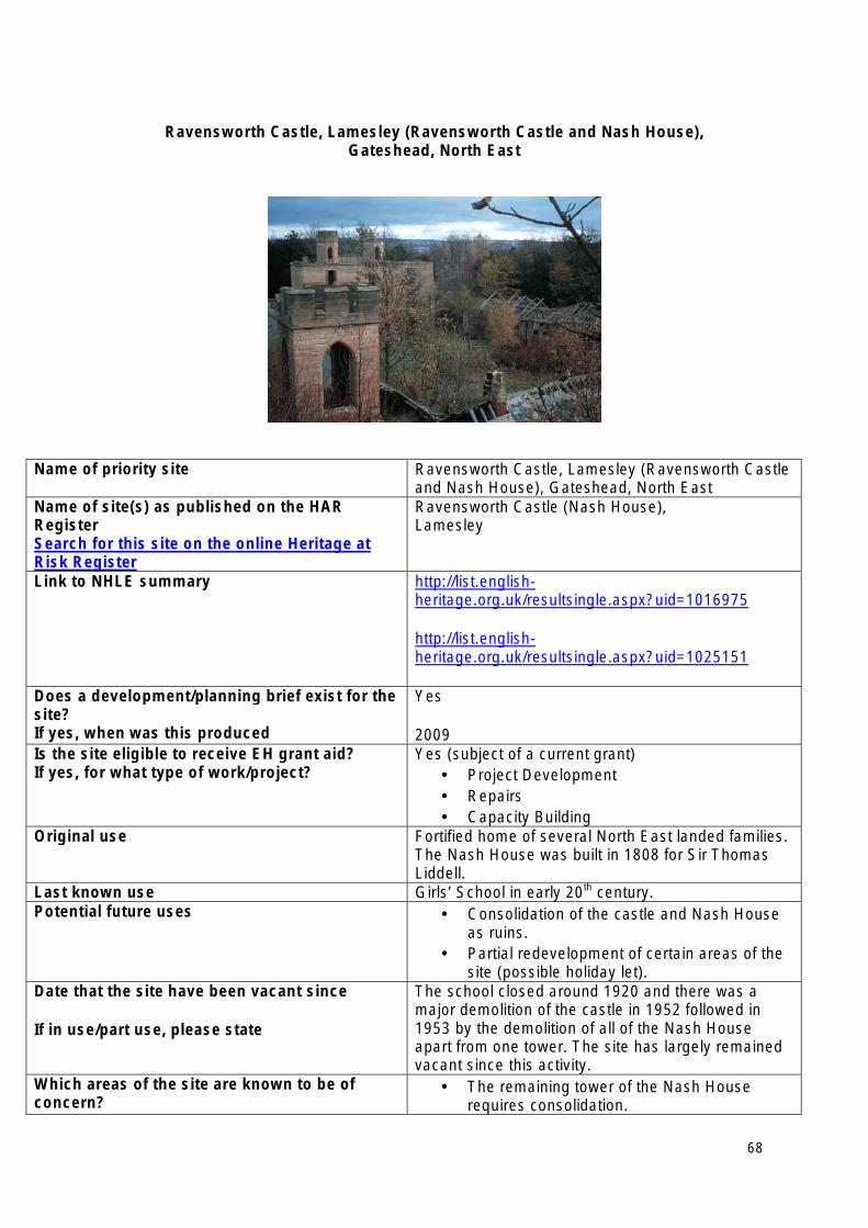
Ravensworth Castle, Lamesley (Ravensworth Castle and Nash House), Gateshead, North East
Name of priority site Ravensworth Castle, Lamesley (Ravensworth Castle and Nash House), Gateshead, North East
Name of site(s) as published on the HAR Register Search for this site on the online Heritage at Risk Register
Ravensworth Castle (Nash House), Lamesley
Link to NHLE summary http://list.englishheritage.org.uk/resultsingle.aspx?uid=1016975
http://list.englishheritage.org.uk/resultsingle.aspx?uid=1025151
Does a development/planning brief exist for the site? If yes, when was this produced
Yes
2009 Is the site eligible to receive EH grant aid? If yes, for what type of work/project?
Yes (subject of a current grant) • Project Development • Repairs • Capacity Building
Original use Fortified home of several North East landed families. The Nash House was built in 1808 for Sir Thomas Liddell.
Last known use Girls’ School in early 20th century. Potential future uses • Consolidation of the castle and Nash House
as ruins. • Partial redevelopment of certain areas of the
site (possible holiday let). Date that the site have been vacant since
If in use/part use, please state
The school closed around 1920 and there was a major demolition of the castle in 1952 followed in 1953 by the demolition of all of the Nash House apart from one tower. The site has largely remained vacant since this activity.
Which areas of the site are known to be of concern?
• The remaining tower of the Nash House requires consolidation.
68
• Consolidation is also required to the medieval castle towers, walls and ice house.
Is the site for sale? No Lead contact at the local planning authority Name: Clare Lacy
Number: 0191 4333510 Email address: [email protected] Local Authority: Gateshead Metropolitan Borough Council
69
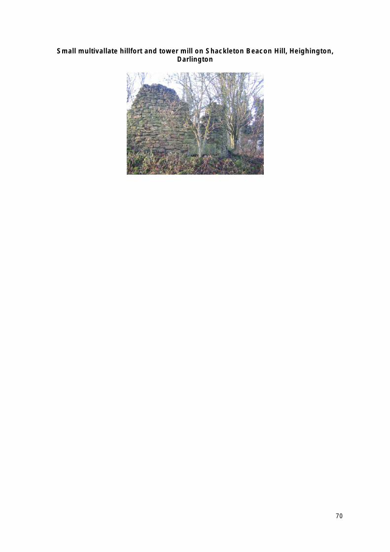
Small multivallate hillfort and tower mill on Shackleton Beacon Hill, Heighington, Darlington
70
Name of priority site (as it should appear on the priority list, plus region/locality)
Small multivallate hillfort and tower mill on Shackleton Beacon Hill, Heighington, Darlington, North East
Name of site(s) as published on the HAR Register Search for this site on the online Heritage at Risk Register
The site at Shackleton Beacon Hill is merely the primary site amongst a group of scheduled earthworks that will be batched and tackled as part of an overall project during 2012/14. Other sites include (with Monument Numbers):
Round barrow on Upsall Moor (also known as Mount Pleasant), Redcar & Cleveland 31997 1018658
Remains of the Stockton and Darlington Railway, Co Durham DU108/d 1002315
Remains of Roman aqueduct DU59/a 1005582
The Castles (camp), Co Durham DU13 1002357
Motte and bailey castle 400m south east of Bishopton, Darlington 20970 1008668
Link to NHLE summary http://list.englishheritage.org.uk/resultsingle.aspx?uid=1016867
Does a development/planning brief exist for the site?
If yes, when was this produced (please provide month and year)?
No
Is the site eligible to receive EH grant aid?
If yes, for what type of work/project?
Yes • Scrub clearance • Removal of saplings
Original use (if known, if not known, please state first known use)
Defence
Last known use Agricultural Potential future uses Return to agriculture Date that the site has been vacant since (month and year). If in use/part use, please state
N/A
Which areas of the site are known to be of concern? The site at Shackleton Beacon Hill is at increasing risk from unchecked tree and scrub growth and is at “high risk”. The other sites listed above are not all at “high risk” but are declining in condition and need remedial action to prevent further deterioration.
Is the site for sale? No Lead contact at the local planning authority Name Timothy Crawshaw
Number: 01325 388048 Emailaddress:[email protected] Local Authority: Darlington Borough Council
71
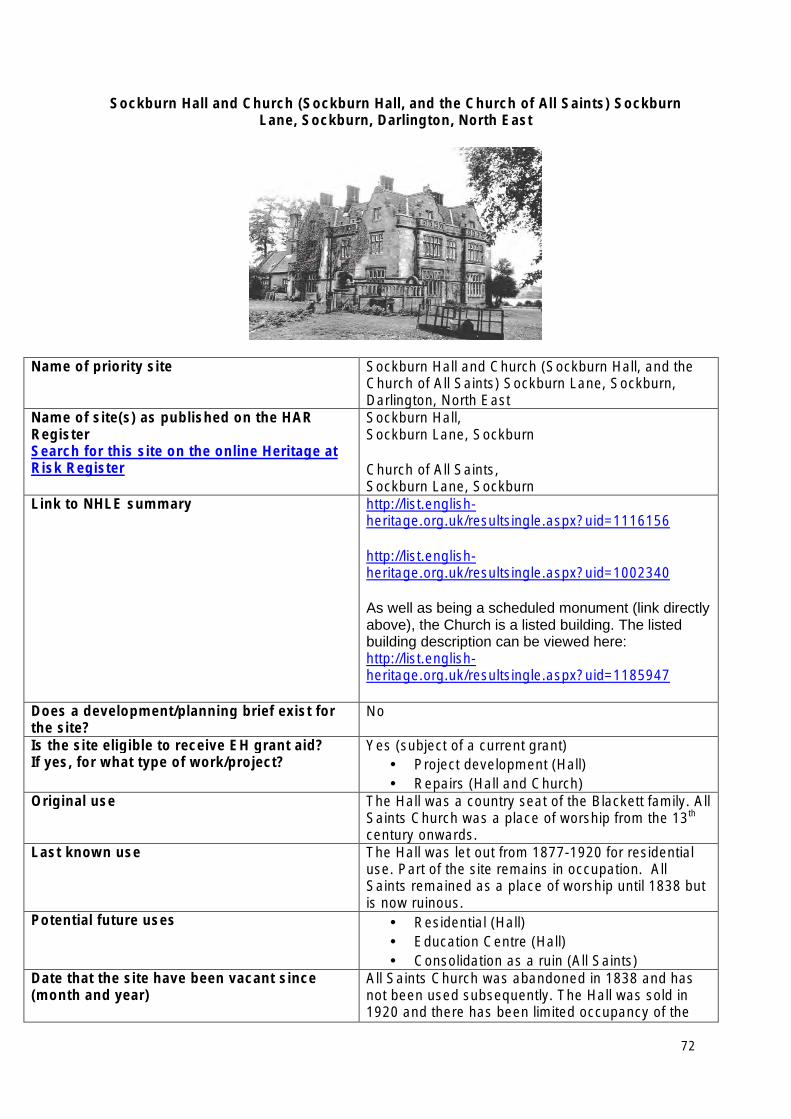
Sockburn Hall and Church (Sockburn Hall, and the Church of All Saints) Sockburn Lane, Sockburn, Darlington, North East
Name of priority site Sockburn Hall and Church (Sockburn Hall, and the Church of All Saints) Sockburn Lane, Sockburn, Darlington, North East
Name of site(s) as published on the HAR Register Search for this site on the online Heritage at Risk Register
Sockburn Hall, Sockburn Lane, Sockburn
Church of All Saints, Sockburn Lane, Sockburn
Link to NHLE summary http://list.englishheritage.org.uk/resultsingle.aspx?uid=1116156
http://list.englishheritage.org.uk/resultsingle.aspx?uid=1002340
As well as being a scheduled monument (link directly above), the Church is a listed building. The listed building description can be viewed here: http://list.englishheritage.org.uk/resultsingle.aspx?uid=1185947
Does a development/planning brief exist for the site?
No
Is the site eligible to receive EH grant aid? If yes, for what type of work/project?
Yes (subject of a current grant) • Project development (Hall) • Repairs (Hall and Church)
Original use The Hall was a country seat of the Blackett family. All Saints Church was a place of worship from the 13th
century onwards. Last known use The Hall was let out from 1877-1920 for residential
use. Part of the site remains in occupation. All Saints remained as a place of worship until 1838 but is now ruinous.
Potential future uses • Residential (Hall) • Education Centre (Hall) • Consolidation as a ruin (All Saints)
Date that the site have been vacant since (month and year)
All Saints Church was abandoned in 1838 and has not been used subsequently. The Hall was sold in 1920 and there has been limited occupancy of the
72

If in use/part use, please state site since then. Which areas of the site are known to be of concern?
• The Hall has rotten floor and roof members, along with general structural issues including further urgent repairs.
• Although there have been recent phases of urgent repairs, further consolidation of All Saints Church is required.
Is the site for sale? No Lead contact at the local planning authority Name: Heather Nelson
Number: 01325 388604 Email address:[email protected] Local Authority: Darlington Borough Council
73
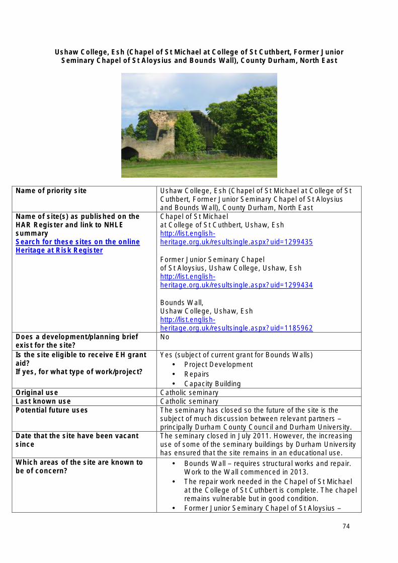
Ushaw College, Esh (Chapel of St Michael at College of St Cuthbert, Former Junior Seminary Chapel of St Aloysius and Bounds Wall), County Durham, North East
Name of priority site Ushaw College, Esh (Chapel of St Michael at College of St Cuthbert, Former Junior Seminary Chapel of St Aloysius and Bounds Wall), County Durham, North East
Name of site(s) as published on the HAR Register and link to NHLE summary Search for these sites on the online Heritage at Risk Register
Chapel of St Michael at College of St Cuthbert, Ushaw, Esh http://list.englishheritage.org.uk/resultsingle.aspx?uid=1299435
Former Junior Seminary Chapel of St Aloysius, Ushaw College, Ushaw, Esh http://list.englishheritage.org.uk/resultsingle.aspx?uid=1299434
Bounds Wall, Ushaw College, Ushaw, Esh http://list.englishheritage.org.uk/resultsingle.aspx?uid=1185962
Does a development/planning brief exist for the site?
No
Is the site eligible to receive EH grant Yes (subject of current grant for Bounds Walls) aid? • Project Development If yes, for what type of work/project? • Repairs
• Capacity Building Original use Catholic seminary Last known use Catholic seminary Potential future uses The seminary has closed so the future of the site is the
subject of much discussion between relevant partners – principally Durham County Council and Durham University.
Date that the site have been vacant since
The seminary closed in July 2011. However, the increasing use of some of the seminary buildings by Durham University has ensured that the site remains in an educational use.
Which areas of the site are known to be of concern?
• Bounds Wall – requires structural works and repair. Work to the Wall commenced in 2013.
• The repair work needed in the Chapel of St Michael at the College of St Cuthbert is complete. The chapel remains vulnerable but in good condition.
• Former Junior Seminary Chapel of St Aloysius –
74

repairs required to the interior and glazing • Junior House (Grade II) – requires urgent repairs
and is at serious risk of significant damage. • The long-term future use of the whole seminary site.
Is the site for sale? No Lead contact at the local planning authority
Name: Stuart Timmis Number: 0191 3871919 Email address: [email protected] Local Authority: Durham County Council
75
North West Heritage at Risk Priority Sites 2013
• Castle Hill motte and ditch system, Oldcastle, Cheshire
• Central General Service Hangar, South Road, Hooton, Ellesmere Port, Cheshire
• Church of St James, St James’s Place, Liverpool, Merseyside
• Flaybrick Memorial Gardens, Wirral, Merseyside
• Police and Fire Station, London Road, Manchester
• Ribchester Roman fort (Bremetennacum), Ribchester, Ribble Valley, Lancashire
• Scarisbrick Hall, Southport Road, Scarisbrick, Ormskrik, Lancashire
• Shieling settlement close to the mouth of Scale Beck, Loweswater, Allerdale, Cumbria
• The Winter Gardens, Adelaide Street, Blackpool
• Wycliffe Congregational Chapel, Wellington Road North, Heaton Norris, Stockport
76
Castle Hill motte and ditch system, Oldcastle, Cheshire, North West
Name of priority site Castle Hill motte and ditch system, Oldcastle, Cheshire, North West
Name of site(s) as published on the HAR Register Search for this site on the online Heritage at Risk Register
Castle Hill motte and ditch system, Oldcastle, Oldcastle
Link to NHLE summary http://list.englishheritage.org.uk/resultsingle.aspx?uid=1012124
Does a development/planning brief exist for the site?
Yes
Is the site eligible to receive EH grant aid?
If yes, for what type of work/project?
Yes
Management Agreement for tree removal and badger re-location
Original use Defensive system
Last known use Agriculture and unmanaged woodland
Potential future uses • Agricultural • Low-impact sustainable tourism
Date that the site has been vacant since
If in use/part use, please state
In agricultural use
Which areas of the site are known to be of concern?
• Motte area – tree clearance and badger re-location
• Moat area – scrub clearance
Is the site for sale? No
Lead contact at the local planning authority Name: Jill Collens Number: 01244 603204 Email address: [email protected] Local Authority: Cheshire West and Chester Council/Cheshire East
77
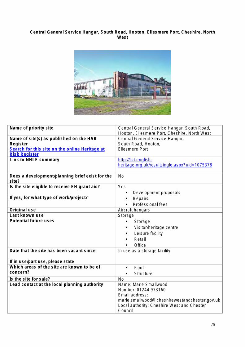
Central General Service Hangar, South Road, Hooton, Ellesmere Port, Cheshire, North West
Name of priority site Central General Service Hangar, South Road, Hooton, Ellesmere Port, Cheshire, North West
Name of site(s) as published on the HAR Register Search for this site on the online Heritage at Risk Register
Central General Service Hangar, South Road, Hooton, Ellesmere Port
Link to NHLE summary http://list.englishheritage.org.uk/resultsingle.aspx?uid=1075378
Does a development/planning brief exist for the site?
No
Is the site eligible to receive EH grant aid?
If yes, for what type of work/project?
Yes • Development proposals • Repairs • Professional fees
Original use Aircraft hangars Last known use Storage Potential future uses • Storage
• Visitor/heritage centre • Leisure facility • Retail • Office
Date that the site has been vacant since
If in use/part use, please state
In use as a storage facility
Which areas of the site are known to be of concern?
• Roof • Structure
Is the site for sale? No Lead contact at the local planning authority Name: Marie Smallwood
Number: 01244 973160 Email address: [email protected] Local authority: Cheshire West and Chester Council
78
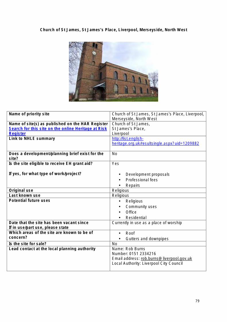
Church of St James, St James’s Place, Liverpool, Merseyside, North West
Name of priority site Church of St James, St James’s Place, Liverpool, Merseyside, North West
Name of site(s) as published on the HAR Register Search for this site on the online Heritage at Risk Register
Church of St James, St James’s Place, Liverpool
Link to NHLE summary http://list.englishheritage.org.uk/resultsingle.aspx?uid=1209882
Does a development/planning brief exist for the site?
No
Is the site eligible to receive EH grant aid?
If yes, for what type of work/project?
Yes
• Development proposals • Professional fees • Repairs
Original use Religious Last known use Religious Potential future uses • Religious
• Community uses • Office • Residential
Date that the site has been vacant since If in use/part use, please state
Currently in use as a place of worship
Which areas of the site are known to be of concern?
• Roof • Gutters and downpipes
Is the site for sale? No Lead contact at the local planning authority Name: Rob Burns
Number: 0151 2334216 Email address: [email protected] Local Authority: Liverpool City Council
79
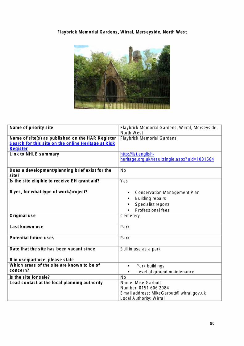
Flaybrick Memorial Gardens, Wirral, Merseyside, North West
Name of priority site Flaybrick Memorial Gardens, Wirral, Merseyside, North West
Name of site(s) as published on the HAR Register Search for this site on the online Heritage at Risk Register
Flaybrick Memorial Gardens
Link to NHLE summary http://list.englishheritage.org.uk/resultsingle.aspx?uid=1001564
Does a development/planning brief exist for the site?
No
Is the site eligible to receive EH grant aid?
If yes, for what type of work/project?
Yes
• Conservation Management Plan • Building repairs • Specialist reports • Professional fees
Original use Cemetery
Last known use Park
Potential future uses Park
Date that the site has been vacant since
If in use/part use, please state
Still in use as a park
Which areas of the site are known to be of concern?
• Park buildings • Level of ground maintenance
Is the site for sale? No Lead contact at the local planning authority Name: Mike Garbutt
Number: 0151 606 2084 Email address: [email protected] Local Authority: Wirral
80
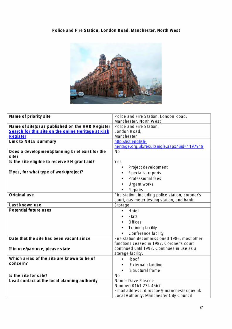
Police and Fire Station, London Road, Manchester, North West
Name of priority site Police and Fire Station, London Road, Manchester, North West
Name of site(s) as published on the HAR Register Search for this site on the online Heritage at Risk Register
Police and Fire Station, London Road, Manchester
Link to NHLE summary http://list.englishheritage.org.uk/resultsingle.aspx?uid=1197918
Does a development/planning brief exist for the site?
No
Is the site eligible to receive EH grant aid?
If yes, for what type of work/project?
Yes • Project development • Specialist reports • Professional fees • Urgent works • Repairs
Original use Fire station, including police station, coroner’s court, gas meter testing station, and bank.
Last known use Storage Potential future uses • Hotel
• Flats • Offices • Training facility • Conference facility
Date that the site has been vacant since
If in use/part use, please state
Fire station decommissioned 1986, most other functions ceased in 1987. Coroner’s court continued until 1998. Continues in use as a storage facility.
Which areas of the site are known to be of concern?
• Roof • External cladding • Structural frame
Is the site for sale? No Lead contact at the local planning authority Name: Dave Roscoe
Number: 0161 234 4567 Email address: [email protected] Local Authority: Manchester City Council
81
Ribchester Roman fort (Bremetennacum), Ribchester, Ribble Valley, Lancashire, North West
Name of priority site Ribchester Roman fort (Bremetennacum), Ribchester, Ribble Valley, Lancashire, North West
Name of site(s) as published on the HAR Register Search for this site on the online Heritage at Risk Register
Ribchester Roman fort (Bremetennacum), Ribchester
Link to NHLE summary http://list.englishheritage.org.uk/resultsingle.aspx?uid=1005110
Does a development/planning brief exist for the site?
No
Is the site eligible to receive EH grant aid?
If yes, for what type of work/project?
Yes • Management Agreement for burial strategy • Advocacy grant
Original use Military
Last known use Cemetery (part of site)
Potential future uses • Wildflower meadow • Low-impact sustainable visitor attraction
Date that the site has been vacant since (month and year) If in use/part use, please state
N/A
Which areas of the site are known to be of concern?
• Former burial area
Is the site for sale? No
Lead contact at the local planning authority Name: Peter Iles Number: 01772 531550 Email address: [email protected] Local Authority: Lancashire County Council
82
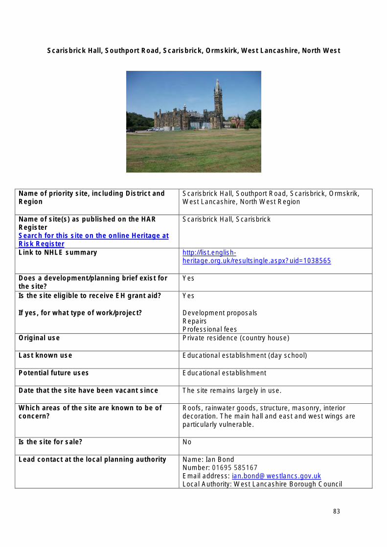
Scarisbrick Hall, Southport Road, Scarisbrick, Ormskirk, West Lancashire, North West
Name of priority site, including District and Region
Scarisbrick Hall, Southport Road, Scarisbrick, Ormskrik, West Lancashire, North West Region
Name of site(s) as published on the HAR Register Search for this site on the online Heritage at Risk Register
Scarisbrick Hall, Scarisbrick
Link to NHLE summary http://list.englishheritage.org.uk/resultsingle.aspx?uid=1038565
Does a development/planning brief exist for the site?
Yes
Is the site eligible to receive EH grant aid?
If yes, for what type of work/project?
Yes
Development proposals Repairs Professional fees
Original use Private residence (country house)
Last known use Educational establishment (day school)
Potential future uses Educational establishment
Date that the site have been vacant since The site remains largely in use.
Which areas of the site are known to be of concern?
Roofs, rainwater goods, structure, masonry, interior decoration. The main hall and east and west wings are particularly vulnerable.
Is the site for sale? No
Lead contact at the local planning authority Name: Ian Bond Number: 01695 585167 Email address: [email protected] Local Authority: West Lancashire Borough Council
83
Shieling settlement close to the mouth of Scale Beck, Loweswater, Allerdale, Cumbria, North West
Name of priority site Shieling settlement close to the mouth of Scale Beck, Loweswater, Allerdale, Cumbria, North West
Name of site(s) as published on the HAR Register Search for this site on the online Heritage at Risk Register
Shieling settlement close to the mouth of Scale Beck, Loweswater, Allerdale
Link to NHLE summary http://list.englishheritage.org.uk/resultsingle.aspx?uid=1014735
Does a development/planning brief exist for the site?
No
Is the site eligible to receive EH grant aid?
If yes, for what type of work/project?
Yes
Management Agreement
Original use Shieling
Potential future uses Low-impact sustainable visitor attraction
Date that the site has been vacant since
If in use/part use, please state
circa 1500
Which areas of the site are known to be of concern?
River bank and general area
Is the site for sale? No
Lead contact at the local planning authority Name: John Hodgson Number: 01539 792615 Email address: [email protected] Local Authority: Lake District National Park Authority
84
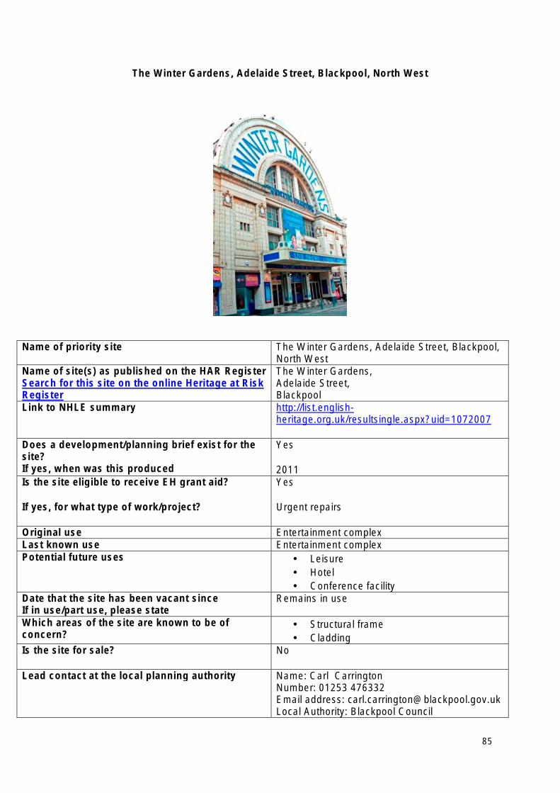
The Winter Gardens, Adelaide Street, Blackpool, North West
Name of priority site The Winter Gardens, Adelaide Street, Blackpool, North West
Name of site(s) as published on the HAR Register Search for this site on the online Heritage at Risk Register
The Winter Gardens, Adelaide Street, Blackpool
Link to NHLE summary http://list.englishheritage.org.uk/resultsingle.aspx?uid=1072007
Does a development/planning brief exist for the site? If yes, when was this produced
Yes
2011 Is the site eligible to receive EH grant aid?
If yes, for what type of work/project?
Yes
Urgent repairs
Original use Entertainment complex Last known use Entertainment complex Potential future uses • Leisure
• Hotel • Conference facility
Date that the site has been vacant since If in use/part use, please state
Remains in use
Which areas of the site are known to be of concern?
• Structural frame • Cladding
Is the site for sale? No
Lead contact at the local planning authority Name: Carl Carrington Number: 01253 476332 Email address: [email protected] Local Authority: Blackpool Council
85
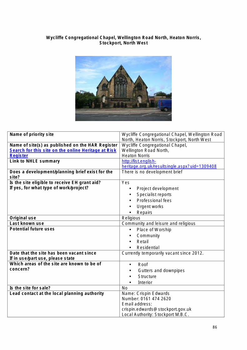
Wycliffe Congregational Chapel, Wellington Road North, Heaton Norris, Stockport, North West
Name of priority site Wycliffe Congregational Chapel, Wellington Road North, Heaton Norris, Stockport, North West
Name of site(s) as published on the HAR Register Search for this site on the online Heritage at Risk Register
Wycliffe Congregational Chapel, Wellington Road North, Heaton Norris
Link to NHLE summary http://list.englishheritage.org.uk/resultsingle.aspx?uid=1309408
Does a development/planning brief exist for the site?
There is no development brief
Is the site eligible to receive EH grant aid? If yes, for what type of work/project?
Yes • Project development • Specialist reports • Professional fees • Urgent works • Repairs
Original use Religious Last known use Community and leisure and religious Potential future uses • Place of Worship
• Community • Retail • Residential
Date that the site has been vacant since If in use/part use, please state
Currently temporarily vacant since 2012.
Which areas of the site are known to be of concern?
• Roof • Gutters and downpipes • Structure • Interior
Is the site for sale? No Lead contact at the local planning authority Name: Crispin Edwards
Number: 0161 474 2620 Email address: [email protected] Local Authority: Stockport M.B.C.
86
South East Heritage at Risk Priority Sites 2013
• Brookwood Cemetery, Brookwood, Woking, Surrey
• Castle Goring, Arundel Road, Worthing, West Sussex
• Hammerhead Crane, Thetis Road, West Cowes, Cowes, Isle of Wight
• RAF Bicester: World War II airfield, Laughton, Cherwell, Oxfordshire
• Roman Catholic Church of St Augustine of England with Cloisters attached, St Augustine’s Road, Ramsgate, Thanet, Kent
• Sheerness Dockyard (incl.The Boat Store (No. 78), Former Medway Ports Authority Offices (Dockyard House),Coach Houses (Naval Terrace), 1-15 (consec) Regency Close, Former Royal Dockyard Church and attached wall and railings, Former Working Mast House, 26 Jetty Road), Sheerness, Kent
• Stowe Landscape Garden (incl. The Palladian Bridge, Temple of Friendship, The East Boycott Pavilion and The Queens Temple), Stowe, Buckinghamshire
• The Belvedere, Waldershare Park, Shepherdswell with Coldred, Dover, Kent
• The chapel at the former King Edward VII Hospital, Easebourne, Chichester, West Sussex
• The Western Heights fortifications, Castle Hill, Dover, Kent
87
Brookwood Cemetery, Brookwood, Woking, Surrey, South East
Name of priority site Brookwood Cemetery, Brookwood, Woking, Surrey, South East
Name of site(s) as published on the HAR Register Search for this site on the online Heritage at Risk Register
Brookwood Cemetery, Brookwood
Link to NHLE summary http://list.englishheritage.org.uk/resultsingle.aspx?uid=1001265
Does a development/planning brief exist for the site?
No
Is the site eligible to receive EH grant aid?
If yes, for what type of work/project?
Yes - £100k offered 2010
• Conservation management plan • Repairs
Original use As now
Last known use
Potential future uses As now
Date that the site has been vacant since
If in use/part use, please state
N/A
Which areas of the site are known to be of concern?
The neglect and lack of general management of some areas (e.g. problems with ground water) plus specific monuments (not all yet identified).
Is the site for sale? No
Lead contact at the local planning authority Name: Peter Welvaert Number: 01483 743045 Email address: [email protected] Local Authority: Woking Borough Council
88
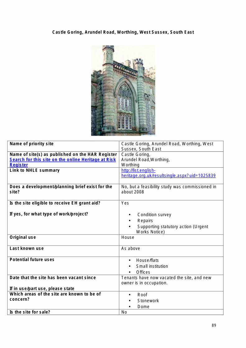
Castle Goring, Arundel Road, Worthing, West Sussex, South East
Name of priority site Castle Goring, Arundel Road, Worthing, West Sussex, South East
Name of site(s) as published on the HAR Register Search for this site on the online Heritage at Risk Register
Castle Goring, Arundel Road,Worthing, Worthing
Link to NHLE summary http://list.englishheritage.org.uk/resultsingle.aspx?uid=1025839
Does a development/planning brief exist for the site?
No, but a feasibility study was commissioned in about 2008
Is the site eligible to receive EH grant aid?
If yes, for what type of work/project?
Yes
• Condition survey • Repairs • Supporting statutory action (Urgent
Works Notice) Original use House
Last known use As above
Potential future uses • House/flats • Small institution • Offices
Date that the site has been vacant since
If in use/part use, please state
Tenants have now vacated the site, and new owner is in occupation.
Which areas of the site are known to be of concern?
• Roof • Stonework • Dome
Is the site for sale? No
89

Lead contact at the local planning authority Name: Richard Small Number: 01903 221363 Email address: [email protected] Local Authority: Worthing Borough Council
And: Name: David Boyson Number: 01730 811747 Email add: [email protected] Local Authority: South Downs National Park Authority
90
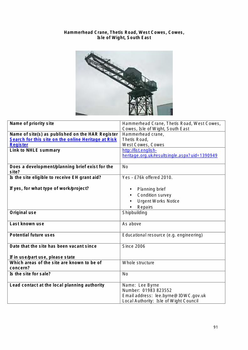
Hammerhead Crane, Thetis Road, West Cowes, Cowes, Isle of Wight, South East
Name of priority site Hammerhead Crane, Thetis Road, West Cowes, Cowes, Isle of Wight, South East
Name of site(s) as published on the HAR Register Search for this site on the online Heritage at Risk Register
Hammerhead crane, Thetis Road, West Cowes, Cowes
Link to NHLE summary http://list.englishheritage.org.uk/resultsingle.aspx?uid=1390949
Does a development/planning brief exist for the site?
No
Is the site eligible to receive EH grant aid?
If yes, for what type of work/project?
Yes - £76k offered 2010.
• Planning brief • Condition survey • Urgent Works Notice • Repairs
Original use Shipbuilding
Last known use As above
Potential future uses Educational resource (e.g. engineering)
Date that the site has been vacant since
If in use/part use, please state
Since 2006
Which areas of the site are known to be of concern?
Whole structure
Is the site for sale? No
Lead contact at the local planning authority Name: Lee Byrne Number: 01983 823552 Email address: [email protected] Local Authority: Isle of Wight Council
91
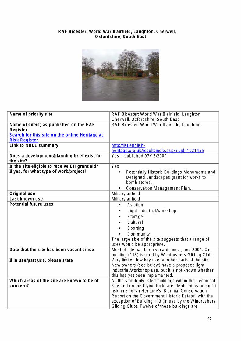
RAF Bicester: World War II airfield, Laughton, Cherwell, Oxfordshire, South East
Name of priority site RAF Bicester: World War II airfield, Laughton, Cherwell, Oxfordshire, South East
Name of site(s) as published on the HAR Register Search for this site on the online Heritage at Risk Register
RAF Bicester: World War II airfield, Laughton
Link to NHLE summary http://list.englishheritage.org.uk/resultsingle.aspx?uid=1021455
Does a development/planning brief exist for the site?
Yes – published 07/12/2009
Is the site eligible to receive EH grant aid? If yes, for what type of work/project?
Yes • Potentially Historic Buildings Monuments and
Designed Landscapes grant for works to bomb stores.
• Conservation Management Plan. Original use Military airfield Last known use Military airfield Potential future uses • Aviation
• Light industrial/workshop • Storage • Cultural • Sporting • Community
The large size of the site suggests that a range of uses would be appropriate.
Date that the site has been vacant since
If in use/part use, please state
Most of site has been vacant since June 2004. One building (113) is used by Windrushers Gliding Club. Very limited low key use on other parts of the site. New owners (see below) have a proposed light industrial/workshop use, but it is not known whether this has yet been implemented.
Which areas of the site are known to be of concern?
All the statutorily listed buildings within the Technical Site and on the Flying Field are identified as being ‘at risk’ in English Heritage’s ‘Biennial Conservation Report on the Government Historic Estate’, with the exception of Building 113 (in use by the Windrushers Gliding Club). Twelve of these buildings are
92
identified as Category A - ‘Immediate risk of further, rapid deterioration or loss of fabric; no solution agreed’; the other six buildings are identified as Category C – ‘slow decay; no solution agreed’. Scheduled bomb stores are on Heritage at Risk Register
Is the site for sale? No. The site was sold by MOD on 27/03/2013 to Bicester Heritage Limited. It is understood that BHL propose to use it for the repair of vintage aircraft and cars.
Lead contact at the local planning authority Name: Linda Rand Number: 01295 221846 Email address: [email protected] Local Authority: Cherwell District Council
93
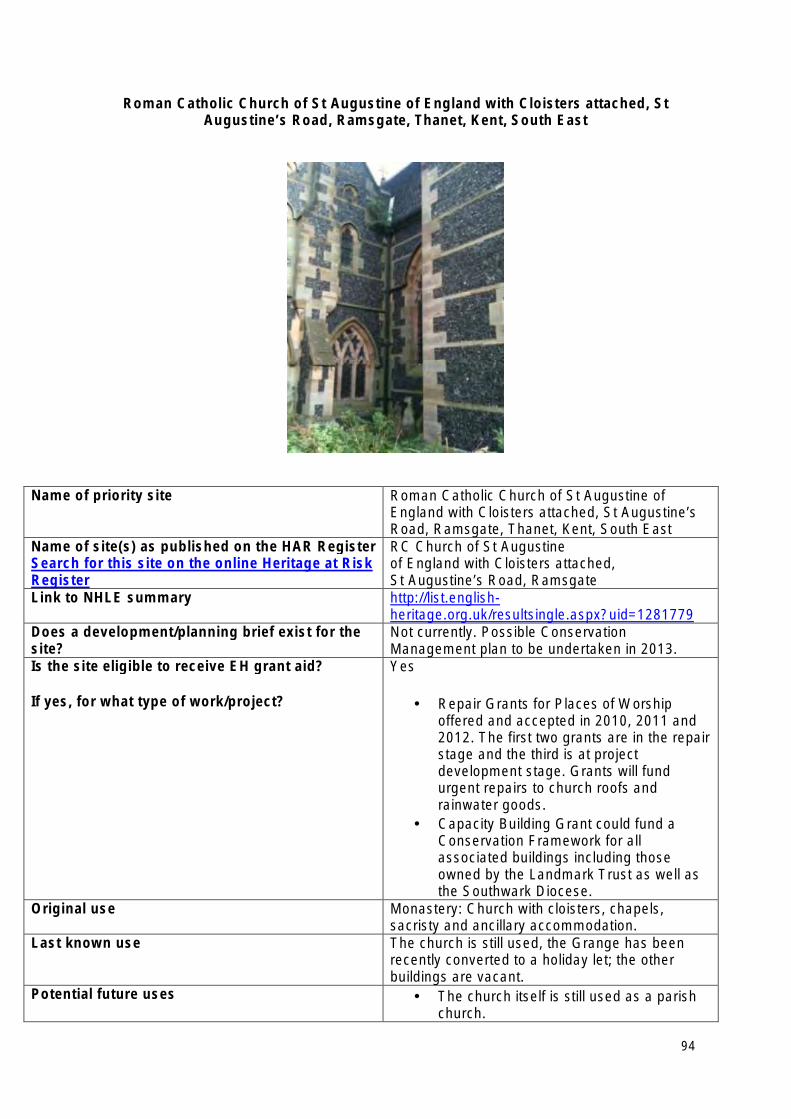
Roman Catholic Church of St Augustine of England with Cloisters attached, St Augustine’s Road, Ramsgate, Thanet, Kent, South East
Name of priority site Roman Catholic Church of St Augustine of England with Cloisters attached, St Augustine’s Road, Ramsgate, Thanet, Kent, South East
Name of site(s) as published on the HAR Register Search for this site on the online Heritage at Risk Register
RC Church of St Augustine of England with Cloisters attached, St Augustine’s Road, Ramsgate
Link to NHLE summary http://list.englishheritage.org.uk/resultsingle.aspx?uid=1281779
Does a development/planning brief exist for the site?
Not currently. Possible Conservation Management plan to be undertaken in 2013.
Is the site eligible to receive EH grant aid?
If yes, for what type of work/project?
Yes
• Repair Grants for Places of Worship offered and accepted in 2010, 2011 and 2012. The first two grants are in the repair stage and the third is at project development stage. Grants will fund urgent repairs to church roofs and rainwater goods.
• Capacity Building Grant could fund a Conservation Framework for all associated buildings including those owned by the Landmark Trust as well as the Southwark Diocese.
Original use Monastery: Church with cloisters, chapels, sacristy and ancillary accommodation.
Last known use The church is still used, the Grange has been recently converted to a holiday let; the other buildings are vacant.
Potential future uses • The church itself is still used as a parish church.
94
• The Grange is now a Landmark Trust holiday let
• St Edward’s Presbytery has been bought by the Landmark Trust but future use is as yet unknown.
• Unknown potential uses for remaining buildings at present.
Date that the site has been vacant since
If in use/part use, please state
The church remains in use; other buildings became vacant in 2010 when the monks departed.
Which areas of the site are known to be of concern?
The Church of St Augustine (see above)
Is the site for sale? No
Lead contact at the local planning authority Name: Nick Dermott (Conservation Officer) Number: 01843 577000 Email address: [email protected] Local Authority: Thanet District Council
95
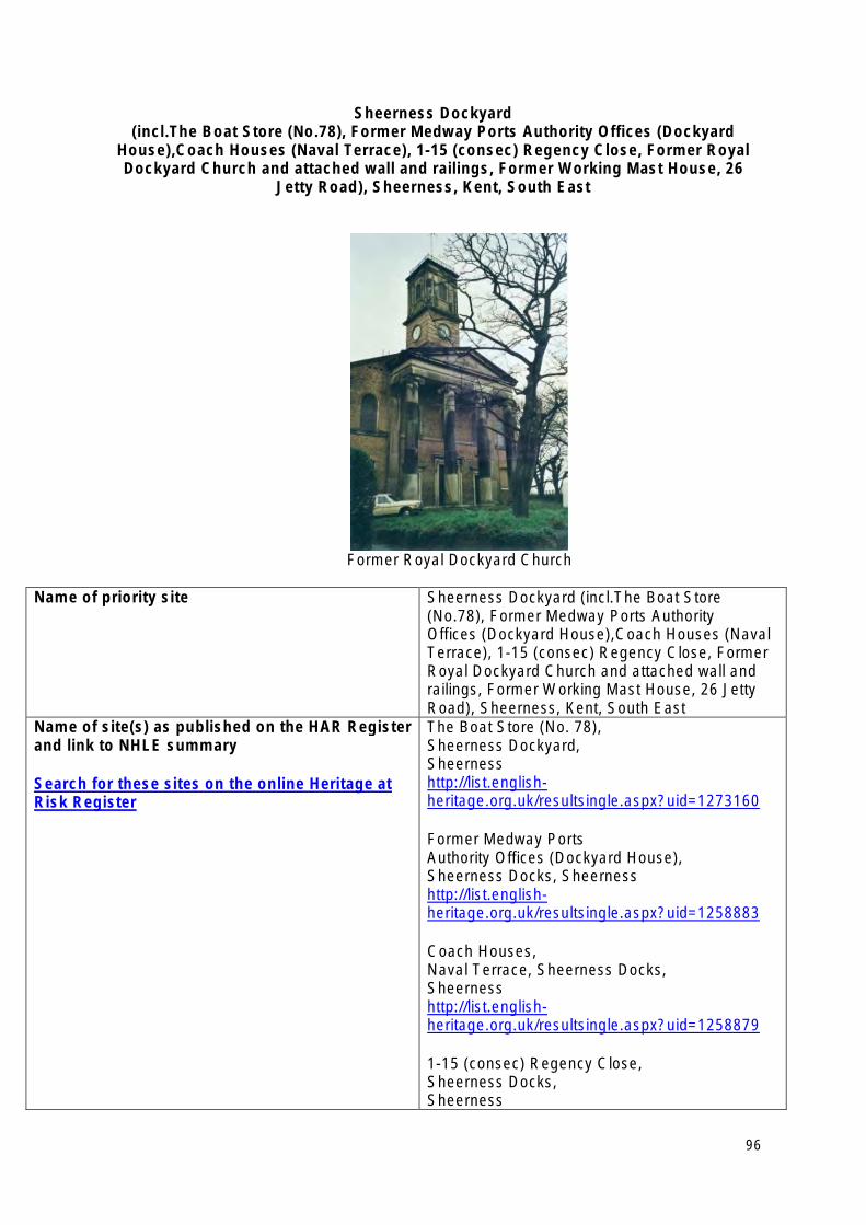
Sheerness Dockyard (incl.The Boat Store (No.78), Former Medway Ports Authority Offices (Dockyard
House),Coach Houses (Naval Terrace), 1-15 (consec) Regency Close, Former Royal Dockyard Church and attached wall and railings, Former Working Mast House, 26
Jetty Road), Sheerness, Kent, South East
Former Royal Dockyard Church
Name of priority site Sheerness Dockyard (incl.The Boat Store (No.78), Former Medway Ports Authority Offices (Dockyard House),Coach Houses (Naval Terrace), 1-15 (consec) Regency Close, Former Royal Dockyard Church and attached wall and railings, Former Working Mast House, 26 Jetty Road), Sheerness, Kent, South East
Name of site(s) as published on the HAR Register The Boat Store (No. 78), and link to NHLE summary Sheerness Dockyard,
Sheerness Search for these sites on the online Heritage at http://list.english-Risk Register heritage.org.uk/resultsingle.aspx?uid=1273160
Former Medway Ports Authority Offices (Dockyard House), Sheerness Docks, Sheerness http://list.englishheritage.org.uk/resultsingle.aspx?uid=1258883
Coach Houses, Naval Terrace, Sheerness Docks, Sheerness http://list.englishheritage.org.uk/resultsingle.aspx?uid=1258879
1-15 (consec) Regency Close, Sheerness Docks, Sheerness
96
http://list.englishheritage.org.uk/resultsingle.aspx?uid=1258881
Former Royal Dockyard Church and attached wall and railings, Sheerness Dockyard, Sheerness
http://list.englishheritage.org.uk/resultsingle.aspx?uid=1273239
Former Working Mast House, 26 Jetty Road, Sheerness Dockyard, Sheerness http://list.englishheritage.org.uk/resultsingle.aspx?uid=1244509
Does a development/planning brief exist for the • Feasibility Study for the Former Royal site? Dockyard Church was carried out (2011 –
2012). • Peel (owners) have had some survey
If yes, when was this produced work done. Is the site eligible to receive EH grant aid?
If yes, for what type of work/project?
Yes
• Former Royal Dockyard Church – grant towards Compulsory Purchase Order legal fees.
• Former Royal Dockyard Church – grant towards production of a feasibility study.
Original use Dockyard
Last known use Dockyard (partial use, historic buildings are at risk).
Potential future uses • Former Royal Dockyard Church – possible future arts centre.
• Remaining dockyard buildings – future uses uncertain.
Date that the site has been vacant since
If in use/part use, please state
Unknown
Some parts still in use. Which areas of the site are known to be of concern?
• All areas of the historic dockyard are of great concern
Is the site for sale? No
Lead contact at the local planning authority Name: Peter Bell (Design & Conservation) Number: 01795 424341 Email address: [email protected] Local Authority: Swale Borough Council
97
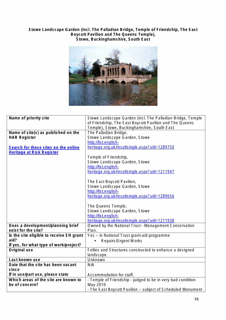
Stowe Landscape Garden (incl. The Palladian Bridge, Temple of Friendship, The East Boycott Pavilion and The Queens Temple),
Stowe, Buckinghamshire, South East
Name of priority site Stowe Landscape Garden (incl. The Palladian Bridge, Temple of Friendship, The East Boycott Pavilion and The Queens Temple), Stowe, Buckinghamshire, South East
Name of site(s) as published on the HAR Register
Search for these sites on the online Heritage at Risk Register
The Palladian Bridge, Stowe Landscape Garden, Stowe http://list.englishheritage.org.uk/resultsingle.aspx?uid=1289750
Temple of Friendship, Stowe Landscape Garden, Stowe http://list.englishheritage.org.uk/resultsingle.aspx?uid=1211947
The East Boycott Pavilion, Stowe Landscape Garden, Stowe http://list.englishheritage.org.uk/resultsingle.aspx?uid=1289656
The Queens Temple, Stowe Landscape Garden, Stowe http://list.englishheritage.org.uk/resultsingle.aspx?uid=1211938
Does a development/planning brief exist for the site?
Owned by the National Trust - Management Conservation Plan.
Is the site eligible to receive EH grant aid? If yes, for what type of work/project?
Yes – in National Trust grant-aid programme • Repairs/Urgent Works
Original use Follies and Structures constructed to enhance a designed landscape.
Last known use Unknown Date that the site has been vacant since If in use/part use, please state
N/A
Accommodation for staff. Which areas of the site are known to be of concern?
- Temple of Friendship - judged to be in very bad condition May 2010 - The East Boycott Pavilion – subject of Scheduled Monument
98

Consent February 2011 for removal of cupola and urgent repairs to dome.
Is the site for sale? No Lead contact at the local planning authority
Name: Mrs S Pilcher/Claire Pudney Number: 01296 585413 Email address: [email protected] Local Authority: Aylesbury Vale District Council
99
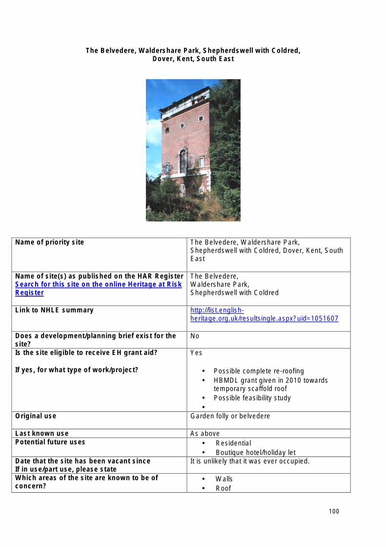
The Belvedere, Waldershare Park, Shepherdswell with Coldred, Dover, Kent, South East
Name of priority site The Belvedere, Waldershare Park, Shepherdswell with Coldred, Dover, Kent, South East
Name of site(s) as published on the HAR Register Search for this site on the online Heritage at Risk Register
The Belvedere, Waldershare Park, Shepherdswell with Coldred
Link to NHLE summary http://list.englishheritage.org.uk/resultsingle.aspx?uid=1051607
Does a development/planning brief exist for the site?
No
Is the site eligible to receive EH grant aid?
If yes, for what type of work/project?
Yes
• Possible complete re-roofing • HBMDL grant given in 2010 towards
temporary scaffold roof • Possible feasibility study •
Original use Garden folly or belvedere
Last known use As above Potential future uses • Residential
• Boutique hotel/holiday let Date that the site has been vacant since If in use/part use, please state
It is unlikely that it was ever occupied.
Which areas of the site are known to be of concern?
• Walls • Roof
100

• All internal structure Is the site for sale? No
Lead contact at the local planning authority Name: Clive Alexander Number: 01304 872480 Email address:[email protected] Local Authority: Dover District Council
101
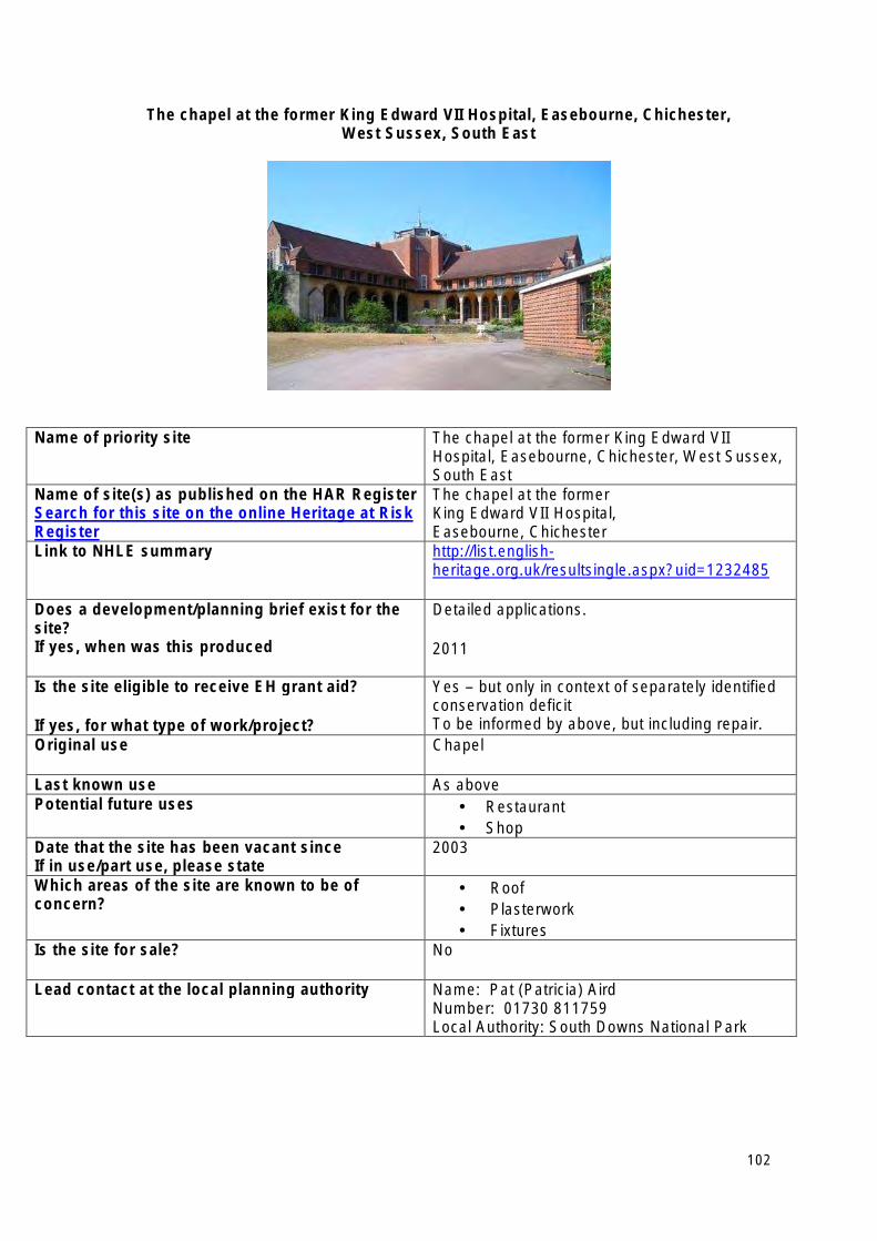
The chapel at the former King Edward VII Hospital, Easebourne, Chichester, West Sussex, South East
Name of priority site The chapel at the former King Edward VII Hospital, Easebourne, Chichester, West Sussex, South East
Name of site(s) as published on the HAR Register Search for this site on the online Heritage at Risk Register
The chapel at the former King Edward VII Hospital, Easebourne, Chichester
Link to NHLE summary http://list.englishheritage.org.uk/resultsingle.aspx?uid=1232485
Does a development/planning brief exist for the site? If yes, when was this produced
Detailed applications.
2011
Is the site eligible to receive EH grant aid?
If yes, for what type of work/project?
Yes – but only in context of separately identified conservation deficit To be informed by above, but including repair.
Original use Chapel
Last known use As above Potential future uses • Restaurant
• Shop Date that the site has been vacant since If in use/part use, please state
2003
Which areas of the site are known to be of concern?
• Roof • Plasterwork • Fixtures
Is the site for sale? No
Lead contact at the local planning authority Name: Pat (Patricia) Aird Number: 01730 811759 Local Authority: South Downs National Park
102
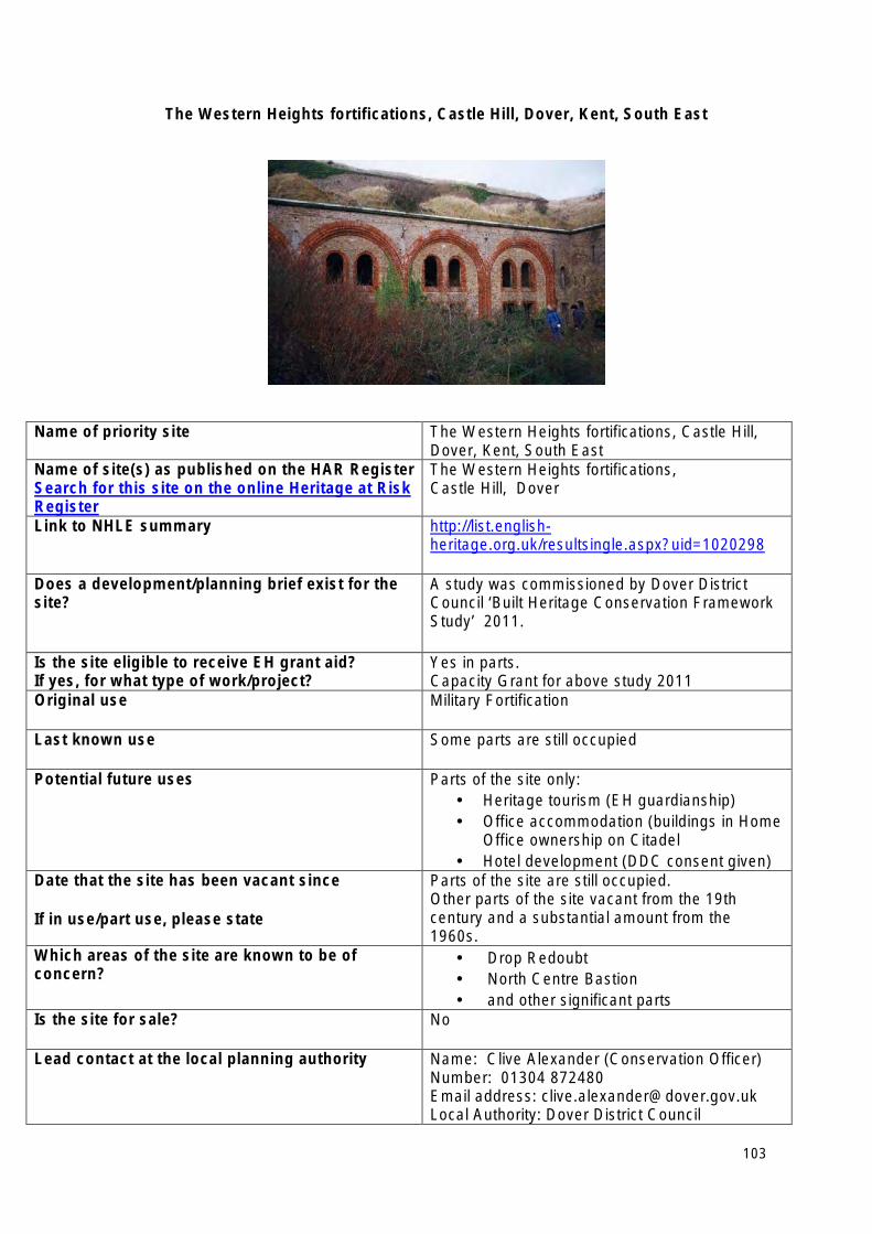
The Western Heights fortifications, Castle Hill, Dover, Kent, South East
Name of priority site The Western Heights fortifications, Castle Hill, Dover, Kent, South East
Name of site(s) as published on the HAR Register Search for this site on the online Heritage at Risk Register
The Western Heights fortifications, Castle Hill, Dover
Link to NHLE summary http://list.englishheritage.org.uk/resultsingle.aspx?uid=1020298
Does a development/planning brief exist for the site?
A study was commissioned by Dover District Council ‘Built Heritage Conservation Framework Study’ 2011.
Is the site eligible to receive EH grant aid? If yes, for what type of work/project?
Yes in parts. Capacity Grant for above study 2011
Original use Military Fortification
Last known use Some parts are still occupied
Potential future uses Parts of the site only: • Heritage tourism (EH guardianship) • Office accommodation (buildings in Home
Office ownership on Citadel • Hotel development (DDC consent given)
Date that the site has been vacant since
If in use/part use, please state
Parts of the site are still occupied. Other parts of the site vacant from the 19th century and a substantial amount from the 1960s.
Which areas of the site are known to be of concern?
• Drop Redoubt • North Centre Bastion • and other significant parts
Is the site for sale? No
Lead contact at the local planning authority Name: Clive Alexander (Conservation Officer) Number: 01304 872480 Email address: [email protected] Local Authority: Dover District Council
103
South West Heritage at Risk Priority Sites 2013
• Academy Theatre and Great Western Hotel (Palace Theatre), Union Street, Stonehouse, Plymouth
• Birnbeck Pier, Weston-Super-Mare, North Somerset
• Carriage Works, 104 Stokes Croft, Bristol
• Cloth finishing works at Tone Mills, north range, Langford Budville, Taunton Deane, Somerset
• Former Saxon church to west of Priory House, Leonard Stanley, Stroud, Gloucestershire
• Grenville Battery 550yds (500m) SSW of Maker Farm, Maker-with-Rame, Cornwall
• Guns Mill Barn, Littledean, Forest of Dean, Gloucestershire
• Medieval moated site and Romano-British settlement at White Walls Wood, Easton Grey, Wiltshire
• The Mechanics Institute, Emlyn Square, Swindon
• Torbay Cinema, Torbay Road, Paignton, Torbay
104
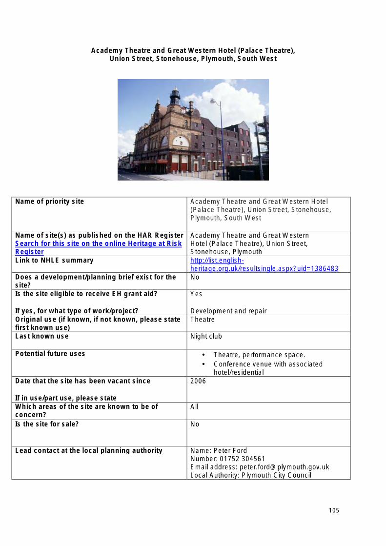
Academy Theatre and Great Western Hotel (Palace Theatre), Union Street, Stonehouse, Plymouth, South West
Name of priority site Academy Theatre and Great Western Hotel (Palace Theatre), Union Street, Stonehouse, Plymouth, South West
Name of site(s) as published on the HAR Register Search for this site on the online Heritage at Risk Register
Academy Theatre and Great Western Hotel (Palace Theatre), Union Street, Stonehouse, Plymouth
Link to NHLE summary http://list.englishheritage.org.uk/resultsingle.aspx?uid=1386483
Does a development/planning brief exist for the site?
No
Is the site eligible to receive EH grant aid?
If yes, for what type of work/project?
Yes
Development and repair Original use (if known, if not known, please state first known use)
Theatre
Last known use Night club
Potential future uses • Theatre, performance space. • Conference venue with associated
hotel/residential Date that the site has been vacant since
If in use/part use, please state
2006
Which areas of the site are known to be of concern?
All
Is the site for sale? No
Lead contact at the local planning authority Name: Peter Ford Number: 01752 304561 Email address: [email protected] Local Authority: Plymouth City Council
105
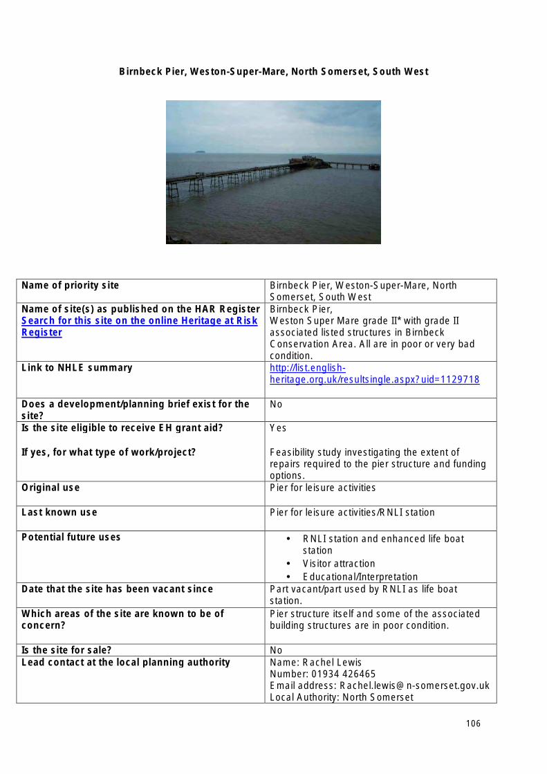
Birnbeck Pier, Weston-Super-Mare, North Somerset, South West
Name of priority site Birnbeck Pier, Weston-Super-Mare, North Somerset, South West
Name of site(s) as published on the HAR Register Search for this site on the online Heritage at Risk Register
Birnbeck Pier, Weston Super Mare grade II* with grade II associated listed structures in Birnbeck Conservation Area. All are in poor or very bad condition.
Link to NHLE summary http://list.englishheritage.org.uk/resultsingle.aspx?uid=1129718
Does a development/planning brief exist for the site?
No
Is the site eligible to receive EH grant aid?
If yes, for what type of work/project?
Yes
Feasibility study investigating the extent of repairs required to the pier structure and funding options.
Original use Pier for leisure activities
Last known use Pier for leisure activities/RNLI station
Potential future uses • RNLI station and enhanced life boat station
• Visitor attraction • Educational/Interpretation
Date that the site has been vacant since Part vacant/part used by RNLI as life boat station.
Which areas of the site are known to be of concern?
Pier structure itself and some of the associated building structures are in poor condition.
Is the site for sale? No Lead contact at the local planning authority Name: Rachel Lewis
Number: 01934 426465 Email address: [email protected] Local Authority: North Somerset
106
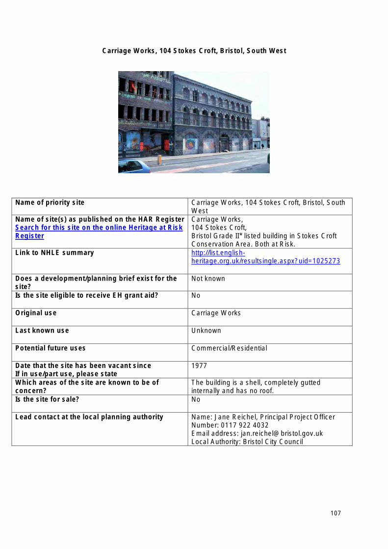
Carriage Works, 104 Stokes Croft, Bristol, South West
Name of priority site Carriage Works, 104 Stokes Croft, Bristol, South West
Name of site(s) as published on the HAR Register Search for this site on the online Heritage at Risk Register
Carriage Works, 104 Stokes Croft, Bristol Grade II* listed building in Stokes Croft Conservation Area. Both at Risk.
Link to NHLE summary http://list.englishheritage.org.uk/resultsingle.aspx?uid=1025273
Does a development/planning brief exist for the site?
Not known
Is the site eligible to receive EH grant aid? No
Original use Carriage Works
Last known use Unknown
Potential future uses Commercial/Residential
Date that the site has been vacant since If in use/part use, please state
1977
Which areas of the site are known to be of concern?
The building is a shell, completely gutted internally and has no roof.
Is the site for sale? No
Lead contact at the local planning authority Name: Jane Reichel, Principal Project Officer Number: 0117 922 4032 Email address: [email protected] Local Authority: Bristol City Council
107
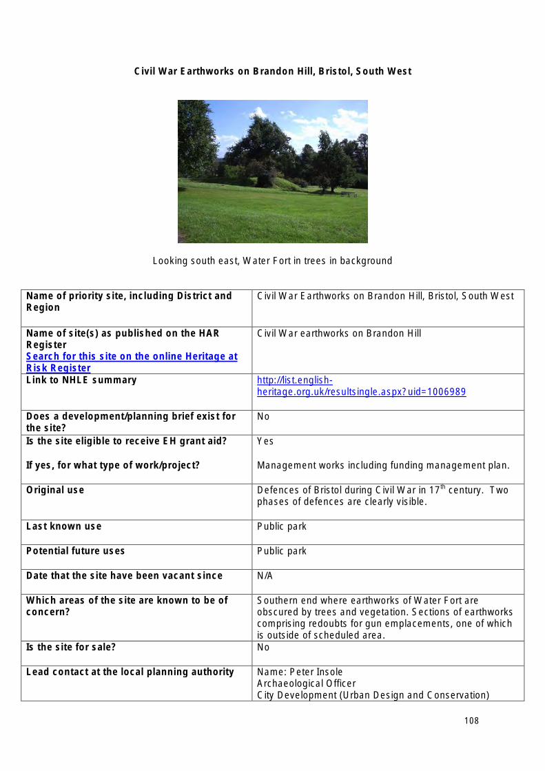
Civil War Earthworks on Brandon Hill, Bristol, South West
Looking south east, Water Fort in trees in background
Name of priority site, including District and Region
Civil War Earthworks on Brandon Hill, Bristol, South West
Name of site(s) as published on the HAR Register Search for this site on the online Heritage at Risk Register
Civil War earthworks on Brandon Hill
Link to NHLE summary http://list.englishheritage.org.uk/resultsingle.aspx?uid=1006989
Does a development/planning brief exist for the site?
No
Is the site eligible to receive EH grant aid?
If yes, for what type of work/project?
Yes
Management works including funding management plan.
Original use Defences of Bristol during Civil War in 17th century. Two phases of defences are clearly visible.
Last known use Public park
Potential future uses Public park
Date that the site have been vacant since N/A
Which areas of the site are known to be of concern?
Southern end where earthworks of Water Fort are obscured by trees and vegetation. Sections of earthworks comprising redoubts for gun emplacements, one of which is outside of scheduled area.
Is the site for sale? No
Lead contact at the local planning authority Name: Peter Insole Archaeological Officer City Development (Urban Design and Conservation)
108

Neighbourhoods and City Development Email: [email protected] Local Authority: Bristol City Council Brunel House St.Georges Road Bristol, BS1 5UY
Tel: 0117 9223033 Fax: 0117 9224637
109
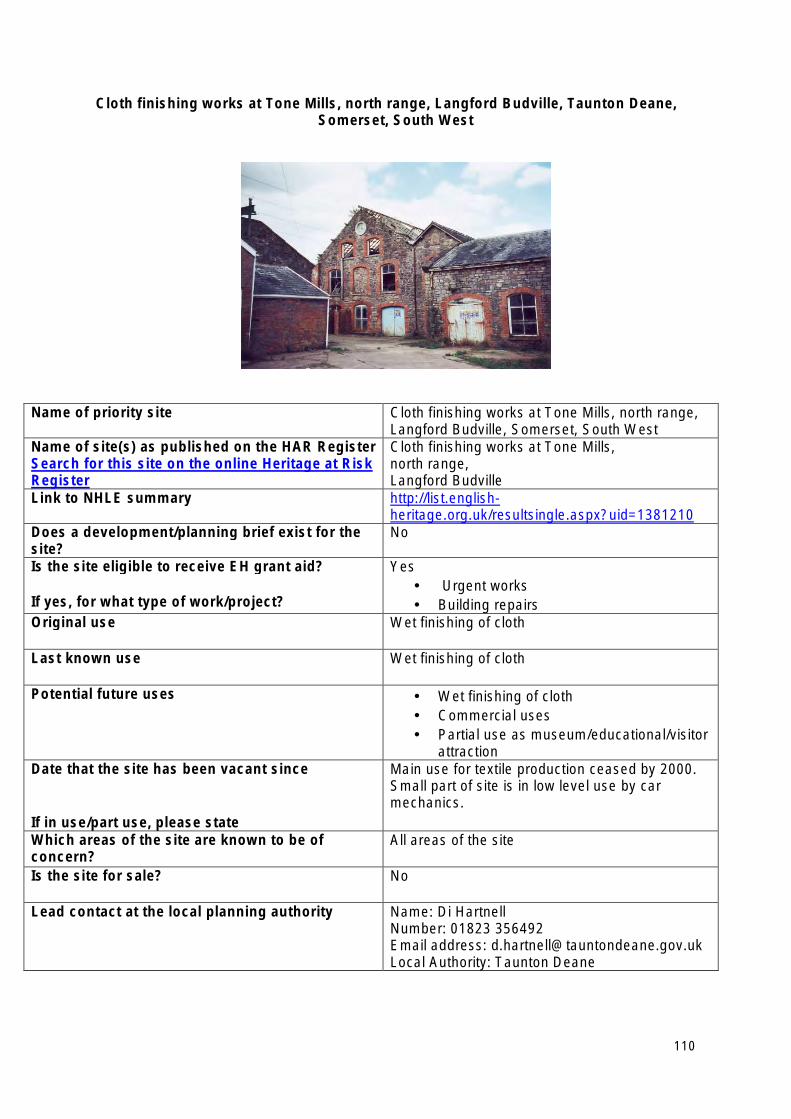
Cloth finishing works at Tone Mills, north range, Langford Budville, Taunton Deane, Somerset, South West
Name of priority site Cloth finishing works at Tone Mills, north range, Langford Budville, Somerset, South West
Name of site(s) as published on the HAR Register Search for this site on the online Heritage at Risk Register
Cloth finishing works at Tone Mills, north range, Langford Budville
Link to NHLE summary http://list.englishheritage.org.uk/resultsingle.aspx?uid=1381210
Does a development/planning brief exist for the site?
No
Is the site eligible to receive EH grant aid?
If yes, for what type of work/project?
Yes • Urgent works • Building repairs
Original use Wet finishing of cloth
Last known use Wet finishing of cloth
Potential future uses • Wet finishing of cloth • Commercial uses • Partial use as museum/educational/visitor
attraction Date that the site has been vacant since
If in use/part use, please state
Main use for textile production ceased by 2000. Small part of site is in low level use by car mechanics.
Which areas of the site are known to be of concern?
All areas of the site
Is the site for sale? No
Lead contact at the local planning authority Name: Di Hartnell Number: 01823 356492 Email address: [email protected] Local Authority: Taunton Deane
110
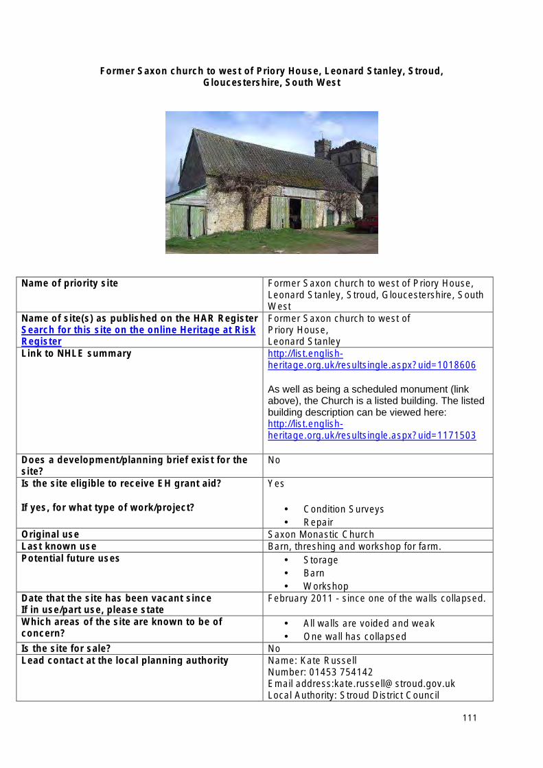
Former Saxon church to west of Priory House, Leonard Stanley, Stroud, Gloucestershire, South West
Name of priority site Former Saxon church to west of Priory House, Leonard Stanley, Stroud, Gloucestershire, South West
Name of site(s) as published on the HAR Register Search for this site on the online Heritage at Risk Register
Former Saxon church to west of Priory House, Leonard Stanley
Link to NHLE summary http://list.englishheritage.org.uk/resultsingle.aspx?uid=1018606
As well as being a scheduled monument (link above), the Church is a listed building. The listed building description can be viewed here: http://list.englishheritage.org.uk/resultsingle.aspx?uid=1171503
Does a development/planning brief exist for the site?
No
Is the site eligible to receive EH grant aid?
If yes, for what type of work/project?
Yes
• Condition Surveys • Repair
Original use Saxon Monastic Church Last known use Barn, threshing and workshop for farm. Potential future uses • Storage
• Barn • Workshop
Date that the site has been vacant since If in use/part use, please state
February 2011 - since one of the walls collapsed.
Which areas of the site are known to be of concern?
• All walls are voided and weak • One wall has collapsed
Is the site for sale? No Lead contact at the local planning authority Name: Kate Russell
Number: 01453 754142 Email address:[email protected] Local Authority: Stroud District Council
111
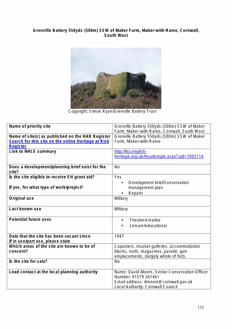
Grenville Battery 550yds (500m) SSW of Maker Farm, Maker-with-Rame, Cornwall, South West
Copyright: Simon Ryan/Grenville Battery Trust
Name of priority site Grenville Battery 550yds (500m) SSW of Maker Farm, Maker-with-Rame, Cornwall, South West
Name of site(s) as published on the HAR Register Search for this site on the online Heritage at Risk Register
Grenville Battery 550yds (500m) SSW of Maker Farm, Maker-with-Rame
Link to NHLE summary http://list.englishheritage.org.uk/resultsingle.aspx?uid=1003114
Does a development/planning brief exist for the site?
No
Is the site eligible to receive EH grant aid?
If yes, for what type of work/project?
Yes • Development brief/conservation
management plan • Repairs
Original use Military
Last known use Military
Potential future uses • Theatre/creative • Leisure/educational
Date that the site has been vacant since If in use/part use, please state
1947
Which areas of the site are known to be of concern?
Caponiers, musket galleries, accommodation blocks, roofs, magazines, parade, gun emplacements, (largely whole of fort).
Is the site for sale? No
Lead contact at the local planning authority Name: David Moore, Senior Conservation Officer Number: 01579 341461 Email address: [email protected] Local Authority: Cornwall Council
112
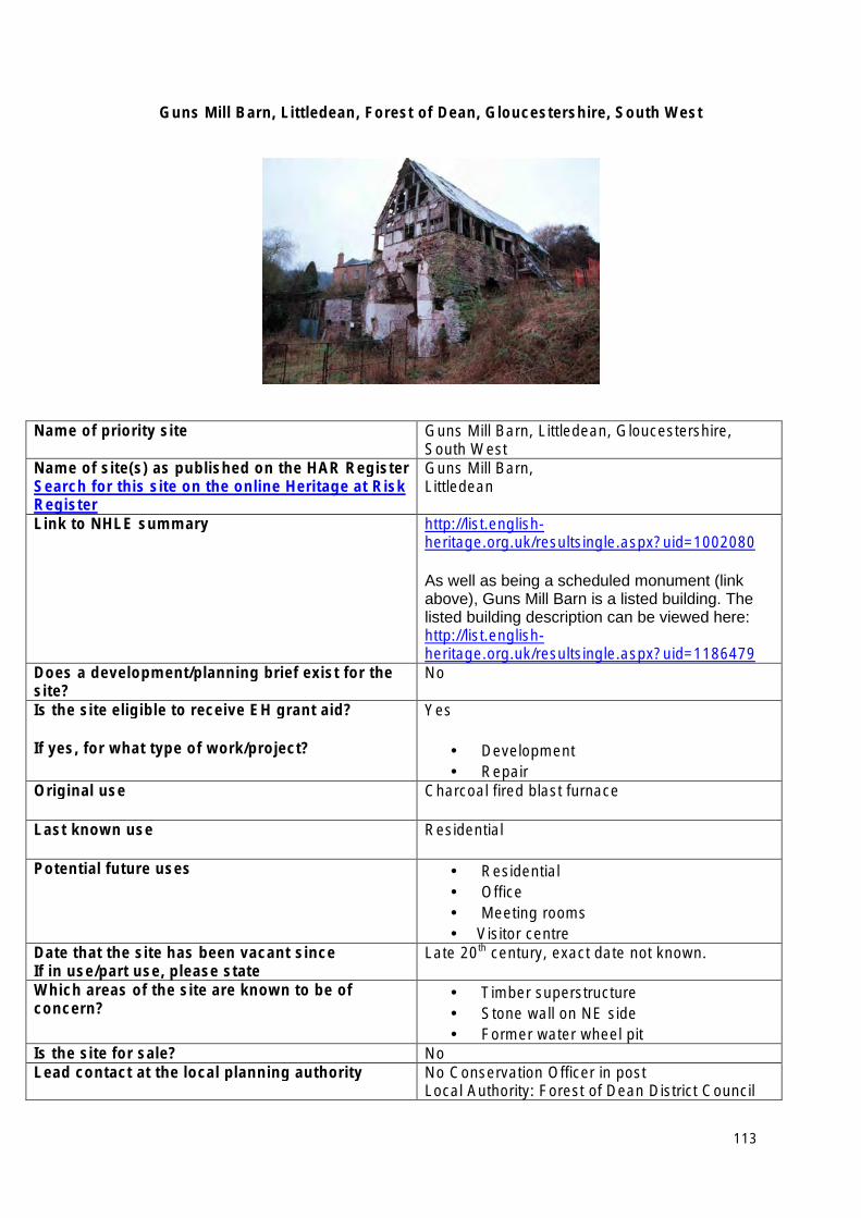
Guns Mill Barn, Littledean, Forest of Dean, Gloucestershire, South West
Name of priority site Guns Mill Barn, Littledean, Gloucestershire, South West
Name of site(s) as published on the HAR Register Search for this site on the online Heritage at Risk Register
Guns Mill Barn, Littledean
Link to NHLE summary http://list.englishheritage.org.uk/resultsingle.aspx?uid=1002080
As well as being a scheduled monument (link above), Guns Mill Barn is a listed building. The listed building description can be viewed here: http://list.englishheritage.org.uk/resultsingle.aspx?uid=1186479
Does a development/planning brief exist for the site?
No
Is the site eligible to receive EH grant aid?
If yes, for what type of work/project?
Yes
• Development • Repair
Original use Charcoal fired blast furnace
Last known use Residential
Potential future uses • Residential • Office • Meeting rooms • Visitor centre
Date that the site has been vacant since If in use/part use, please state
Late 20th century, exact date not known.
Which areas of the site are known to be of concern?
• Timber superstructure • Stone wall on NE side • Former water wheel pit
Is the site for sale? No Lead contact at the local planning authority No Conservation Officer in post
Local Authority: Forest of Dean District Council
113
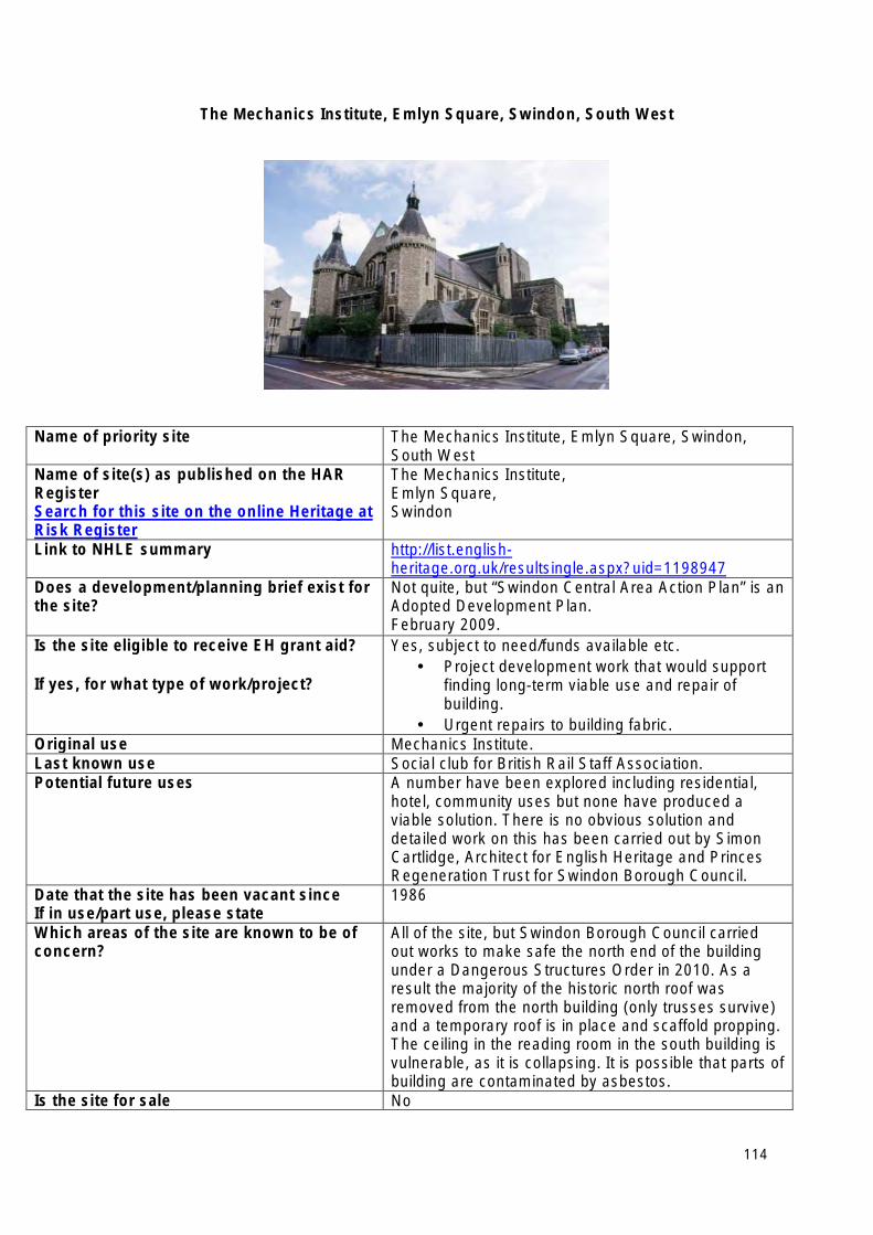
The Mechanics Institute, Emlyn Square, Swindon, South West
Name of priority site The Mechanics Institute, Emlyn Square, Swindon, South West
Name of site(s) as published on the HAR Register Search for this site on the online Heritage at Risk Register
The Mechanics Institute, Emlyn Square, Swindon
Link to NHLE summary http://list.englishheritage.org.uk/resultsingle.aspx?uid=1198947
Does a development/planning brief exist for the site?
Not quite, but “Swindon Central Area Action Plan” is an Adopted Development Plan. February 2009.
Is the site eligible to receive EH grant aid?
If yes, for what type of work/project?
Yes, subject to need/funds available etc. • Project development work that would support
finding long-term viable use and repair of building.
• Urgent repairs to building fabric. Original use Mechanics Institute. Last known use Social club for British Rail Staff Association. Potential future uses A number have been explored including residential,
hotel, community uses but none have produced a viable solution. There is no obvious solution and detailed work on this has been carried out by Simon Cartlidge, Architect for English Heritage and Princes Regeneration Trust for Swindon Borough Council.
Date that the site has been vacant since If in use/part use, please state
1986
Which areas of the site are known to be of concern?
All of the site, but Swindon Borough Council carried out works to make safe the north end of the building under a Dangerous Structures Order in 2010. As a result the majority of the historic north roof was removed from the north building (only trusses survive) and a temporary roof is in place and scaffold propping. The ceiling in the reading room in the south building is vulnerable, as it is collapsing. It is possible that parts of building are contaminated by asbestos.
Is the site for sale No
114

Lead contact at the local planning authority Name: David Dewart Number: 01793 466445 Email address: [email protected] Local Authority: Swindon Borough Council
115
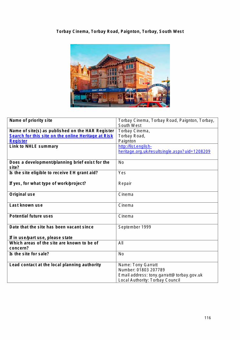
Torbay Cinema, Torbay Road, Paignton, Torbay, South West
Name of priority site Torbay Cinema, Torbay Road, Paignton, Torbay, South West
Name of site(s) as published on the HAR Register Search for this site on the online Heritage at Risk Register
Torbay Cinema, Torbay Road, Paignton
Link to NHLE summary http://list.englishheritage.org.uk/resultsingle.aspx?uid=1208209
Does a development/planning brief exist for the site?
No
Is the site eligible to receive EH grant aid?
If yes, for what type of work/project?
Yes
Repair
Original use Cinema
Last known use Cinema
Potential future uses Cinema
Date that the site has been vacant since
If in use/part use, please state
September 1999
Which areas of the site are known to be of concern?
All
Is the site for sale? No
Lead contact at the local planning authority Name: Tony Garratt Number: 01803 207789 Email address: [email protected] Local Authority: Torbay Council
116
West Midlands Heritage at Risk Priority Sites 2013
• Former Ditherington Flax Mill (including the attached former malt kiln, Apprentice House, Flax dressing building, and the Stove House and Dye House), Spring Gardens, Ditherington, Shrewsbury, West Midlands
• Grand Hotel, Colmore Row, Birmingham
• Longton Town Centre Conservation Area, Longton, Stoke-on-Trent
• Ludlow town walls, Ludlow, Shropshire
• Middleport Pottery, Middleport, Stoke-on-Trent
• Newman Brothers Coffin Furniture Works, 13-15 Fleet Street, Hockley, Birmingham
• Snailbeach New Smeltmill and Candle House, Snailbeach Lead Mine, Worthen with Shelve, Shropshire
• Snodhill Castle and scheduled area, Snodhill, Peterchurch, Herefordshire
• The Old Rectory, Lower Brailes, Stratford on Avon, Warwickshire
• Toll House, Clopton Bridge, Stratford on Avon, Warwickshire
117
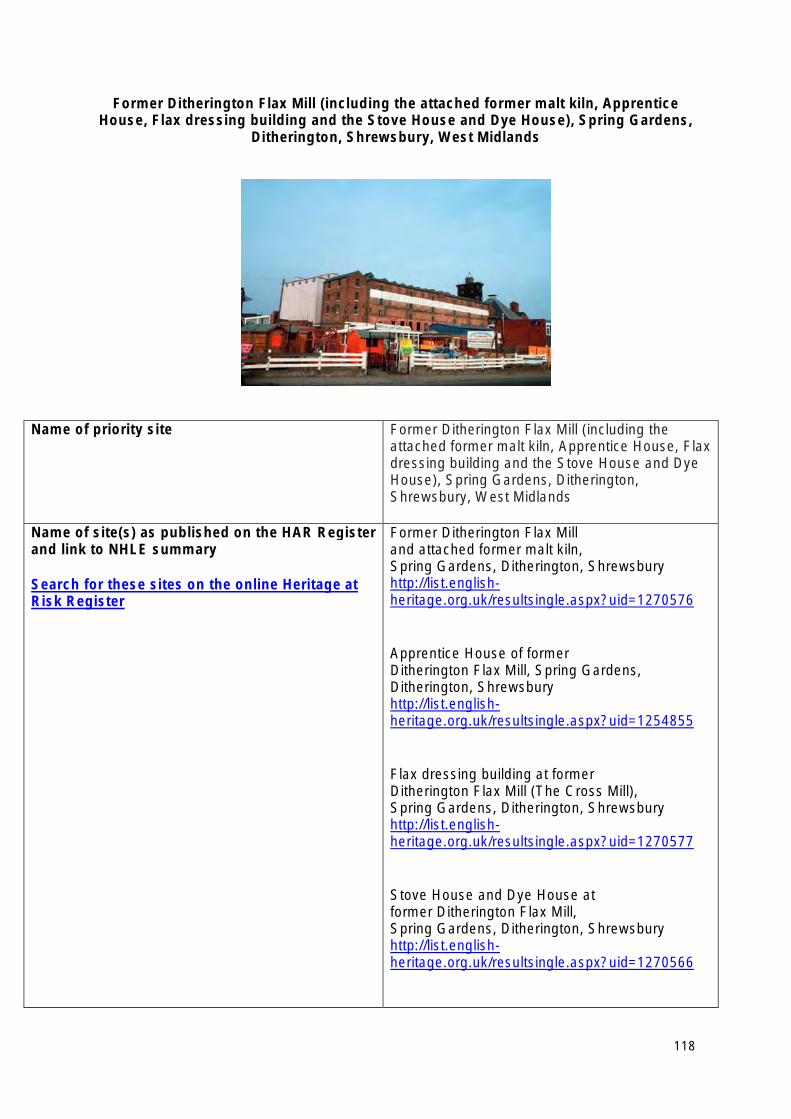
Former Ditherington Flax Mill (including the attached former malt kiln, Apprentice House, Flax dressing building and the Stove House and Dye House), Spring Gardens,
Ditherington, Shrewsbury, West Midlands
Name of priority site Former Ditherington Flax Mill (including the attached former malt kiln, Apprentice House, Flax dressing building and the Stove House and Dye House), Spring Gardens, Ditherington, Shrewsbury, West Midlands
Name of site(s) as published on the HAR Register and link to NHLE summary
Search for these sites on the online Heritage at Risk Register
Former Ditherington Flax Mill and attached former malt kiln, Spring Gardens, Ditherington, Shrewsbury http://list.englishheritage.org.uk/resultsingle.aspx?uid=1270576
Apprentice House of former Ditherington Flax Mill, Spring Gardens, Ditherington, Shrewsbury http://list.englishheritage.org.uk/resultsingle.aspx?uid=1254855
Flax dressing building at former Ditherington Flax Mill (The Cross Mill), Spring Gardens, Ditherington, Shrewsbury http://list.englishheritage.org.uk/resultsingle.aspx?uid=1270577
Stove House and Dye House at former Ditherington Flax Mill, Spring Gardens, Ditherington, Shrewsbury http://list.englishheritage.org.uk/resultsingle.aspx?uid=1270566
118
Does a development/planning brief exist for the site?
If yes, when was this produced
Outline planning consent for the heritage site (that owned by EH) together with adjacent land (part owned by EH part by Shropshire Council) was secured in November 2011.
Detailed Planning and Listed Building Consent was also secured in November 2011 for the Main Mill, Cross Mill, Kiln, and Warehouse.
Is the site eligible to receive EH grant aid?
If yes, for what type of work/project?
Yes
Structural and fabric repairs to all the buildings.
Original use 1797-1886 Flax Mill
Last known use 1897 to 1939 - Maltings 1939 to 1945 - Military Barracks 1987 - Maltings 1985 to present - redundant and empty 2005 - acquired by EH
Potential future uses • Community Arts/Heritage Project • Offices - commercial • Residential • Commercial • Local Authority offices
Date that the site have been vacant since 1985
Which areas of the site are known to be of concern?
All the buildings
Is the site for sale? No - English Heritage own freehold
Lead contact at the local planning authority Name: Elizabeth Perkins, Project Manager Number: 01743 252549 Email address: [email protected] Local Authority: Shropshire Council
119
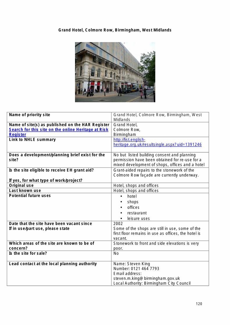
Grand Hotel, Colmore Row, Birmingham, West Midlands
Name of priority site Grand Hotel, Colmore Row, Birmingham, West Midlands
Name of site(s) as published on the HAR Register Search for this site on the online Heritage at Risk Register
Grand Hotel, Colmore Row, Birmingham
Link to NHLE summary http://list.englishheritage.org.uk/resultsingle.aspx?uid=1391246
Does a development/planning brief exist for the site?
No but listed building consent and planning permission have been obtained for re-use for a mixed development of shops, offices and a hotel
Is the site eligible to receive EH grant aid?
If yes, for what type of work/project?
Grant-aided repairs to the stonework of the Colmore Row façade are currently underway.
Original use Hotel, shops and offices Last known use Hotel, shops and offices Potential future uses • hotel
• shops • offices • restaurant • leisure uses
Date that the site have been vacant since If in use/part use, please state
2002 Some of the shops are still in use, some of the first floor remains in use as offices, the hotel is vacant.
Which areas of the site are known to be of concern?
Stonework to front and side elevations is very poor.
Is the site for sale? No
Lead contact at the local planning authority Name: Steven King Number: 0121 464 7793 Email address: [email protected] Local Authority: Birmingham City Council
120
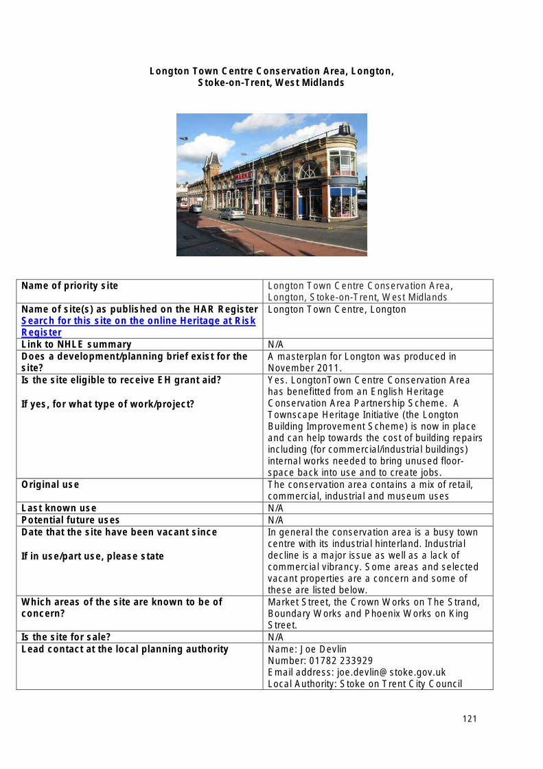
Longton Town Centre Conservation Area, Longton, Stoke-on-Trent, West Midlands
Name of priority site Longton Town Centre Conservation Area, Longton, Stoke-on-Trent, West Midlands
Name of site(s) as published on the HAR Register Search for this site on the online Heritage at Risk Register
Longton Town Centre, Longton
Link to NHLE summary N/A Does a development/planning brief exist for the site?
A masterplan for Longton was produced in November 2011.
Is the site eligible to receive EH grant aid?
If yes, for what type of work/project?
Yes. LongtonTown Centre Conservation Area has benefitted from an English Heritage Conservation Area Partnership Scheme. A Townscape Heritage Initiative (the Longton Building Improvement Scheme) is now in place and can help towards the cost of building repairs including (for commercial/industrial buildings) internal works needed to bring unused floor-space back into use and to create jobs.
Original use The conservation area contains a mix of retail, commercial, industrial and museum uses
Last known use N/A Potential future uses N/A Date that the site have been vacant since
If in use/part use, please state
In general the conservation area is a busy town centre with its industrial hinterland. Industrial decline is a major issue as well as a lack of commercial vibrancy. Some areas and selected vacant properties are a concern and some of these are listed below.
Which areas of the site are known to be of concern?
Market Street, the Crown Works on The Strand, Boundary Works and Phoenix Works on King Street.
Is the site for sale? N/A Lead contact at the local planning authority Name: Joe Devlin
Number: 01782 233929 Email address: [email protected] Local Authority: Stoke on Trent City Council
121
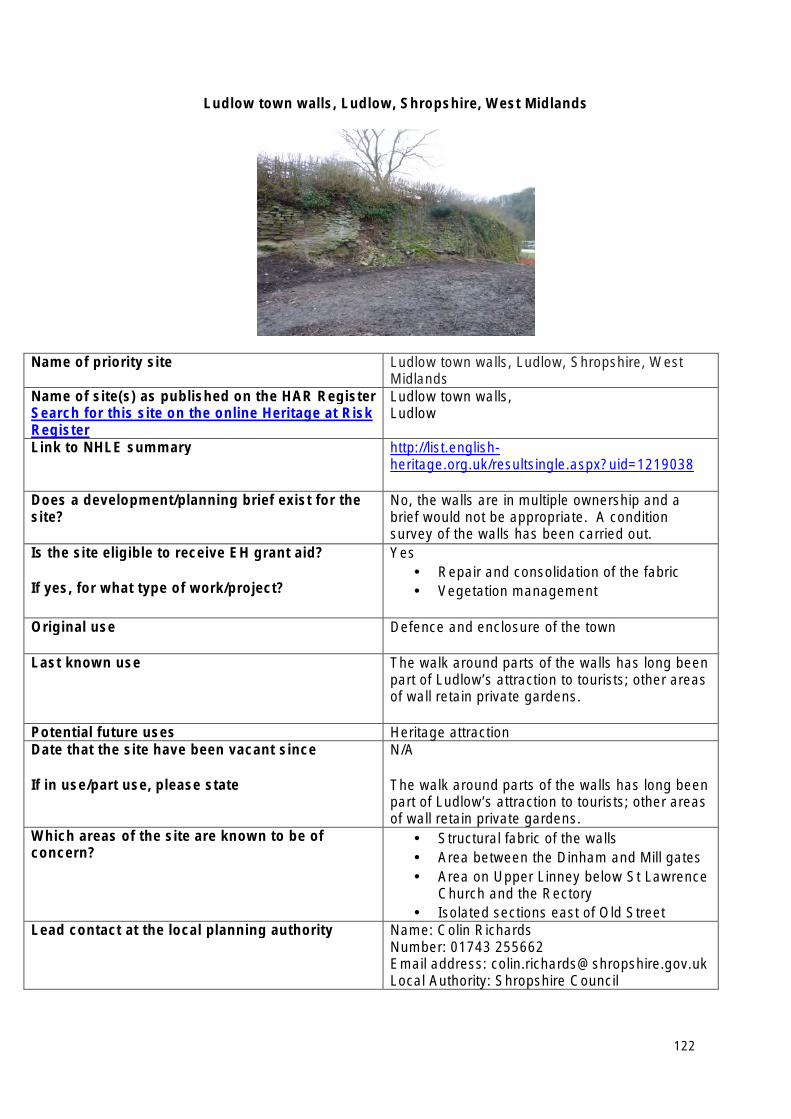
Ludlow town walls, Ludlow, Shropshire, West Midlands
Name of priority site Ludlow town walls, Ludlow, Shropshire, West Midlands
Name of site(s) as published on the HAR Register Search for this site on the online Heritage at Risk Register
Ludlow town walls, Ludlow
Link to NHLE summary http://list.englishheritage.org.uk/resultsingle.aspx?uid=1219038
Does a development/planning brief exist for the site?
No, the walls are in multiple ownership and a brief would not be appropriate. A condition survey of the walls has been carried out.
Is the site eligible to receive EH grant aid?
If yes, for what type of work/project?
Yes • Repair and consolidation of the fabric • Vegetation management
Original use Defence and enclosure of the town
Last known use The walk around parts of the walls has long been part of Ludlow’s attraction to tourists; other areas of wall retain private gardens.
Potential future uses Heritage attraction Date that the site have been vacant since
If in use/part use, please state
N/A
The walk around parts of the walls has long been part of Ludlow’s attraction to tourists; other areas of wall retain private gardens.
Which areas of the site are known to be of concern?
• Structural fabric of the walls • Area between the Dinham and Mill gates • Area on Upper Linney below St Lawrence
Church and the Rectory • Isolated sections east of Old Street
Lead contact at the local planning authority Name: Colin Richards Number: 01743 255662 Email address: [email protected] Local Authority: Shropshire Council
122
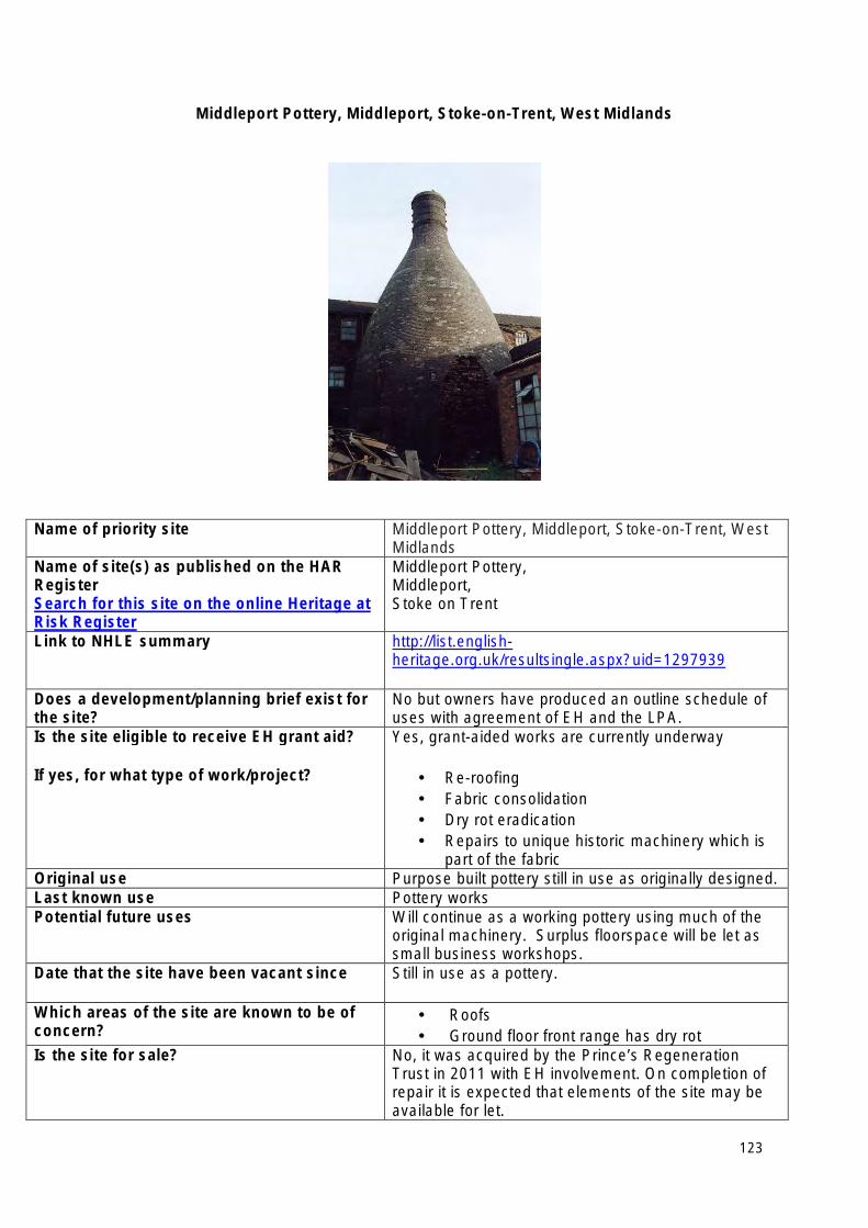
Middleport Pottery, Middleport, Stoke-on-Trent, West Midlands
Name of priority site Middleport Pottery, Middleport, Stoke-on-Trent, West Midlands
Name of site(s) as published on the HAR Register Search for this site on the online Heritage at Risk Register
Middleport Pottery, Middleport, Stoke on Trent
Link to NHLE summary http://list.englishheritage.org.uk/resultsingle.aspx?uid=1297939
Does a development/planning brief exist for the site?
No but owners have produced an outline schedule of uses with agreement of EH and the LPA.
Is the site eligible to receive EH grant aid?
If yes, for what type of work/project?
Yes, grant-aided works are currently underway
• Re-roofing • Fabric consolidation • Dry rot eradication • Repairs to unique historic machinery which is
part of the fabric Original use Purpose built pottery still in use as originally designed. Last known use Pottery works Potential future uses Will continue as a working pottery using much of the
original machinery. Surplus floorspace will be let as small business workshops.
Date that the site have been vacant since Still in use as a pottery.
Which areas of the site are known to be of concern?
• Roofs • Ground floor front range has dry rot
Is the site for sale? No, it was acquired by the Prince’s Regeneration Trust in 2011 with EH involvement. On completion of repair it is expected that elements of the site may be available for let.
123

Lead contact at the local planning authority Name: Jane Corfield Number: 01782 232154 Email address: [email protected] Local Authority: City of Stoke on Trent
124
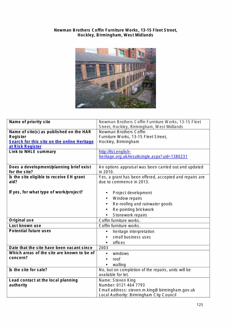
Newman Brothers Coffin Furniture Works, 13-15 Fleet Street, Hockley, Birmingham, West Midlands
Name of priority site Newman Brothers Coffin Furniture Works, 13-15 Fleet Street, Hockley, Birmingham, West Midlands
Name of site(s) as published on the HAR Register Search for this site on the online Heritage at Risk Register
Newman Brothers Coffin Furniture Works, 13-15 Fleet Street, Hockley, Birmingham
Link to NHLE summary http://list.englishheritage.org.uk/resultsingle.aspx?uid=1380231
Does a development/planning brief exist for the site?
An options appraisal was been carried out and updated in 2010.
Is the site eligible to receive EH grant aid?
If yes, for what type of work/project?
Yes, a grant has been offered, accepted and repairs are due to commence in 2013.
• Project development • Window repairs • Re-roofing and rainwater goods • Re-pointing brickwork • Stonework repairs
Original use Coffin furniture works. Last known use Coffin furniture works. Potential future uses • heritage interpretation
• small business uses • offices
Date that the site have been vacant since 2003 Which areas of the site are known to be of concern?
• windows • roof • walling
Is the site for sale? No, but on completion of the repairs, units will be available for let.
Lead contact at the local planning authority
Name: Steven King Number: 0121 464 7793 Email address: [email protected] Local Authority: Birmingham City Council
125
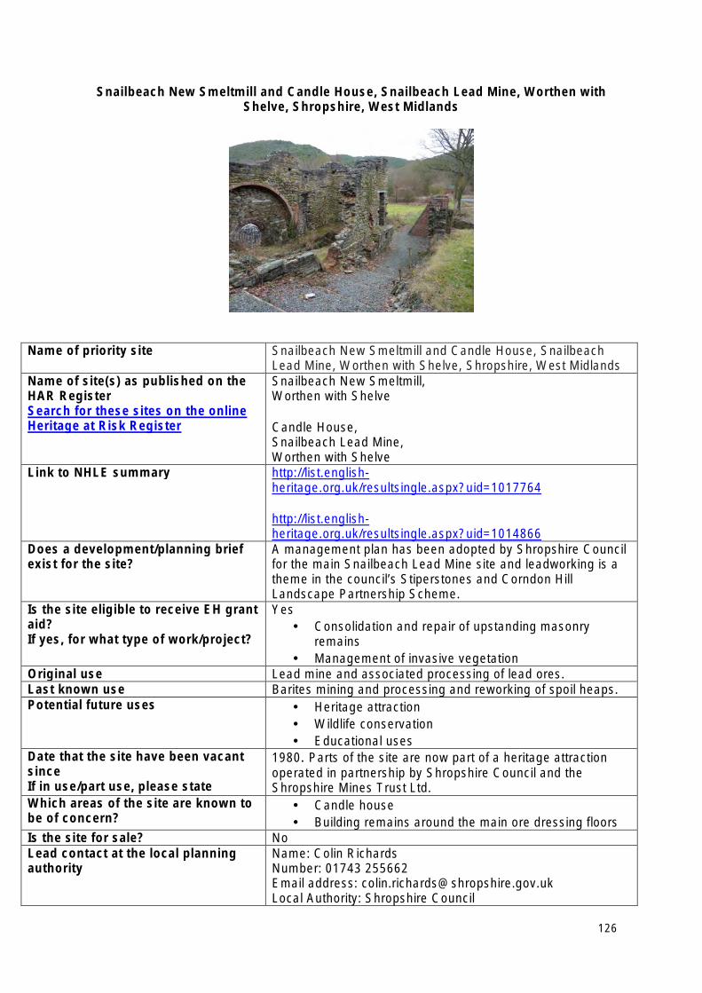
Snailbeach New Smeltmill and Candle House, Snailbeach Lead Mine, Worthen with Shelve, Shropshire, West Midlands
Name of priority site Snailbeach New Smeltmill and Candle House, Snailbeach Lead Mine, Worthen with Shelve, Shropshire, West Midlands
Name of site(s) as published on the HAR Register Search for these sites on the online Heritage at Risk Register
Snailbeach New Smeltmill, Worthen with Shelve
Candle House, Snailbeach Lead Mine, Worthen with Shelve
Link to NHLE summary http://list.englishheritage.org.uk/resultsingle.aspx?uid=1017764
http://list.englishheritage.org.uk/resultsingle.aspx?uid=1014866
Does a development/planning brief exist for the site?
A management plan has been adopted by Shropshire Council for the main Snailbeach Lead Mine site and leadworking is a theme in the council’s Stiperstones and Corndon Hill Landscape Partnership Scheme.
Is the site eligible to receive EH grant aid? If yes, for what type of work/project?
Yes • Consolidation and repair of upstanding masonry
remains • Management of invasive vegetation
Original use Lead mine and associated processing of lead ores. Last known use Barites mining and processing and reworking of spoil heaps. Potential future uses • Heritage attraction
• Wildlife conservation • Educational uses
Date that the site have been vacant since If in use/part use, please state
1980. Parts of the site are now part of a heritage attraction operated in partnership by Shropshire Council and the Shropshire Mines Trust Ltd.
Which areas of the site are known to be of concern?
• Candle house • Building remains around the main ore dressing floors
Is the site for sale? No Lead contact at the local planning authority
Name: Colin Richards Number: 01743 255662 Email address: [email protected] Local Authority: Shropshire Council
126
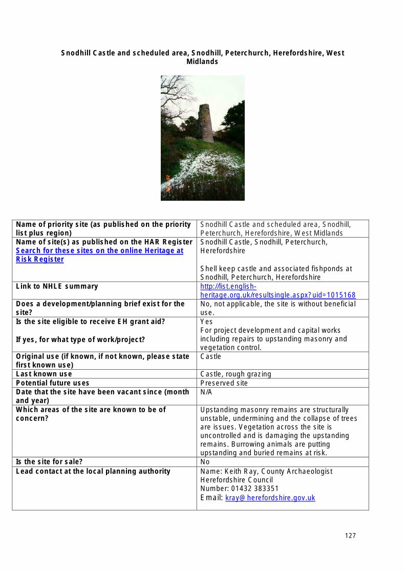
Snodhill Castle and scheduled area, Snodhill, Peterchurch, Herefordshire, West Midlands
Name of priority site (as published on the priority list plus region)
Snodhill Castle and scheduled area, Snodhill, Peterchurch, Herefordshire, West Midlands
Name of site(s) as published on the HAR Register Search for these sites on the online Heritage at Risk Register
Snodhill Castle, Snodhill, Peterchurch, Herefordshire
Shell keep castle and associated fishponds at Snodhill, Peterchurch, Herefordshire
Link to NHLE summary http://list.englishheritage.org.uk/resultsingle.aspx?uid=1015168
Does a development/planning brief exist for the site?
No, not applicable, the site is without beneficial use.
Is the site eligible to receive EH grant aid?
If yes, for what type of work/project?
Yes For project development and capital works including repairs to upstanding masonry and vegetation control.
Original use (if known, if not known, please state first known use)
Castle
Last known use Castle, rough grazing Potential future uses Preserved site Date that the site have been vacant since (month and year)
N/A
Which areas of the site are known to be of concern?
Upstanding masonry remains are structurally unstable, undermining and the collapse of trees are issues. Vegetation across the site is uncontrolled and is damaging the upstanding remains. Burrowing animals are putting upstanding and buried remains at risk.
Is the site for sale? No Lead contact at the local planning authority Name: Keith Ray, County Archaeologist
Herefordshire Council Number: 01432 383351 Email: [email protected]
127
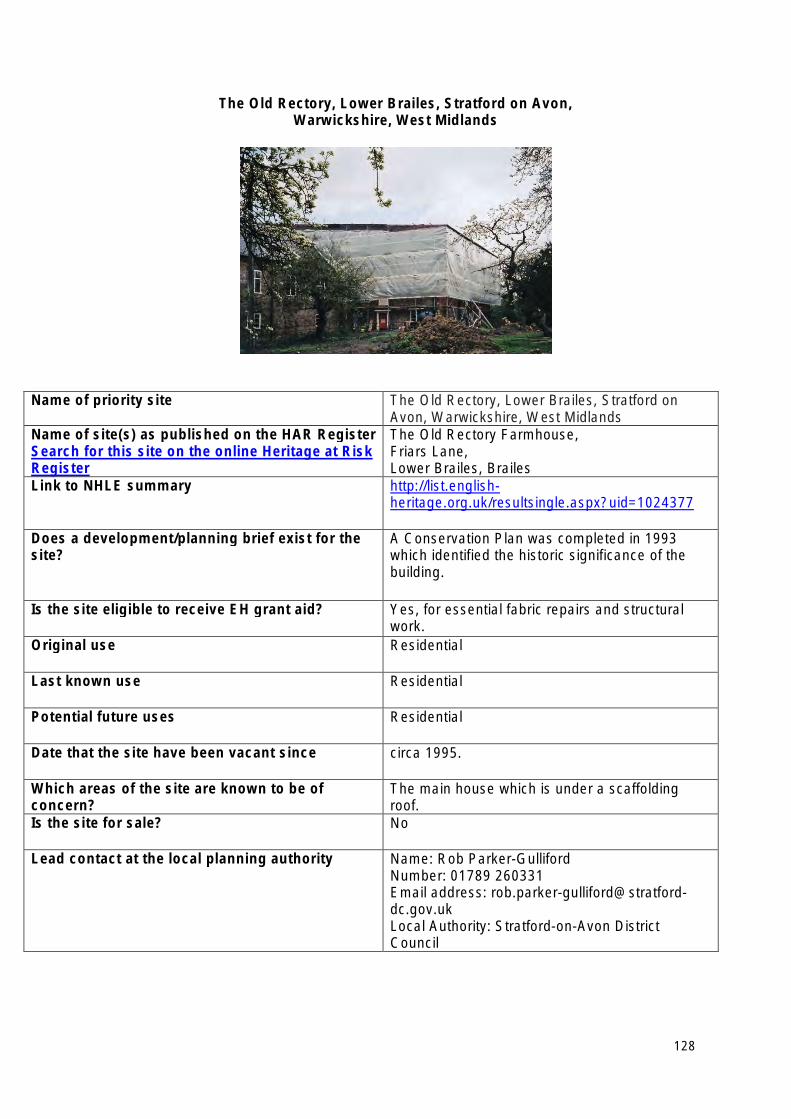
The Old Rectory, Lower Brailes, Stratford on Avon, Warwickshire, West Midlands
Name of priority site The Old Rectory, Lower Brailes, Stratford on Avon, Warwickshire, West Midlands
Name of site(s) as published on the HAR Register Search for this site on the online Heritage at Risk Register
The Old Rectory Farmhouse, Friars Lane, Lower Brailes, Brailes
Link to NHLE summary http://list.englishheritage.org.uk/resultsingle.aspx?uid=1024377
Does a development/planning brief exist for the site?
A Conservation Plan was completed in 1993 which identified the historic significance of the building.
Is the site eligible to receive EH grant aid? Yes, for essential fabric repairs and structural work.
Original use Residential
Last known use Residential
Potential future uses Residential
Date that the site have been vacant since circa 1995.
Which areas of the site are known to be of concern?
The main house which is under a scaffolding roof.
Is the site for sale? No
Lead contact at the local planning authority Name: Rob Parker-Gulliford Number: 01789 260331 Email address: rob.parker-gulliford@stratforddc.gov.uk Local Authority: Stratford-on-Avon District Council
128
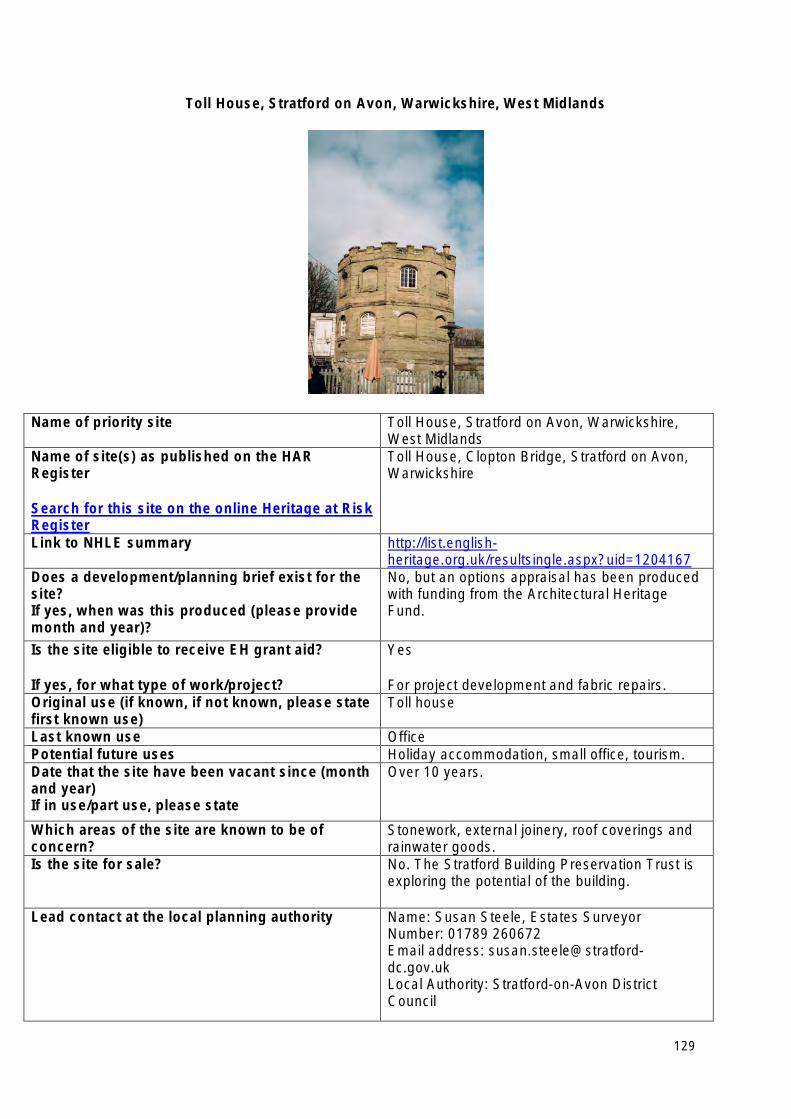
Toll House, Stratford on Avon, Warwickshire, West Midlands
Name of priority site Toll House, Stratford on Avon, Warwickshire, West Midlands
Name of site(s) as published on the HAR Register
Search for this site on the online Heritage at Risk Register
Toll House, Clopton Bridge, Stratford on Avon, Warwickshire
Link to NHLE summary http://list.englishheritage.org.uk/resultsingle.aspx?uid=1204167
Does a development/planning brief exist for the site? If yes, when was this produced (please provide month and year)?
No, but an options appraisal has been produced with funding from the Architectural Heritage Fund.
Is the site eligible to receive EH grant aid?
If yes, for what type of work/project?
Yes
For project development and fabric repairs. Original use (if known, if not known, please state first known use)
Toll house
Last known use Office Potential future uses Holiday accommodation, small office, tourism. Date that the site have been vacant since (month and year) If in use/part use, please state
Over 10 years.
Which areas of the site are known to be of concern?
Stonework, external joinery, roof coverings and rainwater goods.
Is the site for sale? No. The Stratford Building Preservation Trust is exploring the potential of the building.
Lead contact at the local planning authority Name: Susan Steele, Estates Surveyor Number: 01789 260672 Email address: susan.steele@stratforddc.gov.uk Local Authority: Stratford-on-Avon District Council
129
Yorkshire Heritage at Risk Priority Sites 2013
• Barden Church, Barden, Yorkshire Dales National Park
• Birdsall Estate (incl.16 scheduled monuments at risk), Birdsall Wold, Ryedale, North Yorkshire
• First Leeds White Cloth Hall, 98-101 (consec) Kirkgate, Leeds, West Yorkshire
• Grassington Moor (multi-period lead mines and processing works and 20th century barytes mill), Grassington, Yorkshire Dales National Park
• Keld Heads lead smeltmill and mine complex, Wensley, Richmondshire, North Yorkshire
• Kirklees Park Farm buildings (incl. Double aisled barn to north west of Kirklees Priory Gatehouse, Home Farm (Building No. 6), Kirklees Priory Gatehouse, L-shaped Aisled Barn, and the Malthouse) Brighouse, Calderdale, West Yorkshire
• Leah’s Yard, 20-22 Cambridge Street, Sheffield, South Yorkshire
• Rockley Blast Furnace and Engine House, Barnsley, South Yorkshire
• Whortlon Castle (gatehouse and ruins of undercroft), Castle Bank, Whorlton, North York Moors National Park
• Wressle Castle, Breighton Road, Wressle, East Riding of Yorkshire
130
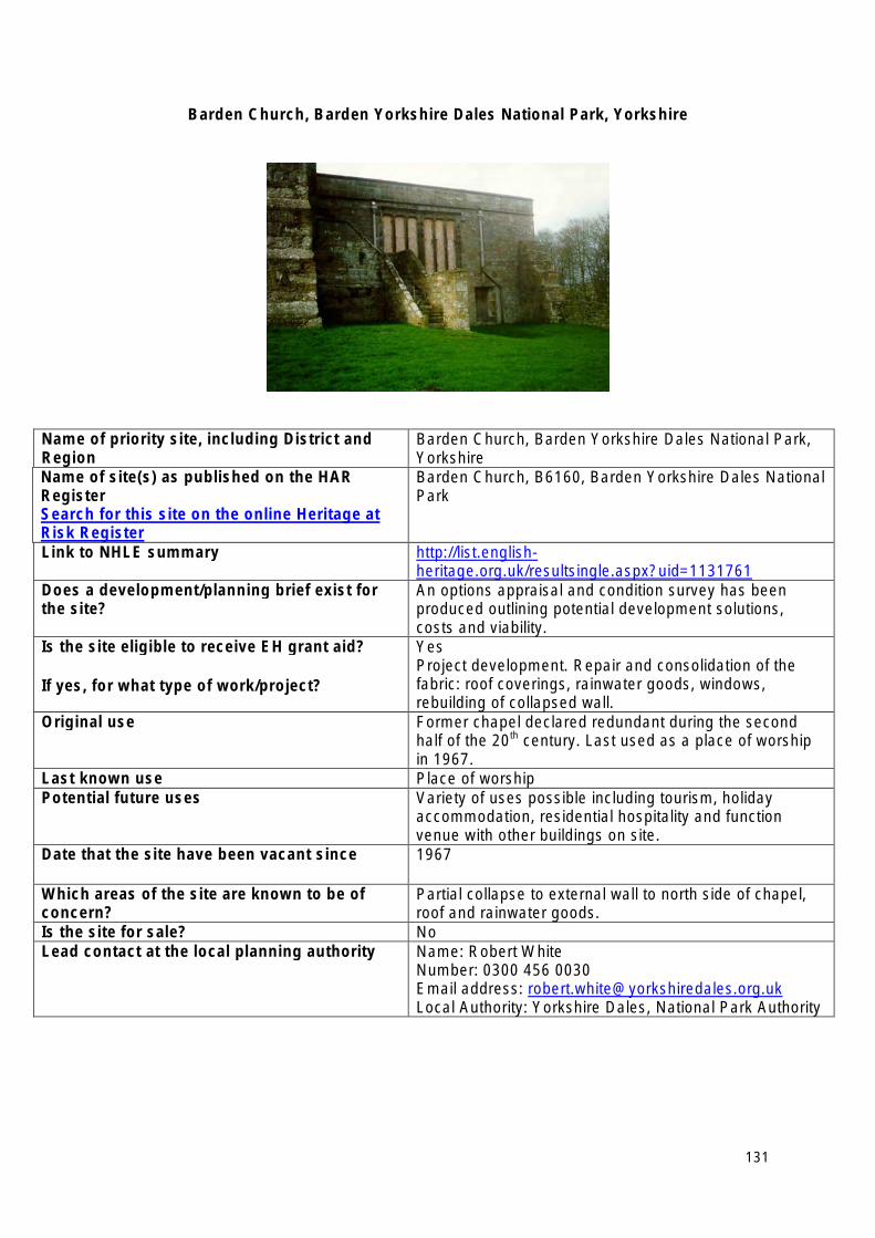
Barden Church, Barden Yorkshire Dales National Park, Yorkshire
Name of priority site, including District and Region
Barden Church, Barden Yorkshire Dales National Park, Yorkshire
Name of site(s) as published on the HAR Register Search for this site on the online Heritage at Risk Register
Barden Church, B6160, Barden Yorkshire Dales National Park
Link to NHLE summary http://list.englishheritage.org.uk/resultsingle.aspx?uid=1131761
Does a development/planning brief exist for the site?
An options appraisal and condition survey has been produced outlining potential development solutions, costs and viability.
Is the site eligible to receive EH grant aid?
If yes, for what type of work/project?
Yes Project development. Repair and consolidation of the fabric: roof coverings, rainwater goods, windows, rebuilding of collapsed wall.
Original use Former chapel declared redundant during the second half of the 20th century. Last used as a place of worship in 1967.
Last known use Place of worship Potential future uses Variety of uses possible including tourism, holiday
accommodation, residential hospitality and function venue with other buildings on site.
Date that the site have been vacant since 1967
Which areas of the site are known to be of concern?
Partial collapse to external wall to north side of chapel, roof and rainwater goods.
Is the site for sale? No Lead contact at the local planning authority Name: Robert White
Number: 0300 456 0030 Email address: [email protected] Local Authority: Yorkshire Dales, National Park Authority
131
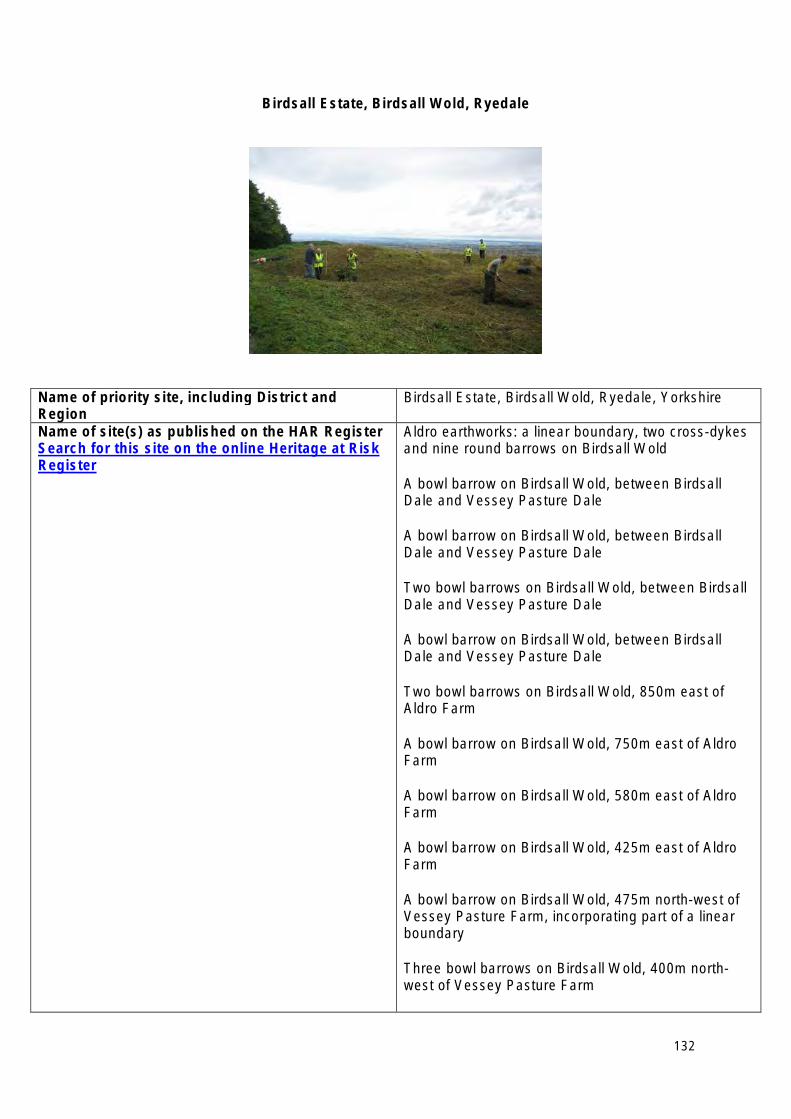
Birdsall Estate, Birdsall Wold, Ryedale
Name of priority site, including District and Region
Birdsall Estate, Birdsall Wold, Ryedale, Yorkshire
Name of site(s) as published on the HAR Register Search for this site on the online Heritage at Risk Register
Aldro earthworks: a linear boundary, two cross-dykes and nine round barrows on Birdsall Wold
A bowl barrow on Birdsall Wold, between Birdsall Dale and Vessey Pasture Dale
A bowl barrow on Birdsall Wold, between Birdsall Dale and Vessey Pasture Dale
Two bowl barrows on Birdsall Wold, between Birdsall Dale and Vessey Pasture Dale
A bowl barrow on Birdsall Wold, between Birdsall Dale and Vessey Pasture Dale
Two bowl barrows on Birdsall Wold, 850m east of Aldro Farm
A bowl barrow on Birdsall Wold, 750m east of Aldro Farm
A bowl barrow on Birdsall Wold, 580m east of Aldro Farm
A bowl barrow on Birdsall Wold, 425m east of Aldro Farm
A bowl barrow on Birdsall Wold, 475m north-west of Vessey Pasture Farm, incorporating part of a linear boundary
Three bowl barrows on Birdsall Wold, 400m northwest of Vessey Pasture Farm
132
A bowl barrow on Birdsall Wold, 250m north-west of Vessey Pasture Farm
A bowl barrow on Birdsall Wold, 300m north-east of Vessey Pasture Farm
A bowl barrow on Birdsall Wold, 250m south-east of Vessey Pasture Farm
Two round barrows 1/2 mile (800m) NE of Duggleby High Barn
Round barrows on Wharram Percy Wold Link to NHLE summary http://list.english
heritage.org.uk/resultsingle.aspx?uid=1007500 http://list.englishheritage.org.uk/resultsingle.aspx?uid=1007443 http://list.englishheritage.org.uk/resultsingle.aspx?uid=1007442 http://list.englishheritage.org.uk/resultsingle.aspx?uid=1007441 http://list.englishheritage.org.uk/resultsingle.aspx?uid=1007439 http://list.englishheritage.org.uk/resultsingle.aspx?uid=1007403 http://list.englishheritage.org.uk/resultsingle.aspx?uid=1007468 http://list.englishheritage.org.uk/resultsingle.aspx?uid=1007514 http://list.englishheritage.org.uk/resultsingle.aspx?uid=1007512 http://list.englishheritage.org.uk/resultsingle.aspx?uid=1007575 http://list.englishheritage.org.uk/resultsingle.aspx?uid=1007574 http://list.englishheritage.org.uk/resultsingle.aspx?uid=1007571 http://list.englishheritage.org.uk/resultsingle.aspx?uid=1007570 http://list.englishheritage.org.uk/resultsingle.aspx?uid=1007569 http://list.englishheritage.org.uk/resultsingle.aspx?uid=1004165 http://list.englishheritage.org.uk/resultsingle.aspx?uid=1004127
Does a development/planning brief exist for the site?
Discussions are underway with the owner to develop a management plan.
Is the site eligible to receive EH grant aid?
If yes, for what type of work/project?
Yes, for production of a management plan. Section 17 funding for Management Agreements where sites are not in stewardship.
Original use Prehistoric ritual sites Last known use Arable cultivation Potential future uses None Date that the site have been vacant since N\A
133

Which areas of the site are known to be of concern?
Threat to monuments through arable cultivation.
Is the site for sale? No Lead contact at the local planning authority Name: Gail Faulkener
Number: 08458 727374 Email address: [email protected] Local Authority: North Yorkshire County Council/Ryedale District Council
134
First White Cloth Hall, Leeds
Name of priority site, including District and Region
First White Cloth Hall, Leeds, Yorkshire
Name of site(s) as published on the HAR Register Search for this site on the online Heritage at Risk Register
First Leeds White Cloth Hall, 98-101 (consec.) Kirkgate, Leeds, West Yorkshire
Link to NHLE summary http://list.englishheritage.org.uk/resultsingle.aspx?uid=1375042
Does a development/planning brief exist for the site?
Yes
Is the site eligible to receive EH grant aid?
If yes, for what type of work/project?
Yes- project development and repair.
Original use Cloth Hall built for the trading of and storage of un-dyed cloth.
Last known use Retail Potential future uses Mixed commercial, retail, leisure. Date that the site have been vacant since 1990s Which areas of the site are known to be of concern?
Structural issues. One wing already subject to emergency demolition.
Is the site for sale? No Lead contact at the local planning authority Name: Phillip Ward
Number: 0113 247 8146 Email address: [email protected] Local Authority: Leeds
135
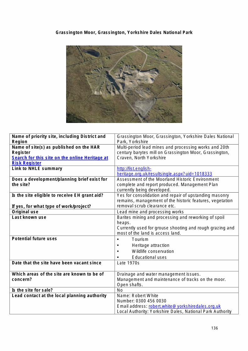
Grassington Moor, Grassington, Yorkshire Dales National Park
Name of priority site, including District and Region
Grassington Moor, Grassington, Yorkshire Dales National Park, Yorkshire
Name of site(s) as published on the HAR Register Search for this site on the online Heritage at Risk Register
Multi-period lead mines and processing works and 20th century barytes mill on Grassington Moor, Grassington, Craven, North Yorkshire
Link to NHLE summary http://list.englishheritage.org.uk/resultsingle.aspx?uid=1018333
Does a development/planning brief exist for the site?
Assessment of the Moorland Historic Environment complete and report produced. Management Plan currently being developed.
Is the site eligible to receive EH grant aid?
If yes, for what type of work/project?
Yes for consolidation and repair of upstanding masonry remains, management of the historic features, vegetation removal scrub clearance etc.
Original use Lead mine and processing works Last known use Barites mining and processing and reworking of spoil
heaps. Currently used for grouse shooting and rough grazing and most of the land is access land.
Potential future uses • Tourism • Heritage attraction • Wildlife conservation • Educational uses
Date that the site have been vacant since Late 1970s
Which areas of the site are known to be of concern?
Drainage and water management issues. Management and maintenance of tracks on the moor. Open shafts.
Is the site for sale? No Lead contact at the local planning authority Name: Robert White
Number: 0300 456 0030 Email address: [email protected] Local Authority: Yorkshire Dales, National Park Authority
136
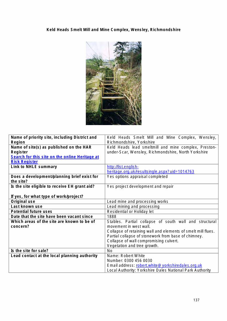
Keld Heads Smelt Mill and Mine Complex, Wensley, Richmondshire
Name of priority site, including District and Region
Keld Heads Smelt Mill and Mine Complex, Wensley, Richmondshire, Yorkshire
Name of site(s) as published on the HAR Register Search for this site on the online Heritage at Risk Register
Keld Heads lead smeltmill and mine complex, Prestonunder-Scar, Wensley, Richmondshire, North Yorkshire
Link to NHLE summary http://list.englishheritage.org.uk/resultsingle.aspx?uid=1014763
Does a development/planning brief exist for the site?
Yes options appraisal completed
Is the site eligible to receive EH grant aid?
If yes, for what type of work/project?
Yes project development and repair
Original use Lead mine and processing works Last known use Lead mining and processing Potential future uses Residential or Holiday let Date that the site have been vacant since 1888 Which areas of the site are known to be of concern?
Stables. Partial collapse of south wall and structural movement in west wall. Collapse of retaining wall and elements of smelt mill flues. Partial collapse of stonework from base of chimney. Collapse of wall compromising culvert. Vegetation and tree growth.
Is the site for sale? No Lead contact at the local planning authority Name: Robert White
Number: 0300 456 0030 Email address: [email protected] Local Authority: Yorkshire Dales National Park Authority
137
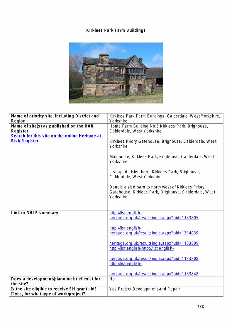
Kirklees Park Farm Buildings
Name of priority site, including District and Region
Kirklees Park Farm Buildings, Calderdale, West Yorkshire, Yorkshire
Name of site(s) as published on the HAR Register Search for this site on the online Heritage at Risk Register
Home Farm Building No.6 Kirklees Park, Brighouse, Calderdale, West Yorkshire
Kirklees Priory Gatehouse, Brighouse, Calderdale, West Yorkshire
Malthouse, Kirklees Park, Brighouse, Calderdale, West Yorkshire
L-shaped aisled barn, Kirklees Park, Brighouse, Calderdale, West Yorkshire
Double aisled barn to north west of Kirklees Priory Gatehouse, Kirklees Park, Brighouse, Calderdale, West Yorkshire
Link to NHLE summary http://list.englishheritage.org.uk/resultsingle.aspx?uid=1133805
http://list.englishheritage.org.uk/resultsingle.aspx?uid=1314039
heritage.org.uk/resultsingle.aspx?uid=1133809 http://list.english-http://list.english
heritage.org.uk/resultsingle.aspx?uid=1133808 http://list.english
heritage.org.uk/resultsingle.aspx?uid=1133848 Does a development/planning brief exist for the site?
No
Is the site eligible to receive EH grant aid? If yes, for what type of work/project?
Yes Project Development and Repair
138
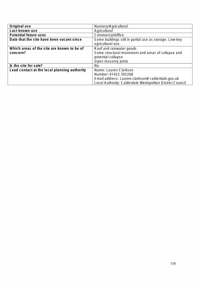
Original use Nunnery/Agricultural Last known use Agricultural Potential future uses Commercial/office Date that the site have been vacant since Some buildings still in partial use as storage. Low-key
agricultural use. Which areas of the site are known to be of concern?
Roof and rainwater goods Some structural movement and areas of collapse and potential collapse Open masonry joints
Is the site for sale? No Lead contact at the local planning authority Name: Lauren Clarkson
Number: 01422 392268 Email address: [email protected] Local Authority: Calderdale Metropolitan District Council
139
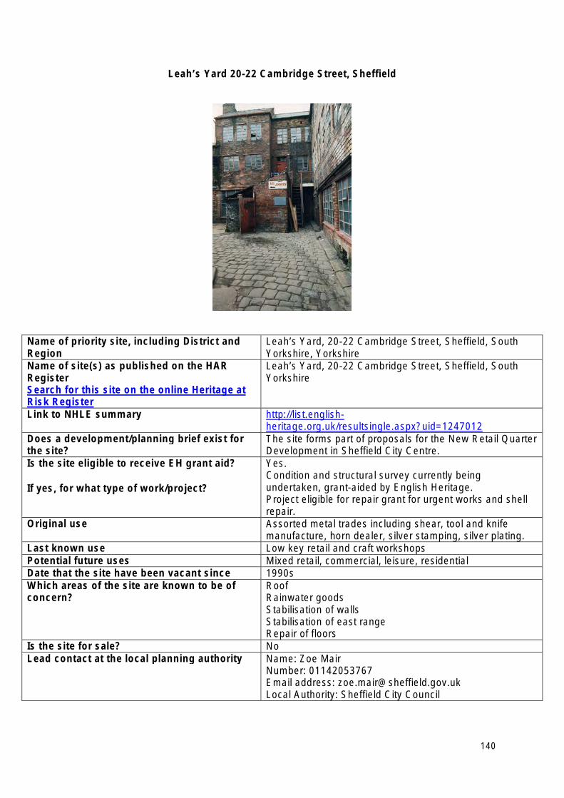
Leah’s Yard 20-22 Cambridge Street, Sheffield
Name of priority site, including District and Region
Leah’s Yard, 20-22 Cambridge Street, Sheffield, South Yorkshire, Yorkshire
Name of site(s) as published on the HAR Register Search for this site on the online Heritage at Risk Register
Leah’s Yard, 20-22 Cambridge Street, Sheffield, South Yorkshire
Link to NHLE summary http://list.englishheritage.org.uk/resultsingle.aspx?uid=1247012
Does a development/planning brief exist for the site?
The site forms part of proposals for the New Retail Quarter Development in Sheffield City Centre.
Is the site eligible to receive EH grant aid?
If yes, for what type of work/project?
Yes. Condition and structural survey currently being undertaken, grant-aided by English Heritage. Project eligible for repair grant for urgent works and shell repair.
Original use Assorted metal trades including shear, tool and knife manufacture, horn dealer, silver stamping, silver plating.
Last known use Low key retail and craft workshops Potential future uses Mixed retail, commercial, leisure, residential Date that the site have been vacant since 1990s Which areas of the site are known to be of concern?
Roof Rainwater goods Stabilisation of walls Stabilisation of east range Repair of floors
Is the site for sale? No Lead contact at the local planning authority Name: Zoe Mair
Number: 01142053767 Email address: [email protected] Local Authority: Sheffield City Council
140
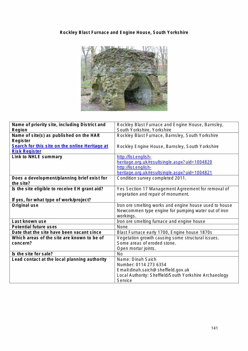
Rockley Blast Furnace and Engine House, South Yorkshire
Name of priority site, including District and Region
Rockley Blast Furnace and Engine House, Barnsley, South Yorkshire, Yorkshire
Name of site(s) as published on the HAR Register Search for this site on the online Heritage at Risk Register
Rockley Blast Furnace, Barnsley, South Yorkshire
Rockley Engine House, Barnsley, South Yorkshire
Link to NHLE summary http://list.englishheritage.org.uk/resultsingle.aspx?uid=1004820 http://list.englishheritage.org.uk/resultsingle.aspx?uid=1004821
Does a development/planning brief exist for the site?
Condition survey completed 2011.
Is the site eligible to receive EH grant aid?
If yes, for what type of work/project?
Yes Section 17 Management Agreement for removal of vegetation and repair of monument.
Original use Iron ore smelting works and engine house used to house Newcommen type engine for pumping water out of iron workings.
Last known use Iron ore smelting furnace and engine house Potential future uses None Date that the site have been vacant since Blast Furnace early 1700, Engine house 1870s Which areas of the site are known to be of concern?
Vegetation growth causing some structural issues. Some areas of eroded stone. Open mortar joints.
Is the site for sale? No Lead contact at the local planning authority Name: Dinah Saich
Number: 0114 273 6354 Email:[email protected] Local Authority: Sheffield/South Yorkshire Archaeology Service
141
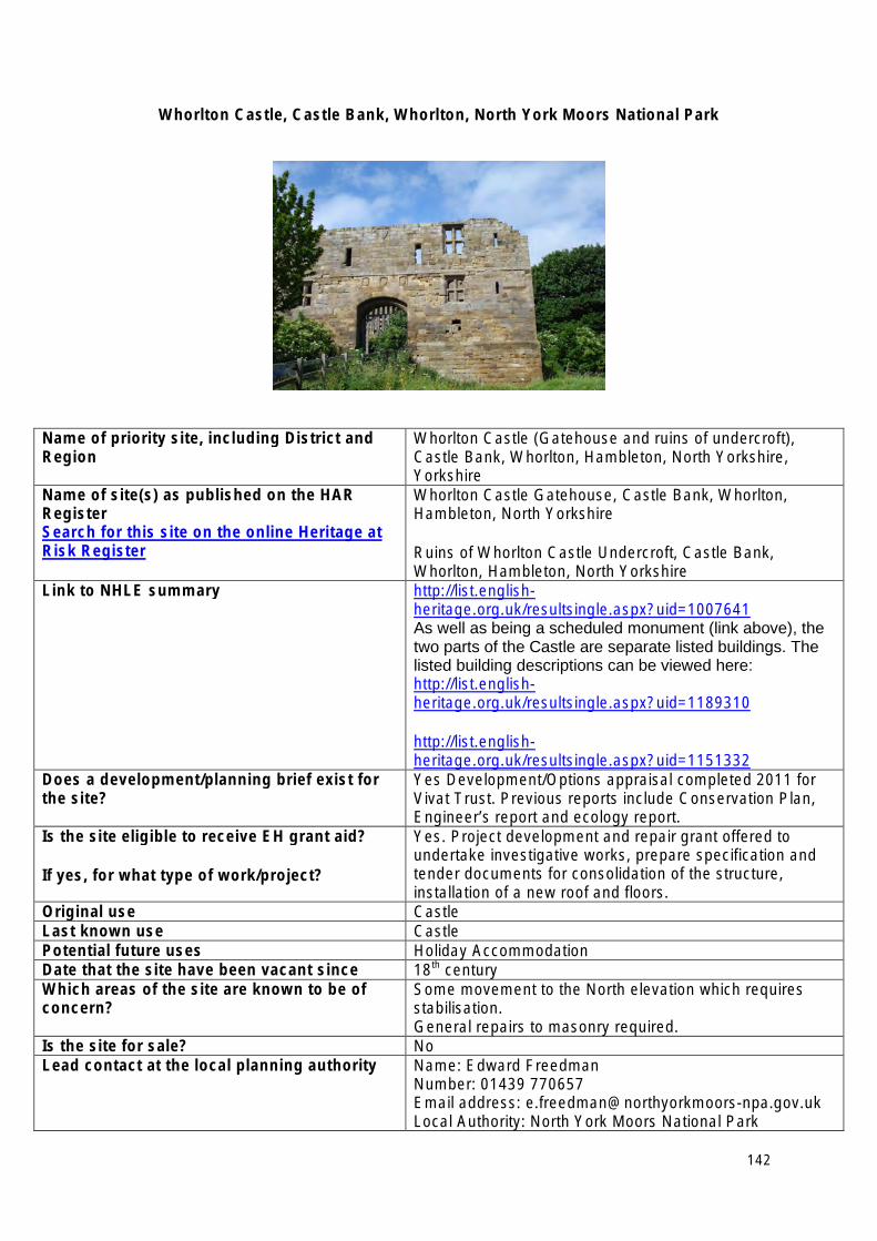
Whorlton Castle, Castle Bank, Whorlton, North York Moors National Park
Name of priority site, including District and Region
Whorlton Castle (Gatehouse and ruins of undercroft), Castle Bank, Whorlton, Hambleton, North Yorkshire, Yorkshire
Name of site(s) as published on the HAR Register Search for this site on the online Heritage at Risk Register
Whorlton Castle Gatehouse, Castle Bank, Whorlton, Hambleton, North Yorkshire
Ruins of Whorlton Castle Undercroft, Castle Bank, Whorlton, Hambleton, North Yorkshire
Link to NHLE summary http://list.englishheritage.org.uk/resultsingle.aspx?uid=1007641 As well as being a scheduled monument (link above), the two parts of the Castle are separate listed buildings. The listed building descriptions can be viewed here: http://list.englishheritage.org.uk/resultsingle.aspx?uid=1189310
http://list.englishheritage.org.uk/resultsingle.aspx?uid=1151332
Does a development/planning brief exist for the site?
Yes Development/Options appraisal completed 2011 for Vivat Trust. Previous reports include Conservation Plan, Engineer’s report and ecology report.
Is the site eligible to receive EH grant aid?
If yes, for what type of work/project?
Yes. Project development and repair grant offered to undertake investigative works, prepare specification and tender documents for consolidation of the structure, installation of a new roof and floors.
Original use Castle Last known use Castle Potential future uses Holiday Accommodation Date that the site have been vacant since 18th century Which areas of the site are known to be of concern?
Some movement to the North elevation which requires stabilisation. General repairs to masonry required.
Is the site for sale? No Lead contact at the local planning authority Name: Edward Freedman
Number: 01439 770657 Email address: [email protected] Local Authority: North York Moors National Park
142
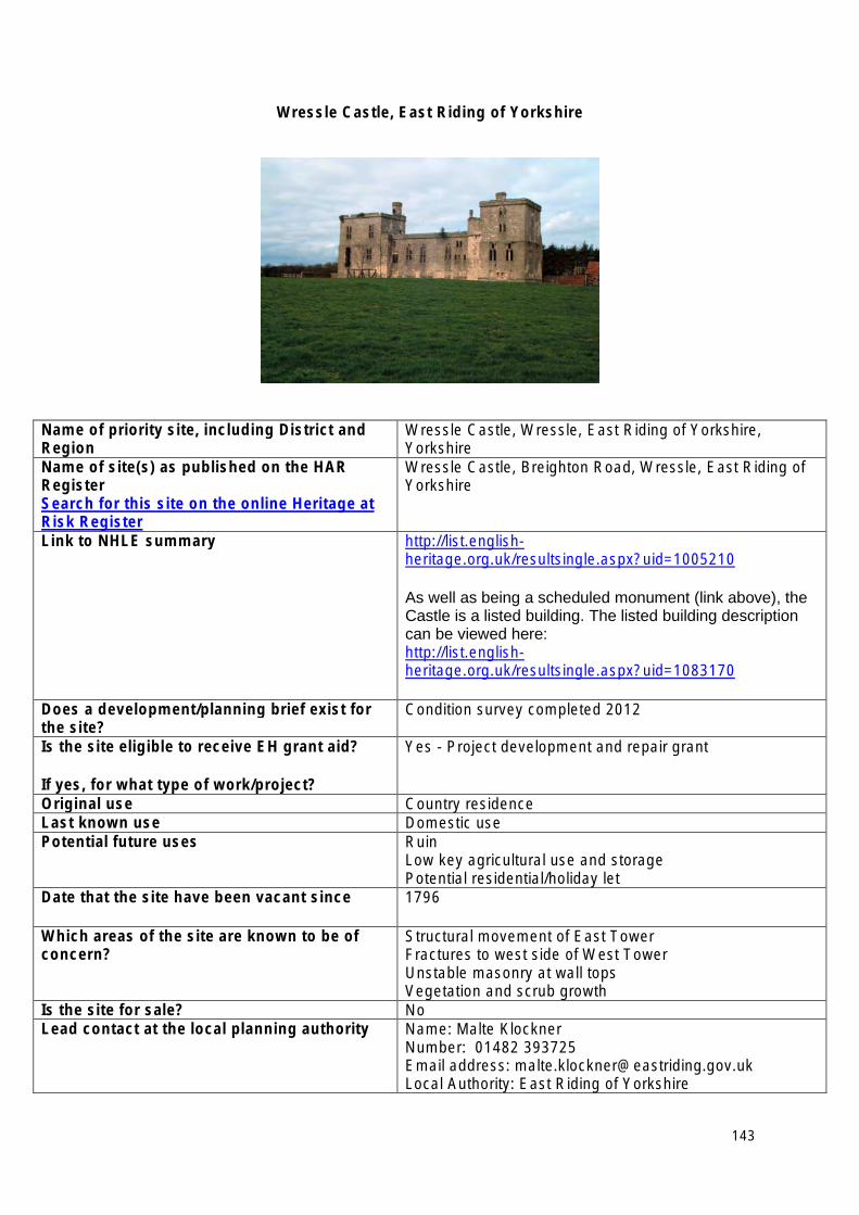
Wressle Castle, East Riding of Yorkshire
Name of priority site, including District and Region
Wressle Castle, Wressle, East Riding of Yorkshire, Yorkshire
Name of site(s) as published on the HAR Register Search for this site on the online Heritage at Risk Register
Wressle Castle, Breighton Road, Wressle, East Riding of Yorkshire
Link to NHLE summary http://list.englishheritage.org.uk/resultsingle.aspx?uid=1005210
As well as being a scheduled monument (link above), the Castle is a listed building. The listed building description can be viewed here: http://list.englishheritage.org.uk/resultsingle.aspx?uid=1083170
Does a development/planning brief exist for the site?
Condition survey completed 2012
Is the site eligible to receive EH grant aid?
If yes, for what type of work/project?
Yes - Project development and repair grant
Original use Country residence Last known use Domestic use Potential future uses Ruin
Low key agricultural use and storage Potential residential/holiday let
Date that the site have been vacant since 1796
Which areas of the site are known to be of concern?
Structural movement of East Tower Fractures to west side of West Tower Unstable masonry at wall tops Vegetation and scrub growth
Is the site for sale? No Lead contact at the local planning authority Name: Malte Klockner
Number: 01482 393725 Email address: [email protected] Local Authority: East Riding of Yorkshire
143

144

If you require an alternative accessible version of this document (for instance in audio, Braille or large print) please contact our Customer Services Department: Telephone: 0870 333 1181 Fax: 01793 414926 Textphone: 0800 015 0516 E-mail: [email protected]