Embed Size (px)
Citation preview
Mt Harper ice rinkBaseline inspection and historic values assessment
Katharine Watson
HERITAGE ASSESSMENT SERIES 2
Mt Harper ice rinkBaseline inspection and historic values assessment
Katharine Watson

Cover: Mt Harper ice rink with the Rangitata River in the background. Photo: Ian Hill, DOC.
The Heritage Assessment Series presents research funded by the New Zealand Department of Conservation (DOC). A heritage assessment is the key document used by DOC to identify the heritage values and significance of a place and, in turn, determine its management. Heritage assessments are prepared, and peer-reviewed, by heritage specialists. As they have been commissioned on an individual basis, there will be some variation in the structure of the reports that appear in the series.
This report is available from the departmental website in pdf form. Titles are listed in our catalogue on the website, refer www.doc.govt.nz under Publications, then Series
Unless otherwise stated, all images contained within this report remain the property of the owners and must not be reproduced in other material without their permission.
© Copyright July 2016, New Zealand Department of Conservation
ISSN 2463–6304 (web PDF)ISBN 978–0–478–15085–8 (web PDF)
This report was prepared for publication by the Publishing Team; editing by Amanda Todd and layout by Lynette Clelland. Publication was approved by the Director, Recreation, Tourism and Heritage Unit, Department of Conservation, Wellington, New Zealand.
Published by Publishing Team, Department of Conservation, PO Box 10420, The Terrace, Wellington 6143, New Zealand.
In the interest of forest conservation, we support paperless electronic publishing.
Peer review statement
Assessment prepared by Katharine Watson, Underground Overground Archaeology Ltd, 8/31 Stevens Street, Waltham, Christchurch 8011Date: 2014
Assessment reviewed by Neville Ritchie, Department of Conservation Date: 12/03/2014
CONTENTS
Abstract 1
1. Introduction 2
2. Methods 3
3. Setting 3
4. History 3
4.1 Wyndham Barker 3
4.2 Ownership 4
4.3 Establishment of the ice rink 5
4.4 Access to the rink 8
4.5 The ice 9
4.6 Buildings 10
4.7 Hydro power scheme 13
4.8 Skating at Mt Harper ice rink 13
4.9 Demise of the rink 14
5. Physical description 14
5.1 The original rink 14
5.2 Access to the rink 16
5.3 The later rink 16
5.4 Buildings 20
5.5 Hydro power scheme 32
5.6 Other features 35
6. Cultural connections 35
7. Contextual analysis 35
7.1 The 19th century 35
7.2 The 20th century 36
8. Assessment of significance 38
8.1 Historical significance 38
8.2 Physical significance 39
8.3 Cultural significance 39
9. Comparative analysis 39
10. Recommendations 40
11. References 41

1Heritage Assessment Series 2
Mt Harper ice rink
Baseline inspection and historic values assessment
Katharine Watson
Underground Overground Archaeology Ltd, 8/31 Stevens Street, Waltham, Christchurch 8011
AbstractThe Mt Harper ice rink in the Rangitata Gorge, Canterbury, was built as a private venture in 1931–32 and at the time was reputed to be the largest rink in the southern hemisphere. The rink relied on its very shaded location and hard frosts to build up ice during winter months. In its heyday it was a popular social amenity attracting hundreds of skaters and ice hockey players throughout the winter. It operated until the mid-1950s. It is now unused but, along with its remnant archaeology and buildings, is maintained as an Actively Conserved Historic Place by the Department of Conservation. This heritage assessment provides a summary of the rink’s history and a physical description of the site including photos and plans of the ponds, the water reticulation structures and the remaining buildings. It looks at the rink in the context of the history of winter sports in New Zealand and assesses its historical, cultural and physical significance. Although it was not the first rink to be constructed in New Zealand, it was the largest and possibly only commercial rink in the country at the time it was built. For the above reasons and its role in the development of ice hockey and skating in New Zealand and the comparative completeness of its physical remains it is considered nationally rare and of high national significance.
Key words: Ice rink, ice skating, winter sports, Mt Harper, Actively Conserved Historic Place, New Zealand
© Copyright July 2016, Department of Conservation. This paper may be cited as: Watson, K. 2016: Mt Harper ice rink: baseline inspection and historic values assessment. Heritage Assessment Series 2. Department of Conservation, Wellington. 42 p.
2 Watson—Mt Harper ice rink
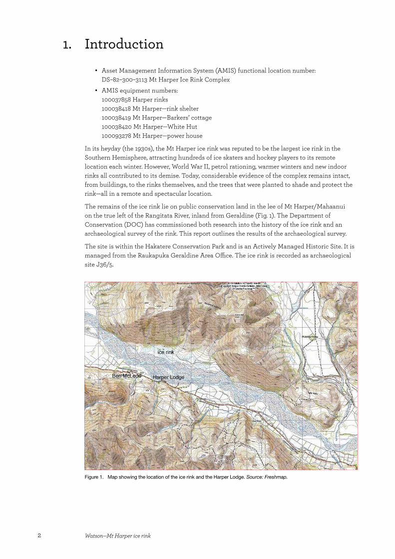
1. Introduction
• Asset Management Information System (AMIS) functional location number: DS–82–300–3113 Mt Harper Ice Rink Complex
• AMIS equipment numbers: 100037858 Harper rinks100038418 Mt Harper—rink shelter100038419 Mt Harper—Barkers’ cottage100038420 Mt Harper—White Hut100093278 Mt Harper—power house
In its heyday (the 1930s), the Mt Harper ice rink was reputed to be the largest ice rink in the Southern Hemisphere, attracting hundreds of ice skaters and hockey players to its remote location each winter. However, World War II, petrol rationing, warmer winters and new indoor rinks all contributed to its demise. Today, considerable evidence of the complex remains intact, from buildings, to the rinks themselves, and the trees that were planted to shade and protect the rink—all in a remote and spectacular location.
The remains of the ice rink lie on public conservation land in the lee of Mt Harper/Mahaanui on the true left of the Rangitata River, inland from Geraldine (Fig. 1). The Department of Conservation (DOC) has commissioned both research into the history of the ice rink and an archaeological survey of the rink. This report outlines the results of the archaeological survey.
The site is within the Hakatere Conservation Park and is an Actively Managed Historic Site. It is managed from the Raukapuka Geraldine Area Office. The ice rink is recorded as archaeological site J36/5.
Figure 1. Map showing the location of the ice rink and the Harper Lodge. Source: Freshmap.
3Heritage Assessment Series 2
2. Methods
The history of the ice rink outlined in this report has been drawn extensively from the research notes compiled by Gareth Wright and held by DOC.1 In the course of his research, Wright interviewed a number of people who had been associated with the rink, collected photographs and newspaper clippings relating to the rink, and consulted other relevant sources, including The Barkers of Aston, the Appendix to the Journals of the House of Representatives and files held at Archives New Zealand. Establishing precise information (particularly dates) from this material was not always easy, as there were conflicting dates and stories.
In addition, Papers Past (paperspast.natlib.govt.nz) was used to search 19th and early 20th century newspapers for information about the development of ice sports in New Zealand, and Richard (‘Richie’) Taylor, Bruce Allan and Graeme Glass were interviewed on 25 November 2009. Mr Taylor co-owned the rink for several years in the late 1940s and early 1950s; and Mr Allan’s father, Edgar, had a share in the rink at this time and the Allan family continued to use the rink into the early 1970s.
An archaeological survey of the rink was carried out in association with Michael Cradock (DOC) on 6–7 April 2009. During the survey, a sketch plan of the site was drawn. Coordinates for significant features were recorded using a hand-held Global Positioning System (GPS). However, there were some problems with this GPS and the data was lost. Therefore, the coordinates were re-recorded when the site was revisited by Ian Hill and Claire Baldwin (DOC) in January 2010.
3. Setting
As noted above, the Mt Harper ice rink is in the lee of Mt Harper/Mahaanui, on the true left of the Rangitata River (Fig. 1). It can be reached via a four-wheel-drive track from the Hakatere Potts Road, a distance of approximately 25 km, or via jet boat from the true right of the river. The rink is c. 56 km from Geraldine.
The rink is on a flat terrace at the base of Mt Harper/Mahaanui. Some of the ground in the surrounding area is swampy. Most of the vegetation is exotic and was planted in the 1930s, and there is some other low-growing scrub in the area.
4. History
4.1 Wyndham BarkerWyndham Barker (1886–1958) was the grandson of Dr A.C. Barker, a son of minor English gentry who arrived in Canterbury on the Charlotte Jane and the only doctor in Canterbury for a number of years (Turner 2007). Wyndham’s father, Arthur, had farms at Rangitata and Winchester (Barker 1932). Little is known of Wyndham’s life, but he was apparently educated in England and Europe, which appears to have been where he discovered ice skating (Kerr-North 1984).
1 Wright’s research brief was slightly broader than the brief for the archaeological survey and included the Harper Lodge. This lodge was built to provide accommodation for skaters and was located on the true right of the Rangitata River.
4 Watson—Mt Harper ice rink
Barker married a Dutch woman, Selly Bendieu, in 1910, with whom he had three children. These children were each born in different countries—Carel Herbert in Holland (1911), Isabel in Western Australia (1913) and Helen in California (1917)—indicating that the family moved around a great deal (Barker 1932). While in Holland, Barker is reputed to have ice skated the length of the country (Kerr-North 1984).
Barker married for a second time in 1931, to Brenda Lillie (Kerr-North 1984). What happened to his first wife is not recorded. It is also unknown when Barker returned to New Zealand, but he appears to have done so with the idea of establishing an ice rink, and examined a number of potential sites in Canterbury before settling on Mt Harper/Mahaanui (Kerr-North 1984; R. Taylor, pers. comm.).
At some stage, Wyndham and his brothers (Herbert and a third brother) took up the Ben McLeod run, which lies on the true right of the Rangitata River, roughly opposite the ice rink (Fig. 1). This seems to have happened before Barker started work on the rink, as Gwen Allan recalled that her late husband (Lloyd Allan) had worked for the Barkers at Ben McLeod and helped build the rink (Wright 2007).
What little information is available about Wyndham Barker suggests he was an eccentric man driven by a powerful vision. While ice skating was not unknown in Canterbury when he established the Mt Harper ice rink, research suggests that skaters in the late 1920s and early 1930s were mostly high country residents with access to the private rinks on a number of high country stations, or rinks associated with ski fields. Mt Harper was a public rink and thus (theoretically at least) open to all. It was also Barker’s drive and passion that led to the establishment of the Erewhon Cup, an ice hockey cup that is still contested today (Wright 2007).
There are some suggestions that Barker intended the rink to be a year-round club, with ice skating in the winter and tennis in the summer (Wright 2007). Certainly, Wyndham and Brenda lived at the rink year-round, with a Jersey cow (‘Sissy’) to provide them with milk and a garden to supply fresh vegetables (Kerr-North 1984). It was not until the late 1940s that the road to the ice rink (on the true left of the Rangitata River) was put in. Prior to this, access to the rink outside the skating season was by boat (from the true right of the river). One account has it that Sissy the cow was towed across the river behind this boat (Wright 2007), while another indicates that Barker walked Sissy from Winchester to the ice rink, following a pack track along the north bank of the Rangitata (Kerr-North 1984).
The Barkers left Mt Harper/Mahaanui (for Governors Bay) in 1946, by which time Barker was 60. Barker seems to have retained an interest in the rink, however, for his name appears in the visitors’ book at the time that the Kirkpatricks were installing the refrigeration unit (MHVB 1934–1954).
4.2 OwnershipThe land on which Wyndham Barker built the Mt Harper ice rink was leased from Mt Possession Station, with the rent paid to the University of Canterbury. The lease documents still exist and are held by the Allan family (Wright 2007). When the Barkers left Mt Harper/Mahaanui in 1946, they gave the rink to the people of Canterbury. The Department of Internal Affairs and the South Canterbury Council of Sport arranged matters, and the rink was run by the Mt Harper Ice Skating Club, which was established in 1946 (Kerr-North 1984; Wright 2007). In 1948, George Kirkpatrick and his brother (who did not have much involvement in the rink) took over the rink, but appear to have sold the lease in 1949, following the failure of their refrigeration plant.
In 1948, the Mt Harper Ice Skating Club paid Wyndham Barker £410 for ‘equipment left at the rink’ (Wright 2007). Why this should be necessary if Barker had gifted the rink is not clear. However, it may be that the club purchased the rink to then enable them to sell it to the Kirkpatricks who, in the face of increasingly poor ice, would be able to invest in the refrigeration equipment necessary to expand the rink’s life.
5Heritage Assessment Series 2
Richie Taylor, his brother Innes and Edgar Allan purchased the lease and the rink from the Kirkpatricks in 1949. The Taylors subsequently sold their share in the lease to Edgar. By the winter of 1955, the rink had closed (Wright 2007).
4.3 Establishment of the ice rinkWork on the first rink at Mt Harper/Mahaanui began in the summer of 1931/32, with staff from Ben McLeod and the adjacent Rata Peaks run helping Wyndham Barker. The site Barker had chosen was on a river flat in the lee of Mt Harper/Mahaanui, and was reached by crossing the river (by boat) and then crossing the swampy flats. The swampy ground was such that a causeway had to be built across it before a horse could be brought in. Work on the first building at the site—a house for Wyndham and Brenda Barker—started before the causeway was complete. Consequently, the materials for the house had to be packed into the site (after being taken across the river in the boat; Kerr-North 1984; Timaru Herald 1934). The horse in question was Barney, who was borrowed from Rata Peaks Station and was swum across the river, towing the boat (Kerr-North 1984).
The ground for the first rink was prepared by ploughing and working the area to level it. Sod walls were built to contain the water, and the causeway across the swampy flats connected with one of these walls, ensuring that skaters would not get wet feet crossing the icy swamps (assuming they had managed to keep their feet dry while crossing the river; R. Taylor, pers. comm.).
The first rink, however, was not a success. It was located c. 300 m from the slopes of Mt Harper/Mahaanui and was exposed to nor’west winds coming down the river. These winds rippled the ice, making it difficult to skate on (Wright 2007). Not to be deterred, Barker set about building another rink. The new site was in the same general area, but on a higher river terrace and closer to the slopes of Mt Harper/Mahaanui. There was a natural hollow in this area and Barker built a 4 ft (1.2 m) high sod wall along the edge of the hollow (MHVB 1934–1954), with the terrace face forming part of the walls of the rink. Using this natural feature meant that a larger area could be enclosed in this second rink than had been enclosed in the first for the same amount of work. Given this natural advantage, one wonders why Barker did not select the second area first, particularly given his apparent knowledge of ice skating and the effort he put into selecting a site. It may have been related to water supply or Barker may have been—justifiably—concerned about the swampy ground and the presence of a spring in the second area.
The second rink was being skated on by June 1933, indicating that construction of this rink had taken place in the intervening 12 months (Kerr-North 1984). However, newspaper reports suggest that the winter of 1934 was the first major public season (MHVB 1934–1954; Wright 2007). Therefore, Barker may have used 1933 as something of a trial season (particularly after the failure of his first rink the previous winter), or it may have been that he planned to improve the facilities—such as access and shelter, and providing skates for hire—between the winters of 1933 and 1934, in order to ensure the skaters had a good experience.
The nature of the facilities that were available and the layout of the rinks in the winter of 1934 are not known, as no photographs of the rink in that season have been found. However, one newspaper article from that winter was pasted into the Mt Harper visitors’ book, which explained that in this winter, the rink was reached via a punt (known as ‘Erewhon’) over the main branch of the river and a cradle over the second branch. There is no mention in the article of the layout or number of rinks, but there was evidently a hut at the rinks that could serve meals to up to 20 people and could also be used as a dressing room (Timaru Herald 1934). It is not known whether this was part of the Barkers’ house or the building later known as the skate shed.
Sir William Nosworthy, who owned Mesopotamia Station at the time, is reputed to have officially opened the ice rink (R. Taylor, pers. comm.).
6 Watson—Mt Harper ice rink
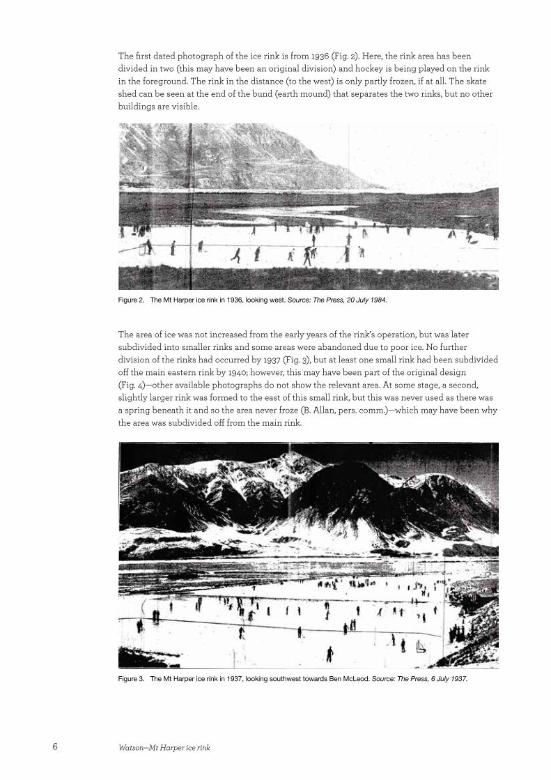
The first dated photograph of the ice rink is from 1936 (Fig. 2). Here, the rink area has been divided in two (this may have been an original division) and hockey is being played on the rink in the foreground. The rink in the distance (to the west) is only partly frozen, if at all. The skate shed can be seen at the end of the bund (earth mound) that separates the two rinks, but no other buildings are visible.
Figure 2. The Mt Harper ice rink in 1936, looking west. Source: The Press, 20 July 1984.
The area of ice was not increased from the early years of the rink’s operation, but was later subdivided into smaller rinks and some areas were abandoned due to poor ice. No further division of the rinks had occurred by 1937 (Fig. 3), but at least one small rink had been subdivided off the main eastern rink by 1940; however, this may have been part of the original design (Fig. 4)—other available photographs do not show the relevant area. At some stage, a second, slightly larger rink was formed to the east of this small rink, but this was never used as there was a spring beneath it and so the area never froze (B. Allan, pers. comm.)—which may have been why the area was subdivided off from the main rink.
Figure 3. The Mt Harper ice rink in 1937, looking southwest towards Ben McLeod. Source: The Press, 6 July 1937.
7Heritage Assessment Series 2
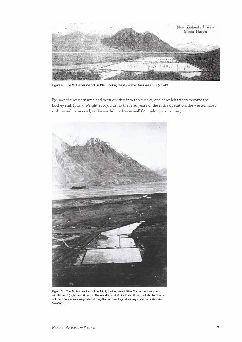
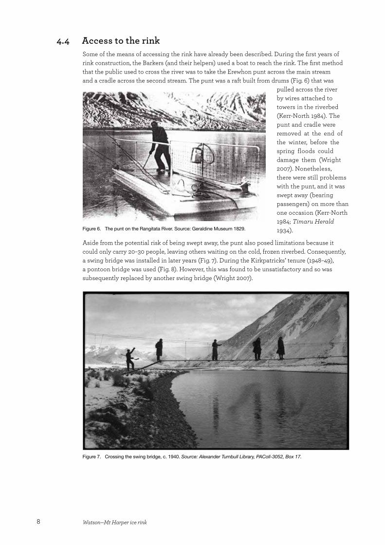
By 1947, the western area had been divided into three rinks, one of which was to become the hockey rink (Fig. 5; Wright 2007). During the later years of the rink’s operation, the westernmost rink ceased to be used, as the ice did not freeze well (R. Taylor, pers. comm.).
Figure 4. The Mt Harper ice rink in 1940, looking west. Source: The Press, 2 July 1940.
Figure 5. The Mt Harper ice rink in 1947, looking west. Rink 2 is in the foreground, with Rinks 5 (right) and 6 (left) in the middle, and Rinks 7 and 8 beyond. (Note: These rink numbers were designated during the archaeological survey.) Source: Ashburton Museum.
8 Watson—Mt Harper ice rink
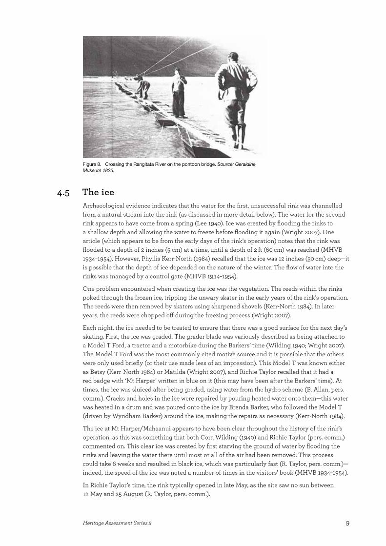
4.4 Access to the rinkSome of the means of accessing the rink have already been described. During the first years of rink construction, the Barkers (and their helpers) used a boat to reach the rink. The first method that the public used to cross the river was to take the Erewhon punt across the main stream and a cradle across the second stream. The punt was a raft built from drums (Fig. 6) that was
pulled across the river by wires attached to towers in the riverbed (Kerr-North 1984). The punt and cradle were removed at the end of the winter, before the spring floods could damage them (Wright 2007). Nonetheless, there were still problems with the punt, and it was swept away (bearing passengers) on more than one occasion (Kerr-North 1984; Timaru Herald 1934).
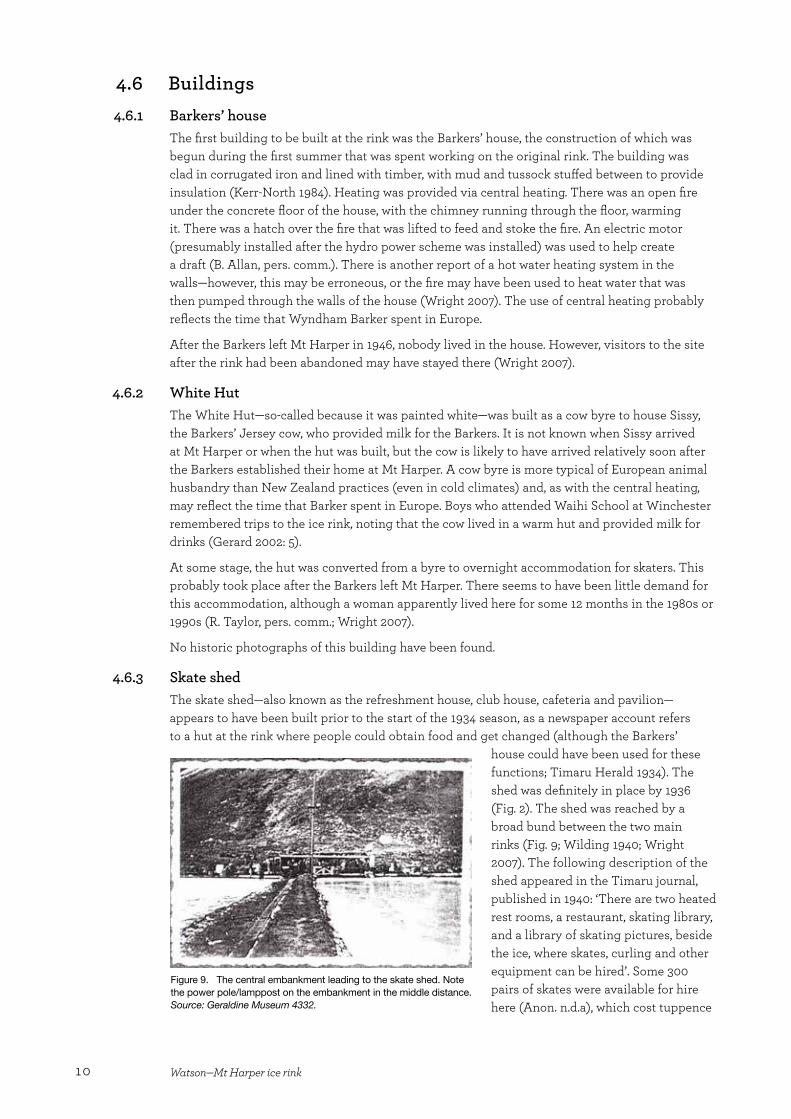
Aside from the potential risk of being swept away, the punt also posed limitations because it could only carry 20–30 people, leaving others waiting on the cold, frozen riverbed. Consequently, a swing bridge was installed in later years (Fig. 7). During the Kirkpatricks’ tenure (1948–49), a pontoon bridge was used (Fig. 8). However, this was found to be unsatisfactory and so was subsequently replaced by another swing bridge (Wright 2007).
Figure 6. The punt on the Rangitata River. Source: Geraldine Museum 1829.
Figure 7. Crossing the swing bridge, c. 1940. Source: Alexander Turnbull Library, PAColl-3052, Box 17.
9Heritage Assessment Series 2
4.5 The iceArchaeological evidence indicates that the water for the first, unsuccessful rink was channelled from a natural stream into the rink (as discussed in more detail below). The water for the second rink appears to have come from a spring (Lee 1940). Ice was created by flooding the rinks to a shallow depth and allowing the water to freeze before flooding it again (Wright 2007). One article (which appears to be from the early days of the rink’s operation) notes that the rink was flooded to a depth of 2 inches (5 cm) at a time, until a depth of 2 ft (60 cm) was reached (MHVB 1934–1954). However, Phyllis Kerr-North (1984) recalled that the ice was 12 inches (30 cm) deep—it is possible that the depth of ice depended on the nature of the winter. The flow of water into the rinks was managed by a control gate (MHVB 1934–1954).
One problem encountered when creating the ice was the vegetation. The reeds within the rinks poked through the frozen ice, tripping the unwary skater in the early years of the rink’s operation. The reeds were then removed by skaters using sharpened shovels (Kerr-North 1984). In later years, the reeds were chopped off during the freezing process (Wright 2007).
Each night, the ice needed to be treated to ensure that there was a good surface for the next day’s skating. First, the ice was graded. The grader blade was variously described as being attached to a Model T Ford, a tractor and a motorbike during the Barkers’ time (Wilding 1940; Wright 2007). The Model T Ford was the most commonly cited motive source and it is possible that the others were only used briefly (or their use made less of an impression). This Model T was known either as Betsy (Kerr-North 1984) or Matilda (Wright 2007), and Richie Taylor recalled that it had a red badge with ‘Mt Harper’ written in blue on it (this may have been after the Barkers’ time). At times, the ice was sluiced after being graded, using water from the hydro scheme (B. Allan, pers. comm.). Cracks and holes in the ice were repaired by pouring heated water onto them—this water was heated in a drum and was poured onto the ice by Brenda Barker, who followed the Model T (driven by Wyndham Barker) around the ice, making the repairs as necessary (Kerr-North 1984).
The ice at Mt Harper/Mahaanui appears to have been clear throughout the history of the rink’s operation, as this was something that both Cora Wilding (1940) and Richie Taylor (pers. comm.) commented on. This clear ice was created by first starving the ground of water by flooding the rinks and leaving the water there until most or all of the air had been removed. This process could take 6 weeks and resulted in black ice, which was particularly fast (R. Taylor, pers. comm.)—indeed, the speed of the ice was noted a number of times in the visitors’ book (MHVB 1934–1954).
In Richie Taylor’s time, the rink typically opened in late May, as the site saw no sun between 12 May and 25 August (R. Taylor, pers. comm.).
Figure 8. Crossing the Rangitata River on the pontoon bridge. Source: Geraldine Museum 1825.
10 Watson—Mt Harper ice rink
4.6 Buildings 4.6.1 Barkers’ house
The first building to be built at the rink was the Barkers’ house, the construction of which was begun during the first summer that was spent working on the original rink. The building was clad in corrugated iron and lined with timber, with mud and tussock stuffed between to provide insulation (Kerr-North 1984). Heating was provided via central heating. There was an open fire under the concrete floor of the house, with the chimney running through the floor, warming it. There was a hatch over the fire that was lifted to feed and stoke the fire. An electric motor (presumably installed after the hydro power scheme was installed) was used to help create a draft (B. Allan, pers. comm.). There is another report of a hot water heating system in the walls—however, this may be erroneous, or the fire may have been used to heat water that was then pumped through the walls of the house (Wright 2007). The use of central heating probably reflects the time that Wyndham Barker spent in Europe.
After the Barkers left Mt Harper in 1946, nobody lived in the house. However, visitors to the site after the rink had been abandoned may have stayed there (Wright 2007).
4.6.2 White HutThe White Hut—so-called because it was painted white—was built as a cow byre to house Sissy, the Barkers’ Jersey cow, who provided milk for the Barkers. It is not known when Sissy arrived at Mt Harper or when the hut was built, but the cow is likely to have arrived relatively soon after the Barkers established their home at Mt Harper. A cow byre is more typical of European animal husbandry than New Zealand practices (even in cold climates) and, as with the central heating, may reflect the time that Barker spent in Europe. Boys who attended Waihi School at Winchester remembered trips to the ice rink, noting that the cow lived in a warm hut and provided milk for drinks (Gerard 2002: 5).
At some stage, the hut was converted from a byre to overnight accommodation for skaters. This probably took place after the Barkers left Mt Harper. There seems to have been little demand for this accommodation, although a woman apparently lived here for some 12 months in the 1980s or 1990s (R. Taylor, pers. comm.; Wright 2007).
No historic photographs of this building have been found.
4.6.3 Skate shedThe skate shed—also known as the refreshment house, club house, cafeteria and pavilion—appears to have been built prior to the start of the 1934 season, as a newspaper account refers to a hut at the rink where people could obtain food and get changed (although the Barkers’
house could have been used for these functions; Timaru Herald 1934). The shed was definitely in place by 1936 (Fig. 2). The shed was reached by a broad bund between the two main rinks (Fig. 9; Wilding 1940; Wright 2007). The following description of the shed appeared in the Timaru journal, published in 1940: ‘There are two heated rest rooms, a restaurant, skating library, and a library of skating pictures, beside the ice, where skates, curling and other equipment can be hired’. Some 300 pairs of skates were available for hire here (Anon. n.d.a), which cost tuppence
Figure 9. The central embankment leading to the skate shed. Note the power pole/lamppost on the embankment in the middle distance. Source: Geraldine Museum 4332.
11Heritage Assessment Series 2
to hire for the day (Wright 2007). A 1934 visitor to the rink recalled being taken to what may have been this hut upon arrival at the rink: ‘Before going on the ice, one is escorted to a cosy hut where a hot cup of tea is served’ (Timaru Herald 1934).
Heating for the skate shed was supplied by a pot-bellied stove. This stood in a room with benches in it (Wright 2007). Whether the fuel for this stove and the central heating in the Barkers’ house was coal or wood, transporting sufficient fuel for the winter would have been a substantial undertaking (no wood would have been available on site, or anywhere in close proximity).
After the Barkers left Mt Harper, some of the functions of the skate shed were replaced by the new ticket office, although the Allans sold soup from the canteen in the shed in the early 1950s (Wright 2007).
Photographs of the skate shed show a long, low, rectangular building built into the face of the terrace on the north side of the rink (Fig. 3). There were three windows across the south elevation of the building and several doors, some of which were ‘half’ doors (Fig. 10).
4.6.4 Men’s toiletsThe men’s toilets were built on the eastern bund of the easternmost rink and could apparently beskated straight into (which would have been more convenient than getting to the toilets on
top of the terrace to the north). In spite of this, the toilets were apparently used only rarely, as they had a tendency to flood (Wright 2007).
The date of the construction of the men’s toilets is not known, but they can be seen in the rear of a 1938 photograph of the rink (Fig. 11). Given the extent of the other facilities that Barker took the trouble to provide, it would not be surprising if there were toilets at the rink from the time of its first major public season (1934), particularly as there was no vegetation to shelter behind to relieve oneself.
4.6.5 Toilet blockLittle is known about the history of the toilet block. As discussed above, it is likely that toilets were provided from at least 1934. However, it is possible that only one set of toilets existed initially, in which case it is possible that the men’s toilets were the earliest and that a new toilet block was built when these were found to be faulty.
4.6.6 Ticket officeThe ticket office was built in the mid- to late 1940s, either by the Mt Harper Ice Skating Club or the Kirkpatricks, and was used to sell tickets for entry to the rink (Wright 2007). This was a weatherboard building, with a door and window in the north elevation, and was positioned on the central bund (Fig. 12). The building blew down in the late 1960s or early 1970s (Wright 2007).
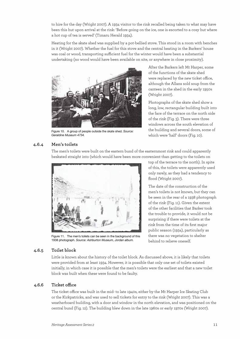
Figure 10. A group of people outside the skate shed. Source: Geraldine Museum 4734.
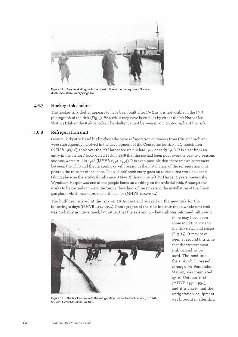
Figure 11. The men’s toilets can be seen in the background of this 1938 photograph. Source: Ashburton Museum, Jordan album.
12 Watson—Mt Harper ice rink
4.6.7 Hockey rink shelterThe hockey rink shelter appears to have been built after 1947, as it is not visible in the 1947 photograph of the rink (Fig. 5). As such, it may have been built by either the Mt Harper Ice Skating Club or the Kirkpatricks. The shelter cannot be seen in any photographs of the rink.
4.6.8 Refrigeration unitGeorge Kirkpatrick and his brother, who were refrigeration engineers from Christchurch and were subsequently involved in the development of the Centaurus ice rink in Christchurch (NZISA 1987: 8), took over the Mt Harper ice rink in late 1947 or early 1948. It is clear from an entry in the visitors’ book dated 14 July 1948 that the ice had been poor over the past two seasons and was worse still in 1948 (MHVB 1934–1954). It is even possible that there was an agreement between the Club and the Kirkpatricks with regard to the installation of the refrigeration unit prior to the transfer of the lease. The visitors’ book entry goes on to state that work had been taking place on the artificial rink since 8 May. Although he left Mt Harper 2 years previously, Wyndham Harper was one of the people listed as working on the artificial rink. Amongst the works to be carried out were the ‘proper levelling’ of the rinks and the installation of the Freon gas plant, which would provide artificial ice (MHVB 1934–1954).
The bulldozer arrived at the rink on 26 August and worked on the new rink for the following 2 days (MHVB 1934–1954). Photographs of the rink indicate that a whole new rink was probably not developed, but rather that the existing hockey rink was reformed—although
there may have been some modifications to the rink’s size and shape (Fig. 13). It may have been at around this time that the westernmost rink ceased to be used. The road into the rink, which passed through Mt Possession Station, was completed by 19 October 1948 (MHVB 1934–1954), and it is likely that the refrigeration equipment was brought in after this.
Figure 12. People skating, with the ticket office in the background. Source: Ashburton Museum clippings file.
Figure 13. The hockey rink with the refrigeration unit in the background, c. 1949. Source: Geraldine Museum 1830.

13Heritage Assessment Series 2
This equipment was installed in a weatherboard building at the western end of the rink and the ice was frozen by pipes running through the water (B. Allan, pers. comm.).
The refrigeration unit did not prove a success at Mt Harper and the Kirkpatricks sold their interest in the rink in 1949. The refrigeration plant was subsequently moved to the skating rink in Timaru (near Smiths City) and later to the Centaurus rink in Christchurch (Wright 2007).
4.7 Hydro power schemePhotographs indicate that a hydro power scheme had been installed at the Mt Harper ice rink by the 1938 season. No power poles or lampposts can be seen along the broad central bund in the 1937 photograph of the rink (Fig. 3), but the poles were present in 1938. Barker may have been planning this addition to the rink for some time, however, as a 1934 Timaru Herald article discussed the possibility of using electricity at the rink:
Nearby is a waterfall which could be utilised to develop electric power up to 200 kilowatts. In this way the skating rinks could be illuminated by electric flood lights for night skating in a similar manner to that used on many open-air ice rinks in Switzerland. (Timaru Herald 1934)
The article also mentioned that Barker had a 5-year plan for the development of the rink, which no doubt included the installation of electricity.
Brown Brothers from Christchurch installed the plant, which used a Pelton wheel to generate electricity, at the same time as they installed power at the Harper Lodge and Rata Peaks Station. The power scheme at the rink provided electricity for heating and cooking, as well as for lighting the rink—the lights were used for night skating on Wednesday nights and weekends (Wright 2007).
4.8 Skating at Mt Harper ice rinkIn spite of its remote location, skating at the Mt Harper ice rink proved highly popular, attracting skaters from around Canterbury and as far afield as Reefton (MHVB 1934–1954). In one year, 400 skaters attended the opening of the rink at the start of the season (Anon. n.d.b) and apparently at one point 3000 people attended the rink in a single day, including 12 busloads from Christchurch2 (Wright 2007). Not only did people skate at the rink, but they also played ice hockey there, and could enjoy skate sailing, ice yachting and curling. Chairs, wooden horses and toboggans were also available and, for the more adventurous, there was a motorbike with a chain that was used to tow people over the ice (Anon. n.d.a; Lee 1940). When Barbara Lee visited the rink in 1940, someone attempted to provide music for the skaters; however, the oil in the gramophone was chilled by the low temperatures to such an extent that the gramophone would not work (the temperatures had a similar effect on people’s watches; Lee 1940).
Entrance to the rink for a day’s skating cost 2/6 (Wright 2007). Richie Taylor can recall being greeted by Mrs Barker at the gate next to the Barkers’ house upon arrival at the rink (R. Taylor, pers. comm.). This may also have been where the entrance money was collected.
As well as being used for recreational skating, Mt Harper ice rink hosted speed skating events in the 1940s and 1950s. The distances raced were 220 yards, 880 yards and 1½ miles, all on a 220-yard (201.168-m) track (NZISA 1987: 9). However, New Zealand Ice Skating Association (NZISA) Figure Championships were never held at Mt Harper, the preferred early venues being Manorburn Dam (Alexandra), Tekapo and Idaburn Dam (near Oturehua; NZISA 1987: 33). Ice hockey was also a significant event at the rink, as can be seen through its association with the
2 It has not been possible to verify this number.

14 Watson—Mt Harper ice rink
Erewhon Cup. At least one Erewhon Cup match was played there, in 1938, which the Tekapo team (complete with Bill Hamilton) won (MHVB 1934–1954)—indeed, Mt Harper only won the Erewhon Cup once, which was the first time it was played for in 1937 (NZISA 1987: 16). Richie Taylor (pers. comm.) noted that Tekapo and Opawa were the only other rinks (in Canterbury?) with full-sized hockey pitches.
Skaters who wished to stay overnight near the rink (rather than make the lengthy journey into the Rangitata Gorge) could stay at the Harper Lodge, near Rata Peak Station on the south bank of the Rangitata River. This lodge was built in 1935 on 5 acres of freehold land bought out of Rata Peak Station by Marjorie Woolley. Miss Woolley, a sister of Sir Leonard Woolley (a famous archaeologist), operated the lodge, which was built along similar lines to the Barkers’ house—corrugated iron cladding, timber lining, and mud and tussock insulation (Kerr-North 1984). The lodge proved popular, often housing more than the 12 guests it was designed to accommodate.
The lodge operated until the early 1950s. In 1955, it was bought by Malcolm Prouting (Mesopotamia Station). Prouting moved half of the building to Mesopotamia in December 1955 and sold the other half to Andy Taylor (Ben McLeod Station) in 1957. Taylor enlarged this half and moved into it when Richie Taylor (Andy’s son) took over Ben McLeod. In 1964, the Taylor half of the lodge was incorporated into Rata Peaks Station. Marion Seymour (formerly of Rata Peaks) sold the lodge to a family consortium in 1998 and the lodge is now used as a bach by this group (R. Taylor, pers. comm.).
4.9 Demise of the rinkPublic use of the rink ceased in the mid-1950s. A number of reasons have been offered to explain its demise, including the increasingly warm winters (as noted in the visitors’ book; MHVB 1934–1954); a flood that significantly altered the course of the river, making it difficult to cross; and petrol rationing during and after World War II (Wright 2007). Another reason may have been the increasing popularity and availability of other weekend and evening entertainment (in more readily accessible locations), such as movies and dances, as well as the opening of indoor rinks in both Timaru (1951) and Christchurch (1952; NZISA 1987: 6), which were more accessible and had more reliable ice. It is likely that it was a combination of all these factors.
The Allan family continued to flood and freeze the rink into the early 1970s, travelling across the river in an old Army V8 (Wright 2007). Since then, the rink has been abandoned.
5. Physical description
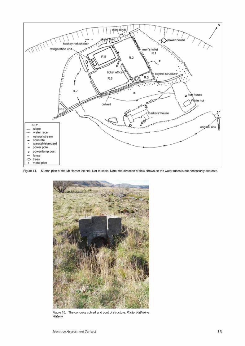
The features recorded during the archaeological survey are shown in Fig. 14.
5.1 The original rinkThe remains of the original rink indicate that it was triangular in shape and located c. 300 m from the base of the terrace that formed one side of the later rink. The bunds that surrounded the rink are still clearly visible and can be easily walked along. There was one break in the bund in the northeast corner, where a natural stream flowed out of the rink, and a water race fed the dam in the same area through a concrete culvert (Fig. 15). An associated concrete structure was used to control the amount of water in the rink using timber boards that slotted into the opening in the concrete. The water race carried water from the same natural stream that flowed into the dam—it is unlikely to have carried all o f the water from that stream, but may have taken sufficient so that the remaining water in the natural stream would have frozen. Much of the length of the water race was planted with poplar trees on both sides.
15Heritage Assessment Series 2
Figure 14. Sketch plan of the Mt Harper ice rink. Not to scale. Note: the direction of flow shown on the water races is not necessarily accurate.
Figure 15. The concrete culvert and control structure. Photo: Katharine Watson.
16 Watson—Mt Harper ice rink
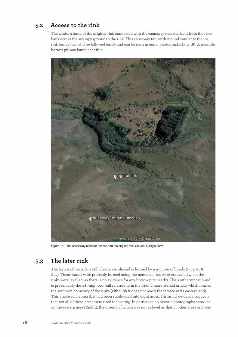
5.2 Access to the rinkThe western bund of the original rink connected with the causeway that was built from the river bank across the swampy ground to the rink. This causeway (an earth mound similar to the ice rink bunds) can still be followed easily and can be seen in aerial photographs (Fig. 16). A possible borrow pit was found near this.
Figure 16. The causeway used for access and the original rink. Source: Google Earth.
5.3 The later rinkThe layout of the rink is still clearly visible and is formed by a number of bunds (Figs 14, 16 & 17). These bunds were probably formed using the materials that were excavated when the rinks were levelled, as there is no evidence for any borrow pits nearby. The southernmost bund is presumably the 4-ft-high sod wall referred to in the 1934 Timaru Herald article, which formed the southern boundary of the rinks (although it does not reach the terrace at its eastern end). This enclosed an area that had been subdivided into eight areas. Historical evidence suggests that not all of these areas were used for skating. In particular, no historic photographs show ice on the eastern area (Rink 1), the ground of which was not as level as that in other areas and was
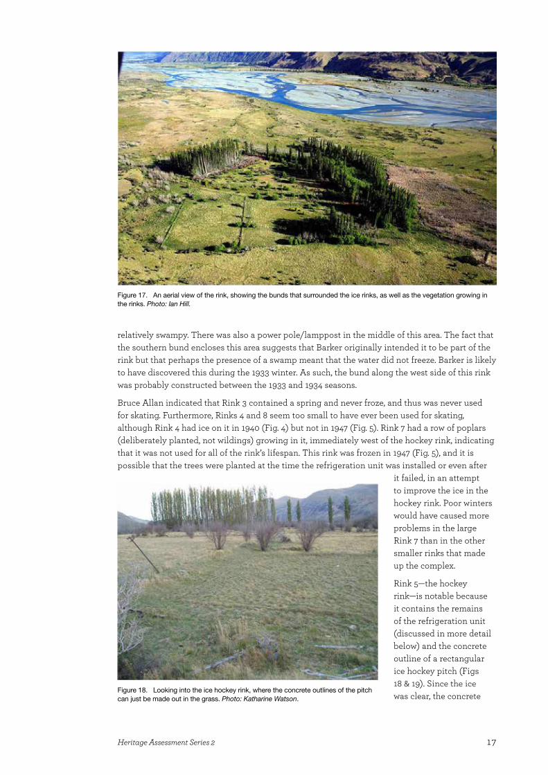
17Heritage Assessment Series 2
relatively swampy. There was also a power pole/lamppost in the middle of this area. The fact that the southern bund encloses this area suggests that Barker originally intended it to be part of the rink but that perhaps the presence of a swamp meant that the water did not freeze. Barker is likely to have discovered this during the 1933 winter. As such, the bund along the west side of this rink was probably constructed between the 1933 and 1934 seasons.
Bruce Allan indicated that Rink 3 contained a spring and never froze, and thus was never used for skating. Furthermore, Rinks 4 and 8 seem too small to have ever been used for skating, although Rink 4 had ice on it in 1940 (Fig. 4) but not in 1947 (Fig. 5). Rink 7 had a row of poplars (deliberately planted, not wildings) growing in it, immediately west of the hockey rink, indicating that it was not used for all of the rink’s lifespan. This rink was frozen in 1947 (Fig. 5), and it is possible that the trees were planted at the time the refrigeration unit was installed or even after
it failed, in an attempt to improve the ice in the hockey rink. Poor winters would have caused more problems in the large Rink 7 than in the other smaller rinks that made up the complex.
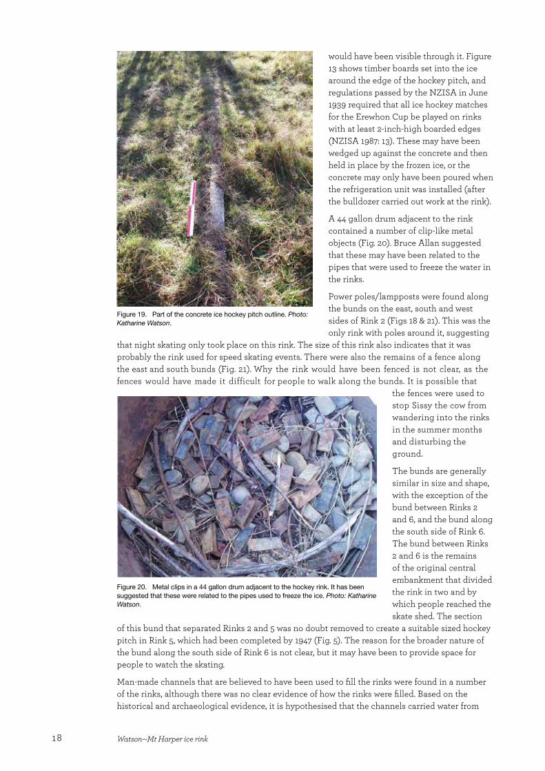
Rink 5—the hockey rink—is notable because it contains the remains of the refrigeration unit (discussed in more detail below) and the concrete outline of a rectangular ice hockey pitch (Figs 18 & 19). Since the ice was clear, the concrete
Figure 17. An aerial view of the rink, showing the bunds that surrounded the ice rinks, as well as the vegetation growing in the rinks. Photo: Ian Hill.
Figure 18. Looking into the ice hockey rink, where the concrete outlines of the pitch can just be made out in the grass. Photo: Katharine Watson.
18 Watson—Mt Harper ice rink
Figure 19. Part of the concrete ice hockey pitch outline. Photo: Katharine Watson.
would have been visible through it. Figure 13 shows timber boards set into the ice around the edge of the hockey pitch, and regulations passed by the NZISA in June 1939 required that all ice hockey matches for the Erewhon Cup be played on rinks with at least 2-inch-high boarded edges (NZISA 1987: 13). These may have been wedged up against the concrete and then held in place by the frozen ice, or the concrete may only have been poured when the refrigeration unit was installed (after the bulldozer carried out work at the rink).
A 44 gallon drum adjacent to the rink contained a number of clip-like metal objects (Fig. 20). Bruce Allan suggested that these may have been related to the pipes that were used to freeze the water in the rinks.
Power poles/lampposts were found along the bunds on the east, south and west sides of Rink 2 (Figs 18 & 21). This was the only rink with poles around it, suggesting
that night skating only took place on this rink. The size of this rink also indicates that it was probably the rink used for speed skating events. There were also the remains of a fence along the east and south bunds (Fig. 21). Why the rink would have been fenced is not clear, as the fences would have made it difficult for people to walk along the bunds. It is possible that
the fences were used to stop Sissy the cow from wandering into the rinks in the summer months and disturbing the ground.
The bunds are generally similar in size and shape, with the exception of the bund between Rinks 2 and 6, and the bund along the south side of Rink 6. The bund between Rinks 2 and 6 is the remains of the original central embankment that divided the rink in two and by which people reached the skate shed. The section
of this bund that separated Rinks 2 and 5 was no doubt removed to create a suitable sized hockey pitch in Rink 5, which had been completed by 1947 (Fig. 5). The reason for the broader nature of the bund along the south side of Rink 6 is not clear, but it may have been to provide space for people to watch the skating.
Man-made channels that are believed to have been used to fill the rinks were found in a number of the rinks, although there was no clear evidence of how the rinks were filled. Based on the historical and archaeological evidence, it is hypothesised that the channels carried water from
Figure 20. Metal clips in a 44 gallon drum adjacent to the hockey rink. It has been suggested that these were related to the pipes used to freeze the ice. Photo: Katharine Watson.
19Heritage Assessment Series 2
Figure 21. Power poles/lampposts along the bund on the east side of Rink 2. Photo: Katharine Watson.
Figure 22. A gap in a bund to enable the flow of water between rinks. Photo: Katharine Watson.
Figure 23. The control structure in the southwest corner of Rink 1. Photo: Katharine Watson.
the spring (in Rink 3 and possibly from Rink 1; see below) to the rinks. Gaps in the bunds around each rink would have ensured the flow of water (Fig. 22). No evidence of how the water was controlled was found, although there was a concrete control structure towards the east end of the south bund (i.e. on the exterior of the rink; Fig. 23). The presence of a channel on the south side of this structure would have suggested that it was used to control the flow of water into the rinks. However, in the absence of such a channel, alternative theories must be considered. The structure (which is associated with Rink 1) was presumably used to dam the eastern area of the rinks and may have only been used during the 1933 season. Alternatively, the structure may have dammed the swampy eastern area and the water that pooled in this area may have been used to flood the other rinks.
The channels pose a number of questions. No channels were found in Rinks 2, 5 and 6, the only rinks in use at the end of the complex’s life, and this is unlikely to be a coincidence. Were the channels originally present in these rinks but subsequently filled in (possibly by the bulldozer), or were they a later feature? Water from these channels would only have flooded Rinks 3, 4 and 7 if they overflowed, as the channels had been dug into the floor of the rinks and there was no outlet from them in these rinks. One of the channels continues to the westernmost point of the rinks (Rink 8), where it is separated from a natural stream by the southern bund. There was no evidence of a culvert through the bund here, indicating that there was no connection between the stream and the channel. Since Rink 8 was not a swampy area, water was unlikely to have been collected here. Therefore, this suggests that the channels date from the early years of the rink’s operation.
20 Watson—Mt Harper ice rink
A notable feature of Rink 6 is the presence of a wing wall next to the gap in the bund between this rink and Rink 2, which was present in 1947 (Fig. 5). The purpose of the wing wall is not clear. It is possible that it was used to channel the flow of water or it may have been used to slow skaters down as they moved between rinks. It should be noted that this gap in the bund was the only one that would have been big enough to skate through. This gap was not visible in the 1947 photograph and so may post-date this—although this may also be due to the quality of the image. The gap is unlikely to have been an original feature as it would not have been possible to walk all the way along the central embankment to the refreshment house with this gap in the central embankment. This gap may have been one of the reasons why the ticket office was built.
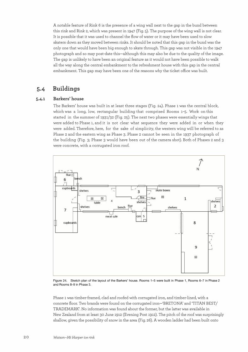
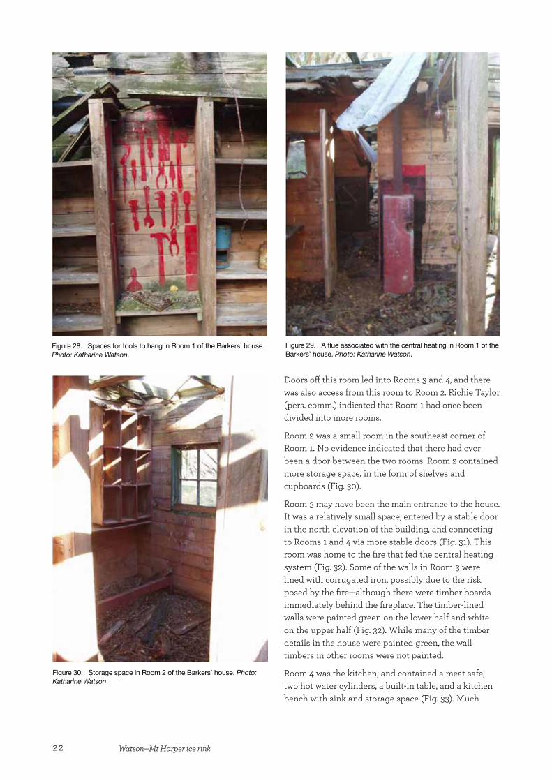
5.4 Buildings 5.4.1 Barkers’ house
The Barkers’ house was built in at least three stages (Fig. 24). Phase 1 was the central block, which was a long, low, rectangular building that comprised Rooms 1–5. Work on this started in the summer of 1931/32 (Fig. 25). The next two phases were essentially wings that were added to Phase 1, and it is not clear what sequence they were added in or when they were added. Therefore, here, for the sake of simplicity, the western wing will be referred to as Phase 2 and the eastern wing as Phase 3. Phase 2 cannot be seen in the 1937 photograph of the building (Fig. 3; Phase 3 would have been out of the camera shot). Both of Phases 2 and 3 were concrete, with a corrugated iron roof.
Figure 24. Sketch plan of the layout of the Barkers’ house. Rooms 1–5 were built in Phase 1, Rooms 6–7 in Phase 2 and Rooms 8–9 in Phase 3.
Phase 1 was timber-framed, clad and roofed with corrugated iron, and timber-lined, with a concrete floor. Two brands were found on the corrugated iron—‘BRETONA’ and ‘TITAN BEST/TRADEMARK’. No information was found about the former, but the latter was available in New Zealand from at least 30 June 1912 (Evening Post 1912). The pitch of the roof was surprisingly shallow, given the possibility of snow in the area (Fig. 26). A wooden ladder had been built onto
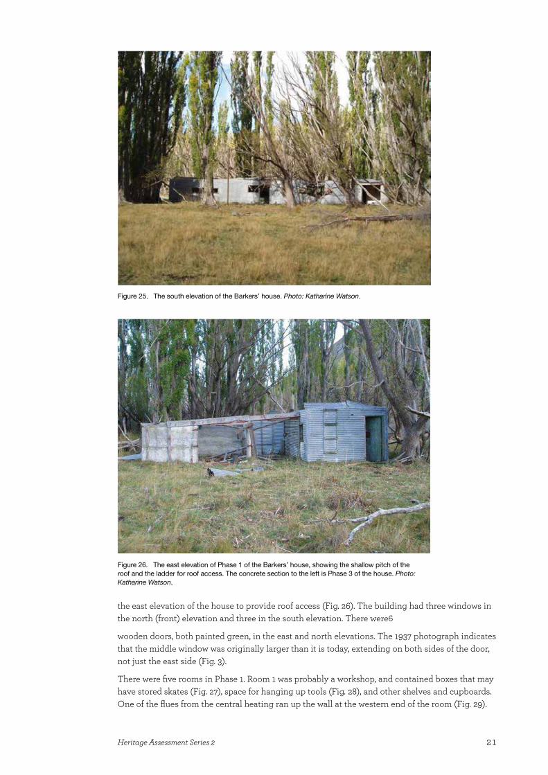
21Heritage Assessment Series 2
Figure 25. The south elevation of the Barkers’ house. Photo: Katharine Watson.
Figure 26. The east elevation of Phase 1 of the Barkers’ house, showing the shallow pitch of the roof and the ladder for roof access. The concrete section to the left is Phase 3 of the house. Photo: Katharine Watson.
the east elevation of the house to provide roof access (Fig. 26). The building had three windows in the north (front) elevation and three in the south elevation. There were6
wooden doors, both painted green, in the east and north elevations. The 1937 photograph indicates that the middle window was originally larger than it is today, extending on both sides of the door, not just the east side (Fig. 3).
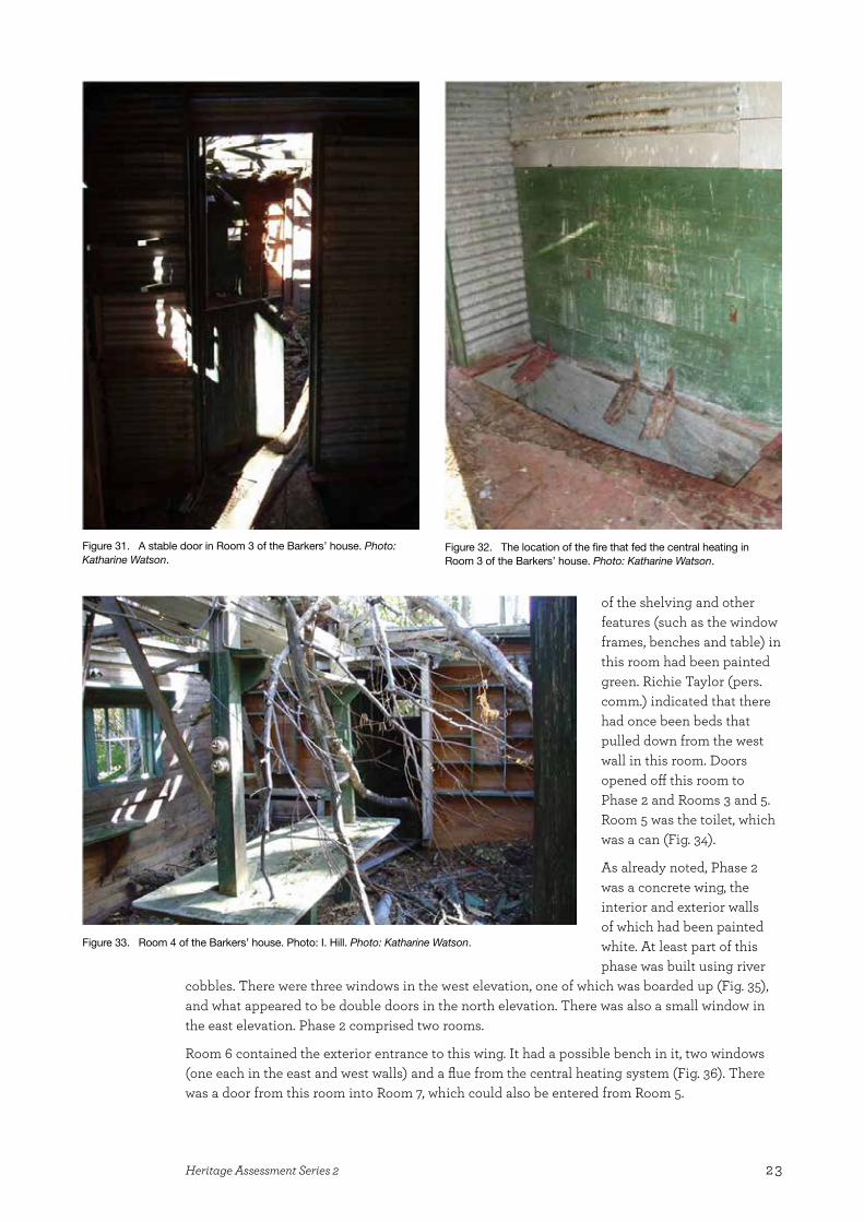
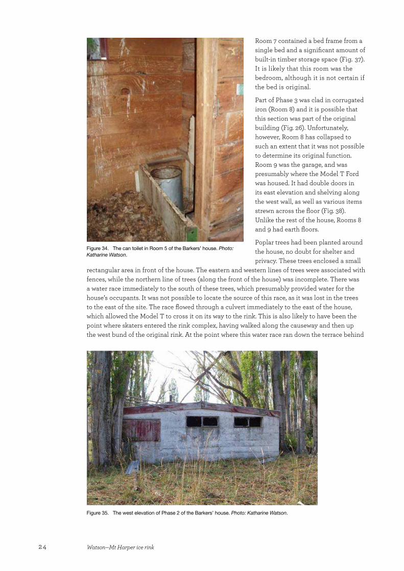
There were five rooms in Phase 1. Room 1 was probably a workshop, and contained boxes that may have stored skates (Fig. 27), space for hanging up tools (Fig. 28), and other shelves and cupboards. One of the flues from the central heating ran up the wall at the western end of the room (Fig. 29).
22 Watson—Mt Harper ice rink
Figure 28. Spaces for tools to hang in Room 1 of the Barkers’ house. Photo: Katharine Watson.
Figure 29. A flue associated with the central heating in Room 1 of the Barkers’ house. Photo: Katharine Watson.
Doors off this room led into Rooms 3 and 4, and there was also access from this room to Room 2. Richie Taylor (pers. comm.) indicated that Room 1 had once been divided into more rooms.
Room 2 was a small room in the southeast corner of Room 1. No evidence indicated that there had ever been a door between the two rooms. Room 2 contained more storage space, in the form of shelves and cupboards (Fig. 30).
Room 3 may have been the main entrance to the house. It was a relatively small space, entered by a stable door in the north elevation of the building, and connecting to Rooms 1 and 4 via more stable doors (Fig. 31). This room was home to the fire that fed the central heating system (Fig. 32). Some of the walls in Room 3 were lined with corrugated iron, possibly due to the risk posed by the fire—although there were timber boards immediately behind the fireplace. The timber-lined walls were painted green on the lower half and white on the upper half (Fig. 32). While many of the timber details in the house were painted green, the wall timbers in other rooms were not painted.
Room 4 was the kitchen, and contained a meat safe, two hot water cylinders, a built-in table, and a kitchen bench with sink and storage space (Fig. 33). Much
Figure 30. Storage space in Room 2 of the Barkers’ house. Photo: Katharine Watson.
23Heritage Assessment Series 2
Figure 31. A stable door in Room 3 of the Barkers’ house. Photo: Katharine Watson.
Figure 32. The location of the fire that fed the central heating in Room 3 of the Barkers’ house. Photo: Katharine Watson.
of the shelving and other features (such as the window frames, benches and table) in this room had been painted green. Richie Taylor (pers. comm.) indicated that there had once been beds that pulled down from the west wall in this room. Doors opened off this room to Phase 2 and Rooms 3 and 5. Room 5 was the toilet, which was a can (Fig. 34).
As already noted, Phase 2 was a concrete wing, the interior and exterior walls of which had been painted white. At least part of this phase was built using river
cobbles. There were three windows in the west elevation, one of which was boarded up (Fig. 35), and what appeared to be double doors in the north elevation. There was also a small window in the east elevation. Phase 2 comprised two rooms.
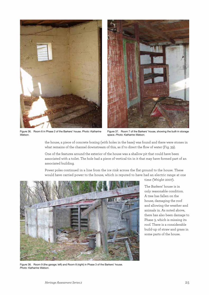
Room 6 contained the exterior entrance to this wing. It had a possible bench in it, two windows (one each in the east and west walls) and a flue from the central heating system (Fig. 36). There was a door from this room into Room 7, which could also be entered from Room 5.
Figure 33. Room 4 of the Barkers’ house. Photo: I. Hill. Photo: Katharine Watson.
24 Watson—Mt Harper ice rink
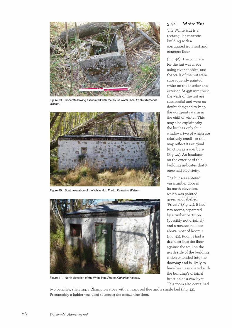
Room 7 contained a bed frame from a single bed and a significant amount of built-in timber storage space (Fig. 37). It is likely that this room was the bedroom, although it is not certain if the bed is original.
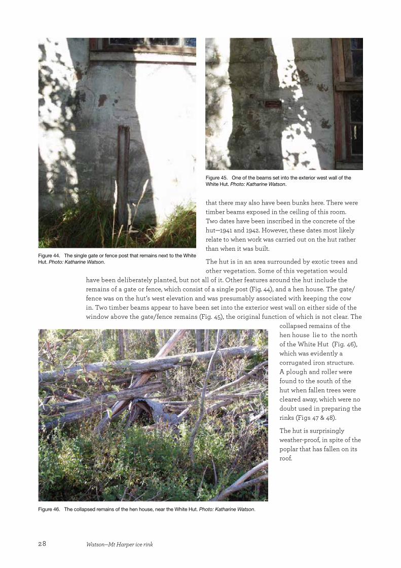
Part of Phase 3 was clad in corrugated iron (Room 8) and it is possible that this section was part of the original building (Fig. 26). Unfortunately, however, Room 8 has collapsed to such an extent that it was not possible to determine its original function. Room 9 was the garage, and was presumably where the Model T Ford was housed. It had double doors in its east elevation and shelving along the west wall, as well as various items strewn across the floor (Fig. 38). Unlike the rest of the house, Rooms 8 and 9 had earth floors.
Poplar trees had been planted around the house, no doubt for shelter and privacy. These trees enclosed a small
rectangular area in front of the house. The eastern and western lines of trees were associated with fences, while the northern line of trees (along the front of the house) was incomplete. There was a water race immediately to the south of these trees, which presumably provided water for the house’s occupants. It was not possible to locate the source of this race, as it was lost in the trees to the east of the site. The race flowed through a culvert immediately to the east of the house, which allowed the Model T to cross it on its way to the rink. This is also likely to have been the point where skaters entered the rink complex, having walked along the causeway and then up the west bund of the original rink. At the point where this water race ran down the terrace behind
Figure 34. The can toilet in Room 5 of the Barkers’ house. Photo: Katharine Watson.
Figure 35. The west elevation of Phase 2 of the Barkers’ house. Photo: Katharine Watson.
25Heritage Assessment Series 2
the house, a piece of concrete boxing (with holes in the base) was found and there were stones in what remains of the channel downstream of this, as if to direct the flow of water (Fig. 39).
One of the features around the exterior of the house was a shallow pit that could have been associated with a toilet. The hole had a piece of vertical tin in it that may have formed part of an associated building.
Power poles continued in a line from the ice rink across the flat ground to the house. These would have carried power to the house, which is reputed to have had an electric range at one
time (Wright 2007).
The Barkers’ house is in only reasonable condition. A tree has fallen on the house, damaging the roof and allowing the weather and animals in. As noted above, there has also been damage to Phase 3, which is missing its roof. There is a considerable build-up of straw and grass in some parts of the house.
Figure 36. Room 6 in Phase 2 of the Barkers’ house. Photo: Katharine Watson.
Figure 37. Room 7 of the Barkers’ house, showing the built-in storage space. Photo: Katharine Watson.
Figure 38. Room 9 (the garage; left) and Room 8 (right) in Phase 3 of the Barkers’ house. Photo: Katharine Watson.
26 Watson—Mt Harper ice rink
5.4.2 White HutThe White Hut is a rectangular concrete building with a corrugated iron roof and concrete floor
(Fig. 40). The concrete for the hut was made using river cobbles, and the walls of the hut were subsequently painted white on the interior and exterior. At 450 mm thick, the walls of the hut are substantial and were no doubt designed to keep the occupants warm in the chill of winter. This may also explain why the hut has only four windows, two of which are relatively small—or this may reflect its original function as a cow byre (Fig. 40). An insulator on the exterior of this building indicates that it once had electricity.
The hut was entered via a timber door in its north elevation, which was painted green and labelled ‘Private’ (Fig. 41). It had two rooms, separated by a timber partition (possibly not original), and a mezzanine floor above most of Room 1 (Fig. 42). Room 1 had a drain set into the floor against the wall on the north side of the building, which extended into the doorway and is likely to have been associated with the building’s original function as a cow byre. This room also contained
two benches, shelving, a Champion stove with an exposed flue and a single bed (Fig. 43). Presumably a ladder was used to access the mezzanine floor.
Figure 39. Concrete boxing associated with the house water race. Photo: Katharine Watson.
Figure 40. South elevation of the White Hut. Photo: Katharine Watson.
Figure 41. North elevation of the White Hut. Photo: Katharine Watson.

27Heritage Assessment Series 2
Figure 42. Sketch plan of the layout of the White Hut.
Figure 43. Room 1 of the White Hut. Photo: Ian Hill.
The timber partition between Rooms 1 and 2 was only about half the width of the building and there was no door between the two rooms. A built-in table occupied some of this space. There were two small windows in Room 2, which contained two sets of bunks, a free-standing bench (for sitting on) and a built-in three-quarter bed. The remains of posts around the built-in bed suggest
28 Watson—Mt Harper ice rink
that there may also have been bunks here. There were timber beams exposed in the ceiling of this room. Two dates have been inscribed in the concrete of the hut—1941 and 1942. However, these dates most likely relate to when work was carried out on the hut rather than when it was built.
The hut is in an area surrounded by exotic trees and other vegetation. Some of this vegetation would
have been deliberately planted, but not all of it. Other features around the hut include the remains of a gate or fence, which consist of a single post (Fig. 44), and a hen house. The gate/fence was on the hut’s west elevation and was presumably associated with keeping the cow in. Two timber beams appear to have been set into the exterior west wall on either side of the window above the gate/fence remains (Fig. 45), the original function of which is not clear. The
collapsed remains of the hen house lie to the north of the White Hut (Fig. 46), which was evidently a corrugated iron structure. A plough and roller were found to the south of the hut when fallen trees were cleared away, which were no doubt used in preparing the rinks (Figs 47 & 48).
The hut is surprisingly weather-proof, in spite of the poplar that has fallen on its roof.
Figure 44. The single gate or fence post that remains next to the White Hut. Photo: Katharine Watson.
Figure 46. The collapsed remains of the hen house, near the White Hut. Photo: Katharine Watson.
Figure 45. One of the beams set into the exterior west wall of the White Hut. Photo: Katharine Watson.
29Heritage Assessment Series 2
5.4.3 Skate shedThe skate shed was set back into the face of the terrace on the north side of the rinks. Its remains comprise a series of concrete walls (Figs 49 & 50). As with the cow byre and part of the Barkers’ house, the concrete was made using river cobbles. There appear to have been at least three rooms in the hut—it is possible that the area under the concrete roof may have been two separate rooms, rather than part of Rooms 1 and 2. Room 1 was the smallest of the rooms and its original function is not known. Room 2 was where food was served and Room 3 was the skate hire area (R. Taylor, pers. comm.), and possibly also the location of the ‘skating library’ and the ‘library of skating pictures’. One of the concrete walls of this room has collapsed, and vegetation is growing throughout the structure.
Other features in the area include what is essentially a concrete curb that continues along the base of the terrace to the west of Room 1, a small concrete box lined with metal (Fig. 51), and a wooden post, ditch and scattered rubbish on the terrace above the shed. The ditch is probably natural.
Figure 48. A roller found near the White Hut, no doubt also used for preparing and/or maintaining the rinks. Photo: Katharine Watson.
Figure 47. A plough found near the White Hut, no doubt used for preparing and/or maintaining the rinks. Photo: Katharine Watson.
Figure 49. Sketch plan showing the remains of the skate shed.
30 Watson—Mt Harper ice rink
5.4.4 Men’s toiletsThe remains of the men’s toilets are on the bund between Rinks 1 and 2. These remains comprise a 40-gallon drum set into the ground (i.e. the toilet was a long drop), a concrete wall and the remains of a timber structure (Fig. 52). There are cracks in the concrete and vegetation growing around the remains of the structure.
5.4.5 Toilet blockThe toilet block was situated on top of the terrace to the north of the rinks (and must have been difficult to reach with skates on). The remains comprise a hole in the ground (another long drop toilet), standards with wires attached to them (possibly anchors for the building), waratahs, metal pipes (some of which also had wire attached to them), and scattered timber and corrugated iron (Fig. 53).
5.4.6 Ticket officeThe remains of the ticket office are on the bund to the east of Rink 6. All that remains of the office are the rectangular concrete foundation and some scattered timbers (Fig. 54). Some vegetation is growing at the east end of the building remains.
Figure 52. The remains of the men’s toilets—the concrete wall in the background and the barrel in the foreground. Photo: Katharine Watson.
Figure 50. The skate shed, looking northeast. Photo: Katharine Watson. Figure 51. A small concrete box lined with metal, near the skate shed. Photo: Katharine Watson.
Figure 53. The remains of the toilet block—some waratahs and fencing wire. Photo: Katharine Watson.
31Heritage Assessment Series 2
Figure 55. The collapsed remains of the hockey rink shelter on the bank above the hockey rink, looking northeast. Photo: Katharine Watson.
Figure 54. The foundations of the ticket office. Photo: Katharine Watson.
Figure 56. The concrete foundations of the refrigeration unit at the hockey rink. Photo: Katharine Watson.
5.4.7 Hockey rink shelterThe hockey shelter was on the same terrace as the toilet block, but to the west, looking out over the hockey rink. The remains of the building comprise the concrete foundations and a collapsed weatherboard wall (Fig. 55). There is vegetation growing within the remains.
5.4.8 Refrigeration unitThe remains of the refrigeration unit are at the west end of the hockey rink and are now overgrown. As for a number of the other buildings, the remains comprise the concrete foundations (Fig. 56). These foundations have metal bolts protruding from them. There are four small concrete blocks within the foundations at the south end, which are likely to have been machine supports.
5.4.9 Overall conditionThe remains of the buildings at the Mt Harper ice rink are an indication of the harsh environment. For the most part, the only buildings that have remains standing are the concrete buildings, with the timber-clad buildings all having succumbed to the elements (chiefly the nor’west winds). The Barkers’ house is an exception, possibly due to the corrugated iron being more resilient to the wind than timber, or the trees planted around the building protecting it.
32 Watson—Mt Harper ice rink
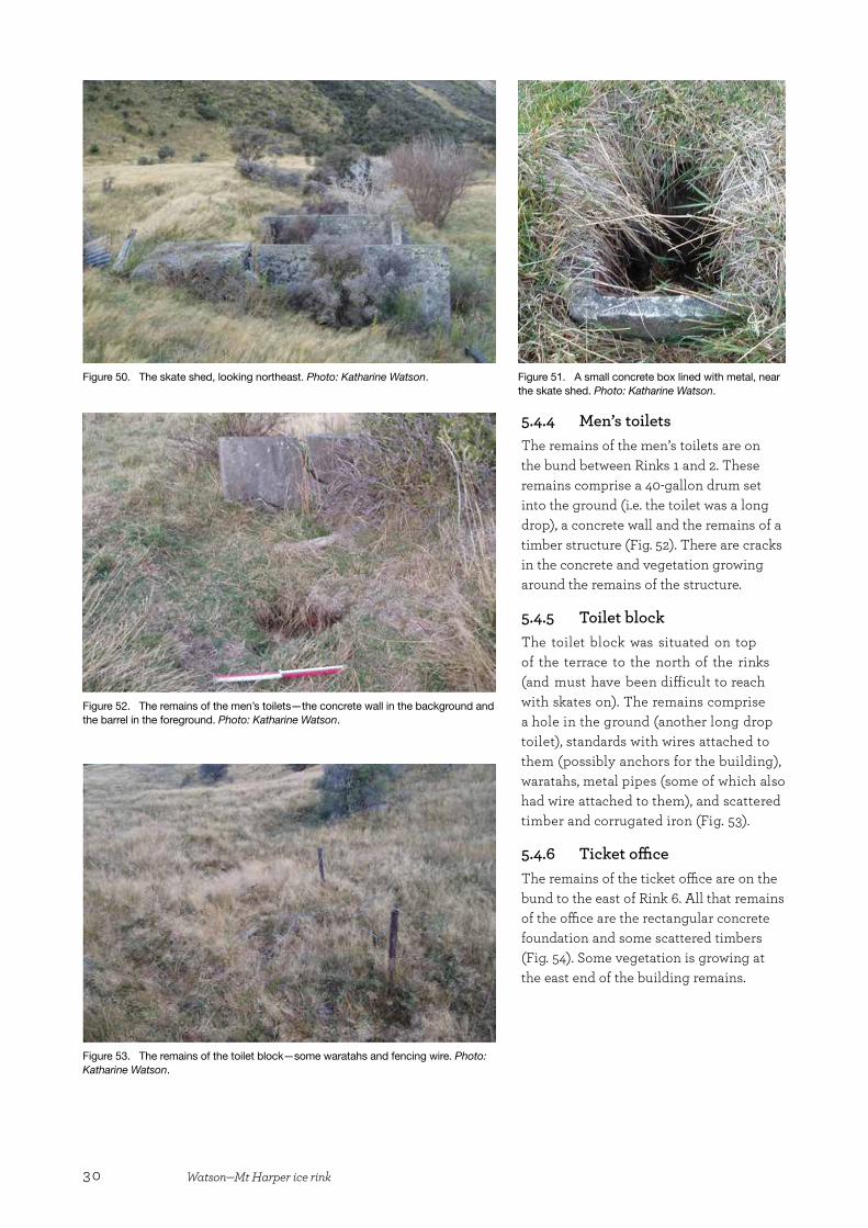
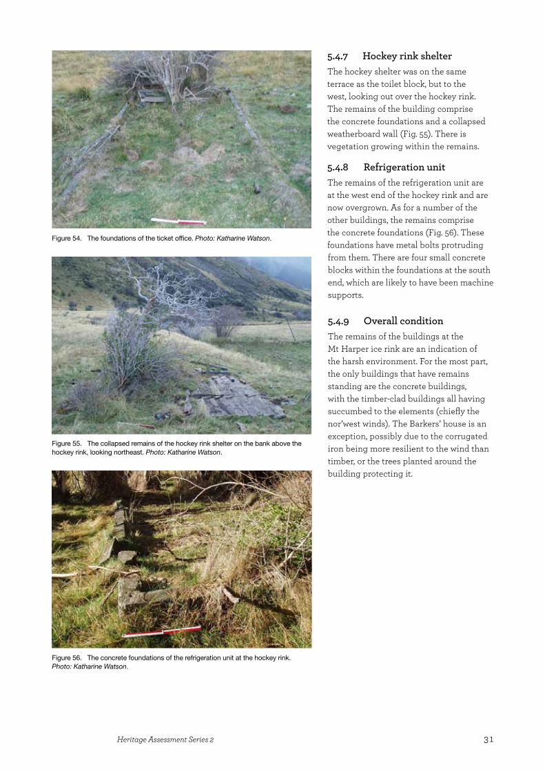
5.5 Hydro power schemeThe remains of the power scheme are reasonably complete, and comprise the power house and its associated infrastructure—the penstock and water race. It has not been possible to examine the water intake structure. The water race was flumed, piped and carried in an open ditch from the intake to the head of the penstock (Figs 57 & 58). The penstock is buried in scree for most of
Figure 57. The penstock buried in the scree. Photo: Ian Hill. Figure 58. The water race ditch on the slopes of Mt Harper/Mahaanui above the ice rink. Photo: Katharine Watson.
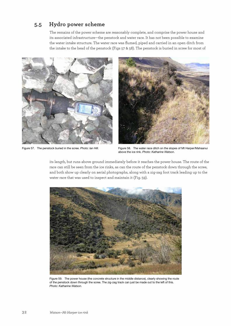
its length, but runs above ground immediately before it reaches the power house. The route of the race can still be seen from the ice rinks, as can the route of the penstock down through the scree, and both show up clearly on aerial photographs, along with a zig-zag foot track leading up to the water race that was used to inspect and maintain it (Fig. 59).
Figure 59. The power house (the concrete structure in the middle distance), clearly showing the route of the penstock down through the scree. The zig-zag track can just be made out to the left of this. Photo: Katharine Watson.
33Heritage Assessment Series 2
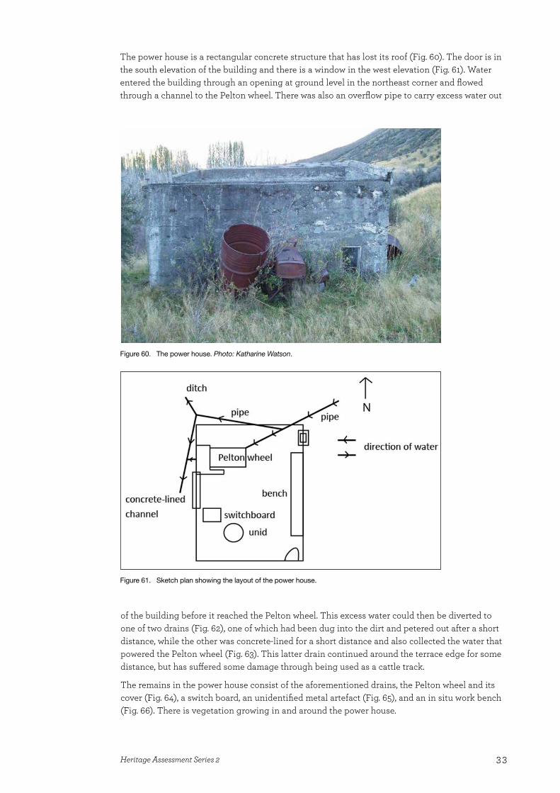
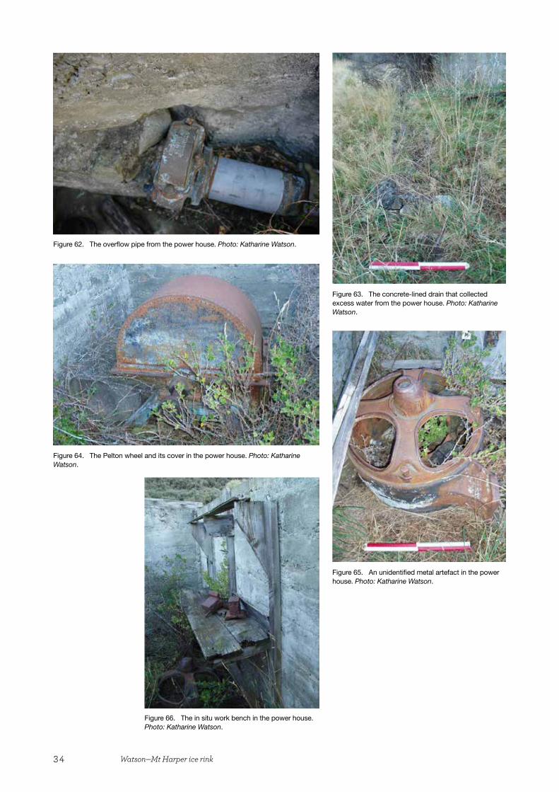
The power house is a rectangular concrete structure that has lost its roof (Fig. 60). The door is in the south elevation of the building and there is a window in the west elevation (Fig. 61). Water entered the building through an opening at ground level in the northeast corner and flowed through a channel to the Pelton wheel. There was also an overflow pipe to carry excess water out
of the building before it reached the Pelton wheel. This excess water could then be diverted to one of two drains (Fig. 62), one of which had been dug into the dirt and petered out after a short distance, while the other was concrete-lined for a short distance and also collected the water that powered the Pelton wheel (Fig. 63). This latter drain continued around the terrace edge for some distance, but has suffered some damage through being used as a cattle track.
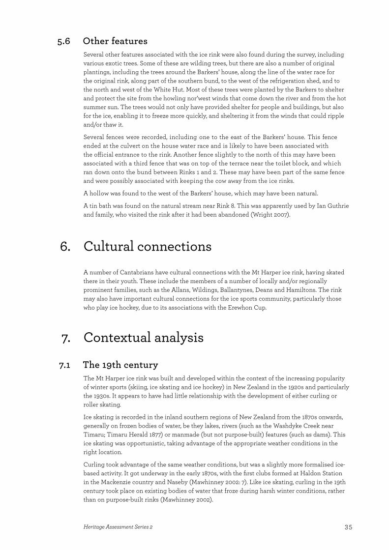
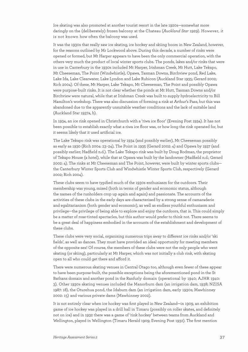
The remains in the power house consist of the aforementioned drains, the Pelton wheel and its cover (Fig. 64), a switch board, an unidentified metal artefact (Fig. 65), and an in situ work bench (Fig. 66). There is vegetation growing in and around the power house.
Figure 61. Sketch plan showing the layout of the power house.
Figure 60. The power house. Photo: Katharine Watson.
34 Watson—Mt Harper ice rink
Figure 66. The in situ work bench in the power house. Photo: Katharine Watson.
Figure 62. The overflow pipe from the power house. Photo: Katharine Watson.
Figure 63. The concrete-lined drain that collected excess water from the power house. Photo: Katharine Watson.
Figure 64. The Pelton wheel and its cover in the power house. Photo: Katharine Watson.
Figure 65. An unidentified metal artefact in the power house. Photo: Katharine Watson.
35Heritage Assessment Series 2
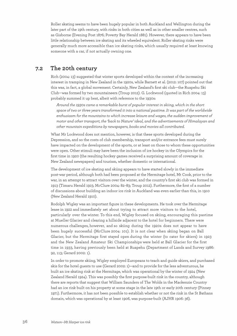
5.6 Other featuresSeveral other features associated with the ice rink were also found during the survey, including various exotic trees. Some of these are wilding trees, but there are also a number of original plantings, including the trees around the Barkers’ house, along the line of the water race for the original rink, along part of the southern bund, to the west of the refrigeration shed, and to the north and west of the White Hut. Most of these trees were planted by the Barkers to shelter and protect the site from the howling nor’west winds that come down the river and from the hot summer sun. The trees would not only have provided shelter for people and buildings, but also for the ice, enabling it to freeze more quickly, and sheltering it from the winds that could ripple and/or thaw it.
Several fences were recorded, including one to the east of the Barkers’ house. This fence ended at the culvert on the house water race and is likely to have been associated with the official entrance to the rink. Another fence slightly to the north of this may have been associated with a third fence that was on top of the terrace near the toilet block, and which ran down onto the bund between Rinks 1 and 2. These may have been part of the same fence and were possibly associated with keeping the cow away from the ice rinks.
A hollow was found to the west of the Barkers’ house, which may have been natural.
A tin bath was found on the natural stream near Rink 8. This was apparently used by Ian Guthrie and family, who visited the rink after it had been abandoned (Wright 2007).
6. Cultural connectionsA number of Cantabrians have cultural connections with the Mt Harper ice rink, having skated there in their youth. These include the members of a number of locally and/or regionally prominent families, such as the Allans, Wildings, Ballantynes, Deans and Hamiltons. The rink may also have important cultural connections for the ice sports community, particularly those who play ice hockey, due to its associations with the Erewhon Cup.
7. Contextual analysis
7.1 The 19th centuryThe Mt Harper ice rink was built and developed within the context of the increasing popularity of winter sports (skiing, ice skating and ice hockey) in New Zealand in the 1920s and particularly the 1930s. It appears to have had little relationship with the development of either curling or roller skating.
Ice skating is recorded in the inland southern regions of New Zealand from the 1870s onwards, generally on frozen bodies of water, be they lakes, rivers (such as the Washdyke Creek near Timaru; Timaru Herald 1877) or manmade (but not purpose-built) features (such as dams). This ice skating was opportunistic, taking advantage of the appropriate weather conditions in the right location.
Curling took advantage of the same weather conditions, but was a slightly more formalised ice-based activity. It got underway in the early 1870s, with the first clubs formed at Haldon Station in the Mackenzie country and Naseby (Mawhinney 2002: 7). Like ice skating, curling in the 19th century took place on existing bodies of water that froze during harsh winter conditions, rather than on purpose-built rinks (Mawhinney 2002).
36 Watson—Mt Harper ice rink
Roller skating seems to have been hugely popular in both Auckland and Wellington during the later part of the 19th century, with rinks in both cities as well as in other smaller centres, such as Gisborne (Evening Post 1876; Poverty Bay Herald 1881). However, there appears to have been little relationship between ice skating and its wheeled equivalent. Roller skating rinks were generally much more accessible than ice skating rinks, which usually required at least knowing someone with a car, if not actually owning one.
7.2 The 20th centuryRich (2004: 13) suggested that winter sports developed within the context of the increasing interest in tramping in New Zealand in the 1920s, while Barnett et al. (2012: 107) pointed out that this was, in fact, a global movement. Certainly, New Zealand’s first ski club—the Ruapehu Ski Club—was formed by two mountaineers (Troup 2012). G. Lockwood (quoted in Rich 2004: 13) probably summed it up best, albeit with reference to the 1930s:
Around the 1930s came a remarkable burst of popular interest in skiing, which in the short space of two or three years transformed it into a national pastime. It was part of the worldwide enthusiasm for the mountains to which increase leisure and wages, the sudden improvement of motor and other transport, the ‘back to Nature’ ideal, and the advertisements of Himalayan and other mountain expeditions by newspapers, books and movies all contributed.
What Mr Lockwood does not mention, however, is that these sports developed during the Depression, and so the costs of club membership, transport and/or entrance fees must surely have impacted on the development of the sports, or at least on those to whom these opportunities were open. Other stimuli may have been the inclusion of ice hockey in the Olympics for the first time in 1920 (the resulting hockey games received a surprising amount of coverage in New Zealand newspapers) and tourism, whether domestic or international.
The development of ice skating and skiing appears to have started slowly in the immediate post-war period, although both had been proposed at the Hermitage hotel, Mt Cook, prior to the war, in an attempt to attract visitors over the winter, and the country’s first ski club was formed in 1913 (Timaru Herald 1915; McClure 2004: 82–83; Troup 2012). Furthermore, the first of a number of discussions about building an indoor ice rink in Auckland was even earlier than this, in 1910 (New Zealand Herald 1910).
Rodolph Wigley was an important figure in these developments. He took over the Hermitage lease in 1922 and immediately set about trying to attract more visitors to the hotel, particularly over the winter. To this end, Wigley focused on skiing, encouraging this pastime at Mueller Glacier and clearing a hillside adjacent to the hotel for beginners. There were numerous challenges, however, and so skiing during the 1920s does not appear to have been hugely successful (McClure 2004: 101). It is not clear when skiing began on Ball Glacier, but the Hermitage first stayed open during the winter (to cater for skiers) in 1923 and the New Zealand Amateur Ski Championships were held at Ball Glacier for the first time in 1933, having previously been held at Ruapehu (Department of Lands and Survey 1986: 92, 113; Gerard 2002: 1).
In order to promote skiing, Wigley employed Europeans to teach and guide skiers, and purchased skis for the hotel guests to use (Gerard 2002: 1)—and to provide for the less adventurous, he built an ice skating rink at the Hermitage, which was operational by the winter of 1924 (New Zealand Herald 1924). This was possibly the first purpose-built rink in the country, although there are reports that suggest that William Saunders of The Wolds in the Mackenzie Country had an ice rink built on his property at some stage in the late 19th or early 20th century (Pinney 1971). Furthermore, it has not been possible to establish whether or not the rink in the St Bathans domain, which was operational by at least 1906, was purpose-built (AJHR 1906: 36).
37Heritage Assessment Series 2
Ice skating was also promoted at another tourist resort in the late 1920s—somewhat more daringly on the (deliberately) frozen balcony at the Chateau (Auckland Star 1929). However, it is not known how often the balcony was used.
It was the 1930s that really saw ice skating, ice hockey and skiing boom in New Zealand, however, for the reasons outlined by Mr Lockwood above. During this decade, a number of rinks were opened or formed, but Mt Harper appears to have been the only commercial operation, with the others very much the product of local winter sports clubs. The ponds, lakes and/or rinks that were in use in Canterbury in the 1930s included Mt Harper, Irishman Creek, Mt Hutt, Lake Tekapo, Mt Cheeseman, The Point (Windwhistle), Opawa, Tasman Downs, Birchview pond, Red Lake, Lake Ida, Lake Clearwater, Lake Lyndon and Lake Rubicon (Auckland Star 1935; Gerard 2002; Rich 2004). Of these, Mt Harper, Lake Tekapo, Mt Cheeseman, The Point and possibly Opawa were purpose-built rinks. It is not clear whether the ponds at Mt Hutt, Tasman Downs and/or Birchview were natural, while that at Irishman Creek was built to supply hydroelectricity to Bill Hamilton’s workshop. There was also discussion of forming a rink at Arthur’s Pass, but this was abandoned due to the apparently unsuitable weather conditions and the lack of suitable land (Auckland Star 1937a, b).
In 1934, an ice rink opened in Christchurch with a ‘riwa ice floor’ (Evening Post 1934). It has not been possible to establish exactly what a riwa ice floor was, or how long the rink operated for, but it seems likely that it used artificial ice.
The Lake Tekapo rink was operational by 1934 (and possibly earlier), Mt Cheeseman possibly as early as 1930 (Rich 2004: 23–24), The Point in 1935 (Gerard 2002: 4) and Opawa by 1937 (and possibly earlier; Hadfield n.d.). The Lake Tekapo rink was built by Doug Rodman, the proprietor of Tekapo House (a hotel), while that at Opawa was built by the landowner (Hadfield n.d.; Gerard 2002: 4). The rinks at Mt Cheeseman and The Point, however, were built by winter sports clubs—the Canterbury Winter Sports Club and Windwhistle Winter Sports Club, respectively (Gerard 2002; Rich 2004).
These clubs seem to have typified much of the 1930s enthusiasm for the outdoors. Their membership was young, mixed (both in terms of gender and economic status, although the names of the runholders crop up again and again) and passionate. The accounts of the activities of these clubs in the early days are characterised by a strong sense of camaraderie and egalitarianism (both gender and economic), as well as endless youthful enthusiasm and privilege—the privilege of being able to explore and enjoy the outdoors, that is. This could simply be a matter of rose-tinted spectacles, but this author would prefer to think not. There seems to be a great deal of happiness embodied in the accounts of the establishment and development of these clubs.
These clubs were very social, organising numerous trips away to different ice rinks and/or ‘ski fields’, as well as dances. They must have provided an ideal opportunity for meeting members of the opposite sex! Of course, the members of these clubs were not the only people who went skating (or skiing), particularly at Mt Harper, which was not initially a club rink, with skating open to all who could get there and afford it.
There were numerous skating venues in Central Otago too, although even fewer of these appear to have been purpose-built, the possible exceptions being the aforementioned pond in the St Bathans domain and another pond in the Ranfurly domain (operational by 1940; AJHR 1940: 3). Other 1930s skating venues included the Manorburn dam (an irrigation dam, 1938; NZISA 1987: 18), the Oturehua pond, the Idaburn dam (an irrigation dam, early 1930s; Mawhinney 2002: 15) and various private dams (Mawhinney 2002).
It is not entirely clear when ice hockey was first played in New Zealand—in 1909, an exhibition game of ice hockey was played in a drill hall in Timaru (possibly on roller skates, and definitely not on ice) and in 1932 there was a game of ‘rink hockey’ between teams from Auckland and Wellington, played in Wellington (Timaru Herald 1909; Evening Post 1932). The first mention
38 Watson—Mt Harper ice rink
found of what can undoubtedly be considered ‘real’ ice hockey dates to 1934, when a picture of an ice yacht on the Irishman Creek dam appeared in the Auckland Star, with the accompanying caption: ‘Many forms of ice sport are indulged in here, including ice hockey’ (Auckland Star 1934). If more South Island newspapers from the 1930s were digitised, it is likely that more and earlier references to ice hockey would be found. However, 1937 is generally considered to be the year that ice hockey began in New Zealand, as that is the year when the Erewhon Cup was first played for (at Opawa).
The popularity of ice sports worldwide in the 1930s is illustrated by the number of movies that were made featuring ice skating and/or ice hockey during that decade. Advertisements for such movies frequently appeared in New Zealand newspapers, including an ice hockey movie that starred John Wayne (Evening Post 1937). Towards the end of the decade, an ice skating show called ‘Switzerland’ toured the North Island at least, showing at His Majesty’s Theatre in Auckland and the Opera House in Wellington (Auckland Star 1939; Evening Post 1940). These and other similar shows would have been performed on artificial ice. There was also ice skating at the Centennial Exhibition in Wellington in 1939 (Evening Post 1939).
8. Assessment of significance
8.1 Historical significanceThe Mt Harper ice rink is historically significant for a number of reasons, including its association with the development of winter sports in Canterbury. Its story in many ways exemplifies the history of ice skating and ice hockey in the region, from the eager enthusiasm of the 1930s, through the lull of the war years, and then the gradual decline post-war due to a changing climate, petrol rationing and the development of indoor rinks. The rink is also significant for its size, and because it appears to have been the only commercial outdoor rink in the 1930s and 1940s, which resulted in a range of facilities being available at Mt Harper that were not available elsewhere.
The rink has important historical associations with Wyndham Barker who, in turn, had an important role in the development of ice hockey in New Zealand. While the first ice hockey tournament was played at Opawa, not Mt Harper, the trophy played for was the Erewhon Cup, which was given by Barker and won that first year (1937) by the Mt Harper club (Southern Ice Hockey 2004). This cup is still played for today (Swarbrick 2013).
The Mt Harper ice rink also has historical associations with the notable people who visited (and sometimes wrote about) the rink, including Cora Wilding, Barbara Lee, Bill and Peggy Hamilton (of Hamilton jet boat fame), the Ballantynes, Margery Skjellerup, Austen Deans, and other members of the Deans family (MHVB 1934–1954). Research indicates that the early development of ice skating in Canterbury was intimately connected with the high country stations, chiefly for environmental reasons. Perusing the Mt Harper visitors’ book certainly proves this to be true, with the names of a number of runholders appearing (MHVB 1934–1954).
Thus, the Mt Harper ice rink is of high historical significance at a local level, and moderate–high historical significance at a regional and national level. If the claims about its relative size could be proven and further information about the development of artificial ice outdoors could be located, it may prove to be of high historical significance.
39Heritage Assessment Series 2
8.2 Physical significanceThe Mt Harper ice rink is of high physical significance due to the condition of the complex and, more importantly, the completeness of the historical landscape that survives. While a number of the buildings at Mt Harper have collapsed, most of the other features that make up the complex are in a good or excellent condition. There has been surprisingly little damage to the rinks themselves over time, and the White Hut and the Barkers’ house are both in good condition (as archaeological sites). The remains of the power scheme are also in a good condition.
It is the completeness of the complex that is most significant, however. There is some evidence of all components of the complex remaining in situ, with the exception of the means of crossing the river (which was removed at the end of each season). This includes the original rink, the power scheme, the garage where the Model T was stored, the toilets, the lampposts, the channels that carried the water, the trees planted to protect the rinks, the plough and roller used to flatten and maintain the rinks, and the refrigeration unit. Thus, elements of each phase of the rink’s operation survive, and this change through time can be tracked through the physical remnants of the complex. This completeness results from the rink last being used in the 1970s, along with its relative isolation and difficulty of access.
Thus, the Mt Harper rink is of high physical significance at a local, regional and national level.
8.3 Cultural significanceThe Mt Harper ice rink still holds a strong interest for those who skated there, such as Bruce Allan and Richie Taylor, with these people feeling a strong connection with the place. Thus, the ice rink is of good cultural significance.
9. Comparative analysis
So how does the Mt Harper ice rink compare with its contemporary rinks? As an ice rink, as opposed to an archaeological complex, the chief difference was that this was a commercial rink rather than a club rink or natural venue. Mt Harper was purpose-built, presumably with the aim of making money and, as a result, Barker developed a number of facilities at the rink that other purpose-built rinks did not have, including the skate shed, skates for hire, the associated accommodation (Rata Lodge), the hydroelectric power scheme (although other rinks used generators to provide lights for night skating), the number of rinks and the food for sale. No other ice rink seems to have had more than one rink, with the possible exception of Tekapo (Graeme Glass, pers. comm.); and no other outdoor rink of the 1940s is known to have attempted to produce artificial ice.
Mt Harper also differed from the other purpose-built rinks in being particularly difficult to reach (due to its remoteness and the river crossing) and having a year-round live-in manager/owner. This means that the remaining complex is not only the remnants of a commercial operation, but also the remains of a domestic site. The Barkers’ house tells the story of the couple who built and lived in it—the materials used were similar to those used to build musterers’ huts, but the central heating represents the time that Barker spent in Europe, as does the provision of a cow byre for Sissy the cow. The layout of the house is an unusual one, and incorporates what appear to have been public (skate boxes) and private (a bedroom) facilities. The hen house is not uncommon for a rural house in the 1930s, but is also a reminder that the Barkers were a long way from anywhere and needed to be self-sufficient. It seems highly likely that there was also a vegetable garden somewhere.
40 Watson—Mt Harper ice rink
In its day, the rink was reputed to be the largest in the Southern Hemisphere. To be fair, there may not have been a lot of competition, as most other Southern Hemisphere countries would have been too hot to have outdoor ice rinks—South American countries are the most likely contenders, but little information about the history of ice skating in these countries could be found. It is also not clear how the Mt Harper rink compared in size to other outdoor rinks in New Zealand, as little information about the size of the various rinks is available.
It is also not clear what remains of the other rinks. The remains of the Lake Tekapo rink are believed to be under the lake (Graeme Glass, pers. comm.), while the Opawa rink survives (Hadfield n.d.). It has not been possible to establish whether anything remains of the Point or the Mt Cheeseman rinks (where the current ice rink was built in 1958; Rich 2004: 286)—although Google Earth imagery does suggest that the pond at The Point remains.
Thus, for all of the above reasons, as well as its historical associations with the development of ice hockey and recreational ice skating in New Zealand, and the completeness of the physical remains of the complex, the Mt Harper ice rink complex is rare nationally and of high significance at a national level.
10. Recommendations
The Mt Harper ice rink is a rare and significant archaeological site, and so needs to be maintained and preserved for future generations to enjoy. To do this, it is recommended that:
• Conservation plans should be prepared for the four standing buildings (the Barkers’ house, the White Hut, the power shed and the skate shed). As a minimum, the Barkers’ house, White Hut and power shed need to be animal- and weather-proofed to ensure their long-term survival.
• A vegetation management plan should be prepared. One of the guiding principles of this document should be that much of the vegetation is part of the fabric of the site and should not be removed unless it is threatening other historic fabric (such as a building). This work is listed in the Mt Harper Ice Rink Management Plan (DOC n.d.).
• Vegetation growing on the earth bunds and in the rinks should be cut down and removed.
• Vegetation growing within buildings/building remains (for example, the power house, skate shed, refrigeration unit, men’s toilets, ticket office and hockey rink shelter) should be cut down and removed. Some of this work is listed in the Mt Harper Ice Rink Management Plan.
• The fallen trees should be removed from the roofs of the White Hut and the Barkers’ house.
• There should be judicious pruning of vegetation that is original and is rubbing against buildings.
• Consideration should be given to carrying out an oral history project to record the stories and memories of those who skated there.
• Consideration should be given to registering the complex with Heritage New Zealand Pouhere Taonga (NZHPT) and getting it listed as a historic place in the Ashburton District Council District Plan.
• Consideration should be given to providing interpretation materials for visitors to the site, whether via the internet or on site.
41Heritage Assessment Series 2
11. ReferencesAJHR (Appendix to the Journals of the House of Representatives) 1906: C10. [Online] Available at: http://atojs.natlib.
govt.nz.
AJHR (Appendix to the Journals of the House of Representatives) 1940: C10. [Online] Available at: http://atojs.natlib.govt.nz.
Anon. n.d.a: Mt Harper Ice-field. Article held by the Geraldine Museum.
Anon. n.d.b: Mt Harper: skating season opens. Article held by the Geraldine Museum. (Note: The photocopy of this article is dated 8 February 1939.)
Auckland Star 1929: 30 September 1929. P. 10. [Online] Available at: http://paperspast.natlib.govt.nz.
Auckland Star 1934: 21 July 1934. P. 7. [Online] Available at: http://paperspast.natlib.govt.nz.
Auckland Star 1935: 18 July 1935. P. 17. [Online] Available at: http://paperspast.natlib.govt.nz.
Auckland Star 1937a: 12 July 1937. P. 6. [Online] Available at: http://paperspast.natlib.govt.nz.
Auckland Star 1937b: 8 November 1937. P. 6. [Online] Available at: http://paperspast.natlib.govt.nz.
Auckland Star 1939: 9 December 1939. P. 16. [Online] Available at: http://paperspast.natlib.govt.nz.
Barker, A.L. 1932: The Barkers of Aston. Unpublished MSc thesis held in the A.C. Barker family history file, Canterbury Museum.
Barnett, S.; Brown, R.; Spearpoint, G. 2012: Shelter from the storm: the story of New Zealand’s backcountry huts. Craig Potton Publishing, Nelson.
Department of Lands and Survey 1986: The story of Mount Cook National Park: a handbook to help you enjoy the park. Department of Lands and Survey, Wellington.
DOC (Department of Conservation) n.d.: Mt Harper Ice Rink Management Plan. Unpublished report.
Evening Post 1876: 7 October 1876. P. 2. [Online] Available at: http://paperspast.natlib.govt.nz.
Evening Post 1912: 30 June 1912. [Online] Available at: http://paperspast.natlib.govt.nz.
Evening Post 1932: 1 September 1932. P. 18. [Online] Available at: http://paperspast.natlib.govt.nz.
Evening Post 1934: 16 July 1934. P. 13. [Online] Available at: http://paperspast.natlib.govt.nz.
Evening Post 1937: 14 October 1937. P. 14. [Online] Available at: http://paperspast.natlib.govt.nz.
Evening Post 1939: 11 November 1939. [Online] Available at: http://paperspast.natlib.govt.nz.
Evening Post 1940: 20 January 1940. [Online] Available at: http://paperspast.natlib.govt.nz.
Gerard, B. 2002: Windwhistle reaches the millennium. Windwhistle Winter Sports Club, Christchurch.
Hadfield, J. n.d.: Opawa homestead bed and breakfast: historical notes. [Online] Available at: www.opawahomestead.co.nz/theopawastory_historicalnotes.htm.
Kerr-North, P. 1984: Memories of ice skating in the Rangitata Gorge. The Press, 20 July: 14.
Lee, B. 1940: An ice-rink that nature freezes: New Zealand’s unique Mount Harper. The Press, 2 July: 7 and 51.
Mawhinney, W. 2002: The roaring game: the history of curling in New Zealand 1873–2002. New Zealand Curling Association, Ranfurly.
McClure, M. 2004: The wonder country: making New Zealand tourism. Auckland University Press, Auckland.
MHVB (Mount Harper visitors’ book) 1934–1954: Held at Ashburton Museum. Transcript and photocopies held by the Department of Conservation.
New Zealand Herald 1910: 18 June 1910. P. 9. [Online] Available at: http://paperspast.natlib.govt.nz.
New Zealand Herald 1924: 3 June 1924. P. 11. [Online] Available at: http://paperspast.natlib.govt.nz.
NZISA (New Zealand Ice Skating Association) 1987: New Zealand Ice Skating Association (Inc.) 50th Jubilee, 1937–1987. Rhona Whitehouse, Christchurch.
Pinney, R. 1971: Early South Canterbury runs. A.H. & A.W. Reed, Wellington.

42 Watson—Mt Harper ice rink
Poverty Bay Herald 1881: 6 September 1881. P. 2. [Online] Available at: http://paperspast.natlib.govt.nz.
Rich, M. 2004: 75 Years on Cockayne: Mt Cheeseman Ski Club. Wilson Scott Publishing, Christchurch.
Southern Ice Hockey 2004: FaceOff Newsletter 2—August.
Swarbrick, N. 2013: Ice sports—ice hockey. Te Ara—the Encyclopedia of New Zealand. [Online] Available at: www.teara.govt.nz/en/ice-sports/page-3.
Timaru Herald 1877: 27 July 1877. P. 3. [Online] Available at: http://paperspast.natlib.govt.nz.
Timaru Herald 1909: 31 August 1909. P. 1. [Online] Available at: http://paperspast.natlib.govt.nz.
Timaru Herald 1915: 16 October 1915. P. 11. [Online] Available at: http://paperspast.natlib.govt.nz.
Timaru Herald 1934: 19 June 1934. [Online] Available at: http://paperspast.natlib.govt.nz.
Timaru journal 1940: Original held by Geraldine Museum.
Troup, A. 2012: Skiing—club skiing. Te Ara—the Encyclopedia of New Zealand. [Online] Available at: www.teara.govt.nz/en/skiing/page_2 (accessed 22 January 2014).
Turner, J.B. 2007: ‘Barker, Alfred Charles 1819–1873’. Dictionary of New Zealand Biography. [Online] Available at: www.dnzb.govt.nz/ (accessed 21 April 2010).
Wilding, C.H. 1940: Ice skating today: popularity of Mount Harper. The Press, 26 August: 21.
Wright, G. 2007: Mt Harper ice rink research. Unpublished research notes, Department of Conservation file.