Embed Size (px)
Citation preview

HEREFORDSHIRE ARCHAEOLOGY CONSERVATION AND ENVIRONMENTAL PLANNING
PLANNING SERVICES ENVIRONMENT DIRECTORATE
HEREFORDSHIRE COUNCIL
ARCHAEOLOGICAL WORKS AT SUTTON ST. MICHAEL
HEREFORDSHIRE 1999
AN INTERIM STATEMENT
(INCLUDING WORKS AT SCHEDULED ANCIENT MONUMENT 13693)
Report prepared by
KEITH RAY and TIM HOVERD
HEREFORDSHIRE ARCHAEOLOGY REPORT 1 MARCH 2000
O copyright reserved.

SUMMARY
This Statement describes exploratory archaeological investigation of areas of the landscape between Sutton Walls hillfort and the river Lugg in the parish of Sutton St. Michael. The fieldwork included landscape and geophysical survey, together with limited archaeological excavations in three locations, between l l th and 15th October 1999.
The project was designed to meet both research and conservation requirements, and to provide an arresting subject for a programe within Series 7 of Channel 4's Time Team. Its primary aim was to obtain information on the nature, status, survival, \condition and at least relative chronology of selected sites. These sites were located within :an area traditionally connected with King Ofla of Mercia, and in particular with a royal 'vill' or palace complex, used by his court when visiting Herefordshire. It was here, according to medieval Lives of St. Ethelbert, that Offa had this East Anglian king murdered in 794AD.
A ite at Freen's Court, the location of a medieval and later manor, had assumed additional ir#ortance since 1990. This was due to parchmarks showing in grass there, that were recognised from aerialphotography. These were thought to indicate the presence of the remains of structures identified from pq~alkls elsewhere, as being those of an Anglo-Saxon palace.
This Interim Statement on the findings of the 1999 season of work at Sutton St. Michael describes the background to the project, the location and nature of the investigations, the field discoveries, and the results of initial post-excavation analyses and interpretations. It does not provide extensive details of the findings of the work. These will be included in a report to be published after the second season of work, which will take place in June 2000.
During the field project in 1999, reconnaissance survey concentrated upon identification of the nature and broad sequence of earthworks in the area around Freen's Court. Geophysical survey was conducted across three areas, two of which were subsequently subject to test excavation. A total of six excavation trenches were opened and the deposits revealed in them were selectively investigated within the five days of the field programme.
One of the excavation trenches provided a likely nineteenth century date for an earthen bank created as a dam for an ornamental or fishing lake associated with the Victorian phase of the history of Freen's Court. Another trench located the stone foundations and lower wall courses of a building apparently occupied in the twelfth century. In the same trench were found demolition deposits from another stone building nearby, possibly an earlier structure of Anglo- Saxon date. In the third of the Freen's Court excavation trenches were found stone post-pads of successive (medieval and nineteenth century) aisled barns. Beneath these remains were revealed traces of an earlier, more massive, aisled building. These features included a substantial stone-packed foundation for an aisle-pier, and an extensive burnt deposit containing abundant pottery. This latter deposit clearly derived from the destruction of the building in the late 12th century. The origins of this building have not yet been ascertained.
A site at Downfield, nearby, produced evidence for the dismantling by the 12th century of a large timber structure, possibly a linear palisade. By St. Michael's Church, earthwork platforms were noted, and surrounding these east and west, two massive ditches. A trench was machine-excavated across the more easterly of these ditches and its original dimensions were shown to be approximately 30m wide by 5m deep. A further trench within a smaller enclosure b m e e n the massive ditches showed that yet smaller ditches enclosed further areas of domestic scale. There was a marked absence of pottery finds from the trenches near the church.

CONTENTS
Introduction
Historical background
Archaeological background
Project aims and objectives 999)
Thc Time 'l'uarn 171-ograr-rlr1ls 4'
Sun cif at and around Uou llfiulci
Excavations at Downfield Knoll
Field survey at and around Freen's Court
Excavations at Freen's Court
Survey around Sutton St. Michael Church
Excavations at the Downs East site
Post-excavation analyses
Interpretation: Post-Medieval activity
Interpretation: Medieval phases
Interpretation: Anglo-Saxon origins
Conclusion and prospects
Acknowledgements

Introduction
The origins of the project described in this Statement are to be found in an awareness that very little is understood or explored archaeologically, concerning the middle to late Anglo-Saxon period in Herefordshire. This was an important time historically, when the Kingdom of Mercia emerged briefly as the dominant power in England and when formerly quite marginal areas like Herefordshire were drawn into the political mainstream of national events.
Beyond historical traditions, there have been few clues as to ' h e location or status of sites or settlements from this period in the county. One of the few strong indications of the presence of buildings of the relevant date was a series of photographs taken by the aerial photographer Jim Pickering in 1990. They appeared to indicate (from the form and disposition of parch-marks in grass) thaflose to the site of a demolished mansion at Freen's Court, at Sutton St. Michael, there once stood the buildings of a substantial Anglo-Saxon palace complex. This coincided with references in hagiographical literature and persistent local traditions pointing to the former existence at Sutton of a royal 'vill' or palace site.
The project was initially planned as a simple one-season exercise to determine what these structures might be, and how old they were. The opportunity to involve Channel 4's Time Team in this first season would, it was thought, secure both the expertise and resources to make this a useful exploration. At the same time, it would facilitate a wider public appreciation of the importance of the archaeology of the county, and in particular of the paradoxically elusive archaeology of the middle Saxon period. In the event, the sites at Sutton proved both as fascinating and as difficult, interpretively, as was anticipated.
As will be clear from the following account, the 1999 field season has in many ways transformed our appreciation of the archaeology of Sutton St. Michael. The precise date of the construction of the buildings at Freen's Court remains uncertain, but they were in use by, and were probably (in one case, certainly) destroyed by, 1200AD. Moreover, the search for middle to late Saxon sites in the vicinity has broadened. At Downfield, there stood a structure probably dismantled just before, or not long after, the Norman Conquest. In the area around Sutton St. Michael Church, two massive ditches have been located that in part define an enclosure of considerable size, and (presumably) importance. It is therefore thought worthwhile to plan for a second season of work at Sutton, in 2000. The aim is to provide supplementary (but still exploratory) information that will give a better indication of the date and nature of the sites investigated so briefly in 1999.
The present Interim Statement gives an in-depth summary of the 1999 season of investiagtion and its interim results. It first provides some background information to the project from historical and archaeological perspectives. Two brief sections introducing the objectives of the project and
m e Time Team programme are then followed by the core narrative sections which describe the course of investigations at Downfield Knoll, Freen's Court and Downs East sites in October 1999.
l ~ u r t h e r sections then outline our interpretations and give a concluding overview.

Figure 2. Initial topsoil-stripping at Trench Four (the Downfield Knoll site), 12th October 1999.

Historical background
Offa was King of Mercia from 757 to 796AD. He was a contemporary of Charlemagne and was the first English king to be recognised by European leaders and the Pope as 'King of all the English'. He is known as the builder of the great dyke that provided for later generations a symbolic boundary between the Welsh and English nations. He was still more important, however, as the first king to encourage trade as a deliberate instrument of economic policy. He founded new towns like Hereford, and introduced and maintained a strong currency. Offa was also the first king to annoint his son as his s u c c e , and he wanted to eisure that his family effectively controlled the rival kingdoms of Northumbria, Wessex and East Anglia. He married his two eldest daughters to the reigning Northumbfian and Wessex kings.
In the early 790's, as an old man who knew he had few more years to live, he planned a similar match with Aethelbert, the young king of the East Angles, whose capital was at Bury in Suffolk. Aethelbert was already famed as a charismatic leader, and, too late, Offa realised his mistake in making this alliance: it would be Aethelbert, and not Offa's family, who would be the real inheritor of the Mercian 'empire' Offa had built up in his long reign. So Offa conspired to find an excuse to hold the betrothal ceremonies at his most westerly palace, at Sutton in Herefordshire. Aethelbert arrived in great style, only to be dragged off and beheaded. Offa did penance for the murder by making a pilgrimage to Rome, and appears through his works to have been no less energetic in the last two years of his life than hitherto. He endowed the monastery at St. Albans and the minster at Hereford. His son Egfrith died within months of him, but their successor, Cenwulf, (796-821) briefly consolidated the Mercian state and continued to endow monasteries as Offa had intended. He refounded and rededicated the church at Hereford.
Accounts of the murder of King Aethelbert of East Anglia are given in later Lives (in modem terminology, 'creative' biographies), written after he had become regarded as a saint and martyr. These all locate the circumstances of the murder at (and outside) the palace at Suttton. In the version written by Giraldus Cambrensis (Gerald of Wales, 1146-1230) - he claimed at the request of the Canons of Hereford Cathedral - places such as Marden and Lyde feature in the miracles that led to Aethelbert's canonisation. His body was said to have been thrown into the marshy margins of the River Lugg. The royal vill, or palace settlement, is likely to have comprised a number of different sites including a domestic complex, guest lodgings located nearby, another complex where visitors were received and entertained, and industrial and workshop quarters.
The history of the Sutton area after the eighth century has not yet been researched. At Domesday, Nigel the Doctor and Hugh 1'Asne held manors (two with riverine lands and a mill, one without) that had been held in 1066 by the priest Spirites and by one Leofled. Hugh had held one of the manors immediately after the Conquest, but by 1086 it had been transferred to Nigel. It is clear - from other Domesday entries that, while land here was still held by the monks of St. Guthlac's, Hereford, their holdings in and around Marden had been more extensive before the Conquest.
The later history of Freen's Court and Sutton St. Michael is only a little less obscure. For instance, there is doubt as to whether the ownership of both the manor and the church at Sutton St. Michael were transferred in the twelfth century to the Preceptory of the Knights Hospitaller at Dinmore (as the early historians Blount, Hill and Duncumb indicated), or to the monks of St. Peter's and St. Paul's Abbey, Gloucester, and St. Guthlac's Priory, Hereford (as a Grant of Robert de Betun, Bishop of Hereford 1131-48, suggests). This lack of accurate historical information reflects the lack, for Herefordshire, of either an English Place-Name Survey county volume conveying the results of detailed research into the descent of names for places, or of a Victoria County History volume tracing the evolution of Domesday holdings.
Sources: Richard and Catherine Botzum, 1987, The 1675 Thomas Blount Manuscript History of Herefordshire. E. C . Brooks, c.1995, The Life of ant ~thelbert , King and Martyr, 779AD-794AD. Frank and Caroline Thorn, 1983, Domesday Book: Herefordshire.
Archaeological background
Excavations within the City of Hereford have revealed evidence for the scale of the defences that were provided for that important late Saxon trading and ecclesiatical centre. Within the walls, some evidence has been traced for the layout of the Anglo-Saxon burh, with streets, workshops and inferred housing areas. Much pottery has been recovered from within the bounds of the early urban centre, dating from the tenth century onwards. The material dating to the late Saxon period represents imports from western Mercia and further afield, outside the bounds of Herefordshire. All investigation of sites of this period within the city has so far been carried out by the former City of Hereford Archaeological Unit, or its successor body, Archaeological Investigations Limited. (The CHAU was, until 1997, responsible to the Hereford Archaeological Committee, but, like that body, and the still-extant Hereford Conservation Area Advisory Committee, it was never actually part of Hereford City Council).
Within the historic county of Herefordshire beyond the city, there has as yet been no archaeologically proven identification of sites of the middle or late Saxon period. This represents a very serious gap in our knowledge of this period. Herefordshire Council was established in 1998, and it in turn that year established a new county archaeological service, Herefordshire Archaeology. This is part of the Conservation and Environment Planning section within Planning Services in the new Council. It has been a priority of this new service to identify such investigative lacunae, and to carry out field reconnaissance, survey, research and more detailed investigation and recording, to attempt to improve upon the situation as it stood in 1998. By chance, for the later first millennium AD, two of the sites that have been studied in some detail in 1999-2000 that potentially pertain to this period, have been located in the Marden area. Nonetheless, such location of these sites probably does reflect also the centrality of this area to Herefordshire, politically as well as geographically, during middle to late Saxon times.

The traditions and history concerning Sutton outlined briefly above were attached by John Capgrave (1393-1466) and later commentators on Herefordshire history, to Sutton Walls as the putative site of King Offa's palace. This site, with its huge defences, would have been a good location for a 'burh' or Anglo-Saxon stronghold. Some local traditions have preferred a site closer to the river Lugg, however, since at least one version of the story of the murder of Aethelbert, and subsequent miracles (that by Gerald of Wales noted above), emphasises the proximity of the palace to the Lugg marshes. It was therefore considered of more than passing interest that Pickering's 1990 aerial photographs appeared to reveal at Freen's Court the site of buildings similar in plan to those of Anglo-Saxon halls excavated at Yeavering in Northumberland, and at Northampton. q
The photographs revealed structures, the location of the foundations of which were showing as lighter green marks in meadow grass, representing localised parching of the grass during a dry spell in the summer. The structure that excited the most interest was what is referred to here as the 'multi-celled building'. This was a structure aligned approximately north-south, and some fifty metres in length. Its principal (central) cell was around half the total length, and around nine metres wide. Both this, and a more northerly, attached, structure were subdivided laterally near their northern walls. It was this structure that was thought most closely to approximate an Anglo- Saxon hall.
The second structure appeared to be represented by post-pad stones set in two parallel lines aligned north-west to south-east. From this it could be deduced that the structure concerned was an aisled building, but no foundations for the walls marking the outer limits of either aisle were visible from the air. The position of six pads of the northern series of aisle piers was visible on the 1990 photographs, and five of the southern series. The pad series were therefore incomplete and not evenly paired. The visible pads marked out at least six bays of the aisled building. The span of the central aisle was indicated as more than ten metres, and the overall length of the structure not less than thirty metres.
A geophysical survey of the Freen's Court site was then carried out by Ancient Monuments Laboratory staff (part of English Heritage) in 1991, at the request of the former Hereford and Worcester County Archaeological Service. This confirmed the location and nature of both buildings, but indicated that yet greater complexity of structures might be present. There was for instance clearly an additional structure to the south of the aisled building, apparently entering the western part of its southern aisle at an oblique angle from the south-east. To the west of the multi- celled building further indications of structures, and also possibly of demolition debris, were present. A bank or wall was indicated as present beyond this further westwards, and running towards the western part of the Freen's Court moat.
The site within the bounds of a five-sided enclosure apparently visible on the aerial photographs was subsequently Scheduled as an Ancient Monument by the Secretary of State (at that time, for the Department of National Heritage). This was designated as a magnates residence, moat and fishponds, and the Schedule entry gave a detailed class description of the characteristics of such sites. The protection provided for the site as a monument of national importance was clearly predicated upon the likelihood that it was an Anglo-Saxon royal centre.

Project aims and objectives (1999)
t The aims of the project in 1999 were set out in a detailed Project Design prepared as backgroun b to an application for Scheduled Monument Consent for archaeological works at Freen's Court (Scheduled Ancient Monument 13693: 'Freen's Court magnates residence, moat and fishponds'). The aims were expressed as twofold. The first of these was to carry out a series of investigations 'to establish the date, construction, use and demise of the structures noted'. The second aim was to make a synthesis of the available historical information, and to draw this together, with the results of the field project, into both interim And full publication that could form the basis for subsequent research.
A series of research questions were identified in the Project Design, beginning with the more general ones concerning the archaeology of the middle to late saxon period in Herefordshire, and its place in the national context. The questions framed were then made successively more specific thematically and locationally. These concerned the nature of possible sites and features visible from the air and within the landscape between Sutton Walls and Freen's Court, and then the exact form and sequence of the structures recorded from remote survey at the Freen's Court site itself.
Beyond the overall aims, several more specific objectives were then identified for the field project in the Project Design. Six objectives were listed, of which the first was 'field reconnaissance survey of the entire landscape between Sutton Walls hillfort and the river Lugg, to search for features potentially connected with the putative Anglian-Mercian palace complex of sixth to tenth century AD date'. The second objective was to conduct geophysical survey at any such identified locations, and first at Freen's Court, the Downfield Knoll site, and on terraced and level areas immediately north of this knoll towards Sutton Walls.
The third objective was limited and closely-targetted test excavation within the area at the Freen's Court site covered by the Ancient Monuments Laboratory geophysical survey. Further details of these planned excavations involved specification of three trenches. Trench One, eight metres long by three metres wide, was designed to examine the central cell of the multi-celled building. It was to be located with its eastern end at the medial line of this building, and oriented east-west. This was so planned as to provide a section across the western wall of this building at a point where it would be unlikely to be complicated by the presence of a doorway, or other structures. The aim in part was to establish whether a preceding timber structure was located on the same alignment, as at Northampton. Trench Two was to be ten metres long and four metres wide, but initially also only eight by three. It was designed to be oriented roughly north-south and to have its northern end start on the centre of the central aisle of the structure. A third trench was to be two metres wide by up to ten long, and would provide a section across the bank to the west.
3 The Project Design also specified the role of Keith Ray as Project Director and Tim Hoverd as Excavations Director. A range of other supervisory field staff was also identified, along with specialist advisors and contributors (see Acknowledgements, below).
The Time Team Programme
The success of Channel 4's Time Team programmes h s been built upon the identification of intrinsically-interesting historical stories linked to a search for archaeological clues to help solve the puzzles that have emerged from these stories. The requirements that the programme makers have to ensure that the formula works in any particular case have become clearer to the production team as the series have progressed. Most important is a strong narrative that explains clearly the purpose of the investigation and how it is proceeding. However, it is also helpful to feature a mix of different activities including survey and excavatibn, for historic periods including refrence to documents. The success of each programme furthermore depends upon the capacity
)o f the Team, the site, and the participants, to generate a real sense of expectation and progression across the three days of exploration. Also helpful to the enterprise is sound support from the locally-based archaeologists.
Previous experience of a fruitful exercise with Time Team at Plympton in Devon in 1998 meant that the County Archaeologist was encouraging towards the approach of the programme's researchers as they explored the possibilities for a 1999 series programme in Herefordshire. Sutton was one of the sites he therefore suggested might have potential for both a useful contribution to an understanding of the county's archaeology, and a suitable intriguing historical puzzle for resolution.
Besides the on-screen personalities, the organisational and production team, and a small band of excavators, Time Team brought three camera crews and a team engaged in computer-aided mapping and design to the shoot in October 1999. The archaeological surveyors with English Heritage, Stewart Ainsworth and Bernard Thomason, who regularly appear on Time Team broadcasts, were also to have a prominent role in the programme. Stewart would carry out reconnaissaince work from the ground and the air, while Bernard would use Global Positioning by Satellite equipment to locate the trenches accurately and plot in their positions.
The team of specialists brought in by Time Team specifically for the Sutton project were nominated by Herefordshire Archaeology in consultation with the programme producers. They included two scholars of Anglo-Saxon England, Chris Arnold and John Blair, with research interests in the area.
Importantly, the programme introduced a dynamic into the investigation that is not for the faint- hearted. As was shown in the broadcast, a desire to investigate the site of Freen's Court manor itself materialised among the Time Team members at the end of Day Two. tention was steered
%h more profitably towards the area by the church which, among other virtues, ,<as not covered in demolition rubble. Thought had to be put rapidly into which areas to focus geophysical survey and then limited ground investigation upon there. The machine-cut section (Trench Five) across the eastern of the two +nclosure ditches did at least have the merit of demonstrating vividly its the massive original proportions.

Field survey at and around Downfield
While the background for the project was being researched, one possibility that was considered for the area was that a possible Romano-British settlement centred upon a possible southern annexe of Sutton Walls hillfort became, with the fort itself, the focus for a sub-Roman chieftaincy. If this were to have been the case, then a rectangular enclosure that was visible on an unsourced early 1990s aerial photograph in the Sites and Monuments Record as soil-marks in a ploughed field next to (south-westwards from) Downfield and north of Court (see Figure 1, 'Downfield Knoll') may have been of particular significance.
This enclosure was of unusual plan form for Iron Age, Romano-British or medieval enclosures in the area. It was an elongated rectangle, with dimensions of over a hundred metres in length and at least thirty metres in width. There was considered at least a possibility that the enclosure might have contained small timber halls of similar proportions to those excavated at Cowdery's Down in Hampshire, and dated to the sixth to seventh centuries. It was indeed possible to construct a model of successive movement down from the hillfort to the floodplain through the period from the fifth to the eighth centuries, and this was indeed noted in the Project Design.
The model was lent some weight by the noting of a lynchet aligned east-west that might have formed the enclosure bank of just such a southern annexe to the fort, in a field to the north-west of Downfield on the northern side of the Marden-Sutton road. Below this was noted another level area forming the neck of a ridge linking the knoll to the hill, and separated from the knoll by the road. During a survey visit in August 1999, a large sherd of Severn Valley ware pottery, of Romano-British date, was recovered from the surface of the ploughsoil on the lynchet. This appeared to support the possibility of there having existed a southern annexe to Sutton Walls here, but in the event attention was directed to the Freen's Court and Downfield sites only.
These were not the only earthworks visible in the area north and west from the Freen's Court site, but' the other features are located mostly towards Marden. They were visible most clearly from the air during the filming of the Time Team programme, but are not discussed here. However, mention is made of the earthworks south of the church at Marden in the closing section of this Statement.
It is worth noting a feature recorded as unique within Herefordshire, by the Woolhope Naturalists' Field Club Field Name Survey. This is two fields denoted Upper and Lower Heneage, just south of the road from Marden to Sutton, and before its junction with the road running southwards to Moreton. The name has been widely read as meaning 'old enclosure', and Jun Sheppard in the 3 1960s suggested that it might have enclosed a dwelling in the Anglo-Saxon period. It is not possible to locate precise bounds to this enclosure, and a further field to the east shared the name in 1720. Its significance to the area is not considered further here, except in the concluding commentarv.
Excavation at Downfield Knoll
One of the most intractable problems facing anyone concerned with the protection of the archaeology of Herefordshire is the rapid conversion over the last twenty years or so of so much land from pasture land or orchards to arable. This has involved the immediate or more gradual loss of hundreds of acres of earthworks representing the traces of former activity from at least the medieval period (and often earlier). These destructive effects have been exacerbated since the advent of a crisis in beef cattle production over the past decade, by the dee loughing associated PP with the commercially-organised contract planting of fields for pdtato crops.
The enclosure noted above from aeri.al photographs as located on the knoll at Downfield provided an opportunity to examine the effects of such ploughing on a clearly identifiable archaeological feature. An area excavation was opened up in the field, immediately after the potato crop had been lifted (see Figure 2). This covered an area about fifteen metres east-west by thirty metres north-south. The reason for examining such a large area was to provide the best opportunity to observe in plan subtle feaures such a s the gulllies and post-holes associated with timber buildings. The stripping of ploughsoil was conducted under close archaeological supervision (Figure 2), and the surface revealed was cleaned carefully by hoe and by trowel (see - Figure 3).
$ With some difficulty, the cut for one of the two ditches of the southern of the two long sides of the rectangular enclosure was located the ploughsoil. Just as visible on the
\ aerial photograph, gnd from the geophysical was (along with the enclosure it formed part of) aligned roughly south-west to north-east. This was the southern of the two ditches indicated on the geophysics plot. It was found to be approximately 1.2m wide possess a shallow profile, and did not penetrate the underlying bedrock. No finds were retrieved from the fill. Its parallel, inner, ditch, was also located, and two sections were dug across it. This ditch did penetrate bedrqck, was also of shallow profile, and was also devoid of finds.
However, a stratigraphic relation was determined between this inner ditch and a vertically-sided feature aligned north-south (see Figure 3 for the spatial relation of these features). This latter had been cut by the enclosure ditch, and was therefore demonstrably the earlier of the two features. Less than half a metre of the fill of this feature remained unaffected by the ploughing here. The feature formed a slot rather than a ditch was cut vertically into the decayed laminated sandstone bedrock. Its fill was of a contrasting texture, but identical colour to this bedrock.
A segment of the fill was carefully excavated near the northern terminal of this ve*,al-sided feature. The fill was observed to be of a clean and even consistency, suggesting that it may have been dug and backfilled rapidly. The fill was devoid of finds except for a single sherd from a pottery vessel of globular form. the fabric was identified on site and later confirmed as Vale of Gloucester coarseware, of probable eleventh century date.

Figure 4. The northern terminal of the vertical-sided construction slot investigated at Trench Four (the Downfield Knoll site ). One segment of the terminal remains unexcavated. Viewed from the south, the bi-lobed end of the slot is that part immediately adjacent to the upper of the two ranging poles, which is marked in 0.20m divisions .
Field survey at and around Freen's Court
One of the features of Time Team programmes is the study of the landscape around the areas being examined, to try to understand the historic development of the immediate setting. At Sutton, Stewart Ainsworth was set the task of interpreting the significance of the many earthworks in the area. Firstly, he noted the sequence of fishponds, dams and ornamental water features surrounding the Freen's Court site. These are likely to range in date from the fourteenth to the nineteenth centuries.
The earliest earthworks visible are the moat ditches those that surround the site of Freen's Court itself, north of the site of the aisled and multi-celled buildings that were subject to archaeological investigation in 1999. The northern limit of the western arm of this moat is cut by a long linear bank that has redefined and regularised both the northern and eastern sides of the manorial site. This bank was in place by 1720, and created a dam surrounding an ornamental fishpond complex probably constructed in the sixteenth century. This construction enabled running water to be fed from the river Lugg at a location near Marden, into both the fishponds and the Court moat, before being discharged down further channels leading south from the moat and south-east from the fishponds. The existence of the bank created a dyke around the ponds that was resistant to flooding.
Six ponds were created in the area south-west from the Court, but traces of only three are visible today, and only two of these are complete. They comprise elongated straight-sided linear depressions over 100 metres long by some 20 metres wide, separated by broad gravel banks which gave access to the fisheries for feeding, harvesting and pond clearance and maintenance. After 1720, and perhaps during the nineteenth century, a large lake was created in the southern part of the area formerly occupied by these ponds. A bank was created out of material excavated for the construction of this lake, and it was this bank, that then formed a dam for the lake, that was examined through the cutting of Trench Three across it (see below). A further, diamond-shaped pond was dug in the area immediately south of Freen's Court at around the same time. The construction of this pond necessitated a cut through the remains of the eastern end of the aisled structure examined in Trench Two (see below, and Figure 5).
Further earthworks were noted to the south and south-east of the Freen's Court site. For the most part these were of drainage works located on the floodplain. A series of small ponds appear to have been created south of the area used for the later series of hempyards (see the61nterpretation: Post-Medieval activity' section, below). There is a marked break of slope in this area, aligned north-west to south-east and just west of the access route from Downfield to the Freen's Court site. at present it is not certain what this represents. However, its location at the southwwern
.rp extremity of the fields denoted 'The Downs' in 1720 may be significant.

Excavations at Freen's Court
As planned in the Project Design, three trenches were opened in the area south of Freen's Court manor house, all of which were located within the Scheduled Ancient Monument. All excavation in these areas, including removal of the turf, was carried out by hand, as specified in the design, and among the conditions of the Scheduled Monument Consent (reference HSD 9/2/4319, dated 24th September 1999).
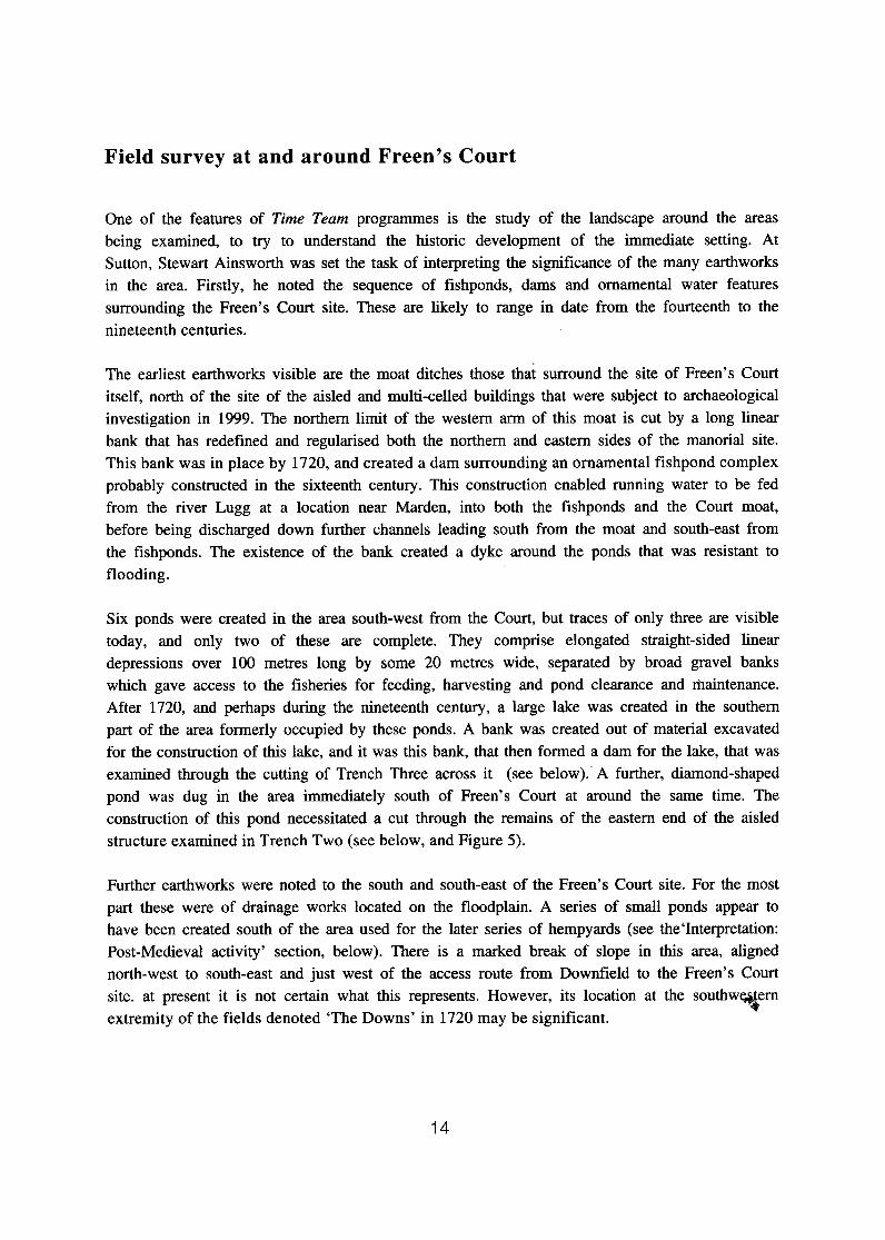
Trench Three (see Figures 5 and 6) was located across the bank ikferred to above, separating the former lake from the higher area to the east containing the remains revealed in the parch marks. The excavation showed the high-resistance feature within the bank to be a spread of gravel-rich soil used to cap the earthwork. The finds contained within the bank comprised a mixed and probably redeposited assemblage including post-medieval pottery comprising utility wares and ceramics imported from northern France and southern Spain. The nineteenth century date of the most recent among the finds was taken to date the construction of the bank, which was accordingly confirmed in its identity as a dam built to create one of the later ponds.
Trench One, sited to examine one of the walls of the multi-celled building, located this after the removal of a thin dumped deposit below the topsoil. The upper deposits here contained structural debris, including three fragments of Malvern Chase medieval glazed ware ridge tile. These tiles had most probably once formed part of the roofing of one of the medieval buildings at the site. It was after surface cleaning of this upper deposit that a decision was made to proceed, at least initially, with the excavation of only the southern (if larger) half of the area from which the turf had been removed within the trench.
Following removal of the upper rubble deposit in Trench One, the top of the anticipated wall was revealed. This wall was soon shown to be of roughly coursed construction with facing stones and a rubble core, and bonded with clay (Figure 7). There were no indications of a mortar mix that had leached out. Within the building (that is, towards the eastern end of the trench), a stiff red clay deposit had been used to level up the ground roughly to the top of the surviving courses of the wall. This deposit contained a small mixed assemblage of medieval and post-medieval wares. Beneath this and still within the building a green-brown clay-silt deposit was uncovered and excavated. It was unclear whether this deposit was a further fill within the building, or a levelling deposit for its floor. It contained sherds of late eleventh or early twelfth century date including a fragment from a Worcester sandy ware jar and others from Malvern Chase coarseware jars.
Roughly three courses of the wall were observed standing within Trench One. These and the foundation courses were left in situ (Figure 8). The courses comprised alternating ban Qf cut blocks and laid slabs. No foundation cut was found for the wall, despite revealing the foundation courses on both sides, within the southern half of the trench. A deposit of stones uncovered and excavated at the western end of the trench is thought to represent a near-contemporary demolition deposit (see Figure 9). The stones removed within the trench filled the eastern edge of an
apparent east-west rubble-filled ditch. These stones differed markedly in character from those in the coursed wall. They were rounded boulders rather than quarried and roughly dressed stones, and had been retrieved from river banks or drift deposits. Lumps and traces of mortar were found mixed in with the rubble. (For relation of the two features, see Figures 9 and 10).
Figure 5. Trench Three, 15th October 1999, viewed.from the south-west.
Figure 6: Plan and section o f Trench Three.
16
Gravel Path
. - . - . - . - . .W. - .
I .
- -La-' ..*
10' ;*;..:; - m-.;.; .?,*I D' .. . 0'1
, .;.. . .. o ..'. ,;cc-; , . .. . ..' ,-
. 0 ; :...,c Nonh Y:.~:.' .L. ..* L
. d.,.. 2--.we: -.-. A . - 1
0 sm - 4

Figure 7: The top of the wall in Trench One, as revealed afer removal ( superficial dumped deposit, on 12th October 1999. vie we^ north. The scale is in divisions of 0.5 metres.
Figure 8:
,f the i from the
Wall in Trench One, from the west, 13th October 1999. Note quality of build of the external face and the existence beneath foundation courses. Scale divisions are of 0.20m.
the this of the

Figure 9: Trench One from the west, with the top of the demolition deposit in the foreground, 12th October 1999.
Figure 10: Plan and section of Trench One.

The third trench excavated at Freen's Court, Trench Two, was sited over part of the aisled building. This revealed another spread of rubble just beneath the topsoil. However, this rubble layer contained animal bone, brick debris, and modem ceramics as well as stones. It represnts another demolition layer, this time probably of an aisled barn, parts of the foundations of which were revealed at the same level within the trench (Figures 11 and 12). Within this spread also was found the one piece of architectural stonework discovered in 1999. This was part of the reveal of a window or door, with fine tooling probably of twelfth century date. A small sub-circular pad- stone was then uncovered in the trench, fixed firmly within the rubble. To its south was a narrow section of clay-bonded wall perpendicular to and crossing the trench. Together, these appear to have formed part of a late post-medieval aisled barn. To the nqrth, and running at an oblique angle, was a configuration of stones apparently once forming part bf a drain within the barn.
The demolition rubble was then removed over the eastern half of Trench Two, in an operation mirroring that performed in Trench One. Medieval pottery of fourteenth century date and local manufacture was found within layer below the rubble, and this is considered to be a levelling layer contemporary with another stone post-pad sealed beneath the rubble and within the lower matrix. A clay-bonded stone wall entering the trench at an angle at its southern limit (and according closely to the structure visible here on the AML geophysical survey) may belong to the same build horizon. Yet another aisled barn is presumed to be represented by the lower of the two post- pads.
Beneath the later medieval levelling layer in Trench Two was found a silty deposit across which was found an ashy deposit. Towards the northern end of the trench this deposit became thicker and more carbonised. A large assemblage of broken pottery was found in among the burnt pieces of wood, crushed timbers and building debris from within this deposit (see Figure 13). One group of finds from this deposit relates to the building which this is the destruction deposit for, and derives from the debris resulting from the fire that burned it down. Apart from timbers turned to charcoal, other items of this kind included pieces of clay daub collapsed from panels set in a timber frame located high up in the superstructure. These pieces had burned at high temperatures to a brick-like consistency. Also found were fragments of stone roof tiles that had burned and had become shattered before falling into the centre of the building, and were found lying where they had fallen in what had been a central drain (Figure 14). The deposit included the fully carbonised remains of whole structural elements. This included a series of planks seen only in section. these were initially thought to have formed part of a plank floor raised on a joist. The possibility also exists however that they were part of a stall or some other internal partition within the building (Figure 15).
Another group of finds from this deposit comprises remains of things that were inside the building when it burned down. From the pottery finds and radiocarbon samples taken from wood and grain, this event can be dated to between 1150 and 1200AD. These 'storage' finds included charred grain, bone from a large ungulate (probably a cow), and the many pieces of broken pottery. The size of some of the sherds suggests that whole vessels had been standing within the building at the time of the conflagration, and were crushed by the collapsing superstructure.

Figure 11: Trench Two from the south-east, on 12th October 1999. The rubble surface has been cleaned and is being planned.
Figure 12: PMn of Trench Two showing the nature of the rubble spread and the relative position of the later features revealed in the excavation.
20

Figure 13: The northern end of Trench Two on 14th October 1999. The top of the ashy deposit is revealed on the right of this view from the west, and this is seen as lighter and more carbonised bands in section at the north- eastern corner of the trench. To the left also, the top of the most heavily-carbonised deposit is visible. Scales are in 0.20 metre divisions.
Figure 14: The northern end of Trench Two, 15th October 1999, from the south. The lower burned deposit. has been part-sectioned to reveal the drain at t he centre of the building. Scales are in 0.20 metre divisions.

Figure 15. North-eastern corner of Trench Two, 15th October 1999. Closest to the scale is a fully-carbonised rectangular-sectioned timber rail, probably in oak. Next to this, successively, are three planks each of around 0.30 metres in length bv 0.05 metres in width, laid or-fixed side by side.
The final feature to be noted among those excavated in Trench Two was one that was first revealed as a stone-packed hole set within the lower silty matrix at the centre of the trench. This measured 1.8 metres east-west by 1.2 metres north-south, and comprised several levels of build. The upper deposit, some 0.50 metres deep, was a void into which stones had been loosely packed. Beneath this was a build level at which a flat surface had been created from closely-fitted stones of varied size (Figure 16). Beneath this was another deposit comprising tightly packed stone, terminating at another possible build level some 0.50 metres below the upper one. Further tightly- packed stones were revealed to a total depth of just over two metres below the point at which the packed stones had been revealed as a surface feature (see Figure 17). At this point, the stone-filled feature was based upon the natural gravel underlying the silty deposits. The relation of this deposit to the layers containing medieval pottery is uncertain. It was overlain by the levelling deposit with fourteenth century pottery, and must have been earlier in construction date than this. It may have been contemporary with or earlier than the deposit containing twelfth century material, and could have formed a pier-base.
This stone-packed feature was shown by Bernard Thomason to have been the site of one of the series of circular parchmarks seen on the 1990 aerial photographs. It would seem that, structurally, this stone-packed feature (referred to as a post-pad in Figure 17) is to be linked with the drain filled with burnt material at the northern end of the trench and at the centre of the aisled building. This structure therefore had a span for the central aisle of some twelve metres, and a likely total width of over twenty-five metres. There are, moreover, indications on the ground that its total length may have been as much as sixty metres.
77

Figure 16: Stone-packed feature revealed in Trench Two, 14th October 1999, from the east. The scale, with divisions of 0.20 metres, has been placed on t the upper, and best -de$ned build surface.
n as parch mark
Drain
--- I, I
Figure 17: Plan of Trench Two, showing relative locations of the earlier features.

Field suivey around Sutton St. Michael Church
One of the sites examined at an early stage in the preparations for the project was St.Michael's Church. This features blocked windows of late Saxon, or more probably of early Norman date. A fragment of a decorated capital of similar date is to be observed re-used in the exterior of the south wall of the nave. The church is remarkably similar in form to that at Sutton St. Nicholas, having a simple two-celled plan. St Michael's Church was apparently once graced with the same style of west tower that remains at St. Nicholas, to judge from a blocked two-centred arch in the west wall of the nave. t
s ~ 4 . 10% The character of the earthworks in a smdl field to the west of the church has been questioned for some time, since they do not resolve themselves easily into the platforms and holow-ways normally associated with a deserted medieval village. During the five days of the 1999 season, closer examination of the fields south of the church produced some surprises. It is now evident that two massive north-south ditches 'frame' a huge enclosure east and west, with the churchyard occupying a north-central position within it. The ditch forming the western boundary runs along the western margin of the 'deserted village' field. This ditch curves outwards towards its centre (see Figure l), a course obscured by the present-day siting of a hedge along its western margin.
The other ditch, forming the eastern boundary, curves in a manner that mirrors the western one. The eastern of these great ditches crosses a pasture paddock, and both ditches run from the Marden to Sutton road down to the floodplain of the Lugg. In both cases the ditches remain massive earthworks in today's landscape. Indeed, it is this scale, in profile extending to a depth of over three metres from east to west across each of them, that has inhibited their recognition as historic features up until the present day.
The enclosure defined here is termed the 'great enclosure' to distinguish it from the further ditched enclosures that have been observed as existing within it. These latter earthworks are, in plan, perpendicular to the boundaries of the greater enclosure and appear to have been planned integrally within it. They contain further embanked features, level areas and platforms, which may represent the locations of structures of a variety of kinds.
Excavations at Downs East
The first of two excavations at the Downs East site, the paddock to the south of Over Court, was a trench (Trench Five) dug using a mechanical excavator across the base of the more easterly of the ditches framing the 'great enclosure'. Beneath the turf, recent silt infil deposits extended to a depth of just under a metre. Below this a clay-silt deposit was encountered, representing earlier phases of fill of the ditch, and extending a further 0.5 metres to the original cut.

From both of these infil deposits a small assemblage of animal bone from domestic stock was retrieved. The circumstances of retrieval were not ideal, although the separation out of material from the lower deposit was attended to carefully. The base of the ditch contained a lens of gravel, presumably derived from upslope.' From close to this deposit came the only artefact retrieved from Trench Five. This was a small iron object that was identified as a stake, or small anvil used mounted in a wooden block for close work with fine metals.
This massive ditch can be shown to have had a profile as originally dug, some thirty metres wide, 3 6 wide and five metres deep. A significant factor here is also a substantial gradient along the course of the ditch, from north to south. This may account for the gravel deposit, and has prevented substantial silting from occurring.
Close ground observation during the 1999 season resulted in the detection of the presence of further ditched enclosure with an east-west extent of over a hundred metres, in the north-east corner of the enclosure. Geophysical survey across this area within the Downs East field 305''t.
confirmed the presence of the ditch even where not obvious at ground level. The survey also showed the presence of rectilinear features within this smaller enclosure. A provisional interpretation of these anomalies suggested that they might represent in part the stone foundations
I of further buried buildings.
A small (four by two metre) trial excavation was therefore carried out within the inner ditched enclosure (Trench Six). This revealed that 0.40 metres of topsoil had formed over the original ground-surface. A single feature was located here, clearly sealed by the fine silty loam that represnted a soil profile developed over a considerable length of time here. A single very abraded and undoubtedly residual sherd of Severn Valley ware Romano-British pottery came from the upper deposit. The feature was a gravel-filled ditch aligned east and west. No finds of any medieval ceramics were made in the trench.
Figure 18: Profile of the enclosure ditch sectioned by Trench Five, on 13th October 1999, from the north-west. Scale in 0.20 metre divisions

i . . - - - A 1 1 - 1
Figure 19. Ditch in Trench Six, as profiled on 13th October 1999, from the west Scale in 0.20 metre divisions . The gravel infil of the feature that appeared to indicate the presence of a wall or similar structure is clearly visible.
l 1 Tmch 5
E& Bank
Gravel
1 Trench 6
Figure 20: North-facing section of Trench Five and west-facing section of Trench Six, at the Downs East site. The cut for the ditch in Trench Five marks the base o f the much wider feature.
Post-excavation analyses
Analyses are continuing into the finds and samples retrieved from the excavations. These studies have included identification of wood and seed samples, ceramics, and animal bone. They have also encompassed microscopic examination of the iron stake from Downs East, and radiocarbon dating of a series of samples from three different contexts within two of the trenches.
The fullest identifications so far available are those for the pottery p ~ d ceramic building materials from the site, examined by Dr. Alan Vince. Besides four abraded sherds of Romano-British Severn Valley ware that represent a background scatter of residual material, there were ninety-one sherds of medieval pottery. Sherds from vessels of ten different wares are represented within this assemblage, all of which fall within the range of material of eleventh to fifteenth century date known from Hereford.
Among the earliest of these medieval ceramics were two sherds of Vale of Gloucester coarseware, from trenches Two and Four. The date range for this fabric is approximately 1050 to 1250, but in a Herefordshire context an earlier date is thought more likely. A sherd of Worcester sandy ware, from a collared rim cooking pot, from Trench One is also considered indicative of an early date, c.1100. The largest number of potsherds came from the burnt deposit in Trench Two. Although some vessels in local Herefordshire wares were preesent, the pottery from inside the destroyed building was primarily from Malvern Chase, and took the form of pots or jars of the early coarsewares.
Analysis of the flots from the sieved samples from the burned deposit in Trench Two has indicated that although badly burned and distorted in the conflagration, the grains retrieved are from bread wheat that had been harvested and stored but not yet threshed. The wood of the planks sampled from the same deposit indicated something of the nature of the disruption caused by the catastrophic fire that consumed the building. Wood analysis showed that the oak of the planks had become almost entirely reduced to ash, and had become mixed in the fire with wheat grains, other carbonised seeds, and pieces of willow or poplar, perhaps from baskets, woven panels, or tool handles. Analysis of animal bone samples from a small number of the Sutton site contexts is in progress, but reporting will await further analysis following the 2000 season of fieldwork.
Six radiocarbon dates were obtained from samples drawn from three contexts. The analysis was 7 carried out at the Oxford University Accelerator Unit early in 2000, and confirms e& second milennium dates from pig bone from the Downs East (Trench Five) ditch, and from the planks and grain from the burnt deposit in Trench Two. This latter was a split sample, and one date returned a possible late first millennium date. The dates will be published in full in a subsequent report.
Interpretation: Post-Medieval activity
By the time of the 1720 Coningsby plan of Marden, the site at the Downfield Knoll was used as a hemp-drying yard, the first stage in the processing of the crop on its way to being made into rope. By the 1840s, the knoll was a hopyard, and later it became an orchard. It is not impossible that the double-ditched enclosure, with its construction cuts high up the soil profile, could have been used in connection with the hemp-drying process. Meanwhile, the hempyard itself had been moved southwards, to a location just east of Freen's Court itself., Freen's Court was tenanted and largely contained within the medieval moat. The sixteenth cepnu)' had witnessed a major phase of building, the prosperity of the manor under the fourth Sir John Lingen being attested by the number of properties left to his daughter Jane on his death in 1554. It is also now attested in the ceramic record from the Freen's Court excavations within Trench Three, that includes the presence of the exotic (for Herefordshire) Spanish 'Columbia Plain Ware' bowl from Seville, dated to the period 1500-1550.
By the 1720s, almost the whole surroundings of the Court, including the later hempyard, were down to orchard. This is itself a reflection of the decline in the fortunes of the Lingen family in the seventeenth century. The site of the earlier ornamental fishery features is represented by rectangular hollows, shown covered like the rest of the surroundings in orchard trees, and labelled 'The Moats'. North-west of the Court is depicted a large rectangular enclosure labelled 'Brick Close'. This represents a large walled paddock that in the sixteenth or seventeenth century might have contained a formal garden.
South of Freen's Court itself, the site of the aisled and multi-celled buildings is shown as occupied in part by two structures. The first is a square - and probably half-timbered - dovecot (marked 'pigeon-house'), located close to the site on the site of the earlier aisled building and later medieval barn. The other structure is a building that also occupies a site close to the moat, and south a small bridge across it near its southwestern angle. This structure is shown as being of considerably smaller proportions to the multi-celled building, but sharing its alignment. Perhaps this is yet another barn, filling a gap in the sequence here? Close to the dovecot was located an aisled barn built presumably after 1720, to judge both from the Coningsby plan and the demolition rubble encoutered in Trench Two. Both an aisle wall and a stone-lined drain are interpreted as being contemporary with the pad-stone of this barn also found in this trench.
The Coningsby plan also illustrates the relative isolation, even then, of St. Michael's Church. As until very reckntly, its only neighbours were Over Court and Ordis Court, two farms likely to have been of medieval date. The names themselves may be significant, not as indicative of any manorial link, but rather in reference to the 'court' as the enclosure within the north-east corner of which the former stands. The fields that today contain the earthworks of the'great enclosure' were in 1720 simply meadows. Excavation suggests had this had been the case for a long time.

Interpretation: Medieval phases
In the later medieval period, it is uncertain what became of the site of the structure (or structures) located in the 1999 excavations at Downfield Knoll. It is possible that they were replaced by the double-ditched rectangular enclosure, but as has already been noted, a post-medieval date for this is equally plausible on the evidence available to us at present.
The exact nature of the structure that was dismantled here sometime between the mid-eleventh and late twelfth century is also unclear. The feature excavated is b;!t interpreted, if provisionally, as a foundation-slot for a standing structure in timber. The bi-lobed cut at its northern extremity is suggestive of the presence here of two circular posts set side by side, perhaps each with one side dressed flush with the side of the foundation trench. The linear slot was traced during the excavation southwards, terminating within the excavated area, but its southern terminus was not-
\08r+. excavated. This 'structure' might then have been part of a near-continuous palisade running down the hill from the knoll, since a further slot is indicated southwards on the same aerial photograph that showed the excavated slot.
The latest dateable medieval structure examined at the Freen's Court was the aisled barn, one post-pad of which was revealed during the excavation within Trench Two. This was probably in place by the fourteenth century, to judge from the material from what has been interpreted as the levelling layer for its floor. No contemporary aisle wall for this structure was visible within the trench excavated in 1999. However, the clay-bonded stone wall entering the trench at an angle at its southern limit (and according closely to the strcuture visible here on the AML geophysical survey) may belong to the same build horizon.
The clay-bonded wall revealed more substantially in Trench One formed part of the west wall of the central cell of the structure visible on the aerial and geophysical surveys. The gleying of the soil deposits next to this wall has meant that no cut for its construction is now visible, despite there having been three foundation courses which must have been set in a trench. Rather than arguing for a date in the late Anglo-Saxon period for this building, it is simpler to suggest that the twelfth century pottery found close to it, and from beneath post-medieval levelling layers, actually dates the structure. Its careful build indicates a high-status building. In light of the interpretation we now favour for the early Freen's Court complex as an administrative centre for the royal estate, the structure may well have formed a residence and office for the king's reeve. By the twelfth century, whatever its origins, the aisled building examined in Trench Two was being used as a store-house for grain and other goods. Such a use is fully consonant with the administarative centre idea.
Interpretation: Anglo-Saxon origins
By the time of Domesday, Marden was probably part of the district of Maund that in turn was an extensive multiple estate that occupied most of the area of Thornlaw Hundred. It had been in existence as such since at least the late seventh century, and may have been an early royal holding of the Anglian dynasty that ruled the area until it was absorbed into Mercia.
There is as yet no evidence from the Freen's Court site that it ,was occupied during the Saxon period, except perhaps for the late Saxon date (to be published :in due course) drawn from the split sample from grain from the burned deposit within the aisled building. However, the inferred existence of a stone structure (or structures) that preceded the multi-celled building on the site indicates the possibility that there was an important complex here of at least late Saxon date. The questions which then presents itself is exactly what form this complex took.
One possibility that needs still to be considered is that the scale and quality of the aisled building, and a likely association with mortared stone structures, points not only to a middle Saxon date, but also to a direct link with royal facilities. An interpretation of the conjoined timber planking as part of a raised wooden floor (albeit one renewed in the twelfth century), together with an appreciation of the load-bearing capacities of the stone foundations for the aisle-piers, might lead us to an interpretation of the structure as a major hall. This would have served as a reception-hall and mead-hall, as depicted in the poem Beowulf. The location of such a facility (with the other buildings perhaps serving as guest accommodation) by the river could be explained in terms of its possible proximity to water-bourne and road transport to Hereford and down the Wye. Against this idea are the limited archaeological evidenc3, and doubts as to whether such a structure would indeed be placed in so inconspicuous a position.
Both its scale, and the nature of the structure as an aisled building, raise another possibility. This is that, with a span of some twelve metres between the piers, and an approximate east-west orientation, the structure concerned might be a church. Here again, the location would be significant: could not this have been deliberately constructed over the site of the martyrdom? A church of this scale would have been quite contrary to contemporary Anglo-Saxon practice, at least for a non-cathedral context, however.
An altogether different, and more prosaic, interpretation of the structure may be more appropriate, however. Here, the evidence for storage of agricultural produce in the aisled building by the twelfth century, together with the possibility that the planking formed part of a stalled division of the structure suggests that it may instead have been a barn. Although more prosaic, such an interpretation still has important implications. This is at least because the huge proportions of such a barn implies estate management on a massive scale.
Even were the aisled building to have originated only in the twelfth century, the scale of the barn is at the very upper limit of the scale for such buildings at the time. Moreover, the fine

construction techniques of the wall revealed in Trench One indicate that the multi-celled building was a high-status structure. Again, its considerable size, at over sixty metres in total length, reinforces this impression. Another factor that should not be overlooked in assessing the significance of the complex is that-the range of pottery present. This includes products from the Vale of Gloucester, from Worcester and from Malvern Chase (alongside those from local Hereford) potteries, all of which were operating before the twelth century. This suggests both high status, and a close tie with Hereford, in close accord with the documented history.
The interim interpretation for the complex that is favoured here, therefore, is that it formed an administrative centre for the Marden estate, and that this was located at Freen's Court precisely because this was the most accessible point to Hereford, but within the larger Marden estate,
L
throughout this early period. The link to grain storage is perhaps lent an added significance from a reference at the very beginning of the Herefordshire Domesday, in the list of customs of the county. In the third paragraph, it states: .''Within the city wall, (the occupants of) each whole dwelling ... on three days in August reaped at Marden".
A detailed interpretation of the findings from the Downs East site by St, Michael's Church is probably premature. The ditch across which a section was cut, is, along with its more westerly counterpart, currently identified as part of a roughly square 'great enclosure'. The northern side of this enclosure would be followed by the modern road from Sutton to Marden. This road would therefore occupy the site of a hollow-way that in turn would have followed the line of the enclosure ditch here. The southern side of the enclosure was marked by the edge of the floodplain of the Lugg.
Within the massive perimeter ditches were apparently located a variety of other structures and features. Within the northeastern corner of the 'great enclosure' was situated a large area defined to the south and west by less substantial, but still visible, ditches. This further enclosed area was that occupied by the Over Court farm. The ditched area here was itself divided into an upper and lower platformed area. Within at least the lower part of the site, further areas were defined by yet smaller ditches. In the pasture field immediately west of the church there are yet further platforms and more subtle earthwork features. These have been Scheduled as an Ancient Monument, described in this case as the earthworks to the presumed medieval village of Sutton St. Michael.
At present it is both the scale and the complexity of the earthworks at the 'great enclosure' site that suggest an association with Offa and a royal palace. The discovery of the metalworking 'stake' within the eastern ditch, and the total absence (so far) of any medieval pottery from the site, support such an identification. On the other hand, the radiocarbon determinations taken from a sample of the animal bone found in the ditch fill would appear to suggest a possible medieval date for its infilling, if not necessarily its original construction.

Conclusions and prospects
The first of two exploratory seasons of archaeological fieldwork at Sutton St. Michael has enabled the drawing, provisionally, of a series of conclusions about the locality and its history from the middle Saxon period through to the nineteenth century. Primary among these are:
1. The 'great enclosure', a small part of the interior of which is occupied by St. Michael's Church, is of a scale and complexity indicative of the presence here of a centre consonant with a royal 'vill' (palace) site of middle Saxon date.
t
2. This enclosure (which may nonetheless have been fhe pivotal site) is likely to have been but one of a series of locations within the landscape at Sutton which together comprised the royal centre. These locations may have included both the Freen's Court and the Downfield Knoll sites examined in 1999, as well as the possible Marden enclosure and the potentially refortified Sutton Walls camp.
3. Other sites, for instance that at Thinghill, may have formed part of a yet more extensive landscape of localities of importance to the Mercian royal family within the district of Maund.
4. An apparent 'five-sided enclosure', noted from the air as existing at Freen's Court, is largely illusory. It represents the variable survival of a series of embankments designed to channel water into and around the earthworks created next to Freen's Court from the medieval period onwards.
5 . The 'multi-celled structure' identified as outlined in parchmarks in 1990 at Freen's Court is of likely twelfth century date. No traces of an earlier timber structure of similar form were found in the 1999 investigations. It is likely therefore that its resemblance in plan to middle Saxon halls elsewhere is quite fortuitous. What this Norman period building was used for is as yet uncertain.
6. Nonetheless, it seems at least possible that this building replaced an earlier structure or structures close by, inferentially of Saxon date.
7. The aisled building also visible in parchmarks was a massively-built structure as yet of unknown original construction date, or purpose, or development.
8. By the twelfth century this structure was roofed at least in part by stone tiles, and had a superstructure that in part at least comprised timber framing with wattle and daub panelling. The building was fitted with a floor, or partitions, of stout wooden construction, and was used for the storage of freshly harvested grain (and probably of other goods as well, kept in a variety of containers).
9. The aisled structure was destroyed in a massive fire late in the twelfth century. By the fourteenth century it had been rebuilt as a barn, and on a smaller scale.
10. Although possibly in origin an Anglo-Saxon hall, an present evidence it seems more plausible to regard the whole of this early complex at Freen's Court as a farm administive centre for the royal (and later ecclesiatical) estate of ' Sutton-cum-Marden' .

The prospects are more difficult to specify with certainty. There is an intention to examine the sites explored in 1999 in a further brief series of investigations in June 2000. It is intended that the 2000 season will feature further (but still limited) examination of the Freen's Court site, probably concentrating on the features located by the AM Laboaratory geophysical survey immediately to the west of the multi-celled building.
Slightly more extensive excavations within the 'great enclosure' around Sutton St. Michael Church, following completion of topographical and geophyical survey. It is intended that such surveys will enable close targetting of test excavations that may take place in the area of earthworks west of the church. In the 'Downs East' area south of the church, excavations are planned within the enclosure noted in 1999, and southwards in thy south-eastern corner of the 'great enclosure'. i
Such further trial investigations will not be the end of the story. They will lead to further post- excavation analysis and archiving, and to a full publication of the results of the 1999-2000 fieldwork. It is then intended that such documentation will provide the foundation for a University-based research investigation of the Freen's Court and Downs East sites, and of the other sites noted briefly below, over a number of years.
These other sites may share a direct link with the sites investigated in 1999 and 2000, but will not be subject to further investigation at this stage. Only a very. summary reference can be made to these sites here. The first is the site implied by the 'Heneage' field names. This has been taken to mean, somewhat unproblematically, 'old homestead enclosure'. However, if both elements of the name are identified as Old English (not unlikely given the relative dearth of British placename elements in the neighbourhood), the reference can be understood instead as to 'the near enclosure', as Sheppard was careful to point out. This enclosure is not, as recently stated by Jean O'Donnell, the site of the parchmarks investigated in 1999, but is close to it, westwards of the Freen's Court manorial site.
What such alternative identification raises however, is another question, as to what the 'near enclosure' is near to. The answer potentially lies in three sources of information. The first source is again a place-name, this time of Marden itself. Both Sheppard and Copplestone-Crow agree that this means 'Magene enclosure'. (Here, a contrast exists between a 'haie' or hedged stock-proof enclosure, and a 'worthign', or settlement enclosure). There are hints on the ground that just such an enclosure may exist around the bluff of land south of Marden church, above the river Lugg. The second source is the discovery of an object here in the nineteenth century. It was from this area next to church that the massive bronzed iron ecclesiastical bell of tenth or eleventh century date now at Hereford Museum was found in 1848. The field on the site of the enclosure was known in 1720 as 'The Bell Field', and it was perhaps here that the bell was set up and rung.
The third source is again an historical tradition recorded by Giraldus Cambrensis. In Chapter Four of the Life, Gerald says that three nights after the murder Aethelbert appeared in a vision to Brichfridus ('a very rich man'), 'in the silence of the night'. Aethelbert commanded that Brichfridus should 'recover and dig out' his body from a named place 'near a monastery situated in the same place'. It is clear from the narrative sequence that this was before the journey

to Hereford via Lyde and Shelwick, so was this location the place that later tradition identifies as the site where a well sprang up where Aethelbert's head was found, namely at Marden? The combination of place-name, topography and possible earthwork, ecclesiatical bell find, and recorded tradition certainly seems to point in this direction.
The second site is that of the King's Mill, located at the point where the present road to Moreton crosses the Lugg. Both the 1720 Coningsby plan and the Tithe Award map locate this from the name given to the adjacent meadow on the Marden side of the river. The third site is that of the royal defensive enclosure or burh at Sutton Walls, which we have already suggested might have been within the great Iron Age fort with its remarkably high, and perhaps enhanced, defences.
The final site in this group is at Thinghill near Withington. Thi$ is a prominent flat-topped hill which from its Anglo-Saxon place-name meaning 'place of assembly', would seem to be an appropriate site for the moot of the of Thornlaw Hundred. A recent field visit to the site has indicated that the hill may feature more than simple topographical prominence and a suggestive name. On the top of the hill until recent years stood a mansion surrounded by ornamental trees, but this has since been demolished. however, to the north side, and facing in towards the former Hundred, there is a massive artificially-scarped terrace. To judge from the hedge on its northern side, this is some antiquity. It seems at least possible that this was the site of the Hundred moot itself, with the assembly able to occupy what in effect is banked seating set above a level speaking, or judgement, area.
The reason for such interest in this area is founded not only in 'the search for King Offa's palace' which created the headline both for the Time Team programme and for the special'arts and archaeology' event organised in association with Hereford Museum and the musical group Arcady at the Courtyard Theatre in March 2000. It seems likely that the Marden area assumed political and strategic importance within Herefordshire not long after the founding of the local Anglian dynasty in the area of the historic county in the seventh century. Moreover, it now seems likely also, that the sites in this area may hold vital clues to the operation of social and institutional processes in the transitional period between late Anglo-Saxon Mercia and the time of the emergence of the Marcher lordships in the twelfth century.
References Bruce Coppleston-Crow, 1989, Herefordshire Place-Names. Jean O'Donnell, 1996, 'Two Field-Names In The royal Manor of Marden' , TWNFC, XLVIII Pt.111. June A. Sheppard, c.1969, The origins and evolution offield and settlement patterns in the Herefordshire manor of Marden.
Acknowledgements
Our first acknowledgments and thanks go to the landowners: Dudley, Miles, and Margaret Price of Marden, and Peter and Nicola Harper of Sutton. Their friendly co-operation has made both the fieldwork and this Interim Statement possible. Staff of English Heritage, Dr. Paul Stamper, Lisa Moffat, Stewart Ainsworth and Bernard Thomason both facilitated and participated in the fieldwork.
Thanks are due also to Tim Taylor, Philip Clarke, Mick Aston, Jqremy Cross, and Videotext Productions in association with Picture House. Regular Time Team3members Phi1 Harding and Carenza Lewis, together with the geophysics team from GSB Prospection, Bradford, led by Chris GafSney and John Gater, were a considerable asset during the making of the programme. Besides the film crew, research and liaison work by Jenni Butterworth, Pippa Gilbert and Ella Galinski was much appreciated, as was the help on site of Katy Hirst, Mick Worthington and Caroline Barker of the regular Time Team digging team. This team was supplemented at Sutton in 1999 by the expertise of Jeremy Haslam, Erica Hemming, Curly Jones, Elizabeth Pearson (environmental sampling and analysis), and Steve Yeates, to all of whom we also extend our sincere thanks.
For Herefordshire Council, fieldwork was co-ordinated with assistance from Rebecca Roseff and Julian Cotton of Herefordshire Archaeology. Extra help on site was provided by Sites and Monuments Record volunteers Andrew Burgess, Angela Currie, Joan Featherstone, Marge Feryock, Roy Gough, Chris High, Barbara Joss and Tony Reeve, to each of whom we wish to express our gratitude. Special thanks are due also to Alexandra Millward and Paul Gibbons, again of the Conservation and Environmental Planning section of Planning Services, for help with photography and architectural interpretation, respectively.
Judy Stevenson of Hereford Museum co-ordinated the involvement of stafffrom Herefordshire Council Heritage Services at all stages. Our thanks to her are also conveyed to Siriol Collins, Claudia Hart, Althea McKenzie, Sarah Skelton and Peter Young for their varied contributions to the project. Rachel Curran, of the press and publicity staff of Herefordshire Council, is thanked for co-ordination of public relations work before and during the fieldwork.
Finally, the authors of this Statement would like to record their thanks to their research collaborators, Dr. Umberto Albarella, Dr. Chris Arnold, Dr. John Blair, Dr. John Eisel , Dr. Alan Vince, and Dr. David Whitehead. It is in no small measure due to their past and continuing enthusiasm and support for the project that it has been possible to initiate and to sustain the work reported here.