Embed Size (px)
Citation preview
GEOLOGICAL SURVEY OF NEW JERSEYHENRY B. KÜMMEL, STATE GEOLOGIST
BULLETIN 6.
Annual Administrative ReportOF THE
STATE GEOLOGISTFor the Year 1911
INCLUDING A REPORT ON
SHARK RIVER INLETBy C. C. Vermeule, Consulting Engineer
TRENTON, N. J.MacCrellish & Quigley, Printers, Opposite Post Office.
1912.
NEW JERSEY GEOLOGICAL SURVEY

NEW JERSEY GEOLOGICAL SURVEY
The Geological Survey of New Jersey.
BOARD OF MANAGERS.
HIS EXCELLENCY WOODROW WILSON, Governor and ex officio Presi-
dent of the Board,...................................................Trenton
Members at Large.HARRISON VAN DUYNE, ........................................... Newark, ................................ 1912JOHN C. SMOCK,........................................................ Trenton,.................................. 1913ALFRED A. WOODHULL,................................................Princeton, .............................. 1914FRANK VANDERPOEL, .................................................Orange, .................................. 1914T. FRANK APPLEBY, ....................................................Asbury Park, .......................... 1915DAVID E. TITSWORTH,................................................Plainfield,................................ 1916WILLIAM LIBBEY, ........................................................Princeton, ............................... 1916
Congressional Districts.
I. STEPHEN PFEIL, ...............................................Camden, ................................. 1916II. P. KENNEDY REEVES, ..................................... Bridgeton, .............................. 1912
III. HENRY S. WASHINGTON, ............................. Locust, ................................... 1914IV. WASHINGTON A. ROEBLING, ......................... Trenton, .................................. 1913V. FREDERICK A. CANFIELD, ............................... Dover, .................................... 1915
VI. GEORGE W. WHEELER, .................................... Hackensack, ........................... 1916VII. HERBERT M. LLOYD, ....................................... Montclair, .............................. 1912
VII I. E. H. DUTCHER, ........................................... East Orange, ......................... 1914IX. JOSEPH D. BEDLE, ....................................... Jersey City, ........................... 1913X. CLARENCE G. MEEKS,...................................... Weehawken, .......................... 1915
State Geologist,
HENRY B. KÜMMEL.
(3)
NEW JERSEY GEOLOGICAL SURVEY

NEW JERSEY GEOLOGICAL SURVEY
Letter of Transmittal.
TR E N T O N, N. J . , February 13, 1912.Hon. Woodrow Wilson, Governor, and ex officio President o f
the Board of Managers of the Geological Survey:SIR--I have the honor to submit by Administrative Report
summarizing the work of the Geogological for the year 1911.
This report is made in accordance with Chapter 46 of the Lawsof 1911. Later in the year I shall submit, for publication,scientific bulletins giving in detail the results of the Survey'sinvestigations. Yours respectfully,
HENRY B. KÜMMEL,State Geologist.
(5)
NEW JERSEY GEOLOGICAL SURVEY

NEW JERSEY GEOLOGICAL SURVEY
Administrative Report.
H E N R Y B. K Ü M M E L, S T A T E G E O L O G I S T .
Contents.Administration. Expenditures.
Organization.Publications.Distribution.Library.Property records.Note taking.
Topographic Work. Leveling.Geologic Work.
Plant remains of the Raritan Clays.Fish remains of the Cretaceous and Tertiary formations.Mineral production.Well records.Wells at State Institutions.Report to the Managers of the Women's Reformatory.Coastal stability vs. Coastal subsidence.Green Pond Mountain Belt.
Soil Investigations.Field work.Analysis of soils.
Testing Oil and Bitumen for Road Making.Co-operative work.Meetings and Conventions.
Association of State Geologists.American Mining Congress.Mine Safety Demonstration Meeting.
Report on Improvement of Shark River Inlet.
ADMINISTRATION.
The lines of work prosecuted by the State Geological Surveydo not differ greatly from year to year, so that there is littleopportunity for anything new in the Annual AdministrativeReport which the State Geologist is by custom and by law re-
(7)NEW JERSEY GEOLOGICAL SURVEY
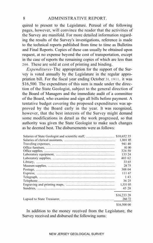
8 ADMINISTRATIVE REPORT.quired to present to the Legislature. Perusal of the followingpages, however, will convince the reader that the activities ofthe Survey are manifold. For more detailed information regard-ing the results of the Survey's investigations, reference is madeto the technical reports published from time to time as Bulletinsand Final Reports. Copies of these can usually be obtained uponrequest, at no expense beyond the cost of transportation, exceptin the case of reports the remaining copies of which are less than2 00 . These are sold at cost of printing and binding.Expenditures-The appropriation for the support of the Sur-
vey is voted annually by the Legislature in the regular appro-priation bill. For the fiscal year ending October 31, 1 9 11 , it was$16,500. The expenditure of this sum is made under the direc-tion of the State Geologist, subject to the general direction ofthe Board of Managers and the immediate audit of a committeeof the Board, who examine and sign all bills before payment. Atentative budget covering the proposed expenditures was ap-proved by the Board early in the year. It was recognized,however, that the best interests of the Survey might demandsome modifications in detail as the work progressed, so thatauthority was given the State Geologist to make such changesas he deemed best. The disbursements were as follows:
Salaries of State Geologist and scientific staff, .................................. $10,652 35Salaries of clerical assistants, ............................................................. 1,801 05Traveling expenses, ....................................................................... 941 40Office furniture, .................................................................................. 81 00Office supplies, .................................................................................... 324 50Laboratory equipment, ...................................................................... 133 24Laboratory supplies, ........................................................................... 403 62Library, ......................................................................................... 33 65Museum supplies, ................................................................................. 28 75Postage, .............................................................................................. 308 04Express, .............................................................................................. 111 67Telegraph, .......................................................................................... 1 43Telephone............................................................................................ 36 25Engraving and printing maps, .......................................................... 1,331 05Sundries, ............................................................................................. 45 28
$16,233 28Lapsed to State Treasurer, ......................................................... 266 72
$16,500 00
In addition to the money received from the Legislature, theSurvey received and disbursed the following sums:
NEW JERSEY GEOLOGICAL SURVEY
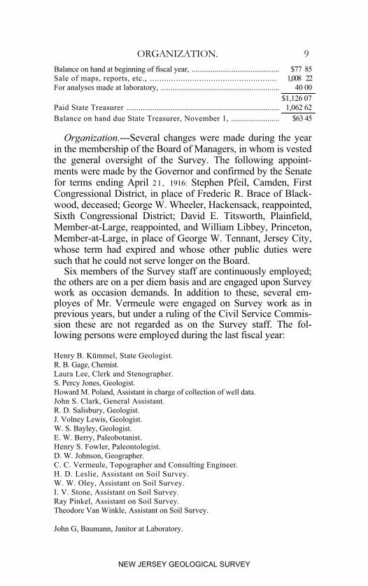
ORGANIZATION. 9Balance on hand at beginning of fiscal year, .............................................. $77 85Sale of maps, reports, etc., ...................................................... 1,008 22For analyses made at laboratory, ........................................................... 40 00
$1,126 07Paid State Treasurer ............................................................................ 1,062 62Balance on hand due State Treasurer, November 1, ........................ $63 45
Organization.---Several changes were made during the yearin the membership of the Board of Managers, in whom is vestedthe general oversight of the Survey. The following appoint-ments were made by the Governor and confirmed by the Senatefor terms ending April 21 , 1916: Stephen Pfeil, Camden, FirstCongressional District, in place of Frederic R. Brace of Black-wood, deceased; George W. Wheeler, Hackensack, reappointed,Sixth Congressional District; David E. Titsworth, Plainfield,Member-at-Large, reappointed, and William Libbey, Princeton,Member-at-Large, in place of George W. Tennant, Jersey City,whose term had expired and whose other public duties weresuch that he could not serve longer on the Board.
Six members of the Survey staff are continuously employed;the others are on a per diem basis and are engaged upon Surveywork as occasion demands. In addition to these, several em-ployes of Mr. Vermeule were engaged on Survey work as inprevious years, but under a ruling of the Civil Service Commis-sion these are not regarded as on the Survey staff. The fol-lowing persons were employed during the last fiscal year:
Henry B. Kümmel, State Geologist.R. B. Gage, Chemist.Laura Lee, Clerk and Stenographer.S. Percy Jones, Geologist.Howard M. Poland, Assistant in charge of collection of well data. John S. Clark, General Assistant. R. D. Salisbury, Geologist.J. Volney Lewis, Geologist. W. S. Bayley, Geologist.E. W. Berry, Paleobotanist.Henry S. Fowler, Paleontologist. D. W. Johnson, Geographer.C. C. Vermeule, Topographer and Consulting Engineer.H. D. Leslie, Assistant on Soil Survey.W. W. Oley, Assistant on Soil Survey. I. V. Stone, Assistant on Soil Survey. Ray Pinkel, Assistant on Soil Survey.Theodore Van Winkle, Assistant on Soil Survey.
John G, Baumann, Janitor at Laboratory.
NEW JERSEY GEOLOGICAL SURVEY
10 ADMINISTRATIVE REPORT.
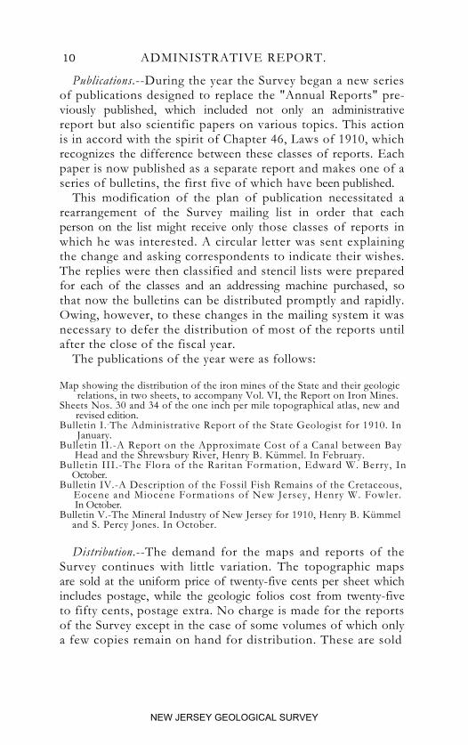
Publications.--During the year the Survey began a new seriesof publications designed to replace the "Annual Reports" pre-viously published, which included not only an administrativereport but also scientific papers on various topics. This actionis in accord with the spirit of Chapter 46, Laws of 1910, whichrecognizes the difference between these classes of reports. Eachpaper is now published as a separate report and makes one of aseries of bulletins, the first five of which have been published.
This modification of the plan of publication necessitated arearrangement of the Survey mailing list in order that eachperson on the list might receive only those classes of reports inwhich he was interested. A circular letter was sent explainingthe change and asking correspondents to indicate their wishes.The replies were then classified and stencil lists were preparedfor each of the classes and an addressing machine purchased, sothat now the bulletins can be distributed promptly and rapidly.Owing, however, to these changes in the mailing system it wasnecessary to defer the distribution of most of the reports untilafter the close of the fiscal year.
The publications of the year were as follows:
Map showing the distribution of the iron mines of the State and their geologic relations, in two sheets, to accompany Vol. VI, the Report on Iron Mines. Sheets Nos. 30 and 34 of the one inch per mile topographical atlas, new and revised edition.Bulletin I.-The Administrative Report of the State Geologist for 1910. In January.Bulletin II.-A Report on the Approximate Cost of a Canal between Bay Head and the Shrewsbury River, Henry B. Kümmel. In February.Bulletin III.-The Flora of the Raritan Formation, Edward W. Berry, In October.Bulletin IV.-A Description of the Fossil Fish Remains of the Cretaceous, Eocene and Miocene Formations of New Jersey, Henry W. Fowler. In October.Bulletin V.-The Mineral Industry of New Jersey for 1910, Henry B. Kümmel and S. Percy Jones. In October.
Distribution.--The demand for the maps and reports of theSurvey continues with little variation. The topographic mapsare sold at the uniform price of twenty-five cents per sheet whichincludes postage, while the geologic folios cost from twenty-fiveto fifty cents, postage extra. No charge is made for the reportsof the Survey except in the case of some volumes of which onlya few copies remain on hand for distribution. These are sold
NEW JERSEY GEOLOGICAL SURVEY
PUBLICATIONS. 11
at cost price. Recipients are requested to pay the cost of trans-portation of certain of the larger volumes.
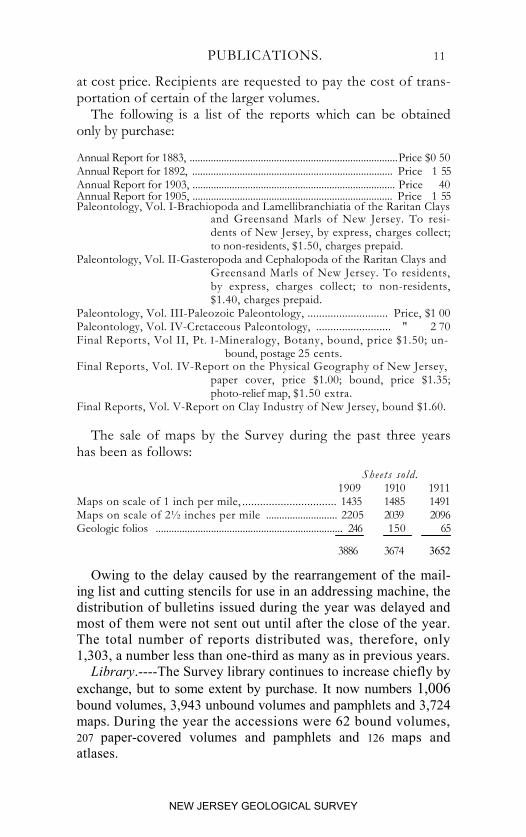
The following is a list of the reports which can be obtainedonly by purchase:
Annual Report for 1883, ...............................................................................Price $0 50Annual Report for 1892, ............................................................................ Price 1 55Annual Report for 1903, ............................................................................. Price 40Annual Report for 1905, ............................................................................ Price 1 55Paleontology, Vol. I-Brachiopoda and Lamellibranchiatia of the Raritan Clays
and Greensand Marls of New Jersey. To resi-dents of New Jersey, by express, charges collect;to non-residents, $1.50, charges prepaid.
Paleontology, Vol. II-Gasteropoda and Cephalopoda of the Raritan Clays andGreensand Marls of New Jersey. To residents,by express, charges collect; to non-residents,$1.40, charges prepaid.
Paleontology, Vol. III-Paleozoic Paleontology, ............................ Price, $1 00Paleontology, Vol. IV-Cretaceous Paleontology, .......................... " 2 70Final Reports, Vol II, Pt. I-Mineralogy, Botany, bound, price $1.50; un-
bound, postage 25 cents.Final Reports, Vol. IV-Report on the Physical Geography of New Jersey,
paper cover, price $1.00; bound, price $1.35;photo-relief map, $1.50 extra.
Final Reports, Vol. V-Report on Clay Industry of New Jersey, bound $1.60.
The sale of maps by the Survey during the past three yearshas been as follows:
Sheets sold.1909 1910 1911
Maps on scale of 1 inch per mile, ................................ 1435 1485 1491Maps on scale of 2½ inches per mile ........................... 2205 2039 2096Geologic folios ....................................................................... 246 150 65
3886 3674 3652
Owing to the delay caused by the rearrangement of the mail-ing list and cutting stencils for use in an addressing machine, thedistribution of bulletins issued during the year was delayed andmost of them were not sent out until after the close of the year.The total number of reports distributed was, therefore, only1,303, a number less than one-third as many as in previous years.Library.----The Survey library continues to increase chiefly by
exchange, but to some extent by purchase. It now numbers 1,006bound volumes, 3,943 unbound volumes and pamphlets and 3,724maps. During the year the accessions were 62 bound volumes,207 paper-covered volumes and pamphlets and 126 maps andatlases.
NEW JERSEY GEOLOGICAL SURVEY
12 ADMINISTRATIVE REPORT.
Property Records.--In May the Board of Managers instructedthe State Geologist to prepare an inventory of the property of theSurvey and to recommend a plan for keeping property recordswhich would show the property on hand and the person re-sponsible for its keeping. Certain classes of property, asstationery, are consumed in the using; other kinds, althoughsomewhat more permanent, within a short period wear out orare broken in use. This includes many classes of chemical appa-ratus; other kinds are permanent or nearly so and remain onhand indefinitely. It was essential that the system to be adoptedtake account of the different classes of property, that it be elasticenough to meet future demands, and that it be simple enough notto add greatly to the clerical work of any member of the officeforce, for manifestly it would not be good management to spendmore money in keeping track of property than the value of theproperty that might be lost or improperly used through lack ofsuch attention. Complicated systems applicable to large organ-izations may easily prove too cumbersome and expensive forsmaller bodies, where the responsibility is divided among onlya few persons at most.
The system finally adopted was to enter each article or classof articles (where there are several of one kind) on pages of aloose-leaf note book, measuring 5 x 8 inches. These areruled so as to show date of purchase, number purchased, cost,name of person to whom charged, number charged, condition,and final disposition. The property of the Survey is regardedas expendable and non-expendable. Expendable property includesall articles which are perishable or which, when applied to officialuse, are consumed or are made an essential part of an articleotherwise accounted for. Other classes of property are classedas non-expendable. Monthly abstracts will be made of all non-expendable property purchased, each article entered in the prop-erty book and charged to the proper person. Transfers, lossor destruction of property are to be reported in writing to theproperty clerk and, upon the approval of the State Geologist, areposted in the record. When this is done the person charged withthem is relieved of responsibility therefor.
NEW JERSEY GEOLOGICAL SURVEY
NOTE-TAKING. 13
Note-Taking.--During the year much thought has been givento devising a system of note-taking for field observations bywhich the exact locality of the observation can be recorded pre-cisely, briefly, and in such a way as to be intelligible to futureworkers in the same field. The common practice of a dot andarbitrary number on the field map, with a corresponding numberin the note book fails completely if the field map becomes separ-ated from the note book, or when the number of entries is solarge that several figures have to be used on the map for eachlocality. Some method was needed by which it would alwaysbe possible to fix the location on any copy of the State Atlas,irrespective of whether it was the original field map or not.Museum specimens and well records thus labeled could alwaysbe referred back to their proper location if necessary. A modi-fication of the system suggested several years ago by Prof. J. F.Kemp was finally adopted, and in the field work of the pastseason it was given a thorough test and found successful. Inorder that there may be a formal record of it for future referenceit is here described in full.
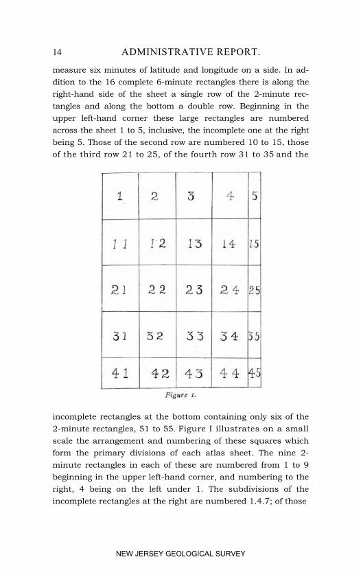
The engraved atlas sheets on the scale of 1 inch per mile formthe basis of the system. These sheets are numbered from 21 to37, inclusive. Except No. 37, which overlaps parts of Nos. 35and 36, they match edge to edge and there is no duplication ofareas on different sheets. On these sheets lines of latitude andlongitude are engraved at two-minute intervals, so the sheetsare already divided into rectangles each representing two min-utes of latitude and two minutes of longitude, and each measur-ing from east to west about 1 3/4 inches and from north to southabout 2 1/4 inches. Since each of the atlas sheets comprises 26degrees of longitude and 28 degrees of latitude, there are 13 ofthese rectangles from east to west and 14 from north to south.
Beginning at the upper left-hand corner every third engravedline of longitude and of latitude is over ruled in red ink. Theeffect of this is to divide the sheet into 16 rectangles each about5 1/4 inches from east to vest and 6 3/4 inches from north to south,and each containing nine of the smaller 2-minute rectangles.These may be briefly called 6-minute rectangles, since they
NEW JERSEY GEOLOGICAL SURVEY
14 ADMINISTRATIVE REPORT.
measure six minutes of latitude and longitude on a side. In ad-dition to the 16 complete 6-minute rectangles there is along theright-hand side of the sheet a single row of the 2-minute rec-tangles and along the bottom a double row. Beginning in theupper left-hand corner these large rectangles are numberedacross the sheet 1 to 5, inclusive, the incomplete one at the rightbeing 5. Those of the second row are numbered 10 to 15, thoseof the third row 21 to 25, of the fourth row 31 to 35 and the
incomplete rectangles at the bottom containing only six of the2-minute rectangles, 51 to 55. Figure I illustrates on a smallscale the arrangement and numbering of these squares whichform the primary divisions of each atlas sheet. The nine 2-minute rectangles in each of these are numbered from 1 to 9beginning in the upper left-hand corner, and numbering to theright, 4 being on the left under 1. The subdivisions of theincomplete rectangles at the right are numbered 1.4.7; of those
NEW JERSEY GEOLOGICAL SURVEY
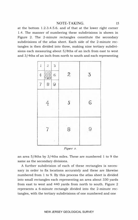
NOTE-TAKING. 15at the bottom 1.2.3.4.5.6. and of that at the lower right corner1.4. The manner of numbering these subdivisions is shown inFigure 2. The 2-minute rectangles constitute the secondarysubdivisions of the atlas sheet. Each side of the 2-minute rec-tangles is then divided into three, making nine tertiary subdivi-sions each measuring about 5/8ths of an inch from east to westand 3/4ths of an inch from north to south and each representing
an area 5/8ths by 3/4ths miles. These are numbered 1 to 9 thesame as the secondary divisions.
A further subdivision of each of these rectangles is neces-sary in order to fix locations accurately and these are likewisenumbered from 1 to 9. By this process the atlas sheet is dividedinto small rectangles each representing an area about 330 yardsfrom east to west and 440 yards from north to south. Figure 2represents a 6-minute rectangle divided into the 2-minute rec-tangles, with the tertiary subdivisions of one numbered and one
NEW JERSEY GEOLOGICAL SURVEY
16 ADMINISTRATIVE REPORT.
of these again divided into the still smaller rectangles. By writ-ing first the number of the atlas sheet, and then the number ofeach of the rectangles in order of magnitude, it is possible togive to each of these smallest divisions a number of its own,different from that of any other area in the State. This numbercan he applied to it quickly and without difficulty, or given anumber, the corresponding area can be located quickly on anyatlas sheet. In actual practice it has not been found necessaryto rule upon the field maps any lines subdividing the 2-minuterectangles. The smaller divisions can be more convenientlyruled and numbered upon a small piece of tracing cloth or oftransparent celluloid, which can be laid upon the map in thedesired position and from which the smaller numbers can beread. When not in use this is conveniently carried in a pocketin the cover of the note book. In practice a dot is made on thefield map at the point of observation, the number of the atlassheet, of the 6-minute rectangle and of the 2-minute rectangleis entered in the note book from the map. The transparentguide is laid on the map and fitted to the boundaries of the2-minute rectangle, then the numbers of the two smaller divi-sions are read off.
If the entry were 32.1.3.9.9. the locality would be on AtlasSheet No. 32 in the 6-minute rectangle No. 1 (in the upper left-hand corner), in 2-minute rectangle No. 3 (in the upper right-hand corner), and again in subdivision 9 (in the extreme south-eastern part). The actual locality is about 1 mile east by southof Pemberton, Burlington County.
If still greater accuracy is required a small rectangle, the sizeof the smallest subdivision can be drawn in the note book fol-lowing the numerical entry and in this a dot placed showingthe actual location.
If on the field map it is desirable to make reference to thenote book, the number of the note book and the page can bewritten as a fraction as, for instance, 3/4 close to the dot indi-cating the locality, the numerator giving the note book number,the denominator the page.
NEW JERSEY GEOLOGICAL SURVEY
NOTE TAKING. 17
Since the boundaries of the 2-minute rectangles are alreadyengraved on the map and the smaller rectangles are not in practiceshown, it is necessary only to outline the 6-minute rectangles bystrengthening certain engraved lines. While this is convenient,it can be omitted, and with a little extra care localities can begiven their proper number without it. The transparent guides,however, are essential to correct work.
Inasmuch as the lines of longitudes converge northward, the2-minute rectangles are not quite so wide along the northerntier of the State as at the south end of Cape May. The differ-ence, however, is but slight, and if the guides are ruled to fitrectangles midway of the State from north to south the error isbarely noticeable. In fact, it may be more than compensated forby changes in the paper with changing weather.
A complication arises in the case of Sheet 37 which overlapsthe two sheets north of it--Nos. 35 and 36. This is met by giv-ing the repeated sections of No. 37 the numbers they have asparts of Atlas Sheets 35 and 36, and regarding Sheet 37 as be-ginning at latitude 39° 04', the southern limit of Nos. 35 and 36.
A great advantage of this system is the fact that it can beapplied when copies of the original projection sheets are usedas field maps, as is often the case. Since these copies are on ascale of three inches per mile, or three times the engraved sheets,the 2-minute rectangle on the larger scale is exactly the samesize as the 6-minute rectangle on the engraved sheets, and thesmallest subdivision (330 by 440 yards) is the same size as thenext largest division of the engraved map. Hence the sametransparent guides can be used, only in that case their smallestdivisions are ignored. The field map is ruled in 2-minute rec-tangles, which are numbered to correspond to the engraved sheetsof the same area.
This plan was given a thorough test during the past seasonby several persons in field work and was found to be far superiorto any other heretofore used. The fact that all members of theSurvey staff are using the same system is in itself a great ad-vantage.
2 AD
NEW JERSEY GEOLOGICAL SURVEY
18 ADMINISTRATIVE REPORT.
TOPOGRAPHIC WORK.
Mr. C. C. Vermeule has continued in charge of the topographicwork of the Survey. Mr. P. D. Staats has been his chiefassistant.
Leveling.-Late in the autumn a line of exact levels was runin the southern part of the State under Mr. Vernleule's direction.The purpose of this work was to determine if possible whetheror not any appreciable warping of the earth's crust had occurredin that region since the lines of levels were first run, abouttwenty-five years ago. Mr. Vermeule's report is as follows:
"NEW YORK, December 14. 1911."Dr. H. B. Kümmel, State Geologist, Trenton, N.J.:
"DEAR SIR-I beg to report as follows concerning the levelingoperations in the southern part of the State executed during thepast autumn:
"Mr. Peter D. Staats, assisted by a competent and carefulrodman, Mr. Joseph H. Smith, began leveling at Cape May CourtHouse October 4th and completed the field work November 6th.The levels ran from Cape May Court House along or near theline of the West Jersey Railroad, through Sea Isle Junction andMillville to Vineland and Newfield Junction; thence returningalong or near the line of the West Jersey and Atlantic Railroadthrough Mays Landing to Absecon and Atlantic City. Therewas also a branch line run from Sea Isle Junction to Sea IsleCity, 6 miles, which, together with the 84 miles included in theline first described, made a total distance of 90 miles. Of this,19 miles was run over a second time in order to check possibleerrors, making the whole distance leveled 109 miles. The wholeperiod covered 39 working days, of which 5 days were lostthrough rain or high winds, leaving 34 working days, so that theactual rate of leveling was 3.2 miles per day.
"The instrument used was a 15-inch Gurley Y level, being aduplicate of the level used for the original work of primaryleveling executed in 1885 and 1886. The instrument was care-fully adjusted, and care was taken to equalize, so far as possible,
NEW JERSEY GEOLOGICAL SURVEY
TOPOGRAPHIC WORK. 19
the fore and back sights and to check each reading as made. Inall respects the methods adopted and precautions taken wereidentical with those adopted when the original line of primarylevels were run over this same route in 1886. The originallevels were run along the railroad lines, but the traffic at presentis much more frequent than in 1886, owing to the introductionof electricity over the larger part of the route, and also workingalong the railroad line is now more dangerous because of thethird rail. Furthermore, the improvement of the highways alongand near the route made it much more feasible to use these;consequently the levels were not confined closely to the railroadlines, but in many cases they diverged to highways parallel withand near to the railroads.
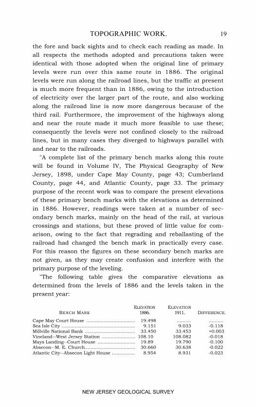
"A complete list of the primary bench marks along this routewill be found in Volume IV, The Physical Geography of NewJersey, 1898, under Cape May County, page 43; CumberlandCounty, page 44, and Atlantic County, page 33. The primarypurpose of the recent work was to compare the present elevationsof these primary bench marks with the elevations as determinedin 1886. However, readings were taken at a number of sec-ondary bench marks, mainly on the head of the rail, at variouscrossings and stations, but these proved of little value for com-arison, owing to the fact that regrading and reballasting of therailroad had changed the bench mark in practically every case.For this reason the figures on these secondary bench marks arenot given, as they may create confusion and interfere with theprimary purpose of the leveling.
"The following table gives the comparative elevations asdetermined from the levels of 1886 and the levels taken in thepresent year:
ELEVATION ELEVATIONBENCH MARK 1886. 1911. DIFFERENCE.
Cape May Court House .................................. 19.498 .......... ..........Sea Isle City ................................................... 9.151 9.033 -0.118Millville National Bank ................................... 33.450 33.453 +0.003Vineland--West Jersey Station ....................... 108.100 108.082 -0.018Mays Landing--Court House .......................... 19.890 19.790 -0.100Absecon--M. E. Church................................... 30.660 30.638 -0.022Atlantic City--Absecon Light House ................ 8.954 8.931 -0.023
NEW JERSEY GEOLOGICAL SURVEY
20 ADMINISTRATIVE. REPORT.
"Of the foregoing bench marks, those at Cape May CourtHouse and Sea Isle City are each stone posts set in concrete, asdescribed particularly in the Annual Report for 1885, page 15.The Sea Isle City bench mark, however, had to be moved someyears after the original levels were run, in order to make wayfor improvements on the lighthouse lot, and at that time itselevation was redetermined from the elevation at the originallocation. The other bench marks are all on buildings, and thelast one at Atlantic City is a bench mark of the U. S. Coast andGeodetic Survey, cut on the northwest side of the base of theAbsecon lighthouse. All of these bench marks are in satisfac-tory condition and may be considered not to have changed appre-ciably since the running of the original levels.
"It will be seen that the agreement between the levels of thepresent year and the original levels of 1886 is extremely closeand entirely within the probable error of the observations.
"The agreement throughout is such that, it may be assumedthat there has been no important relative change of elevationbetween these several bench marks during the interval from1886 to 1911.
"It appears timely and pertinent in this connection to callyour attention to the fact that, owing to the conditions of stricteconomy enforced upon the Survey during the prosecution ofthe original topographic work, for the control of which theseprimary levels were originally executed, it was impossible toexpend any large sum of money in setting bench marks. Eighteensubstantial bench marks were set along the seashore betweenSandy Hook and Cape May, but elsewhere we were forced todepend upon the more permanent structures, such as bridges andbuildings which were available along the route of our primarylevels. A far smaller number of such permanent structuresexisted twenty-five years ago, when the work was done, than areavailable at the present time, and the primary bench marks forthis reason were not as numerous as it is now possible and perhapsdesirable to make them. A considerable percentage of the benchmarks originally established have either disappeared or becomeunreliable, owing to the removal or settlement of the structures.
NEW JERSEY GEOLOGICAL SURVEY
TOPOGRAPHIC WORK. 21
It would, therefore, appear that it might be desirable at the pres-ent time to establish a very considerable number of additionalbench marks upon the larger number of durable structures nowavailable for that purpose. If this is done at the present time,we shall be able to utilize all of the primary bench marks whichnow continue in existence. If it is deferred for any considerableperiod, you can appreciate that the number of these bench marksavailable will continually decrease, and an increasing percentageof the value to be derived from the original primary levels willdisappear.
"I am not convinced by experience that the setting of specialpermanent bench marks is likely to give substantially betterresults than the utilizing of existing structures. Of the eighteenbench marks originally set, we have already found it necessaryto re-establish two, and it is very difficult to find locations forsuch marks which will be secure against possible future inter-ference through grading operations or the using of the locationfor buildings or other structures. It does not seem that suchbench marks will be substantially more permanent than benchmarks on the more durable bridges and public buildings, whereasthey will be very considerably more expensive.
"Respectfully submitted, "C. C. VERMEULE."
GEOLOGIC WORK.
Report on plant remains of the Raritan clays.--For severalyears a small allotment was made to Mr. E. W. Berry, of JohnsHopkins University, to enable him to collect and study the plantremains which are found in the Raritan clay deposits.
The Raritan formation appears at the surface in a narrow beltextending across the State from Woodbridge and South Ambovon Raritan Bay, to Trenton and thence along Delaware River toSalem County. Over much of this distance it is covered by alayer of yellow gravel of variable thickness and very muchyounger in age, so that even within this belt it is exposed onlyat intervals in clay pits or in natural sections along stream banks.The best exposures are in Middlesex County where it is exten-
NEW JERSEY GEOLOGICAL SURVEY
22 ADMINISTRATIVE REPORT.
sively mined in enormous pits. It is also shown in numerouspits near Trenton and at various points in the bluffs along Dela-ware River and its tributaries south of Trenton.
The Raritan formation is made up for the most part of alter-nating beds of clay and sand with local lignitic deposits andgravel. The clays are of variable kinds, some sandy, some con-taining lignite and iron pyrite, some fat; some are suitable onlyfor the manufacture of fireproofing, hollow brick or commonbuilding brick: others are available for architectural terra cottaand some are white high-grade fire clays. These clays havebeen fully described and their occurrence shown in the Reporton Clays, Volume VI, of the Survey Reports.
Borings have shown that the Raritan formation continuessoutheast from the narrow belt along which it outcrops and thatin this direction it is overlain by other beds of clay and sandwhich were deposited at successively later periods. Since theseformations all slant gently to the southeast the Raritan bedsoccur at constantly greater depths in that direction until alongthe oceanward side of the State, as at Atlantic City, they areapproximately 2,300 below sea level.
Certain layers of this formation have long been known tocontain plant remains, the first fossil plant from it having beendescribed by Conrad from the banks of South River in 1869.The leaf impressions in the clays early attracted the attentionof Dr. George H. Cook, then State Geologist, and collectionswere made. In the Clay Report of the State Survey, issued in1878, a certain layer of clay in the vicinity of Woodbridge wascalled the "leaf bed" and a list of species identified by ProfessorLesquereaux was published in that report. In 1896, the U. S.Geological Survey published an elaborate posthumous work byProfessor Newberry on the Flora of the Amboy Clays, whichincluded, however, some species outside the Raritan formation.The interval of time since the termination of Newberry's activework upon these plant remains and the prodigious progress inthis country both in geology and paleobotany in the last twodecades has made it possible for Mr. Berry by his recent studiesto add much to our knowledge of this subject. In these studies
NEW JERSEY GEOLOGICAL SURVEY
PLANT REMAINS, RARITAN FORMATION. 23
he had access to all of Professor Newberry's types, as well asto much other material, some of it collected by himself.
In his report, Mr. Berry, after describing the Raritan forma-tion and giving a brief sketch of previous investigations, dis-cusses its place in the geological column and its correlation withEuropean formations as indicated by the plant remains. Heregards it as equivalent to a part of the upper Cenomanian ofEurope. The present enumeration of Raritan plants embracesbetween 160 and 170 species, the botanical relations of a few ofwhich are unknown. The balance belong to the following greatbotanical families. One fungus and one alga are recognized,although probably many others existed. There are nine speciesof fern plants (pteridophytes). The great bulk of them belongto the seed plants (spermatophytae), and of these 24 to thegymnospermae or naked seed plants, which is almost twice asmany as are present in the recent flora of the State. During theperiod when the Raritan clay was being formed, the gymno-sperms were therefore relatively much more abundant both inindividuals and in species than in recent floras. Two of thesebelonged to that very singular order whose sole surviving repre-senative is the Maidenhair tree, indigenous in eastern Asia, butnot infrequently cultivated as an ornamental tree in our parks.There were also two or three species of the Sequoia which arenow represented by the giant redwoods of the Pacific coast.The angiosperms, usually called "flowering plants," make up thebalance of the flora, all of them being dicotyledons except asingle species. Among these were represented the figs, magno-lias, tulip trees, laurel, cinnamon and other forms referred tomodern genera, but not to modern species.
While the flora as a whole differs from any modern Americanflora with which it may he compared, it is distinctly suggestiveof existing floras. That is the same plant groups which domi-nate in the present flora of the globe are largely represented.Of the 78 known genera from the Raritan only 32 are extinct.and 11 of these are gymnosperms or lower plants. Not a fewgenera, however, although not extinct, are not now found inNew Jersey. In fact, some of them found here in Raritan timeare now restricted to the Southern hemisphere.
NEW JERSEY GEOLOGICAL SURVEY
24 ADMINISTRATIVE REPORT.
Mr. Berry points out that species identical with those foundin New Jersey occurred also as far north as Greenland and asfar south as Alabama. From this it can be safely inferred thatthe climate of that period was very different as a whole fromthe present one. It was certainly more uniform than at present,both as regards seasonable changes and zonal differentiation.
One of the most interesting of the author's suggestions is thatthis flora originated in the Arctic area and spread thence toNorth America, Europe and Asia, so that we may tentativelypicture successive waves of plant migration sweeping southwardfrom the polar regions.
The greater portion of the report is taken up with a detaileddescription of the plant remains, the more characteristic speciesor the forms never before described or figured being illustrated.The report was published as Bulletin III.
Report on the fish remains of the Cretaceous, Eocene andMiocene formations of New Jersey.--The greensand marl bedsof southern New Jersey have been the prolific source of fishremains as well as of other fossils. Shark's teeth ranging insize from a small fraction of an inch to huge affairs 5 inchesor more in length were preserved in great numbers and are nowfound in many collections. No shark of modern times ap-proached in size the giant Carcharodon polygurus which swamthe seas then covering the southern portion of our State. Itslength is estimated to have been between 85 and 90 feet, or overtwice the length of the largest known existing fish. The cuttingedges of its teeth were serrated and often very sharp. Thismonster was widely distributed in the Cretaceous and Tertiaryseas of long ago, and its fierce search for food must have ren-dered incessant the butchery of the majority of aquatic animals.Besides this giant, twenty-eight other species of sharks havebeen recognized from the remains found in the marl pits of theState, but no one of these is known to exist at the present day,although in many instances they are represented to-day by closelyallied forms.
Sharks, however, are not the only fish whose remains have beenfound in these deposits. Rays, with their broad, flat, disk-likebodies and slender tails, swam along the ocean bottom, and with
NEW JERSEY GEOLOGICAL SURVEY
FISH REMAINS. 25
their large grinding teeth crushed the thick-shelled molluskswhose shells we also find in innumerable numbers in the marlbeds. The existing species, about 15, are large sting-rays, whichare found in most all warm seas, but about 80 extinct specieshave been described, of which 10 are known to have lived in thisregion and have been identified by their dental plates. Oneof the largest of these plates, measuring 61/2 inches in lengthand 4 inches in width, from the Shiloh marl of CumberlandCounty, was sent to the Survey in 1880 by Isaac Smalley. Forthirty years it remained in the collections unidentified until ex-amined last year by Mr. Fowler. He was unable to correlateit with any species heretofore recognized and therefore it wasdescribed as a new species of the genus Myliobatis.
Teeth of an allied form were recently found in boring a wellat Fortesque Beach, on Delaware Bay, at a depth of 214 feet,showing that since the lifetime of the fish at least that amountof sediment had accumulated in that vicinity. In fact, beds to amuch greater thickness than 200 feet have been formed, for sincethese remains were deposited there have been long periods oferosion as well as deposition, and the depth of sediments inwhich they are now interred indicates not the total depositionsince that period, but the difference between deposition anderosion.
Other fish are represented by fragments of bones--vertebraeor jaw bones chiefly-and a few by spines, or scales. In nocase have any complete skeletons nor impressions of the bodybeen preserved, as was the case with the earlier fish found atBoonton in the shale beds of the Newark or red sandstone forma-tion. The great difference in this respect will be seen by a com-parison of the illustrations accompanying the report by Dr. East-man on the Triassic Fishes, published in the Annual Report ofthe State Geologist for 1904, and those accompanying Mr. Fow-ler's paper on the Cretaceous and Tertiary fish, recently pub-lished as Bulletin 4. In the former case the remains were interredin sediment which was soon consolidated into hard rock and inwhich the outlines of the body, fins, scales, etc., were perfectlypreserved, in some instances the most delicate markings being
NEW JERSEY GEOLOGICAL SURVEY
26 ADMINISTRATIVE REPORT.
now clearly visible. The later deposits, on the contrary, havenever been consolidated into rock, but have remained soft andincoherent. Near the surface they have been subject to theleaching action of underground waters, which have largely car-ried away much of the soluble compounds. Only the moreindestructible portions of the skeletons, such as teeth with theircoating of enamel, have commonly been preserved.
In the preparation of his report, Mr. Fowler had access to thecollections of the Academy of Sciences of Philadelphia, wheremuch of the material collected from the marl beds has been pre-served. Some is in the Geological Survey Museum. His reportgives a descriptive summary of the fish remains, many of whichhad not before been studied. In most cases each species has beenillustrated and described from the specimens, although in somecases it was necessary to use the original accounts by otherworkers. While the report is quite technical and, perhaps, of notgreat interest to the general reader, it is a valuable work of ref-erence and a summary description of these remains as nowknown from New Jersey.
Mineral production.--New Jersey is not commonly regardedas a State of great mineral wealth. Neither gold, silver, lead,copper, coal, oil nor gas are mined within her borders in com-mercial quantities. Nevertheless, the value of her mineralproducts as shown by statistics collected jointly by the Federaland State Surveys amounted to $35,184,692 in 1910, or $4,278per square mile of territory. The mineral production persquare mile of Pennsylvania in 1909 was about $12,254; of NewYork, about $1,324; of Ohio, $4,704; of Illinois, $2,525; ofCalifornia, $505; of Colorado, $569; of Alabama, $803, and ofWest Virginia, $3,598. The above comparison favors NewJersey slightly in that the production of 1910 was used for thisState and of 1909 for the others. Returns for 1910 wouldprobably show slightly larger production in the case of theStates cited and so raise their per mile production slightly, butit would not affect the general result. Of all the States inthe Union only two--Pennsylvania and Ohio--exceed New Jer-sey in value of their mineral production per square mile. On
NEW JERSEY GEOLOGICAL SURVEY
MINERAL PRODUCTION. 27
this basis many of the great western commonwealths, like Col-orado, California, Utah, which we are wont to consider as thegreat mining States, are found to have a production of onlyone-eighth or one-tenth that of New Jersey. In the face ofthese figures it may be well to revise our opinion and recognizethe position New Jersey in reality holds.
It is true that these figures of mineral production relate insome instances not to the raw material but to the first manufac-tured product, and in a comparison between States it sometimeshappens that one State is credited with a manufactured product,the raw material of which comes from another State. Thus inthe figures cited Pennsylvania gets credit for $179,000,000 ofpig iron, the ore of which came chiefly from Minnesota andMichigan. Some of the raw materials contributing to NewJersey's clay industry which totaled upwards of $18,400,000were not mined here. In spite, however, of these limitationsthe comparison is an instructive one and shows that New Jerseyranks very high among the States in mineral wealth.
Well records.--The collection of data regarding the under-ground water of the State has been continued by H. M. Poland.Ninety-seven new well records and 42 sets of samples have beenobtained through the courtesy of the well drillers. In additionto these the Survey has been fortunate in receiving from theU. S. Engineer's office of the War Department a complete set ofspecimens from the borings along the route of the proposed shipcanal across New Jersey from Delaware River to Raritan Bay.These borings were located at an average distance of every halfmile and were carried to a depth of 23 feet below low tide.
Wells at State Institutions.--Within the past few years ap-propriations have been made by the Legislature to a number ofState institutions for the purpose of sinking deep wells to obtainpurer, more abundant, or cheaper water supplies. The StateHome for Boys at Jamesburg, the Rahway Reformatory, theGlen Gardner Sanitarium, the State Hospital for Insane atTrenton, and the State Prison, are some of those to which suchappropriations were made. In some of these cases the resultshave not warranted the outlay involved, from failure to obtain
NEW JERSEY GEOLOGICAL SURVEY
28 ADMINISTRATIVE REPORT.
either the desired quantity or quality. In one or two instancesthe advice of the State Geological Survey was requested by theManagement of the Institution in advance of the application tothe Legislature, but in more cases it was not. In at least oneinstance an adverse opinion did not deter the management fromasking and obtaining an appropriation and drilling a well whichwas at first a failure through an insufficient supply and laterwhen a greater supply had been obtained, was a failure becauseof surface contamination. Since in not one instance, but inseveral, have efforts of this kind been unsatisfactory, the sug-gestion is made that questions of this character might properlybe referred to the Geological Survey for a report on the probableoccurrence of ground water of the quantity and quality desired.In consequence of the investigations of the survey, which haveextended over a period of more than fifty years, much informa-tion has been secured regarding the occurrence of undergroundwater. Records of several thousand wells are on file in the Sur-vey office, and the State Geologist is in a position to adviseregarding the probable occurrence of ground water in any givenlocality, and the probable success or failure of wells. It is, ofcourse, not possible always to predict with absolute certainty theamount to be found, or the depth, or the quality, but everygeologist knows that some geologic conditions are much morefavorable to its occurrence than others. It may also be said thatthe geologic structure of the State is so well known that therecan be little question of the character of the rock to be found indrilling at any point. It would seem, therefore, that conserva-tion of resources and economy of expenditure should demandthat all the knowledge of the Survey be utilized before any pro-ject for sinking wells for State institutions be sanctioned by theLegislature. A request from the chairman of the Appropria-tions Committee for information on any proposed boring couldin all ordinary circumstances be answered within a few days,before the next meeting of the committee, so that there need beno delay in this procedure.
Report to the Managers of the Woman's Reformatory.--InSeptember, at the request of Mrs. C. B. Alexander, President of
NEW JERSEY GEOLOGICAL SURVEY
UNDERGROUND WATER SUPPLIES. 29
the Board of Managers of the Woman's Reformatory, I madean examination of a tract of land near Clinton, HunterdonCounty, which they had under consideration as a site for theproposed reformatory. The purpose of the investigation was todetermine the probability that an adequate supply of watermight be obtained. The report was as follows:
"TRENTON, N.J., September 6, 1911. "Mrs. C. B. Alexander, President, Board of Managers, Women's
Reformatory, Bernardsville, N. J.:"DEAR MADAM--Pursuant to your request I have made an
inspection of the George Smith farm, near Clinton, and begleave to submit the following memorandum:
"The farm contains something over 300 acres lying in theangle between the Easton and Amboy turnpike and the Clinton-Pittstown road, with a frontage of over a mile along the formerroad.
"The general elevation is about 360 feet above sea level, but thefarm is traversed from north to south by an open valley sunkabout 80 feet below the general level. This valley is drained bya small brook, fed, except in wet weather, exclusively by springsarising on the farm. In wet weather it receives at its head thesurface drainage of fields lying on the north side of the Amboy-Easton turnpike.
"The underlying rock on the farm is chiefly a red, black andyellow shale, but on the west side of the brook limestone is ex-posed in a small quarry and so far as surface indications are aguide the limestone underlies the southwest corner of the farm.On the higher levels and upper slope the rock seemingly lieswithin three or four feet of the surface, as was shown bynumerous post holes. On lower slopes and along the flat valleybottom it probably lies much deeper.
"Water Supply.--As above stated, numerous springs issuealong the valley bottom to form the small brook which drains it.Most of these manifest themselves as small swampy places alongthe valley bottom. The largest is at the old milk house on thewest side of the brook near the southern boundary of the prop-erty. This spring has a good flow although nothing unusual.
NEW JERSEY GEOLOGICAL SURVEY
30 ADMINISTRATIVE REPORT.
Owing to the Way in which most of the water is now escaping,i.e., seeping out in many boggy places, it is very difficult to makean estimate as to the total flow of these springs. My own expe-rience in estimating stream flow is so limited that I prefer notto give any figures, but I am of the impression that by properlydeveloping all the springs along the valley bottom connectingthem by subterranean galleries, and conducting the water bygravity to a receiving well, a considerable supply could bedeveloped.
"Water from deep wells.--Statistics show that about ninetyper cent. of the wells drilled in shale and slate similar to thatunderlying most of the Smith farm are successful in obtainingwater, i.e., water enough for a single family. This may, how-ever, be only one or two gallons per minute, Of one hundredwells, forty-three yielded 1 to 5 gallons per minute, while onlysix yielded more than 50 gallons. Five gallons per minute is7,200 per day (24 hours). Assuming that you would ultimatelyneed 25,000 gallons per day (50 gallons per capita for 500 per-sons--a low estimate) you would need about 18 gallons perminute, and judging from results elsewhere there would be onechance in three of obtaining this amount from a single well. Aflowing well is not probable, although not impossible if drilledin the valley bottom.
"Quality.--I have made no analysis of the water as that isa matter for the State Board of Health. The large spring at themilk house issues from limestone and is hard water (carbonate oflime and magnesia). The water from the shale and slate wouldbe softer. If proper care was taken regarding the disposal ofsewage and other wastes from the institution, I believe therewould be no danger of contamination of the springs. Since,however, some at least of this spring water has traversed crevicesin the rock, perhaps for some distance, there is more chance forthe transmission of pollution than if the water filtered through asand bed.
"Yours truly, HENRY B. KÜMMEL, "State Geologist."
NEW JERSEY GEOLOGICAL SURVEY
COASTAL CHANGES. 31
Coastal Stability versus Coastal Subsidence.--In the AnnualReport of the State Geologist for 1885, Dr. George H. Cookdescribed in great detail many changes which had been observedwithin historical times along the New Jersey coast. From astudy of these facts it was concluded, "That there is a changein the relative level of the sea and the land going on now; thesea rising upon the land. The marshes now cover land whichsince the first settlement of the country has been above tidelevel and cultivated in farm crops. Trees formerly grew wherethe salt-marsh now covers the surface, and only salt-grass orother marsh vegetation can grow, * * * *. In manyplaces, too, Indian shell heaps are found in the marsh, and, go-ing down to hard ground, the marsh has evidently grown uparound them since they were begun, Marsh sods are foundunder the beaches and along the strand, which, though in theirplaces of growth, are several feet below tide level. The stormsand waves of the sea appear to have greater effect in wearingaway and changing the shore line than they had in former times.This would naturally occur if the sea rises higher on the landthan it formerly did." (Loc. cit., pp. 57, 58.)
Again speaking of the tide meadows, Cook said: "As thesemeadows are of such recent date we might expect to obtainfrom them abundant evidence of any change of level which mayhave occurred during their formation, and in this expectationwe are not disappointed. We find, in fact, conclusive evidenceof a general subsidence of the coast or rise of the water level toan extent of from ten to twenty feet within a short period ofgeological time, but at a rate which is not yet quite definitelyestablished."
The points of evidence alluded to are as follows:
"1st. The encroachment within the present generation of thesalt-meadow on the upland, in many places killing timber alongthe border and rendering arable land unfit for cultivation.
"2d. The stumps of trees in the mud, with their roots im-bedded in hard bottom, many feet below high-water mark, andat a level where they could not possibly have grown previous tothe formation of the marsh.
NEW JERSEY GEOLOGICAL SURVEY
32 ADMINISTRATIVE REPORT.
"3d. The occurrence of Indian or aboriginal shell beds restingon hard bottom and partly or wholly submerged in the meadowto the depth of some feet. These were unquestionably formedon knolls of upland which projected above the surface, and havesince become buried by the rise of the meadow.
"4th. The existence of old bridges and crossways of poles orcorduroy roads several feet below the surface of the marsh. Thetime of their construction is unknown to the present generationof inhabitants, and there seems to be no authentic record of anybridges, built within the memory of the inhabitants on the shore,having settled or sunk in the marsh to an appreciable extent; sowe may, with justice, conclude that they have been buried by theupward growth of the meadow.
"5th. The occurrence * * * of the meadow-sod belowlow-water mark on the outer shore [of the beaches], at a levelwhere experience and observation show the grass could neverhave grown." (Loc. cit., pp. 62, 63.)
Nearly thirty years previous, Prof. Cook, in a paper beforethe American Association for the Advancement of Science, in1857, had cited many facts indicating, in his opinion, that thecoast was sinking at the rate of two feet per century. His con-clusions were accepted apparently without much question and therate given found its way into several standard text-books onGeology (Dana, Le Conte, et al.) and has been widely quoted,until it has come to be regarded as an established fact. It is in-teresting to note, however, that Cook in 1857 himself stated thatthe rate of subsidence, although based on observations by variouspersons, which were in surprising accord, was not substantiatedby so large a body of fact as to make it beyond question. Infact, he expressly stated that other data which would probablybe found might show very different rates. It is also worthy ofnote that writing in 1885, after reviewing all the data, he ex-pressly states the subsidence is "at a rate which is not yet quitedefinitely established" and nowhere in his later paper (1885)does he allude to the rate in any definite terms. It may be fairlyinferred therefore that Cook, although holding firmly to hisearly belief in subsidence, was not disposed to regard the twofeet per century rate as established.
NEW JERSEY GEOLOGICAL SURVEY
COASTAL CHANGES. 33
Since 1885 the study of coast lines has made great progressand the criteria for distinguishing stationary from sinking coastshave been carefully worked out. It has been recognized also thatother factors than coast subsidence may at certain localitiescause the high tides to encroach upon the land. In other words,more careful study of tides and the factors which determinetheir height in bays, lagoons, and tidal streams has completelydemonstrated that at many localities the average high tide leveldoes not remain constant, but that changes in the shape ofinlets, filling up of lagoons, recession of the mouths of tidalstreams with resulting shortening of their courses, may causethe high tide at any given locality to rise higher than formerlyand the tide marsh, whose level is determined by the high tide,to encroach upon the main land. Recognition of these facts withothers, the importance of which does not seem to have been fullyconsidered by most of the earlier workers, has led some geolo-gists to question these conclusions, and to re-examine the factsto determine whether or not they were susceptible of anotherinterpretation.
A year ago, Prof. D. W. Johnson, of Cambridge, Mass.,began the study of this problem as related to the Atlantic coastfrom Nova Scotia to Florida, under the auspices of the ShalerMemorial Fund of Harvard University. With the consent ofthe Harvard authorities, it was possible for the State Survey toco-operate in this work so far as it concerned New Jersey.Prof. Johnson and party accordingly spent two weeks or morealong both the Delaware Bay and Atlantic shores in a critical ex-amination of this problem. Fortunately the Survey already hada vast amount of data directly applicable to the work, regard-ing the height of the tide marsh and of high tides, as well as thedetailed statements of conditions as observed by Prof. Cook.This greatly facilitated the work and rendered it possible tomake much greater progress in a limited time than in a regionless well known.
In the investigation under Prof. Johnson's direction, the tidemarsh was sounded at many points to determine its depth, andsamples of the buried marsh vegetation taken for botanical study.
3 AD
NEW JERSEY GEOLOGICAL SURVEY
34 ADMINISTRATIVE REPORT.
Synchronous observations were made on the height of a hightide in the ocean, the lagoon and far up the tidal streams, allmeasurements being referred to the same absolute datum plane.Observations were also made regarding many other matterswhich had a bearing upon possible changes of level. The StateGeologist was with the party during a portion of its work. Theresults of Prof. Johnson's investigations so far as they relate toNew Jersey will be presented in a special report to the StateGeologist and will be published as a Bulletin of the Survey assoon as possible. His summary of his conclusions is as follows:"* * * there has been no appreciable subsidence of this coastwithin the last few thousand years. The phenomena which seemto indicate recent subsidence appear to fall into three groups:(1) Ficticious appearances of subsidence which are produced bywave action on a retrograding shore line without any change inthe level of land or sea; to this group belong many instancesof submerged stumps, peat exposed at low water on the seawardside of harrier beaches, erect trees recently killed by the invasionof salt water, etc. (2) Phenomena produced by a local rise inthe high tide surface, due to a local change in the form of theshore line, unaccompanied by any general change in the relativelevel of land and sea; in this group may be found examples ofpractically all phenomena ordinarily attributed to a recentsubsidence of the land. (3) Phenomena produced by an actualsubsidence of the land or rise of the sea level which occurredsome thousands of years ago: in this group belong many ofthe deeply buried peat deposits and submerged stumps. Theevidence of coastal stability [in recent times] consists of (1) theform and position of successive beach ridges, the oldest of whichwere built by the waves thousands of years ago, yet later thanthe deeply buried peat deposits; (2) the position of abandonedmarine cliffs on which the waves cannot have worked in recenttime; and (3) the absence of a fringe of dead trees on thoseportions of the coast which are exposed neither to direct waveattack nor to local fluctuations of the high tide surface. It isconcluded with reference to the Atlantic coast, that the landcannot have subsided as much as a foot within the last century;
NEW JERSEY GEOLOGICAL SURVEY
GREEN POND MOUNTAIN BELT. 35
that there can have been no long-continued, progressive subsi-dence at so high a rate as one foot per century, within the lastfew thousand years; and that no evidence thus far available canbe regarded as satisfactory proof of any degree of recent subsi-dence, either spasmodic or progressive."
Professor Johnson's full report will probably be somewhatdelayed in submission owing to his absence in Europe in thecontinuation of these studies, but when published it will be anextremely interesting one which will appeal to large numbers ofour citizens, particularly those familiar with the phenomena withwhich he deals. So far as the edition warrants it will be dis-tributed without charge to all who request it.
Green Pond Mountain Belt.--In the Annual Report for 1901there was published a map and discussion of the geology of theGreen Pond Mountain region. This is a narrow belt of con-glomerate, sandstone, shale and limestone of Paleozoic age in-folded and down faulted in the much more ancient pre-Cambriancrystalline rocks. It includes Copperas, Kanouse, Green Pondand Bearfort mountains and intervening valleys, and extendsfrom near Flanders, in Morris County, northeast into New York.Green Pond and Greenwood Lake occupy portions of the valleysand the rugged cliffs and peculiar reddish conglomerate studdedwith white quartz pebbles are more or less familiar to all visitorsto these lakes.
This belt is a region in which the tremendous forces withinthe earth's crust have been exercised in a highly effective mannerin folding the rock strata and in causing great dislocations, alongwhich the strata have been shoved past one another. One effectof these dislocations or faults is to bring into contact with eachother strata which may normally be widely separated. In someinstances where the plane of dislocation is inclined strata ofgreater age may be overthrust upon beds much younger, so thatthe apparent order of succession is reversed. In regions of greatdynamic activities instances are known where the overthrustmass has been moved horizontally several miles.
As has already been said the Green Pond Mountain region isone of close folding and faulting. It is bounded on the west by
NEW JERSEY GEOLOGICAL SURVEY
36 ADMINISTRATIVE REPORT.
a great dislocation separating the Devonian beds of BearfortMountain from the pre-Cambrian crystallines of WawayandaMountain. A similar fracture follows the well-known LongwoodValley, famous in the earlier days of iron-making for its lineof forges. In both these cases the beds on the east have beendepressed hundreds and probably several thousand feet, as com-pared to those on the west. These geologic features were de-scribed in the report issued in 1901 and may be familiar to manyof my present readers. They are referred to here for severalreasons. The southern portion of this belt lies within the areaof the Raritan quadrangle of the geologic atlas of the State. Thegeologic folio covering this area will, it is hoped, soon be issuedin co-operation with the United States Geological Survey. Themaps have been in the hands of the engravers for a long timeand most of the proofs have been corrected. The folio when pub-lished will be uniform with the Passaic, Franklin Furnace andother geologic folios already published and will be sold at anominal price. The major portion of the region, however, lieswithin the territory of the Ramapo-Greenwood Lake quadrangle.Preparation of manuscript and maps for this folio occupied con-siderable of my time during the early part of the year. It ishoped that they will be ready for the engraver in the near future,but the folio will not be ready for distribution for a year ormore.
The Green Pond Mountain belt does not terminate at the NewYork-New Jersey State line but extends northeastward nearly toCornwall-on-the-Hudson, New York. Through the courtesy andco-operation of Dr. John M. Clarke, State Geologist of NewYork, I was able during the past season to extend my studiesthrough the whole of the New York area. In this region thestructure is more complicated than in New Jersey and the evi-dence of overthrust faults is more conclusive. In particular aseries of high hills northeast of Warwick, N. Y., known asBrimstone Mountain, Sugar Loaf, Goose Pond Mountain. andseveral smaller unnamed elevations were found to be masses ofpre-Cambrian gneiss overthrust from the east and resting uponcrushed and contorted beds of black slate of Hudson River age,
NEW JERSEY GEOLOGICAL SURVEY
SOIL INVESTIGATIONS. 37
a formation very much younger than the gneiss and, where thesuccession of strata are normal, separated from it by 3,000 feetmore or less of limestone and sandstone.
As a result of these studies in New York it was possible tocome to a better understanding of the sequence of strata for thewhole region and to reconcile some doubtful points regardingtheir correlation. A detailed report will be prepared as soon aspress of other duties will permit.
SOIL INVESTIGATIONS.Field Work.--The co-operative work in the examination and
mapping of the soils of the State undertaken several years ago inconjunction with the Bureau of Soils at Washington, D. C., andthe State Experiment Station at New Brunswick continued dur-ing 1911. Mr. Henry Jennings of the Bureau of Soils was inthe field chiefly in Passaic, Morris and Warren counties fromearly in the spring until late in October or early November.During July and most of August he was assisted by I. V. Stone,whose services and expenses were paid by the State GeologicalSurvey. Mr. Stone resigned near the close of August.
During July and August, Ray Pinkle, of Sussex, andTheodore Van Winkle, of Rutherford, were employed by theSurvey in the agricultural canvass, which is carried on syn-chronously with the soil survey. These men visited each farmwithin the territory covered by the soil survey, and obtainedfrom the occupant a great variety of information regarding thecrops, methods of culture, fertilizers used, yield per acre, etc.Each farm was located on the sheets of the State Atlas by asystem, of numbers which fixes its place permanently in therecords of the Survey and will permit its relocation at any timeon any copy of the State Atlas, even although the original fieldmaps used in the canvass are lost.
The soil survey and the agricultural canvass have now coveredthe areas shown on Atlas Sheets 21 and 22, about 850 squaremiles. These comprise practically all of Sussex County, thenorthern part of Warren County, the western part of Passaicand the northern part of Morris. Upon the completion of the
NEW JERSEY GEOLOGICAL SURVEY
38 ADMINISTRATIVE REPORT.
field work in this area Mr. Jennings was transferred by theBureau of Soils to western Tennessee for the balance of the fieldseason. The preparation and printing of the soil map is to bedone under the direction of the Bureau of Soils at Washington,and it is expected that the preliminary steps to publication willbe taken at once. The compilation of the statistics gathered inthe farm canvass is being made by the experts at the State Ex-periment Station and will be completed as soon as possible.
Analysis of Soils.--In the progress of the work all types ofsoils which have been differentiated were carefully sampled byMr. Jennings and his assistants. These have been analyzedboth chemically and physically, the former work being donelargely by Mr. Gage in the laboratory of the State Survey. Dur-ing the year he analyzed about 100 samples, making an averageof sixteen determinations on each sample. Not infrequently thework is checked over in order to avoid errors, so that the numberof determinations has been much increased. In this work Mr.Gage has had the assistance of Fred Baumann for a portion ofthe time. Under the terms of co-operation a portion of Mr.Gage's salary which was properly chargeable to the analyses ofsoils was paid by the State Experiment Station.
TESTING OF OIL AND BITUMEN FOR ROAD MAKING.
The Survey has continued to co-operate with the State RoadDepartment in the examination and testing of materials usedin road construction, particularly oil and bitumen used as abinder. Every car of oil before use has been sampled, the samplebeing sent to the Survey laboratory to determine whether or notit conformed to specifications. Over 100 samples of thesematerials have been received and examined. In addition to thiswork twenty-five pavements already laid were sampled by cuttingblocks from them, and the percentage of bitumen used de-termined by analysis. Mr. Gage also did considerable experi-mental work with various road materials from which muchvaluable information was obtained. Had some of these resultsbeen sooner determined many times the cost of the investigationswould have been saved in the construction of roads.
NEW JERSEY GEOLOGICAL SURVEY
CO-OPERATIVE WORK. 39
Besides the laboratory work Mr. Gage spent more or less timein the field in the examination of bituminous pavements andoiled roads which had become defective or were showing signsof deterioration by weathering or wear, for it is necessary tosupplement the laboratory tests by such study. The behavior ofthe material under the trying tests and severe conditions imposedby actual use must be observed.
That the co-operation between the Survey and the Road Com-missioner's Department has been of value to the State is shownby an extract from a letter of Col. Stevens, the Road Commis-sioner, in which lie says: "Referring to the relations between thisdepartment and yours, and especially to Mr. Gage's services, Iwant in the first place to express my appreciation of the kind-ness of your Board in allowing Mr. Gage to continue work forus. His services have been of inestimable value; in fact, I do notknow how we could have gotten along without him." Inasmuchas a portion of Mr. Gage's salary has been paid from the ap-propriation for the Road Department, the co-operative workhas not cost the Geological Survey a large sum, and by it theState has been saved the expense of establishing and maintain-ing two laboratories.
CO-OPERATIVE WORK.
In addition to the co-operative soil investigations with the U.S. Bureau of Soils and the State Experiment Station to whichallusion has already been made, the Survey continued its jointwork with the U. S. Geological Survey; in the collection of min-eral statistics; the collection of well data, and the preparation andpublication of geologic folios. The progress made in these lineshas already been described.
MEETINGS AND CONVENTIONS.
In accordance with the policy of the Board of Managers thatthe State Geologist should attend in an official capacity the meet-ings of other State Geologists, Geological societies and conven-tions dealing with subjects pertinent to the work of this depart-
NEW JERSEY GEOLOGICAL SURVEY
40 ADMINISTRATIVE REPORT.
ment, and at which the State Survey might properly be rep-resented, he was present at the following meetings:
In December, 1910, at Pittsburgh, meetings of the Associa-tion of American State Geologists; of the Geological Society ofAmerica; of the Paleontological Society and of the AmericanGeographers, three days.
In April, 1911, at Washington, a conference of the StateGeologists of the country with the Director of the U. S. Geo-logical Survey, the Director of the Mines Bureau and the Di-rector of the Bureau of Soils. These conferences lasted threedays.
In October, at Chicago, the meeting of the American MiningCongress, four days and immediately after--
In Pittsburgh, the first National Mine Safety DemonstrationMeeting, two days.
Association of State Geologists--At the meeting in Pittsburghof the State Geologists' Association, problems relating to theadministration of State Surveys were discussed, with a freeinterchange of ideas regarding methods of office management,record keeping, and making known to the public the results ofthe Survey investigations. These meetings, which have beenheld at least once a year for several years, have been found to beextremely helpful to those participating in them.
The meetings of the Geological and other societies were takenup with the presentation and discussion of scientific papers relat-ing to geology, paleontology and geography.
At the Washington meeting in April the State Geologists metwith the Directors of several Bureaus of the Federal Govern-ment to consider plans for co-operative work during the yearand to avoid the duplication of effort which might otherwiseoccur where State and National Bureaus are working in the samefield. At a meeting of the same character held the previous yeararrangements had been made for the preparation and publica-tion of a bulletin giving the history, organization and work of thevarious State Surveys. The editing and publication of thisbulletin was undertaken by the U. S. Geological Survey aftereach State Geologist had prepared and forwarded the manuscriptregarding his own State. This bulletin, No. 465 in the series of
NEW JERSEY GEOLOGICAL SURVEY
MEETINGS AND CONVENTIONS. 41
U. S. Geological Survey publications, was issued in April. Itgives the history and work of thirty-four State Surveys and ofthree State Bureaus of engineering or hydrology. It is a mineof information for anyone desiring knowledge regarding theGeological Survey of any State. In presenting in a comprehen-sive and compact form the facts regarding the State Surveys, itemphasizes the importance of this work and the degree to whichthe various States through their Legislatures have recognizedits value and by appropriations given it support.
It is interesting to know that with the possible exception ofNew York, New Jersey has maintained a State GeologicalSurvey without interruption of support for a longer period thanany other State. The present organization was established in1864 and has been supported without a break since that time.Previous to 1864 there were the Rogers Survey from 1835 to1840 and the Kitchell Survey from 1854 to 1856. In New Yorkthe Survey was established in 1836, but there were one or morelapses in the State appropriations extending over considerableperiods during which time the work was carried on and keptalive by the devotion of James Hall, whose labors in behalf ofAmerican Geology will never be forgotten so long as the sciencelives. Many of the other States besides New York and NewJersey established surveys in the decade between 1830 and 1840;in fact, in 1838 a larger percentage of States were supportingGeological Surveys than in any subsequent year until 1898, butthis early era of geological investigation declined almost asrapidly as it rose and many of the surveys established in 1830to 1840 were abandoned in the years immediately succeeding,not to be reorganized until the later years of the century. InNew Jersey, however, a second Survey was maintained for afew years in the decade 1850 to 1860, and under the inspirationof Prof. George H. Cook the work was renewed in 1864 andhas not since been interrupted.
Meeting of the American Mining Congress--The AmericanMining Congress is an association of men and organizationsinterested or engaged in mining. Its purposes are, among otherthings, to bring about safety and efficiency in mining operations,
NEW JERSEY GEOLOGICAL SURVEY
42 ADMINISTRATIVE REPORT.
intelligent conservation of our mineral resources, uniformity inState laws governing mining operations carried on under likeconditions, federal co-operation through research and investiga-tion and improvement of the economic conditions underlying thecoal industry. The Fourteenth Annual Session was held inChicago and was devoted largely to consideration of problemsrelating to coal mining and to Alaska. President Taft waspresent at one session of the Congress and at another SecretaryFisher of the Department of the Interior delivered a memorableaddress setting forth with great detail and admirable skill theconditions surrounding mining in Alaska, and announcing theAdministration's policy in regard to opening up the coal lands ofthe territory. This address was the first public announcement ofthis policy after the visit to Alaska of the Secretary and his as-sistants and their investigations on the ground.
Mine Safety Demonstration Meeting.--Immediately followingthe sessions of the American Mining Congress at Chicago werethe demonstrations at Pittsburgh under the auspices of the Na-tional Bureau of Mines to make public the progress being made insecuring a greater degree of safety in mine work. The Bureauof Mines maintains at Pittsburgh a testing laboratory wherethese problems are continually under investigation and also inthe suburbs of the city operates a coal mine in which tests andobservations can be made under actual mining conditions. Thatcoal gas in mines is the source of many explosions has long beenknown; that coal dust in bituminous mines is more insidious,threatening to the miner and highly explosive has been demon-strated by the work of the Bureau of Mines. A practical dem-onstration of this on a large scale was arranged for this meet-ing. Seven hundred pounds of coal dust were placed on shelvesalong the gangways of the experimental mine, after it had beenthoroughly inspected by hundreds of practical miners and others.That there was no coal gas in the mine was agreed by all. Then,after the mine had been cleared, and all spectators driven backto a safe distance, a shot of black powder burning with a longflame and so placed in the breast of the mine as to "blow out"was fired by electricity. The result was a terrific explosion which
NEW JERSEY GEOLOGICAL SURVEY
MEETINGS AND CONVENTIONS. 43
fairly shook the earth. Flames of burning coal dust and gasgenerated by the explosion rolled out of the entrances of themine for a hundred feet or more, setting fire to the trees andgrass on the hillside. A loaded mine car standing near theentrance of the mine was hurled from the tracks and one or moresmall buildings near the entrance were demolished. The noiseof the explosion was reported by the papers to have been heardto a distance of six miles. Three thousand people or more wit-nessed this test and all were convinced that the explosive powerof coal dust was established beyond all question.
Other events at this meeting were less spectacular but no lesssignificant. The extent to which the coal mining companieshave put in practice "first aid to the injured" was shown by theparticipation of between thirty and forty "first aid" squads ina tournament held on Forbes Field in the presence of Presi-dent Taft and a large crowd of spectators including hundreds ofminers. The first-aid squads were each composed of mine work-men and represented separate mines. Two squads came fromdistances as great as New Mexico and the State of Washington.Ten events, each embracing the treatment of an "injury" com-mon in coal mining were run through. The skill and deftnesswith which the hypothetical injuries were dressed and bandagedspoke volumes for the efficiency of the training squads had re-ceived. Medals and prizes were distributed to the winningteams.
Another interesting event was the demonstration by a memberof the Bureau of Mines of the practicability of using birds todetect in mines after an explosition the presence of the deadlygas called by miners white damp, or carbon monoxide. Rescueparties penetrating mines have often been overcome by this gasbefore its presence was suspected. It has been found that birdsand small animals succumb to its deadly influence before it effectshuman beings, so that by carrying cages of English sparrows,or other small birds, into the mines and watching them the rescueparty will have time to retreat in safety after the birds have beenovercome by the deadly gas. The practical working of this wasdemonstrated at the meeting by a member of the Mines Bureau
NEW JERSEY GEOLOGICAL SURVEY
44 ADMINISTRATIVE REPORT.
entering an air-tight glass box into which a small amount ofthis gas had been forced, taking a cage containing several birds.After five or ten minutes all the birds having become insensible,apparently lifeless, they were then passed out and the man re-mained in the box for several minutes longer with no feelings ofinjury. The birds were afterwards resuscitated by being placedin a jar of oxygen.
Demonstrations were also given of the use of various formsof oxygen helmets, equipped with which and breathing oxygenartificially supplied, men are able to enter mines immediatelyafter explosions in spite of the presence of smoke and deadlygases.
The value of this meeting in demonstrating what was beingaccomplished in making coal mining more safe can hardly beoverestimated. Many miners who had disputed the explosivenature of coal dust and scoffed at the laboratory tests which haddemonstrated its true nature, were convinced beyond all ques-tion by the terrific results of the explosion in the experimentalmine. The friendly rivalry evoked among the first-aid squadsby the tournament could not fail to be productive of good inthe spread of this movement and to the public was a convincingdemonstration of the attention given by the mining companiesto the conservation of our greatest asset--human life.
It is true that there are no coal mines in New Jersey andnever will be and that the metal mines of the State are notsubject to the dangers which beset the coal-mining industry.The lessons taught were, therefore, less important to the StateGeologists of New Jersey than to the officials of some otherStates. Nevertheless, it was an instructive and valuable ex-perience, particularly in its demonstration of what a closelyallied department, the U. S. Bureau of Mines, is doing to rendermining more safe.
January 30, 1912.
NEW JERSEY GEOLOGICAL SURVEY
Report of the Board of Managersand its Engineer
ON THE
Improvement of Shark RiverInlet
AS
Ordered by Act of Legislature, May 1, 1911
(45)
NEW JERSEY GEOLOGICAL SURVEY

NEW JERSEY GEOLOGICAL SURVEY
Report of the Board of Managers.
"To the Hon. Woodrow Wilson, Governor of New Jersey:SIR―In behalf of the Board of Managers of the Geological
Survey, I have the honor to submit for your consideration thereport of its special committee and its engineer for the emprove-ment of Shark River Inlet, Monmouth County. This report wasprepared in accordance with the following act of the Legislature,approved May 1, 1911:
"BE IT ENACTED by the Senate and General Assembly of the State of NewJersey:
"1. The sum of one thousand dollars or so much thereof as may be neces-sary, be and the same is hereby appropriated out of the State fund for theuse and purpose of making a survey of the mouth of Shark river and thedrawing of plans and securing estimates of the cost and expense of makingand securing a permanent mouth or inlet thereto, said sum to be used forthe purpose of defraying the expenses of the engineer in making the surveyand the estimates of the cost of said work and the manner in which it shall bedone; the said survey to be under the control and supervision of the boardof managers of the geological survey, this appropriation to be available atthe same time and the same manner as the usual appropriations are madeand available for the fiscal year, and that upon the completion of the saidsurvey and estimates the report of the engineer selected by the said boardshall be forthwith made to the said board, and the said board shall transmitsaid report with such recommendations as it may see fit, looking towardsthe construction of said permanent mouth or inlet, in the annual report ofsaid board to the Governor of the State of New Jersey.
"2. This act shall take effect immediately."
From the report of its engineer and from other data in itspossession the Board believes that the plan proposed is feasible,and if carried out as herein proposed will result in the permanentbetterment of conditions at the inlet. If, therefore, the improve-ment of Shark River Inlet be deemed by the Legislature to beof public importance, the Board of Managers of the GeologicalSurvey recommends that this plan be adopted.
Respectfully submitted, HENRY B. KÜMMEL
State Geologist.February 14, 1912.
(47)
NEW JERSEY GEOLOGICAL SURVEY

NEW JERSEY GEOLOGICAL SURVEY
Chairman's Report.
TRENTON, N. J. February 13, 1912.To the Members of the Board of Managers of the Geological
Survey of New Jersey:GENTLEMEN―Your Committee on the Improvement of Shark
River Inlet submits the following statement of its operationstogether with the report of C. C. Vermeule, Consulting Engineer:
The committee was organized by the appointment of Messrs.Clarence G. Meeks and T. Frank Appleby to act with Mr. Har-rison Van Duyne as chairman. Owing to the fact that theappropriation for the work was not available until the presentfiscal year, nothing could be done until after November 1, 1911.Since that time the problems have been given careful considera-tion by the Committee, the State Geologist and Mr. Vermeule,who, as Consulting Engineer, was authorized by the Committeeto make the detailed studies and prepare the plans and estimatescalled for by law. As a preliminary, a compass survey of the inletwas made and a map prepared on a scale of 100 feet per mileshowing its condition on November 22, 1911, and the lines offormer jetties now partly destroyed. Members of the Committeeor the State Geologist had conferences with the U. S. ArmyEngineers at New York, contractors of experience in riparianwork and with engineers regarding the problems involved. MrAppleby of the Committee and the State Geologist, in companywith Jesse A. Howland, of Sea Bright, made an inspection ofthe inlet, and at their request Mr. Howland submitted to themdrawings and specifications for two lines of reinforced, tongueand groove concrete piling, a type of construction which seems tohave certain advantages. Conferences were also had with Mr.Vermeule, to whom were referred the plans prepared by Mr.Howland.
4 AD (49)
NEW JERSEY GEOLOGICAL SURVEY
50 ADMINNISTRATIVE REPORT.
It was recognized that it would be impossible to prepare finalplans and estimates without borings to determine the nature ofthe foundations obtainable. Since, however, it was impracticableowing to the inclemency of the weather to make them at thistime, and since the appropriation available was insufficient forthis purpose, even had the weather permitted, it was decided toask Mr. Vermeule to prepare, as quickly a possible, a plan andestimates based on such data as were available and with suchreservations as were necessary in the absence of definite informa-tion in regard to the foundations. Mr. Vermeule has done thisand his report is submitted herewith.
He recommends a curved jetty on the north side of the inletto prevent its northward shifting and to hold the current to thesoutheast, its normal direction. This jetty in its location andcurvature conforms to what seems to be the most stable positionof the inlet. He further recommends a short curved jetty onthe south side to prevent southward cutting at a threatenedpoint. Reinforced concrete construction is recommended, threetypes to be used according to the exposure to waves and currents.The total length of jetty to be constructed is 2,175 feet and thetotal estimated cost is $58,000. He points out that experienceor further study of the currents may show the necessity of ex-tending the north jetty 350 feet out to sea at an additional ex-pense of $13,500, but the necessity for this is at present in doubt.The plan is tentative in that borings may show such foundationsas may necessitate a modification of the style of construction anddimensions of the piling, but it is not believed the estimate ofcost will be greatly changed. Twelve hundred and fifty dollarsover and above the balance of the present appropriation musthe provided if the necessary borings, survey and final plans andspecifications are to be made. The total expense of the work todate has been $630.50.
Respectfully submitted, HARRISON VANDUYNE, Chairman.
NEW JERSEY GEOLOGICAL SURVEY
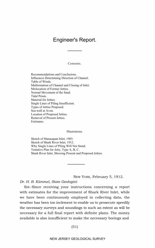
Engineer's Report.
Contents.
Recommendations and Conclusions.Influences Determining Direction of Channel.Table of Winds.Malformation of Channel and Closing of Inlet.Mislocation of Former Jetties.Normal Movement of the Sand.Tidal Prism.Material for Jetties.Single Lines of Piling Insufficient.Types of Jetties Proposed.Sea-wall at Avon.Location of Proposed Jetties.Removal of Present Jetties. Estimates.
Illustrations.
Sketch of Manasquan Inlet, 1903.Sketch of Shark River Inlet, 1912.Why Single Lines of Piling Will Not Stand.Tentative Plan for Jetty, Type A, B, C.Shark River Inlet, Showing Present and Proposed Jetties.
NEW YORK, February 5, 1912.Dr. H. B. Kümmel, State Geologist:
SIR―Since receiving your instructions concerning a reportwith estimates for the improvement of Shark River Inlet, whilewe have been continuously employed in collecting data, theweather has been too inclement to enable us to prosecute speedilythe necessary surveys and soundings to such an extent as will benecessary for a full final report with definite plans. The moneyavailable is also insufficient to make the necessary borings and
(51)
NEW JERSEY GEOLOGICAL SURVEY
52 ADMINISTRATIVE REPORT.
complete plans. Nevertheless, the data collected have enabledme to arrive at a definite conclusion as to the proper method ofimprovement and to give a sufficient close estimate for presentpurposes. I am also able to report definitely the followingrecommendations:
RECOMMENDATIONS AND CONCLUSIONS.
Shark River Bay is a most attractive pleasure ground andthe only important considerable body of salt water for this pur-pose lying accessible to Asbury Park, Ocean Grove, BradleyBeach, Avon, Belmar, Lake Como and Spring Lake, with theirlarge summer population. The bay also affords opportunitiesfor fine oyster grounds about one thousand acres in extent. Inorder to preserve it in suitable condition for the raising ofoysters and clams and other marine life, and to preserve itsattractiveness as a pleasure ground, the inlet must be kept openso as to admit the tides freely. This inlet is also the first oppor-tunity afforded south of Sandy Hook, twenty miles distant,where a haven is possible as a refuge for small sailing vesselsand motor boats. For these several reasons, the expenditurenecessary to maintain the inlet appears to be abundantly justi-fied.
The jetties which have been heretofore constructed in aneffort to maintain the inlet, have not been located on lines whichaccord with the natural tendency of the channel through thebeach and off shore. The lines of these jetties are so placed thatat present they seriously jeopardize the inlet and recently theyhave been the cause of a threatened closing of the same. Thesejetties have also been of entirely too light construction to beserviceable against the action of the sea.
The natural tendency of the channel is clearly indicated andis briefly, first, to deflect northward in a curve just inside thebeach, and then deflect eastward and southeasterly through thebeach and off shore. This tendency is due mainly to the in-fluence of the prevailing winds and other well-defined naturalforces. Channels occasionally open in a northeasterly or easterlydirection due to the action of storms, but such channels are
NEW JERSEY GEOLOGICAL SURVEY
IMPROVEMENT OF SHARK RIVER INLET. 53
unreliable and more or less transient, and the works should beplanned with a view to preventing such opening and with thepurpose of maintaining the channel in its natural southeasterlycourse through the beach and offshore.
The construction of light and cheap works is not economical.Whatever is to be done in the nature of improvement, must bethoroughly substantial, otherwise the money spent will bewasted. My studies indicate that jetties on the convex side ofa curving channel are unnecessary and that the southerly jettythrough the beach has usually proven an obstruction and worsethan useless. This conclusion leads me to put almost the entireexpense in a jetty at the northerly side through the beach, andenables me to build much more substantially, without increaseof the total cost. Tentatively I have adopted the types of con-struction shown in the accompanying plans, varying the strengthand cost per foot with the exposure of the jetty. The exact typeof construction to be followed, ultimately, must be adopted afterthe necessary borings have been obtained, and the offshore depthsand direction of the currents more accurately ascertained thanhas thus far been possible.
The estimates hereinafter detailed show that adequate workscannot be constructed for less than $58,000, and if, after trial,further extension seaward shall prove desirable, $13,476 addi-tional will be needed. Any reduction of this amount will belikely to jeopardize the entire investment.
The foregoing conclusions are based upon the facts which Ishall hereinafter set forth more in detail.
INFLUENCES DETERMINING DIRECTION OF CHANNEL.
The principal influence which determines the direction of thechannel off shore and through the beach is the wind. It is gen-erally well known that during the summer months the wind fromabout 11 A. M. until sunset is southeasterly. It is not south-easterly during the entire summer as many suppose, and indeedit is in this direction not more than one-third of the whole timeduring the six months from April to September, inclusive. Inorder to determine more accurately the direction of the wind, I
NEW JERSEY GEOLOGICAL SURVEY
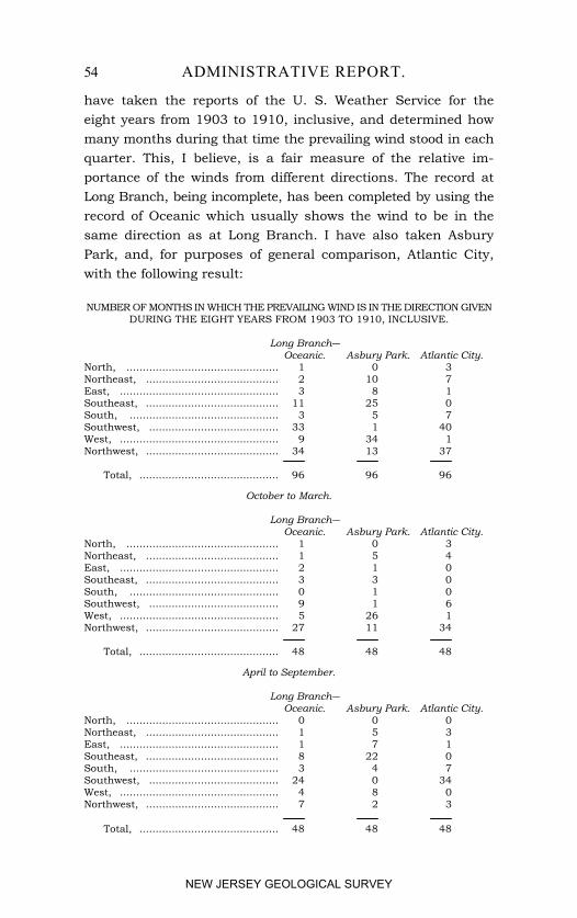
54 ADMINISTRATIVE REPORT.
have taken the reports of the U. S. Weather Service for theeight years from 1903 to 1910, inclusive, and determined howmany months during that time the prevailing wind stood in eachquarter. This, I believe, is a fair measure of the relative im-portance of the winds from different directions. The record atLong Branch, being incomplete, has been completed by using therecord of Oceanic which usually shows the wind to be in thesame direction as at Long Branch. I have also taken AsburyPark, and, for purposes of general comparison, Atlantic City,with the following result:
NUMBER OF MONTHS IN WHICH THE PREVAILING WIND IS IN THE DIRECTION GIVENDURING THE EIGHT YEARS FROM 1903 TO 1910, INCLUSIVE.
Long Branch―Oceanic. Asbury Park. Atlantic City.
North, ............................................... 1 0 3Northeast, ......................................... 2 10 7East, ................................................. 3 8 1Southeast, ......................................... 11 25 0South, .............................................. 3 5 7Southwest, ........................................ 33 1 40West, ................................................. 9 34 1Northwest, ......................................... 34 13 37
Total, ........................................... 96 96 96
October to March.
Long Branch―Oceanic. Asbury Park. Atlantic City.
North, ............................................... 1 0 3Northeast, ......................................... 1 5 4East, ................................................. 2 1 0Southeast, ......................................... 3 3 0South, .............................................. 0 1 0Southwest, ........................................ 9 1 6West, ................................................. 5 26 1Northwest, ......................................... 27 11 34
Total, ........................................... 48 48 48
April to September.
Long Branch―Oceanic. Asbury Park. Atlantic City.
North, ............................................... 0 0 0Northeast, ......................................... 1 5 3East, ................................................. 1 7 1Southeast, ......................................... 8 22 0South, .............................................. 3 4 7Southwest, ........................................ 24 0 34West, ................................................. 4 8 0Northwest, ......................................... 7 2 3
Total, ........................................... 48 48 48
NEW JERSEY GEOLOGICAL SURVEY
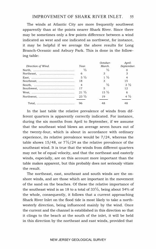
IMPROVEMENT OF SHARK RIVER INLET. 55
The winds at Atlantic City are more frequently southwestapparently than at the points nearer Shark River. Since theremay be sometimes only a few points difference between a windindicated as west and one indicated as northwest, for instance,it may be helpful if we average the above results for LongBranch-Oceanic and Asbury Park. This is done in the follow-ing table:
October- April- Direction of Wind. Year. March. September.North, ............................................... ½ ½ 0Northeast, ........................................ 6 3 3East, ................................................ 5 ½ 1 ½ 4Southeast, ......................................... 18 3 15South, .............................................. 4 ½ 3 ½ Southwest, ........................................ 17 5 12West, ................................................. 21 ½ 15 ½ 6Northwest, ......................................... 23 ½ 19 4 ½
Total, ........................................... 96 48 48
In the last table the relative prevalence of winds from dif-ferent quarters is apparently correctly indicated. For instance,during the six months from April to September, if we assumethat the southeast wind blows an average seven hours out ofthe twenty-four, which is about in accordance with ordinaryexperience, its relative prevalence would be 7/24, whereas thetable shows 15/48, or 7½/24 as the relative prevalence of thesoutheast wind. It is true that the winds from different quartersmay not be of equal velocity, and that the northeast and easterlywinds, especially, are on this account more important than thetable makes apparent, but this probably does not seriously vitiatethe result.
The northeast, east, southeast and south winds are the on-shore winds, and are those which are important in the movementof the sand on the beaches. Of these the relative importance ofthe southeast wind is as 18 to a total of 33½, being about 54% ofthe whole, consequently, it follows that a current approachingShark River Inlet on the flood tide is most likely to take a north-westerly direction, being influenced mainly by the wind. Oncethe current and the channel is established in this direction so thatit clings to the beach at the south of the inlet, it will be heldin this direction by the northeast and east winds, provided that
NEW JERSEY GEOLOGICAL SURVEY
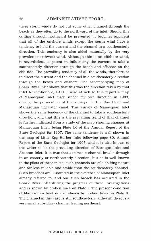
56 ADMINISTRATIVE REPORT.
these storm winds do not cut some other channel through thebeach as they often do to the northward of the inlet. Should thiscutting through northward be prevented, it becomes apparentthat all of the onshore winds except the south wind have atendency to hold the current and the channel in a southeasterlydirection. This tendency is also aided materially by the veryprevalent northwest wind. Although this is an offshore wind,it nevertheless is potent in influencing the current to take asoutheasterly direction through the beach and offshore on theebb tide. The prevailing tendency of all the winds, therefore, isto direct the current and the channel in a southeasterly directionthrough the beach and offshore. The accompanying map ofShark River Inlet shows that this was the direction taken by thatinlet November 22, 1911. I also attach to this report a mapof Manasquan Inlet made under my own direction in 1903,during the prosecution of the surveys for the Bay Head andManasquan tidewater canal. This survey of Manasquan Inletshows the same tendency of the channel to take a southeasterlydirection, and that this is the prevailing trend of that channelis further indicated from a study of the map showing changes atManasquan Inlet, being Plate IX of the Annual Report of theState Geologist for 1907. The same tendency is well shown inthe map of Little Egg Harbor Inlet following page 80, AnnualReport of the State Geologist for 1905, and it is also known tothe writer to be the prevailing direction of Barnegat Inlet andAbsecon Inlet. It is true that at times a channel breaks throughin an easterly or northeasterly direction, but as is well knownto the pilots of these inlets, such channels are of a shifting natureand far less reliable and stable than the southeasterly channel.Such breaches are illustrated in the sketches of Manasquan Inletalready referred to, and one such breach has occurred in theShark River Inlet during the progress of these investigationsand is shown by broken lines on Plate I. The present conditionof Manasquan Inlet is also shown by broken lines on Plate II.The channel in this case is still southeasterly, although there is avery small subsidiary channel leading northeast.
NEW JERSEY GEOLOGICAL SURVEY
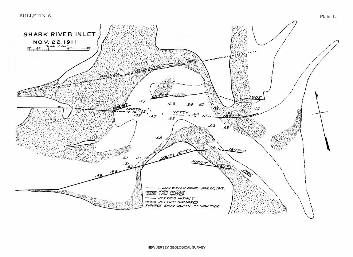
NEW JERSEY GEOLOGICAL SURVEY
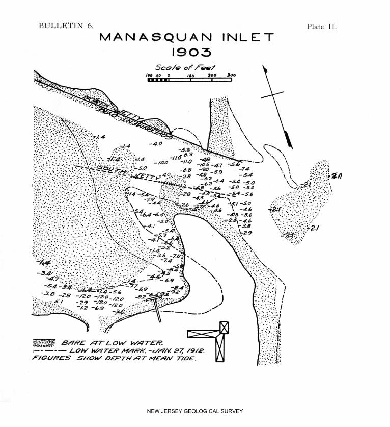
NEW JERSEY GEOLOGICAL SURVEY
IMPROVEMENT OF SHARK RIVER INLET. 57
Shark River and Manasquan Inlets both show similar tend-encies to the formation of an S-shape bend just inside the lineof the beach. The channel approaches the beach and then turnsby a curve northeasterly and then in its best condition almostimmediately turns again to the southeast, passing through thebeach. This is well shown in the preceding maps of the twoinlets. This tendency is due largely to the drift of the beachsand northeasterly during the prevailing southeasterly orsoutherly winds. However, it is well known that no runningstream remains in a stable condition with its channel in a straightline. The natural tendency is always to curve and only in acurved shape does it preserve anything like real stability. Thereason is that the current is deflected to the outside of the curveor the concave bank and the channel tends to assume a permanentposition somewhere between the middle of the stream and saidconcave bank. For this reason, it appears to me that this tend-ency as well as the southeasterly trend of the channel throughthe beach and off shore should be respected and any proposedjetties should conform to said tendency.
MALFORMATION OF CHANNEL AND CLOSING OF INLET.
The studies of both Shark River Inlet and Manasquan Inletshow similar tendencies toward deformation of the foregoingtype of channel, which type appears to most nearly approachnatural stability. First, the channel cuts into both of its con-cave banks. At the southerly bend of the S it will be noted thatat both inlets there is a tendency to cut into the beach in asoutheasterly or easterly direction, while at the northerly bendthere is a similar tendency to cut in a direction parallel withthe beach northerly and sometimes northeasterly toward thebeach. Both of these tendencies are injurious to stability forthe reason that the channel is broadened unduly by such cuttingand bars form, which increase the instability of the main chan-nel. Furthermore, the northeasterly bay frequently cuts to sucha depth that a northeasterly storm will drive entirely over thebeach into the channel, cutting away the beach and opening a
NEW JERSEY GEOLOGICAL SURVEY
58 ADMINISTRATIVE REPORT.
new inlet. This sometimes opens almost as far north as theline of Garfield avenue, at Avon, and the opening of such asecond inlet so divides the volume of water passing out to sea,that it is insufficient to keep either inlet open and both ultimatelyclose, causing the evils which we are now attempting to remedy.These tendencies immediately suggest the adoption of protectionworks at the concave banks of the inlet, which will prevent thecutting southeasterly at the southerly curve and the cutting north-easterly at the northerly curve of the S.
MISLOCATION OF FORMER JETTIES.
The foregoing explanation of the natural tendencies of theinlet will, I think, make clear one of the reasons for the failureof works heretofore constructed. Both the jetties of 1897 and1898 at Shark River and the jetties at Manasquan Inlet haveattempted to direct the channel in a direction nearly east, or alittle south of east. The jetties have been wide apart inshoreand have converged uniformly toward the inlet at the line ofthe beach. Two jetties have been built in all cases. The inlethas not conformed to these jetties for the reason that they didnot adapt themselves to its natural tendencies, or to any conditionwhich would enable it to adopt a stable course. An examinationof the accompanying maps will show that the southerly bulk-head has usually obtruded itself more or less directly across thepath of the southeasterly channel on the line of the beach, andhas proven a real obstruction rather than a help. At SharkRiver Inlet it has been an obstruction in this respect, and hasbeen of no service whatever. Inshore, at the southerly bend ofthe S, it was not substantial enough to prevent the stream follow-ing its natural tendencies, washing under the line of the jetty andcarrying away the planking. Through the line of the beach itoffered no protection whatever for the reason that the naturaltendency of the beach is to move northward, and, therefore, itneeds no protection against the scour of the channel. Furthereast the bulkhead has, as I said before, obtruded itself into thechannel and proven itself a serious obstruction. The north jettyat Shark River was also too unsubstantial to prevent the inlet
NEW JERSEY GEOLOGICAL SURVEY

IMPROVEMENT OF SHARK RIVER INLET. 59
from following its natural tendency to cut northward. Further-more, the jetty was not on proper lines to enable the stream tofollow it smoothly and harmlessly, consequently, the part of thejetty just inshore for some five hundred feet, is totally wrecked.The portion of the north jetty which remains standing throughthe beach, has become a menace as will be noted by reference tothe broken lines which show that this part of the jetty reallyaided the cutting through of the new channel during January,1912. It is also true that the jetty of 1905, or such small partsof it as still remain, likewise aided this cutting through of thebeach.
At Manasquan Inlet, the main channel refused entirely to re-main within the converging jetties and followed its natural ten-dency to an S-shape bend as already described, as well as itsnatural tendency to proceed through the beach and offshore ina southeasterly direction. The result has been that the southjetty has been totally wrecked and only small traces of it remain.The north jetty has proven to be of considerable value at Man-asquan, although an examination of the changes shows that theshifting of the S-shape bend is very great and often results inpractically closing the inlet. A study of this inlet makes it per-fectly clear that the jetty work would have been far more service-able if it had conformed to the natural tendencies of the channelas hereinbefore described.
NORMAL MOVEMENT OF THE SAND.
We have seen that the prevailing onshore winds are south-easterly and these winds result in driving the waves diagonallyonto the beach with a general northerly direction and set the sandsteadily toward the north, up the beach. So long as these windsprevail, therefore, the sand on the beach at the southerly side ofthe inlet is steadily creeping toward the inlet and on the floodtide, this sand from the south side is carried in the inlet untilit is deposited where the current slackens. On the ebb tide, thissand is again carried out, but as soon as it reaches the ocean, itis deposited at the northeasterly side of the inlet, where it con-tinues its northerly movement along the beach, although the
NEW JERSEY GEOLOGICAL SURVEY
60 ADMINISTRATIVE REPORT.
deposit from the inlet usually forms a more or less extended barimmediately at the northeast side. Northeasterly storms may attimes drive part of this sand back into the inlet, but if the latteris confined to a fixed location, it is hoped that this difficulty willbe speedily overcome when the wind veers again to the south-east, northwest, or west. If not, then the jetty must be extendedsome 300 feet further into the ocean, or beyond the edge of thepresent bar, so that the increased depth and current will move thesand more rapidly northward. The necessity for this extensionmust be determined either by further soundings and currentobservations, or by experiment. The slow movement of the sandfrom the southerly beach toward the inlet will be counteractedby the natural scour of the inlet, bearing in mind that thenortherly jetty will prevent any bodily movement of the inletnorthward.
TIDAL PRISM.
Our ability to maintain a sufficient inlet depends in largemeasure upon the volume of water passing through it at eachtide. By computing this volume, and comparing it with Man-asquan Inlet at times of approximate stability, we should be ableto estimate approximately the width and depth of the resultinginlet through the beach. Our levels show that, adopting meantide at Sandy Hook as our datum, the comparative levels ofordinary high and low water are as follows:
- E l e v a t i o n i n F e e t . -High Tide. Low Tide.
Ocean, ..................................................... 2.35 -2.35Inside of beach, ........................................ 1.96 -1.04Upper bay, ............................................... 1.70 -0.70
These levels show that the mean range of the tide in the oceanis 4.70 feet, while just inside the beach it is 3.00 feet, and in theupper bay 2.40 feet. They also show that while high tide in theupper bay is .65 feet lower than in the ocean, low tide is 1.65feet higher in the upper bay than in the ocean. As a result, thetide flows out about one and one-quarter to one and one-halfhours longer than it flows inward to the bay. In other words,
NEW JERSEY GEOLOGICAL SURVEY
IMPROVEMENT OF SHARK RIVER INLET. 61
flood tide continues about three-quarters of an hour after hightide in the ocean and the outflow continues about two hours afterlow tide in the ocean. Inasmuch as an equal amount of watergoes in and comes out, or practically so, the result is that the floodtide into the bay runs stronger than the ebb tide, as it mustnecessarily do in order to pass in the same quantity of water ina shorter period of time. The velocity at flood tide is said to be asmuch as five miles per hour, but I believe much of the time itmaterially exceeds this.
The following figures for Manasquan River and Shark Rivershow the relative volume of the tidal prism for each, togetherwith the average volume of the fresh-water outflow. It will beseen that the latter is comparatively insignificant as against thevolume of water due to the tides.
Manasquan SharkRiver. River.
Water surface, acres, ....................................................... 1,216 1,018Range of tide, feet, .......................................................... 2.50 2.40Tidal prism, acre-feet, ...................................................... 3,040 2,443Mean discharge of fresh water per tide, acre-feet, ........... 135 30Total average outflow each tide, acre-feet, ........................ 3,175 2,473
The foregoing table shows that the volume of water passingthrough Shark River Inlet is practically eighty per cent, of thatpassing through Manasquan Inlet. Manasquan Inlet was shownby our surveys to be 320 feet wide at mean tide, with a depthranging from 4.4 to 6.4 feet, and a cross-sectional area of 1,380square feet. By analogy, Shark River Inlet should have an areaof cross section of 1,104 square feet at mean tide and if properlyconfined to one location as is proposed, I estimate its probablewidth to be 200 feet, and mean depth 5 feet 6 inches. Its widthat times may be reduced to 150 feet and its depth near the pro-posed jetty will probably be about 7 feet at mean tide, and 5 feetat low tide. It appears, therefore, that the tidal prism shouldbe sufficient to maintain an adequate channel through the beach.If this channel is maintained in a stable condition, the tidal prismis likely to increase somewhat, which will be favorable to in-creased width and depth of the inlet.
NEW JERSEY GEOLOGICAL SURVEY
62 ADMINISTRATIVE REPORT.
MATERIALS FOR JETTIES.
My estimates show that there will not be any great differencein cost between proper, substantial jetties built of timber andfilled with stone, and jetties built of reinforced concrete amplybraced. If hard wood could be obtained for piling and sheetpiling, its lasting properties would be entirely satisfactory.There is a considerable amount of piling at present in place atShark River Inlet, which was put down more than twenty-fiveyears ago, and which is still in fairly good condition. How-ever, hard wood is extremely scarce, and if any of the softerwood are used it becomes absolutely necessary that they shall betreated with creosote. With such treatment, we may expectsufficient durability for practical purposes from the timber itself.A serious difficulty arises, however, in the case of timber struc-tures, from the corrosion of iron spikes and bolts, which are in-dispensable for their construction. Such iron fastenings corroderapidly in sea water and such corrosion eventually leads to theirdestruction. Inasmuch as there is no substantial difference ineconomy, therefore, I am at present of the opinion thatreinforced concrete is the better material. Timber might beused by driving two lines of piling with sheet piling, pumpingout the sand between, and running into the enclosed space asolid wall of concrete of a thickness of not less than four feet.In this case the timber would be temporary, and its entire de-struction would leave the concrete amply strong to answer thepurpose. Further investigation may prove that for a part ofthe work a construction along these lines will be useful andeffective, and it may be adopted without changing the estimates.The present estimates, however, are based upon the use of rein-forced concrete piling, intended to be cast in wooden molds andtransported to and used on the work after setting sufficiently tobe handled.
I am emphatically of the opinion that only a rich mixture ofcement and sand should be used in this work. My own experi-ence in hydraulic work has convinced me of the great superiorityof mixtures of one part cement and two parts sand, in density,
NEW JERSEY GEOLOGICAL SURVEY
IMPROVEMENT OF SHARK RIVER INLET. 63
imperviousness to water and general resistence to disintegra-tion Elaborate experiments conducted by a committee ap-pointed by the Scandinavian Portland Cement Manufacturersconvinced said committee that a mixture of one part cement tothree parts sand would disintegrate in sea water, and a mixtureof one part cement to two parts sand was recommended. Inview of all experience at hand, therefore, I should consider itunwise to adopt a mixture less rich than one to two, especiallyfor reinforced concrete work. I have also investigated the pos-sibility of getting gravel for the concrete from the gravel pitswithin hauling distance of Shark River Inlet, and it appears tobe possible to get gravel of a proper size and quality to be usedfor this purpose at a cost of not exceeding $1.50 per cubic yarddelivered on the work. The cost of crushed trap rock will heconsiderably higher and will probably not be much less than$2.75 per cubic yard on the work. Since the gravel is not onlycheaper, but has less voids, and therefore calls for a less volumeof sand and cement mortar, its use will result in a very con-siderable economy in the cost of concrete, and this will be truewhether it is used alone or mixed with broken stone. Thebeach sand which is found in abundance immediately at hand,will be suitable for use in the concrete, and since the cost ofcement at present is low, conditions are favorable to concrete oflow cost even though it be made as rich in cement as one totwo. Results from the use of suitable gravel have been entirelysatisfactory, and I should not hesitate to permit its use in thiscase.
SINGLE LINES OF PILING INSUFFICIENT.
Why the light pile jetties heretofore adopted have proven in-sufficient is illustrated by the drawing inserted herewith. In thiscase, I have assumed piling 25 feet long with walling pieces oftimber bolted on above low tide, and sheet piling 20 feet longdriven along the face and spiked to the aforesaid walling pieces.I have also assumed the usual condition, namely, a channel aboutfive feet deep at low tide normally, but which has been washedout by the eddies and currents along the face of the jetty to a
NEW JERSEY GEOLOGICAL SURVEY
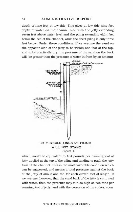
64 ADMINISTRATIVE REPORT.
depth of nine feet at low tide. This gives at low tide nine feetdepth of water on the channel side with the jetty extendingseven feet above water level and the piling extending eight feetbelow the bed of the channel, while the sheet piling is only threefeet below. Under these conditions, if we assume the sand onthe opposite side of the jetty to be within one foot of the top,and to be practically dry, the pressure of the sand on the backwill be greater than the pressure of water in front by an amount
which would be equivalent to 184 pounds per running foot ofjetty applied at the top of the piling and tending to push the jettytoward the channel. This is the most favorable condition whichcan be suggested, and means a total pressure against the backof the jetty of about one ton for each eleven feet of length. Ifwe assume, however, that the sand back of the jetty is saturatedwith water, then the pressure may run as high as two tons perrunning foot of jetty, and with the corrosion of the spikes, soon
NEW JERSEY GEOLOGICAL SURVEY
IMPROVEMENT OF SHARK RIVER INLET. 65
becomes sufficient to force the planking or sheet piling off of thejetty, and indeed to force the piling out and destroy the structure.Destruction sometimes occurs also by the washing out of the bedof the channel below the bottom of the sheet piling, and this,combined with the pressure of the saturated sand at the back,quickly strips off the sheet piling and destroys the jetty. Wherethe jetty is exposed to the action of the waves of the sea, destruc-tion is, of course, much more rapid. Such structures are entirelyinadequate, and are, for the purpose, by no means worth themoney which it cost to construct them. Even with the substan-tial jetties which I propose, I consider it to be important to protectthe jetty on the channel side from unusual scour by placing stoneor riprap in the bottom of the channel for about eight feet outfrom the face of the jetty, first taking the precaution to pump outthe sand so that the top of the stone will be at a depth of not lessthan five feet at low tide. This riprap protection will add mate-rially to the durability and stability of the structure.
TYPES OF JETTIES PROPOSED.
After due consideration, I have tentatively adopted three typesof concrete jetties for the purposes of this estimate. These areshown in the accompanying drawings, and will be referred to astypes A, B and C, respectively. Further surveys and especiallyborings, which are imperatively necessary in order to locate thedepth of the sand and the nature of the underlying material, saidto be hard pan, but which more probably consists of clay-marl,may lead to some modification of these types. The types are allbased on the use of a reinforced concrete sheet pile, measuringsixteen inches thick by twenty-four inches wide, and containinga tongue and a groove for the purposes of holding it in line withthe adjoining pile. In the absence of borings, I have been com-pelled to assume an average length for the piling, in type A andtype B jetties, of twenty-five feet. The piles will be cast hollowin order to reduce the weight, as shown by the cross-section.They will be reinforced longitudinally by three-quarter inch steelrods, and traversely with number six wire. It is intended that
5 AD
NEW JERSEY GEOLOGICAL SURVEY
66 ADMINISTRATIVE REPORT.
they shall be cast in suitable molds, allowed to set, and thentransported to the work and sunk by means of a jet of water, inwhich operation the hollow form will probably prove very con-venient. The mixture used in making concrete for these pileswill consist of one part cement, two parts beach sand, and eitherfour parts of broken trap rock, or five parts of gravel and traprock or gravel alone.
Type A jetty will consist of two lines of these concrete sheetpiles, placed about ten feet apart. After the piles are driven,reinforced concrete caps or string pieces will be cast in place,including a cross beam or tie every ten feet to tie the two linesof piling together. After completion, sand will be pumped infrom the channel to fill the space between the piling to the topin order to increase the weight and stability. The sand will bepumped out on the channel side as previously suggested, andstone or riprap will be placed to the amount of one cubic yardto each running foot of jetty, the surface of the stone being keptfive feet below low-water mark. Type A jetty is intended tobe used for about 200 feet on the end of the north jetty, where itprojects through and beyond the line of the beach and is con-siderably exposed to the pounding of the waves.
Type B is to be adopted for the jetties along the northerlyand southerly curves of the S formed by the channel just insidethe beach, where considerable strength and solidity is required,but where the jetty is less exposed than is the case with Type A.
Type B consists of a single line of the previously describedconcrete sheet piling, driven as previously described and supple-mented by similar brace piles driven ten feet distant from thesheet piling. The tops of these brace piles will be at about thelevel of low tide. A cap or string piece will be cast along thetops of the sheet piling and at the same time a cross piece orbrace of the form shown by the drawings will be cast, reachingfrom this string backward to the brace piles, the whole suitablyreinforced with steel rods. As there will be no circulation ofwater permitted at the rear of these jetties, it is expected thatthe rear space will naturally within a short time fill up with sand,but in order to add stability to the jetty before this filling takes
NEW JERSEY GEOLOGICAL SURVEY
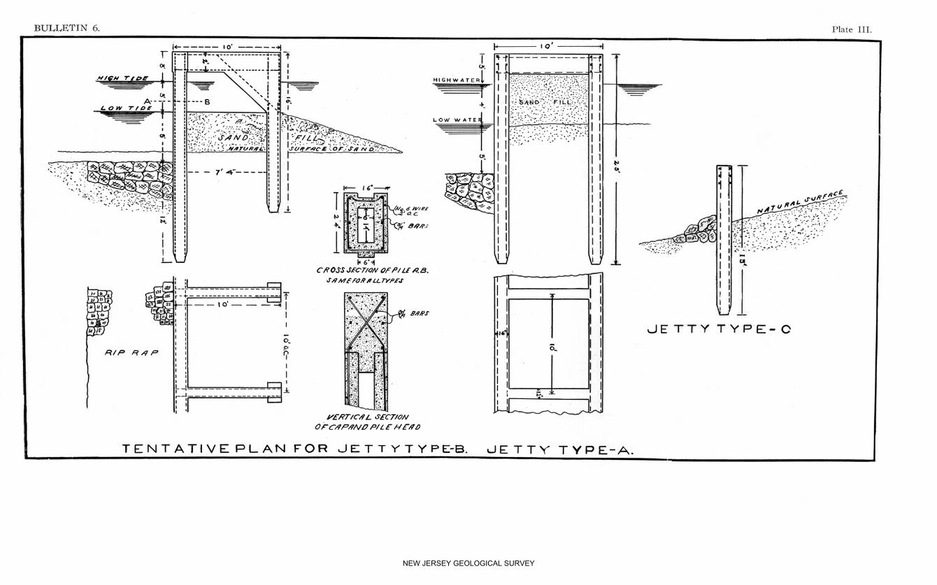
NEW JERSEY GEOLOGICAL SURVEY
IMPROVEMENT OF SHARK RIVER INLET. 67
place, it is intended that sand shall be pumped from the channelover to the rear of the jetty, filling it up to about the level oflow tide. Riprap will be placed along the channel side of thejetty as described in the case of type A.
Type C is a lighter form of jetty which will extend along thenortherly bank of the inlet from the end of the heavier jettyat the S bend, westerly to the line of Second Avenue in Avon.Since this is the convex side of the channel throughout, it isnot expected that there will be any scour along the face of thisjetty, and its principal purpose is to prevent the water frombreaking over back of the north jetty and washing away thesand during times of unusual high tides.
SEA WALL AT AVON.
In order to prevent the channeling out of the sand on the rearor northerly side of the jetty, I propose a short spur jetty run-ning about 200 feet up the beach from the line of the north jetty.It will add considerably to the stability of this beach betweenthe north jetty and the fast land in Avon, if a sea wall of somekind can be built reaching from the north jetty northward tothe line of Garfield Avenue, at the boardwalk. This beach islow and there is a chance that at times it may be cut out by theaction of northeasterly or easterly storms. Such storms will notbe able to make a permanent breach so long as the inlet is con-trolled by the jetties, and is not allowed to cut northerly insideof the beach as it has done heretofore; but if such inroads ofthe waves from the ocean can be prevented entirely, the stabilityof the whole work will he materially increased. It has beensuggested that the construction of the proposed ocean boulevard,which would naturally traverse about the same line as the sug-gested bulkhead or sea wall, will give all of the protection neces-sary at this point. I believe this to be true and have not includedthe cost of such a sea wall in my present estimates. Indeed, Ido not believe that an expensive structure will be necessary.
NEW JERSEY GEOLOGICAL SURVEY
68 ADMINISTRATIVE REPORT.
LOCATION OF PROPOSED JETTIES.
As is shown by the accompanying sketch, the northerly jettystarts at the line of Second Avenue and runs along the northerlybank of the inlet nearly straight for the first 475 feet, thenceby a curve to the left with a radius of 300 feet to a total distanceof 850 feet from Second Avenue. This portion is all of typeC. The north jetty thence continues by a curve of 450 feetradius to the right, a distance of 600 feet to the beach, this por-tion being of type B and being joined at its easterly end by thespur jetty previously alluded to. From the line of this spur jettythe main jetty continues southeasterly 250 feet, being of type Aand extending some 200 feet into the ocean beyond the line ofthe beach.
The south jetty starts at the angle of the present bulkhead atBelmar, at the south side of the inlet and just to the west of thecontinuation of A Street. Thence it continues easterly by acurve to the left with a radius of 500 feet for a distance of 475feet. This is all of the south jetty which it is intended to con-struct, and its purpose is to overcome the tendency of the inletto cut southeasterly into the beach and also to confine it to aposition consistent with stability. This south jetty will be en-tirely of type B. As heretofore stated, it is not continued aroundthe northerly end of the beach at Belmar, for the reason that thenatural tendency of this beach is to move northward, so thatit suffers no probable danger from cutting away. Furthermore,it is my purpose to permit the inlet at this point to assume itsown natural cross section, simply confining it in location by thenortherly jetty. If a south jetty is built, it is impossible at thepresent time to foresee accurately just what its distance shall befrom the north jetty. If it is built too far distant from thenorth jetty, the sand will accumulate beyond it to the north andthe jetty will, therefore, become absolutely useless. On the otherhand, if it is built too close to the north jetty, and the waterwaythereby abnormally contracted, the range of tide in the bay islikely to be materially decreased so that the volume of water pass-ing in and out at each tide will be diminished and the size and
NEW JERSEY GEOLOGICAL SURVEY
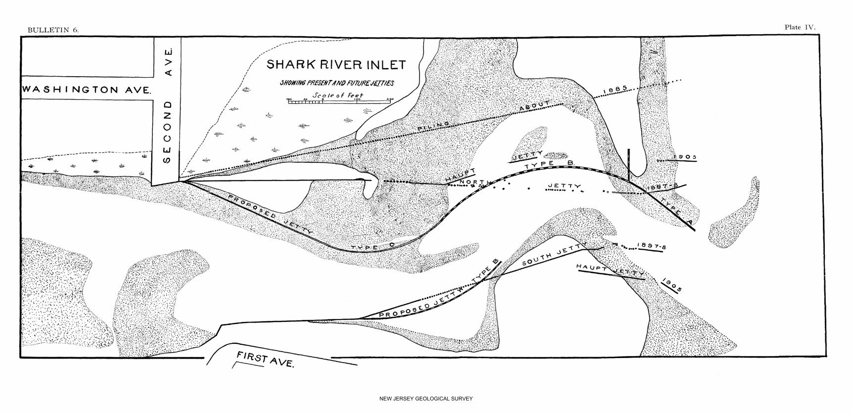
NEW JERSEY GEOLOGICAL SURVEY
IMPROVEMENT OF SHARK RIVER INLET. 69
depth of the inlet will be correspondingly reduced. Consequently,I can see nothing but harm to come from the construction of thesoutherly jetty, and I believe that the money which it wouldcost would serve a much more useful purpose if applied to in-creasing the strength and stability of the northerly jetty.
The current in the inlet will be naturally driven toward thenorth-curved jetty by the action of the prevailing southeasterlywind as well as by the encroachment of the sand of the beachat the south, and will, therefore, naturally assume a width anddepth most conducive to stability, and I believe will result inmaintaining a better opening of inlet than any other systemwhich can be devised.
REMOVAL OF PRESENT JETTIES.
I have already referred to the harmful tendencies of the presentjetties, due to the fact that they are out of alignment with thenatural tendency of the channel. These jetties, therefore, shouldbe entirely removed where they are between the lines of thejetties now proposed, and the ends of the southerly jetties wherethey now- extend beyond low-water mark should also be removed.
ESTIMATES.
I estimate that the cost of concrete in the molds, using brokentrap rock and a mixture of one, two and four, will be $5.73per cubic yard net, allowing no profit to the contractor. Thecost of concrete using gravel and a mixture of one, two and five,will be $4.50 per cubic yard net, and the cost of a concrete com-posed of a mixture of gravel and broken stone and proportionsone, two and five, will be $5.2o per cubic yard, net. Makingsome allowance for incidentals, I have called the net cost 20c. percubic foot, or $5.40 per cubic yard, which does not include thecost of forms or molds, or the cost of steel reinforcement.
The cost of a concrete pile 1 foot 4 inches x 2 feet x 25 feetcontaining 53 cubic feet will be as follows:
6AD
NEW JERSEY GEOLOGICAL SURVEY
70 ADMINISTRATIVE REPORT.53 cu. ft. of concrete in place @ 20c., ............................................. $10 60Cost of mold used 12 times, per pile, ............................................. 1 50Steel rods and wire, 350 lbs. @ 2c., ............................................... 7 00Interior mold, ................................................................................. 2 00Placing steel reinforcement, ........................................................... 40
Net cost of pile, ......................................................................... $21 50
Cost per lineal foot of pile, 86c.Cost of brace pile 10 ft. long @ 86c. per lineal foot, ......................... $8 60
Reinforced concrete cross beam, Type B:36 cu. ft. of concrete @ 20c., ............................................ $7 20Forms, ............................................................................ 4 80Steel reinforcement, 175 lbs., @ 2c., ................................. 3 50
$15 50
Reinforced concrete cross beam, Type A, in place:15 cu. ft. of concrete @ 20c., ............................................ $3 00Forms, ............................................................................ 3 00Steel reinforcement, 76 lbs. @ 2c., ................................... 1 52
$7 52
Reinforced concrete cap or string piece in place, per foot:2.67 cu. ft. concrete @ 20c., ............................................. $0 5413 lbs. steel reinforcement @ 2c., .................................... 26Forms ............................................................................. 35
Total per lineal foot, .............................................................. $1 15
Cost of a 10 ft. bent of jetty, Type A:10 reinforced concrete piles 25 ft. long @ $21.50, ............ $215 00Handling and driving piles @ $5 each, ............................ 50 00One cross beam, ............................................................. 15 5020 ft. of cap or string piece @ $1.15, ................................ 23 0025 cu. yds. of sand fill @ 25c., . ....................................... 6 2510 cu. yds. of riprap @ $2.50, ......................................... 25 00
Net cost of 10 ft. bent, ........................................................... $334 75Net cost of jetty per foot=$33.48.
Cost of 10 ft. bent of jetty, Type B:5 reinforced concrete piles @ $21.50, .............................. $107 50One brace pile 10 ft. long @ 86c., ................................... 8 60Handling and driving six piles @ $5, ............................... 30 0010 ft. of cap or string piece @ $1.15, ............................... 11 5020 cu. yds. of sand fill @ 25c., ........................................ 5 0010 cu. yds. of riprap @ $2.50, ......................................... 25 00
Net cost of 10 ft. bent, ............................................................ $187 60Net cost per foot of jetty, $18.76.
Cost of jetty, Type C, per foot:Reinforced concrete pile 13 ft. long @ 86c. per lineal foot $11.18 for 2 feet of jetty=per foot, ................................ $5 59One foot of cap or string piece, ........................................ 1 15½ cu. yd. of riprap @ $2.50, ............................................. 1 25½ cu. yd. of sand fill @ 25c., ............................................ 13Handling and driving piles, .............................................. 2 50
Net cost of jetty per foot, ......................................................... $10 62
NEW JERSEY GEOLOGICAL SURVEY
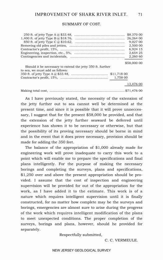
IMPROVEMENT OF SHARK RIVER INLET. 71
SUMMARY OF COST.
250 ft. of jetty Type A @ $33.48, ................................................... $8.370 001,400 ft. of jetty Type B @ $18.76, .................................................. 26,264 00 850 ft. of jetty Type C @ $10.62, .................................................. 9,027 00Removing old piles and jetties, ........................................................ 2,500 00Contractor's profit, 15%, ................................................................. 6,924 15Engineering, inspection, etc., 5%, ................................................... 2,654 25Contingencies and incidentals, ....................................................... 2,260 60
$58,000 00Should it be necessary to extend the jetty 350 ft. further
to sea, we must add as follows:350 ft. of jetty Type A @ $33.48, ..................................... $11,718 00Contractor's profit, 15%, ................................................ 1,758 00
13,476 00
Making total cost, ............................................................................ $71,476 00
As I have previously stated, the necessity of the extension ofthe jetty further out to sea cannot well be determined at thepresent time, and since it is possible that it will prove unnecces-sary, I suggest that for the present $58,000 be provided, and thatthe extension of the jetty further seaward be deferred untilexperience has shown it to be necessary or otherwise, but thatthe possibility of its proving necessary should be borne in mindand in the event that it does prove necessary, provision should bemade for adding the 350 feet.
The balance of the appropriation of $1,000 already made forengineering work will prove inadequate to carry this work to apoint which will enable me to prepare the specifications and finalplans intelligently. For the purpose of making the necessaryborings and completing the surveys, plans and specifications,$1,250 over and above the present appropriation should be pro-vided. I assume that the cost of inspection and engineeringsupervision will be provided for out of the appropriation for thework, as I have added it to the estimate. This work is of anature which requires intelligent supervision until it is finallyconstructed, for no matter how complete may be the surveys andborings, emergencies are almost sure to arise during the progressof the work which requires intelligent modification of the plansto meet unexpected conditions. The proper completion of thesurveys, borings and plans, however, should he provided forseparately.
Respectfully submitted, C. C. VERMEULE.
NEW JERSEY GEOLOGICAL SURVEY
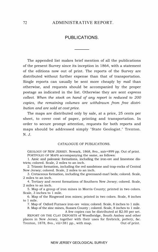
72 ADMINISTRATIVE REPORT.
PUBLICATIONS.
The appended list makes brief mention of all the publicationsof the present Survey since its inception in 1864, with a statementof the editions now out of print. The reports of the Survey aredistributed without further expense than that of transportation.Single reports can usually be sent more cheaply by mail thanotherwise, and requests should be accompanied by the properpostage as indicated in the list. Otherwise they are sent expresscollect. When the stock on hand of any report is reduced to 200copies, the remaining volumes are withdrawn from free distri-bution and are sold at cost price.
The maps are distributed only by sale, at a price, 25 cents persheet, to cover cost of paper, printing and transportation. Inorder to secure prompt attention, requests for both reports andmaps should be addressed simply "State Geologist." Trenton.N. J.
CATALOGUE OF PUBLICATIONS.
GEOLOGY OF NEW JERSEY. Newark, 1868, 8vo., xxiv+899 pp. Out of print.PORTFOLIO OF MAPS accompanying the same, as follows:1. Azoic and paleozoic formations, including the iron-ore and limestone dis-
tricts; colored. Scale, 2 miles to an inch.2. Triassic formation, including the red sandstone and trap-rocks of Central
New Jersey; colored. Scale, 2 miles to an inch.3. Cretaceous formation, including the greensand-marl beds; colored. Scale,
2 miles to an inch.4. Tertiary and recent formations of Southern New Jersey; colored. Scale,
2 miles to an inch.5. Map of a group of iron mines in Morris County; printed in two colors.
Scale, 3 inches to 1 mile.6. Map of the Ringwood iron mines; printed in two colors. Scale, 8 inches
to 1 mile.7. Map of Oxford Furnace iron-ore veins; colored. Scale, 8 inches to 1 mile.8. Map of the zinc mines, Sussex County ; colored. Scale, 8 inches to 1 mile.
A few copies can be distributed at $2.00 per set.REPORT ON THE CLAY DEPOSITS of Woodbridge, South Amboy and other
places in New Jersey, together with their uses for firebrick, pottery, &c.Trenton, 1878, 8vo., viii+381 pp., with map. Out of print.
NEW JERSEY GEOLOGICAL SURVEY
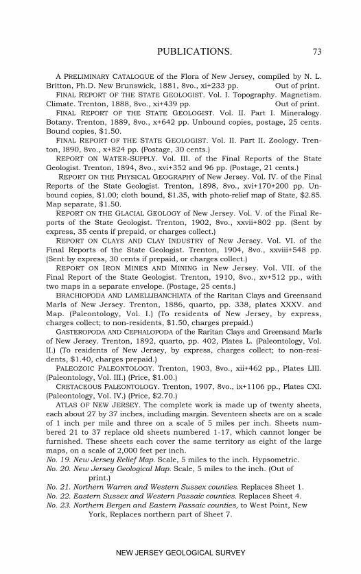
PUBLICATIONS. 73
A PRELIMINARY CATALOGUE of the Flora of New Jersey, compiled by N. L.Britton, Ph.D. New Brunswick, 1881, 8vo., xi+233 pp. Out of print.
FINAL REPORT OF THE STATE GEOLOGIST. Vol. I. Topography. Magnetism.Climate. Trenton, 1888, 8vo., xi+439 pp. Out of print.
FINAL REPORT OF THE STATE GEOLOGIST. Vol. II. Part I. Mineralogy.Botany. Trenton, 1889, 8vo., x+642 pp. Unbound copies, postage, 25 cents.Bound copies, $1.50.
FINAL REPORT OF THE STATE GEOLOGIST. Vol. II. Part II. Zoology. Tren-ton, I890, 8vo., x+824 pp. (Postage, 30 cents.)
REPORT ON WATER-SUPPLY. Vol. III. of the Final Reports of the StateGeologist. Trenton, 1894, 8vo., xvi+352 and 96 pp. (Postage, 21 cents.)
REPORT ON THE PHYSICAL GEOGRAPHY of New Jersey. Vol. IV. of the FinalReports of the State Geologist. Trenton, 1898, 8vo., xvi+170+200 pp. Un-bound copies, $1.00; cloth bound, $1.35, with photo-relief map of State, $2.85.Map separate, $1.50.
REPORT ON THE GLACIAL GEOLOGY of New Jersey. Vol. V. of the Final Re-ports of the State Geologist. Trenton, 1902, 8vo., xxvii+802 pp. (Sent byexpress, 35 cents if prepaid, or charges collect.)
REPORT ON CLAYS AND CLAY INDUSTRY of New Jersey. Vol. VI. of theFinal Reports of the State Geologist. Trenton, 1904, 8vo., xxviii+548 pp.(Sent by express, 30 cents if prepaid, or charges collect.)
REPORT ON IRON MINES AND MINING in New Jersey. Vol. VII. of theFinal Report of the State Geologist. Trenton, 1910, 8vo., xv+512 pp., withtwo maps in a separate envelope. (Postage, 25 cents.)
BRACHIOPODA AND LAMELLIBANCHIATA of the Raritan Clays and GreensandMarls of New Jersey. Trenton, 1886, quarto, pp. 338, plates XXXV. andMap. (Paleontology, Vol. I.) (To residents of New Jersey, by express,charges collect; to non-residents, $1.50, charges prepaid.)
GASTEROPODA AND CEPHALOPODA of the Raritan Clays and Greensand Marlsof New Jersey. Trenton, 1892, quarto, pp. 402, Plates L. (Paleontology, Vol.II.) (To residents of New Jersey, by express, charges collect; to non-resi-dents, $1.40, charges prepaid.)
PALEOZOIC PALEONTOLOGY. Trenton, 1903, 8vo., xii+462 pp., Plates LIII.(Paleontology, Vol. III.) (Price, $1.00.)
CRETACEOUS PALEONTOLOGY. Trenton, 1907, 8vo., ix+1106 pp., Plates CXI.(Paleontology, Vol. IV.) (Price, $2.70.)
ATLAS OF NEW JERSEY. The complete work is made up of twenty sheets,each about 27 by 37 inches, including margin. Seventeen sheets are on a scaleof 1 inch per mile and three on a scale of 5 miles per inch. Sheets num-bered 21 to 37 replace old sheets numbered 1-17, which cannot longer befurnished. These sheets each cover the same territory as eight of the largemaps, on a scale of 2,000 feet per inch. No. 19. New Jersey Relief Map. Scale, 5 miles to the inch. Hypsometric.No. 20. New Jersey Geological Map. Scale, 5 miles to the inch. (Out of
print.)No. 21. Northern Warren and Western Sussex counties. Replaces Sheet 1.No. 22. Eastern Sussex and Western Passaic counties. Replaces Sheet 4.No. 23. Northern Bergen and Eastern Passaic counties, to West Point, New
York, Replaces northern part of Sheet 7.
NEW JERSEY GEOLOGICAL SURVEY
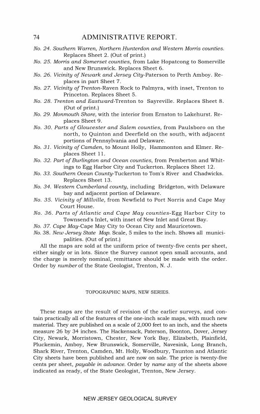
74 ADMINISTRATIVE REPORT.No. 24. Southern Warren, Northern Hunterdon and Western Morris counties. Replaces Sheet 2. (Out of print.)No. 25. Morris and Somerset counties, from Lake Hopatcong to Somerville and New Brunswick. Replaces Sheet 6.No. 26. Vicinity of Newark and Jersey City-Paterson to Perth Amboy. Re- places in part Sheet 7.No. 27. Vicinity of Trenton-Raven Rock to Palmyra, with inset, Trenton to Princeton. Replaces Sheet 5.No. 28. Trenton and Eastward-Trenton to Sayreville. Replaces Sheet 8.
(Out of print.)No. 29. Monmouth Shore, with the interior from Ernston to Lakehurst. Re- places Sheet 9.No. 30. Parts of Gloucester and Salem counties, from Paulsboro on the north, to Quinton and Deerfield on the south, with adjacent portions of Pennsylvania and Delaware.No. 31. Vicinity of Camden, to Mount Holly, Hammonton and Elmer. Re- places Sheet 11.No. 32. Part of Burlington and Ocean counties, from Pemberton and Whit- ings to Egg Harbor City and Tuckerton. Replaces Sheet 12.No. 33. Southern Ocean County-Tuckerton to Tom's River and Chadwicks. Replaces Sheet 13.No. 34. Western Cumberland county, including Bridgeton, with Delaware bay and adjacent portion of Delaware.No. 35. Vicinity of Millville, from Newfield to Port Norris and Cape May Court House.No. 36. Parts of Atlantic and Cape May counties-Egg Harbor City to Townsend's Inlet, with inset of New Inlet and Great Bay.No. 37. Cape May-Cape May City to Ocean City and Mauricetown.No. 38. New Jersey State Map. Scale, 5 miles to the inch. Shows all munici- palities. (Out of print.)
All the maps are sold at the uniform price of twenty-five cents per sheet,either singly or in lots. Since the Survey cannot open small accounts, andthe charge is merely nominal, remittance should be made with the order.Order by number of the State Geologist, Trenton, N. J.
TOPOGRAPHIC MAPS, NEW SERIES.
These maps are the result of revision of the earlier surveys, and con-tain practically all of the features of the one-inch scale maps, with much newmaterial. They are published on a scale of 2,000 feet to an inch, and the sheetsmeasure 26 by 34 inches. The Hackensack, Paterson, Boonton, Dover, JerseyCity, Newark, Morristown, Chester, New York Bay, Elizabeth, Plainfield,Pluckemin, Amboy, New Brunswick, Somerville, Navesink, Long Branch,Shark River, Trenton, Camden, Mt. Holly, Woodbury, Taunton and AtlanticCity sheets have been published and are now on sale. The price is twenty-fivecents per sheet, payable in advance. Order by name any of the sheets aboveindicated as ready, of the State Geologist, Trenton, New Jersey.
NEW JERSEY GEOLOGICAL SURVEY
PUBLICATION 75
GEOLOGIC ATLAS OF NEW JERSEY.
The State Geological Survey, in co-operation with the U. S. GeologicalSurvey, is engaged in the publication of a Geologic Atlas of New Jersey. Itwill be issued in several parts, each part containing a complete discussion ofthe geography and geology for the region covered. Each volume will com-prise (1) pages of descriptive text, (2) a topographic map, (3) geologic mapsshowing the distribution and structure of the various rock formations, theoccurrence of all mineral deposits of economic importance, and (4) in somecases pages of half-tone illustrations. The following folios are now ready:
THE PASSAIC FOLIO, which covers the region from Morristown toJersey City, and from Perth Amboy and New Brunswick to Pompton andWestwood, comprising 945 square miles; scale, 2 miles to an inch. It includes27 pages of text, a topographic map, 3 geologic maps and a page of illustra-tions. Price, 25 cents; postage, 15 cents; if sent by express, charges collect.
THE FRANKLIN FOLIO covers the territory from Branchville and New-ton, on the west, to Stockholm on the east, and from Andover and Peters-burg, on the south, to Libertyville on the north, or 235 square miles; scale, 1inch to a mile. In addition to the regular text and maps it includes a specialstudy and description of the famous zinc deposits at Franklin Furnace, and ofthe white crystalline limestones. Price, 25 cents; postage, 15 cents extra; ifsent by express, charges collect.
THE PHILADELPHIA FOLIO covers parts of New Jersey and Penn-sylvania adjacent to Philadelphia. It is a double folio (scale, 1 inch per mile),having four topographic maps, four geologic maps, two maps showing, bymeans of cross sections, the geological structure and the relation of thevarious rock formations to each other below the surface, a page of illustra-tions and twenty-four pages of descriptive text. Price, 50 cents; postage, 15cents extra; if sent by express, charges collect.
THE TRENTON FOLIO describes the region around Trenton as far asStockton, Millstone, Hightstown, New Egypt, Mount Holly, Delanco andNewtown, Pa., an area of 911 square miles. It contains descriptive text andthree maps (scale, 2 miles per inch), It is published in two forms, the foliosize (213/4 by 181/2 inches) and a pocket or octavo size (91/4 by 6 inches). Inthe latter the maps are on thin paper, are folded and in a pocket. This sizeis more convenient for field use than the folio size. Price, folio edition, 25cents, postage is 15 cents extra; pocket edition, 50 cents, postage 10 centsextra. If sent by express, charges collect.
Other folios will be prepared and issued from time to time until the entireState is covered.
Orders for these folios should be addressed to the State Geologist, Trenton,N. J., and remittance must accompany the order.
NEW JERSEY GEOLOGICAL SURVEY
76 ADMINISTRATIVE REPORT.
ANNUAL REPORTS.
REPORT OF PROFESSOR GEORGE H. COOK upon the Geological Survey of NewJersey and its progress during the year 1863. Trenton, 1864, 8vo., 13 pp.
Out of print.THE ANNUAL REPORT of Prof. Geo. H. Cook, State Geologist, to his Ex-
cellency Joel Parker, President of the Board of Managers of the GeologicalSurvey of New Jersey, for the year 1864. Trenton, 1865, 8vo., 24 pp.
Out of print.ANNUAL REPORT of Prof. Geo. H. Cook, State Geologist, to his Excellency
Joel Parker, President of the Board of Managers of the Geological Survey ofNew Jersey, for the year 1865. Trenton, 1866, 8vo., 12 pp. Out of print.
ANNUAL REPORT of Prof. Geo. H. Cook, State Geologist, on the GeologicalSurvey of New Jersey, for the year 1866. Trenton, 1867, 8vo., 28 pp.
Out of print.REPORT OF THE STATE GEOLOGIST, Prof. Geo. H. Cook, for the year of 1867.
Trenton, 1868, 8vo., 28 pp. Out of print.ANNUAL REPORT of the State Geologist of New Jersey for 1869. Trenton
1870, 8vo., 57 pp., with maps. Out of print.ANNUAL REPORT of the State Geologist of New Jersey for 1870. New
Brunswick, 1871, 8vo., 75 pp., with maps. Out of print.ANNUAL REPORT of the State Geologist of New Jersey for 1871. New
Brunswick, 1872, 8vo., 46 pp., with maps. Out of print.ANNUAL REPORT of the State Geologist of New Jersey for 1872. Trenton,
1872, 8vo., 44 pp., with map. Out of print.ANNUAL REPORT of the State Geologist of New Jersey for 1873. Trenton,
1874, 8vo., 128 pp., with maps. Out of print.ANNUAL REPORT of the State Geologist of New Jersey for 1874. Trenton,
1874, 8vo., 115 pp. Out of print.ANNUAL REPORT of the State Geologist of New Jersey for 1875. Trenton,
1875, 8vo., 41 pp., with map. Out of print.ANNUAL REPORT of the State Geologist of New Jersey for 1876. Trenton,
1876, 8vo., 56 pp., with maps. Out of print.ANNUAL REPORT of the State Geologist of New Jersey for 1877. Trenton,
1877, 8vo., 55 pp. Out of print.ANNUAL REPORT of the State Geologist of New Jersey for 1878. Trenton,
1878, 8vo., 131 pp., with map. Out of print.ANNUAL REPORT of the State Geologist of New Jersey for 1879. Trenton,
1879, 8vo., 199 pp., with maps. Out of printANNUAL REPORT of the State Geologist of New Jersey for 1880. Trenton,
1880, 8 vo., 220 pp., with map. Out of print.ANNUAL REPORT of the State Geologist of New Jersey for 1881. Trenton,
1881, 8vo., 87+107+xiv. pp., with maps. Out of print.ANNUAL REPORT of the State Geologist of New Jersey for 1882. Camden,
1882, 8vo., 191 pp., with maps. Out of print.ANNUAL REPORT of the State Geologist of New Jersey for 1883. Camden,
1883, 8vo., 188 pp. (Price, 50 cents.)ANNUAL REPORT of the State Geologist of New Jersey for 1884. Trenton,
1884, 8vo., 168 pp., with maps. (Postage, 8 cents.)
NEW JERSEY GEOLOGICAL SURVEY
PUBLICATIONS. 77
ANNUAL REPORT of the State Geologist of New Jersey for 1885. Trenton.1885, 8vo., 228 pp., with maps. (Postage, 9 cents.)
ANNUAL REPORT of the State Geologist of New Jersey for 1886. Trenton1887, 8 vo., 254 pp., with maps. (Postage, 9 cents.)
ANNUAL REPORT of the State Geologist of New Jersey for 1887. Trenton,1887, 8vo., 45 pp., with maps. (Postage, 5 cents.)
ANNUAL REPORT of the State Geologist of New Jersey for 1888. Camden,1889, 8vo., 87 pp., with map. (Postage, 5 cents.)
ANNUAL REPORT of the State Geologist of New Jersey for 1889. Camden.1889, 8vo., 112 pp. (Postage, 6 cents.)
ANNUAL REPORT of the State Geologist of New Jersey for 1890. Trenton,1891, 8vo., 305 pp., with maps. (Postage, 10 cents.)
ANNUAL REPORT of the State Geologist of New Jersey for 1891. Trenton,1892, 8vo., xii+270 pp., with maps. Out of print.
ANNUAL REPORT of the State Geologist of New Jersey for 1892. Trenton,1893, 8vo., x+368 pp., with maps. (Price, $1.55.)
ANNUAL REPORT of the State Geologist of New Jersey for 1893. Trenton,1894, 8vo., x+452 pp., with maps. (Postage, 18 cents.)
ANNUAL REPORT of the State Geologist of New Jersey for 1894. Trenton,1895, 8vo., x+304 pp., with geological map. (Postage, 11 cents.)
ANNUAL REPORT of the State Geologist of New Jersey for 1895. Trenton,1896, 8vo., xl+198 pp., with geological map. (Postage, 8 cents.)
ANNUAL REPORT of the State Geologist of New Jersey for 1896. Trenton,1897, 8vo., xxviii+377 pp., with map of Hackensack meadows. (Postage, 15cents.)
ANNUAL REPORT of the State Geologist of New Jersey for 1897. Trenton,1898, 8vo., xl+368 pp. (Postage, 12 cents.)
ANNUAL REPORT of the State Geologist for 1898. Trenton, 1899, 8vo.,xxxii+244 pp., with Appendix, 102 pp. (Postage, 14 cents.)
ANNUAL REPORT of the State Geologist for 1899 and REPORT ON FORESTS.Trenton, 1900, 2 vols., 8vo., Annual Report, xliii+192 pp. FORESTS, xvi+327pp., with seven maps in a roll. (Postage, 8 and 22 cents,)
ANNUAL REPORT of the State Geologist for 1900. Trenton, 1901, 8vo., xl+231 pp. (Postage, 10 cents.)
ANNUAL REPORT of the State Geologist for 1901. Trenton, 1902, 8vo.,xxviii+178 pp., with one map in pocket. (Postage, 10 cents.)
ANNUAL REPORT of the State Geologist for 1902. Trenton, 1903, 8vo.,viii+155 pp. (Postage, 6 cents.)
ANNUAL REPORT of the State Geologist for 1903. Trenton, 1904, 8vo.,xxxvi+132 pp., with two maps in pocket. (Price, 40 cents.)
ANNUAL REPORT of the State Geologist for 1904. Trenton, 1905, 8vo.,x+317 pp. (Postage, 12 cents.)
ANNUAL REPORT of the State Geologist for 1905. Trenton, 1906, 8vo-,x+338 pp., with three maps in a pocket (Price, 55 cents.)
ANNUAL REPORT of the State Geologist for 1906. Trenton, 1907, 8vo.,vii+192 pp. (Postage, 10 cents.)
ANNUAL REPORT of the State Geologist for 1907. Trenton, 1908, 8vo.,ix+192 pp. (Postage, 12 cents.)
NEW JERSEY GEOLOGICAL SURVEY
78 ADMINISTRATIVE REPORT.ANNUAL REPORT of the State Geologist for I908. Trenton, 1909, 8vo.,
xi+159 pp. (Postage, 8 cents.)ANNUAL REPORT of the State Geologist for 1909. Trenton, 1910, 8vo.,
vii+123 pp. (Postage, 6 cents.)
BULLETINS.
In 1910 the series of Annual Reports was replaced by a series of Bulletins,each being a separate report upon some subject. Up to date five Bulletinshave been issued.
BULLETIN 1.―Administrative Report of the State Geologist of New Jerseyfor 1910. Trenton, 1911, 43 pp. (Out of print.)
BULLETIN 2.―A Report on the Approximate Cost of a Canal between BayHead and the Shrewsbury River, by H. B. Kümmel. Trenton, 1911, 20 pp.,1 map.
BULLETIN 3.―The Flora of the Raritan Formation, by Edward W. Berry.Trenton, 1911, v+233 pp. and xxix plates.
BULLETIN 4.―A Description of Fossil Fish Remains of the Cretaceous,Eocene and Miocene Formations of New Jersey, by Henry W. Fowler.Trenton, 1911, 192 pp.
BULLETIN 5.―The Mineral Industry of New Jersey for 1910, by H. B.Kümmel and S. Percy Jones. Trenton, 1911, 24 pp.
NEW JERSEY GEOLOGICAL SURVEY
INDEX.
A.
Page.Administration, ................................................................................ 7American Mining Congress, meeting of, ............................................ 41Appropriation for Survey, .................................................................. 8Asbury Park, direction of winds at, ................................................... 54Association of State Geologists, ......................................................... 40Atlantic City, description of bench mark at, ...................................... 20 direction of winds at, ................................................... 54Avon, need of sea wall at, .................................................................. 67
B.
Bench marks, determinations of 1886 and 1911 compared, .............. 19 need of additional, ...................................................... 21Berry, E. W., report by, on Raritan plant remains, ............................ 21Bitumen and oil, testing of, for roadmaking, ..................................... 38Board of Managers, changes in, ........................................................ 9 list of, ................................................................ 3Bulletins, list of, ............................................................................... 78 publication of, ................................................................... 10
C.
Cape May Court House, description of bench mark at, ...................... 20Clinton, probable water supply from deep wells near, ........................ 30Coastal stability versus coastal subsidence, ...................................... 31Concrete mixture for jetties, .............................................................. 62Cook, George H., views of, on coastal subsidence, ............................. 31Co-operative work, ............................................................................ 39Cretaceous formations, fish remains in, ............................................ 24
E.
Eocene formations, fish remains in, .................................................. 24Expenditures of Survey, .................................................................... 8
F.
Fish remains, report on, .................................................................... 24
(79)
NEW JERSEY GEOLOGICAL SURVEY
80 INDEX.G.
Page.Gage, R. B., work by, on oil and bitumen for road making, ................ 38Geologic atlas, folios described, ......................................................... 75Geologic work, progress of, ............................................................... 21Green Pond Mountain belt, described, ............................................... 35
J.Jetties, concrete mixture for piles, ..................................................... 66 material for, .......................................................................... 62Johnson, D. W., studies by, on Atlantic coast changes, ...................... 33
K.Kümmel, H. B., report by, on water supply near Clinton, .................... 29
L.Leveling, report on, ............................................................................ 18Library, size and additions to, ............................................................ 11Long Branch-Oceanic, direction of winds at, ....................................... 54
M.Manasquan Inlet, condition of, .................................................... 56, Pl. II mislocation of jetties at, .................................................. 59 Inlet and Shark River Inlet, similarity between, ............... 57 River and Shark River, relative volume of tidal prism for, 61Maps, distribution and cost, ............................................................10, 72 sale of, in 1910, ...................................................................... 11 topographic, new series of, ...................................................... 74Mine Safety Demonstration Meeting, .................................................. 42Mineral production for 1910, ............................................................. 26Miocene formations, fish remains in, ................................................. 24
N.New Jersey Geological Survey, when organized, ................................. 41New York State, studies of Green Pond Mountain belt in, ................... 36Note taking, system of, ...................................................................... 13
O.Oil and bitumen, testing of, for road making, ..................................... 38Organization of Survey, ...................................................................... 9
P.Plant remains, report on, by E. W. Berry, ........................................... 21Property of Survey, classes of, ............................................................ 12 system of keeping records of, ............................................... 12
NEW JERSEY GEOLOGICAL SURVEY
INDEX. 81
Page.Publications of Survey, classes of, ...................................................... 10 distribution of, .............................................................10, 72 in 1910, ......................................................................... 10 list of, ............................................................................ 72
R.Raritan clays, report on plant remains of, .......................................... 21 flora, geographical distribution of, ......................................... 24 origin of, ...................................................................... 24 formation, clays and sands of, .............................................. 22 distribution of, ..................................................... 21 flora of, ................................................................ 23 plant remains of, ................................................. 22Rays, remains of, ............................................................................... 24
S.Shark River and Manasquan River, relative volume of tidal prism for, .. 61Shark River Inlet, breach at, ......................................................... 56, Pl. I direction of winds at, ...................................................... 53 effect of wind on channel at, ........................................ 53, 55 influences determining channel of, ................................. 53 malformation of channel and closing of inlet, .................. 57 map of, ....................................................................... Pl. I, II normal movement of sand at, .......................................... 59 tidal range at, ................................................................ 60 tidal prism for, ............................................................ 60, 61 velocity of flood tide at, ............................................... 61Shark River Inlet and Manasquan Inlet, similarity between, ....... 57Shark River Inlet Improvement, chairman's report to Board of Mana- gers, .................................................................. 49 cost of gravel for concrete, ....................................... 63 cost of trap rock for concrete, .................................. 63 estimates of cost, ......................................................... 69 engineer's report to Board of Managers, ................ 51 location of proposed jetties, ......................................... 68 materials for jetties, ...................................................... 62 mislocation of former jetties, ....................................... 58 necessity of double lines of piling, ................. 63, 64, Fig. 3 need of sea wall at Avon, ................................................. 67 recommendations and conclusions, .............................. 52 removal of present jetties, ............................................. 69 report by the Board of Managers, .............................. 47 summary of cost, .......................................................... 71 types of jetties proposed, ...................................... 65, Pl. III use of jetties, ................................................................. 53
NEW JERSEY GEOLOGICAL SURVEY
82 INDEX.
Page.Sharks, remains of, ........................................................................... 24Soil analyses, .................................................................................... 38Soil investigations, ............................................................................ 37State institutions, wells at, ................................................................ 27Survey staff, ...................................................................................... 9
T.Topographic work, progress of, .......................................................... 18
U.Underground water supply near Clinton, ........................................... 30
V.Vermeule, C. C., report on leveling, .................................................... 18 report on Shark River Inlet improvement, ................. 51
W.Well records, collection of data, .......................................................... 27Wells at State institutions, ................................................................. 27Winds, effect on channels at various inlets, ........................................ 56Woman's Reformatory, report on water supply available for, ............... 28
NEW JERSEY GEOLOGICAL SURVEY