Embed Size (px)
Citation preview
1
HENLEAZE, STOKE BISHOP & WESTBURY-ON-TRYM NEIGHBOURHOOD PARTNERSHIP
TRANSPORT SUB-GROUP
Report of: Service Director – Transport Service.
Title: RS13012 (H125) – Coldharbour Road zebra crossing.
Officer presenting report: Rob Grieve, Principal Officer, Highways and Traffic, Transport Service.
Contact Telephone Number: (0117) 92 23695
OFFICER COMMENTS
The report highlights the preferred location for a zebra crossing and a consultation plan has been produced. RECOMMENDATION
1. To proceed to public consultation.
CH2M Hill
1 The Square Temple Quay Bristol BS1 6DG
Tel +44 (0)117 910 2580 Fax +44 (0)117 910 2581
www.ch2mhill.com
Technical Note
Registered office: Elms House 43 Brook Green London W6 7EF. Registered in England and Wales. Registered number 3415971
Project Bristol City Council
RS13012 (IB102) Coldharbour Road, Henleaze
Date 24 February 2014
Note Summary of Pedestrian Crossing Location Investigation
Ref 203742.BL.00.37-015
Status Final Revision Number 1 Author Darren Cox Approved Paul Bufton
1. Introduction
1.1 Bristol City Council commissioned CH2M Hill to undertake a feasibility study to determine a safe location for a pedestrian crossing across Coldharbour Road, close to Cairns Road, in Henleaze.
1.2 Following the introduction, this Technical Note is structured as follows:
• Section 2 – Background;
• Section 3 – Potential Locations Considered;
• Section 4 – Design Options
• Section 5 – Accident Data;
• Section 6 – Recommendation;
• Section 7 – Preliminary Design Options;
• Section 8 – Indicative Costs; and
• Section 9 – Summary.
2. Background
2.1 Coldharbour Road spans the ward boundary between Henleaze and Redland. It is a very busy road that is a two-way bus route and is used by heavy vehicles as well as cars and cyclists. Traffic speed builds up on the downhill section from the traffic signals at the Linden Road junction and those at the Springfield Grove/Bishop Road junction.
2.2 Local Sustainability Transport Grant (LSTF) funds were applied for, and secured, for the provision of a pedestrian crossing of Coldharbour Road to be located close to Cairns Road – the position to be determined after a traffic assessment and a pedestrian count.
2.3 There is a desire for Henleaze residents to cross Coldharbour Road to access the shops on the south-east side and for families using the playgroups at Cairns Road Baptist Church, which also provides facilities for older people. It is potentially a desire line for young people travelling to primary schools in Henleaze as well as Bishop Road and Redland Green secondary schools.
Technical note Summary of Pedestrian Crossing Location Investigation
Page 2
Project
Bristol City Council RS13012 (IB102) Coldharbour Road, Henleaze
Ref 203742.BL.00.37-015
Registered office: Elms House 43 Brook Green London W6 7EF. Registered in England and Wales. Registered number 3415971
2.4 The project brief issued to CH2M Hill identified a zebra crossing as the preferred pedestrian crossing type.
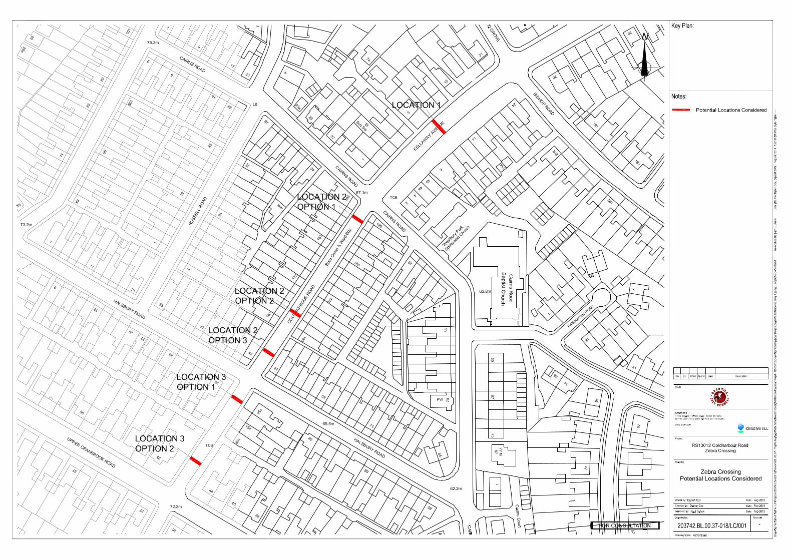
3. Potential Locations Considered
3.1 This section of the Technical Notes identifies and assesses the suitability of each of the locations considered for the zebra crossing. All locations considered are lit by a system of street lighting and are subject to a 30mph speed limit and are indicated on the plan appended to this technical note in Appendix A.
3.2 Kellaway Avenue (between its junctions with Springfiled Grove/Bishop Road and Cairns Road) – is approximately 10.9 metres in width. Its junction with Springfield Grove and Bishop Road is controlled by traffic signals that run an all red stage that provides controlled pedestrian crossing of all four arms.
3.3 Residential properties, the majority of which have dropped kerb vehicle crossovers providing access to off-street parking facilities, exist on the north-west side. A bus stop clearway (no stopping at any time except local buses) exists in the vicinity of numbers 13 to 19 inclusive and waiting at its south-west end is controlled by a no waiting at any time restriction around its junction with Cairns Road.
3.4 Uncontrolled parking exists between the dropped kerb vehicle crossovers, but parking opportunities are limited.
3.5 A rank of retail units exists on the south-east side and there are two dropped kerb vehicle crossovers providing access to private parking in front of the units. A bus stop clearway (no stopping at any time except local buses) exists in the vicinity of numbers 12 to 16 inclusive, including a bus shelter, and waiting at its south-west end is controlled by a no waiting at any time restriction, around its junction with Cairns Road.
3.6 Uncontrolled parking exists on Kellaway Avenue to the front of the retail units which appears to be very well used by customers and passing trade.
Technical note Summary of Pedestrian Crossing Location Investigation
Page 3
Project
Bristol City Council RS13012 (IB102) Coldharbour Road, Henleaze
Ref 203742.BL.00.37-015
Registered office: Elms House 43 Brook Green London W6 7EF. Registered in England and Wales. Registered number 3415971
3.7 Locating the proposed zebra crossing on this link, even at its south-westerly extent, places it within 100 metres of the existing controlled pedestrian facility at the junction of Kellaway Avenue and Springfield Grove/Bishop Road, which is considered to be an over provision in such a short length.
3.8 It also has the potential to adversely affect the operation of the Kellaway Avenue and Springfield Grove/Bishop Road junction. A high level of pedestrians crossing at this location could result in vehicles travelling south-west queuing back through the junction. The attention of drivers travelling north-east may be drawn to a green signal at the junction instead concentrating on pedestrians waiting, or crossing, at the zebra, to the detriment of highway safety.
3.9 There are few, if any, opportunities to site the proposed zebra on this link due to the existence of dropped kerb vehicle crossovers on both sides of the road and the potential requirement to relocate bus stops and associated infrastructure.
3.10 Mature trees are present at the front edge of the footway on both sides of Kellaway Avenue that could mask pedestrians waiting to use the zebra crossing and it is unlikely that Bristol City Council will permit their removal to facilitate a zebra crossing in this location.
3.11 The zig-zag carriageway markings required at the zebra will remove the limited parking opportunities between dropped kerb vehicle crossovers on the north-west side and, more importantly, remove the majority of parking opportunities on Kellaway Avenue in front of the retail units for customers and passing trade. This is likely to be very unpopular with residents, visitors and retailers.
3.12 For these reasons, it is no considered feasible to site the proposed zebra crossing in this location.
3.13 Coldharbour Road (between its junctions with Cairns Road and Halsbury Road) – is between 7.6 and 7.7 metres wide for its entire length. Terraced residential properties front both sides of the road for its entire length and uncontrolled parking exists on both sides, except at its north-eastern and south-western extents where its junctions are protected by a no waiting at any time restriction.
3.14 The properties on the north-west side have limited off-street parking opportunities to the rear, whereas a greater number of properties on the south-east side have garages to the rear and access to a rear garage court.
Technical note Summary of Pedestrian Crossing Location Investigation
Page 4
Project
Bristol City Council RS13012 (IB102) Coldharbour Road, Henleaze
Ref 203742.BL.00.37-015
Registered office: Elms House 43 Brook Green London W6 7EF. Registered in England and Wales. Registered number 3415971
3.15 During site visits, parking activities were observed on the north-west side only. Vehicles were observed parked on the south-east side but only for a short period of time. On each occasion, drivers felt it necessary to display their hazard warning lights and mount the footway such that two wheels were obstructing the footway with two wheels remaining on the carriageway. Such parking activities quickly reduced Coldharbour Road to single direction working with drivers relying on the goodwill of other drivers to allow them passage. This was exacerbated due to the number of large vehicles that use the road, including a frequent two-way bus service.
3.16 Option 1 – Local Transport Note 2/95 The Design of Pedestrian Crossings states that a zebra should not be located within an absolute minimum of 5 metres of an uncontrolled junction. The zebra crossing could be located at the end of the no waiting restriction to runs around the Coldharbour Road / Cairns Road junction, outside of number 189.
3.17 However, Coldharbour Road is formed of a vertical curve, the brow of which is towards its south-western end, in the general vicinity of numbers 164&166 and 167&169. A zebra crossing designed in accordance with the requirements of Chapter 5 of the Traffic Signs Manual requires an approximate length of 40 metres of carriageway.
Technical note Summary of Pedestrian Crossing Location Investigation
Page 5
Project
Bristol City Council RS13012 (IB102) Coldharbour Road, Henleaze
Ref 203742.BL.00.37-015
Registered office: Elms House 43 Brook Green London W6 7EF. Registered in England and Wales. Registered number 3415971
3.18 Surveys will be required to determine the 85th percentile of speed of traffic using Coldharbour Road, but it is unlikely that the detailed design of a zebra in this location will meet either the desirable minimum, or absolute minimum, visibility requirements for north-eastbound drivers, to the detriment of highway safety.
3.19 The required Belisha beacons may cause a nuisance to residents in the vicinity of the zebra crossing, especially during the hours of darkness, but this could be mitigated by installing shielding to the rear of the beacons.
3.20 A zebra in this location will also remove the majority of on-street parking opportunities on both sides of Coldharbour Road, increasing the pressure on the remaining on-street space which will be very unpopular with local residents who rely on the existing space.
3.21 A potential solution may be to remove the double yellow lines on Coldharbour Road at its junction with Cairns Road, and start the required zig-zag carriageway markings from this junction. This may achieve the required visibility should the surveys conclude that the 85th percentile of speed is 30mph or below.
3.22 It is unlikely that a localised reduction in the speed limit to 20mph in this location, thereby reducing the visibility requirements, will produce a significant reduction in speeds without rigorous enforcement.
3.23 Option 2 – would see the zebra positioned on the brow of the vertical curve. Whilst this option is likely to achieve the required visibility, the crossing itself will extend beyond the brow in both directions, reducing forward visibility to pedestrians, to their detriment.
3.24 The issue of the removal of the majority of on-street parking opportunities from both sides of Coldharbour Road applies as does the potential nuisance to residents from Belisha beacons.
3.25 It is unlikely that a localised reduction in the speed limit to 20mph in this location, thereby reducing the visibility requirements, will produce a significant reduction in speeds without rigorous enforcement.
3.26 Option 3 – would see the zebra positioned at the junction of Coldharbour Road and Halsbury Road. However, this will place the crossing point across the dropped kerb vehicle crossover associated with number 45 Halsbury Road, making it unfeasible.
3.27 Coldharbour Road (between its junctions with Halsbury Road and Upper Cranbrook Road) – is between 7.6 and 7.7 metres wide for its entire length. A no waiting at any time restriction exists on both sides of Coldharbour Road at its junction with Halsbury Road and a bus stop clearway (no stopping at any time except local buses) exists on the north-west side.
3.28 Limited on-street parking opportunities exist on both sides but, as only 4No. Residential properties each with off-street parking facilities to the rear front this length of Coldharbour Road, none were observed during any of the site visits.
Technical note Summary of Pedestrian Crossing Location Investigation
Page 6
Project
Bristol City Council RS13012 (IB102) Coldharbour Road, Henleaze
Ref 203742.BL.00.37-015
Registered office: Elms House 43 Brook Green London W6 7EF. Registered in England and Wales. Registered number 3415971
3.29 Dropped kerb accesses to a rear lane exist opposite one another at approximately the mid-point of this link.
3.30 Option 1 – is to position the zebra crossing to the north-east of the dropped kerb accesses. In order to ensure that the crossing itself is away from the access points, the no waiting at any time restriction will need to be revoked at the junction with Halsbury Road and the zebra zig-zag carriageway marking started at this junction.
3.31 Whilst the loss of the existing on-street parking provision will have little or no negative impact, the Belisha beacons may cause a nuisance to the residents of the four properties that front this section of Coldharbour Road.
3.32 Option 2 – is to locate the zebra south-west of the access points. This will require the relocation of the bus stop cage, clearway, flag and pole. The differences from Option 1 are: an increase in visibility for south-westbound drivers; and no nuisance to residents caused by Belisha beacons.
3.33 It is anticipated that both options will achieve the required visibility but places the zebra crossing close to the traffic signal controlled junction of Coldharbour Road and Linden Road that incorporates a controlled pedestrian crossing facility.
3.34 Whilst the provision of a zebra crossing in these two locations is technically feasible, both are sufficiently remote from the desire line to the shops and the facilities provided at the Baptist Church to not achieve the objectives of this study
3.35 For this reason, it is not considered feasible to install the proposed zebra crossing in either of these locations.
Technical note Summary of Pedestrian Crossing Location Investigation
Page 7
Project
Bristol City Council RS13012 (IB102) Coldharbour Road, Henleaze
Ref 203742.BL.00.37-015
Registered office: Elms House 43 Brook Green London W6 7EF. Registered in England and Wales. Registered number 3415971
4. Design Options
4.1 Given that preliminary investigations suggest that there MAY only be one location where a zebra crossing can be installed that meets the objectives of this study, we have undertaken further research into the detailed design of a zebra as well as considering the provision of a pedestrian refuge as an alternative crossing type to be installed on the desire line.
4.2 Zebra Crossing – a “standard” zebra crossing requires 8No. zig-zag carriageway markings on both the approach and exit in order to provide adequate visibility between driver and pedestrians. However, section 15.17 of Chapter 5 of the Traffic Signs Manual states:
“The aim should be to lay at least the standard pattern of eight 2 metre marks on both sides of the crossing. Where site constraints prevent this, the length of the zig-zag marks may be varied to a minimum of 1 metre and the number of marks reduced to a minimum of two. Zig-zag marks shorter than 2 metres should be used only to indicate a controlled area of fewer than eight marks. Even then marks as near as possible to the maximum 2 metres length should be provided, using a smaller number if necessary; each mark in each zig-zag line must be substantially the same length as the other marks in the same line.”
Chapter 5 Traffic Signs Manual: Table 15-1 Number of Zig-Zags
Length Available for the Marked Controlled Area (metres)
Recommended Number of Equal Length Zig-Zag Markings
2.750 – 4.500 2 4.500 – 6.500 3 6.500 – 9.000 4 9.000 – 11.000 5 11.000 – 13.000 6 13.000 – 15.500 7 15.500 – 17.585 8
“Notes:
1. The length indicated in the first column consists of the controlled area defined on figures 15-1 and 15-2, excluding the distance between the stop or give way line and the limit of the crossing;
2. Crossings must not be laid with fewer than two zig-zag marks; and
3. Where a length in the first column is common to two recommended numbers of marks, the lower number should be applied.”
4.3 The decision of whether to install a zebra crossing is dependent on the results of the speed survey. However, should the results conclude that the 85th percentile is suitable for the installation of a zebra crossing, a reduction in the length and/or number of zig-zag carriageway markings on both the approach and exit could be considered, but will require authorisation from appropriate Bristol City Council Officers and the detailed design will be the subject of a Stage 2 Road Safety Audit.
Technical note Summary of Pedestrian Crossing Location Investigation
Page 8
Project
Bristol City Council RS13012 (IB102) Coldharbour Road, Henleaze
Ref 203742.BL.00.37-015
Registered office: Elms House 43 Brook Green London W6 7EF. Registered in England and Wales. Registered number 3415971
4.4 Pedestrian Refuge – was considered as an alternative crossing type to be installed on the desire line.
4.5 We are aware that the desire line is for access to the shops and for families using the playgoups at Cairns Road Baptist Church, which also provides facilities for older people. Given the type of pedestrian who are likely to use the crossing, a refuge of a minimum width of 2 metres will be required to provide suitable protection to parents with a pushchair and disabled persons using a wheelchair.
4.6 The width of Coldharbour Road, in the vicinity of its junction with Cairns Road is 7.7 metres and the installation of a 2 metre wide refuge results in a running width of 2.85 metres in both directions, which will not only create a pinchpoint for cyclists, but is also insufficient on a two-way bus route that is also a popular route for larger vehicles.
4.7 For the reasons summarised above, the pedestrian refuge option will not be pursued.
5. Accident Data 5.1 A summary of the Personal Injury Accidents (PIAs) recorded on Kellaway Avenue
and Coldharbour Road, between the junctions with Springfield Grove & Bishop Road and Halsbury Road, in the three-year period 1 July 2010 and 30 June 2013, is provided in Table 5.1 below, by severity:
Table 5.1: Summary of Personal Injury Accidents
Street Name Severity Slight Serious Fatal
Kellaway Avenue / Springfield Grove / Bishop Road Junction 1 1 0 Bishop Road 1 0 0 Kellaway Avenue 1 1 0 Kellaway Avenue / Cairns Road Junction 1 0 0 Coldharbour Road / Halsbury Road Junction 1 0 0 Total 5 2 0
5.3 The summary table indicates that, between 1 July 2010 and 1 June 2013, there were a
total of 7 Personal Injury Accidents in the study area of which five (71%) resulted in slight injury and two (29%) resulted in serious injury. No fatal accidents were recorded.
5.4 We have read through the Police records of each of the 7 accidents and none involved pedestrians.
Technical note Summary of Pedestrian Crossing Location Investigation
Page 9
Project
Bristol City Council RS13012 (IB102) Coldharbour Road, Henleaze
Ref 203742.BL.00.37-015
Registered office: Elms House 43 Brook Green London W6 7EF. Registered in England and Wales. Registered number 3415971
6. Recommendation
6.1 The recommendations of this initial Technical Note are two-fold:
• If the data is not readily available from Bristol City Council, undertake a survey to establish the number of pedestrians who cross Coldharbour Road at the potential locations for the zebra crossing on a typical weekday and a typical Saturday; and
• Commission speed and volume surveys to ascertain the 85th percentile of speed of traffic using Coldharbour Road and to understand the volume of traffic using the road for a typical 7-day period.
7. Preliminary Design Options
7.1 Preliminary design of options where a zebra crossing can be designed and installed to meet the requirements of the detailed design guidance will be prepared as Phase 2 of this study, following the receipt and analysis of the pedestrian crossing, speed and volume data.
8. Indicative Costs 8.1 Indicative costs will be prepared for all options that meet the detailed design
guidance, as part of Phase 2 of this study.
9. Summary
9.1 Local Sustainability Transport Grant (LSTF) funds were applied for, and secured, for the provision of a pedestrian crossing of Coldharbour Road to be located close to Cairns Road – the position to be determined after a traffic assessment and a pedestrian count.
9.2 CH2M Hill has considered and assessed the suitability of five potential locations for the zebra crossing and concluded that a zebra crossing located at the Coldharbour Road/Cairns Road junction MAY achieve the visibility requirements for north-eastbound drivers.
9.3 In order to confirm the suitability of this location, it is recommended that:
• If the data is not readily available from Bristol City Council, undertake a survey to establish the number of pedestrians who cross Coldharbour Road at the potential locations for the zebra crossing on a typical weekday and a typical Saturday; and
• Commission speed and volume surveys to ascertain the 85th percentile speed of traffic using Coldharbour Road and to understand the volume of traffic using the road for a typical 7-day period.
9.4 A zebra crossing located on Kellaway Avenue is not considered to be feasible given its proximity to the signal controlled junction of Coldharbour Road and Springfield Grove/Bishop Road, the existence of dropped kerb vehicle crossovers and the requirement to relocate bus stops and associated infrastructure.
Technical note Summary of Pedestrian Crossing Location Investigation
Page 10
Project
Bristol City Council RS13012 (IB102) Coldharbour Road, Henleaze
Ref 203742.BL.00.37-015
Registered office: Elms House 43 Brook Green London W6 7EF. Registered in England and Wales. Registered number 3415971
9.5 A zebra crossing on Coldharbour Road in either of the locations considered south-west of its junction with Halsbury Road is also considered to be unfeasible as it is sufficient remote from the desire line to the shops and the facilities provided at the Baptist Church to not achieve the objectives of this study.

Technical note Summary of Parking Restriction Review Page 11
Project
Bristol City Council
RS12061 & RS12062
Parking Restriction Review
Ref 203742.BL.00.37
Registered office: Elms House 43 Brook Green London W6 7EF. Registered in England and Wales. Registered number 3415971
APPENDIX A: Potential Locations Considered
CH2M Hill
1 The Square Temple Quay Bristol BS1 6DG
Tel +44 (0)117 910 2580 Fax +44 (0)117 910 2581
www.ch2mhill.com
Technical Note
Project Bristol City Council
RS13012 (IB102) Coldharbour Road, Henleaze
Date 24 February 2014
Note Summary of Pedestrian Crossing Location Investigation
Ref 203742.BL.00.37-015
Status Final Revision Number 1 Author Darren Cox Approved Paul Bufton
1. Introduction
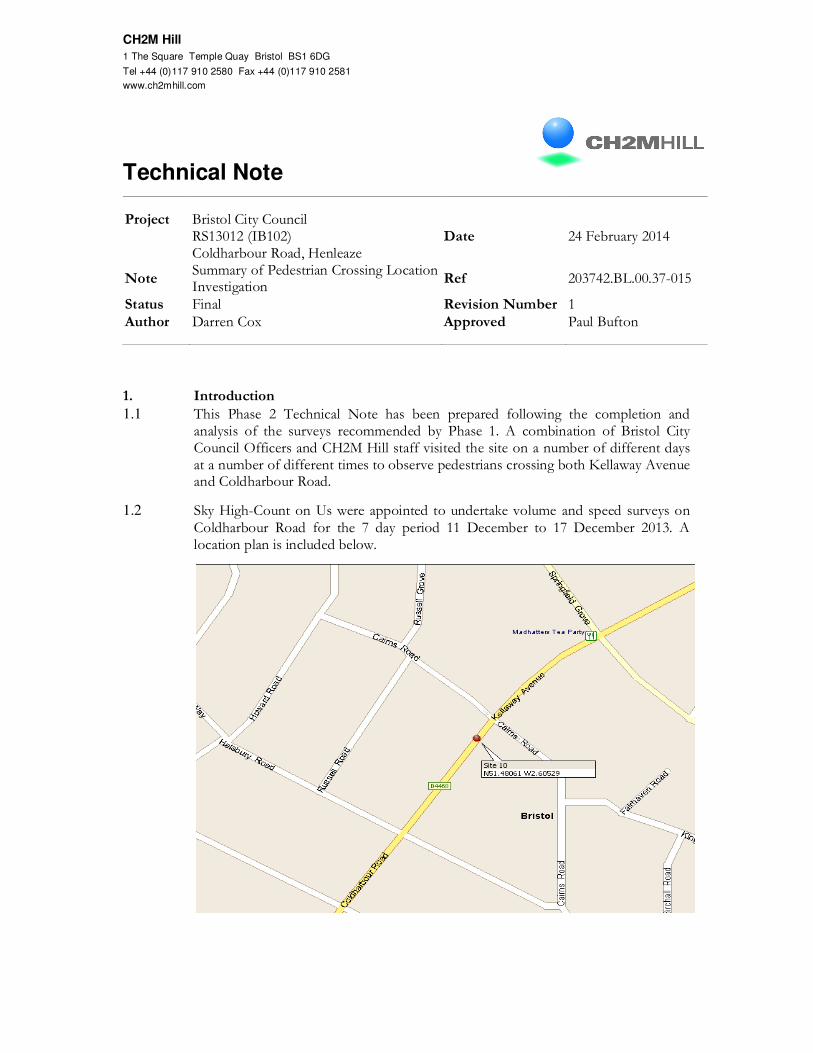
1.1 This Phase 2 Technical Note has been prepared following the completion and analysis of the surveys recommended by Phase 1. A combination of Bristol City Council Officers and CH2M Hill staff visited the site on a number of different days at a number of different times to observe pedestrians crossing both Kellaway Avenue and Coldharbour Road.
1.2 Sky High-Count on Us were appointed to undertake volume and speed surveys on Coldharbour Road for the 7 day period 11 December to 17 December 2013. A location plan is included below.
Technical note Summary of Pedestrian Crossing Location Investigation
Page 2
Project
Bristol City Council RS13012 (IB102) Coldharbour Road, Henleaze
Ref 203742.BL.00.37-015
Registered office: Elms House 43 Brook Green London W6 7EF. Registered in England and Wales. Registered number 3415971
1.3 The results of both surveys are summarised and discussed in more detail in Section 3 of this Technical Note.
1.4 Following the introduction, this Technical Note is structured as follows:
• Section 2 – Background;
• Section 3 – Surveys;
• Section 4 – Recommendation;
• Section 5 – Preliminary Design Option;
• Section 6 – Indicative Costs; and
• Section 7 – Summary.
2. Background
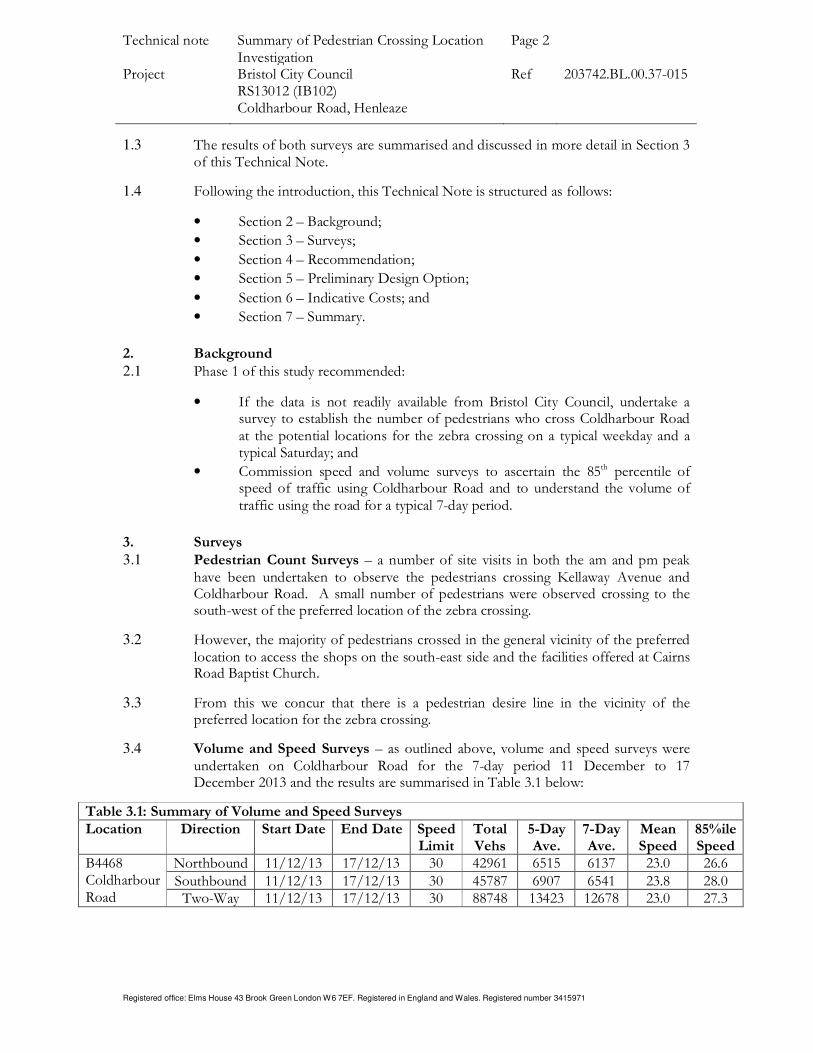
2.1 Phase 1 of this study recommended:
• If the data is not readily available from Bristol City Council, undertake a survey to establish the number of pedestrians who cross Coldharbour Road at the potential locations for the zebra crossing on a typical weekday and a typical Saturday; and
• Commission speed and volume surveys to ascertain the 85th percentile of speed of traffic using Coldharbour Road and to understand the volume of traffic using the road for a typical 7-day period.
3. Surveys
3.1 Pedestrian Count Surveys – a number of site visits in both the am and pm peak have been undertaken to observe the pedestrians crossing Kellaway Avenue and Coldharbour Road. A small number of pedestrians were observed crossing to the south-west of the preferred location of the zebra crossing.
3.2 However, the majority of pedestrians crossed in the general vicinity of the preferred location to access the shops on the south-east side and the facilities offered at Cairns Road Baptist Church.
3.3 From this we concur that there is a pedestrian desire line in the vicinity of the preferred location for the zebra crossing.
3.4 Volume and Speed Surveys – as outlined above, volume and speed surveys were undertaken on Coldharbour Road for the 7-day period 11 December to 17 December 2013 and the results are summarised in Table 3.1 below:
Table 3.1: Summary of Volume and Speed Surveys
Location Direction Start Date End Date Speed Limit
Total Vehs
5-Day Ave.
7-Day Ave.
Mean Speed
85%ile Speed
B4468 Coldharbour Road
Northbound 11/12/13 17/12/13 30 42961 6515 6137 23.0 26.6 Southbound 11/12/13 17/12/13 30 45787 6907 6541 23.8 28.0 Two-Way 11/12/13 17/12/13 30 88748 13423 12678 23.0 27.3
Technical note Summary of Pedestrian Crossing Location Investigation
Page 3
Project
Bristol City Council RS13012 (IB102) Coldharbour Road, Henleaze
Ref 203742.BL.00.37-015
Registered office: Elms House 43 Brook Green London W6 7EF. Registered in England and Wales. Registered number 3415971
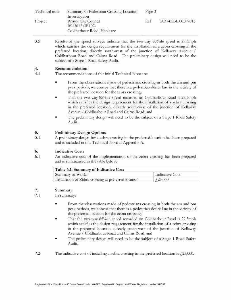
3.5 Results of the speed surveys indicate that the two-way 85%ile speed is 27.3mph which satisfies the design requirement for the installation of a zebra crossing in the preferred location, directly south-west of the junction of Kellaway Avenue / Coldharbour Road and Cairns Road. The preliminary design will need to be the subject of a Stage 1 Road Safety Audit.
4. Recommendation
4.1 The recommendations of this initial Technical Note are:
• From the observations made of pedestrians crossing in both the am and pm peak periods, we concur that there is a pedestrian desire line in the vicinity of the preferred location for the zebra crossing;
• That the two-way 85%ile speed recorded on Coldharbour Road is 27.3mph which satisfies the design requirement for the installation of a zebra crossing in the preferred location, directly south-west of the junction of Kellaway Avenue / Coldharbour Road and Cairns Road; and
• The preliminary design will need to be the subject of a Stage 1 Road Safety Audit.
5. Preliminary Design Options
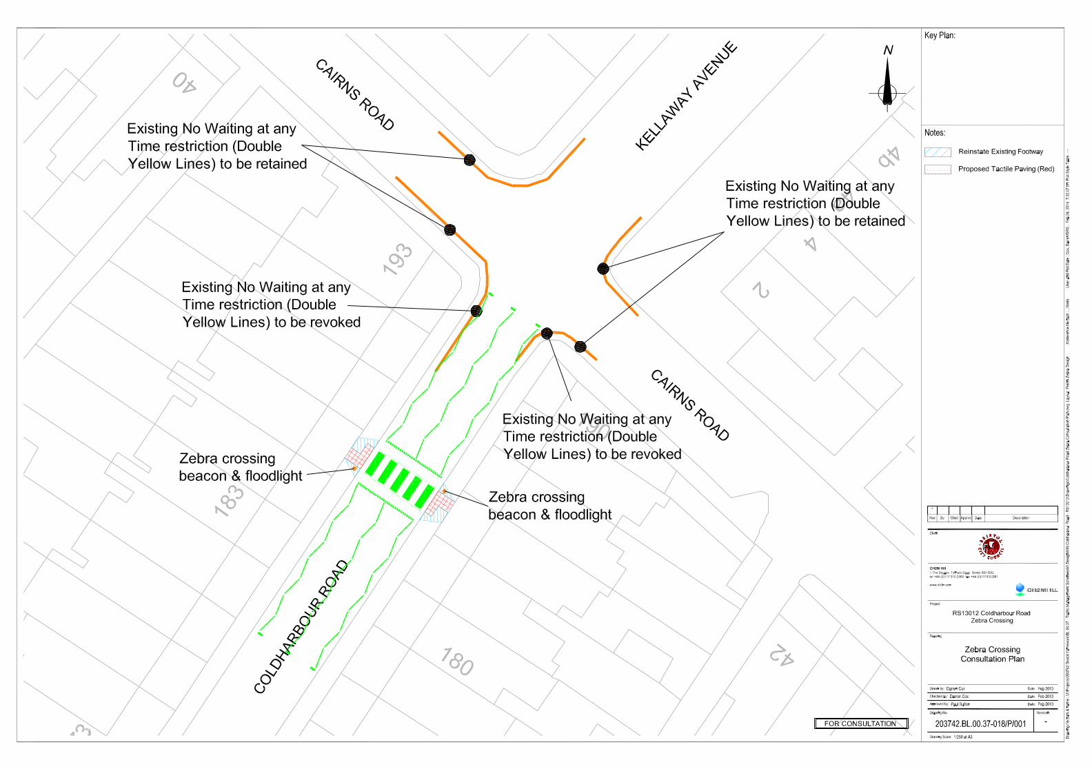
5.1 A preliminary design for a zebra crossing in the preferred location has been prepared and is included in this Technical Note as Appendix A.
6. Indicative Costs
6.1 An indicative cost of the implementation of the zebra crossing has been prepared and is summarised in the table below:
Table 6.1: Summary of Indicative Cost
Summary of Works Indicative Cost Installation of Zebra crossing at preferred location £25,000
7. Summary
7.1 In summary:
• From the observations made of pedestrians crossing in both the am and pm peak periods, we concur that there is a pedestrian desire line in the vicinity of the preferred location for the zebra crossing;
• That the two-way 85%ile speed recorded on Coldharbour Road is 27.3mph which satisfies the design requirement for the installation of a zebra crossing in the preferred location, directly south-west of the junction of Kellaway Avenue / Coldharbour Road and Cairns Road; and
• The preliminary design will need to be the subject of a Stage 1 Road Safety Audit.
7.2 The indicative cost of installing a zebra crossing in the preferred location is £25,000.

Technical note Summary of Parking Restriction Review Page 4
Project
Bristol City Council
RS12061 & RS12062
Parking Restriction Review
Ref 203742.BL.00.37
Registered office: Elms House 43 Brook Green London W6 7EF. Registered in England and Wales. Registered number 3415971
APPENDIX A: Preliminary Design