Embed Size (px)
Citation preview

CENTRAL COAST MARINE PLAN2015
Heiltsuk, Kitasoo/Xai’Xais, Nuxalk, Wuikinuxv Nations &Province of British Columbia

Cite as: Marine Planning Partnership Initiative. 2015. Central Coast Marine Plan. ISBN: 978-0-7726-6886-8Copyright © 2015
Cover Photo Credit: Charles ShortSeaweed Motif: Simon Davies - Jones, Davies & DaviesLayout and Design: Pink Sheep Media
NuxalkNation
WuikinuxvNation
HeiltsukNation
Kitasoo/Xai’Xais Nation
CENTRAL COAST MARINE PLAN2015
Heiltsuk, Kitasoo/Xai’Xais, Nuxalk, Wuikinuxv Nations &Province of British Columbia

CENTRAL COAST MARINE PLANii
iii
CENTRAL COAST MARINE PLANiv
DISCLAIMERThis plan is not legally binding and does not create legally enforceable rights between British Columbia and any of the Heiltsuk, Kitasoo/Xai’Xais, Nuxalk or Wuikinuxv Nations. This plan is not a treaty or land claims agreement within the meaning of sections 25 and 35 of the Canadian Constitution Act, 1982.
This plan does not create, define, evidence, amend, recognize, affirm or deny any Aboriginal rights, Aboriginal title and/or treaty rights or Crown title and rights, and is not evidence of the nature, scope or extent of any Aboriginal rights, Aboriginal title or Crown title and rights.
This plan does not limit or prejudice the positions British Columbia or the Heiltsuk, Kitasoo/Xai’Xais, Nuxalk or Wuikinuxv Nations may take in any negotiations or legal or administrative proceedings.
Nothing in this plan constitutes an admission of fact or liability.
Nothing in this plan alters, defines, fetters or limits or shall be deemed to alter, define, fetter or limit the jurisdiction, authority, obligations or responsibilities of British Columbia or the Heiltsuk, Kitasoo/Xai’Xais, Nuxalk or Wuikinuxv Nations.
PuRPOSE Of DOCuMENTThe purpose of the Central Coast Marine Plan is to identify acceptable marine uses that support sustainable communities while protecting and, where appropriate, restoring marine ecosystems. To this end, the plan includes spatial and aspatial recommendations for marine uses. The Central Coast Marine Plan is the result of a cooperative planning process led by the Heiltsuk, Kitasoo/Xai’Xais, Nuxalk and Wuikinuxv Nations (also referred to collectively within the plan as “the Central Coast Nations”) and the Province of BC on the Central Coast of BC as part of the broader First Nations-BC Marine Planning Partnership for the North Pacific Coast (MaPP) initiative.
The Central Coast Marine Plan recognizes the on-going implementation of the strategic land use agreements between the Heiltsuk (2006), Kitasoo/Xai’Xais (2006), Nuxalk (2008) and Wuikinuxv (2006) Nations and Province of BC. The plan reflects where the Central Coast Nations and the Province hold a shared perspective on how to sustain ecosystem health, social and cultural wellbeing, and economic development through an ecosystem-based approach to planning and management.
The Heiltsuk, Kitasoo/Xai’Xais, Nuxalk and Wuikinuxv Nations and the Province of British Columbia recognize that implementation of some of the objectives and strategies as well as the spatial Protection Management Zones (PMZ) in this document will require the support of others through various processes. Many of the strategies reference working with other agencies and linking with other relevant processes to ensure the goals and objectives of the Central Coast Marine Plan are achieved.

v
CENTRAL COAST VISION STATEMENT Connections between the land, the sea and the people are valued. Healthy marine ecosystems support human wellbeing, sustainable community prosperity and cultural resilience for future generations. The governance and management promoted by the Central Coast Marine Plan is collaborative, effective, transparent and integrated across jurisdictions, First Nations territories and international boundaries. Management incorporates evolving information and adapts to changing social, technological and environmental conditions.
Photo by Ian McAllister

CENTRAL COAST MARINE PLANvi
ACkNOwLEDgEMENTSThe Central Coast Marine Plan represents the culmination of several years of dedicated work by dozens of people who represent the Heiltsuk, Kitasoo/Xai’Xais, Nuxalk and Wuikinuxv Nations, the Province of BC, and various marine sector interests.
The Heiltsuk, Kitasoo/Xai’Xais, Nuxalk and Wuikinuxv Nations and the Province of BC would like to recognize and thank the following individuals who played key roles in providing technical support, direction and oversight on the production of this document:
Central Coast First Nations: Julie Carpenter, Mike Reid, Kelly Brown, Earl Newman Jr., Doug Neasloss, Vernon Brown, Whitney Sadowski, Larry Greba, Wilfred Dawson, Wally Webber, Blair Mack, Marshall Hans Jr., Spencer Siwallace, Danielle Shaw, Peter Johnson, Andrew Johnson, Susan Anderson Behn, Frank Hanuse and the members of the Heiltsuk Marine Use Planning Committee, Kitasoo/Xai’Xais Stewardship Board, Nuxalk Marine Use Planning Board, and the Wuikinuxv Stewardship Committee.
Central Coast Marine Plan Advisory Committee (MPAC): Karin Bodtker, Diana Chan, Mairi Edgar, Greta Geankoplis, Hans Granander, Nick Heath, Paul Kariya, Sid Keay, Janice Kyle, Brian Lande, Evan Loveless, Jim McIsaac, Les Neasloss, Kim Olsen, Richard Opala, Mike Pfortmueller, Anne Salomon, Alison Sayers, Jamie Scarrow, Roberta Stevenson, Warren Warttig, and Gary Wilson.
Marine Working Group: Robert Grodecki, Allan Lidstone, Doug Neasloss, Merv Child, Garry Wouters, and Trevor Russ.
Marine Coordination Team: John Bones, Steve Diggon, Matthew Justice, and Charles Short.
Central Coast Technical Team: Sally Cargill and Brad Smith (FLNRO), Ken Cripps, Gord McGee, and Aaron Heidt (Central Coast Indigenous Resource Alliance).
MaPP Support Staff: Josie Byington, Fiona Kilburn, Jo Smith, Kelly Wozniak, Craig Darling (MPAC Facilitator), and Gary Runka (MPAC Facilitator).
The Heiltsuk, Kitasoo/Xai’Xais, Nuxalk and Wuikinuxv Nations and the Province of BC also acknowledge the valuable input provided by members of the general public, who submitted comments through public open houses and the MaPP website. In addition, many people provided input on the draft plan during the Provincial and First Nations internal review processes.
The Heiltsuk, Kitasoo/Xai’Xais, Nuxalk and Wuikinuxv Nations and the Province of BC wish to acknowledge the financial support of the Gordon and Betty Moore Foundation through the MaPP Support Project at Tides Canada.
vii
ExECuTIVE SuMMARyThe Central Coast Marine Plan is the result of a cooperative planning process led by the Province of British Columbia (BC) and the Heiltsuk, Kitasoo/Xai’Xais, Nuxalk and Wuikinuxv Nations. This planning process is part of the broader First Nations-BC Marine Planning Partnership for the North Pacific Coast (MaPP) initiative. The plan focuses on the marine areas and uses in the foreshore (intertidal zone), coastal “inland waters”, and the lands covered by these waters. It considers the uses, plans, zones, tenures and legal designations that are in place on the land adjacent to marine areas and the seabed, but does not propose specific management objectives for private lands or uplands. The plan does not provide, imply direction or make recommendations of matters that the Province believes are solely within federal jurisdiction.
The overarching purpose of the Central Coast Marine Plan is to identify acceptable marine uses that support sustainable communities while protecting and, where appropriate, restoring marine ecosystems. The Central Coast Marine Plan:
i. Provides a framework for joint or shared management of marine and coastal areas in the Central Coast through an ecosystem-based management (EBM) approach to marine resource decision-making;
ii. Provides policy, detailed planning, and management direction regarding marine uses, activities and values throughout the Plan Area;
iii. Supports marine economic development and provides direction for encouraging and managing future growth;
iv. Provides guidance for tenuring and marine resource use decisions in the Central Coast Plan Area; and
v. Provides valuable information that will make important contributions to future processes between the Heiltsuk, Kitasoo/Xai’Xais, Nuxalk and/or Wuikinuxv Nations, BC and/or Canada, such as identifying areas for consideration in the development of a marine protected area network.
Plan Overview Chapter 1 explains what the MaPP initiative is and outlines the scope of the plan. The Central Coast Marine Plan uses a marine EBM approach, which is consistent with First Nations’ resource management approaches and with provincial government direction in resource management. EBM is built on principles of ecological integrity, human well-being, and governance and collaborative management. It recognizes the impacts of interactions in an ecosystem and places human activities and impacts into the ecosystem management framework. Management direction for EBM is incorporated into all of the objectives and strategies in the Plan.
Chapter 2 explains the process followed during development of the Central Coast Marine Plan, including a description of joint management structures that governed the MaPP initiative, information used to develop the plan, and related planning initiatives. The plan has been jointly developed by the Heiltsuk, Kitasoo/Xai’Xais, Nuxalk and Wuikinuxv Nations and the Province of BC with input from the Central Coast Marine Plan Advisory Committee (MPAC), central coast communities, stakeholders, local governments and the broader public. The plan brings together science, Traditional Knowledge, local knowledge, and input from Kitasoo/Xai’Xais, Heiltsuk, Nuxalk and Wuikinuxv technical staff and the Province of BC. Key information and direction was provided by First Nations strategic marine use plans and existing provincial mandate, planning and policy documents.

CENTRAL COAST MARINE PLANviii
Chapter 3 describes the ecological, cultural and socio-economic features in the Plan Area. For the purposes of MaPP, the Central Coast extends from Laredo Channel and the northern tip of Aristazabal Island in the north to the southern limit of Rivers Inlet and Calvert Island. Hundreds of islands, exposed rocky headlands, nearshore kelp forests and the shelf waters of Queen Charlotte Sound characterise the Central Coast’s marine and coastal areas. Within the Plan Area, the exposed outer coast meets an intricate shoreline that is cut by narrow channels and steep-walled fjords and contains ecologically complex estuaries, calm inlets and pocket coves. The diversity of habitats provides for some of the richest and most complex ecosystems in the world, which in turn has supported ancient civilizations and allowed rich and complex cultures and societies to develop. Over the last century, Central Coast economies relied primarily on commercial logging and fishing industries. While these industries are still critical to the local economies, it is also becoming more diversified with a recent focus on aquaculture, tourism and other service sectors.
Chapter 4 summarizes some of the key threats, challenges and opportunities that precipitated the development of the Central Coast Marine Plan. In particular, the multitude of pressures on ocean health, a lack of economic diversity in the region, impacts of climate change and ocean acidification, inadequate protection of cultural and archaeological resources, health of fish and marine resources, and the lack of local benefits from the marine fisheries economy were key issues identified in the planning process. Collaborative marine planning provides an opportunity to respond to these issues in a more holistic and integrated manner.
Chapter 5 sets out objectives and strategies for achieving healthier oceans, stronger marine economies and improved cultural and social outcomes in the Plan Area. Management direction is provided for the following key areas:
5.1 Governance: includes recommendations for strengthening marine-based governance relationships, including recommendations for developing the governance structures required to implement the Central Coast Marine Plan.
5.2 Monitoring and Enforcement: intended to improve coordination and collaboration among appropriate Crown agencies and the Heiltsuk, Kitasoo/Xai’Xais, Nuxalk and Wuikinuxv Nations, and research and user groups that conduct monitoring activities.
5.3 Economy and Communities: aims to increase First Nations and local community participation in the marine economy while taking into consideration ecosystem health and human wellbeing.
5.4 Protection: focuses on implementing all of the objectives, strategies and spatial zones in the Central Coast Marine Plan that contribute to protection of prioritized ecosystems, species and ecological processes in the Plan Area.
5.5 Climate Change Adaptation and Mitigation: provides objectives and strategies intended to prepare for and mitigate a range of changes while incorporating provisions for unknowns.
5.6 Cumulative Effects Assessment: includes recommendations for identifying potential management indicators and objectives, as well as associated targets and thresholds, necessary to inform application of the MaPP Cumulative Effects Assessment Framework in the Central Coast Plan Area.

ix
5.7 Pollution: includes pollution prevention, mitigation and remediation measures with a focus on the creation of marine response plans to address the limited capacity in the Plan Area to respond to large-scale events such as oil spills and marine emergencies.
5.8 Tenured Activies: includes general direction for all tenures and specific direction for renewable energy, aquaculture, and forestry operations with a focus on ecological and cultural protection, reduced conflict between users, and economic development that benefits Central Coast communities.
5.9 Traditional , Cultural and Heritage Resources: focuses on protecting cultural sites and cultural areas to promote and sustain Traditional and cultural resources and provide opportunities for Traditional use by current and future generations.
5.10 Tourism and Recreation: intends to increase economic opportunities for local communities, reduce conflict between users, and ensure negative impacts on marine wildlife and habitats are minimized.
5.11 Marine Fisheries Economy: intends to reduce conflict between participants in the fisheries economy and other marine uses and activities, minimize ecological and cultural impacts from sport fishing lodges, increase enhancement and restoration activities, and increase local economic benefits from fisheries and other seafood processing activities.
Chapter 6 describes the approach to managing marine uses and activities through the establishment of spatially defined areas, or zones. There are three types of zones in the Central Coast Marine Plan, each with associated recommendations on uses and activities, all of which fall within the EBM framework:1
The General Management Zone (GMZ) (78.65 percent of Plan Area) supports a wide range of public, private and community marine uses and activities.
The Special Management Zone (SMZ) (3.43 percent of Plan Area) allocates space for high priority and/or high potential marine uses and activities that require specific environmental conditions or locations. The SMZ includes three categories:
» Aquaculture SMZs (0.95 percent of Plan Area) place an emphasis on development of the aquaculture industry, as appropriate.
» Recreation and Tourism SMZs (0.31 percent of Plan Area) place an emphasis on recreation and tourism activities and uses.
» Renewable Energy SMZs (2.17 percent of Plan Area) place an emphasis on growth and development of the renewable energy industry.
The Protection Management Zone (PMZ) (17.53 percent of Plan Area) allocates space primarily for conservation purposes or objectives. PMZs were identified using, and align with, International Union for Conservation of Nature (IUCN) guidelines. The PMZs are not designating Marine Protected Areas and do not provide recommendations on marine uses and activities outside of provincial regulatory authority.2
1 Five areas that cover a total of 0.23% of the Plan Area have not been assigned a zone type. A variety of ecological, economic, cultural and social values will be considered through more detailed planning for these zones (see Strategy 3.3 in Section 5.8 of the Plan).
2 Two zones from the North Coast Marine Plan extend into the Central Coast Plan Area and allocate an additional 0.17 percent of the Plan Area as Protection Management Zones.

CENTRAL COAST MARINE PLANx
The PMZ includes three categories:
Zone Type Category % Central Coast Plan Area
MaPP Description
PMZ High Protection
IUCN Ib 0.02 Areas of highest conservation value with an emphasis on protecting marine species, ecosystems and ecological processes in their natural state. These areas have significant ecological values, including rare or threatened species or ecosystems. They may also represent marine ecosystem types. Limited activities can occur in these areas provided they do not impact the conservation objectives of each zone. Compatible activities may include: scientific research and some types of public and commercial recreation and tourism.
IUCN II 7.71
PMZ Medium Protection
IUCN IV 9.81 Areas primarily identified to protect particular species or habitats. A range of activities can occur provided they do not impact the conservation objectives for each zone. Compatible activities may include: scientific research, some types of public and commercial recreation and tourism, anchorage, small scale infrastructure (e.g. docks, boat ramps).
Note: Zoning does not direct uses or activities outside of provincial regulatory authority.
Recommended Uses and Activities Tables were created for each zone in the Central Coast Marine Plan. The tables identify the acceptable, conditionally acceptable, or not acceptable uses and activities for a particular zone. For every activity that is considered conditionally acceptable, conditional statements are included that provide additional direction on those particular uses and activities.
Chapter 7 describes how the Central Coast Marine Plan will be implemented, monitored, reviewed and adapted over time. Objectives and strategies in this Marine Plan will be implemented on a priority basis. Priorities for near-term implementation over the next five years are identified. The goal is to implement all strategies in the Central Coast Marine Plan over the longer term, as funding and other resources permit.
The Central Coast Marine Plan is a living document that will be updated over time to remain relevant as issues, priorities and conditions change. Plan evaluation and review will be ongoing throughout implementation and is considered a crucial element to successfully achieving plan outcomes. A variance process will also be established that may include consideration of new technologies/methods of operation, new activities or ventures, and/or new information that was not available when the plan was developed.

xi
ACRONyMS BC British Columbia
CEA Cumulative Effects Assessment
CEAF Cumulative Effects Assessment Framework
DFO Department of Fisheries and Oceans Canada
EBM Ecosystem-Based Management
EEZ Exclusive Economic Zone
FLNRO Ministry of Forests, Lands and Natural Resource Operations
GMZ General Management Zone
IUCN International Union for Conservation of Nature
LRMP Land and Resource Management Plan
MaPP Marine Planning Partnership (for the Pacific North Coast)
MCT Marine Coordination Team
MPA Marine Protected Area
MPAC Marine Plan Advisory Committee
MWG Marine Working Group
PMZ Protection Management Zone
PNCIMA Pacific North Coast Integrated Management Area
RCMP Royal Canadian Mounted Police
RMAC Regional Marine Advisory Committee
SAC Science Advisory Committee
SMZ Special Management Zone
TOR Terms of Reference

CENTRAL COAST MARINE PLANxii
TAbLE Of CONTENTSDisclaimer ivPurpose of document ivCentral Coast Vision Statement vAcknowledgements viExecutive Summary vii
Plan Overview vii
Acronyms xiChapter 1: Introduction 1
1.1 Scope and Jurisdiction 4
Chapter 2: Planning Approach 52.1 Process Overview 6
2.2 Related Planning Initiatives 10
2.3 Ecosystem-Based Management 12
Chapter 3: The Plan Area 143.1 Description 17
Chapter 4: Key Issues, Concerns and Opportunities 194.1 Ocean Health 20
4.2 Economic Development 20
4.3 Climate Change and Ocean Acidification 21
4.4 Cultural and Archaeological Resources 21
4.5 Health of Fish and other Marine Resources 21
4.6 Marine Fisheries Economy 21
Chapter 5: Management Direction 225.1 Governance 22
5.2 Monitoring and Enforcement 24
5.3 Economy and Communities 26
5.4 Protection 28
5.5 Climate Change Adaptation and Mitigation 31
5.6 Cumulative Effects Assessment 36
5.7 Pollution 37
5.8 Tenured Activities 40
5.9 Traditional, Cultural and Heritage Resources 45
5.10 Tourism and Recreation 48
5.11 Marine Fisheries Economy 49

xiii
Chapter 6: Marine Spatial Plan 546.1 Zoning Descriptions 56
6.2 Boundary Delineation 58
6.3 Recommended Uses and Activities within Zones 59
6.4 Central Coast Marine Plan Zoning Summary 61
6.5 Spatial Zoning 61Spatial Planning Group 1 (Laredo) 63
Spatial Planning Group 2 (Finlayson) 68
Spatial Planning Group 3 (Tolmie) 73
Spatial Planning Group 4 (Milbanke) 78
Spatial Planning Group 5 (Seaforth/Spiller) 83
Spatial Planning Group 6 (Gunboat/Lama) 88
Spatial Planning Group 7 (Hunter Isand Group) 94
Spatial Planning Group 8 (Calvert) 100
Spatial Planning Group 9 (Penrose) 106
Spatial Planning Group 10 (Rivers Inlet) 111
Spatial Planning Group 11 (Burke/Fisher) 116
Spatial Planning Group 12 (Dean/Bentinck) 122
Chapter 7: Central Coast Marine Plan Implementation and Monitoring 1297.1 Implementation Agreement 129
7.2 Plan Priorities 130
7.3 Implementation Funding 134
7.4 Technical Team 134
7.5 Plan Implementation and Monitoring Committee 135
7.6 Indicators and Monitoring 136
7.7 Plan Evaluation, Review and Amendment 137
7.8 Central Coast Marine Plan Compliance 138
7.9 Central Coast Marine Plan Variance 138
Glossary 139References 144Appendices 148Appendix A: MPAC Membership 149Appendix B: MaPP Definitions of Marine Uses and Activities 151Appendix C: Descriptions of IUCN Categories 154Appendix D: Potential EBM Indicators 155Appendix E: Implementation Tools Relevant to the Central Coast Marine Plan 163

CENTRAL COAST MARINE PLANxiv
LIST Of TAbLESTable 1. Governance: Management issues, objectives and strategies 23
Table 2. Compliance monitoring and enforcement: Management issues, objectives and strategies 25
Table 3. Effectiveness monitoring and EBM monitoring 26
Table 4. Economy and communities: Management issues, objectives and strategies 27
Table 5. Protection: Management issues, objectives and strategies 31
Table 6. Climate change adaptation and mitigation: Management issues, objectives and strategies 33
Table 7. Cumulative effects assessment: Management issues, objectives and strategies 37
Table 8. Pollution: Management issues, objectives and strategies 38
Table 9. Tenured activities: Management issues, objectives and strategies 40
Table 10. Renewable energy: Management issues, objectives and strategies 42
Table 11. Aquaculture: Management issues, objectives and strategies 43
Table 12. Forestry Operations: Management issues, objectives and strategies 45
Table 13. Traditional, cultural and heritage resources: Management issues, objectives and strategies 46
Table 14. Tourism and recreation: Management issues, objectives and strategies 49
Table 15. Marine fisheries economy: Management issues, objectives and strategies 51
Table 16. MaPP Zoning Framework: Zone type, description and objective 56
Table 17. Categories used in the Recommended Uses and Activities Tables 60
Table 18. Summary table of zones by category type, length of shoreline and area 61
Table 19. Group 1 (Laredo) zone objectives and area descriptions 64
Table 20. Group 1 (Laredo) Recommended Uses and Activities Table 66
Table 21. Group 1 (Laredo) conditional statements 67
Table 22. Group 2 (Finlayson) zone objectives and area descriptions 69
Table 23. Group 2 (Finlayson) Recommended Uses and Activities Table 71
Table 24. Group 2 (Finlayson) conditional statements 72
Table 25. Group 3 (Tolmie) zone objectives and area descriptions 74
Table 26. Group 3 (Tolmie) Recommended Uses and Activities Table 76
Table 27. Group 3 (Tolmie) conditional statements 77
Table 28. Group 4 (Milbanke) zone objectives and area descriptions 79
Table 29. Group 4 (Milbanke) Recommended Uses and Activities Table 81
Table 30. Group 4 (Milbanke) conditional statements 82

xv
Table 31. Group 5 (Seaforth/Spiller) zone objectives and area descriptions 84
Table 32: Group 5 (Seaforth/Spiller) Recommended Uses and Activities Table 86
Table 33. Group 5 (Seaforth/Spiller) conditional statements 87
Table 34. Group 6 (Gunboat/Lama) zone objectives and area descriptions 89
Table 35. Group 6 (Gunboat/Lama) Recommended Uses and Activities Table 92
Table 36. Group 6 (Gunboat/Lama) conditional statements 93
Table 37. Group 7 (Hunter Island Group) zone objectives and area descriptions 95
Table 38. Group 7 (Hunter Island Group) Recommended Uses and Activities Table 98
Table 39. Group 7 (Hunter Island Group) conditional statements 99
Table 40. Group 8 (Calvert) zone objectives and area descriptions 101
Table 41. Group 8 (Calvert) Recommended Uses and Activities Table 104
Table 42. Group 8 (Calvert) conditional statements 105
Table 43. Group 9 (Penrose) zone objectives and area descriptions 107
Table 44. Group 9 (Penrose) Recommended Uses and Activities Table 109
Table 45. Group 9 (Penrose) conditional statements 110
Table 46. Group 10 (Rivers Inlet) zone objectives and area descriptions 112
Table 47. Group 10 (Rivers Inlet) Recommended Uses and Activities Table 114
Table 48. Group 10 (Rivers Inlet) conditional statements 115
Table 49. Group 11 (Burke/Fisher) zone objectives and area descriptions 117
Table 50. Group 11 (Burke/Fisher) Recommended Uses and Activities Table 120
Table 51. Group 11 (Burke/Fisher) conditional statements 121
Table 52. Group 12 (Dean/Bentinck) zone objectives and area descriptions 123
Table 53. Group 12 (Dean/Bentinck) Recommended Uses and Activities Table 127
Table 54. Group 12 (Dean/Bentinck) conditional statements 128
Table 55. Key outcomes and priority actions for implementation of the Central Coast Marine Plan 130
Table 56. MPAC membership 149
Table 57. MPAC meeting dates and topics 149
Table 58. MaPP Definitions of Marine Uses and Activities 151
Table 59. Descriptions of IUCN categories 154
Table 60. Potential EBM Indicators 155
Table 61. Implementation Tools Relevant to the Central Coast Marine Plan 163

CENTRAL COAST MARINE PLANxvi
TAbLE Of fIguRESFigure 1. Marine Planning Partnership for the North Pacific Coast (MaPP) sub-regional planning boundaries 17
Figure 2. Key phases during development of the Central Coast Marine Plan 20
Figure 3: Interaction of MaPP management, planning and advisory bodies 21
Figure 4. Overview of Central Coast Plan Area 29
Figure 5. Central Coast Plan Area communities 30
Figure 6. Proposed and existing marine protection in the Central Coast Plan Area 43
Figure 7. Key steps followed during spatial planning 69
Figure 8. Central Coast spatial planning groups 76
Figure 9. Spatial Planning Group 1 (Laredo) 77
Figure 10. Spatial Planning Group 2 (Finlayson) 82
Figure 11. Spatial Planning Group 3 (Tolmie) 87
Figure 12. Spatial Planning Group 4 (Milbanke) 92
Figure 13. Spatial Planning Group 5 (Seaforth/Spiller) 97
Figure 14. Spatial Planning Group 6 (Gunboat/Lama) 102
Figure 15. Spatial Planning Group 7 (Hunter Island Group) 108
Figure 16. Spatial Planning Group 8 (Calvert) 114
Figure 17. Spatial Planning Group 9 (Penrose) 120
Figure 18. Spatial Planning Group 10 (Rivers Inlet) 125
Figure 19. Spatial Planning Group 11 (Burke/Fisher) 130
Figure 20. Spatial Planning Group 12 (Dean/Bentinck) 136

1ChAPTER 1
ChAPTER 1: INTRODuCTION
The Marine Planning Partnership for the North Pacific Coast (MaPP) is a collaborative planning process for coastal and marine areas in four sub-regions of British Columbia (BC). MaPP is a partnership between the Province of British Columbia, the Coastal First Nations-Great Bear Initiative, the North Coast–Skeena First Nations Stewardship Society and the Nanwakolas Council. The partnership includes 18 member First Nations. The Heiltsuk, Kitasoo/Xai’Xais, Nuxalk and Wuikinuxv Nations are members of the Coastal First Nations-Great Bear Initiative.
Photo by Ian McAllister

CENTRAL COAST MARINE PLAN2
MaPP was established to develop:
» sub-regional marine plans for Haida Gwaii, the North Coast, the Central Coast and Northern Vancouver Island (Figure 1) that are comprised of aspatial management direction and spatial zones;
» a Regional Action Framework that aggregates sub-regional components that are regional in scope and includes frameworks for topics of regional importance that are captured in the sub-regional marine plans; and
» Marine Plan Implementation Agreements that provide specific guidance for day-to-day operations and marine use decisions addressed within the sub-regional marine plans and the Regional Action Framework.
Ecosystem-based management (EBM) provided the foundation for the development of these outputs. EBM is an adaptive approach to managing human activities that seeks to ensure the coexistence of healthy, fully functioning ecosystems and human communities. The intent of EBM is to maintain the spatial and temporal characteristics of ecosystems such that component species and ecological processes can be sustained and human wellbeing can be supported and improved (see Section 2.3 for more detail on EBM). The principles of EBM are very similar to the principles and ethics which inform resource management and enhancement by Central Coast Nations now and for thousands of years.
Together, the outputs created through the MaPP initiative seek to sustain healthy marine ecosystems, cultures, societies and economies for First Nations and BC coastal communities. In order to develop these outputs, MaPP brought together the best available science, Traditional Knowledge, and other information from stakeholder and public engagement processes.
This document is the Central Coast Marine Plan and has been jointly developed by Heiltsuk, Kitasoo/Xai’Xais, Nuxalk and Wuikinuxv Nations and the Province of BC. Other key MaPP outputs, including the Haida Gwaii Marine Plan, North Coast Marine Plan, North Vancouver Island Marine Plan, the Regional Action Framework, and reports and supporting documents used in the development of the Central Coast Marine Plan are available on the MaPP website (http://mappocean.org/).

3ChAPTER 1
figure 1. Marine Planning Partnership for the North Pacific Coast (MaPP) sub-regional planning boundaries
CENTRAL COAST MARINE PLAN4
1.1 Scope and Jurisdiction As between Canada and the Province, the Constitution Act (1867) defines the federal-provincial distribution of legislative powers in Canada (also known as the division of powers), including the scope of the power of the federal parliament of Canada and the powers of each individual provincial legislature or assembly. Without formal federal government involvement in the MaPP planning process, this division of power limits the Province from endorsing outcomes that it considers to be the exclusive jurisdiction and mandate of the federal government under the Constitution Act. However, the Province is able to support and implement components of the Central Coast Marine Plan where, as between BC and Canada, the Province has some jurisdiction.
In 1984 in the Strait of Georgia Reference, a dispute between Canada and B.C., the Supreme Court of Canada was asked whether “all the lands, including the minerals and other natural resources of the seabed and subsoil covered by the waters of the Strait of Juan de Fuca, the Strait of Georgia (sometimes called the Gulf of Georgia), Johnstone Strait and Queen Charlotte Strait…” were the property of the Province of British Columbia. The Court answered in favour of the Province of British Columbia by finding that when British Columbia entered Confederation in 1871, the Province consisted of all British territories, including dry land, coastal straits and submerged lands. Thus as between British Columbia and Canada, British Columbia owns the waters and submerged lands of the Strait of Juan de Fuca, the Strait of Georgia, Johnstone Strait and Queen Charlotte Strait and the waters and submerged lands between major headlands (i.e., bays, estuaries, and fjords).
The Central Coast Marine Plan covers a major portion of the territories of the Heiltsuk, Kitasoo/Xai’Xais, Nuxalk and Wuikinuxv Nations. These First Nations assert aboriginal title and rights, including ownership, jurisdiction and management over the lands, waters and resources, including the marine spaces, throughout their respective territories. Their respective laws and traditions hold them responsible for ensuring that among other things, healthy sustainable territories, including the natural and cultural heritage of Heiltsuk, Kitasoo/Xai’Xais, Nuxalk and Wuikinuxv territories, are passed on to future generations. Similar to land use plans, the Central Coast Marine Plan seeks to develop a framework for joint or shared management of marine and coastal areas on the Central Coast.
The Central Coast Marine Plan does not provide, imply direction or make recommendations on matters that the Province believes are solely within federal jurisdiction.

5ChAPTER 2: PLANNINg APPROACh
ChAPTER 2: PLANNINg APPROACh
The Central Coast Marine Plan includes spatial zones with associated management direction, and aspatial management direction for the following marine activities, uses and values:
» governance
» monitoring and enforcement
» economy and communities
» protection
» climate change
» cumulative effects assessment
» pollution
» tenured activities (including specific focus on renewable energy, aquaculture and forestry operations)
» traditional and cultural resources
» tourism and recreation
» marine fisheries economy
Photo by Ian McAllister

6 CENTRAL COAST MARINE PLAN
2.1 Process OverviewThe MaPP process for the Central Coast is co-lead by the Heiltsuk, Kitasoo/Xai’Xais, Nuxalk and Wuikinuxv Nations and the Province of BC. The Central Coast Marine Plan has been jointly developed by these parties with input from the Central Coast Marine Planning Advisory Committee (MPAC), central coast communities, stakeholders and the broader public. Development of the Central Coast Marine Plan unfolded through five key phases (Figure 2).
Phase 1: Process Initiation
Phase 2: Information Gathering
Phase 3: Plan Development
Phase 4: Plan Review
Phase 5: Plan Approval
figure 2. key phases during development of the Central Coast Marine Plan
Phase 1: Process Initiation
MaPP was formally initiated in November 2011 when a Letter of Intent was signed by the Province of British Columbia, represented by the Minister of Forests, Lands and Natural Resource Operations, and 18 First Nations, represented by the Coastal First Nations-Great Bear Initiative, the North Coast–Skeena First Nations Stewardship Society and the Nanwakolas Council. The Heiltsuk, Kitasoo/Xai’Xais, Nuxalk and Wuikinuxv Nations are members of the Coastal First Nations-Great Bear Initiative.
The following joint management structures that governed the MaPP initiative were established in a Letter of Intent:
» Executive Committee: an executive-level committee comprised of ministers or deputy/assistant deputy ministers from the Province of British Columbia and chiefs or executive-level representatives of the Coastal First Nations-Great Bear Initiative, North Coast Skeena First Nations Stewardship Society and the Nanwakolas Council. The Executive Committee helped resolve high-level issues as they arose.
» Marine Working Group: a high-level regional advisory body comprised of sub-regional representatives from the Province of British Columbia, Heiltsuk, Kitasoo/Xai’Xais, Nuxalk and Wuikinuxv Nations, the Council of the Haida Nation, the North Coast–Skeena First Nations Stewardship Society and the Nanwakolas Council. The Marine Working Group provided strategic direction and executive oversight to MaPP regional and sub-regional planning work.
» Marine Coordination Team: a regional coordinating body comprised of senior technical staff from the Province of British Columbia, Coastal First Nations and the Nanwakolas Council. The Marine Coordination Team promoted consistency in the work of the four Sub-regional Technical Teams and managed the integration of the sub-regional marine plans.

7ChAPTER 2: PLANNINg APPROACh
» Sub-regional Technical Teams: four technical teams co-led by sub-regional representatives from First Nations and the Province of British Columbia. The Sub-regional Technical Teams developed the sub-regional marine plans and provided input into the Regional Planning Framework. In the Central Coast sub-region, the planning process was co-led by technical staff representing the Heiltsuk, Kitasoo/Xai’Xais, Nuxalk and Wuikinuxv Nations and the Province of British Columbia.
Figure 3 illustrates how the Marine Working Group, Marine Coordination Team, Sub-regional Technical Teams and the various advisory committees interacted in the development of the Central Coast Marine Plan.
Regional Planning Team
Haida Gwaii
North Coast
Central Coast
North Vancouver Island
Sub-Regional Technical Teams
Regional Marine Advisory Committee
Marine Advisory Committee
Marine Plan Advisory Committee
Marine Plan Advisory Committee
Marine Plan Advisory Committee
Sub-Regional Advisory Committees
Science Advisory Committee
Advisory to Process
Marine Coordination Team
Plan
ning
and
Pro
cess
Man
agem
ent
Exec
utiv
e M
anag
emen
t
Marine Working Group
Executive Committee
Administrative, Science and Communications Support
figure 3: Interaction of MaPP management, planning and advisory bodies

8 CENTRAL COAST MARINE PLAN
Phase 2: Information Gathering
The Central Coast Marine Plan was jointly developed by the Heiltsuk, Kitasoo/Xai’Xais, Nuxalk and Wuikinuxv Nations and the Province of BC using information from a variety of sources, including First Nations’ Traditional Knowledge and marine management data, Crown government reports and publications, academic literature, industry and sector feedback and publications, and discussions with experts. Information consisted of:
» traditional and local knowledge;
» ecological data;
» marine use or activity data (e.g., fisheries, tourism, tenures, aquaculture, energy); and
» socioeconomic data and information.
A Science Advisory Committee was established to provide scientific and technical knowledge and feedback, as requested, on MaPP products and reports. Members of the Science Advisory Committee had expertise in biological sciences, marine planning, socioeconomics, ecosystems and ecosystem services, Traditional Knowledge, oceanography and marine ecological modelling. A pool of science and technical experts was also established to provide advice and review products related to their expertise on an as-needed basis.
A Science Coordinator ensured the quality of products and worked with the Marine Coordination Team to guide the development of regional and overarching products and tools used by the Sub-regional Technical Teams.
Development of the Central Coast Marine Plan was guided by principles of openness and collaboration. All information used to develop this plan is available upon request, except for information that is legally recognized as confidential under the Freedom of Information and Protection of Privacy Act (FOIPPA). Third-party information used during the planning process may be released only in accordance with FOIPPA.
Phase 3: Draft Plan Development
A draft Central Coast Marine Plan was jointly developed by technical staff representing the Heiltsuk, Kitasoo/Xai’Xais, Nuxalk and Wuikinuxv Nations and the Province of BC. Central Coast Nations’ technical staff relied on oversight and direction from the Heiltsuk, Kitasoo/Xai’Xais, Nuxalk and Wuikinuxv marine planning committees; Nation-level information sources, including Traditional Knowledge studies, Central Coast Nations social and economic assessments, and a traditional resources needs study; and, the policies and management direction provided in the Heiltsuk Marine Use Plan, Kitasoo/Xai’Xais Marine Use Plan, Nuxalk Marine Plan, and Wuikinuxv Marine Use Plan.
Provincial technical staff relied on direction contained within provincial policies and plans as well as provincial priorities during the drafting of the Central Coast Marine Plan. The draft plan underwent rigorous internal provincial agency review and comments and advice were incorporated where appropriate.
Stakeholder Engagement
The Central Coast Marine Plan Advisory Committee (MPAC) was established to provide advice and feedback to the Heiltsuk, Kitasoo/Xai’Xais, Nuxalk and Wuikinuxv Nations and the Province of British Columbia on the development of the draft Central Coast Marine Plan. The MPAC was comprised of members from a range of backgrounds, including those with local and nonlocal expertise in coastal forestry, commercial tourism, marine

9ChAPTER 2: PLANNINg APPROACh
conservation, finfish aquaculture, shellfish aquaculture, local government, public recreation, recreational fishing services, renewable energy, commercial fisheries and marine-related academia. A complete list of participating sectors and their representatives is included in Appendix A: MPAC Membership. MPAC members were responsible for:
» communicating on a regular basis with individuals and organisations that had similar marine interests in order to convey information on emerging MaPP products;
» developing feedback and advice on draft Central Coast Marine Plan components;
» making best efforts to keep their sectors or colleagues informed of the role of the MPAC and Central Coast Marine Plan review progress; and
» providing advice that considered relevant government policies and programs, perspectives of other MPAC members, and supporting data and documentation.
Over the course of the planning process, the MPAC met 11 times to review documents and provide valuable input into the draft Central Coast Marine Plan.
Additional stakeholder and community input was encouraged through open houses, bilateral sessions and information provided on the MaPP website. Public comment and participation was also welcomed at the MPAC meetings. A Regional Marine Plan Advisory Committee was created to gather feedback and advice on regional-scale products and processes. Proposed revisions from MPAC members on draft spatial zones and aspatial management direction were vetted by technical staff representing the Heiltsuk, Kitasoo/Xai’Xais, Nuxalk and Wuikinuxv Nations and the Province of BC, and approved revisions were incorporated into the draft Central Coast Marine Plan.
Phase 4: Draft Plan Review
The draft Central Coast Marine Plan went through Heiltsuk, Kitasoo/Xai’Xais, Nuxalk and Wuikinuxv Nations and provincial internal review. The internal review process sought input and advice on the plan from a broad range of Central Coast Nations and provincial government ministries and agencies.
Public consultation on the draft Central Coast Marine Plan commenced on June 6th, 2014. The draft plan was posted on the MaPP website. Open houses were held in Bella Coola and Shearwater on June 16thth and June 18th 2014, respectively, to solicit public comment. The open houses were advertised through the website, email and posters and by MPAC members.
Phase 5: Final Plan Approval
Proposed amendments from the public review process were compiled and vetted by technical staff representing the Heiltsuk, Kitasoo/Xai’Xais, Nuxalk and Wuikinuxv Nations and the Province of BC. Approved revisions were incorporated into the final draft of the Central Coast Marine Plan. Prior to plan approval, an assessment of the potential environmental, socio-economic and cultural implications of the plan was completed using a multiple accounts analysis approach that considered both spatial and aspatial planning objectives, strategies and associated recommendations. The results of this assessment were used to further refine planning outcomes and to help inform decision-makers tasked with approving the plan.

10 CENTRAL COAST MARINE PLAN
The final draft went through comprehensive internal review, which included review and approval by Heiltsuk, Kitasoo/Xai’Xais, Nuxalk and Wuikinuxv marine planning committees, the Marine Working Group, and provincial and Central Coast Nations’ executive committees. The final Central Coast Marine Plan was then submitted to the Minister of Forests, Lands and Natural Resource Operations and to the Chief and Council for Heiltsuk, Kitasoo/Xai’Xais, Nuxalk and Wuikinuxv Nations for final approval.
2.2 Related Planning InitiativesThe Central Coast Marine Plan is a key component in the larger planning picture on the BC Central Coast. The Heiltsuk, Kitasoo/Xai’Xais, Nuxalk and Wuikinuxv Nations, Province of British Columbia, and Government of Canada are engaged in other marine planning processes around the Central Coast, all of which overlap to a greater or lesser extent. Many processes involve government-to-government cooperative partnerships, with different partners (and representative agencies) depending on the scope of the respective initiatives. For each process individual plans are being developed; however, all partners are committed to developing plans that align with and complement each other.
Photo by Ian McAllister

11ChAPTER 2: PLANNINg APPROACh
Pacific North Coast Integrated Management Area
The Central Coast Plan Area is included in the Pacific North Coast Integrated Management Area (PNCIMA). PNCIMA is one of five national Large Ocean Management Areas identified in Canada’s 2005 Oceans Action Plan. A draft integrated management plan (the PNCIMA Plan) has been developed for PNCIMA. The PNCIMA Plan is the product of a collaborative process led through an Oceans Governance Agreement between the Government of Canada, Province of British Columbia and First Nations, including the Heiltsuk, Kitasoo/Xai’Xais, Nuxalk and Wuikinuxv Nations, and was contributed to by a diverse group of organisations, stakeholders and interested parties.
The PNCIMA Plan is high level and strategic. It provides direction on and commitment to integrated, ecosystem-based and adaptive management of marine activities and resources. It does not provide detailed operational direction for management. Components of the PNCIMA Plan, such as the inclusion of an EBM framework, have informed the MaPP initiative. In turn, some of the MaPP outputs will inform implementation of the PNCIMA Plan.
Marine Protected Area Network
In 2011, federal, provincial and territorial governments released the National Framework for Canada’s Network of Marine Protected Areas (MPAs). The Framework provides strategic direction for the design of a national network of MPAs that will be composed of a number of bioregional networks. The MaPP study area is located within the Northern Shelf Bioregion, one of 13 ecologically defined aquatic bioregions in Canada.
In 2014, the Canada-British Columbia Marine Protected Area Network Strategy (the Strategy) was released. Consistent with the national framework, the Strategy outlines a vision and goals that will guide collaborative efforts to conserve a range of important marine values. Network planning will begin in the Northern Shelf Bioregion and will include formal engagement with MaPP partner First Nations.
The Central Coast Marine Plan provides recommendations for Protection Management Zones (PMZs) within the Central Coast Plan Area. The PMZs are not designating MPAs. The Central Coast Marine Plan will provide valuable information that will make important contributions to future processes between the Heiltsuk, Kitasoo/Xai’Xais, Nuxalk and/or Wuikinuxv Nations, BC and/or Canada, such as identifying areas for consideration in the development of an MPA network.
Other MaPP Products
The Central Coast Marine Plan is linked with the sub-regional marine plans for Haida Gwaii, the North Coast, and North Vancouver Island. Each sub-region created its own marine plan based on sub-regional priorities.
Together, the four sub-regional marine plans inform the Regional Action Framework, which addresses shared planning issues throughout the MaPP study area. The MaPP Regional Action Framework establishes regional actions collectively supported by the Provincial and First Nations governments that are most appropriately implemented at a regional scale and that are consistent with, and support, sub-regional plan recommendations.
12 CENTRAL COAST MARINE PLAN
First Nations Marine Use Plans
The Heiltsuk, Kitasoo/Xai’Xais, Nuxalk and Wuikinuxv Nations have each developed territory-scale marine use plans that address their nation’s values and community-level planning priorities. These territory specific marine use plans are developed at a finer scale and include issues such as jurisdiction, resource management, economic development and capacity. While the territory specific marine use plans are living documents that are continually being updated, the first final drafts were completed in late 2009/early 2010.
These territory specific marine use plans were used to develop the regional Central Coast First Nations Marine Use Plan, which was completed in December 2010. The Central Coast First Nations Marine Use Plan is a harmonised reflection of the goals, objectives and strategies of the Heiltsuk, Kitasoo/Xai’Xais, Nuxalk and Wuikinuxv Nations. The regional plan outlines priority planning issues that Central Coast First Nations have in common and identifies how the Heiltsuk, Kitasoo/Xai’Xais, Nuxalk and Wuikinuxv Nations will work together to address those issues. The Central Coast First Nations Marine Use Plan contributed to the development of the MaPP Central Coast Marine Plan.
Land and Resource Management Planning
The provincial government initiated phase 1 of the Central Coast Land and Resource Management Plan (LRMP) process in 1996. The Central Coast LRMP was originally intended to address both marine and terrestrial issues but was later narrowed in scope to address terrestrial components only. Phase 1 was completed in April 2001 with the signing of the Framework Agreement, which set the stage for completion of the terrestrial plan for the Central Coast.
The completion phase of the Central Coast LRMP was initiated in December 2001. In 2004, the Central Coast LRMP Completion Table presented consensus recommendations to the Province and Coastal First Nations. Government-to-government discussions based on those recommendations and other land and resource management issues followed.
In February 2006, the Province and Coastal First Nations announced the Coast Land Use Decision (CLUD), an agreement to manage lands and resources identified in CLUD Ministerial Orders under an EBM approach, develop a governance system with formalised structures for government-to-government collaboration, and establish new protected areas and logging regulations that would balance the needs of the environment with the need for sustainable jobs and a strong economic future for coastal communities. The announcement was complemented by government-to-government Strategic Land Use Planning Agreements signed between the Heiltsuk (2006), Kitasoo/Xai’Xais (2006), Nuxalk (2008) and Wuikinuxv (2006) Nations and Province of BC. Implementation of EBM is an on-going process. The MaPP initiative links with the Central Coast LRMP process by expanding EBM to include the marine environment.
2.3 Ecosystem-based ManagementFor the purposes of this plan, ecosystem-based management (EBM) is defined as an adaptive approach to managing human activities that seeks to ensure the coexistence of healthy, fully functioning ecosystems and human communities. The intent is to maintain those spatial and temporal characteristics of ecosystems such that

13ChAPTER 2: PLANNINg APPROACh
component species and ecological processes can be sustained, and human wellbeing supported and improved. EBM aligns with provincial directions in resource management and is consistent with what the Heiltsuk, Kitasoo/Xai’Xais, Nuxalk, and Wuikinuxv have practiced for thousands of years and continue to practice. These Traditional resource management and enhancement practices contributed to rich and diverse cultures and societies. Central Coast Nations’ laws and principles such as respect for the natural world, balance and intergenerational equity, intergenerational knowledge transfer and the act of reciprocity each align with principles of modern-day EBM.
Although the Province of BC has a broad interest in ocean resources, coastal and marine management and related policies (including marine fisheries and seafood industry development), it does not have the legislative responsibility, jurisdiction and/or mandate to implement or pursue the full suite of objectives and strategies required for comprehensive marine use planning. While there is an overall desire to see an ecosystem based approach to marine resource management that includes both stewardship of the Marine Resources as well as sustainable human use, it is important to acknowledge the constitutional limitations in which the Province can operate. The Nations will continue to rely upon their marine use plans and laws, policies, practices and customs for comprehensive marine management including marine use planning.
The MaPP initiative uses science, Traditional Knowledge and local knowledge to advance EBM for healthy ecosystems, sustainable uses and delivery of ecosystem services to human communities in the MaPP study area. The MaPP initiative uses a well‐established and peer-reviewed marine EBM framework to address a set of issues and challenges identified by First Nations, the Province and stakeholders within each of the four MaPP sub‐regions.
There are three equally important elements within the MaPP marine EBM framework:
» Ecological integrity—describes ecosystem connectivity as well as habitat and species diversity and focuses on ecosystem structure, function and resilience.
» Human wellbeing—is the combination of social, economic and cultural aspects of human communities, including spiritual and cultural connections to the marine environment.
» Governance and management—focuses on collaborative, effective, transparent and integrated governance and management, as well as public engagement.
The MaPP marine EBM framework contains four interconnected goals that cannot be taken as separate from one another. The objectives and strategies in the Central Coast Marine Plan flow from these goals. It is the purpose of the MaPP marine EBM framework to achieve:
1. Integrity of the marine ecosystems, primarily with respect to their structure, function and resilience.
2. Human well-being supported through societal, economic, spiritual and cultural connections to marine ecosystems.
3. Collaborative, effective, transparent, integrated governance and management and public engagement.
4. Improved understanding of complex marine ecosystems and changing marine environments.

14 CENTRAL COAST MARINE PLAN
ChAPTER 3: ThE PLAN AREA
The Central Coast Plan Area is a region of profound beauty, significant ecological diversity and remarkable cultural richness. The region extends from Laredo Channel and the northern tip of Aristazabal Island in the north to the southern limit of Rivers Inlet and Calvert Island. The Central Coast Marine Plan boundary is shown in Figure 4 (the ‘Plan Area’). Communities in the Central Coast Plan Area are shown in Figure 5.
Photo by Charles Short

15ChAPTER 3: ThE PLAN AREA
figure 4. Overview of Central Coast Plan Area

16 CENTRAL COAST MARINE PLAN
figure 5. Central Coast Plan Area communities

17ChAPTER 3: ThE PLAN AREA
3.1 DescriptionHundreds of islands, exposed rocky headlands, nearshore kelp forests and the shelf waters of Queen Charlotte Sound characterize the Central Coast’s marine and coastal areas. Within the Plan Area, the exposed outer coast meets an intricate shoreline that is cut by narrow channels and steep-walled fjords and contains ecologically complex estuaries, calm inlets and pocket coves.
Marine life thrives in the diverse habitats of the Central Coast. Kelp forests and eelgrass beds support invertebrate and fish communities including juvenile Pacific Halibut, Eulachon, salmon, crab, prawn and numerous rockfish species. Herring spawn in the intertidal zone and shallow waters on eelgrass, kelp, rock and other substrates. In addition, the Plan Area is home to some of the biggest salmon runs on the coast.
For millennia, the wellbeing of the Heiltsuk, Kitasoo/Xai’Xais, Nuxalk and Wuikinuxv has been linked, inextricably, to the health of the marine environment. Management and utilization of abundant Marine Resources, particularly salmon, supported ancient civilizations and allowed rich and complex cultures and societies to develop. Archaeologists have dated the origins of village sites on the Central Coast to as far back as 11,000 years – making them some of the oldest continually occupied sites in Canada. Pre-contact, the Central Coast supported some of the highest population concentrations in North America.
Photo by Charles Short

18 CENTRAL COAST MARINE PLAN
Historically, abundant herring and Eulachon populations also characterized the Central Coast. These species were once the corner stone of trade between coastal and inland First Nations in the region, and an important economic driver for First Nations and local communities. Groundfish such as rockfish, halibut, Sablefish, Sole and Pacific Cod have been managed and harvested for many generations by the Central Coast Nations and today are important to the modern commercial fishing industry. Declines in salmon, Eulachon, herring and some groundfish species have impacted the Heiltsuk, Kitasoo/Xai’Xais, Wuikinuxv and Nuxalk people’s way of life and their ability to rely upon and practice Traditional marine management and harvesting for this and future generations.
The nearshore and inlets currently support Geoduck, Sea Cucumber and Sea Urchin dive fisheries as well as Dungeness Crab and prawn fisheries. These valuable fisheries, which the Heiltsuk, Kitasoo/Xai’Xais, Wuikinuxv, and Nuxalk have used for generations continue to support both commercial and Traditional fisheries. Northern Abalone was once abundant in the region, but is now an endangered species.
Marine birds rely on the rich marine feeding grounds of the Central Coast. Globally significant nesting populations of Fork-tailed Storm-petrels, Cassin’s Auklets, Rhinoceros Auklets, Tufted Puffins, Marbled Murrelet and Black Oystercatchers are found in the area, including approximately one third of the world’s population of breeding Cassin’s Auklets.
Numerous marine mammals are found in Central Coast waters. Grey and Humpback Whales migrate through the region, sometimes stopping to feed for prolonged periods. Pacific Harbour Seals are widely distributed throughout the Plan Area and Steller Sea Lion haulouts dot the outer coast. Killer Whales, fur seals, porpoises, and Pacific White-sided Dolphins are sighted on a regular basis throughout the Central Coast. Reintroduction of Sea Otters on the Central Coast has helped restore healthy kelp forest ecosystem dynamics.
The adjacent terrestrial area has become well-known as the Great Bear Rainforest. Here, many terrestrial animals, including Black Bears, the geographically unique Spirit Bears, Grizzly Bears and wolves, forage extensively in the intertidal zone of the Plan Area, and create a vital link between marine and terrestrial ecosystems.
In the last several decades, the population of the Central Coast Plan Area has risen and fallen despite consistent growth in the BC population, as a whole, during same period. Today, approximately 3,500 people live in the Plan Area. Close to two-thirds of area residents are of Heiltsuk, Kitasoo/Xai’Xais, Nuxalk or Wuikinuxv ancestry. Bella Coola, Bella Bella, Ocean Falls, Wuikinuxv, Shearwater and Klemtu are the main communities, all of which can be reached by boat and air/float plane. Bella Coola, Bella Bella, Ocean Falls, Shearwater and Klemtu are also served by BC Ferries. Bella Coola is the only community that is accessible by road.
Over the last century, Central Coast economies relied primarily on commercial logging and fishing industries. While these industries are still critical to the local economies, it is also becoming more diversified with a recent focus on aquaculture, tourism and other service sectors.

19ChAPTER 4: kE y ISSuES, CONCERNS AND OPPORTuNITIES
ChAPTER 4: kEy ISSuES, CONCERNS AND OPPORTuNITIES
The marine environment, First Nations and other local communities on the Central Coast face a range of threats, challenges and opportunities. Collaborative marine planning provides an opportunity to respond to these issues in a more holistic and integrated manner. The management direction in Chapter 5: Management Direction sets out strategies for achieving healthier oceans, stronger marine economies and improved cultural and social outcomes. Key issues include the following.
Photo by Julie Carpenter

20 CENTRAL COAST MARINE PLAN
4.1 Ocean healthThere are a multitude of pressures that impact ocean health on the Central Coast: Pollution and marine debris from industrial development and increasing transportation through the Plan Area, ocean acidification, warming waters as a result of climate change, the spread of invasive species, runoff from coastal communities and industries, and cumulative impacts from the concentration of industrial activities and tenure siting in the coastal environment. Opportunities exist to update siting policies, develop best practices for new and emerging activities (e.g. shellfish aquaculture and renewable energy), improve spill response planning, restore impacted areas, apply a cumulative effects framework to project review, and increase compliance to marine regulations through increased and better coordinated surveillance and compliance activities.
4.2 Economic DevelopmentOver the last century, the Central Coast economy has primarily relied on resource sectors such as fishing and forestry. Resource cycles and over harvesting have adversely impacted the health of these industries and have led to recent downturns. A lack of economic diversity in the Central Coast may be a result of a lack of skilled workforce, limited infrastructure, and poor access to markets and necessary training. Investments in training, infrastructure, transportation, promotion and marketing, and regulatory effectiveness could improve the economic outlook for various sectors, including shellfish aquaculture, seafood processing, marine tourism, alternative energy and coastal forestry in the Plan Area. Improvements in marine transportation services at a reasonable cost and regularity are also important to support economic growth in the Plan Area.
Photo by Ryan Miller

21ChAPTER 4: kE y ISSuES, CONCERNS AND OPPORTuNITIES
4.3 Climate Change and Ocean AcidificationLarge-scale effects of climate change are expected to include sea level rise, alteration of ocean circulation, increased ocean acidity, and changes in resource cycles and weather patterns. This is likely to accelerate localized erosion and increase the frequency of severe weather events, affecting local communities and industry. Sea level rise could eventually inundate low lying areas. Communities must find ways to mitigate potential impacts and/or adapt to these changes.
4.4 Cultural and Archaeological ResourcesThe Central Coast has a rich cultural and archaeological history. Inadequate protection, poor recording procedures, a lack of information on existing sites, and impacts from industrial and recreational uses threaten these fragile sites and resources. Opportunities exist to improve coordination among relevant agencies, increase cataloguing of sites, and educate visitors and industry on appropriate behaviour around sites and resources.
4.5 health of fish and other Marine ResourcesWhile populations of some fish and other Marine Resources are considered relatively healthy, populations are decreasing for many critical species on the Central Coast. For some species, such as Northern Abalone, declines are so significant they have led to listing under the Species at Risk Act. Other species, such as herring, have had very restricted, if any, commercial openings for many years. The Central Coast Nations are finding it increasingly difficult to meet their food, social and ceremonial needs. Whole generations of First Nations have not experienced fisheries for traditionally important species such as Eulachon and Northern Abalone. Targeted efforts at protecting species which historically supported abundant fisheries (e.g. salmon and rockfish) are having mixed results. Causes of decline are complex and range from historic resource harvesting practices, to changes in ocean productivity.
4.6 Marine fisheries Economy The impact of declines in fish and other Marine Resource populations on local communities is compounded by the lack of First Nations and local participation in the fisheries economy. Participation in commercial fisheries and the recreational fishing industry by First Nations and local communities is very low and few of the fish caught in Central Coast waters are delivered to local seafood processing plants. Increasing local economic benefits from Marine Resources in the Plan Area is key to developing sustainable local communities and economies. Mechanisms for this may include improving access to training, increasing participation in specific commercial fisheries, using local processing capacity, and strengthening distribution channels.
The above issues and concerns are described further in subsequent sections, and proposed objectives and strategies to address them are detailed in Chapter 5: Management Direction.

22 CENTRAL COAST MARINE PLAN
ChAPTER 5: MANAgEMENT DIRECTION
5.1 governanceThe Province and the Heiltsuk, Kitasoo/Xai’Xais, Nuxalk and Wuikinuxv Nations are all signatories of the Coastal First Nations Reconciliation Protocol, an agreement that provides for an Engagement Framework for government-to-government land and resource decision-making that is more collaborative, coordinated, efficient and responsive to the interests of the Central Coast Nations and the Province, than the previous relationships. Consistent with this agreement, the Objectives and Strategies of the Central Coast Marine Plan will be implemented collaboratively by the Parties, working in some cases with other relevant governments and agencies.1
For the purposes of the Central Coast Marine Plan, the term ‘shared decision-making’ pertains specifically to government-to-government relationships involving shared responsibilities. Governance in the context of MaPP includes the regulatory and management authorities, activities and decision-making processes associated with marine areas, resources, uses and activities. The structures, agreements and frameworks under which the MaPP partners engage with each other are within the scope of governance.
Management direction for governance (Table 1) provides recommendations for strengthening marine-based governance relationships between relevant Crown agencies and First Nations, including recommendations to develop governance structures required to implement the Central Coast Marine Plan and improve consistency in ocean management.
1. In the objectives and strategies of the Central Coast Marine Plan, the term First Nations refers to the Heiltsuk, Kitasoo/Xai’Xais, Nuxalk and Wuikinuxv Nations.
Photo by Doug Neasloss

23ChAPTER 5: MANAgEMENT DIREC TION
Table 1. Governance: Management issues, objectives and strategies
5.1. Governance
Issue A: Need for greater consistency and durability of governance relationships for managing the marine environment
Obj. 1 Strengthen marine-based governance relationships.
Strategy 1.1: Review and amend, where appropriate, the Coastal First Nations Reconciliation Protocol or create new agreements to include marine components.
Examples of key products/actions:
» Inclusion of BC Fisheries Act (issuance of licence for harvesting of wild marine plants and marine plant aquaculture) in Schedule A of the Coastal First Nations Reconciliation Protocol
Strategy 1.2: Assess, and where appropriate support the development of governance structures, that include relevant Crown agencies and First Nations, to provide for the evaluation of multijurisdictional marine developments and projects.
Examples of key products/ actions:
» Governance agreement for evaluation of multijurisdictional marine developments and projects
Obj. 2Develop governance structures for implementing the Central Coast Marine Plan that include relevant agencies and are adequately resourced.
Strategy 2.1: Develop an agreement for Central Coast Marine Plan implementation that builds on existing management and decision-making structures between First Nations and the Province, and encourage support from relevant Crown agencies and First Nations.
Examples of key products/actions:
» Signed Implementation Agreement
Strategy 2.2: Actively engage in a governance structure, that includes relevant Crown agencies and First Nations, for the development and implementation of a Marine Protected Area Network for the Northern Shelf Bioregion.
Examples of key products/actions:
» Meaningful participation in a tripartite (federal, provincial and First Nations) governance structure that develops and implements a Marine Protected Area Network.
Strategy 2.3: Seek required resources identified for the implementation of the Central Coast Marine Plan, including those required for governance structures.
Examples of key products/actions:
» Review the implementation financing report, and pursue relevant funding opportunities.
Strategy 2.4: Establish a stakeholder advisory process that supports the successful implementation of the Central Coast Marine Plan.
Strategy 2.5: Engage stakeholders and industry groups through established sector-specific advisory processes.
Obj. 3 Improve relationships and communications between First Nations and local governments.
Strategy 3.1: Encourage the development of protocols and agreements between First Nations and local governments.
Strategy 3.2: Review and increase the effectiveness of existing protocols and agreements between First Nations and local governments.

24 CENTRAL COAST MARINE PLAN
5.2 Monitoring and Enforcement Through the MaPP initiative, First Nations and provincial governance partners intend to improve the effectiveness of ecological and human wellbeing, in part through implementation monitoring, effectiveness monitoring, compliance monitoring, and EBM monitoring:
i. Implementation monitoring: monitoring the progress of agency projects and programs related to implementation of the Central Coast Marine Plan;
ii. Effectiveness monitoring: monitoring whether implementation of the strategies and spatial zoning in the Central Coast Marine Plan is effective at achieving the objectives and management intent of the plan.
iii. Compliance monitoring: monitoring of resource users’ compliance with policy direction and regulations put in place through the Central Coast Marine Plan and other processes. When noncompliance is observed, compliance measures (including information exchange, education, compliance promotion activities) can be taken to encourage compliance. Enforcement tools (including warnings, violation tickets and formal charges) can be used to compel compliance with applicable laws.
iv. EBM monitoring: monitoring changes in the state of Central Coast ecological and human wellbeing systems over time. Trends in EBM indicators will point to whether Central Coast Marine Plan goals are being achieved, and will provide warning signs about potential or growing threats to marine values.
Implementation monitoring is addressed in Chapter 7: Central Coast Marine Plan Implementation and Monitoring of this plan. Effectiveness monitoring, compliance monitoring and EBM monitoring are addressed in this section.
Monitoring is challenging to conduct in most of the Plan Area, largely because of the size of the area and its remoteness. Monitoring costs are high and resources required for conducting frequent patrols are limited. All four Central Coast Nations have Coastal Guardian Watchmen programs through which they monitor and protect the resources of their territories. The management direction in Table 2 and Table 3 is intended to improve monitoring and enforcement by improving coordination and collaboration among appropriate Crown agencies and the Heiltsuk, Kitasoo/Xai’Xais, Nuxalk and Wuikinuxv Nations, and research and user groups that conduct monitoring activities.
Photo by Doug NeaslossPhoto by HIRMD

25ChAPTER 5: MANAgEMENT DIREC TION
Table 2. Compliance monitoring and enforcement: Management issues, objectives and strategies
5.2.1 Compliance Monitoring and Enforcement
Issue A: Need for effective compliance
Obj. 1 Enhance compliance with priority marine laws.
Strategy 1.1: Establish a Working Group that will identify applicable priority marine laws based on the level of risk to environmental, cultural and socioeconomic values as a result of noncompliance.
Examples of key actions/products:
» Working Group of relevant authorities, including First Nations, to develop a list of their priority laws.
» First Nations to identify priority laws based on the level of risk to environmental, cultural and socioeconomic values as a result of noncompliance, which will be assessed with the legislation identified by the Working Group .
Strategy 1.2: Review and consider appropriate penalties and incentives which enhance compliance with identified applicable priority laws.
Strategy 1.3: Develop education programs for marine user groups that enhance compliance with priority applicable marine laws.
Issue B: Ability to perform on-the-water compliance monitoring and enforcement
Obj. 2Improve marine-based compliance monitoring through the establishment of collaborative relationships and enhanced coordination of enforcement activities.
Strategy 2.1: Establish a collaborative regional monitoring network among appropriate compliance agencies, including First Nations, that seeks to increase respect for the authority of First Nations’ compliance and monitoring staff.
Strategy 2.2: Improve understanding and communication between relevant compliance and enforcement agencies.
Strategy 2.3: Coordinate training for marine monitoring programs with other relevant enforcement agencies to establish a collaborative approach to compliance monitoring, and reporting out to relevant enforcement agencies.
Strategy 2.4: Establish Memorandums of Understanding between First Nations and relevant Crown agencies to clarify monitoring and enforcement authority roles and responsibilities.
Strategy 2.5: Establish a communications strategy that ensures the effective flow of information and timely action on monitoring and enforcement issues.
Strategy 2.6: Develop a monitoring and assessment needs report for current and future requirements, including resources, across all agencies.
Strategy 2.7: Seek long-term funding for appropriate levels of monitoring and enforcement, with particular attention to monitoring and enforcement within Protection Management Zones.
Strategy 2.8: Build capacity for appropriate levels of monitoring and enforcement, with particular attention to monitoring and enforcement within MPAs.
Strategy 2.9: Work with relevant agencies to coordinate, promote and improve effectiveness of reporting lines for people who observe violations.
Examples of key products/actions:
» Coordinate and promote reporting lines such as the provincial Report all Poachers and Polluters (RAPP) line, the federal Observe, Report and Record (ORR) line, and First Nations fisheries offices.
» Compile data to help identify times/places when/where extra surveillance is needed.

26 CENTRAL COAST MARINE PLAN
Table 3. Effectiveness monitoring and EBM monitoring
5.2.2 Effectiveness Monitoring and EBM Monitoring
Issue C: Need for monitoring activities to support the sustainable management of Marine Resources
Obj. 3Coordinate the collection of Central Coast data, including data related to EBM indicators, to support the sustainable management of Marine Resources.
Strategy 3.1: Develop an agreement that enables on the ground agencies or staff to work collaboratively with existing monitoring and assessment programs in order to collect data that inform the adaptation of management policies and programs.
Strategy 3.2: Negotiate multi-agency protocols that incorporate relevant marine resource information, including Traditional Knowledge and local knowledge, into existing policies, programs, and monitoring and enforcement practices.
Strategy 3.3: Provide First Nations and relevant local residents with training on collecting data related to EBM indicators in order to improve monitoring participation.
Examples of key products/actions:
» Monitoring inventory information is available and accessible to First Nations, relevant agencies, industry and other research and user groups.
» Monitoring activities are coordinated, where appropriate.
Strategy 3.4: Work with First Nations, relevant Crown agencies, industry and other research and user groups to develop a comprehensive inventory of monitoring activities.
Strategy 3.5: Prioritize marine species and habitats that require targeted monitoring, including invasive species.
Examples of key products/actions:
» Working Group comprised of relevant agencies and First Nations identifies marine habitats and species that require targeted monitoring.
Strategy 3.6: Measure long-term changes in ecological integrity and human wellbeing using the Central Coast sub-regional EBM indicators identified during implementation of the Central Coast Marine Plan.
5.3 Economy and CommunitiesThe economic wellbeing of First Nations and local communities is an integral component of the EBM approach. Economic health can be determined by factors such as labour force participation rates, capital assets, social capital, capacity for local economic opportunities, and sector stability and sustainability.
The Central Coast economy has always been tied to the ocean. Post European contact, the industrial market economy of the Central Coast was built largely on fishing and fish processing. More recently forestry activities which have a significant marine component have been an important employer and finfish aquaculture and processing have become a significant economic driver for the Kitasoo/Xai’Xais Nation. Resource cycles and over harvesting have adversely impacted the health of these industries and have led to downturns in related fishing sectors. Emerging marine sectors, including shellfish and marine plant aquaculture, marine tourism, monitoring and research and marine renewable energy could each play an important role in healthy First Nation and local communities.
The unemployment rate in the Plan Area is now significantly higher than the provincial unemployment rate. Although some communities, such as Klemtu, have very low unemployment rates, the overall unemployment rate for the Plan Area in 2011 was 11.6 percent, compared with 7.8 percent in BC as a whole. Employment in

27ChAPTER 5: MANAgEMENT DIREC TION
the region faces barriers and challenges that include gaps in physical infrastructure and transportation, limited access to investment capital, the high cost of living, and human resource capacity.
The Central Coast Nations conducted a socioeconomic survey in 2009, which concluded that First Nations unemployment is higher than the Plan Area as a whole. At the time roughly one third (31%) of the respondents were employed full-time, 9% were employed part-time and 22% were unemployed but looking for work. Others indicated they were attending school full-time (9%), or working seasonally (9%). The high unemployment rate in the Plan Area is partly the result of barriers that prevent First Nations individuals, businesses and organisations from participating in the industrial market economy. These barriers arise from a complex suite of historical and current circumstances and are well documented in many reports and studies.
There are a number of well-known strategies for increasing the participation of First Nations individuals, businesses and organisations in the market economy. Infrastructure investments can open up existing economic opportunities and create access to new ones. Joint ventures and partnerships with private investors can create access to capital. Agreements that maximise economic benefits and build capacity can be developed.
Despite these hurdles, the Central Coast offers significant economic opportunities. Residents and business experts believe that a high priority should be placed on marine-based economic development. Through marketing and improved infrastructure and training opportunities the Central Coast could leverage a large and relatively untapped workforce, pristine habitats, vibrant First Nations culture and abundant wildlife to expand opportunities in tourism, fish processing, shellfish and marine plant aquaculture, recreational fishing services, marine renewable energy, monitoring and enforcement, and climate change adaptation and mitigation efforts.
Management direction for economically sustainable communities (Table 4) aims to increase local participation in the marine economy, while taking into consideration ecosystem health and human wellbeing. It recognizes that economic development benefits First Nations individuals, businesses and organisations and also creates and enables non-First Nations economic activity.
Table 4. Economy and communities: Management issues, objectives and strategies
5.3. Economy and Communities
Issue A: Need to adequately support and encourage sector growth for marine market economies
Obj. 1Ensure the availability of infrastructure required to support marine economic development that aligns with EBM.
Strategy 1.1: Review infrastructure requirements for marine economic development opportunities in cooperation with relevant First Nations and Crown agencies, industry and stakeholders.
Strategy 1.2: Address priority infrastructure gaps in cooperation with relevant First Nation and Crown agencies, industry and stakeholders.
Examples of key products/actions:
» Develop and implement an action plan.
Strategy 1.3: Work with relevant First Nation and Crown agencies to improve marine transportation services at a reasonable cost and regularity in a manner that supports economic growth in the Plan Area.

28 CENTRAL COAST MARINE PLAN
5.3. Economy and Communities
Obj. 2Increase the participation of First Nations and local community residents in the marine market economy.
Strategy 2.1: Identify potential workforce opportunities and requirements, and assess the capacity of local population to fill those requirements.
Strategy 2.2: Create and advertise training, development and leadership programs that address skill gaps identified in Strategy 2.1 and that recognize unique opportunities and constraints for First Nations.
Strategy 2.3: Create and advertise training, development and leadership programs for local communities, including opportunities for youth participation, that address skill gaps identified in Strategy 2.1.
Issue B: Lack of First Nations’ participation and leadership in the marine market economy
Obj. 3 Improve First Nations leadership and participation in marine economic development projects.
Strategy 3.1: Develop and/or enhance First Nations access to funding and institutional building opportunities.
Examples of key products/actions:
» Establish a sinking fund or endowment source to support capacity building of First Nations marine management and economic development institutions.
» Establish a fund for individuals who are starting businesses that sustainably rely upon Marine Resources, including tourism.
Strategy 3.2: Encourage industry discussions with First Nations regarding partnerships, joint ventures and protocols, and benefit sharing agreements for large-scale projects.
Strategy 3.3: Encourage the inclusion of training provisions in partnership agreements with proponents, including training for management and operations, and training for youth.
5.4 ProtectionAs described in Chapter 2.3, the Central Coast Marine Plan was developed using an EBM framework. The intent of EBM is to maintain the spatial and temporal characteristics of ecosystems such that component species and ecological processes can be sustained and human wellbeing can be supported and improved. As such, the Central Coast Marine Plan includes numerous objectives, strategies and spatial zones that enhance existing Crown protection, complement processes underway to designate a Marine Protected Area for the Hecate Strait/Queen Charlotte Sound glass sponge reefs and a marine National Wildlife Area around the Scott Islands (Figure 6), and contribute to the protection of key ecosystems, species and ecological processes in the Plan Area.

29ChAPTER 5: MANAgEMENT DIREC TION
figure 6. Proposed and existing marine protection in the Central Coast Plan Area

30 CENTRAL COAST MARINE PLAN
This section of the Central Coast Marine Plan provides an overview of the products and reports that were used to inform the part of the EBM framework focused on maintaining resilient marine ecosystems. It must be considered within the context of the entire Central Coast Marine Plan in order to fully understand how the Plan contributes to the protection and enhancement of ecosystems.
A series of sub-regional and MaPP-wide products and reports were used to ensure that MaPP outputs and conservation objectives were addressed in a robust and defensible manner. Key products and reports included:
» regional and sub-regional Marxan scenarios that identified spatial areas with high conservation value (for those marine species and habitats with scientific data to represent them)
» maps and reports on ecosystem vulnerability to climate change
» maps and reports on ecosystem vulnerability to pollution
» a vulnerability matrix that provided information on the vulnerability of marine ecosystems to particular marine stressors
» a Regional Zoning Framework that guided development and application of consistent zoning designations across the MaPP study area
» marine use plans developed by the Central Coast Nations that accessed available ecological studies and research, local and Traditional Knowledge and expertise from First Nations communities
The Central Coast Marine Plan includes a suite of Protection Management Zones (PMZs) that recommend uses and activities that consider conservation values. There are three PMZ categories used in the Central Coast Marine Plan, each of which recommends a different level of protection based on guidelines from the International Union for the Conservation of Nature (IUCN). A detailed discussion of the management intent for each of the PMZ categories is included in Chapter 6 of this plan.
All spatial recommendations in the Central Coast Marine Plan provide policy guidance intended to inform the decision making processes regarding uses and activities in the areas identified. The appropriate policy and legal instruments for achieving stated PMZ objectives will be determined during plan implementation.
Management direction for marine protection (Table 5) is intended to complement ongoing efforts to design a Marine Protected Area network in the Northern Shelf Bioregion, as described in Section 6. Table 5 also presents objectives and strategies that incorporate some of the non-spatial mechanisms for protection of important ecological, social, economic, and cultural values. Spatial recommendations for Protection Management Zones, as presented in Chapter 6, supplement the general management direction.
Photo by Ian McAllister

31ChAPTER 5: MANAgEMENT DIREC TION
Table 5. Protection: Management issues, objectives and strategies
5.4. Protection
Issue A: Protection of key ecosystems, species, ecological processes, cultural resources and cultural sites in the Plan Area
Obj. 1 Protect key ecological and cultural components in the Plan Area.
Strategy 1.1: Work with relevant Crown agencies and First Nations to collaboratively discuss, identify and advance possible areas for inclusion in an MPA Network for the Northern Shelf Bioregion.
Strategy 1.2: Crown agencies and First Nations consider the use of interim protection measures (such as temporary Notations of Interest) as a tool for managing Protection Management Zones.
Strategy 1.3: Develop management tools and protection measures for collaboratively managing Protection Management Zones.
Strategy 1.4: Crown agencies and First Nations collaboratively work to improve protection levels in existing MPAs consistent with their stated objectives.
Examples of key products/actions:
» e.g. update and revise protection management plans or change legislation.
Strategy 1.5: Develop educational tools to increase awareness of the benefits of effective protection of ecological and cultural components in the Plan Area and inform all marine users of Protection Management Zone locations, recommended uses and activities, resource stewardship and best practices for activities where they are permitted in the Plan Area.
Strategy 1.6: Support research aimed at developing a better understanding of the ecosystem services that benefit human wellbeing.
Examples of key products/actions:
» e.g. research that is conducted through the Hakai Network.
5.5 Climate Change Adaptation and Mitigation Climate change refers to changes in long-term weather patterns caused by natural phenomena and human activities that alter the chemical composition of the atmosphere through the buildup of greenhouse gases, which trap heat and reflect it back to the earth’s surface. A strong, credible body of scientific evidence shows that climate change, caused largely by human activities, is occurring and that it presents significant risks for a broad range of human and natural systems.
This same body of evidence also shows that climate change will lead to regional and localized effects that will have ecological, economic, and social consequences. Climate change impacts on the Central Coast are likely to include increases in sea levels and ocean temperatures, changes in ocean circulation, changes in the frequency and severity of storm events, and increases in ocean acidity due to high rates of absorption of atmospheric CO2. Interrelated economic and social consequences could include impacts on climate-sensitive sectors such as fisheries and tourism, damage to infrastructure, changes in energy requirements for heating and cooling, and effects on water quality and availability.
The United Nations Environment Programme’s Blue Carbon Initiative focuses on developing policies and tools to ensure the ability of coastal and marine ecosystems to maintain their carbon sequestration and storage functions and to avoid emissions of greenhouse gases. Blue carbon habitats such as seagrass and seaweed beds

32 CENTRAL COAST MARINE PLAN
provide a wide range of ecosystem services, and protecting them for the purpose of carbon sequestration can also maintain the services they supply to local communities. These services include protection against storm surges and sea-level rise, revenue from tourism, and food security.
Projections on the variability and timespan of climate change are imprecise. Consequently associated ecological, economic and social consequences are difficult to predict; therefore, management direction (Table 6) is intended to prepare for a range of changes while incorporating provisions for unknowns.
Photo by Ken Cripps

33ChAPTER 5: MANAgEMENT DIREC TION
Table 6. Climate change adaptation and mitigation: Management issues, objectives and strategies
5.5. Climate Change Adaptation and Mitigation
Issue A: Need for greater understanding of climate change impacts in the MaPP study area
Obj. 1 Incorporate climate change indicators into the monitoring framework for the MaPP study area.
Strategy 1.1: Review regional climate change indicators and select those that are relevant to the Central Coast Plan Area.
Examples of key products/actions:
» Incorporate indicators that enable monitoring of climate change impacts into the monitoring framework for the MaPP study area.
Strategy 1.2: Have climate change experts review the draft suite of EBM indicators for the Central Coast Plan Area to determine if there are any gaps related to monitoring climate change impacts.
Obj. 2Collect indicator data on climate change in the Central Coast Plan Area and incorporate them into the Regional Monitoring Framework.
Strategy 2.1: Determine which climate change indicators can be monitored through partnerships with local organisations and individuals, such as the Coastal Guardian Watchmen and citizen science groups.
Examples of key products/actions:
» Develop a network of local monitoring programs (see Section 5.2 Monitoring and Enforcement for more details).
Issue B: Vulnerability of ecological integrity to additional and unpredictable stresses related to climate change
Obj. 3Consider resiliency (i.e., incorporate representation and replication principles) when proposing candidate areas for a network of MPAs.
Strategy 3.1: Identify marine habitats and species with critical ecosystem functions and roles (e.g., forage species, structural species), and assess their vulnerability to climate change.
Examples of key products/actions:
» Consider current and projected marine species and habitat distributions under a range of scenarios.
» Conduct a vulnerability assessment.
» Evaluate existing protection structures/frameworks and how MPA designation could strengthen resilience.
» Map locations with climate layers.
» Marine habitat classification map.
» Risk/vulnerability assessment.
» Cumulative effects assessment.
Strategy 3.2: Collaboratively identify marine habitats and species with critical ecosystem functions and roles (e.g., forage species, structural species), including those that are vulnerable to climate change and those that are resilient to it for consideration in the Canada-BC-First Nations MPA Network Process.
Obj. 4 Reduce stressors on marine ecosystems that are vulnerable to climate change.
Strategy 4.1: Identify and minimize potential risks to marine ecosystem components due to predicted changes in sea level, salinity, acidity, temperature, precipitation, runoff, oxygen, storminess, currents, mixing and stratification.
Examples of key products/actions
» Incorporate risks to marine ecosystem components from climate change impacts into cumulative effects assessments.

34 CENTRAL COAST MARINE PLAN
5.5. Climate Change Adaptation and Mitigation
Obj. 5Limit marine vegetation harvest levels in locations where predicted changes in sea level, salinity, acidity and temperature are likely to stress marine vegetation populations.
Strategy 5.1: Review and update marine vegetation harvest levels to incorporate recommendations in the risk assessment conducted in Strategy 4.1.
Examples of key products/actions:
» Identify locations where vegetation harvesting is too high.
» Reduce harvest levels to decrease marine plant vulnerability to climate change.
Obj. 6 Protect/ maintain areas that act as carbon sinks and/or provide storm protection.
Strategy 6.1: Identify marine habitats and species that function as potential blue carbon sinks.
Examples of key products/actions:
» Conduct a coastal/ estuarine habitat assessment using existing data, such as the BC Shore-Zone Mapping System and the BC Coastal Resource Information System, to examine the extent and ecological integrity of potential carbon sinks.
» Map actual and potential carbon sinks and calculate their carbon storage potential.
Strategy 6.2: Identify marine habitats that may help buffer the effects of more frequent and intense coastal storms (e.g., storm surge, heavy rainfall, flooding, winds).
Strategy 6.3: Identify appropriate management tools for protecting the marine habitats and species identified in Strategy 6.1 and Strategy 6.2.
Examples of key products/actions:
» Examine tenure policies, zoning.
» Create policy/processes that encourage the active protection of areas that are identified as potential carbon sinks.
» Create/adapt tenure policy that requires consideration of climate change impacts in tenuring siting, approval and management.
Strategy 6.4: Identify and restore priority areas using climate-smart conservation and restoration techniques.
Examples of key products/actions:
» Identify and select best practice tools for ecosystem restoration activities, such as Restoring the Great Lakes’ Coastal Future: Technical Guidance for the Design and Implementation of Climate-Smart Restoration Projects.

35ChAPTER 5: MANAgEMENT DIREC TION
5.5. Climate Change Adaptation and Mitigation
Issue C: Vulnerability of communities to an increase in severe weather events related to climate change
Obj. 7Work with local governments in the Plan Area to update and/or complete severe weather Emergency Response Plans.1
Strategy 7.1: Invite appropriate federal, provincial, First Nations and local government representatives to a workshop that is designed to assist communities in developing severe weather Emergency Response Plans.
Examples of key products/actions:
» Inventory of communities that require severe weather emergency response plans.
» Develop Severe weather emergency response plans that identify measures to help address key needs for all human communities in the Plan Area.
Strategy 7.2: Develop reliable evacuation routes from key places of assembly through roadway improvements, signage and coordination with local emergency service providers.
Examples of key products/actions:
» Signed evacuation routes in all communities that are vulnerable to severe weather events.
Strategy 7.3: Work with relevant agencies to collaboratively improve hazard warning systems, where necessary.
Examples of key products/actions:
» Hazard warning systems that meet or exceed regulatory requirements.
Strategy 7.4: Undertake community outreach and education on hazard warning systems, emergency evacuation procedures and household preparedness.
Issue D: Vulnerability of infrastructure in the Plan Area to impacts of climate change.
Obj. 8Identify and complete improvements that are necessary to protect key existing infrastructure from rising sea levels and severe weather.
Strategy 8.1: Conduct a vulnerability assessment that identifies the vulnerability of commercial docks, wharves, ferry terminals and sewage systems to sea level rise and severe weather, including storm surges and floods.
Examples of key products/actions:
» Infrastructure vulnerability assessment.
Strategy 8.2: Develop an infrastructure improvement plan that prioritizes infrastructure improvements based on the results of the vulnerability assessment conducted through Strategy 8.1 and on social, economic and environmental need.
Examples of key products/actions:
» Infrastructure improvement plan.
Strategy 8.3: Work with relevant Crown agencies, First Nations and potential funding partners to identify and fund priority infrastructure improvements.
Examples of key products/actions:
» Construction on priority infrastructure improvements, with emphasis on local employment opportunities where applicable.
1
1 Severe weather refers to any type of weather condition or event that has a negative impact on the safety and security of the public. Severe weather includes severe precipitation events (including snowfall, rainfall and hail), temperature extremes (including heat waves, flash freezes and high wind chill), low visibility conditions (including blizzards, blowing snow and fog) and events such as flash floods, high winds and storm surges.

36 CENTRAL COAST MARINE PLAN
5.5. Climate Change Adaptation and Mitigation
Obj. 9Ensure sea level rise and storm surge projections are addressed during the development and approval of infrastructure projects.
Strategy 9.1: Develop applicable policies that require proponents of commercial docks, wharves, sea walls and ferry terminals to address sea level rise and storm surge projections in project applications.
Examples of key products/actions:
» Guidelines that help proponents incorporate sea level rise and storm surge projections into project design.
» Applicable policies confirming proponent requirements and recommended tenure or conditions to respond to climate changes, including sea level rise, storm surge projections and others.
Issue E: Vulnerability of Traditional cultural practices to impacts of climate change.
Obj. 10 Prepare communities for changes in Traditional harvesting that may occur due to climate change.
Strategy 10.1: Create a climate change adaptation and mitigation plan that addresses impacts resulting from climate change, including but not limited to invasive species and flooding.
Examples of key products/actions:
» Collect local knowledge about climate change indicators and impacts on resources harvested
» Examine local adaptations to climate change.
» Gain record of climate averages over the last two generations to act as baseline.
» Create adaptation and mitigation strategies that address impacts resulting from climate change, including invasive species such as Green Crab.
5.6 Cumulative Effects AssessmentCumulative effects are changes to environmental, social and economic values that are caused by the combined effects of past, present and reasonably foreseeable actions or events. A cumulative effects assessment (CEA) quantifies the extent to which individual actions or events combine with effects from past, present or reasonably foreseeable actions or events and create stress on valued components of socioeconomic and/or biophysical systems. It is important to conduct CEAs because the incremental effects of individual actions or events may be significant even though the effects of each action, when independently assessed, are considered not significant.
A marine Cumulative Effects Assessment Framework (the MaPP CEA Framework) is being developed for the MaPP study area and will be finalised during the implementation phase of the MaPP initiative. The MaPP CEA Framework is intended to align with the provincial CEA Framework and relevant First Nation’s laws and policies. It is also intended that the MaPP CEA Framework will result in a compatible approach to assessing cumulative effects of both terrestrial and marine uses and activities in the MaPP study area. The MaPP CEA Framework is also being informed by the federal Cumulative Effects Assessment Framework and the Canadian Environmental Assessment Agency’s Cumulative Effects Practitioners Guide.
Management direction for cumulative effects assessment (Table 7) includes recommendations for identifying potential management indicators and objectives, as well as associated targets and thresholds, necessary to inform application of the MaPP CEA Framework in the Central Coast Plan Area.

37ChAPTER 5: MANAgEMENT DIREC TION
Table 7. Cumulative effects assessment: Management issues, objectives and strategies
5.6. Cumulative Effects Assessment
Issue A: Need for a collaborative approach to the identification of regional values, limits of acceptable change to those values, and mechanisms for their protection
Obj. 1Collaboratively identify potential management indicators and objectives, as well as associated targets and thresholds or levels that may trigger a change in management.
Strategy 1.1: Work with Crown agencies and First Nations, to identify mechanisms for applying limits and thresholds.
Examples of key products/actions:
» Expert reports, collaborative identification of data gaps, advisory committee to participate in planning for cumulative effects.
» Policy changes, requirements for tenure holders, automatic refusal of new proposals.
Strategy 1.2: Monitor the effectiveness of spatial planning methods and strategies to address cumulative effects.
Examples of key products/actions:
» Marine spatial planning incorporates and addresses current knowledge concerning cumulative effects of activities.
» Develop spatial planning methodologies relying upon best information for addressing cumulative effects. Base those methodologies on international best practices and current research.
5.7 Pollution Marine pollution occurs when humans introduce substances or energy directly or indirectly into the marine environment that result, or may result, in hazards to human health, harm to living resources or marine ecosystems, damage to amenities, or interference with other legitimate uses of the sea.
Marine pollution can originate from point sources, such as dredge sites that contain contaminated material, log dumps and marine finfish aquaculture operations, or it can originate from diffuse sources, such as surface runoff and atmospheric deposition. Key past and present sources of marine pollution in the MaPP study area include aquaculture, mining and smelting, vessel traffic, ports and harbours, marinas, forestry operations, pulp and paper mills, disposal at sea sites, derelict fishing gear, and Coast Guard and military sites. Additional and more localized sources of pollution to the marine environment in the MaPP study area include agriculture, tourism and human settlements. Because the impacts of pollution are complex and can overlap, it is important to consider the cumulative effects of pollution inputs on the MaPP study area. Marine pollution has a particular significance for the Heiltsuk, Kitasoo/Xai’Xais, Nuxalk and Wuikinuxv communities who continue to rely on Marine Resources for a variety of purposes, including food, social, ceremonial and economic.
Management direction for marine pollution (Table 8) includes pollution prevention, mitigation and remediation measures. Direction is provided for the creation of marine response plans because there is limited capacity in the Plan Area to respond to large-scale events such as oil spills and marine emergencies. Effective spill and accident response is a significant concern for First Nations and other residents in the Plan Area.

38 CENTRAL COAST MARINE PLAN
Table 8. Pollution: Management issues, objectives and strategies
5.7. Pollution
Issue A: Degradation of ecological integrity of coastal and marine areas in the Central Coast by marine pollution
Obj. 1Improve policies, laws and infrastructure required to minimize the ecological impacts of marine pollution from human activities in the Plan Area.
Strategy 1.1: Work with relevant Crown agencies and First Nations to contribute to the ongoing review, assessment and, where applicable, amendment and implementation of marine pollution policies and laws, focusing on international best management practices.
Examples of key products/actions:
» Policy and laws review.
» Focus on best management practices for sewage discharge, ballast water exchange, bilge water discharge, noise and air pollution, work on ship hulls, fuel storage, solid waste, grey water disposal, log handling, aquaculture, and synthetic compounds.
» Amendment and implementation based on gaps identified.
Strategy 1.2: Identify anchorages sensitive to pollution and develop policies and public awareness strategies to prevent impacts from human waste.
Examples of key products/actions:
» Identify anchorages sensitive to pollution.
» Develop an education program for the public.
» Assess maximum anchorage thresholds in sensitive areas and establish limits as necessary.
Strategy 1.3: Promote the establishment of waste disposal infrastructure, including vessel haulout facilities and pump outs, throughout the Plan Area.
Examples of key products/actions:
» Identify gaps in current waste disposal infrastructure.
» Create a plan for infrastructure development and improvement.
Obj. 2 Restore marine habitat around priority areas that have been impacted by marine-related activities.
Strategy 2.1: Identify sites for marine habitat restoration, including but not limited to:
» log sorts
» heli-drop sites
» booming areas
» derelict vessels
» abandoned sites
» derelict fishing gear
Examples of key products/actions:
» Develop criteria to identify sites for restoration.
» Identify sites that may be in need of restoration.
Strategy 2.2: Develop, implement and prioritize restoration plans, as appropriate.
Examples of key products/actions:
» Develop and prioritize plans for restoration.
» Engage industry that is responsible for assisting with and funding restoration, when possible.

39ChAPTER 5: MANAgEMENT DIREC TION
5.7. Pollution
Issue B: Insufficient preparedness for marine accidents and spills
Obj. 3 Ensure that preparedness and response capacity for marine accidents and spills is sufficient.
Strategy 3.1: Work with First Nations and relevant Crown agencies to review and implement international best management practices for marine accidents and spill clean up.
Examples of key products/actions:
» Review international best practices.
» Identify gaps in current practices.
» Implement best practices.
Strategy 3.2: Develop information-sharing protocols that ensure the efficient flow of information and data among all levels of government.
Examples of key products/actions:
» Information-sharing protocols.
Strategy 3.3: Review the adequacy of funding available to support prevention and response activities and support efforts to address funding gaps.
Examples of key products/actions:
» National Oil Spill Prevention Fund.
Strategy 3.4: Assess marine spill equipment needs and location requirements for the Central Coast, and acquire identified resources.
Strategy 3.5: Ensure that sufficient response capability is in place before marine activities are approved.
Obj. 4 Develop and implement marine response plans for the Plan Area.
Strategy 4.1: Research and compile effective components of successfully implemented marine response plans in other geographic regions
Examples of key products/actions:
» Develop marine response plans that are appropriate for the MaPP study area.
Strategy 4.2: Work with relevant Crown agencies and First Nations to gather and analyse all relevant information and data to populate marine response plans.
Strategy 4.3: Host workshops with relevant Crown agencies, First Nations and local governments to review draft marine response plans.
Strategy 4.4: Secure long-term funding for the implementation of marine response plans.
Strategy 4.5: Create an interactive web-based tool to host the marine response plans and associated data.
Photo by Ian McAllister

40 CENTRAL COAST MARINE PLAN
5.8 Tenured Activities The Coastal First Nations Reconciliation Protocol introduces a more collaborative, coordinated and efficient approach to land and resource engagement and decision-making. The Protocol and the Engagement Framework are an important step toward shared decision-making.
The Heiltsuk, Kitasoo/Xai’Xais, Nuxalk and Wuikinuxv Nations maintain that all tenure proponents should work with First Nations and the Province encourages proponents to engage First Nations as early as possible in the planning stages of their proposed activity. Many companies recognize the benefits of forming relationships with the First Nations in whose territory they are operating, and take steps to build effective relationships. However, the level of engagement that different proponents undertake varies widely, particularly across sectors.
Management direction for tenured activities (Table 9) conveys the importance of collaborative relationship building between First Nations, the Province and tenure proponents. It applies to all types of tenures and all program areas. The management direction is intended to build upon and complement the Engagement Framework and is not intended to result in duplicative processes between the Province and the Kitasoo/Xai’Xais, Heiltsuk, Nuxalk or Wuikinuxv governments. Additional management direction specific to renewable energy, aquaculture and marine-based forestry operations is included in the following three subsections.
Table 9. Tenured activities: Management issues, objectives and strategies
5.8. Tenured Activities
Issue A: Lack of consistent provincial policy and communication, leading to a lack of understanding between First Nations and tenure holders.
Obj. 1Facilitate the development and implementation of agreements between First Nations and tenure proponents, where appropriate.
Strategy 1.1: Review existing provincial tenure policies to ensure they are current, effective and up-to-date and consistent in describing proponents’ responsibilities to engage with First Nations, while recognising that the responsibility to consult remains with the Province.
Examples of key products/actions:
» Review tenure policies.
Strategy 1.2: Develop provincial guidelines which support the development of protocols between First Nations and tenure proponents.
Examples of key products/actions:
» Guidance provided to proponents on benefits and costs of developing protocols with First Nations.
Issue B: Under-utilisation and impacts of older tenures
Obj. 2 Review the level of impact and activity for tenures in the Plan Area.
Strategy 2.1: Assess provincial tenures in the Plan Area, and review their current level of activity. Where appropriate, work with relevant agencies to reduce the number of inactive or under-utilised tenures.
Examples of key products/actions:
» Conduct tenure inventories and assess future use potential as appropriate.
Strategy 2.2: Work with relevant agencies, including First Nations, to identify and assess priority tenures against current siting and management requirements, and work with relevant agencies, including First Nations, to align existing tenures with current policy, where appropriate.

41ChAPTER 5: MANAgEMENT DIREC TION
5.8. Tenured Activities
Issue C: Time and space conflicts between First Nations Traditional uses and other marine uses and activities
Obj. 3 Reduce conflicts between First Nations Traditional uses and other activities.
Strategy 3.1: Proactively manage activities to avoid and reduce current and future conflicts between First Nation Traditional uses, to avoid, reduce and mitigate against adverse impacts upon s. 35(1) Rights.
Examples of key products/actions
» Require, as appropriate, that Crown agencies or proponents notify First Nations before operations associated with seasonal activities resume under tenures.
» To mitigate or avoid seasonal conflicts with First Nations, address First Nations concerns with conditions within Tenures.
Strategy 3.2: Review zoning to determine if time and space conflicts regarding First Nations Traditional uses have been reduced, and adapt accordingly.
Example of Key Products and Actions:
» Resolve spatial conflict with existing Boat Haven in Aquaculture SMZ 9.
Strategy 3.3: Conduct detailed planning in:
» Area Requires More Detailed Planning 1 (Burke Channel--see Figure 19. Spatial Planning Group 11 (Burke/Fisher);
» Area Requires More Detailed Planning 2 (Northern end of South Bentinck – see Figure 20. Spatial Planning Group 12 (Dean/Bentinck);
» Area Requires More Detailed Planning 3 (Southern end of South Bentinck -- see Figure 20);
» Area Requires More Detailed Planning 4 (Kimsquit Bay – see Figure 20); and
» Area Requires More Detailed Planning 5 (Fog Creek/Green River—see Figure 20).
Tenured Activities: Renewable Energy
Marine-based renewable energy encompasses both offshore wind energy and ocean energy. Offshore wind energy can be harvested from offshore sites with large turbines. Ocean energy (tide, current and wave) technology captures energy by placing turbines in areas with high tidal flow or wave motion. Energy generation turbines are then linked to transmission lines and power stations onshore, usually by submarine cables. On the Central Coast, marine-based energy offers the potential for a more diversified local economy, a reduced reliance on fossil fuels, and employment opportunities.
Barriers to marine-based renewable energy development on the Central Coast include high start-up costs, long distances to major markets and difficulties in accessing transmission lines and the energy grid. However, the emergence of new and incremental improvements to existing wind and ocean energy technologies are occurring at an accelerated pace that may reduce barriers in the near future and lead to greater opportunities for development.
Management direction for renewable energy (Table 10) is intended to support exploration of this growing industry in a manner that maximises local benefits.
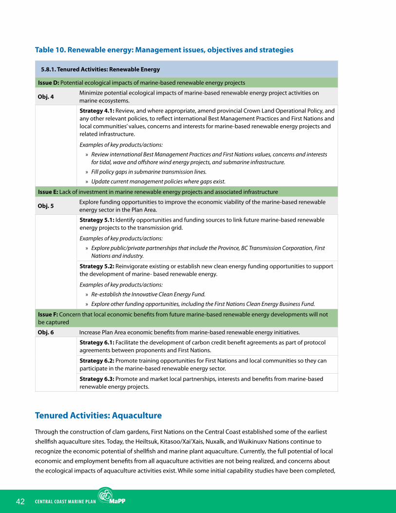
42 CENTRAL COAST MARINE PLAN
Table 10. Renewable energy: Management issues, objectives and strategies
5.8.1. Tenured Activities: Renewable Energy
Issue D: Potential ecological impacts of marine-based renewable energy projects
Obj. 4Minimize potential ecological impacts of marine-based renewable energy project activities on marine ecosystems.
Strategy 4.1: Review, and where appropriate, amend provincial Crown Land Operational Policy, and any other relevant policies, to reflect international Best Management Practices and First Nations and local communities’ values, concerns and interests for marine-based renewable energy projects and related infrastructure.
Examples of key products/actions:
» Review international Best Management Practices and First Nations values, concerns and interests for tidal, wave and offshore wind energy projects, and submarine infrastructure.
» Fill policy gaps in submarine transmission lines.
» Update current management policies where gaps exist.
Issue E: Lack of investment in marine renewable energy projects and associated infrastructure
Obj. 5Explore funding opportunities to improve the economic viability of the marine-based renewable energy sector in the Plan Area.
Strategy 5.1: Identify opportunities and funding sources to link future marine-based renewable energy projects to the transmission grid.
Examples of key products/actions:
» Explore public/private partnerships that include the Province, BC Transmission Corporation, First Nations and industry.
Strategy 5.2: Reinvigorate existing or establish new clean energy funding opportunities to support the development of marine- based renewable energy.
Examples of key products/actions:
» Re-establish the Innovative Clean Energy Fund.
» Explore other funding opportunities, including the First Nations Clean Energy Business Fund.
Issue F: Concern that local economic benefits from future marine-based renewable energy developments will not be captured
Obj. 6 Increase Plan Area economic benefits from marine-based renewable energy initiatives.
Strategy 6.1: Facilitate the development of carbon credit benefit agreements as part of protocol agreements between proponents and First Nations.
Strategy 6.2: Promote training opportunities for First Nations and local communities so they can participate in the marine-based renewable energy sector.
Strategy 6.3: Promote and market local partnerships, interests and benefits from marine-based renewable energy projects.
Tenured Activities: Aquaculture
Through the construction of clam gardens, First Nations on the Central Coast established some of the earliest shellfish aquaculture sites. Today, the Heiltsuk, Kitasoo/Xai’Xais, Nuxalk, and Wuikinuxv Nations continue to recognize the economic potential of shellfish and marine plant aquaculture. Currently, the full potential of local economic and employment benefits from all aquaculture activities are not being realized, and concerns about the ecological impacts of aquaculture activities exist. While some initial capability studies have been completed,

43ChAPTER 5: MANAgEMENT DIREC TION
optimal sites for aquaculture development have not yet been identified and proactive management measures are needed to ensure these sites are not used for conflicting uses and activities.
As of August, 2014, there were six active sites for finfish aquaculture for Atlantic salmon in the Plan Area, including two tenures that are in the process of applying for renewal. There is also a tenured finfish hatchery at Ocean Falls. Most of these tenures are near Klemtu and associated operations provide economic benefits and employment for some local communities. Finfish aquaculture is the largest year-round employer for the Kitasoo/ Xai’Xais Nation.
Order-in-Council number 174, a provincial moratorium on marine finfish aquaculture tenures in tidal waters north of Aristazabal Island has been in place since 2008. The province is supportive of the expansion of finfish aquaculture in areas outside of the moratorium as long as they are appropriately sited and have First Nations support. While existing operations do provide economic benefits to the area, there is little First Nations support for the expansion of finfish aquaculture in the Plan Area.
As of May 2014, there was one active shellfish tenure in the Central Coast Plan Area, located in Peter Bay near Bella Bella. As of May 2014, there was no marine plant aquaculture in the Plan Area. There is broad support for shellfish aquaculture in the Plan Area. The Central Coast has high biophysical capability for shellfish and marine plant aquaculture, but this industry is still in the early stages of development.
Management direction for aquaculture (Table 11) aims to maintain opportunities for the aquaculture industry and increase local economic benefits from aquaculture activities while addressing current and potential negative ecological impacts.
Table 11. Aquaculture: Management issues, objectives and strategies
5.8.2. Tenured Activities: Aquaculture
Issue G: Current and potential ecological impacts of aquaculture activities
Obj. 7 Minimize current and potential ecological impacts of aquaculture activities on marine ecosystems.
Strategy 7.1: Work with relevant Crown agencies and First Nations to review and, where appropriate, amend the provincial Land Use Operational Policy and any other relevant policy for aquaculture, to reflect international Best Management Practices and First Nations values, concerns and interests.
Examples of key products/actions:
» Develop, or review existing, aquaculture siting policy to ensure it reflects international Best Management Practices and First Nations values and interests.
Issue H: Lack of investment in shellfish and marine plant aquaculture
Obj. 8 Improve the financial viability of shellfish and marine plant aquaculture.
Strategy 8.1: Promote shellfish and marine plant aquaculture processing and value-added initiatives.
Strategy 8.2: Identify new and expandable export markets for Central Coast shellfish and marine plant aquaculture products.
Strategy 8.3: Work with relevant Crown agencies and First Nations, to review regulatory regimes for shellfish aquaculture to identify opportunities for streamlining.

44 CENTRAL COAST MARINE PLAN
5.8.2. Tenured Activities: Aquaculture
Issue I: Full potential of local economic benefits from aquaculture is not being realized
Obj. 9 Increase Plan Area economic benefits from aquaculture initiatives.
Strategy 9.1: Create and advertise training and development programs that fill skill gaps and enable Plan Area residents to be employable in the aquaculture sector.
Strategy 9.2: Encourage First Nations and local ownership and operation of aquaculture tenures.
Examples of key products/actions:
» Programs and partnerships that help address issues around capacity, economies of scale, financing, start-up costs.
» Setting aside areas for First Nations economic development via the Coastal First Nations Reconciliation Protocol.
Strategy 9.3: Prepare a review of infrastructure requirements for First Nations and local communities processing of aquaculture products in cooperation with relevant government agencies, industry and stakeholders.
Examples of key products/actions:
» Create an action plan for developing infrastructure required for processing aquaculture products.
Strategy 9.4: Address priority infrastructure gaps in cooperation with relevant government agencies, industry and stakeholders.
Examples of key products/actions:
» Implement the action plan developed through Strategy 9.3.
Issue J: Need to identify optimal sites for aquaculture
Obj. 10 Identify optimal sites for aquaculture development.
Strategy 10.1: Crown agencies and First Nations to work with relevant stakeholders to conduct detailed planning that identifies optimal sites for aquaculture.
Examples of key products/actions:
» Conduct operational site suitability assessments to identify optimal sites within the Aquaculture Special Management Zones.
Tenured Activities: Forestry Operations
Marine-based forestry operations are a critical component of coastal logging operations because the remote location and mountainous terrain precludes the cost-effective transportation of logs on land. Almost all of the timber harvested on the Central Coast is moved into the water through designated distribution points, where it is transported by tug and/or barge to sort yards, mills and shipping ports for further manufacturing or export.
As of May 2014, there were 57 active log handling and storage tenures on the Central Coast; however, most sites are active only periodically.
In the past, marine-based forestry operations often damaged fish and wildlife habitat due to poor site selection and operational procedures. Current site selection and operational procedures seek to minimize ecological impacts, though concerns about ecological impacts remain.
Management direction for forestry operations (Table 12) focuses on reducing current and potential ecological impacts of forestry operations in marine areas.
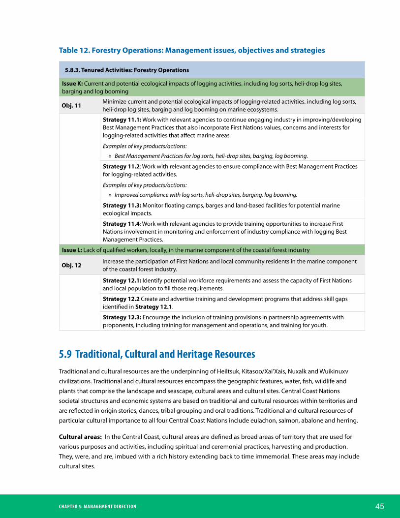
45ChAPTER 5: MANAgEMENT DIREC TION
Table 12. Forestry Operations: Management issues, objectives and strategies
5.8.3. Tenured Activities: Forestry Operations
Issue K: Current and potential ecological impacts of logging activities, including log sorts, heli-drop log sites, barging and log booming
Obj. 11Minimize current and potential ecological impacts of logging-related activities, including log sorts, heli-drop log sites, barging and log booming on marine ecosystems.
Strategy 11.1: Work with relevant agencies to continue engaging industry in improving/developing Best Management Practices that also incorporate First Nations values, concerns and interests for logging-related activities that affect marine areas.
Examples of key products/actions:
» Best Management Practices for log sorts, heli-drop sites, barging, log booming.
Strategy 11.2: Work with relevant agencies to ensure compliance with Best Management Practices for logging-related activities.
Examples of key products/actions:
» Improved compliance with log sorts, heli-drop sites, barging, log booming.
Strategy 11.3: Monitor floating camps, barges and land-based facilities for potential marine ecological impacts.
Strategy 11.4: Work with relevant agencies to provide training opportunities to increase First Nations involvement in monitoring and enforcement of industry compliance with logging Best Management Practices.
Issue L: Lack of qualified workers, locally, in the marine component of the coastal forest industry
Obj. 12Increase the participation of First Nations and local community residents in the marine component of the coastal forest industry.
Strategy 12.1: Identify potential workforce requirements and assess the capacity of First Nations and local population to fill those requirements.
Strategy 12.2 Create and advertise training and development programs that address skill gaps identified in Strategy 12.1.
Strategy 12.3: Encourage the inclusion of training provisions in partnership agreements with proponents, including training for management and operations, and training for youth.
5.9 Traditional, Cultural and heritage ResourcesTraditional and cultural resources are the underpinning of Heiltsuk, Kitasoo/Xai’Xais, Nuxalk and Wuikinuxv civilizations. Traditional and cultural resources encompass the geographic features, water, fish, wildlife and plants that comprise the landscape and seascape, cultural areas and cultural sites. Central Coast Nations societal structures and economic systems are based on traditional and cultural resources within territories and are reflected in origin stories, dances, tribal grouping and oral traditions. Traditional and cultural resources of particular cultural importance to all four Central Coast Nations include eulachon, salmon, abalone and herring.
Cultural areas: In the Central Coast, cultural areas are defined as broad areas of territory that are used for various purposes and activities, including spiritual and ceremonial practices, harvesting and production. They, were, and are, imbued with a rich history extending back to time immemorial. These areas may include cultural sites.

46 CENTRAL COAST MARINE PLAN
Cultural sites: In the Central Coast, cultural sites are defined as specific locations of territory and reflect a rich history extending back to time immemorial. Examples of cultural sites in the Plan Area include, but are not limited to, village sites, seasonal camps, shell middens, fish weirs and traps, clam gardens, gravesites, ceremonial sites, spiritual sites, and pictographs and petroglyphs that depict legends and stories. Cultural sites and the objects they contain are precious to First Nations, are fragile and vulnerable to impact from human behavior and changes in the ecosystem, and care must be taken to protect them.
Heritage sites: are usually linked to the more recent history of the Central Coast Plan Area (i.e., the arrival and settlement of non-Aboriginal peoples). They include marine heritage sites, such as lighthouses, canneries, shipwrecks, dry docks and boatsheds, in addition to coastal sawmills, mines, historical railway infrastructure and the remnants and sites of this type of early industrial development, as well as the residences of early settlers.
Archaeological sites: are areas where archaeological investigations have occurred and can include either cultural sites or heritage sites.
Gaps in information about cultural and archaeological sites exist throughout the Plan Area. Heiltsuk, Kitasoo/Xai’Xais, Nuxalk and Wuikinuxv First Nations are pursuing collaborative research opportunities to survey sites in their territories and are exploring opportunities to protect these sites and develop management plans.
The Central Coast Marine Plan is intended to promote and sustain Traditional and cultural resources and provide opportunities for Traditional use by current and future generations. Management direction in Table 13 focuses on protecting cultural sites and cultural areas within territories.
Table 13. Traditional, cultural and heritage resources: Management issues, objectives and strategies
5.9. Traditional, Cultural and Heritage Resources
Issue A: Degradation of cultural and archaeological sites because of inadequate protection measures
Obj. 1 Enhance protection measures for sensitive cultural and archaeological sites in the Plan Area.
Strategy 1.1: Incorporate the protection of sensitive cultural and archaeological sites into the management of PMZs.
Strategy 1.2: Develop site management and/or restoration plans for highly sensitive cultural and archaeological sites that include temporal and/or spatial limits to human access, if necessary.
Examples of key products/actions:
» Management plans for highly sensitive sites.
Strategy 1.3: To the extent possible, locate marine recreation sites away from sensitive cultural and archaeological sites.
Examples of key products/actions:
» New recreation sites are located away from highly sensitive sites.
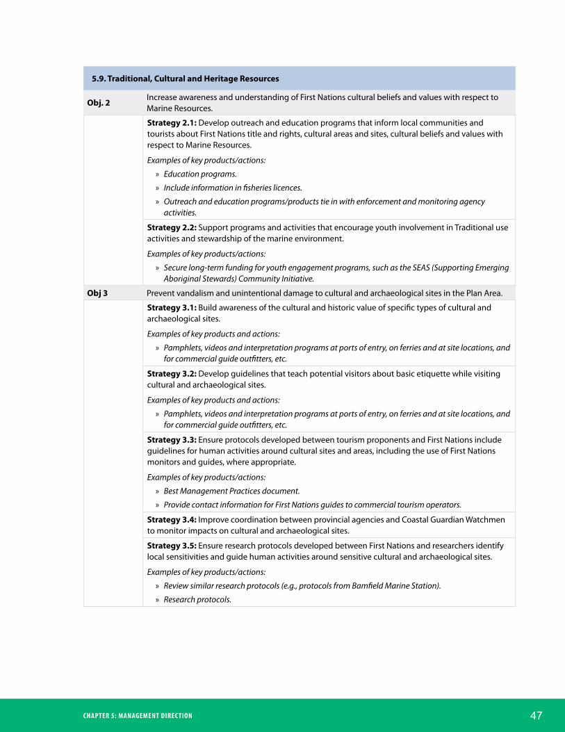
47ChAPTER 5: MANAgEMENT DIREC TION
5.9. Traditional, Cultural and Heritage Resources
Obj. 2Increase awareness and understanding of First Nations cultural beliefs and values with respect to Marine Resources.
Strategy 2.1: Develop outreach and education programs that inform local communities and tourists about First Nations title and rights, cultural areas and sites, cultural beliefs and values with respect to Marine Resources.
Examples of key products/actions:
» Education programs.
» Include information in fisheries licences.
» Outreach and education programs/products tie in with enforcement and monitoring agency activities.
Strategy 2.2: Support programs and activities that encourage youth involvement in Traditional use activities and stewardship of the marine environment.
Examples of key products/actions:
» Secure long-term funding for youth engagement programs, such as the SEAS (Supporting Emerging Aboriginal Stewards) Community Initiative.
Obj 3 Prevent vandalism and unintentional damage to cultural and archaeological sites in the Plan Area.
Strategy 3.1: Build awareness of the cultural and historic value of specific types of cultural and archaeological sites.
Examples of key products and actions:
» Pamphlets, videos and interpretation programs at ports of entry, on ferries and at site locations, and for commercial guide outfitters, etc.
Strategy 3.2: Develop guidelines that teach potential visitors about basic etiquette while visiting cultural and archaeological sites.
Examples of key products and actions:
» Pamphlets, videos and interpretation programs at ports of entry, on ferries and at site locations, and for commercial guide outfitters, etc.
Strategy 3.3: Ensure protocols developed between tourism proponents and First Nations include guidelines for human activities around cultural sites and areas, including the use of First Nations monitors and guides, where appropriate.
Examples of key products/actions:
» Best Management Practices document.
» Provide contact information for First Nations guides to commercial tourism operators.
Strategy 3.4: Improve coordination between provincial agencies and Coastal Guardian Watchmen to monitor impacts on cultural and archaeological sites.
Strategy 3.5: Ensure research protocols developed between First Nations and researchers identify local sensitivities and guide human activities around sensitive cultural and archaeological sites.
Examples of key products/actions:
» Review similar research protocols (e.g., protocols from Bamfield Marine Station).
» Research protocols.

48 CENTRAL COAST MARINE PLAN
5.9. Traditional, Cultural and Heritage Resources
Issue B: Improper recording of cultural sites and areas because of concerns about how sensitive data are handled
Obj. 4Develop a framework for reporting cultural sites and areas to relevant provincial agencies and First Nations integrated resource management bodies.
Strategy 4.1: Improve security for sensitive data.
Examples of key products/actions:
» Framework for reporting cultural sites and archaeological sites.
Strategy 4.2: Enhance the ability of First Nations to use information about cultural sites and areas.
Issue C: Gaps in information about cultural and archaeological sites
Obj. 5 Identify cultural sites through additional surveys and better access to existing research.
Strategy 5.1: Identify funding and partnership opportunities in order to prioritize and conduct additional surveys of cultural sites and areas.
Strategy 5.2: Establish or build upon databases for cultural and archaeological research projects.
5.10 Tourism and RecreationThe marine tourism and recreation sector includes commercial and public non-extractive recreation and tourism activities that occur in the marine environment, such as whale watching, nature viewing, boating/cruising, scuba diving, kayaking and canoeing. While tourism and recreation participants often fish recreationally, public and commercial recreational fishing is discussed in Section 5.11 (Marine Fisheries Economy).
People who participate in marine recreation and tourism are either local residents or tourists (80 km or more from home). Those who participate in commercial recreation and tourism pay business operators for services that include guiding, crewed boats, destination resorts and interpretation. Customers are typically tourists, but local residents may purchase the services of a guide as well. Public recreation does not involve paying a guide, and similar to commercial recreation and tourism, both tourists and locals can participate in activities where public recreation is permissible.
The strength of the Central Coast marine tourism and recreation sector lies in its competitive advantage regarding visitor experience. The coastal setting, scenery, cultural history and unique communities of the region provide a world class setting for marine recreation and tourism activities. However, ferry and air transportation to, from and within the Plan Area is expensive, time consuming, and can be irregular during the winter. Accommodation options are limited, and there are very few organised activities for visitors. While ample opportunities exist, resources to develop this sector in a manner that benefits local communities in the Central Coast are lacking.
Management direction for marine tourism and recreation (Table 14) intends to increase economic opportunities for local communities and ensure any negative impacts on wildlife, natural areas and user groups are minimized.
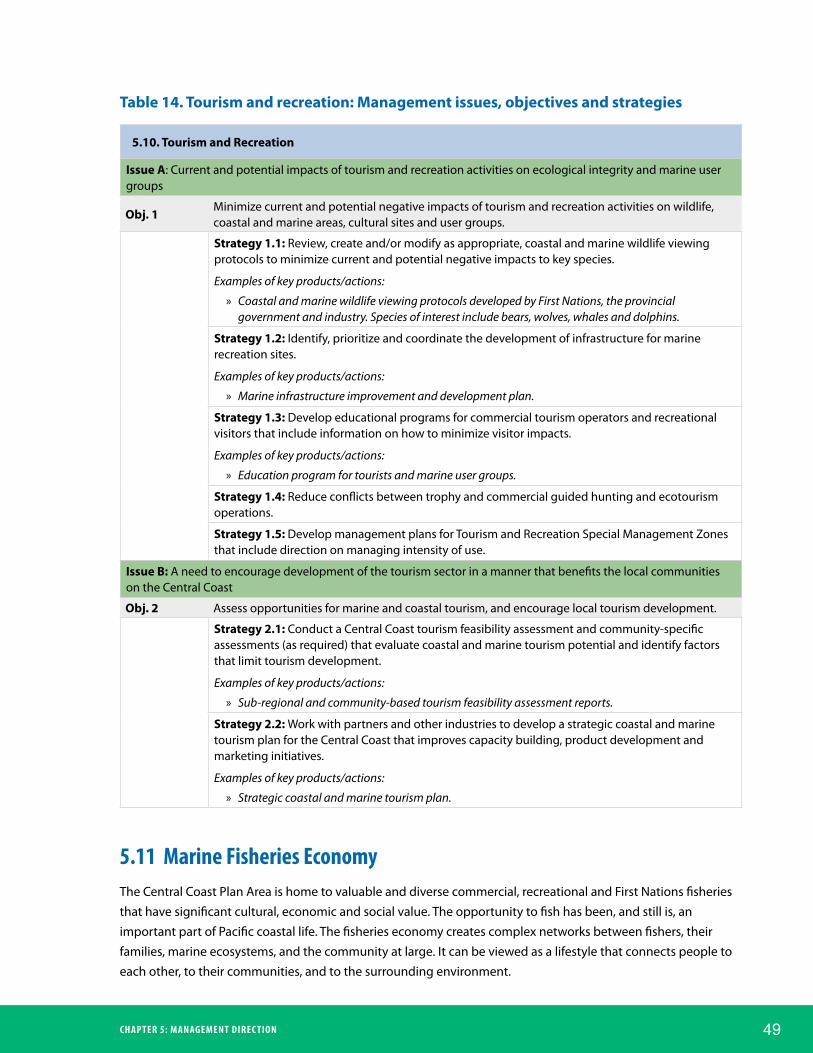
49ChAPTER 5: MANAgEMENT DIREC TION
Table 14. Tourism and recreation: Management issues, objectives and strategies
5.10. Tourism and Recreation
Issue A: Current and potential impacts of tourism and recreation activities on ecological integrity and marine user groups
Obj. 1Minimize current and potential negative impacts of tourism and recreation activities on wildlife, coastal and marine areas, cultural sites and user groups.
Strategy 1.1: Review, create and/or modify as appropriate, coastal and marine wildlife viewing protocols to minimize current and potential negative impacts to key species.
Examples of key products/actions:
» Coastal and marine wildlife viewing protocols developed by First Nations, the provincial government and industry. Species of interest include bears, wolves, whales and dolphins.
Strategy 1.2: Identify, prioritize and coordinate the development of infrastructure for marine recreation sites.
Examples of key products/actions:
» Marine infrastructure improvement and development plan.
Strategy 1.3: Develop educational programs for commercial tourism operators and recreational visitors that include information on how to minimize visitor impacts.
Examples of key products/actions:
» Education program for tourists and marine user groups.
Strategy 1.4: Reduce conflicts between trophy and commercial guided hunting and ecotourism operations.
Strategy 1.5: Develop management plans for Tourism and Recreation Special Management Zones that include direction on managing intensity of use.
Issue B: A need to encourage development of the tourism sector in a manner that benefits the local communities on the Central Coast
Obj. 2 Assess opportunities for marine and coastal tourism, and encourage local tourism development.
Strategy 2.1: Conduct a Central Coast tourism feasibility assessment and community-specific assessments (as required) that evaluate coastal and marine tourism potential and identify factors that limit tourism development.
Examples of key products/actions:
» Sub-regional and community-based tourism feasibility assessment reports.
Strategy 2.2: Work with partners and other industries to develop a strategic coastal and marine tourism plan for the Central Coast that improves capacity building, product development and marketing initiatives.
Examples of key products/actions:
» Strategic coastal and marine tourism plan.
5.11 Marine fisheries EconomyThe Central Coast Plan Area is home to valuable and diverse commercial, recreational and First Nations fisheries that have significant cultural, economic and social value. The opportunity to fish has been, and still is, an important part of Pacific coastal life. The fisheries economy creates complex networks between fishers, their families, marine ecosystems, and the community at large. It can be viewed as a lifestyle that connects people to each other, to their communities, and to the surrounding environment.

50 CENTRAL COAST MARINE PLAN
Commercial fishing has been declining in the Central Coast Plan Area in recent years as a result of many factors. The socio-economic impacts of this decline have been intensified by a decreasing number of locally owned and operated commercial fishing licences and reduced critical marine fisheries infrastructure, such as processing plants. While First Nations and local participation in commercial fisheries has decreased over the last 20 years, the re-establishment of community-based fisheries, (including processing, marketing and management) which focus on increased First Nation and local participation will be a key driver in social, cultural and economic wellbeing for First Nations and local communities.
Over the last 50 years, the regional and global seafood industry has become increasingly competitive and BC industries have had to adapt and reposition. Traceability and sustainability, through eco-labelling programs, dockside monitoring programs and fisheries vessel observer programs are becoming business requirements in the industry, reflecting a growing environmental ethic and enabling better access to international markets.
The ability to serve high-quality, high-value seafood to market requires proper orientation and cooperation by all the elements in the value chain, from fisheries managers and regulators to harvesters and growers to processors and distributors. Additional investments in infrastructure, equipment, product development and human resources (i.e., training) can help to ensure long-term viability of the seafood sector.
The number and capacity of privately operated fishing lodges in the Plan Area has been declining since 2008. This trend is largely the result of a decline in the American economy, the stronger Canadian dollar, and escalating fuel costs. Despite this decline, the recreational fishing sector contributes significantly to the local and provincial economy.
The impact of recreational fisheries on local fish stocks and the ability of First Nations to harvest Marine Resources remains a concern. Heiltsuk, Kitasoo/Xai’Xais, Nuxalk and Wuikinuxv Traditional fishing and the harvest of Marine Resources occurs throughout the Central Coast and is an important aspect of their way of life. Continuity of fishing and the harvest of Marine Resources, including cultural fishing practices and activities, are critical to the future of Heiltsuk, Kitasoo/Xai’Xais, Nuxalk and Wuikinuxv communities. Improving Traditional
Photo by Ian McAllister

51ChAPTER 5: MANAgEMENT DIREC TION
fishing and harvesting security and reducing conflict between Traditional fishing activities and other fishers and harvesters are integral to supporting the Central Coast Nations’ culture and wellbeing.
Management direction for the marine fisheries economy (Table 15) intends to reduce conflict between participants in the fisheries economy and other marine uses and activities, minimize ecological and cultural impacts from sport fishing lodges, increase enhancement and restoration activities, and increase local economic benefits from fisheries and other seafood processing activities.
Table 15. Marine fisheries economy: Management issues, objectives and strategies
5.11. Marine Fisheries Economy
Issue A: Current and potential ecological and cultural impacts from sport fishing lodges
Obj. 1Avoid, reduce and mitigate the current and potential impacts of commercial sport fishing lodges on the marine environment and First Nations cultural resources.
Strategy 1.1: Work with relevant Crown agencies and First Nations to assess the need, and where appropriate, develop a siting policy for marine-based sport fishing lodges that incorporates traditional and local knowledge and values and considers cumulative effects.
Strategy 1.2: Develop education programs that inform lodge boat operators of rules about resource stewardship and best practices.
Obj. 2Establish regulations to manage untenured floating lodges and passenger vessels operating as sport fishing lodges.
Strategy 2.1: Work with relevant agencies to assess the feasibility, and where appropriate, align regulations for untenured sport fishing vessels and tenured sport fishing lodges.
Examples of key products/actions:
» Policy that covers untenured sport fishing vessels and includes:
» reporting requirements, including catch numbers.
» e.g. bringing siting and disposal of refuse standards in line with tenured operations.
Issue B: Lack of education and communication about Central Coast First Nations cultural beliefs and values with respect to Marine Resources
Obj. 3Increase awareness and understanding of First Nations cultural beliefs and values with respect to Marine Resources.
Strategy 3.1: Develop outreach and education programs that inform recreational fishers about First Nations rights, cultural beliefs and values with respect to Marine Resources.
Examples of key actions/products:
» Education programs.
» Include information in fisheries licences.
» Outreach and education programs/products tie in with enforcement and monitoring agency activities. Programs include education for the general public about protocol agreements between First Nations and operators.
Strategy 3.2: Support the inclusion of elements that avoid or mitigate impacts and increase awareness of First Nations cultural beliefs and values with respect to Marine Resources in protocol agreements developed between First Nations and recreational fishing service providers.

52 CENTRAL COAST MARINE PLAN
5.11. Marine Fisheries Economy
Issue C: Impacts from commercial and recreational fishing to marine ecosystems that have high ecological, social, cultural or economic value
Obj. 4Increase enhancement and restoration activities for fish populations that have high ecological, social, cultural or economic value, and the marine habitats that support them.
Strategy 4.1: Develop a summary report of all the enhancement and restoration activities occurring in the Plan Area.
Strategy 4.2: Identify gaps in enhancement and restoration activities based on ecological, social and economic need.
Examples of key products/actions:
» Identify fish and marine resource populations that have high ecological, social, cultural or economic value, and the marine habitats that support them.
Strategy 4.3. Quantify the economic and social benefits of salmon restoration activities, including effects on recreational fishing and commercial fishing.
Strategy 4.4: Seek additional funding to fill gaps in enhancement and restoration activities identified in Strategy 4.2.
Examples of key products/actions:
» Where ecological, social or economic need exists, restoration activities are increased.
Issue D: Declining local participation in commercial fisheries and seafood processing activities
Obj. 5Increase First Nations and local community job opportunities in the fisheries sector on the Central Coast.
Strategy 5.1: Explore opportunities for First Nations and local community investment, partnership and participation in seafood processing and other value-added activities.
Examples of key products/actions:
» Evaluation of barriers and opportunities for investment and partnership opportunities.
» Feasibility study for value-added seafood products.
» Skill gap assessment and resultant training program.
Strategy 5.2: Create and advertise training and development programs that fill skill gaps and enable Plan Area residents to be employable in the commercial fisheries sector.
Obj. 6 Support branding and marketing of local, sustainable, seafood products.
Strategy 6.1: Expand and promote participation in seafood traceability and/or certification programs, such as ThisFish, that focus on reducing poaching and adding commercial value to sustainably caught seafood.
Examples of key products/actions:
» Work with traceability and/or certification programs and local harvesters to expand seafood traceability and/or certification programs to include Central Coast fisheries.
Strategy 6.2: Market Plan Area fisheries that have been certified as sustainably harvested.
Examples of key products/actions:
» Marketing and branding plan.
» Develop criteria to identify applicable traceability and/or certification programs.
Strategy 6.3: Promote seafood processing and value-added initiatives developed through Strategies 6.1 and 6.2.
Strategy 6.4: Identify new and expandable export markets for Central Coast seafood products.
Examples of key products/actions:
» Analysis identifying new and expandable export markets.

53ChAPTER 5: MANAgEMENT DIREC TION
5.11. Marine Fisheries Economy
Issue E: Lack of local economic benefit from recreational fishing activities
Obj. 7 Increase Plan Area economic benefits from sport fishing lodges.
Strategy 7.1: Facilitate development and implementation of protocol agreements between First Nations and recreational fishery service providers, where appropriate.
Strategy 7.2: Create and advertise training and development programs that fill skill gaps and enable Plan Area residents to be employable in the recreational fishery services sector.
Photo by Julie Carpenter

54 CENTRAL COAST MARINE PLAN
ChAPTER 6: MARINE SPATIAL PLAN
The designation of marine space into discrete zones is a common component of integrated ocean and marine plans. This practice is consistent with strategic land use planning in BC, which allocates space to specific zones to alleviate competition and conflict and/or identify priority uses and values.
All four of the sub-regional marine plans developed through the MaPP initiative include zoning designations. Representatives from the four MaPP Sub-regional Technical Teams worked together to ensure that zoning designations in all of the sub-regional marine plans were developed and applied consistently across the MaPP study area. The teams followed a number of key steps when developing zones and recommended uses for the MaPP study area. Spatial planning in the Central Coast Plan Area followed the steps outlined in Figure 7.
Photo by Ian McAllister

55ChAPTER 6: MARINE SPATIAL PLAN
Step 1: Confirmation of Zoning Approach
Step 2: Confirmation and Analysis of Spatial Data
Step 3: Development of Decision-Support Tools
Step 4: Development of Preliminary Spatial Plan
Step 5: Review and Finalisation of Spatial Plan
figure 7. key steps followed during spatial planning
Step 1: Confirmation of Zoning Approach
» Agreement on a Regional Zoning Framework that confirmed MaPP principles for establishing zones, described zoning scale, listed zoning objectives and described zone designations (General Management Zones, Special Management Zones and Protection Management Zones)
» Agreement on the types of Special Management Zone categories and Protection Management Zone categories that would be designated in the Central Coast Plan Area
» Development of Recommended Uses and Activities Tables for each type of zone and zone category
Step 2: Compilation and Analysis of Spatial Data
» Data collection and verification
» Identification of primary data layers to be used in spatial planning
» Spatial data overlay analysis to identify conflicts and areas of high value for particular uses and activities
Step 3: Development of Decision-Support Tools
» Creation of a MaPP web-mapping portal to display, evaluate and overlay spatial data
» Development of a compatibility matrix to assess the compatibility of two different human uses or activities that are occurring at the same time and location
» Development of a vulnerability matrix to provide information on the vulnerability of marine ecosystems to particular marine stressors
» Creation of maps and reports on ecosystem vulnerability to climate change
» Creation of maps and reports on ecosystem vulnerability to pollution
» Creation of sub-regional and regional Marxan scenarios to identify spatial areas with high conservation value
Step 4: Development of Preliminary Spatial Plan
» Joint workshops held between First Nations and the Province to develop zone placement
» Refinement of zone-specific Recommended Uses and Activities Tables and management provisions/conditions for zones and zone categories

56 CENTRAL COAST MARINE PLAN
Step 5: Review and Finalisation of Spatial Plan
» Draft zones uploaded to MaPP web-mapping portal and made accessible to MPAC
» Consideration of MPAC member advice by technical staff representing the Heiltsuk, Kitasoo/Xai’Xais, Nuxalk and Wuikinuxv Nations and the Province
» First Nations and provincial internal review of zones and Recommended Uses and Activities Tables to ensure alignment with First Nations and provincial direction
» Zones and Recommended Uses and Activities Tables revised and incorporated into the draft Central Coast Marine Plan
» Revised draft zones made accessible to the general public on the MaPP web-mapping portal during the public review period
6.1 Zoning DescriptionsThe Central Coast Marine Plan has three overarching zones1 based on the MaPP Zoning Framework: General Management Zones, Special Management Zones (and associated categories) and Protection Management Zones (and associated categories). All spatial recommendations in this Marine Plan provide policy guidance intended to inform the decision making process regarding uses and activities in the areas identified. The PMZs recommended in this Marine Plan are not designating Marine Protected Areas (MPAs). The appropriate policy and legal instruments for achieving stated zoning objectives will be determined during plan implementation. Each of these zone types is discussed briefly below.
Table 16. MaPP Zoning Framework: Zone type, description and objective
Zone Type Description Objective
General Management Zone (GMZ)
Allocates space for a wide range of marine uses and activities that are governed or managed using an EBM framework. The GMZ recognizes that many coastal or marine areas have no over-arching priorities for uses or activities, and that a large number of activities do not have spatial or temporal conflicts. Where conflicts may occur, they can be addressed through proper management prescriptions in combination with the general management direction (i.e., objectives and strategies) of the sub-regional marine plans, including prohibitions and exceptions for activities that occur on the seabed, pelagic or surface areas.
To manage for a variety of present and potential future marine uses and activities that adhere to ecosystem-based management (EBM) principles; multiple uses and activities are permitted where compatible in time and space.
1 There are five areas that have not been assigned a zone type. A variety of ecological, economic, cultural and social values will be considered through more detailed planning for these zones (see Strategy 3.3 in Section 5.8 of the plan).

57ChAPTER 6: MARINE SPATIAL PLAN
Zone Type Description Objective
Special Management Zone (SMZ)
Allocates space for high priority and/or high potential marine uses and activities including economic development and/or cultural uses and activities that require specific environmental conditions or locations. To avoid temporal or spatial conflicts and competition with certain other uses and activities, special management prescriptions are applied in addition to the general management direction (i.e., objectives and strategies) of the sub-regional marine plans.
To manage for one or more identified high priority and/or high potential marine uses or activities. Additional uses and activities are permitted only where compatible in time and space with the high priority and/or high potential use or activity.
Protection Management Zone (PMZ)
Allocates space primarily for conservation purposes or objectives, and may provide a basis for protecting localized conservation values. The Protection Management Zones (PMZs) recommended in this marine plan are not designating Marine Protected Areas (MPAs) and do not provide recommendations on marine uses and activities outside of provincial regulatory authority. PMZs will make important contributions to the MPA network planning process for the Northern Shelf Bioregion and are subject to further consultation and evaluation through that process.
To conserve and/or protect the range of values that marine environments provide with a primary emphasis on maintaining marine biodiversity, ecological representation and special features (e.g., sponge reefs, seamounts, pinniped haulout sites or rookeries, and significant foraging grounds for species).
Special Management Zone Categories
a. Aquaculture Special Management Zone
The management intent of this category places an emphasis on the development of the aquaculture industry as appropriate. First Nations Traditional uses and practices, including for food, social and ceremonial purposes continue throughout this zone.
b. Recreation and Tourism Special Management Zone
The management intent of this category places an emphasis on ecosystem-based recreation and tourism activities and uses. Maintaining visual quality and eco-tourism opportunities is the primary objective of the Recreation and Tourism SMZ. Significant public marine recreational use and activity occurs in this zone, including anchorages, kayaking and boating routes, whale watching and bear viewing. First Nations Traditional uses and practices, including for food, social and ceremonial purposes, continue throughout this zone.
c. Renewable Energy Special Management Zone
The management intent for this category places an emphasis on the growth and development of the renewable energy industry. First Nations Traditional uses and practices, including for food, social and ceremonial purposes, continue throughout this zone.
Protection Management Zone Categories
The categories in the PMZ align with Guidelines for Applying the IUCN Protected Area Management Categories to Marine Protected Areas. The IUCN categories were used to:
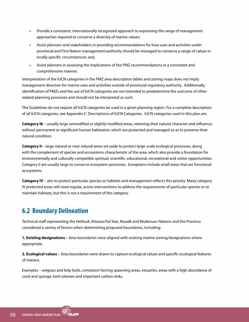
58 CENTRAL COAST MARINE PLAN
» Provide a consistent, internationally recognized approach to expressing the range of management approaches required to conserve a diversity of marine values;
» Assist planners and stakeholders in providing recommendations for how uses and activities under provincial and First Nation management/authority should be managed to conserve a range of values in locally specific circumstances; and,
» Assist planners in assessing the implications of the PMZ recommendations in a consistent and comprehensive manner.
Interpretation of the IUCN categories in the PMZ area description tables and zoning maps does not imply management direction for marine uses and activities outside of provincial regulatory authority. Additionally, identification of PMZs and the use of IUCN categories are not intended to predetermine the outcome of other related planning processes and should not be interpreted as such.
The Guidelines do not require all IUCN categories be used in a given planning region. For a complete description of all IUCN categories, see Appendix C: Descriptions of IUCN Categories. IUCN categories used in this plan are:
Category Ib – usually large unmodified or slightly modified areas, retaining their natural character and influence, without permanent or significant human habitation, which are protected and managed so as to preserve their natural condition.
Category II – large natural or near natural areas set aside to protect large-scale ecological processes, along with the complement of species and ecosystems characteristic of the area, which also provide a foundation for environmentally and culturally compatible spiritual, scientific, educational, recreational and visitor opportunities. Category II are usually large to conserve ecosystem processes. Exceptions include small areas that are functional ecosystems.
Category IV – aim to protect particular species or habitats and management reflects this priority. Many category IV protected areas will need regular, active interventions to address the requirements of particular species or to maintain habitats, but this is not a requirement of the category.
6.2 boundary Delineation Technical staff representing the Heiltsuk, Kitasoo/Xai’Xais, Nuxalk and Wuikinuxv Nations and the Province considered a variety of factors when determining proposed boundaries, including:
1. Existing designations – Area boundaries were aligned with existing marine zoning/designations where appropriate.
2. Ecological values – Area boundaries were drawn to capture ecological values and specific ecological features of interest.
Examples – eelgrass and kelp beds, consistent herring spawning areas, estuaries, areas with a high abundance of coral and sponge, bird colonies and important carbon sinks.

59ChAPTER 6: MARINE SPATIAL PLAN
3. Cultural and Traditional use values – Area boundaries were drawn to capture important cultural and Traditional use areas that require spatial protection. Protection of certain prioritized areas does not mean that other areas are not important.
Examples – sensitive locations, including those of cultural and spiritual importance, important food gathering areas, village site locations
4. Current uses and activities – Area boundaries were drawn to minimize conflict and ensure continued economic opportunities in the region based on the evaluation of current uses and activities.
5. Future economic opportunities – Area boundaries were drawn to facilitate future economic opportunities in the region based on the evaluation of potential future uses and activities.
Examples – high value sites for marine-based renewable energy, shellfish aquaculture capability, forestry operations, and recreation and tourism opportunity
6. Adjacent land use – Area boundaries considered adjacent land use to maximise compatibility between proposed zones and terrestrial areas.
Examples – private land, existing terrestrial tenures, parks and protected areas
7. Results of Marxan analyses – The delineation of area boundaries was informed by results from sub-regional Marxan analyses that used spatial data sets compiled by the British Columbia Marine Conservation Analysis to identify areas of high conservation value and representative areas of biodiversity.
8. Ease of identification, navigation and management – Area boundaries were designed to facilitate easy identification and navigation on the water, and for compliance and enforcement purposes.
Examples – straight lines, jaws of land (boundary established between two visible terrestrial points), half-moon boundaries around salmon-bearing streams
6.3 Recommended uses and Activities within ZonesRecommended Uses and Activities Tables were created for each zone in the Central Coast Marine Plan. The tables identify the acceptable (A), conditionally acceptable (C), or not acceptable (N) uses and activities for a particular zone (Table 17).
Conditionally acceptable activities have specific management conditions which are provided in the conditional statement tables that follow the Recommended Uses and Activities Tables. Many conditional statements refer to Protection Management Plans that will be developed in the future. Until Protection Management Plans are developed, conditional activities will have to meet existing legislation and policy and consider local cultural and ecological values. Protection Management Plans may outline additional requirements. Constructive dialogue between sectors is encouraged in order to meet many of the conditions outlined for the zones, including in SMZs where potential conflicts between sectors may occur.

60 CENTRAL COAST MARINE PLAN
Request for variance to a zoning requirement will be reviewed by the Province of BC and the Heiltsuk, Kitasoo/Xai’Xais, Nuxalk and Wuikinuxv Nations. The Central Coast Marine Plan variance process is described in detail in Section 7.9.
Table 17. Categories used in the Recommended Uses and Activities Tables
A Uses and activities are considered to be ‘acceptable’ subject to applicable laws, policy and relevant agreements. Acceptability of any use/activities does not guarantee that a use/activity will be approved.
C Uses and activities are considered to be ‘conditionally acceptable’ subject to applicable laws, policy and relevant agreements, and provided they are consistent with (adhere to) the plan conditions. Conditional acceptability of any use/activities does not guarantee that a use/activity will be approved.
N Uses and activities are considered to be ‘not acceptable’ and should not be approved.
The aboriginal and treaty rights of the Heiltsuk, Kitasoo/Xai’Xais, Nuxalk and Wuikinuxv Nations, to manage and harvest fish and other Marine Resources (i.e., marine plants and animals), as recognized and affirmed under section 35(1) of the Constitution Act, 1982, and developed in the common law, continue and are not restricted by this Plan.
Note: The Plan does not, in any way, alter or limit the exercise of aboriginal title and rights of each of the Central Coast Nations or alter the Province of British Columbia and First Nations consultation obligations specified in agreements or the common law.
Photo by Warren Warttig

61ChAPTER 6: MARINE SPATIAL PLAN
6.4 Central Coast Marine Plan Zoning SummaryThe Central Coast Marine Plan Area includes a total of 112 PMZs and 20 SMZs. Table 18 summarizes the number of zones in each zone type, total length (km) of shoreline, (based on 1:20,000 TRIM data) percentage of the Plan Area shoreline, total area coverage (km2) and percentage of the Plan Area. Table 18 does not include existing or proposed protection established through other processes, such as processes underway to designate a Marine Protected Area for the Hecate Strait/Queen Charlotte Sound glass sponge reefs and a marine National Wildlife Area around the Scott Islands.
Table 18. Summary table of zones by category type, length of shoreline and area
Zone Type Category # of ZonesTotal Length of Shoreline (km)
% Central Coast Shoreline
Total Area (km2)
% Central Coast Plan Area
PMZ High Protection
IUCN Ib 10 32.66 0.39 4.16 0.02
IUCN II 47 1,776.72 21.16 1,828.88 7.71
Subtotal = 57 1,809.38 21.55 1,833.04 7.72
PMZ Medium Protection
IUCN IV 56 3,910.22 46.58 2,327.17 9.81
Subtotal = 56 3,910.22 46.58 2,327.17 9.81
Total PMZ 113 5,719.59 68.13 4160.21 17.53
SMZ Aquaculture 16 534.49 6.37 225.21 0.95
Renewable Energy 2 2.62 0.03 515.09 2.17
Recreation and Tourism 2 79.28 0.94 72.70 0.31
Total SMZ 20 616.39 7.34 813.00 3.43
Area that Requires more Detailed Planning
5 78.81 0.94 54.42 0.23
GMZ N/A 1,901.49 22.70 18,666.57 78.65
North Coast Marine Plan Zones3 2 79.12 .94 39.62 .17
Total 140 8,395.39 100.00 23,733.82 100.00
Note: Zoning does not direct uses or activities outside of provincial regulatory authority. 3 The northern portion of the Central Coast Plan Area overlaps with the southern portion of the North Coast Plan Area. North Coast PMZ 1 and North Coast PMZ 2 are located in the overlap area and are included in this analysis. Note: North Coast PMZ 32 has complete overlap with Central Coast PMZ 3 and is not included in this analysis.
6.5 Spatial ZoningThe Central Coast Marine Plan Area has been organized into 12 spatial planning groups, based on geography, to better display the proposed zones. Each spatial planning group is accompanied by:
» a zoning map;
» zone objectives and area descriptions;
» Recommended Uses and Activities Tables; and
» zone-specific conditional statements for all conditionally acceptable activities.

62 CENTRAL COAST MARINE PLAN
figure 8. Central Coast spatial planning groups

63ChAPTER 6: MARINE SPATIAL PLAN
Spatial Planning Group 1 (Laredo)
figure 9. Spatial Planning group 1 (Laredo).
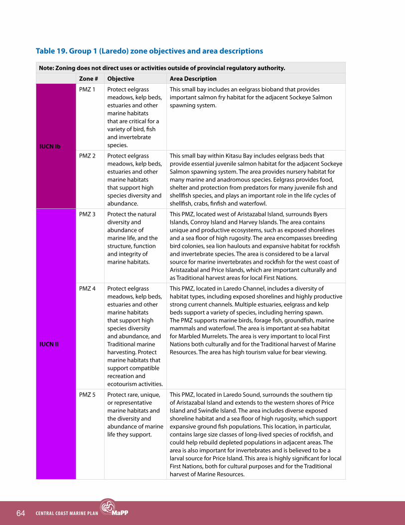
64 CENTRAL COAST MARINE PLAN
Table 19. Group 1 (Laredo) zone objectives and area descriptions
Note: Zoning does not direct uses or activities outside of provincial regulatory authority.
Zone # Objective Area Description
IUCN Ib
PMZ 1 Protect eelgrass meadows, kelp beds, estuaries and other marine habitats that are critical for a variety of bird, fish and invertebrate species.
This small bay includes an eelgrass bioband that provides important salmon fry habitat for the adjacent Sockeye Salmon spawning system.
PMZ 2 Protect eelgrass meadows, kelp beds, estuaries and other marine habitats that support high species diversity and abundance.
This small bay within Kitasu Bay includes eelgrass beds that provide essential juvenile salmon habitat for the adjacent Sockeye Salmon spawning system. The area provides nursery habitat for many marine and anadromous species. Eelgrass provides food, shelter and protection from predators for many juvenile fish and shellfish species, and plays an important role in the life cycles of shellfish, crabs, finfish and waterfowl.
IUCN II
PMZ 3 Protect the natural diversity and abundance of marine life, and the structure, function and integrity of marine habitats.
This PMZ, located west of Aristazabal Island, surrounds Byers Islands, Conroy Island and Harvey Islands. The area contains unique and productive ecosystems, such as exposed shorelines and a sea floor of high rugosity. The area encompasses breeding bird colonies, sea lion haulouts and expansive habitat for rockfish and invertebrate species. The area is considered to be a larval source for marine invertebrates and rockfish for the west coast of Aristazabal and Price Islands, which are important culturally and as Traditional harvest areas for local First Nations.
PMZ 4 Protect eelgrass meadows, kelp beds, estuaries and other marine habitats that support high species diversity and abundance, and Traditional marine harvesting. Protect marine habitats that support compatible recreation and ecotourism activities.
This PMZ, located in Laredo Channel, includes a diversity of habitat types, including exposed shorelines and highly productive strong current channels. Multiple estuaries, eelgrass and kelp beds support a variety of species, including herring spawn. The PMZ supports marine birds, forage fish, groundfish, marine mammals and waterfowl. The area is important at-sea habitat for Marbled Murrelets. The area is very important to local First Nations both culturally and for the Traditional harvest of Marine Resources. The area has high tourism value for bear viewing.
PMZ 5 Protect rare, unique, or representative marine habitats and the diversity and abundance of marine life they support.
This PMZ, located in Laredo Sound, surrounds the southern tip of Aristazabal Island and extends to the western shores of Price Island and Swindle Island. The area includes diverse exposed shoreline habitat and a sea floor of high rugosity, which support expansive ground fish populations. This location, in particular, contains large size classes of long-lived species of rockfish, and could help rebuild depleted populations in adjacent areas. The area is also important for invertebrates and is believed to be a larval source for Price Island. This area is highly significant for local First Nations, both for cultural purposes and for the Traditional harvest of Marine Resources.

65ChAPTER 6: MARINE SPATIAL PLAN
Note: Zoning does not direct uses or activities outside of provincial regulatory authority.
Zone # Objective Area Description
IUCN IV
PMZ 6 Protect areas of high marine habitat and/or species diversity.
Kitasu Bay, a complex habitat, supports a wide diversity of species, including marine birds, mammals, plants, salmon, shellfish, groundfish and forage fish. It is also an important spawning area for herring. The bay holds significant cultural and Traditional harvest values for local First Nations. There is potential concern with all marine habitats and associated species.
PMZ 7 Protect eelgrass meadows, kelp beds, estuaries and other marine habitats that support high species diversity and abundance, and Traditional marine harvesting.
This area, located within Higgins Lagoon, contains eelgrass, bull kelp and giant kelp forests, which support a wide diversity of species, including birds, forage fish, groundfish, marine mammals, waterfowl, salmon, seabirds and shellfish. This area supports herring spawn and is culturally important to local First Nations. There is potential concern with all marine habitats and associated species.
PMZ 8 Protect marine areas of high habitat and/or species diversity. Restore populations of declining or depleted marine species, and protect the habitats and ecosystem functions upon which they rely.
This PMZ, which extends from Rudolf Bay to Milbanke Sound, follows the western and southern shores of Price Island and encompasses Catala Passage. The area has numerous rocky reefs, which are important for threatened abalone and rockfish species, as well as estuaries, which contain eel grass and bull kelp beds that support herring spawn and various invertebrate species (e.g., prawn, Geoduck, Red Sea Urchin and Sea Cucumber populations). Haulouts provide important resting, breeding and predator avoidance sites for seals. This area is important to local First Nations, both for cultural purposes and for the Traditional harvest of Marine Resources. There is concern with the following habitat and species: benthic habitat, groundfish and salmon populations.
PMZ 9 Protect rare, unique, or representative habitats and the diversity and abundance of marine life they support.
This PMZ, located off of Laredo Channel, is a brackish lagoon that supports Sockeye, Chum, Pink and Coho salmon. The mouth of the inlet contains important habitat for abalone and Red Sea Urchin. The area has high tourism value particularly for bear viewing. The area is important to local First Nations, both culturally and for the Traditional harvest of Marine Resources. There is concern with salmon populations and their spawning and rearing habitats.
PMZ 10 Protect ecologically, socially and culturally significant species and their habitats.
This PMZ is located in Kwakwa and includes eelgrass beds that provide essential juvenile salmon habitat for the adjacent Sockeye Salmon spawning system. Coho, Pink and Chum salmon also spawn in this system. The area provides habitat for a wide variety of species including sea cucumber, prawns and herring. The bay holds significant cultural and Traditional harvest values for local First Nations. There is potential concern with all marine habitats and associated species.
Recreation and Tourism SMZ
SMZ 1 Encourage the development of low-impact tourism opportunities that will support local employment and economic security.
This area, located at the top end of Laredo Channel, provides excellent opportunities for whale watching, nature viewing, sport fishing and kayaking.

66 CENTRAL COAST MARINE PLAN
Table 20. Group 1 (Laredo) Recommended Uses and Activities Table
Key:
A Uses and activities are considered to be ‘acceptable’ subject to applicable laws, policy and relevant agreements. Acceptability of any use/activities does not guarantee that a use/activity will be approved.
C Uses and activities are considered to be ‘conditionally acceptable’ subject to applicable laws, policy and relevant agreements, and provided they are consistent with (adhere to) the plan conditions. Conditional acceptability of any use/activities does not guarantee that a use/activity will be approved.
N Uses and activities are considered to be ‘not acceptable’ and should not be approved.
The aboriginal and treaty rights of the Heiltsuk, Kitasoo/Xai’Xais, Nuxalk and Wuikinuxv Nations, to manage and harvest fish and other Marine Resources (i.e., marine plants and animals), as recognized and affirmed under section 35(1) of the Constitution Act, 1982, and developed in the common law, continue and are not restricted by this Plan.
Note: The Plan does not, in any way, alter or limit the exercise of aboriginal title and rights of each of the Central Coast Nations or alter the Province of British Columbia and First Nations consultation obligations specified in agreements or the common law.
Site Name
Gen
eral
M
anag
emen
t Zon
ePM
Z- 1
, 2
PMZ-
3
PMZ-
4, 5
PMZ
- 6
PMZ
- 7
PMZ
- 8
PMZ
- 9
PMZ
- 10
Recr
eatio
n an
d To
urism
SM
Z - 1
Nor
th C
oast
PM
ZN
orth
Coa
st P
MZ
Zone Type
Category Marine Uses and Activities
Bottom Culture Aquaculture Siting – Plants, Shellfish, Other Invertebrates
A N N N C6 C6 N C6 N C13 N C20
Off-Bottom Aquaculture Siting – Plants, Shellfish, Other Invertebrates
A N N N C6 C6 N C6 N C13 N C20
Off-Bottom Aquaculture Siting – Finfish C1 N N N N N N N N N N N
Energy Renewable Energy Generation A N N N C6 N N C6 N C13 N C20
Forestry Operations -- Log Handling and Storage
A N N N C6 C6 C6 C6 C6 C12 N C20
Forestry Operations -- Helicopter Log Drop Sites
A N N C6 A A A A A C12 N AMining Operations N N N N N N N N N N N NCommercial and Recreational Anchorages*
A N C3 C3 C3 C3 C3 C3 C3 A C20 AFloat Homes C2 N N N N N N N N N N NFloating Lodges A N N N C6 C6 C6 C6 C6 C13 N A
Level 1 Docks, Wharves and Facilities A C6,9 C6 C6 C6 C6 C6 C6 C6 C13 C20 A
Level 2 Docks, Wharves and Facilities A N N N N N N N N C13 N N
Commercial Recreation and Tourism A C6,8 C8 C8 A A A A A A C20 A
Public Recreation and Tourism A C6,8 C8 C8 A A A A A A C20 AResearch Research A C4 C5 C5 A A A A A A C20 A
Linear Utilities A C6 C6 C6 C6 N N C6 N C14 C20 C20
Point Source Utilities A N N N N N N N N C14 N N
PMZRec
Tourism SMZ
NC PMZ NC PMZ
Where a use/activity is outside provincial regulatory authority, the approval of that use/activity is subject to the decision-making process(es) of the responsible authorities. Absence does not imply that the use/activity was not considered or evaluated or is of no interest. The reader should contact the appropriate management authority(ies) for direction on uses/activities in such circumstances. Zoning does not direct uses or activities outside of provincial regulatory authority.
*Anchorage restrictions do not apply to commercial towboat reserves and provincially designated boat havens, nor do they apply to vessels in distress or other emergency situations.
Aquaculture
Industry
Infrastructure
Recreation and Tourism
Utilities
GMZ PMZ PMZ PMZ PMZ PMZ PMZ PMZ

67ChAPTER 6: MARINE SPATIAL PLAN
Table 21. Group 1 (Laredo) conditional statements1
C1: Address the interests of the First Nation(s) in whose territory the application is proposed and ensure that the site location is outside the provincial moratorium on marine finfish aquaculture tenures in tidal waters north of Aristazabal Island.
C2: Float homes are conditional on compliance with the provincial government Floating Home Community Policy.
C3: Disturbance of sensitive or critical features and habitat should be avoided; site limitations will be identified in an approved Protection Management Plan.
C4: Only research activities that are non extractive and will not disturb sensitive or critical features and habitats are acceptable.
C5: Only research activities that will not disturb sensitive or critical features and habitats are acceptable.
C6: Should be compatible with conservation objectives of the Protection Management Zone; site limitations will be identified in an approved Protection Management Plan.
C8: Cultural sites may require particular conditions; site limitations will be identified in an approved Protection Management Plan.
C9: Infrastructure is required for service provision of the Protection Management Zone.
C12: New log handling tenures are conditional on their impact on commercial and public recreational experiences, including visual impacts from marine operations.
C13: Any major deterioration of commercial and public recreational experiences, including visual impacts from marine operations, should be limited.
C14: Only utilities that are used for local recreation and tourism development are acceptable.
C17: Recreational anchorage is allowable. The only commercial anchorage allowed is anchorage associated with commercial tourism.
C20: For information on conditions applicable to North Coast areas, see the North Coast Marine Plan.
Additional considerations:
PMZ 1, 2 (IUCN Ib): Ecological and species values might be impacted by commercial fisheries, recreational fishing activity, transportation and temporary port vessel anchorage.
PMZ 3, 4, 5 (IUCN II): Ecological and species values might be impacted by commercial fisheries, recreational fishing activity, transportation and temporary port vessel anchorage.
PMZ 6 (IUCN IV): Ecological and species values might be impacted by commercial fisheries, recreational fishing activity and temporary port vessel anchorage. Commercial value for salmon exists and this activity would not impact the protection objective(s) for the area.
PMZ 7, 9, 10 (IUCN IV): Ecological and species values might be impacted by commercial fisheries, recreational fishing activity and temporary port vessel anchorage.
PMZ 8 (IUCN IV): Ecological and species values and sensitive benthic habitat might be impacted by commercial fisheries, recreational fishing activity and temporary port vessel anchorage.
1 Many conditional statements refer to Protection Management Plans that will be developed in the future. Until Protection Management Plans are developed, conditional activities should meet existing legislation and policy and consider local cultural and ecological values. Protection Management Plans may outline additional requirements.

68 CENTRAL COAST MARINE PLAN
Spatial Planning Group 2 (Finlayson)
figure 10. Spatial Planning group 2 (finlayson)
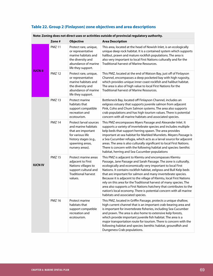
69ChAPTER 6: MARINE SPATIAL PLAN
Table 22. Group 2 (Finlayson) zone objectives and area descriptions
Note: Zoning does not direct uses or activities outside of provincial regulatory authority.
Zone # Objective Area Description
IUCN II
PMZ 11 Protect rare, unique, or representative marine habitats and the diversity and abundance of marine life they support.
This area, located at the head of Nowish Inlet, is an ecologically unique deep rock habitat. It is a contained system which supports halibut, prawn and mature rockfish populations. The area is also very important to local First Nations culturally and for the Traditional harvest of Marine Resources.
PMZ 12 Protect rare, unique, or representative marine habitats and the diversity and abundance of marine life they support.
This PMZ, located at the end of Watson Bay, just off of Finlayson Channel, encompasses a deep pocketed bay with high rugosity, which provides unique inner coast rockfish and halibut habitat. The area is also of high value to local First Nations for the Traditional harvest of Marine Resources.
IUCN IV
PMZ 13 Protect marine habitats that support compatible recreation and ecotourism.
Bottleneck Bay, located off Finlayson Channel, includes an eelgrass estuary that supports juvenile salmon from adjacent Pink, Coho and Chum Salmon systems. The area also supports crab populations and has high tourism values. There is potential concern with all marine habitats and associated species.
PMZ 14 Protect larval sources and marine habitats that are important for various life history stages (e.g., spawning areas, nursery areas).
This PMZ encompasses Myers Passage and Alexander Inlet. It supports a variety of invertebrate species and includes multiple kelp beds that support herring spawn. The area provides important at-sea habitat for Marbled Murrelets. Meyers Passage is a Sea Cucumber refugia, which acts as a larval source for adjacent areas. The area is also culturally significant to local First Nations. There is concern with the following habitat and species: benthic habitat, herring and Sea Cucumber populations
PMZ 15 Protect marine areas adjacent to First Nations villages to support cultural and Traditional harvest values.
This PMZ is adjacent to Klemtu and encompasses Klemtu Passage, Jane Passage and Sarah Passage. The zone is culturally, ecologically and economically very important to local First Nations. It contains rockfish habitat, eelgrass and Bull Kelp beds that are important for salmon and many invertebrate species. Because it is adjacent to the village of Klemtu, local First Nations rely on this area for the Traditional harvest of many species. The area also supports a First Nations hatchery that contributes to the nation’s local economy. There is potential concern with all marine habitats and associated species.
PMZ 16 Protect marine habitats that support compatible recreation and ecotourism.
This PMZ, located in Griffin Passage, protects a unique shallow, high current channel that is an important crab-bearing area and is important for invertebrate fisheries, including Sea Cucumber and prawn. The area is also home to extensive kelp forests, which provide important juvenile fish habitat. The area is a major transportation route for tourism. There is concern with the following habitat and species: benthic habitat, groundfish and Dungeness Crab populations.

70 CENTRAL COAST MARINE PLAN
Note: Zoning does not direct uses or activities outside of provincial regulatory authority.
Zone # Objective Area Description
IUCN IV
PMZ 17 Protect eelgrass meadows, kelp beds, estuaries and other marine habitats that support high species diversity and abundance, and Traditional marine harvesting. Protect marine habitat that is critical to the recovery of threatened or endangered species.
This area, located in the southern half of Finlayson Channel, includes eelgrass meadows and kelp beds. The area supports groundfish and several important invertebrate species, including prawn, Red Sea Urchin and Geoduck. There is an active abalone restoration project in the area; Northern Abalone is listed as an endangered species under the federal Species at Risk Act. The area is also an important mixed-stocked holding area for salmon, and it attracts Humpback Whales, which spend a significant amount of time here during the summer. For local First Nations, this area is very significant culturally, and it supports the Traditional harvest of a variety of important Marine Resources. There is potential concern with all marine habitats and associated species.
PMZ 18 Protect marine areas of high habitat and/or species diversity. Protect marine habitat that is critical to the recovery of threatened or endangered species.
This is a nutrient-rich area of high current, located in the western portion of Oscar Passage. The area supports groundfish and several invertebrate species, including prawn and Sea Cucumbers. Northern Abalone, which is listed as an endangered species under the federal Species at Risk Act, also occurs in the area. For local First Nations, this is a very significant area culturally, and it supports the Traditional harvest of a variety of important Marine Resources. There is potential concern with all marine habitats and associated species.
PMZ 19 Protect rare, unique, or representative marine habitats and the diversity and abundance of marine life they support.
This PMZ, located in Jackson Pass, is in a unique high tidal area. It supports dense populations of clams and Box Crabs, and has high prawn and Sea Cucumber value. It is within a DFO-designated refugia for Sea Cucumber. There is concern with the following habitat and species: benthic habitat, groundfish, salmon, shellfish (with the exception of prawn) and pelagic populations.
Aqua-culture SMZ
SMZ 2 Encourage the development of shellfish aquaculture that will support local employment and economic security.
This area is located in Finlayson Channel between the north end of Cone Island and Wallace Bight. Provincial studies initially identified segments of this area as being suitable for shellfish aquaculture (scallops and oysters); this was further confirmed by site work conducted by First Nations.

71ChAPTER 6: MARINE SPATIAL PLAN
Table 23. Group 2 (Finlayson) Recommended Uses and Activities Table
Key:
A Uses and activities are considered to be ‘acceptable’ subject to applicable laws, policy and relevant agreements. Acceptability of any use/activities does not guarantee that a use/activity will be approved.
C Uses and activities are considered to be ‘conditionally acceptable’ subject to applicable laws, policy and relevant agreements, and provided they are consistent with (adhere to) the plan conditions. Conditional acceptability of any use/activities does not guarantee that a use/activity will be approved.
N Uses and activities are considered to be ‘not acceptable’ and should not be approved.
The aboriginal and treaty rights of the Heiltsuk, Kitasoo/Xai’Xais, Nuxalk and Wuikinuxv Nations, to manage and harvest fish and other Marine Resources (i.e., marine plants and animals), as recognized and affirmed under section 35(1) of the Constitution Act, 1982, and developed in the common law, continue and are not restricted by this Plan.
Note: The Plan does not, in any way, alter or limit the exercise of aboriginal title and rights of each of the Central Coast Nations or alter the Province of British Columbia and First Nations consultation obligations specified in agreements or the common law.
Site Name
General
Managem
ent Zon
ePM
Z‐ 11, 12
PMZ ‐ 13
PMZ ‐ 14
PMZ‐ 15
PMZ ‐ 16
PMZ ‐ 17
PMZ ‐ 18
PMZ ‐ 19
SMZ ‐ 2
PMZ PMZPMZ PMZGMZ Aquaculture SMZPMZ PMZ PMZPMZ
Zone TypeCategory Marine Uses and Activities
Bottom Culture Aquaculture Siting – Plants, Shellfish, Other Invertebrates A N N N C6 C6 N C6 C1, 18 A
Off‐Bottom Aquaculture Siting – Plants, Shellfish, Other Invertebrates A N N N C6 C6 N C6 C1, 18 A
Off‐Bottom Aquaculture Siting – Finfish C1 N N C1 C1 C1 N C1 C1, 18 C1
Energy Renewable Energy Generation A N N N C6 C6 N C6 N C15
Forestry Operations – Log Handling and Storage A N C6, 12 C6 C6 C6 C6 C6 C6 C10
Forestry Operations – Helicopter Log Drop Sites A C6 A A A A A A A C10
Mining Operations N N N N N N N N N NCommercial and Recreational Anchorages* A C3 C3 C3 C3 C3 C3 C3 C3 A
Float Homes C2 N N N N N N N N NFloating Lodges A N N N C6 C6 N C6 N NLevel 1 Docks, Wharves and Facilities A C6 C6 A C6 C6 C6 C6 A C15
Level 2 Docks, Wharves and Facilities A N N N C6 N N N N NCommercial Recreation and Tourism A C8 A A A A C8 A A APublic Recreation and Tourism A C8 A A A A C8 A A A
Research Research A C5 A A A A C5 A A ALinear Utilities A C6 C6 A C6 C6 C6 C6 A APoint Source Utilities A N N N N N N N N N
PMZ
Utilities
Aquaculture
Industry
Infrastructure
Recreation and Tourism
Where a use/activity is outside provincial regulatory authority, the approval of that use/activity is subject to the decision‐making process(es) of the responsible authorities. Absence does not imply that the use/activity was not considered or evaluated or is of no interest. The reader should contact the appropriate management authority(ies) for direction on uses/activities in such circumstances. Zoning does not direct uses or activities outside of provincial regulatory authority.
PMZPMZ
*Anchorage restrictions do not apply to commercial towboat reserves and provincially designated boat havens, nor do they apply to vessels in distress or other emergency situations.
PMZGMZ
Aquaculture SMZPMZ PMZ PMZPMZ

72 CENTRAL COAST MARINE PLAN
Table 24. Group 2 (Finlayson) conditional statements1
C1: Address the interests of the First Nation(s) in whose territory the application is proposed, ensuring that the site location is outside the provincial moratorium on marine finfish aquaculture tenures in tidal waters north of Aristazabal Island.
C2: Float homes are conditional on compliance with the provincial government Floating Home Community Policy.
C3: Disturbance of sensitive or critical features and habitat should be avoided; site limitations will be identified in an approved Protection Management Plan.
C5: Only research activities that will not disturb sensitive or critical features and habitats are acceptable.
C6: Should be compatible with conservation objectives of the Protection Management Zone; site limitations will be identified in an approved Protection Management Plan.
C8: Cultural sites may require particular conditions; site limitations will be identified in an approved Protection Management Plan.
C10: New log handling tenures are conditional on their impact on existing and future aquaculture operations. Optimal sites will be identified through detailed planning for Aquaculture SMZs.
C12: New log handling tenures are conditional on their impact on commercial and public recreational experiences, including visual impacts from marine operations.
C15: Only infrastructure that is used for aquaculture is acceptable.
C18: Aquaculture operations are considered to be acceptable only if they take place outside Jackson Narrows Marine Park and Rescue Bay.
Additional Considerations:
PMZ 11, 12 (IUCN II): Ecological and species values might be impacted by commercial fisheries, recreational fishing activity, transportation and temporary port vessel anchorage.
PMZ 14 (IUCN IV): Ecological and species values and sensitive benthic habitat might be impacted by commercial fisheries and temporary port vessel anchorage. Recreational fishing values exist and these activities would not impact the protection objectives of the area.
PMZ 13, 15, 16, 17, 18 (IUCN IV): Ecological and species values might be impacted by commercial fisheries, recreational fishing activity and temporary port vessel anchorage.
PMZ 19 (IUCN IV): Ecological and species values and sensitive benthic habitat might be impacted by commercial fisheries, recreational fishing activity and temporary port vessel anchorage. Commercial and recreational value for prawns exists and these activities would not impact the protection objective(s) for the area.
1 Many conditional statements refer to Protection Management Plans that will be developed in the future. Until Protection Management Plans are developed, conditional activities should meet existing legislation and policy and consider local cultural and ecological values. Protection Management Plans may outline additional requirements.

73ChAPTER 6: MARINE SPATIAL PLAN
Spatial Planning Group 3 (Tolmie)
figure 11. Spatial Planning group 3 (Tolmie)

74 CENTRAL COAST MARINE PLAN
Table 25. Group 3 (Tolmie) zone objectives and area descriptions
Note: Zoning does not direct uses or activities outside of provincial regulatory authority.
Zone # Objective Area Description
IUCN II
PMZ 20 Protect eelgrass meadows, kelp beds, estuaries and other marine habitats that support high species diversity and abundance, and Traditional marine harvesting.
This estuary, located at the end of Laredo inlet, and the surrounding area provide eelgrass habitat that supports Dungeness Crab and prawn populations. The head of the inlet is a known larval source for both of these species and supports populations in the rest of Laredo Inlet. It has high Traditional harvest value for local First Nations.
PMZ 21 Protect marine areas of high habitat and/or species diversity.
This area encompasses Khutze Inlet and Griffin Point. The Tolmie Channel portion is an area with high currents and high biodiversity. Khutze Inlet includes estuarine habitats, eelgrass and Bull Kelp beds that support waterfowl/waterbird species at risk, prawn and Sea Cucumber populations. All five species of salmon, and herring spawn occur here. The inlet also provides important Marbled Murrelet at-sea habitat and has high tourism value.
PMZ 22 Protect eelgrass meadows, kelp beds, estuaries and other marine habitats that support high species diversity and abundance, and Traditional marine harvesting.
This is an area of high productivity that encompasses complex marine habitats and ecological processes, including multiple estuaries, eelgrass habitats and areas of high mixing and rapid currents. The area is important for Dungeness Crab, cockles, multiple rockfish and groundfish species, marine mammals, including seal haulouts, marine birds, multiple salmon life stages, waterfowl and forage fish. The inlets provide a good larval source for marine invertebrates and groundfish, which are locally abundant. The area has significant cultural and Traditional harvest value for local First Nations and has high tourism value.
PMZ 23 Protect eelgrass meadows, kelp beds, estuaries and other marine habitats that support high species diversity and abundance.
A small bay off of Finlayson Channel, Carter Bay, is an important estuary that provides bull kelp habitat and a staging area for an adjacent Sockeye salmon run. The bay also has high value for commercial tourism, with a kayak campsite and anchorage.

75ChAPTER 6: MARINE SPATIAL PLAN
Note: Zoning does not direct uses or activities outside of provincial regulatory authority.
Zone # Objective Area Description
IUCN IV
PMZ 24 Protect eelgrass meadows, kelp beds, estuaries and other marine habitats that support high species diversity and abundance.
This PMZ encompasses Green Lagoon and part of Tolmie Channel. High currents and upwelling make this PMZ ecologically productive and important for many species, and it is an important forage area for seabirds. The area also provides important Marbled Murrelet at-sea habitat. Green Lagoon is a large estuary and is important for multiple species. The area is a known Sea Cucumber larval source for adjacent areas. The PMZ is an important area to local First Nations for the Traditional harvest of Marine Resources and has high tourism value. There is potential concern with all marine habitats and associated species.
PMZ 25 Protect rare, unique or representative marine habitats and the diversity and abundance of marine life they support.
This deep fjord includes areas of eelgrass, seaweed and forage fish habitat. It supports healthy populations of invertebrate species such as Sea Cucumber and prawn, as well as dogfish, which could support productive commercial fisheries. The fjord is an important cultural and Traditional harvest area for local First Nations, but it has been impacted by the overharvest of rockfish. There is concern with benthic habitat and groundfish populations.
PMZ 26 Protect eelgrass meadows, kelp beds, estuaries and other marine habitats that support high species diversity and abundance.
Bolin Bay is located just off of Sheep Passage. This estuary includes eelgrass habitat that supports crab populations and provides important salmon habitat for various life stages. The estuary is frequented by Spirit Bears. The bay is an important cultural and Traditional harvest area for local First Nations. The PMZ is significant to the local tourism industry, due to the prevalence of Spirit Bears and the pristine nature of the area. There is potential concern with all marine habitats and associated species.
Aqua-culture SMZ
SMZ 3 Encourage the development of finfish aquaculture that will support local employment and economic security.
This area is located in Sheep Passage. Provincial studies initially identified segments of this area as being suitable for finfish aquaculture (salmon); this was further confirmed by site work and active farming conducted by First Nations. This zone overlaps an Important Bird Area identified by Bird Studies Canada and Nature Canada, which should be taken into consideration.

76 CENTRAL COAST MARINE PLAN
Table 26. Group 3 (Tolmie) Recommended Uses and Activities Table
Key:
A Uses and activities are considered to be ‘acceptable’ subject to applicable laws, policy and relevant agreements. Acceptability of any use/activities does not guarantee that a use/activity will be approved.
C Uses and activities are considered to be ‘conditionally acceptable’ subject to applicable laws, policy and relevant agreements, and provided they are consistent with (adhere to) the plan conditions. Conditional acceptability of any use/activities does not guarantee that a use/activity will be approved.
N Uses and activities are considered to be ‘not acceptable’ and should not be approved.
The aboriginal and treaty rights of the Heiltsuk, Kitasoo/Xai’Xais, Nuxalk and Wuikinuxv Nations, to manage and harvest fish and other Marine Resources (i.e., marine plants and animals), as recognized and affirmed under section 35(1) of the Constitution Act, 1982, and developed in the common law, continue and are not restricted by this Plan.
Note: The Plan does not, in any way, alter or limit the exercise of aboriginal title and rights of each of the Central Coast Nations or alter the Province of British Columbia and First Nations consultation obligations specified in agreements or the common law.
Site Name
General
Managem
ent Zon
e
PMZ‐ 20, 21, 22, 23
PMZ ‐ 24
PMZ‐ 25
PMZ ‐ 26
SMZ ‐ 3
PMZAquaculture
SMZPMZGMZ PMZPMZZone Type
Category Marine Uses and Activities
Bottom Culture Aquaculture Siting – Plants, Shellfish, Other Invertebrates
A N N C6 N A
Off‐Bottom Aquaculture Siting – Plants, Shellfish, Other Invertebrates
A N N C6 N A
Off‐Bottom Aquaculture Siting – Finfish C1 N N C1 N C1
Energy Renewable Energy Generation A N N C6 C6 C15
Forestry Operations – Log Handling and Storage A N C6 C6 C6 C10
Forestry Operations – Helicopter Log Drop Sites A C6 A A A C10
Mining Operations N N N N N NCommercial and Recreational Anchorages* A C3 C3 C3 C3 A
Float Homes C2 N N N N NFloating Lodges A N N C6 C6 NLevel 1 Docks, Wharves and Facilities A C6 C6 C6 C6 C15
Level 2 Docks, Wharves and Facilities A N N N N NCommercial Recreation and Tourism A C8 C8 A A A
Public Recreation and Tourism A C8 C8 A A A
Research Research A C5 C5 A A ALinear Utilities A C6 C6 C6 C6 APoint Source Utilities A N N N N N
PMZ
Utilities
Where a use/activity is outside provincial regulatory authority, the approval of that use/activity is subject to the decision‐making process(es) of the responsible authorities. Absence does not imply that the use/activity was not considered or evaluated or is of no interest. The reader should contact the appropriate management authority(ies) for direction on uses/activities in such circumstances. Zoning does not direct uses or activities outside of provincial regulatory authority.*Anchorage restrictions do not apply to commercial towboat reserves and provincially designated boat havens, nor do they apply to vessels in distress or other emergency situations.
Aquaculture SMZ
Aquaculture
Industry
Infrastructure
Recreation and Tourism
PMZGMZ PMZPMZ

77ChAPTER 6: MARINE SPATIAL PLAN
Table 27. Group 3 (Tolmie) conditional statements1
C1: Address the interests of the First Nation(s) in whose territory the application is proposed, ensuring that the site location is outside the provincial moratorium on marine finfish aquaculture tenures in tidal waters north of Aristazabal Island.
C2: Float homes are conditional on compliance with the provincial government Floating Home Community Policy.
C3: Disturbance of sensitive or critical features and habitat should be avoided; site limitations will be identified in an approved Protection Management Plan.
C5: Only research activities that will not disturb sensitive or critical features and habitats are acceptable.
C6: Should be compatible with conservation objectives of the Protection Management Zone; site limitations will be identified in an approved Protection Management Plan.
C8: Cultural sites may require particular conditions; site limitations will be identified in an approved Protection Management Plan.
C10: New log handling tenures are conditional on their impact on existing and future aquaculture operations. Optimal sites will be identified through detailed planning for Aquaculture SMZs.
C15: Only infrastructure that is used for aquaculture is acceptable.
Additional Considerations:
PMZ 20, 21, 22, 23 (IUCN II): Ecological and species values might be impacted by commercial fisheries, recreational fishing activity, transportation and temporary port vessel anchorage.
PMZ 24, 25, 26 (IUCN IV): Ecological and species values and sensitive benthic habitat might be impacted by commercial fisheries, recreational fishing activity and temporary port vessel anchorage.
1 Many conditional statements refer to Protection Management Plans that will be developed in the future. Until Protection Management Plans are developed, conditional activities should meet existing legislation and policy and consider local cultural and ecological values. Protection Management Plans may outline additional requirements.
Photo by Charles Short

78 CENTRAL COAST MARINE PLAN
Spatial Planning Group 4 (Milbanke)
figure 12. Spatial Planning group 4 (Milbanke)

79ChAPTER 6: MARINE SPATIAL PLAN
Table 28. Group 4 (Milbanke) zone objectives and area descriptions
Note: Zoning does not direct uses or activities outside of provincial regulatory authority.
Zone # Objective Area Description
IUCN Ib
PMZ 27 Protect eelgrass meadows, kelp beds, estuaries and other marine habitats that support high species diversity and abundance.
This small bay includes eelgrass beds that provide essential juvenile salmon habitat for the adjacent Sockeye Salmon spawning system. Eelgrass beds provide a nursery area for many marine and anadromous species. The area provides food, shelter and protection from predators for many juvenile fish and shellfish species, and plays an important role in the life cycles of shellfish, crabs, finfish and waterfowl.
IUCN II
PMZ 28 Protect populations of commercially important marine species and their habitats, including spawning areas, nursery areas and other habitat for important life history stages.
This PMZ, located in Queen Charlotte Sound, contains important halibut rearing grounds and supports abundant crab stocks. It is an important area for local First Nations for the Traditional harvest of Marine Resources.
IUCN IV
PMZ 29 Restore populations of declining or depleted marine species, and protect the habitats and ecosystem functions upon which they rely.
This PMZ follows a submarine bank and exposed shoreline/rocky reef habitat that support a high abundance of rockfish species. This location, in particular, contains large size classes of long-lived species of rockfish, and could help rebuild depleted populations in adjacent areas. The area also contains eelgrass and kelp beds that support herring spawn, and it provides haulouts for sea lions. Several marine bird species are found here. The area is important to local First Nations for the Traditional harvest of marine species. There is concern with benthic habitat and groundfish populations.
PMZ 30 Restore populations of declining or depleted marine species, and protect the habitats and ecosystem functions upon which they rely.
This PMZ follows a submarine bank and exposed shoreline/rocky reef habitat that support a high abundance of rockfish species. The area also contains eelgrass and kelp beds that support herring spawn, and it provides haulouts for sea lions. Several marine bird species are found here. The area is important to local First Nations for the Traditional harvest of marine species. There is concern with benthic habitat and groundfish populations.
PMZ 31 Protect eelgrass meadows, kelp beds, estuaries and other marine habitats that support high species diversity and abundance.
This PMZ, located in Raymond Passage, includes Bull Kelp and Giant Kelp forests, and eelgrass that supports herring spawn. The area provides habitat for a wide variety of species, including rockfish, groundfish, salmon, Dungeness Crab and clams. It is important to local First Nations both culturally and for the Traditional harvest of multiple species. There is concern with the following habitat and species: benthic habitat, groundfish, salmon, shellfish, and pelagic populations.

80 CENTRAL COAST MARINE PLAN
Note: Zoning does not direct uses or activities outside of provincial regulatory authority.
Zone # Objective Area Description
IUCN IV
PMZ 32 Protect ecologically, socially and culturally significant marine species and their habitats, and facilitate Traditional use by local First Nations.
This area, located in Thompson Bay, includes eelgrass and kelp beds that support marine birds, herring spawn and a number of invertebrate species. The area supports rockfish populations and is important to local First Nations for the Traditional harvest of Marine Resources. There is concern with benthic habitat and groundfish populations.
PMZ 33 Protect marine habitats adjacent to First Nations villages to support cultural and Traditional harvest values.
This area, located on the eastern and southern sides of Goose Island, has high rugosity and includes eelgrass and kelp beds that support marine birds, herring spawn and a number of invertebrate species. The area also provides important Marbled Murrelet at-sea habitat and is important to local First Nations for the Traditional harvest of Marine Resources. There is concern with benthic habitat and groundfish populations.
Aqua-culture SMZ
SMZ 4 Encourage the development of shellfish aquaculture that will support local employment and economic security.
This area, located in the McMullin Group, is a series of islands and rocky reefs with considerable currents, nutrient exchange and suitable substrate for shellfish aquaculture. Provincial studies initially identified this area as being suitable for shellfish aquaculture (scallops and oysters); this was further confirmed by site work conducted by First Nations. The area also has minimal overlap with commercial shellfish fisheries.
SMZ 5 Encourage the development of shellfish aquaculture that will support local employment and economic security.
This area, located around Blair Inlet, is a series of islets with a mix of open channels and protected bays that have good tidal flow and good substrate for shellfish production. Provincial studies initially identified segments of this area as being suitable for shellfish aquaculture (scallops and oysters); this was further confirmed through site work conducted by First Nations.
Photo by Charles Short

81ChAPTER 6: MARINE SPATIAL PLAN
Table 29. Group 4 (Milbanke) Recommended Uses and Activities Table
Key:
A Uses and activities are considered to be ‘acceptable’ subject to applicable laws, policy and relevant agreements. Acceptability of any use/activities does not guarantee that a use/activity will be approved.
C Uses and activities are considered to be ‘conditionally acceptable’ subject to applicable laws, policy and relevant agreements, and provided they are consistent with (adhere to) the plan conditions. Conditional acceptability of any use/activities does not guarantee that a use/activity will be approved.
N Uses and activities are considered to be ‘not acceptable’ and should not be approved.
The aboriginal and treaty rights of the Heiltsuk, Kitasoo/Xai’Xais, Nuxalk and Wuikinuxv Nations, to manage and harvest fish and other Marine Resources (i.e., marine plants and animals), as recognized and affirmed under section 35(1) of the Constitution Act, 1982, and developed in the common law, continue and are not restricted by this Plan.
Note: The Plan does not, in any way, alter or limit the exercise of aboriginal title and rights of each of the Central Coast Nations or alter the Province of British Columbia and First Nations consultation obligations specified in agreements or the common law.
Site Name
General
Managem
ent Zon
ePM
Z‐ 27
PMZ ‐ 28
PMZ ‐ 29
PMZ ‐ 30
PMZ ‐ 31
PMZ ‐ 32
PMZ ‐ 33
SMZ ‐ 4
SMZ ‐ 5
PMZ PMZ PMZPMZ PMZPMZ PMZGMZAquaculture
SMZAquaculture
SMZZone Type
Category Marine Uses and Activities
Bottom Culture Aquaculture Siting – Plants, Shellfish, Other Invertebrates
A N N C6 C6 A A A C7 A
Off‐Bottom Aquaculture Siting – Plants, Shellfish, Other Invertebrates
A N N C6 C6 A A A C7 A
Off‐Bottom Aquaculture Siting – Finfish C1 N N N N N N N C1 C1
Energy Renewable Energy Generation A N N N N C6 N N C15 C15
Forestry Operations – Log Handling and Storage A N N C6 C6 C6 C6 C6 C10 C10
Forestry Operations – Helicopter Log Drop Sites A N C6 A A A A A C10 C10
Mining Operations N N N N N N N N N NCommercial and Recreational Anchorages* A N C3 C3 C3 C3 C3 C3 A A
Float Homes C2 N N N N N N N N NFloating Lodges A N N A A C6 C6 C6 N NLevel 1 Docks, Wharves and Facilities A C6,9 C6,9 C6 C6 C6 C6 C6 C15 C15
Level 2 Docks, Wharves and Facilities A N N N N N N N N NCommercial Recreation and Tourism A C6,8 C8 A A A A A A A
Public Recreation and Tourism A C6,8 C8 A A A A A A AResearch Research A C4 C5 A A A A A A A
Linear Utilities A C6 C6 N N C6 N N A APoint Source Utilities A N N N N N N N N N
Recreation and Tourism
Utilities
Where a use/activity is outside provincial regulatory authority, the approval of that use/activity is subject to the decision‐making process(es) of the responsible authorities. Absence does not imply that the use/activity was not considered or evaluated or is of no interest. The reader should contact the appropriate management authority(ies) for direction on uses/activities in such circumstances. Zoning does not direct uses or activities outside of provincial regulatory authority.*Anchorage restrictions do not apply to commercial towboat reserves and provincially designated boat havens, nor do they apply to vessels in distress or other emergency situations.
Infrastructure
PMZ PMZ PMZPMZ PMZPMZ PMZGMZAquaculture
SMZAquaculture
SMZ
Aquaculture
Industry

82 CENTRAL COAST MARINE PLAN
Table 30. Group 4 (Milbanke) conditional statements1
C1: Address the interests of the First Nation(s) in whose territory the application is proposed, ensuring that the site location is outside the provincial moratorium on marine finfish aquaculture tenures in tidal waters north of Aristazabal Island.
C2: Float homes are conditional on compliance with the provincial government Floating Home Community Policy.
C3: Disturbance of sensitive or critical features and habitat should be avoided; site limitations will be identified in an approved Protection Management Plan.
C4: Only research activities that are non extractive and will not disturb sensitive or critical features and habitats are acceptable.
C5: Only research activities that will not disturb sensitive or critical features and habitats are acceptable.
C6: Should be compatible with conservation objectives of the Protection Management Zone; site limitations will be identified in an approved Protection Management Plan.
C7: Aquaculture operations should consider visual quality and shoreline access for shoreline activities
C8: Cultural sites may require particular conditions; site limitations will be identified in an approved Protection Management Plan.
C9: Infrastructure is required for service provision of the Protection Management Zone.
C10: New log handling tenures are conditional on their impact on existing and future aquaculture operations. Optimal sites will be identified through detailed planning for Aquaculture SMZs.
C15: Only infrastructure that is used for aquaculture is acceptable.
Additional Considerations:
PMZ 27 (IUCN Ib): Ecological and species values might be impacted by commercial fisheries, recreational fishing activity, transportation and temporary port vessel anchorage.
PMZ 28 (IUCN II): Ecological and species value might be impacted by commercial fisheries, recreational fishing activity, transportation and temporary port vessel anchorage.
PMZ 29, 32, 33 (IUCN IV): Ecological and species values and sensitive benthic habitat might be impacted by commercial fisheries, recreational fishing activity and temporary port vessel anchorage.
PMZ 30 (IUCN IV): Ecological and species values and sensitive benthic habitat might be impacted by commercial fisheries and temporary port vessel anchorage. Recreational fishing values exist and these activities would not impact the protection objective(s) for the area.
PMZ 31 (IUCN IV): Ecological and species values and sensitive benthic habitat might be impacted by commercial fisheries, recreational fishing activity and temporary port vessel anchorage. Commercial value for clams, prawn, Sea Cucumber and spawn-on-kelp exist and these activities would not impact the protection objective(s) for the area. Recreational value for clams exist and would not impact the protection objective(s) for the area.
1 Many conditional statements refer to Protection Management Plans that will be developed in the future. Until Protection Management Plans are developed, conditional activities should meet existing legislation and policy and consider local cultural and ecological values. Protection Management Plans may outline additional requirements.

83ChAPTER 6: MARINE SPATIAL PLAN
Spatial Planning Group 5 (Seaforth/Spiller)
figure 13. Spatial Planning group 5 (Seaforth/Spiller)

84 CENTRAL COAST MARINE PLAN
Table 31. Group 5 (Seaforth/Spiller) zone objectives and area descriptions
Note: Zoning does not direct uses or activities outside of provincial regulatory authority.
Zone # Objective Area Description
IUCN Ib
PMZ 34 Protect eelgrass meadows, kelp beds, estuaries and other marine habitats that support high species diversity and abundance.
This small bay includes eelgrass beds that provide essential juvenile salmon habitat for the adjacent Sockeye Salmon spawning system. Eelgrass beds provide a nursery area for many marine and anadromous species. The area provides food, shelter and protection from predators for many juvenile fish and shellfish species, and it plays an important role in the life cycles of shellfish, crabs, finfish and waterfowl.
IUCN II
PMZ 35 Protect ecologically, socially and culturally significant marine species and their habitats to facilitate Traditional use by local First Nations.
This PMZ is located between Cunningham Island, Horsfall Island and Chatfield Island, and extends half way up Return Channel. The area includes a number of estuaries, and supports an important Chum Salmon system, groundfish, clam, crab, seaweed and kelp. It is also culturally important to local First Nations for the Traditional harvest of marine species.
PMZ 36 Protect ecologically, socially and culturally significant marine species and their habitats.
This PMZ is located near the head of Spiller Channel and encompasses part of Ellerslie Bay, Ellerslie Lagoon and Spiller Inlet. This area has important marine habitat for juvenile salmon, crab and bivalves. There is a small Eulachon run near the glacial waterfall in the lagoon. It has high local cultural and education values throughout the zone.
PMZ 37 Protect larval sources and habitats important for various life history stages (e.g., spawning areas, nursery areas) of ecologically, socially and culturally important species and the habitats and ecosystem functions upon which they rely.
Located in Clatse Bay in Roscoe Inlet, this PMZ has unique ecological, cultural, and scenic features. The bay includes eelgrass, important salmon systems, crab habitat and groundfish populations. The area is also an important estuary for many bird species as well as bears. The area includes many sensitive cultural features and has cultural significance for local First Nations.
IUCN IV
PMZ 38 Protect eelgrass meadows, kelp beds, estuaries and other marine habitats that support high species diversity and abundance. Protect marine areas adjacent to First Nations villages to support cultural and Traditional harvest values.
This PMZ encompasses Spiller Channel and Spiller Inlet, and includes estuaries, eelgrass beds and Bull Kelp. The area is important for many species, including Chum Salmon, prawn and Sea Cucumber. It is an important and sensitive herring holding and spawning area. This area provides some Marbled Murrelet marine habitat. Neekas Inlet includes an eelgrass estuary, Dungeness Crab populations, and Chum, Pink, and Coho Salmon spawning grounds. There is concern with the following habitat and species: benthic habitat, groundfish, shellfish (with the exception of clams) and pelagic populations.

85ChAPTER 6: MARINE SPATIAL PLAN
Note: Zoning does not direct uses or activities outside of provincial regulatory authority.
Zone # Objective Area Description
PMZ 39 Protect and restore populations of declining or depleted marine species, and the habitats and ecosystem functions upon which they rely.
This PMZ, located at the top of Briggs Inlet, contains eelgrass and Bull Kelp beds, and supports a small salmon system and large populations of Dungeness Crab and various prawn species. The area provides at-sea habitat for Marbled Murrelets and is culturally important to local First Nations. There is concern with benthic habitat and Dungeness Crab populations.
IUCN IV
PMZ 40 Protect marine areas that support low impact recreation and ecotourism activities. Protect ecologically, socially and culturally important marine species and their habitats to facilitate Traditional use by local First Nations.
This PMZ, located in Roscoe Inlet, has unique scenic features and contains several bear viewing sites. The area contains deep fjord habitat and eelgrass beds, and supports multiple species including crab, halibut, cod, Spring Salmon and substantial prawn populations. The area is important to local First Nations both culturally and for the Traditional harvest of Marine Resources. There is concern with the following habitat and species: benthic habitat, groundfish, shellfish (with the exception of prawn) and pelagic populations.
PMZ 41 Restore populations of declining or depleted marine species, and the habitats and ecosystem functions upon which they rely. Protect ecologically, socially and culturally important marine species and their habitats.
This area encompasses Bullock Channel, and supports groundfish, clam, crab and salmon populations. The area has been heavily impacted by the recreational fishery, and salmon system restoration is under way. The area also provides important Marbled Murrelet at-sea habitat and is important to local First Nations for the Traditional harvest of Marine Resources. There is potential concern with all marine habitats and associated species.
Aqua-culture SMZ
SMZ 6 Encourage the development of shellfish aquaculture that will support local employment and economic security.
This area, located at the head of Spiller Inlet, has potential for closed containment finfish aquaculture and shellfish aquaculture, and potential for adjacent alternative energy generation to support remote aquaculture activities. Provincial studies initially identified this area as being suitable for shellfish aquaculture (scallops and oysters); this was further confirmed by site work conducted by First Nations.
SMZ 7 Encourage the development of shellfish aquaculture that will support local employment and economic security.
This area, located in Briggs Inlet, has high tidal flow. Provincial studies initially identified this area as being suitable for shellfish aquaculture (scallops and oysters); this was further confirmed by site work conducted by First Nations.
SMZ 8 Encourage the development of shellfish aquaculture that will support local employment and economic security.
This bay, located in Morehouse Bay, has a mix of protected and exposed areas. Provincial studies initially identified this area as being suitable for shellfish aquaculture (scallops and oysters); this was further confirmed by site work conducted by First Nations.
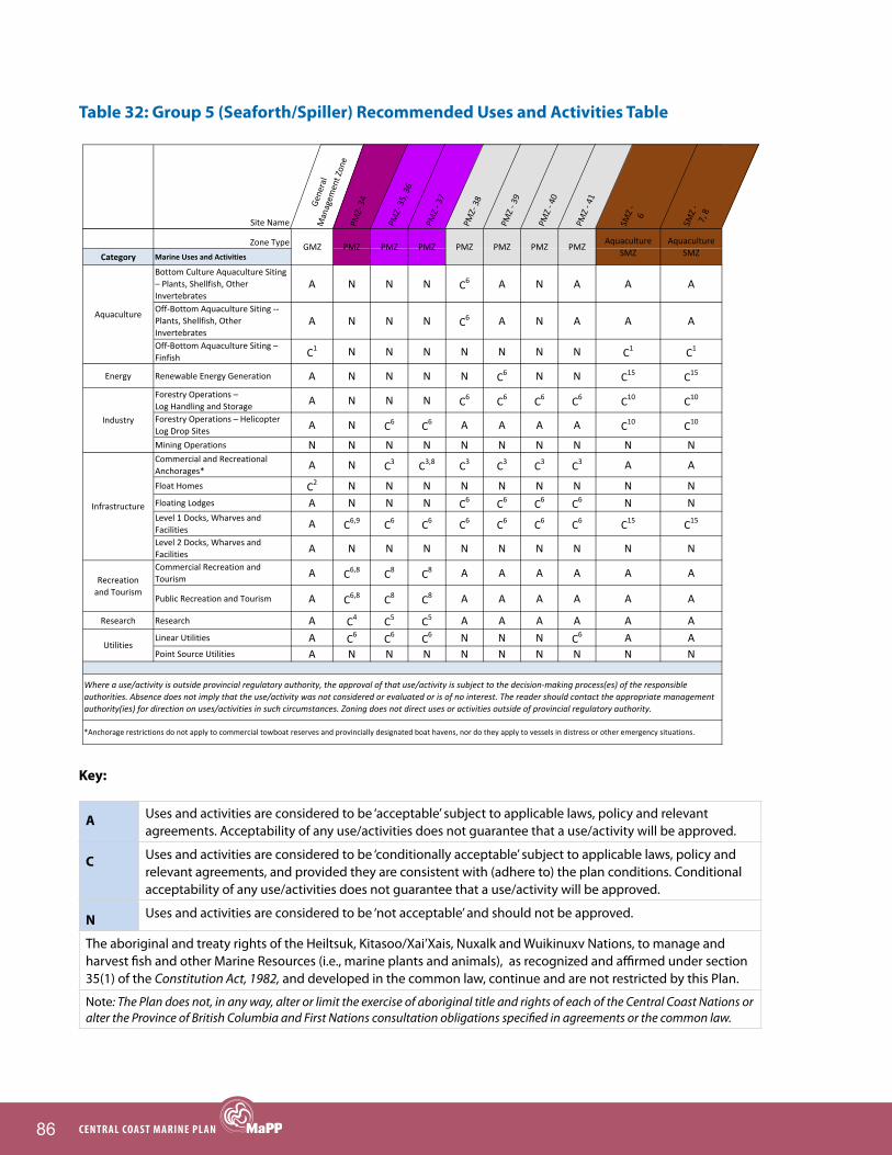
86 CENTRAL COAST MARINE PLAN
Table 32: Group 5 (Seaforth/Spiller) Recommended Uses and Activities Table
Key:
A Uses and activities are considered to be ‘acceptable’ subject to applicable laws, policy and relevant agreements. Acceptability of any use/activities does not guarantee that a use/activity will be approved.
C Uses and activities are considered to be ‘conditionally acceptable’ subject to applicable laws, policy and relevant agreements, and provided they are consistent with (adhere to) the plan conditions. Conditional acceptability of any use/activities does not guarantee that a use/activity will be approved.
N Uses and activities are considered to be ‘not acceptable’ and should not be approved.
The aboriginal and treaty rights of the Heiltsuk, Kitasoo/Xai’Xais, Nuxalk and Wuikinuxv Nations, to manage and harvest fish and other Marine Resources (i.e., marine plants and animals), as recognized and affirmed under section 35(1) of the Constitution Act, 1982, and developed in the common law, continue and are not restricted by this Plan.
Note: The Plan does not, in any way, alter or limit the exercise of aboriginal title and rights of each of the Central Coast Nations or alter the Province of British Columbia and First Nations consultation obligations specified in agreements or the common law.
Site Name
General
Managem
ent Zon
ePM
Z‐ 34
PMZ‐ 35, 36
PMZ ‐ 37
PMZ‐ 38
PMZ ‐ 39
PMZ ‐ 40
PMZ ‐ 41
SMZ ‐ 6
SMZ ‐
7, 8
PMZ PMZAquaculture
SMZPMZ PMZ PMZ PMZGMZ PMZAquaculture
SMZZone Type
Category Marine Uses and Activities
Bottom Culture Aquaculture Siting – Plants, Shellfish, Other Invertebrates
A N N N C6 A N A A A
Off‐Bottom Aquaculture Siting ‐‐ Plants, Shellfish, Other Invertebrates
A N N N C6 A N A A A
Off‐Bottom Aquaculture Siting – Finfish C1 N N N N N N N C1 C1
Energy Renewable Energy Generation A N N N N C6 N N C15 C15
Forestry Operations – Log Handling and Storage A N N N C6 C6 C6 C6 C10 C10
Forestry Operations – Helicopter Log Drop Sites A N C6 C6 A A A A C10 C10
Mining Operations N N N N N N N N N NCommercial and Recreational Anchorages* A N C3 C3,8 C3 C3 C3 C3 A A
Float Homes C2 N N N N N N N N NFloating Lodges A N N N C6 C6 C6 C6 N NLevel 1 Docks, Wharves and Facilities A C6,9 C6 C6 C6 C6 C6 C6 C15 C15
Level 2 Docks, Wharves and Facilities A N N N N N N N N NCommercial Recreation and Tourism A C6,8 C8 C8 A A A A A A
Public Recreation and Tourism A C6,8 C8 C8 A A A A A A
Research Research A C4 C5 C5 A A A A A ALinear Utilities A C6 C6 C6 N N N C6 A APoint Source Utilities A N N N N N N N N N
PMZ PMZ
Utilities
Aquaculture SMZ
Aquaculture
Industry
Infrastructure
Recreation and Tourism
PMZ PMZ PMZ PMZGMZ PMZAquaculture
SMZ
Where a use/activity is outside provincial regulatory authority, the approval of that use/activity is subject to the decision‐making process(es) of the responsible authorities. Absence does not imply that the use/activity was not considered or evaluated or is of no interest. The reader should contact the appropriate management authority(ies) for direction on uses/activities in such circumstances. Zoning does not direct uses or activities outside of provincial regulatory authority.
*Anchorage restrictions do not apply to commercial towboat reserves and provincially designated boat havens, nor do they apply to vessels in distress or other emergency situations.

87ChAPTER 6: MARINE SPATIAL PLAN
Table 33. Group 5 (Seaforth/Spiller) conditional statements1
C1: Address the interests of the First Nation(s) in whose territory the application is proposed, ensuring that the site location is outside the provincial moratorium on marine finfish aquaculture tenures in tidal waters north of Aristazabal Island.
C2: Float homes are conditional on compliance with the provincial government Floating Home Community Policy.
C3: Disturbance of sensitive or critical features and habitat should be avoided; site limitations will be identified in an approved Protection Management Plan.
C4: Only research activities that are non extractive and will not disturb sensitive or critical features and habitats are acceptable.
C5: Only research activities that will not disturb sensitive or critical features and habitats are acceptable.
C6: Should be compatible with conservation objectives of the Protection Management Zone; site limitations will be identified in an approved Protection Management Plan.
C8: Cultural sites may require particular conditions; site limitations will be identified in an approved Protection Management Plan.
C9: Infrastructure is required for service provision of the Protection Management Zone.
C10: New log handling tenures are conditional on their impact on existing and future aquaculture operations. Optimal sites will be identified through detailed planning for Aquaculture SMZs.
C15: Only infrastructure that is used for aquaculture is acceptable.
Additional Considerations:
PMZ 34 (IUCN Ib): Ecological and species values might be impacted by commercial fisheries, recreational fishing activity, transportation and temporary port vessel anchorage.
PMZ 35, 36, 37 (IUCN II): Ecological and species might be impacted by commercial fisheries, recreational fishing activity, transportation and temporary port vessel anchorage.
PMZ 38 (IUCN IV): Ecological and species values and sensitive benthic habitat might be impacted by commercial fisheries, recreational fishing activity and temporary port vessel anchorage. Commercial and recreational values for clams exist and these activities would not impact the protection objective(s) for the area.
PMZ 39 (IUCN IV): Ecological and species values and sensitive benthic habitat might be impacted by commercial fisheries, recreational fishing activity and temporary port vessel anchorage.
PMZ 40 (IUCN IV): Ecological and species values and sensitive benthic habitat might be impacted by commercial fisheries, recreational fishing activity and temporary port vessel anchorage. Commercial and recreational value for prawns exists and these activities would not impact the protection objective(s) for the area.
PMZ 41 (IUCN IV): Ecological and species values might be impacted by commercial fisheries, recreational fishing activity and temporary port vessel anchorage.
1 Many conditional statements refer to Protection Management Plans that will be developed in the future. Until Protection Management Plans are developed, conditional activities should meet existing legislation and policy and consider local cultural and ecological values. Protection Management Plans may outline additional requirements.

88 CENTRAL COAST MARINE PLAN
Spatial Planning Group 6 (Gunboat/Lama)
figure 14. Spatial Planning group 6 (gunboat/Lama)

89ChAPTER 6: MARINE SPATIAL PLAN
Table 34. Group 6 (Gunboat/Lama) zone objectives and area descriptions
Note: Zoning does not direct uses or activities outside of provincial regulatory authority.
Zone # Objective Area Description
IUCN II
PMZ 42 Protect eelgrass meadows, kelp beds, estuaries and other marine habitats that support high species diversity and abundance.
This PMZ is located in a small bay on the south side of Lama Passage. It includes eelgrass beds that are important for salmon fry in an adjacent Sockeye Salmon spawning system that has high cultural value. This area is also important for a number of waterfowl and shellfish species.
PMZ 43 Protect eelgrass meadows, kelp beds, estuaries and other marine habitats that support high species diversity and abundance, and Traditional marine harvesting.
This small estuary includes eelgrass and seaweed habitat and is important to a variety of species at various life stages, including waterfowl, Sockeye Salmon, Dungeness Crab and several other invertebrate species. The area has significant cultural and Traditional harvest values for local First Nations.
PMZ 44 Protect eelgrass meadows, kelp beds, estuaries and other marine habitats that support high species diversity and abundance, and Traditional marine harvesting.
This PMZ, located in Lama Passage, is important for a wide variety of ecosystem services and First Nations Traditional uses. High rugosity combined with multiple eelgrass and kelp beds support a high diversity of species, including crab, salmon, shellfish, groundfish and rockfish, and marine birds. Restoration of a Sockeye Salmon system is occurring in the area. The area is very significant to local First Nations, both culturally and for the Traditional harvest of Marine Resources.
PMZ 45 Protect ecologically, socially and culturally significant marine species and their habitats.
This PMZ, located in a small inlet on the southeast end of Campbell Island, includes eelgrass beds and supports a salmon system and clam populations. The area is important to local First Nations in terms of cultural and Traditional harvest values.
PMZ 46 Protect the natural diversity and abundance of marine life, and the structure, function and integrity of marine ecosystems.
Webster Bay is a small bay in Troup Passage. It contains eelgrass and kelp bed estuaries that support high species diversity and abundance, including Dungeness Crab and major Chum, Pink and Coho Salmon runs.

90 CENTRAL COAST MARINE PLAN
Note: Zoning does not direct uses or activities outside of provincial regulatory authority.
Zone # Objective Area Description
IUCN IV
PMZ 47 Protect populations of declining or depleted marine species and the habitats and ecosystem functions upon which they rely.
This PMZ, located in Troupe Passage, includes eelgrass beds and habitat for several groundfish species. It also supports waterfowl and various invertebrate (e.g., Dungeness Crab) and salmon species. The area is important to local First Nations, both culturally and for the Traditional harvest of Marine Resources. There is concern with the following habitat and species: benthic habitat, groundfish, salmon, shellfish (with the exception of clam and prawn) and pelagic populations.
PMZ 48 Protect marine areas adjacent to First Nations villages to support cultural and Traditional harvest values.
This PMZ, located near Bella Bella, has significant tidal ecosystem values. Multiple eelgrass and Bull Kelp beds, which support herring spawn, and crab are present. The area also supports groundfish. The area has very high value for local First Nations, both culturally and for the Traditional harvest of Marine Resources. There is concern with the following habitat and species: benthic habitat, groundfish, prawn and Dungeness Crab populations.
PMZ 49 Protect marine areas of high cultural and/or historical value, including areas of Traditional habitation and marine harvesting.
This PMZ is located in Lama Passage and encompasses Cooper Inlet and Bob Bay. It is important for a wide variety of species, including clam, groundfish, rockfish and salmon. Restoration of a salmon system is occurring in the area. This area has very significant cultural and Traditional harvest values for local First Nations. There is concern with the following habitat and species: benthic habitat, groundfish, salmon, shellfish (with the exception of clams) and pelagic populations.
PMZ 50 Protect ecologically, socially and culturally significant marine species and their habitats.
This PMZ, located at the mouth of a small inlet on the southeast end of Campbell Island, is an area of high tidal flushing, which supports a variety of marine life, including soft corrals (sea pens). The area also includes eelgrass beds, which support a salmon system and clam populations. The area is important to local First Nations, both culturally and for the Traditional harvest. There is potential concern with all marine habitats and associated species.
Aqua-culture SMZ
SMZ 9 Encourage the development of shellfish aquaculture that will support local employment and economic security.
This area, located in Johnson Channel, has mixture of open channel and protected bays with strong tidal flow. Provincial studies initially identified this area as being suitable for shellfish aquaculture (scallops and oysters); this was further confirmed by site work conducted by First Nations. The area is also located close to processing and distribution facilities.

91ChAPTER 6: MARINE SPATIAL PLAN
Photo by Julie Carpenter

92 CENTRAL COAST MARINE PLAN
Table 35. Group 6 (Gunboat/Lama) Recommended Uses and Activities Table
Key:
A Uses and activities are considered to be ‘acceptable’ subject to applicable laws, policy and relevant agreements. Acceptability of any use/activities does not guarantee that a use/activity will be approved.
C Uses and activities are considered to be ‘conditionally acceptable’ subject to applicable laws, policy and relevant agreements, and provided they are consistent with (adhere to) the plan conditions. Conditional acceptability of any use/activities does not guarantee that a use/activity will be approved.
N Uses and activities are considered to be ‘not acceptable’ and should not be approved.
The aboriginal and treaty rights of the Heiltsuk, Kitasoo/Xai’Xais, Nuxalk and Wuikinuxv Nations, to manage and harvest fish and other Marine Resources (i.e., marine plants and animals), as recognized and affirmed under section 35(1) of the Constitution Act, 1982, and developed in the common law, continue and are not restricted by this Plan.
Note: The Plan does not, in any way, alter or limit the exercise of aboriginal title and rights of each of the Central Coast Nations or alter the Province of British Columbia and First Nations consultation obligations specified in agreements or the common law.
Site Name
General
Managem
ent Zon
ePM
Z‐ 42, 43, 44, 45,
46PM
Z‐ 47
PMZ ‐ 48
PMZ ‐ 49
PMZ ‐ 50
Aquacultu
re SM
Z ‐ 9
PMZAquaculture
SMZPMZ PMZ PMZ PMZGMZZone Type
Category Marine Uses and Activities
Bottom Culture Aquaculture Siting – Plants, Shellfish, Other Invertebrates
A N A A C6 A A
Off‐Bottom Aquaculture Siting – Plants, Shellfish, Other Invertebrates
A N A A C6 A A
Off‐Bottom Aquaculture Siting – Finfish C1 N N C1 N N C1
Energy Renewable Energy Generation A N N C6 N N C15
Forestry Operations – Log Handling and Storage A N C6 C6 C6 C6 C10
Forestry Operations – Helicopter Log Drop Sites A C6 A A A A C10
Mining Operations N N N N N N NCommercial and Recreational Anchorages* A C3 C3 C3 C3 C3 A
Float Homes C2 N N C6 C6 N NFloating Lodges A N C6 C6 C6 C6 NLevel 1 Docks, Wharves and Facilities A C6 C6 A C6 C6 C15
Level 2 Docks, Wharves and Facilities A N N N N N NCommercial Recreation and Tourism A C8 A A A A A
Public Recreation and Tourism A C8 A A A A A
Research Research A C5 A A A A ALinear Utilities A C6 N A C6 N APoint Source Utilities A N N C6 N N N
*Anchorage restrictions do not apply to commercial towboat reserves and provincially designated boat havens, nor do they apply to vessels in distress or other emergency situations.
Recreationand Tourism
Where a use/activity is outside provincial regulatory authority, the approval of that use/activity is subject to the decision‐making process(es) of the responsible authorities. Absence does not imply that the use/activity was not considered or evaluated or is of no interest. The reader should contact the appropriate management authority(ies) for direction on uses/activities in such circumstances. Zoning does not direct uses or activities outside of provincial regulatory authority.
PMZAquaculture
SMZ
Utilities
PMZ PMZ PMZ PMZGMZ
Aquaculture
Industry
Infrastructure

93ChAPTER 6: MARINE SPATIAL PLAN
Table 36. Group 6 (Gunboat/Lama) conditional statements1
C1: Address the interests of the First Nation(s) in whose territory the application is proposed, ensuring that the site location is outside the provincial moratorium on marine finfish aquaculture tenures in tidal waters north of Aristazabal Island.
C2: Float homes are conditional on compliance with the provincial government Floating Home Community Policy.
C3: Disturbance of sensitive or critical features and habitat should be avoided; site limitations will be identified in an approved Protection Management Plan.
C4: Only research activities that are non extractive and will not disturb sensitive or critical features and habitats are acceptable.
C5: Only research activities that will not disturb sensitive or critical features and habitats are acceptable.
C6: Should be compatible with conservation objectives of the Protection Management Zone; site limitations will be identified in an approved Protection Management Plan.
C8: Cultural sites may require particular conditions; site limitations will be identified in an approved Protection Management Plan.
C9: Infrastructure is required for service provision of the Protection Management Zone.
C10: New log handling tenures are conditional on their impact on existing and future aquaculture operations. Optimal sites will be identified through detailed planning for Aquaculture SMZs.
C15: Only infrastructure that is used for aquaculture is acceptable.
Additional Considerations:
PMZ 42, 43, 44, 45, 46 (IUCN II): Ecological and species values might be impacted by commercial fisheries, recreational fishing activity, transportation and temporary port vessel anchorage.
PMZ 47 (IUCN IV): Ecological and species values and sensitive benthic habitat might be impacted by commercial fisheries, recreational fishing activity and temporary port vessel anchorage. Commercial and recreational values for clam and prawn exist and these activities would not impact the protection objective(s) for the area.
PMZ 48 (IUCN IV): Ecological and species values and sensitive benthic habitats might be impacted by commercial fisheries, recreational fishing activity and temporary port vessel anchorage.
PMZ 49 (IUCN IV): Ecological and species values and sensitive benthic habitat might be impacted by commercial fisheries, recreational fishing activity and temporary port vessel anchorage. Commercial and recreational values for clams exist and these activities would not impact the protection objective(s) for the area.
PMZ 50 (IUCN IV): Ecological and species values might be impacted by commercial fisheries, recreational fishing activity, and temporary port vessel anchorage.
1 Many conditional statements refer to Protection Management Plans that will be developed in the future. Until Protection Management Plans are developed, conditional activities should meet existing legislation and policy and consider local cultural and ecological values. Protection Management Plans may outline additional requirements.

94 CENTRAL COAST MARINE PLAN
Spatial Planning Group 7 (Hunter Isand Group)
figure 15. Spatial Planning group 7 (hunter Island group)

95ChAPTER 6: MARINE SPATIAL PLAN
Table 37. Group 7 (Hunter Island Group) zone objectives and area descriptions
Note: Zoning does not direct uses or activities outside of provincial regulatory authority.
Zone # Objective Area Description
IUCN II
PMZ 51 Protect eelgrass meadows, kelp beds, estuaries and other marine habitats that are critical for a variety of marine species.
This is a small estuary with eelgrass habitat that supports a complex ecosystem, including herring spawn, Dungeness Crab, abalone and refugia for salmon fry from adjacent Sockeye, Coho and Pink Salmon spawning grounds. This PMZ has cultural and Traditional harvesting significance for local First Nations.
PMZ 52 Protect marine areas of high habitat and species diversity.
This area, located in Queens Sound, provides a wide variety of ecosystem services. The area includes exposed shoreline habitat, multiple rocky reefs, strong tidal currents, high rugosity, and eelgrass and kelp forests. It is an important area for the recovery of Northern Abalone, and for many other species, including salmon, rockfish, groundfish, clam, crab, seaweed and kelp. The area is important for First Nations Traditional harvest of Marine Resources.
PMZ 53 Protect eelgrass meadows, kelp beds, estuaries and other marine habitats that support high species diversity and abundance, and Traditional marine harvesting.
This PMZ encompasses Kildidt Sound. It has high rugosity and includes eelgrass, Bull Kelp, and Giant Kelp forests, which support a rich biodiversity, including numerous species of waterfowl, groundfish and rockfish, salmon, molluscs and crustaceans. Herring spawn here, and the PMZ has high cultural and Traditional harvesting values for local First Nations.
PMZ 54 Protect marine areas of high cultural and historical values, including areas of Traditional habitation and marine harvesting.
This PMZ is located south of Hunter Channel, and contains eelgrass and Bull Kelp beds, and clam beaches. It is a Traditional and active clam harvesting area for local First Nations.
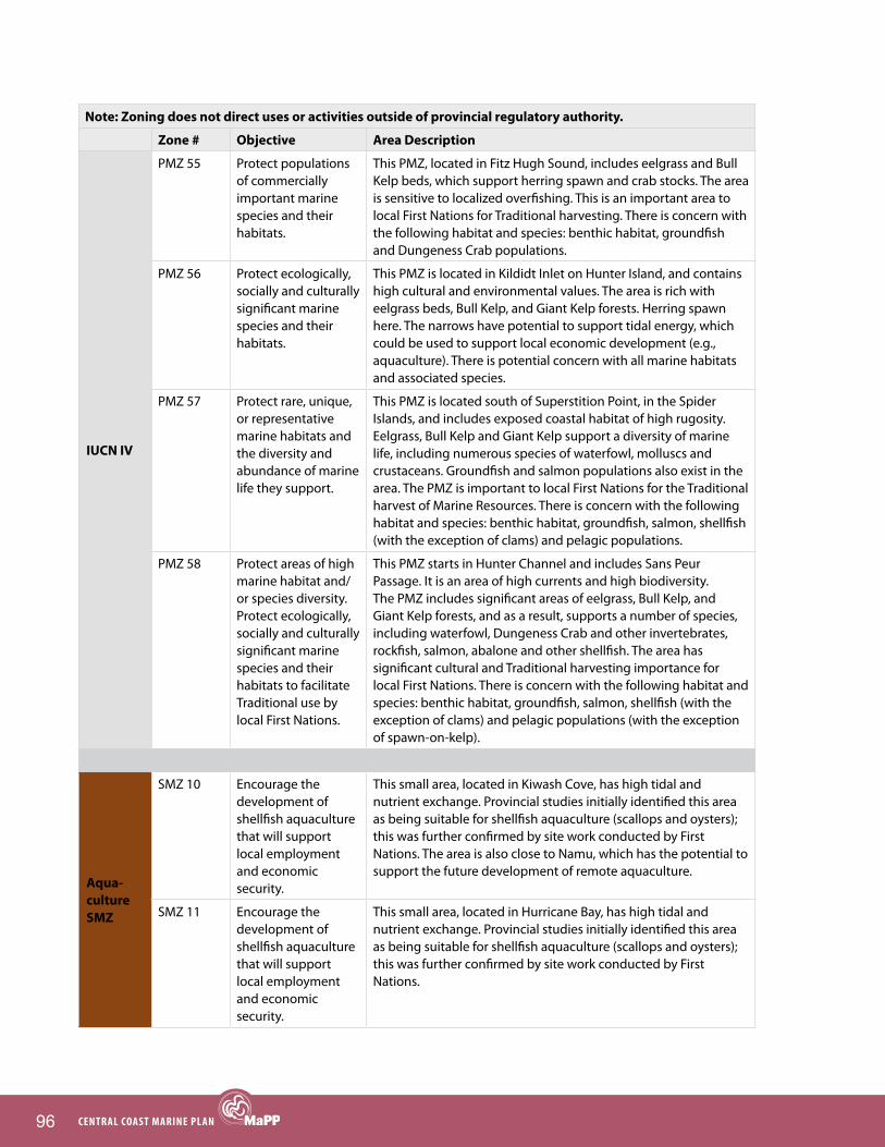
96 CENTRAL COAST MARINE PLAN
Note: Zoning does not direct uses or activities outside of provincial regulatory authority.
Zone # Objective Area Description
IUCN IV
PMZ 55 Protect populations of commercially important marine species and their habitats.
This PMZ, located in Fitz Hugh Sound, includes eelgrass and Bull Kelp beds, which support herring spawn and crab stocks. The area is sensitive to localized overfishing. This is an important area to local First Nations for Traditional harvesting. There is concern with the following habitat and species: benthic habitat, groundfish and Dungeness Crab populations.
PMZ 56 Protect ecologically, socially and culturally significant marine species and their habitats.
This PMZ is located in Kildidt Inlet on Hunter Island, and contains high cultural and environmental values. The area is rich with eelgrass beds, Bull Kelp, and Giant Kelp forests. Herring spawn here. The narrows have potential to support tidal energy, which could be used to support local economic development (e.g., aquaculture). There is potential concern with all marine habitats and associated species.
PMZ 57 Protect rare, unique, or representative marine habitats and the diversity and abundance of marine life they support.
This PMZ is located south of Superstition Point, in the Spider Islands, and includes exposed coastal habitat of high rugosity. Eelgrass, Bull Kelp and Giant Kelp support a diversity of marine life, including numerous species of waterfowl, molluscs and crustaceans. Groundfish and salmon populations also exist in the area. The PMZ is important to local First Nations for the Traditional harvest of Marine Resources. There is concern with the following habitat and species: benthic habitat, groundfish, salmon, shellfish (with the exception of clams) and pelagic populations.
PMZ 58 Protect areas of high marine habitat and/or species diversity. Protect ecologically, socially and culturally significant marine species and their habitats to facilitate Traditional use by local First Nations.
This PMZ starts in Hunter Channel and includes Sans Peur Passage. It is an area of high currents and high biodiversity. The PMZ includes significant areas of eelgrass, Bull Kelp, and Giant Kelp forests, and as a result, supports a number of species, including waterfowl, Dungeness Crab and other invertebrates, rockfish, salmon, abalone and other shellfish. The area has significant cultural and Traditional harvesting importance for local First Nations. There is concern with the following habitat and species: benthic habitat, groundfish, salmon, shellfish (with the exception of clams) and pelagic populations (with the exception of spawn-on-kelp).
Aqua-culture SMZ
SMZ 10 Encourage the development of shellfish aquaculture that will support local employment and economic security.
This small area, located in Kiwash Cove, has high tidal and nutrient exchange. Provincial studies initially identified this area as being suitable for shellfish aquaculture (scallops and oysters); this was further confirmed by site work conducted by First Nations. The area is also close to Namu, which has the potential to support the future development of remote aquaculture.
SMZ 11 Encourage the development of shellfish aquaculture that will support local employment and economic security.
This small area, located in Hurricane Bay, has high tidal and nutrient exchange. Provincial studies initially identified this area as being suitable for shellfish aquaculture (scallops and oysters); this was further confirmed by site work conducted by First Nations.

97ChAPTER 6: MARINE SPATIAL PLAN
Photo by Charles Short
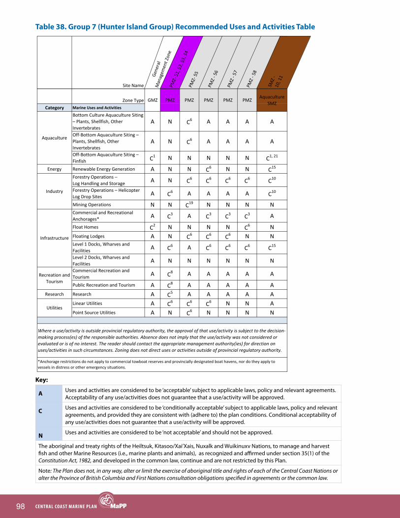
98 CENTRAL COAST MARINE PLAN
Table 38. Group 7 (Hunter Island Group) Recommended Uses and Activities Table
Key:
A Uses and activities are considered to be ‘acceptable’ subject to applicable laws, policy and relevant agreements. Acceptability of any use/activities does not guarantee that a use/activity will be approved.
C Uses and activities are considered to be ‘conditionally acceptable’ subject to applicable laws, policy and relevant agreements, and provided they are consistent with (adhere to) the plan conditions. Conditional acceptability of any use/activities does not guarantee that a use/activity will be approved.
N Uses and activities are considered to be ‘not acceptable’ and should not be approved.
The aboriginal and treaty rights of the Heiltsuk, Kitasoo/Xai’Xais, Nuxalk and Wuikinuxv Nations, to manage and harvest fish and other Marine Resources (i.e., marine plants and animals), as recognized and affirmed under section 35(1) of the Constitution Act, 1982, and developed in the common law, continue and are not restricted by this Plan.
Note: The Plan does not, in any way, alter or limit the exercise of aboriginal title and rights of each of the Central Coast Nations or alter the Province of British Columbia and First Nations consultation obligations specified in agreements or the common law.
Site Name
General
Managem
ent Zon
ePM
Z‐ 51, 52, 53, 54
PMZ‐ 55
PMZ ‐ 56
PMZ ‐ 57
PMZ ‐ 58
SMZ ‐
10, 11
PMZ PMZGMZAquaculture
SMZPMZ PMZ PMZZone Type
Category Marine Uses and Activities
Bottom Culture Aquaculture Siting – Plants, Shellfish, Other Invertebrates
A N C6 A A A A
Off‐Bottom Aquaculture Siting – Plants, Shellfish, Other Invertebrates
A N C6 A A A A
Off‐Bottom Aquaculture Siting – Finfish C1 N N N N N C1, 21
Energy Renewable Energy Generation A N N C6 N N C15
Forestry Operations – Log Handling and Storage A N C6 C6 C6 C6 C10
Forestry Operations – Helicopter Log Drop Sites A C6 A A A A C10
Mining Operations N N C19 N N N NCommercial and Recreational Anchorages* A C3 A C3 C3 C3 A
Float Homes C2 N N N N C6 NFloating Lodges A N C6 C6 C6 N NLevel 1 Docks, Wharves and Facilities A C6 A C6 C6 C6 C15
Level 2 Docks, Wharves and Facilities A N N N N N NCommercial Recreation and Tourism A C8 A A A A A
Public Recreation and Tourism A C8 A A A A AResearch Research A C5 A A A A A
Linear Utilities A C6 C6 C6 N N APoint Source Utilities A N C6 N N N N
PMZ
Utilities
Aquaculture
Industry
Infrastructure
Recreation and Tourism
Where a use/activity is outside provincial regulatory authority, the approval of that use/activity is subject to the decision‐making process(es) of the responsible authorities. Absence does not imply that the use/activity was not considered or evaluated or is of no interest. The reader should contact the appropriate management authority(ies) for direction on uses/activities in such circumstances. Zoning does not direct uses or activities outside of provincial regulatory authority.
PMZ
*Anchorage restrictions do not apply to commercial towboat reserves and provincially designated boat havens, nor do they apply to vessels in distress or other emergency situations.
GMZAquaculture
SMZPMZ PMZ PMZ

99ChAPTER 6: MARINE SPATIAL PLAN
Table 39. Group 7 (Hunter Island Group) conditional statements1
C1: Address the interests of the First Nation(s) in whose territory the application is proposed, ensuring that the site location is outside the provincial moratorium on marine finfish aquaculture tenures in tidal waters north of Aristazabal Island.
C2: Float homes are conditional on compliance with the provincial government Floating Home Community Policy.
C3: Disturbance of sensitive or critical features and habitat should be avoided; site limitations will be identified in an approved Protection Management Plan.
C5: Only research activities that will not disturb sensitive or critical features and habitats are acceptable.
C6: Should be compatible with conservation objectives of the Protection Management Zone; site limitations will be identified in an approved Protection Management Plan.
C8: Cultural sites may require particular conditions; site limitations will be identified in an approved Protection Management Plan.
C10: New log handling tenures are conditional on their impact on existing and future aquaculture operations. Optimal sites will be identified through detailed planning for Aquaculture SMZs.
C15: Only infrastructure that is used for aquaculture is acceptable.
C19: Only mining activities that are within the Hakai Conservation Study Area are acceptable. Mining in the rest of the zone is not acceptable.
C21: Open net cage finfish aquaculture is not considered acceptable.
Additional Considerations:
PMZ 51, 52, 53, 54 (IUCN II): Ecological and species values might be impacted by commercial fisheries, recreational fishing activity, transportation and temporary port vessel anchorage.
PMZ 55 (IUCN IV): Ecological and species values and sensitive benthic habitat might be impacted by commercial fisheries, recreational fishing activity and temporary port vessel anchorage.
PMZ 56 (IUCN IV): Ecological and species values might be impacted by commercial fisheries, recreational fishing activity and temporary port vessel anchorage.
PMZ 57 (IUCN IV): Ecological and species values and sensitive benthic habitat might be impacted by commercial fisheries, recreational fishing activity and temporary port vessel anchorage. Commercial and recreational values for clams exist and these activities would not impact the protection objective(s) for the area.
PMZ 58 (IUCN IV): Ecological and species values and sensitive benthic habitat might be impacted by commercial fisheries, recreational fishing activity and temporary port vessel anchorage. Commercial and recreational values for clams exist and these activities would not impact the protection objective(s) for the area. Spawn-on-kelp values also exist and these activities would not impact the protection objective(s) for the area.
1 Many conditional statements refer to Protection Management Plans that will be developed in the future. Until Protection Management Plans are developed, conditional activities should meet existing legislation and policy and consider local cultural and ecological values. Protection Management Plans may outline additional requirements.

100 CENTRAL COAST MARINE PLAN
Spatial Planning Group 8 (Calvert)
figure 16. Spatial Planning group 8 (Calvert)

101ChAPTER 6: MARINE SPATIAL PLAN
Table 40. Group 8 (Calvert) zone objectives and area descriptions
Note: Zoning does not direct uses or activities outside of provincial regulatory authority.
Zone # Objective Area Description
IUCN Ib
PMZ 59 Protect fragile eelgrass beds from all extractive and industrial activities.
Protect marine habitats that are important for various life history stages (e.g., juvenile or spawning areas, nursery grounds).
This small bay includes Bull Kelp and eelgrass beds, which are important habitats for a variety of species at different life stages. This PMZ is an important carbon sink.
IUCN II
PMZ 60 Protect eelgrass meadows, kelp beds, estuaries and other marine habitats that support high species diversity and abundance. Protect marine areas of high cultural value for local First Nations.
This is a network of estuaries that supports a complex ecosystem, which includes habitat for, and healthy populations of, Steelhead, Dungeness Crab, groundfish, invertebrates, shellfish and all five species of Pacific salmon. The area provides food, shelter and protection from predators for many juvenile fish and shellfish species, and plays an important role in the life cycles of shellfish, crabs, finfish, and red- and blue-listed shorebirds and waterfowl. The area provides important Marbled Murrelet at-sea habitat. This PMZ is a very important cultural area for local First Nations, and it is the location of a children’s camp that is run by the Heiltsuk.
PMZ 61 Protect eelgrass meadows, kelp beds, estuaries and other marine habitats that support high species diversity and abundance.
This PMZ contains eelgrass, Bull Kelp, and Giant Kelp ecosystems that support Pelagic Cormorant, rockfish, abalone, Gooseneck Barnacle, Geoduck, prawn, halibut, groundfish and Sockeye Salmon populations. The area also supports spawning herring and provides important Marbled Murrelet at-sea habitat.
PMZ 62 Protect marine habitats that are important for various life history stages (e.g., juvenile or spawning areas, nursery grounds).
This PMZ encompasses Elizabeth Lagoon and Fish Egg Inlet. It includes eelgrass and Bull Kelp beds and is a herring spawning area. The area also provides important juvenile and mature rockfish habitat. The PMZ overlaps the Fish Egg Rockfish Conservation Area and extends it out into Fitz Hugh Sound. This PMZ has cultural and Traditional harvesting significance for local First Nations.

102 CENTRAL COAST MARINE PLAN
Note: Zoning does not direct uses or activities outside of provincial regulatory authority.
Zone # Objective Area Description
IUCN IV
PMZ 63 Protect rare, unique, or representative marine habitats and the diversity and abundance of marine life they support. Protect marine areas of high cultural, historical and/or scientific value.
This PMZ encompasses Hakai Passage and Fitz Hugh Sound. The area is ecologically diverse and includes exposed shoreline, lagoons, tidal rapids, white sandy beaches, eelgrass and kelp forests, and haulouts. These habitats support many species of marine plants, birds, mammals (seals and whales), fish, invertebrates and shellfish. The area is very important to local First Nations, both culturally and as a Traditional harvest area. The area is the centre of the Hakai institute, an important research centre for the Central Coast. There is concern with benthic habitat and rockfish populations.
PMZ 64 Restore populations of declining or depleted marine species, and protect the habitats and ecosystem functions upon which they rely.
This PMZ, located off the southern end of Calvert Island, is a productive exposed coastal habitat with high rugosity. The area has high biodiversity, with significant concentrations of salmon that bring whales and other marine mammals to the area. It is an important bird foraging area. Eelgrass and kelp beds provide nursery habitat and protection for multiple juvenile fish species and invertebrates. Sea lion haulouts occur in the area. This location, in particular, contains large size classes of long-lived species of rockfish, and could help rebuild depleted populations in adjacent areas. The PMZ has high value for local First Nations regarding the Traditional harvest of Marine Resources. There is concern with the following habitat and species: benthic habitat, groundfish, salmon, shellfish (with the exception of Geoduck, Sea Cucumber and urchins) and pelagic populations.
PMZ 65 Protect marine habitats that are important for various life history stages (e.g., juvenile or spawning areas, nursery grounds).
This PMZ encompasses part of Fitz Hugh Sound. It includes eelgrass and Bull Kelp beds and is a herring spawning area. Much of the PMZ is sandy bottom habitat and is a halibut breeding area. The area provides important Marbled Murrelet at-sea habitat and is used extensively by humpback whales to feed. This PMZ has high tourism value and cultural and Traditional harvesting significance for local First Nations. There is concern with benthic habitat and groundfish populations.
PMZ 66 Protect ecologically, socially and culturally significant marine species and their habitats.
This PMZ, located off the northwest tip of Calvert Island, contains eelgrass, Bull Kelp, and Giant Kelp forests that support many invertebrate species, including Geoduck, and groundfish species. This area is culturally, ecologically and scientifically significant. There is potential concern with all marine habitats and associated species.
PMZ 67 Protect marine habitats that are important for various life history stages (e.g., juvenile or spawning areas, nursery grounds).
This area is located in Kwakume Inlet. Its eelgrass and kelp beds provide a nursery area for many marine species. The area provides food, shelter and protection from predators for many juvenile fish and shellfish species, and plays an important role in the life cycles of shellfish, crabs, finfish and waterfowl. The area supports a strong herring spawn and provides important Marbled Murrelet at-sea habitat. There is potential concern with all marine habitats and associated species.
PMZ 68 Protect important feeding, breeding, moulting, wintering, or resting sites. Protect populations of commercially important marine species and their habitats.
This area, located around Rankin Shoals and Kent Bank, has high rugosity and includes sea lion haulouts and important seabird areas. The area is important for rock fish and groundfish species, and has high value for local First Nations regarding the Traditional harvest of Marine Resources. There is concern with benthic habitat and groundfish populations.

103ChAPTER 6: MARINE SPATIAL PLAN
Note: Zoning does not direct uses or activities outside of provincial regulatory authority.
Zone # Objective Area Description
Renewable Energy SMZ
SMZ 12 Encourage the development of offshore wind energy generation that will support local employment and economic security.
This area, located off the west coast of Calvert Island in Queen Charlotte Sound, receives consistently high winds and has been estimated to receive mean annual wind energy in excess of 800 W/m2. This zone overlaps an Important Bird Area identified by Bird Studies Canada and Nature Canada, which should be taken into consideration during the planning and approval process for renewable energy projects.
Photo by Ian McAllister

104 CENTRAL COAST MARINE PLAN
Table 41. Group 8 (Calvert) Recommended Uses and Activities Table
Key:
A Uses and activities are considered to be ‘acceptable’ subject to applicable laws, policy and relevant agreements. Acceptability of any use/activities does not guarantee that a use/activity will be approved.
C Uses and activities are considered to be ‘conditionally acceptable’ subject to applicable laws, policy and relevant agreements, and provided they are consistent with (adhere to) the plan conditions. Conditional acceptability of any use/activities does not guarantee that a use/activity will be approved.
N Uses and activities are considered to be ‘not acceptable’ and should not be approved.
The aboriginal and treaty rights of the Heiltsuk, Kitasoo/Xai’Xais, Nuxalk and Wuikinuxv Nations, to manage and harvest fish and other Marine Resources (i.e., marine plants and animals), as recognized and affirmed under section 35(1) of the Constitution Act, 1982, and developed in the common law, continue and are not restricted by this Plan.
Note: The Plan does not, in any way, alter or limit the exercise of aboriginal title and rights of each of the Central Coast Nations or alter the Province of British Columbia and First Nations consultation obligations specified in agreements or the common law.
Site Name
General
Managem
ent Zon
ePM
Z‐59
PMZ‐60, 61, 62
PMZ ‐ 63
PMZ ‐ 64
PMZ ‐ 65
PMZ ‐ 66
PMZ ‐ 67
PMZ ‐ 68
SMZ ‐ 12
PMZ PMZPMZ PMZRenewable Energy SMZ
PMZ PMZ PMZ PMZGMZZone Type
Category Marine Uses and Activities
Bottom Culture Aquaculture Siting – Plants, Shellfish, Other Invertebrates
A N N A N A A A N N
Off‐Bottom Aquaculture Siting – Plants, Shellfish, Other Invertebrates
A N N A N A A A N N
Off‐Bottom Aquaculture Siting – Finfish C1 N N N N N N N N C1
Energy Renewable Energy Generation A N N N N N N N N A
Forestry Operations – Log Handling and Storage A N N C6 C6 C6 C6 C6 C6 C11
Forestry Operations – Helicopter Log Drop Sites A N C6 A A A A A A C11
Mining Operations N N N N N N N N N NCommercial and Recreational Anchorages* A N C3 A C3 A C3 C3 N A
Float Homes C2 N N N N N N N N NFloating Lodges A N N C6 N N C6 C6 N NLevel 1 Docks, Wharves and Facilities A C6,9 C6 A N A C6 C6 N C16
Level 2 Docks, Wharves and Facilities A N N N N N N N N NCommercial Recreation and Tourism A C6,8 C8 A A A A A A A
Public Recreation and Tourism A C6,8 C8 A A A A A A A
Research Research A C4 C5 A A A A A A ALinear Utilities A C6 C6 N N A C6 N N APoint Source Utilities A N N N N N N N N C16
Infrastructure
Recreation and Tourism
Where a use/activity is outside provincial regulatory authority, the approval of that use/activity is subject to the decision‐making process(es) of the responsible authorities. Absence does not imply that the use/activity was not considered or evaluated or is of no interest. The reader should contact the appropriate management authority(ies) for direction on uses/activities in such circumstances. Zoning does not direct uses or activities outside of provincial regulatory authority.
*Anchorage restrictions do not apply to commercial towboat reserves and provincially designated boat havens, nor do they apply to vessels in distress or other emergency situations.
Utilities
PMZ PMZPMZ PMZRenewable Energy SMZ
Industry
PMZ PMZ PMZ PMZ
Aquaculture
GMZ

105ChAPTER 6: MARINE SPATIAL PLAN
Table 42. Group 8 (Calvert) conditional statements1
C1: Address the interests of the First Nation(s) in whose territory the application is proposed, ensuring that the site location is outside the provincial moratorium on marine finfish aquaculture tenures in tidal waters north of Aristazabal Island.
C2: Float homes are conditional on compliance with the provincial government Floating Home Community Policy.
C3: Disturbance of sensitive or critical features and habitat should be avoided; site limitations will be identified in an approved Protection Management Plan.
C4: Only research activities that are non extractive and will not disturb sensitive or critical features and habitats are acceptable.
C5: Only research activities that will not disturb sensitive or critical features and habitats are acceptable.
C6: Should be compatible with conservation objectives of the Protection Management Zone; site limitations will be identified in an approved Protection Management Plan.
C8: Cultural sites may require particular conditions; site limitations will be identified in an approved Protection Management Plan.
C9: Infrastructure is required for service provision of the Protection Management Zone.
C11: Only forestry operations that do not impact or limit renewable energy operations are acceptable.
C16: Conditional on supporting the renewable energy industry or limiting any impacts to current renewable energy operations and future developments.
Additional Considerations:
PMZ 59 (IUCN Ib): Ecological and species values might be impacted by commercial fisheries, recreational fishing activity, transportation and temporary port vessel anchorage.
PMZ 60, 61, 62 (IUCN II): Ecological and species values might be impacted by commercial fisheries, recreational fishing activity, transportation and temporary port vessel anchorage.
PMZ 63 (IUCN IV): Ecological and species values and sensitive benthic habitat might be impacted by commercial fisheries and temporary port vessel anchorage. Recreational fishing values exist in the area and these activities would not impact the protection objective(s) for the area.
PMZ 64 (IUCN IV): Ecological and species values and sensitive benthic habitat might be impacted by commercial fisheries, recreational fishing activity and temporary port vessel anchorage. Commercial and recreational value for Geoduck, Sea Cucumber and urchins exist and these activities would not impact the protection objective(s) for the area.
PMZ 65, 68 (IUCN IV): Ecological and species values and sensitive benthic habitat might be impacted by commercial fisheries, recreational fishing activity and temporary port vessel anchorage.
PMZ 66, 67 (IUCN IV): Ecological and species values might be impacted by commercial fisheries, recreational fishing activity, and temporary port vessel anchorage.
1 Many conditional statements refer to Protection Management Plans that will be developed in the future. Until Protection Management Plans are developed, conditional activities should meet existing legislation and policy and consider local cultural and ecological values. Protection Management Plans may outline additional requirements.

106 CENTRAL COAST MARINE PLAN
Spatial Planning Group 9 (Penrose)
figure 17. Spatial Planning group 9 (Penrose)

107ChAPTER 6: MARINE SPATIAL PLAN
Table 43. Group 9 (Penrose) zone objectives and area descriptions
Note: Zoning does not direct uses or activities outside of provincial regulatory authority.
Zone # Objective Area Description
IUCN Ib
PMZ 69 Protect eelgrass meadows, kelp beds, estuaries and other marine habitats that support high species diversity and abundance.
This small bay includes eelgrass beds, which provide a nursery area for many marine and anadromous species. Eelgrass provides food, shelter and protection from predators for many juvenile fish and shellfish species, and it plays an important role in the life cycles of shellfish, crabs, finfish and waterfowl.
IUCN II
PMZ 70 Protect eelgrass meadows, kelp beds, estuaries and other marine habitats that support high species diversity and abundance.
This small bay includes eelgrass beds, which provide a nursery area for many marine and anadromous species. Eelgrass provides food, shelter and protection from predators for many juvenile fish and shellfish species, and it plays an important role in the life cycles of shellfish, crabs, finfish and waterfowl.
PMZ 71 Protect marine areas of high cultural and/or historical value, including areas of Traditional habitation and marine harvesting.
This area, located off the northeast tip of Penrose Island, has clam beds and supports populations of groundfish, salmon, waterfowl and prawns. This PMZ has high value for local First Nations Traditional harvest of Marine Resources.
PMZ 72 Protect important feeding, breeding, moulting, wintering, or resting sites.
This area is located mid-channel, approximately 4 km northwest of Duncanby Landing. It is an important bird area, which supports Pelagic Cormorants, and it has high Traditional harvest value for local First Nations.
PMZ 73 Protect ecologically, socially and culturally significant marine species and their habitats.
This area, located west of Penrose Island, includes shoreline habitat that is important for seaweed, and shellfish and other invertebrates. The area also provides important Marbled Murrelet at-sea habitat. This PMZ has cultural and Traditional harvesting significance for local First Nations.
IUCN IV
PMZ 74 Protect marine areas of high habitat and species diversity.
This PMZ, located in Pierce Bay, includes eelgrass beds and intertidal soft substrate habitat, which is unique on the Central Coast, and it provides habitat for bivalves. Eelgrass provides rearing areas for juvenile salmon. The area also supports shellfish, groundfish, rockfish and crab populations. There is potential concern with all marine habitats and associated species.
PMZ 75 Protect eelgrass meadows, kelp beds, estuaries and other marine habitats that support high species diversity and abundance.
Goose Bay includes productive eelgrass beds, which support crab and juvenile salmon. The area acts as a nursery for many marine and anadromous species. Eelgrass provides food, shelter and protection from predators for many juvenile fish and shellfish species, and it plays an important role in the life cycles of shellfish, crabs and finfish. Herring spawn here. This PMZ contains significant commercial spawn-on-kelp and commercial Geoduck fisheries. The PMZ has cultural and Traditional harvesting importance for local First Nations. There is potential concern with all marine habitats and associated species.

108 CENTRAL COAST MARINE PLAN
Note: Zoning does not direct uses or activities outside of provincial regulatory authority.
Zone # Objective Area Description
Aqua-culture SMZ
SMZ 13 Encourage the development of shellfish aquaculture that will support local employment and economic security.
This area is located on the east side of Penrose Island. Provincial studies initially identified this area as being suitable for shellfish aquaculture (scallops and oysters); this was further confirmed by site work conducted by First Nations.
SMZ 14 Encourage the development of shellfish aquaculture that will support local employment and economic security.
This area is located in Weeolk Pass. Provincial studies initially identified this area as being suitable for shellfish aquaculture (scallops and oysters); this was further confirmed by site work conducted by First Nations.
SMZ 15 Encourage the development of shellfish aquaculture that will support local employment and economic security.
This area is located between Ripon and Walbran Islands. Provincial studies initially identified this area as being suitable for shellfish aquaculture (scallops and oysters); this was further confirmed by site work conducted by First Nations.
Photo by Julie Carpenter

109ChAPTER 6: MARINE SPATIAL PLAN
Table 44. Group 9 (Penrose) Recommended Uses and Activities Table
Key:
AUses and activities are considered to be ‘acceptable’ subject to applicable laws, policy and relevant agreements. Acceptability of any use/activities does not guarantee that a use/activity will be approved.
CUses and activities are considered to be ‘conditionally acceptable’ subject to applicable laws, policy and relevant agreements, and provided they are consistent with (adhere to) the plan conditions. Conditional acceptability of any use/activities does not guarantee that a use/activity will be approved.
N Uses and activities are considered to be ‘not acceptable’ and should not be approved.
The aboriginal and treaty rights of the Heiltsuk, Kitasoo/Xai’Xais, Nuxalk and Wuikinuxv Nations, to manage and harvest fish and other Marine Resources (i.e., marine plants and animals), as recognized and affirmed under section 35(1) of the Constitution Act, 1982, and developed in the common law, continue and are not restricted by this Plan.Note: The Plan does not, in any way, alter or limit the exercise of aboriginal title and rights of each of the Central Coast Nations or alter the Province of British Columbia and First Nations consultation obligations specified in agreements or the common law.
Site Name
General
Managem
ent Zon
ePM
Z ‐ 69
PMZ ‐ 70, 71, 72,
73
PMZ ‐ 74
PMZ ‐ 75
SMZ ‐
13, 14, 15
PMZAquaculture
SMZPMZ PMZPMZGMZ
Zone Type
Category Marine Uses and Activities
Bottom Culture Aquaculture Siting – Plants, Shellfish, Other Invertebrates
A N N A A A
Off‐Bottom Aquaculture Siting – Plants, Shellfish, Other Invertebrates
A N N A A A
Off‐Bottom Aquaculture Siting – Finfish C1 N N N N C1
Energy Renewable Energy Generation A N N N N C15
Forestry Operations – Log Handling and Storage A N N C6 C6 C10
Forestry Operations – Helicopter Log Drop Sites A N C6 A A C10
Mining Operations N N N N N NCommercial and Recreational Anchorages* A N C3 A C3 A
Float Homes C2 N N N N NFloating Lodges A N N N N NLevel 1 Docks, Wharves and Facilities A C6,9 C6 A N C15
Level 2 Docks, Wharves and Facilities A N N N N NCommercial Recreation and Tourism A C6,8 C8 A A A
Public Recreation and Tourism A C6,8 C8 A A AResearch Research A C4 C5 A A A
Linear Utilities A C6 C6 N N APoint Source Utilities A N N N N N
PMZAquaculture
SMZ
Aquaculture
Industry
PMZ PMZPMZ
Recreation and Tourism
GMZ
*Anchorage restrictions do not apply to commercial towboat reserves and provincially designated boat havens, nor do they apply to vessels in distress or other emergency situations.
Utilities
Infrastructure
Where a use/activity is outside provincial regulatory authority, the approval of that use/activity is subject to the decision‐making process(es) of the responsible authorities. Absence does not imply that the use/activity was not considered or evaluated or is of no interest. The reader should contact the appropriate management authority(ies) for direction on uses/activities in such circumstances. Zoning does not direct uses or activities outside of provincial regulatory authority.

110 CENTRAL COAST MARINE PLAN
Table 45. Group 9 (Penrose) conditional statements1
C1: Address the interests of the First Nation(s) in whose territory the application is proposed, ensuring that the site location is outside the provincial moratorium on marine finfish aquaculture tenures in tidal waters north of Aristazabal Island.
C2: Float homes are conditional on compliance with the provincial government Floating Home Community Policy.
C3: Disturbance of sensitive or critical features and habitat should be avoided; site limitations will be identified in an approved Protection Management Plan.
C4: Only research activities that are non extractive and will not disturb sensitive or critical features and habitats are acceptable.
C5: Only research activities that will not disturb sensitive or critical features and habitats are acceptable.
C6: Should be compatible with conservation objectives of the Protection Management Zone; site limitations will be identified in an approved Protection Management Plan.
C8: Cultural sites may require particular conditions; site limitations will be identified in an approved Protection Management Plan.
C9: Infrastructure is required for service provision of the Protection Management Zone.
C10: New log handling tenures are conditional on their impact on existing and future aquaculture operations. Optimal sites will be identified through detailed planning for Aquaculture SMZs.
C15: Only infrastructure that is used for aquaculture is acceptable.
Additional Considerations:
PMZ 69 (IUCN Ib): Ecological and species values might be impacted by commercial fisheries, recreational fishing activity, transportation and temporary port vessel anchorage.
PMZ 70, 71, 72, 73 (IUCN II): Ecological and species values might be impacted by commercial fisheries, recreational fishing activity, transportation and temporary port vessel anchorage.
PMZ 74 (IUCN IV): Ecological and species values might be impacted by commercial fisheries, recreational fishing activity and temporary port vessel anchorage.
PMZ 75 (IUCN IV): Ecological and species values might be impacted by commercial fisheries, recreational fishing activity and temporary port vessel anchorage.
1 Many conditional statements refer to Protection Management Plans that will be developed in the future. Until Protection Management Plans are developed, conditional activities should meet existing legislation and policy and consider local cultural and ecological values. Protection Management Plans may outline additional requirements.

111ChAPTER 6: MARINE SPATIAL PLAN
Spatial Planning Group 10 (Rivers Inlet)
figure 18. Spatial Planning group 10 (Rivers Inlet)

112 CENTRAL COAST MARINE PLAN
Table 46. Group 10 (Rivers Inlet) zone objectives and area descriptions
Note: Zoning does not direct uses or activities outside of provincial regulatory authority.
Zone # Objective Area Description
IUCN Ib
PMZ 76 Protect eelgrass meadows, kelp beds, estuaries and other marine habitats that support high species diversity and abundance.
This area includes eelgrass beds, which provide a nursery area for many marine and anadromous species. Eelgrass provides food, shelter and protection from predators for many juvenile fish and shellfish species, and it plays an important role in the life cycles of shellfish, crabs, finfish and waterfowl.
PMZ 77 Protect eelgrass meadows, kelp beds, estuaries and other marine habitats that support high species diversity and abundance.
This PMZ, located in a small bay on the east shore of Rivers Inlet, contains fragile eelgrass beds, which provide a nursery area for many marine and anadromous species. Eelgrass provides food, shelter and protection from predators for many juvenile fish and shellfish species, and it plays an important role in the life cycles of shellfish, crabs, finfish and waterfowl.
PMZ 78 Protect eelgrass meadows, kelp beds, estuaries and other marine habitats that support high species diversity and abundance.
This area, located at the mouth of Newichy Creek, includes eelgrass beds, which provide a nursery area for many marine and anadromous species. Eelgrass provides food, shelter and protection from predators for many juvenile fish and shellfish species, and it plays an important role in the life cycles of shellfish, crabs, finfish and waterfowl.
IUCN II
PMZ 79 Protect eelgrass meadows, kelp beds, estuaries and other marine habitats that support high species diversity and abundance.
This area includes eelgrass beds, which provide a nursery area for many marine and anadromous species. Eelgrass provides food, shelter and protection from predators for many juvenile fish and shellfish species, and it plays an important role in the life cycles of shellfish, crabs, finfish and waterfowl.
PMZ 80 Protect marine habitats that are important for various life history stages (e.g., juvenile or spawning areas, nursery grounds).
This PMZ, located in Johnston Bay, includes eelgrass beds, which support herring spawn and multiple life stages of Coho, Chinook, Chum, Pink and Sockeye salmon, and it is an important crab-bearing area. The PMZ is an important Traditional harvesting area for local First Nations.
PMZ 81 Protect eelgrass meadows, kelp beds, estuaries and other marine habitats that support high species diversity and abundance.
This area, located at the head Draney Inlet, includes large eelgrass beds, which are important habitats for a variety of species at different life stages. The area supports populations of Coho, Chum and Pink Salmon fry, crab and herring. The area also provides important Marbled Murrelet at-sea habitat.
PMZ 82 Protect eelgrass meadows, kelp beds, estuaries and other marine habitats that support high species diversity and abundance. Protect marine areas adjacent to First Nations villages to support cultural and Traditional harvest values.
This area, located at the head of Rivers Inlet, contains large estuaries, eelgrass beds and seal haulouts. Rivers Inlet supports Steelhead and Chum, Chinook, Coho, Pink and Sockeye salmon, including some of the largest salmon runs on the coast. It also historically supported multiple Eulachon runs. In addition, the area supports other forage fish, groundfish, marine mammals, red- and blue-listed marine birds, shellfish and invertebrates, and herring spawn. The area also provides important Marbled Murrelet at-sea habitat. This area is very significant to local First Nations, both culturally and for the Traditional harvest of Marine Resources.

113ChAPTER 6: MARINE SPATIAL PLAN
Note: Zoning does not direct uses or activities outside of provincial regulatory authority.
Zone # Objective Area Description
IUCN IV
PMZ 83 Protect larval sources and marine habitats that are important for various life history stages (e.g., juvenile or spawning areas, nursery grounds).
This area covers Nelson Narrows and Hardy and Moses Inlets. It contains estuaries, eelgrass beds and herring and halibut spawning areas. The area also provides important Marbled Murrelet at-sea habitat. This PMZ has high cultural and Traditional harvest values for local First Nations. There is potential concern with all marine habitats and associated species.
PMZ 84 Protect eelgrass meadows, kelp beds, estuaries and other marine habitats that are critical for a variety of marine species
This PMZ, located in a small bay on the east shore of Rivers Inlet, contains eelgrass beds, which provide a nursery area for many marine and anadromous species. Eelgrass provides food, shelter and protection from predators for many juvenile fish and shellfish species, and it plays an important role in the life cycles of shellfish, crabs, finfish and waterfowl. There is potential concern with all marine habitats and associated species.
PMZ 85 Protect eelgrass meadows, kelp beds, estuaries and other marine habitats that support high species diversity and abundance.
A small area at the elbow of Draney Inlet, this area is part of a large estuary, which provides important habitat for a variety of species at different life stages. The area supports populations of Coho, Chum and Pink Salmon fry, Dungeness crab and herring. There is potential concern with all marine habitats and associated species.
Renewable Energy SMZ
SMZ 16 Encourage the development of tidal energy generation that will support local employment and economic security.
This area, located in the narrows at the mouth of Draney Inlet, has strong tidal flow that has been identified as being able to generate 51–100 MW of energy. Tidal capability and suitability was confirmed with local knowledge.
Aqua-culture SMZ
SMZ 17 Encourage the development of shellfish aquaculture that will support local employment and economic security.
This area is located in the narrows at the mouth of Draney inlet. Provincial studies initially identified this area as being suitable for shellfish aquaculture (scallops and oysters); this was further confirmed by site work and pilot studies conducted by First Nations.
SMZ 18 Encourage the development of shellfish aquaculture that will support local employment and economic security.
This area is located in a small inlet on the southeast end of Walbran Island. Provincial studies initially identified this area as being suitable for shellfish aquaculture (scallops and oysters); this was further confirmed by site work and pilot studies conducted by First Nations.

114 CENTRAL COAST MARINE PLAN
Table 47. Group 10 (Rivers Inlet) Recommended Uses and Activities Table
Key:
A Uses and activities are considered to be ‘acceptable’ subject to applicable laws, policy and relevant agreements. Acceptability of any use/activities does not guarantee that a use/activity will be approved.
C Uses and activities are considered to be ‘conditionally acceptable’ subject to applicable laws, policy and relevant agreements, and provided they are consistent with (adhere to) the plan conditions. Conditional acceptability of any use/activities does not guarantee that a use/activity will be approved.
N Uses and activities are considered to be ‘not acceptable’ and should not be approved.
The aboriginal and treaty rights of the Heiltsuk, Kitasoo/Xai’Xais, Nuxalk and Wuikinuxv Nations, to manage and harvest fish and other Marine Resources (i.e., marine plants and animals), as recognized and affirmed under section 35(1) of the Constitution Act, 1982, and developed in the common law, continue and are not restricted by this Plan.
Note: The Plan does not, in any way, alter or limit the exercise of aboriginal title and rights of each of the Central Coast Nations or alter the Province of British Columbia and First Nations consultation obligations specified in agreements or the common law.
Site Name
General
Managem
ent Zon
ePM
Z ‐ 7
6, 77, 78
PMZ ‐ 79, 80, 81, 82
PMZ ‐ 83
PMZ ‐ 84
PMZ‐ 85
SMZ ‐ 16
SMZ ‐
17, 18
PMZ PMZGMZ PMZ PMZAquaculture
SMZRenewable Energy SMZ
PMZZone Type
Category Marine Uses and Activities
Bottom Culture Aquaculture Siting – Plants, Shellfish, Other Invertebrates A N N C6 C6 C6 N AOff‐Bottom Aquaculture Siting – Plants, Shellfish, Other Invertebrates A N N C6 C6 C6 N A
Off‐Bottom Aquaculture Siting – Finfish C1 N N N N N C1 C1
Energy Renewable Energy Generation A N N C6 C6 C6 A C15
Forestry Operations – Log Handling and Storage A N N A C6 C6 C11 C10
Forestry Operations – Helicopter Log Drop Sites A N C6 A A A C11 C10
Mining Operations N N N N N N N NCommercial and Recreational Anchorages* A N C3 C3 C3 C3 A A
Float Homes C2 N N N N N N NFloating Lodges A N N N N N N NLevel 1 Docks, Wharves and Facilities A C6,9 C6 A A A C16 C15
Level 2 Docks, Wharves and Facilities A N N N N N N NCommercial Recreation and Tourism A C6,8 C8 A A A A APublic Recreation and Tourism A C6,8 C8 A A A A A
Research Research A C4 C5 A A A A ALinear Utilities A C6 C6 A A A A APoint Source Utilities A N N N N N C16 N
Aquaculture
Industry
Infrastructure
Recreation and Tourism
PMZ PMZGMZ PMZ PMZ
*Anchorage restrictions do not apply to commercial towboat reserves and provincially designated boat havens, nor do they apply to vessels in distress or other emergency situations.
Where a use/activity is outside provincial regulatory authority, the approval of that use/activity is subject to the decision‐making process(es) of the responsible authorities. Absence does not imply that the use/activity was not considered or evaluated or is of no interest. The reader should contact the appropriate management authority(ies) for direction on uses/activities in such circumstances. Zoning does not direct uses or activities outside of provincial regulatory authority.
Utilities
Aquaculture SMZ
Renewable Energy SMZ
PMZ

115ChAPTER 6: MARINE SPATIAL PLAN
Table 48. Group 10 (Rivers Inlet) conditional statements1
C2: Float homes are conditional on compliance with the provincial government Floating Home Community Policy.
C3: Disturbance of sensitive or critical features and habitat should be avoided; site limitations will be identified in an approved Protection Management Plan.
C4: Only research activities that are non extractive and will not disturb sensitive or critical features and habitats are acceptable.
C5: Only research activities that will not disturb sensitive or critical features and habitats are acceptable.
C6: Should be compatible with conservation objectives of the Protection Management Zone; site limitations will be identified in an approved Protection Management Plan.
C8: Cultural sites may require particular conditions; site limitations will be identified in an approved Protection Management Plan.
C9: Infrastructure is required for service provision of the Protection Management Zone.
C10: New log handling tenures are conditional on their impact on existing and future aquaculture operations. Optimal sites will be identified through detailed planning for Aquaculture SMZs.
C11: Only forestry operations that do not impact or limit renewable energy operations are acceptable.
C15: Only infrastructure that is used for aquaculture is acceptable.
C16: Conditional on supporting the renewable energy industry or limiting any impacts to current renewable energy operations and future developments.
Additional Considerations:
PMZ 76, 77, 78 (IUCN Ib): Ecological and species values might be impacted by commercial fisheries, recreational fishing activity, transportation and temporary port vessel anchorage.
PMZ 79, 80, 81, 82 (IUCN II): Ecological and species values might be impacted by commercial fisheries, recreational fishing activity, transportation and temporary port vessel anchorage.
PMZ 83, 84, 85 (IUCN IV): Ecological and species values might be impacted by commercial fisheries, recreational fishing activity and temporary port vessel anchorage.
1 Many conditional statements refer to Protection Management Plans that will be developed in the future. Until Protection Management Plans are developed, conditional activities should meet existing legislation and policy and consider local cultural and ecological values. Protection Management Plans may outline additional requirements.
Photo by Charles Short

116 CENTRAL COAST MARINE PLAN
Spatial Planning Group 11 (Burke/Fisher)
figure 19. Spatial Planning group 11 (burke/fisher)
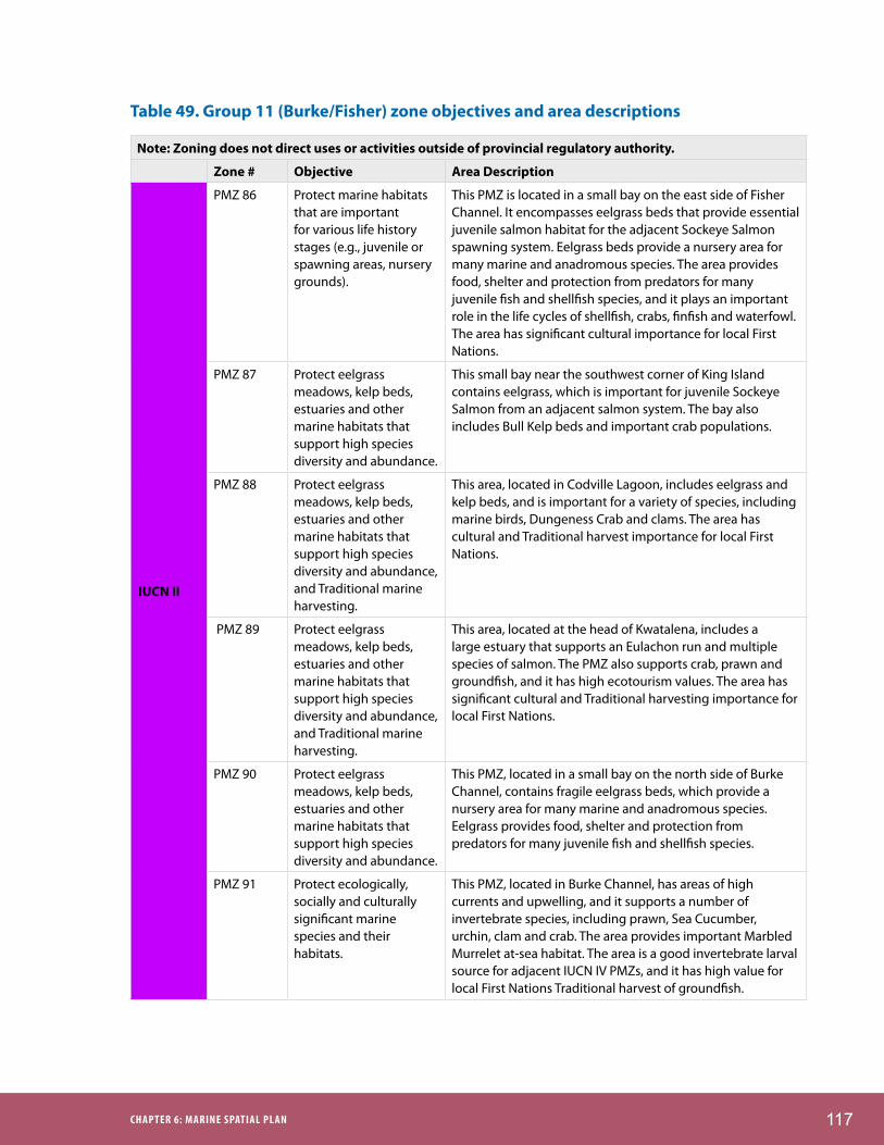
117ChAPTER 6: MARINE SPATIAL PLAN
Table 49. Group 11 (Burke/Fisher) zone objectives and area descriptions
Note: Zoning does not direct uses or activities outside of provincial regulatory authority.
Zone # Objective Area Description
IUCN II
PMZ 86 Protect marine habitats that are important for various life history stages (e.g., juvenile or spawning areas, nursery grounds).
This PMZ is located in a small bay on the east side of Fisher Channel. It encompasses eelgrass beds that provide essential juvenile salmon habitat for the adjacent Sockeye Salmon spawning system. Eelgrass beds provide a nursery area for many marine and anadromous species. The area provides food, shelter and protection from predators for many juvenile fish and shellfish species, and it plays an important role in the life cycles of shellfish, crabs, finfish and waterfowl. The area has significant cultural importance for local First Nations.
PMZ 87 Protect eelgrass meadows, kelp beds, estuaries and other marine habitats that support high species diversity and abundance.
This small bay near the southwest corner of King Island contains eelgrass, which is important for juvenile Sockeye Salmon from an adjacent salmon system. The bay also includes Bull Kelp beds and important crab populations.
PMZ 88 Protect eelgrass meadows, kelp beds, estuaries and other marine habitats that support high species diversity and abundance, and Traditional marine harvesting.
This area, located in Codville Lagoon, includes eelgrass and kelp beds, and is important for a variety of species, including marine birds, Dungeness Crab and clams. The area has cultural and Traditional harvest importance for local First Nations.
PMZ 89 Protect eelgrass meadows, kelp beds, estuaries and other marine habitats that support high species diversity and abundance, and Traditional marine harvesting.
This area, located at the head of Kwatalena, includes a large estuary that supports an Eulachon run and multiple species of salmon. The PMZ also supports crab, prawn and groundfish, and it has high ecotourism values. The area has significant cultural and Traditional harvesting importance for local First Nations.
PMZ 90 Protect eelgrass meadows, kelp beds, estuaries and other marine habitats that support high species diversity and abundance.
This PMZ, located in a small bay on the north side of Burke Channel, contains fragile eelgrass beds, which provide a nursery area for many marine and anadromous species. Eelgrass provides food, shelter and protection from predators for many juvenile fish and shellfish species.
PMZ 91 Protect ecologically, socially and culturally significant marine species and their habitats.
This PMZ, located in Burke Channel, has areas of high currents and upwelling, and it supports a number of invertebrate species, including prawn, Sea Cucumber, urchin, clam and crab. The area provides important Marbled Murrelet at-sea habitat. The area is a good invertebrate larval source for adjacent IUCN IV PMZs, and it has high value for local First Nations Traditional harvest of groundfish.

118 CENTRAL COAST MARINE PLAN
Note: Zoning does not direct uses or activities outside of provincial regulatory authority.
Zone # Objective Area Description
IUCN IV
PMZ 92 Protect ecologically, socially and culturally significant marine species and their habitats to facilitate Traditional use by local First Nations.
This inland channel is located west of Kwatna Inlet in Burke Channel. Its habitat protects small, sensitive groundfish populations, invertebrate species that act as a larval source for adjacent areas, and a salmon system that is currently under restoration. This location, in particular, is one of a few inner coast areas that contains large size classes of long-lived species of rockfish, and it could help rebuild depleted populations in adjacent areas. This PMZ is an important Traditional harvest area for local First Nations. There is concern with the following habitat and species: benthic habitat, groundfish, prawn and Dungeness Crab populations.
PMZ 93 Protect ecologically, socially and culturally significant marine species and their habitats
The head of Kwatna Inlet, this area supports important Pink, Coho, Chinook, Chum and Sockeye salmon runs, as well as an Eulachon run. The area is important for Dungeness Crab, prawn and groundfish and has high ecotourism values. The area has significant cultural and Traditional harvesting importance for local First Nations. There is potential concern with all marine habitats and associated species.
PMZ 94 Protect ecologically, socially and culturally significant marine species and their habitats
This area, located in Kwatalena, supports an Eulachon run and multiple species of salmon. The PMZ also supports crab, prawn and groundfish, and it has high ecotourism values. The area has significant cultural and Traditional harvesting importance for local First Nations. There is potential concern with all marine habitats and associated species
PMZ 95 Protect rare, unique, or representative marine habitats and the diversity and abundance of marine life they support. Restore populations of declining or depleted marine species, and protect the habitats and ecosystem functions upon which they rely.
This small bay off of Burke Channel is ecologically rich. This PMZ is adjacent to a channel with high currents and upwelling, and it contains a unique large estuary system that supports an abundance of species, including a Steelhead system, and Chum, Pink, Coho and Sockeye Salmon. The bay has a unique sandy bottom and eelgrass beds, and it provides excellent habitat for halibut and crab. The area also supports rockfish populations. The PMZ has declining stocks and is in need of rehabilitation. Nootum has the potential for research and tourism opportunities, and it has cultural and Traditional harvest significance for local First Nations. There is potential concern with all marine habitats and associated species.
PMZ 96 Protect marine areas of high cultural and historical value, including areas of Traditional habitation and marine harvesting.
This PMZ is in a small bay off Burke Channel and is adjacent to a channel with high currents and upwelling. It has eelgrass beds and Bull Kelp beds that support important crab, groundfish and salmon populations. The area has high Traditional harvest importance for local First Nations. There is potential concern with all marine habitats and associated species.

119ChAPTER 6: MARINE SPATIAL PLAN
Note: Zoning does not direct uses or activities outside of provincial regulatory authority.
Zone # Objective Area Description
PMZ 97 Protect eelgrass meadows, kelp beds, estuaries and other marine habitats that support high species diversity and abundance, and Traditional marine harvesting.
This area is located in Restoration Bay and Burke Channel. It includes an estuary and eelgrass beds, and supports herring spawn, crab, prawns, out-migrating salmon, clams and groundfish. This PMZ is an important Traditional harvest area for local First Nations. There is concern with the following habitat and species: benthic habitat, groundfish, prawn and Dungeness Crab populations.
IUCN IV PMZ 98 Protect eelgrass meadows, kelp beds, estuaries and other marine habitats that support high species diversity and abundance.
This PMZ, located in a small bay on the north side of Burke Channel, is adjacent to eelgrass beds, which provide a nursery area for many marine and anadromous species. Eelgrass provides food, shelter and protection from predators for many juvenile fish and shellfish species. There is potential concern with all marine habitats and associated species
PMZ 99 Protect ecologically, socially and culturally significant marine species and their habitats
A small section of shoreline habitat on the north side of Burke Channel, this area includes habitat for a number of invertebrate species, including prawn, sea cucumber, urchin, clam and crab. There is potential concern with all marine habitats and associated species
PMZ 100 Protect ecologically, socially and culturally significant marine species and their habitats
A small section of shoreline habitat on the north side of Burke Channel. The PMZ is prone to high winds and significant water turbulence. The area includes habitat for a number of invertebrate species, including prawn, sea cucumber, urchin, clam and crab. There is potential concern with all marine habitats and associated species
Aqua-culture SMZ
SMZ 19 Encourage the development of shellfish aquaculture that will support local employment and economic security.
This area, located in Evans Inlet, was confirmed by site work conducted by First Nations. It is located near processing and distribution facilities.
Area Requires More Detailed Planning
1 N/A This area contains a variety of ecological, economic, cultural and social values which will be considered during more detailed planning.

120 CENTRAL COAST MARINE PLAN
Table 50. Group 11 (Burke/Fisher) Recommended Uses and Activities Table
Key:
A Uses and activities are considered to be ‘acceptable’ subject to applicable laws, policy and relevant agreements. Acceptability of any use/activities does not guarantee that a use/activity will be approved.
C Uses and activities are considered to be ‘conditionally acceptable’ subject to applicable laws, policy and relevant agreements, and provided they are consistent with (adhere to) the plan conditions. Conditional acceptability of any use/activities does not guarantee that a use/activity will be approved.
N Uses and activities are considered to be ‘not acceptable’ and should not be approved.
The aboriginal and treaty rights of the Heiltsuk, Kitasoo/Xai’Xais, Nuxalk and Wuikinuxv Nations, to manage and harvest fish and other Marine Resources (i.e., marine plants and animals), as recognized and affirmed under section 35(1) of the Constitution Act, 1982, and developed in the common law, continue and are not restricted by this Plan.
Note: The Plan does not, in any way, alter or limit the exercise of aboriginal title and rights of each of the Central Coast Nations or alter the Province of British Columbia and First Nations consultation obligations specified in agreements or the common law.
Site Name
General
Managem
ent Zon
ePM
Z ‐ 86, 87, 88, 89,
90, 91
PMZ ‐ 92
PMZ ‐ 93
PMZ ‐ 94
PMZ ‐ 95
PMZ ‐ 96
PMZ ‐ 97
PMZ ‐ 98
PMZ ‐ 99
PMZ ‐ 100
SMZ ‐ 19
PMZGMZAquaculture
SMZPMZ PMZ PMZ PMZPMZ PMZPMZPMZ PMZ
Zone Type
Category Marine Uses and Activities
Bottom Culture Aquaculture Siting – Plants, Shellfish, Other Invertebrates
A N N N N A A N N N N A
Off‐Bottom Aquaculture Siting – Plants, Shellfish, Other Invertebrates
A N N N N A A N N N N A
Off‐Bottom Aquaculture Siting – Finfish C1 N N N N C1 N N N N N C1
Energy Renewable Energy Generation A N N N N N N N N N N C15
Forestry Operations – Log Handling and Storage A N A C6 C6 C6 C6 A C6 C6 C6 C10
Forestry Operations – Helicopter Log Drop Sites A C6 A A A A A A A A A C10
Mining Operations N N N N N N N N N N N NCommercial and Recreational Anchorages* A C3 A C3 C3 A A A C3 C3 C3 A
Float Homes C2 N N N N N N N N N N NFloating Lodges A N A N N N N A N N N NLevel 1 Docks, Wharves and Facilities A C6 A C6 C6 A A A C6 C6 C6 C15
Level 2 Docks, Wharves and Facilities A N N N N N N N N N N NCommercial Recreation and Tourism A C8 A C8 C8 A A A C8 C8 C8 APublic Recreation and Tourism A C8 A C8 C8 A A A C8 C8 C8 A
Research Research A C5 A C5 C5 A A A C5 C5 C5 ALinear Utilities A C6 N C6 C6 A A N C6 C6 C6 APoint Source Utilities A N N N N N N N N N N N
PMZ
Utilities
Aquaculture
Industry
Infrastructure
Recreation/ Tourism
Where a use/activity is outside provincial regulatory authority, the approval of that use/activity is subject to the decision‐making process(es) of the responsible authorities. Absence does not imply that the use/activity was not considered or evaluated or is of no interest. The reader should contact the appropriate management authority(ies) for direction on uses/activities in such circumstances. Zoning does not direct uses or activities outside of provincial regulatory authority.
*Anchorage restrictions do not apply to commercial towboat reserves and provincially designated boat havens, nor do they apply to vessels in distress or other emergency situations.
GMZAquaculture
SMZPMZ PMZ PMZ PMZPMZ PMZPMZPMZ PMZ

121ChAPTER 6: MARINE SPATIAL PLAN
Table 51. Group 11 (Burke/Fisher) conditional statements1
C1: Address the interests of the First Nation(s) in whose territory the application is proposed, ensuring that the site location is outside the provincial moratorium on marine finfish aquaculture tenures in tidal waters north of Aristazabal Island.
C2: Float homes are conditional on compliance with the provincial government Floating Home Community Policy.
C3: Disturbance of sensitive or critical features and habitat should be avoided; site limitations will be identified in an approved Protection Management Plan.
C5: Only research activities that will not disturb sensitive or critical features and habitats are acceptable.
C6: Should be compatible with conservation objectives of the Protection Management Zone; site limitations will be identified in an approved Protection Management Plan.
C8: Cultural sites may require particular conditions; site limitations will be identified in an approved Protection Management Plan.
C10: New log handling tenures are conditional on their impact on existing and future aquaculture operations. Optimal sites will be identified through detailed planning for Aquaculture SMZs.
C15: Only infrastructure that is used for aquaculture is acceptable.
Additional Considerations:
PMZ 86, 87, 88, 89, 90, 91 (IUCN II): Ecological and species values might be impacted by commercial fisheries, recreational fishing activity, transportation and temporary port vessel anchorage.
PMZ 92, 93, 94, 97, 98, 99, 100 (IUCN IV): Ecological and species values and sensitive benthic habitats might be impacted by commercial fisheries, recreational fishing activity and temporary port vessel anchorage
PMZ 95, 96 (IUCN IV): Ecological and species values might be impacted by commercial fisheries, recreational fishing activity and temporary port vessel anchorage.
1 Many conditional statements refer to Protection Management Plans that will be developed in the future. Until Protection Management Plans are developed, conditional activities should meet existing legislation and policy and consider local cultural and ecological values. Protection Management Plans may outline additional requirements.
Photo by Ian McAllister
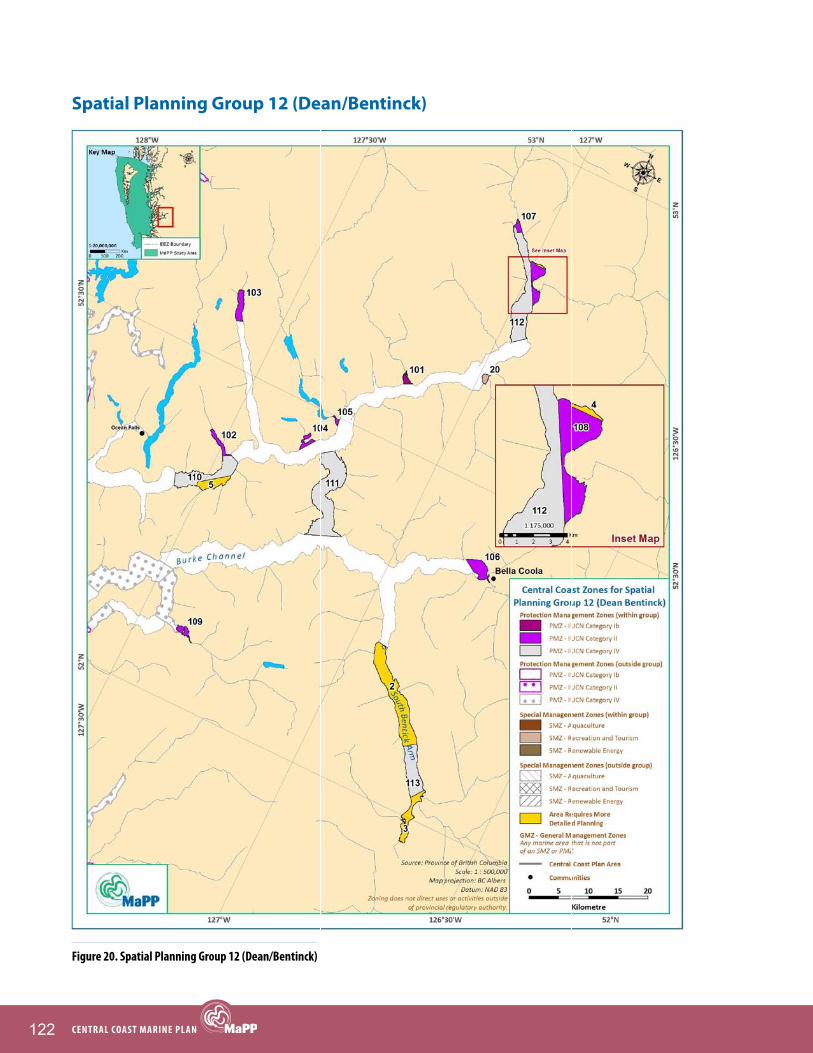
122 CENTRAL COAST MARINE PLAN
Spatial Planning Group 12 (Dean/Bentinck)
figure 20. Spatial Planning group 12 (Dean/bentinck)

123ChAPTER 6: MARINE SPATIAL PLAN
Table 52. Group 12 (Dean/Bentinck) zone objectives and area descriptions
Note: Zoning does not direct uses or activities outside of provincial regulatory authority.
Zone # Objective Area Description
IUCN Ib
PMZ 101 Protect marine areas of high cultural value, including areas of Traditional habitation and marine harvesting.
This estuary, located in Skowsquilts Bay, supports Sockeye, Pink and Coho Salmon populations and provides Marbled Murrelet feeding habitat. The area includes many sensitive cultural features and has cultural significance for local First Nations.
IUCN II
PMZ 102 Protect marine habitats important for various life history stages (e.g., juvenile or spawning areas, nursery grounds).
This PMZ, located in Elcho Harbour, includes estuarine habitat, which supports Chum, Coho, Pink and Sockeye Salmon populations and multiple invertebrate species. The area is a larval source for adjacent areas. This area is also important to local First Nations, both culturally and for the Traditional harvest of Marine Resources.
PMZ 103 Protect larval sources and marine habitats important for various life history stages (e.g., juvenile or spawning areas, nursery grounds).
Long narrow inlets on the Central Coast have unique and biologically isolated invertebrate populations that require local larval dispersal to maintain healthy population levels. This PMZ contains estuaries that are used by Chum, Coho and Pink Salmon that spawn in adjacent rivers. Decomposing salmon from these systems support local prawn and crab populations, which act as a larval source for the rest of the inlet and adjacent waters.
PMZ 104 Protect larval sources and marine habitats important for various life history stages (e.g., spawning areas, nursery areas).
This PMZ is located at Eucott Bay and is ecologically unique for inner coastal fjord habitat. The bay includes eelgrass, important Pink, Coho and Chum Salmon systems, and crab habitat, and it is one of the few areas on the inner coast that supports halibut populations. The area is also an important estuary for many bird species, as well as bears. The area provides at-sea habitat for Marbled Murrelets, and has high tourism values and high cultural and Traditional importance for First Nations.
PMZ 105 Protect larval sources and marine habitats important for various life history stages (e.g., spawning areas, nursery areas).
This estuarine area, located in Nascall Bay, is important to crab species and once supported a Sockeye Salmon system, which is in need of restoration. The area has high tourism values and significant cultural importance for First Nations.

124 CENTRAL COAST MARINE PLAN
Note: Zoning does not direct uses or activities outside of provincial regulatory authority.
Zone # Objective Area Description
IUCN II
PMZ 106 Protect rare, unique, or representative marine habitats and the diversity and abundance of marine life they support.
This PMZ, located at the top of North Bentinck Arm, is an important estuary for migratory birds, and it contains herring spawn, prawns, high density crab stocks, and Eulachon runs. Sea urchin habitat on the inner coast is limited, but some occurs in this area. The PMZ is a culturally significant and important Traditional harvest area for local First Nations.
PMZ 107 Protect eelgrass meadows, kelp beds, estuaries and other marine habitats that are critical for a variety of marine fish and invertebrate species. Protect larval sources and marine habitats important for various life history stages (e.g., juvenile or spawning areas, nursery grounds).
This PMZ, located in Kimsquit Narrows, encompasses a large estuary. It contains important habitat for Chum, Coho, Chinook, Pink and Sockeye salmon, as well as Steelhead and invertebrate habitat. The area provides food, shelter and protection from predators for many juvenile fish and shellfish species, and it plays an important role in the life cycles of shellfish, crabs, finfish and waterfowl. The area provides important Marbled Murrelet at-sea habitat. The area is very significant culturally for local First Nations.
PMZ 108 Protect eelgrass meadows, kelp beds, estuaries and other marine habitats that are critical for a variety of marine fish and invertebrate species. Protect larval sources and marine habitats important for various life history stages (e.g., juvenile or spawning areas, nursery grounds).
This PMZ, located in Kimsquit Narrows, encompasses a large estuary. It contains important habitat for Chum, Coho, Chinook, Pink and Sockeye salmon, as well as Steelhead and invertebrate habitat. The area provides food, shelter and protection from predators for many juvenile fish and shellfish species, and it plays an important role in the life cycles of shellfish, crabs, finfish and waterfowl. The area provides important Marbled Murrelet at-sea habitat. Rare saltwater shore spawning Chum Salmon spawn in this estuary. The area is very significant culturally for local First Nations.
PMZ 109 Protect eelgrass meadows, kelp beds, estuaries and other marine habitats that support high species diversity and abundance, and Traditional marine harvesting.
At the end of Kwatna Inlet, this area includes one of the largest estuaries in the Plan Area and supports Pink, Coho, Chinook, Chum and Sockeye salmon, as well as Rainbow Trout, Steelhead and Dolly Varden. It provides important waterfowl habitat and supports waterbird species at risk, providing Marbled Murrelet marine habitat. The estuary also supports an Eulachon run, Dungeness Crab, prawn and groundfish and has high ecotourism values. The area has significant cultural and Traditional harvesting importance for local First Nations.

125ChAPTER 6: MARINE SPATIAL PLAN
Note: Zoning does not direct uses or activities outside of provincial regulatory authority.
Zone # Objective Area Description
IUCN IV
PMZ 110 Protect ecologically, socially and culturally significant marine species and their habitats
This area, located in Dean Channel outside of Elcho Harbour, is characteristic deep fjord habitat, which supports rockfish and prawn populations. There is concern with the following habitat and species: benthic habitat, rockfish and prawn populations.
PMZ 111 Protect ecologically, socially and culturally significant marine species and their habitats to facilitate Traditional use by local First Nations.
Labouchere Channel is an area where waters from Dean and Burke Channels mix. As a result ,the area has high productivity, which supports forage fish, including herring spawn, and in turn, many other fish and bird species, as well as marine mammals. The area provides important Marbled Murrelet at-sea habitat. The protected, calm waters of Labouchere Channel provide a safe harvesting area for local First Nations, and the site is an important commercial fishing area. There is concern with the following habitat and species: benthic habitat, groundfish, shellfish and pelagic populations.
PMZ 112 Protect eelgrass meadows, kelp beds, estuaries and other marine habitats that are critical for a variety of marine fish and invertebrate species. Protect larval sources and marine habitats important for various life history stages (e.g., juvenile or spawning areas, nursery grounds).
This PMZ, located in Kimsquit Narrows, is adjacent to a large estuary. It contains important habitat for Chum, Coho, Chinook, Pink and Sockeye salmon, as well as Steelhead and invertebrate habitat. The area acts as a larval source for the adjacent GMZ in Dean Channel. The area provides food, shelter and protection from predators for many juvenile fish and shellfish species, and it plays an important role in the life cycles of shellfish, crabs, finfish and waterfowl. The area provides important Marbled Murrelet at-sea habitat. The area is very significant culturally for local First Nations. There is potential concern with all marine habitats and associated species
PMZ 113 Protect ecologically, socially and culturally significant species and their habitats to facilitate Traditional use by local First Nations.
This portion of South Bentinck Arm includes eelgrass habitat that provides crab and herring habitat. The area also supports a large prawn population. The area has significant cultural value for local First Nations and has high potential for ecotourism. There is concern with the following habitat and species: benthic habitat, herring, prawn and Dungeness Crab populations.
Recreation and Tourism SMZ
SMZ 20 Encourage the development of low-impact tourism opportunities that will support local employment and economic security.
This pristine area, located in the bay outside Jump Across Creek, has unique ecological features, good nature viewing opportunities and cultural sites that are suitable for First Nations cultural tourism and commercial ecotourism ventures.

126 CENTRAL COAST MARINE PLAN
Note: Zoning does not direct uses or activities outside of provincial regulatory authority.
Zone # Objective Area Description
Area Requires More Detailed Planning
2 N/A This area contains a variety of ecological, economic, cultural and social values which will be considered during more detailed planning.
3 N/A This area contains a variety of ecological, economic, cultural and social values which will be considered during more detailed planning.
4 N/A This area contains a variety of ecological, economic, cultural and social values which will be considered during more detailed planning.
5 N/A This area contains a variety of ecological, economic, cultural and social values which will be considered during more detailed planning.
Photo by Julie Carpenter

127ChAPTER 6: MARINE SPATIAL PLAN
Table 53. Group 12 (Dean/Bentinck) Recommended Uses and Activities Table
Key:
A Uses and activities are considered to be ‘acceptable’ subject to applicable laws, policy and relevant agreements. Acceptability of any use/activities does not guarantee that a use/activity will be approved.
C Uses and activities are considered to be ‘conditionally acceptable’ subject to applicable laws, policy and relevant agreements, and provided they are consistent with (adhere to) the plan conditions. Conditional acceptability of any use/activities does not guarantee that a use/activity will be approved.
N Uses and activities are considered to be ‘not acceptable’ and should not be approved.
The aboriginal and treaty rights of the Heiltsuk, Kitasoo/Xai’Xais, Nuxalk and Wuikinuxv Nations, to manage and harvest fish and other Marine Resources (i.e., marine plants and animals), as recognized and affirmed under section 35(1) of the Constitution Act, 1982, and developed in the common law, continue and are not restricted by this Plan.
Note: The Plan does not, in any way, alter or limit the exercise of aboriginal title and rights of each of the Central Coast Nations or alter the Province of British Columbia and First Nations consultation obligations specified in agreements or the common law.
Site Name
General
Managem
ent Zon
ePM
Z ‐ 101
PMZ ‐ 102, 103, 104, 105,
106, 107, 108, 109
PMZ ‐ 110
PMZ ‐ 111
PMZ ‐ 112
PMZ ‐ 113
SMZ ‐ 20
PMZGMZ PMZ PMZPMZRec
Tourism SMZ
PMZ PMZZone TypeCategory Marine Uses and Activities
Bottom Culture Aquaculture Siting – Plants, Shellfish, Other Invertebrates
A N N N A N N C13
Off‐Bottom Aquaculture Siting – Plants, Shellfish, Other Invertebrates
A N N N A N N C13
Off‐Bottom Aquaculture Siting – Finfish C1 N N N N N N N
Energy Renewable Energy Generation A N N N N N N C13
Forestry Operations – Log Handling and Storage A N N C6 C6 C6 C6 C12
Forestry Operations – Helicopter Log Drop Sites A N C6 A A A A C12
Mining Operations N N N N N N N NCommercial and Recreational Anchorages* A N C3 A A C3 C3 C17
Float Homes C2 N N N N N N NFloating Lodges A N N N N N C6 C13Level 1 Docks, Wharves and Facilities A C6,9 C6 A N C6 A C13
Level 2 Docks, Wharves and Facilities A N N N N N N C13
Commercial Recreation and Tourism A C6,8 C8 A A C8 A A
Public Recreation and Tourism A C6,8 C8 A A C8 A AResearch Research A C4 C5 A A C5 A A
Linear Utilities A C6 C6 A N C6 A C14
Point Source Utilities A N N N N N N C14
PMZ
Aquaculture
Industry
Infrastructure
GMZ PMZ PMZPMZ
*Anchorage restrictions do not apply to commercial towboat reserves and provincially designated boat havens, nor do they apply to vessels in distress or other emergency situations.
Where a use/activity is outside provincial regulatory authority, the approval of that use/activity is subject to the decision‐making process(es) of the responsible authorities. Absence does not imply that the use/activity was not considered or evaluated or is of no interest. The reader should contact the appropriate management authority(ies) for direction on uses/activities in such circumstances. Zoning does not direct uses or activities outside of provincial regulatory authority.
Utilities
Recreation/ Tourism
Rec Tourism SMZ
PMZ PMZ

128 CENTRAL COAST MARINE PLAN
Table 54. Group 12 (Dean/Bentinck) conditional statements1
C1: Address the interests of the First Nation(s) in whose territory the application is proposed, ensuring that the site location is outside the provincial moratorium on marine finfish aquaculture tenures in tidal waters north of Aristazabal Island.
C2: Float homes are conditional on compliance with the provincial government Floating Home Community Policy.
C3: Disturbance of sensitive or critical features and habitat should be avoided; site limitations will be identified in an approved Protection Management Plan.
C4: Only research activities that are non extractive and will not disturb sensitive or critical features and habitats are acceptable.
C5: Only research activities that will not disturb sensitive or critical features and habitats are acceptable.
C6: Should be compatible with conservation objectives of the Protection Management Zone; site limitations will be identified in an approved Protection Management Plan.
C8: Cultural sites may require particular conditions; site limitations will be identified in an approved Protection Management Plan.
C9: Infrastructure is required for service provision of the Protection Management Zone.
C12: New log handling tenures are conditional on their impact on commercial and public recreational experiences, including visual impacts from marine operations.
C13: Any major deterioration of commercial and public recreational experiences, including visual impacts from marine operations, should be limited.
C14: Only utilities that are used for local recreation and tourism development are acceptable.
C17: Recreational anchorage is allowable. The only commercial anchorage allowed is anchorage associated with commercial tourism.
Additional Considerations:
PMZ 101 (IUCN Ib): Ecological and species values might be impacted by commercial fisheries, recreational fishing activity, transportation and temporary port vessel anchorage.
PMZ 102, 103, 104, 105, 106, 107, 108, 109 (IUCN II): Ecological and species values might be impacted by commercial fisheries, recreational fishing activity, transportation and temporary port vessel anchorage.
PMZ 110, 112, 113 (IUCN IV): Ecological and species values and sensitive benthic habitats might be impacted by commercial fisheries, recreational fishing activity and temporary port vessel anchorage.
PMZ 111 (IUCN IV): Ecological and species values and sensitive benthic habitats might be impacted by commercial fisheries and temporary port vessel anchorage. Recreational fisheries exist and this activity would not impact the protection objective(s) for the area.
1 Many conditional statements refer to Protection Management Plans that will be developed in the future. Until Protection Management Plans are developed, conditional activities should meet existing legislation and policy and consider local cultural and ecological values. Protection Management Plans may outline additional requirements.

129ChAPTER 7: CENTRAL COAST MARINE PLAN IMPLEMENTATION AND MONITORINg
ChAPTER 7: CENTRAL COAST MARINE PLAN IMPLEMENTATION AND MONITORINg
7.1 Implementation AgreementThe Central Coast Marine Plan provides policy, detailed planning and management direction regarding marine uses, activities and values throughout the Plan Area. The general approach for implementation of the Plan will be set out in an implementation agreement, to be negotiated and signed by the Province of BC and the Heiltsuk, Kitasoo/Xai’Xais, Nuxalk and Wuikinuxv Nations. The implementation agreement will include a work plan with planning priorities, roles and responsibilities and associated commitments to plan implementation, budget, monitoring, review and amendments, and procedures for fair dispute resolution.
Photo by Julie Carpenter

130 CENTRAL COAST MARINE PLAN
7.2 Plan PrioritiesThe goal is to implement all objectives and strategies in the Central Coast Marine Plan, as funding and other resources permit. While all of the objectives and strategies identified in the plan are important elements of an EBM approach for Central Coast waters, the Province of BC and the Heiltsuk, Kitasoo/Xai’Xais, Nuxalk and Wuikinuxv Nations have identified a number of key outcomes and priority actions to implement the Plan (Table 55). This list does not preclude the identification of additional priorities as the need or opportunity arises. Priorities will be described in further detail in the implementation work plan and will be the focus of Plan implementation over the first five years. There are a number of tools to implement both aspatial and spatial components of the plan, including First Nations, provincial and federal legislation and designations and the establishment of zones through future processes between the Heiltsuk, Kitasoo/Xai’Xais, Nuxalk and/or Wuikinuxv Nations, BC and Canada (Appendix E).
Table 55. Key outcomes and priority actions for implementation of the Central Coast Marine Plan
Key Outcomes Priority Actions
Governance
Governance relationships are strengthened.
Strategy 1.1: Review and amend, where appropriate, the Coastal First Nations Reconciliation Protocol or create new agreements to include marine components.
Strategy 1.2: Assess, and where appropriate, support the development of governance structures, that include relevant Crown agencies and First Nations, to provide for the evaluation of multijurisdictional marine developments and projects.
Strategy 3.1: Encourage the development of protocols and agreements between First Nations and local governments.
Governance structures are developed and adequately resourced.
Strategy 2.1: Develop an agreement for Central Coast Marine Plan implementation that builds on existing management and decision-making structures between First Nations and the Province, and encourage support from relevant Crown agencies and First Nations.
Strategy 2.2: Actively engage in a governance structure, that includes relevant Crown agencies and First Nations, for the development and implementation of a Marine Protected Area Network for the Northern Shelf Bioregion.
Strategy 2.3: Seek required resources identified for the implementation of the Central Coast Marine Plan, including those required for governance structures.
Strategy 2.4: Establish a stakeholder advisory process that supports the successful implementation of the Central Coast Marine Plan.

131ChAPTER 7: CENTRAL COAST MARINE PLAN IMPLEMENTATION AND MONITORINg
Key Outcomes Priority Actions
Monitoring and Enforcement
More effective and inclusive monitoring and enforcement.
Strategy 1.1: Establish a Working Group that will identify applicable priority marine laws based on the level of risk to environmental, cultural and socioeconomic values as a result of noncompliance.
Strategy 2.1: Establish a collaborative regional monitoring network among appropriate compliance agencies, including First Nations, that seeks to increase respect for the authority of First Nations’ compliance and monitoring staff.
Strategy 2.2: Improve understanding and communication between relevant compliance and enforcement agencies.
Strategy 2.3: Coordinate training for marine monitoring programs with other relevant enforcement agencies to establish a collaborative approach to compliance monitoring, and reporting out to relevant enforcement agencies.
Strategy 2.4: Establish Memorandums of Understanding between First Nations and relevant Crown agencies to clarify monitoring and enforcement authority roles and responsibilities.
Strategy 2.5: Establish a communications strategy that ensures effective flow of information and timely action on monitoring and enforcement issues.
Strategy 2.6: Develop a monitoring and assessment needs report for current and future requirements, including resources, across all agencies.
Strategy 2.7: Seek long-term funding for appropriate levels of monitoring and enforcement, with particular attention to monitoring and enforcement within Protection Management Zones.
Strategy 2.8: Build capacity for appropriate levels of monitoring and enforcement, with particular attention to monitoring and enforcement within MPAs.
Improved data collection and management.
Strategy 3.1: Develop an agreement that enables on the ground agencies or staff to work collaboratively with existing monitoring and assessment programs in order to collect data that inform the adaptation of management policies and programs.
Strategy 3.2: Negotiate multi-agency protocols that incorporate relevant marine resource information, including Traditional Knowledge and local knowledge, into existing policies, programs, and monitoring and enforcement practices.
Strategy 3.3: Provide First Nations and relevant local residents with training on collecting data related to EBM indicators in order to improve monitoring participation.
Strategy 3.5: Prioritize marine species and habitats that require targeted monitoring, including invasive species.
Strategy 3.6: Measure long-term changes in ecological integrity and human wellbeing using the Central Coast sub-regional EBM indicators identified during implementation of the Central Coast Marine Plan.
Economy and Communities
Infrastructure development supports economic growth.
Strategy 1.1: Review infrastructure requirements for marine economic development opportunities in cooperation with relevant First Nations and Crown agencies, industry and stakeholders.
Strategy 1.2: Address priority infrastructure gaps in cooperation with relevant First Nation and Crown agencies, industry and stakeholders.

132 CENTRAL COAST MARINE PLAN
Key Outcomes Priority Actions
Protection
Important ecological and cultural components in the Plan Area are protected.
Strategy 1.1: Work with relevant Crown agencies and First Nations to collaboratively discuss, identify and advance possible areas for inclusion in an MPA Network for the Northern Shelf Bioregion.
Strategy 1.2: Crown agencies and First Nations consider the use of interim protection measures (such as temporary Notations of Interest) as a tool for managing Protection Management Zones.
Strategy 1.3: Develop management tools and protection measures for collaboratively managing Protection Management Zones.
Strategy 1.4: Crown agencies and First Nations collaboratively work to improve protection levels in existing MPAs consistent with their stated objectives.
Cumulative Effects Assessment
Increased effectiveness in addressing cumulative effects
Strategy 1.1: Work with Crown agencies and First Nations, to identify mechanisms for applying limits and thresholds.
Strategy 1.2: Monitor the effectiveness of spatial planning methods and strategies to address cumulative effects.
Pollution
Ecological impacts of marine pollution are minimized.
Strategy 1.1: Work with relevant Crown agencies and First Nations to contribute to the ongoing review, assessment and, where applicable, amendment and implementation of marine pollution policies and laws, focusing on international best management practices.
Improved capacity to respond to marine accidents and spills.
Strategy 3.1: Work with relevant agencies to review and implement international best management practices for marine accidents and spill clean-up.
Strategy 3.2: Develop information sharing protocols that ensure efficient flow of information and data between all levels of government.
Strategy 3.5: Ensure that sufficient response capability is in place before marine activities are approved.
Strategy 4.1: Research and compile effective components of successfully implemented marine response plans in other geographic regions.
Strategy 4.2: Work with relevant Crown agencies and First Nations to gather and analyse all relevant information and data to populate marine response plans.
Strategy 4.3: Host workshops with relevant Crown agencies, First Nations and local governments to review draft marine response plans.
Strategy 4.4: Secure long-term funding for the implementation of marine response plans.
Tenured Activities
Improved communication and understanding between First Nations and tenure holders.
Strategy 1.1: Review existing provincial tenure policies to ensure they are current, effective and up-to-date and consistent in describing proponents’ responsibilities to engage with First Nations, while recognising that the responsibility to consult remains with the Province.
Strategy 1.2: Develop Provincial guidelines which support the development of protocols between First Nations and tenure proponents.

133ChAPTER 7: CENTRAL COAST MARINE PLAN IMPLEMENTATION AND MONITORINg
Key Outcomes Priority Actions
Tenure impacts and conflicts between users are reduced.
Strategy 2.1: Assess provincial tenures in the Plan Area, and review their current level of activity. Where appropriate, work with relevant agencies to reduce the number of inactive or under-utilised tenures.
Strategy 3.1: Proactively manage activities to avoid and reduce current and future conflicts between First Nation Traditional uses, to avoid, reduce and mitigate against adverse impacts upon s. 35(1) Rights.
Strategy 3.2: Review zoning to determine if time and space conflicts regarding First Nations Traditional uses have been reduced, and adapt accordingly.
Strategy 3.3: Conduct detailed planning in:
Area Requires More Detailed Planning 1 (Burke Channel--see Figure 19. Spatial Planning Group 11 (Burke/Fisher).
Area Requires More Detailed Planning 2 (Northern end of South Bentinck – see Figure 20. Spatial Planning Group 12 (Dean/Bentinck).
Area Requires More Detailed Planning 3 (Southern end of South Bentinck -- see Figure 20)
Area Requires More Detailed Planning 4 (Kimsquit Bay – see Figure 20), and
Area Requires More Detailed Planning 5 (Fog Creek/Green River—see Figure 20).
Ecological and cultural impacts of tenured activities are reduced.
Strategy 7.1: Work with relevant Crown agencies and First Nations to review and, where appropriate, amend the provincial Land Use Operational Policy and any other relevant policy for aquaculture, to reflect international Best Management Practices and First Nations values, concerns and interests.
Strategy 11.1: Work with relevant agencies to continue engaging industry in improving/developing Best Management Practices that also incorporate First Nations values, concerns and interests for logging-related activities that affect marine areas.
Strategy 11.2: Work with relevant agencies to ensure compliance with Best Management Practices for logging-related activities.
Strategy 11.3: Monitor floating camps, barges and land-based facilities for potential marine ecological impacts.
Strategy 11.4: Work with relevant agencies to provide training opportunities to increase First Nations involvement in monitoring and enforcement of industry compliance with logging Best Management Practices.
Financial viability of shellfish and marine plant aquaculture is improved.
Strategy 8.1: Promote shellfish and marine plant aquaculture processing and value-added initiatives.
Strategy 8.2: Identify new and expandable export markets for Central Coast shellfish and marine plant aquaculture products.
First Nation and local economic benefits from aquaculture initiatives are increased.
Strategy 9.1: Create and advertise training and development programs that fill skill gaps and enable Plan Area residents to be employable in the aquaculture sector.
Strategy 9.2: Encourage First Nations and local ownership and operation of aquaculture tenures.
Strategy 9.3: Prepare a review of infrastructure requirements for First Nations and local communities processing of aquaculture products in cooperation with relevant government agencies, industry and stakeholders.
Strategy 9.4: Address priority infrastructure gaps in cooperation with relevant government agencies, industry and stakeholders.

134 CENTRAL COAST MARINE PLAN
Traditional , Cultural and Heritage Resources
Protection of cultural and archaeological sites is enhanced.
Strategy 1.1: Incorporate the protection of sensitive cultural and archaeological sites into the management of PMZs.
Strategy 3.2: Develop guidelines that teach potential visitors about basic etiquette while visiting cultural and archaeological sites.
Strategy 3.3: Ensure protocols developed between tourism proponents and First Nations include guidelines for human activities around cultural sites and areas, including the use of First Nations monitors and guides, where appropriate.
Strategy 3.4: Improve coordination between provincial agencies and Coastal Guardian Watchmen to monitor impacts on cultural and archaeological sites.
Strategy 3.5: Ensure research protocols developed between First Nations and researchers identify local sensitivities and guide human activities around sensitive cultural and archaeological sites.
Increased awareness and understanding of First Nations cultural beliefs and values.
Strategy 2.1: Develop outreach and education programs that inform local communities and tourists about First Nations title and rights, cultural areas and sites, cultural beliefs and values with respect to Marine Resources.
Strategy 2.2: Support programs and activities that encourage youth involvement in Traditional use activities and stewardship of the marine environment.
Tourism and Recreation
Increased First Nations and local benefits and opportunities for marine and coastal tourism development.
Strategy 2.1: Conduct a Central Coast tourism feasibility assessment and community-specific assessments (as required) that evaluate coastal and marine tourism potential and identify factors that limit tourism development.
Strategy 2.2: Work with partners and other industries to develop a strategic coastal and marine tourism plan for the Central Coast that improves capacity building, product development and marketing initiatives.
Marine Fisheries Economy
Reduced ecological and cultural impacts from sport fishing lodges/ untenured vessels.
Strategy 1.1: Work with relevant Crown agencies and First Nations to assess the need, and where appropriate, develop a siting policy for marine-based sport fishing lodges that incorporates Traditional and local knowledge and values and considers cumulative effects.
Strategy 2.1: Work with relevant agencies to assess the feasibility, and where appropriate, align regulations for untenured sport fishing vessels and tenured sport fishing lodges.
Increased enhancement and restoration for fish populations and habitats.
Strategy 4.2: Identify gaps in enhancement and restoration activities based on ecological, social and economic need.
Strategy 4.4: Seek additional funding to fill gaps in enhancement and restoration activities identified in Strategy 4.2.
Increased opportunities in the fisheries economy.
Strategy 5.1: Explore opportunities for First Nations and local community investment, partnership and participation in seafood processing and other value-added activities.
Strategy 6.4: Identify new and expandable export markets for Central Coast seafood products.
Strategy 7.1: Facilitate development and implementation of protocol agreements between First Nations and recreational fishery service providers, where appropriate.

135ChAPTER 7: CENTRAL COAST MARINE PLAN IMPLEMENTATION AND MONITORINg
7.3 Implementation fundingEffective implementation of the Central Coast Marine Plan will require human resourcing and long-term funding. All parties will work together to identify resourcing requirements and to establish implementation funding mechanisms. To the extent possible, implementation will occur within existing programs and resources. Implementation of some components of the Plan may require incremental increases in funding. Innovative funding arrangements and partnerships will be explored, as appropriate.
7.4 Technical TeamThe Heiltsuk, Kitasoo/Xai’Xais, Nuxalk and Wuikinuxv Nations and the Province of BC will maintain a joint Technical Team to manage implementation tasks and address Central Coast Marine Plan implementation issues. The Technical Team will report to a senior management committee representing the Heiltsuk, Kitasoo/Xai’Xais, Nuxalk and Wuikinuxv Nations and the Province of BC. A joint Terms of Reference will clearly outline the roles, scope of responsibilities, and schedule of activities.
The Technical Team will be responsible for coordinating the various parties involved in planning and implementation, including the Plan Implementation and Monitoring Committee (PIMC) (see Section 7.5). Existing agencies and departments will be tasked with carrying out parts of the Plan, as appropriate, depending on funding and staff availability. Similarly, other organisations and individuals may be asked to assist with Plan implementation.
7.5 Plan Implementation and Monitoring CommitteeA standing Plan Implementation and Monitoring Committee (PIMC) will be created that will be comprised of representatives from local governments and key marine use and activity sectors in the Plan Area. The PIMC will provide assistance and advice on Plan priorities, monitoring and indicators, Plan evaluation, review and amendment, and other issues as identified by the Technical Team. Membership will be confirmed by the Heiltsuk, Kitasoo/Xai’Xais, Nuxalk and Wuikinuxv Nations and the Province of BC and a Terms of Reference will be established to outline the PIMC’s roles, responsibilities, engagement schedule, and procedures for fair dispute resolution.
Photo by Ken Cripps

136 CENTRAL COAST MARINE PLAN
7.6 Indicators and MonitoringCentral Coast Marine Plan performance will be measured through implementation monitoring, effectiveness monitoring, and EBM monitoring. Together, these forms of monitoring will help to provide decision-makers with ‘relevant considerations’ emanating from the Central Coast Marine Plan, to take into account when considering the need to adjust decisions and actions in respect of the Plan Area.
Implementation monitoring will track the progress of projects and programs related to implementation of the Central Coast Marine Plan and will assess whether the strategies and spatial zoning in the Plan are being implemented.
Effectiveness monitoring will assess whether implementation of the strategies and spatial zoning in the Central Coast Marine Plan is effective at achieving the objectives and strategies of the Plan.
Photo by Warren Warttig

137ChAPTER 7: CENTRAL COAST MARINE PLAN IMPLEMENTATION AND MONITORINg
EBM monitoring will monitor changes in the state of Central Coast ecological and human wellbeing systems over time. EBM indicators have been identified for key EBM components through a regional MaPP process that will be adapted and applied at the Central Coast scale. Trends in EBM indicators will help determine if Central Coast Marine Plan goals are being achieved, and will provide warning signs about potential or growing threats to marine values. EBM indicators are organized under five categories: Ecological, Social (including Cultural), Economic, Institutional and Physical. EBM indicator review and selection will be a priority task for the implementation stage of the plan and will be done with the advice of the PIMC. See Appendix D for a preliminary list of indicators.
A comprehensive EBM monitoring report on the status of Ecological, Social (including Cultural), Economic, Institutional and Physical indicators will be part of the 3-5 year evaluation. In addition, annual implementation reports will describe the results of implementation monitoring. Both the comprehensive EBM monitoring report and annual monitoring reports will inform the review, amendment and updating of the plan.
7.7 Plan Evaluation, Review and AmendmentThe Central Coast Marine Plan is a living document that will be updated over time to remain relevant as issues, priorities and conditions change. Plan evaluation and review will be ongoing throughout implementation and is considered a crucial element to successfully achieving plan outcomes. Where improved knowledge or monitoring results indicate that different strategies or management approaches would be better suited to achieving goals and objectives, the Province of BC and the Heiltsuk, Kitasoo/Xai’Xais, Nuxalk and Wuikinuxv Nations are committed to being responsive to those needs. This adaptive approach will allow for improved management and responsible stewardship over both the short and long term.
The Technical Team will prepare an annual report that summarizes the status of plan implementation. A list of implementation issues, achievements, Plan variation requests, any recommended Plan amendments, and any public comments received during the reporting period will be recorded in the annual report. The report will be used to assess progress towards plan implementation and overall compliance with the Central Coast Marine Plan. The draft annual report will be presented to the PIMC for its advice and feedback. A final report will be presented to the senior management committee representing the Heiltsuk, Kitasoo/Xai’Xais, Nuxalk and Wuikinuxv Nations and the Province of BC for their review.
It is also anticipated that a more comprehensive evaluation of the Central Coast Marine Plan will be conducted every 3-5 years, with assistance and advice from the PIMC. The evaluation would include a review of emerging trends, technologies, research and opportunities that relate to Plan goals, objectives and strategies, and spatial components of the Plan. The evaluation will also include a review of effectiveness indicators, consider emerging management needs and priorities, and results from annual reports. This evaluation will also include an EBM monitoring report on the status of ecological and human wellbeing indicators. The formal Plan review may include input from the general public and non-participating interests. Appropriate public notification procedures will be developed to communicate the revised or modified plans. On the basis of this evaluation, the Plan may be updated and reaffirmed by the Heiltsuk, Kitasoo/Xai’Xais, Nuxalk and Wuikinuxv Nations and the Province of BC.

138 CENTRAL COAST MARINE PLAN
7.8 Central Coast Marine Plan ComplianceAs elements of the Central Coast Marine Plan are implemented, it will be necessary to ensure that Plan objectives are adhered to. Existing policies, regulations, guidelines, and/or management plans may need to be revised to be consistent with planning goals, objectives and strategies. Central Coast Marine Plan objectives and recommended uses and activities within SMZs and PMZs will be considered during screening of tenure applications for relevant marine activities and uses. As part of the authorisation process, any marine-based activities that may affect the intertidal, nearshore or offshore waters in the Plan Area should be consistent with the Central Coast Marine Plan.
The general public will be made aware of any regulations, zoning designations or permit/licensing requirements associated with Plan compliance. Increased levels of compliance will be achieved if resource users understand the Plan and how decisions are made. There will be an outreach component to plan implementation to ensure that information on the plan and its requirements are readily available to all resource users.
7.9 Central Coast Marine Plan VarianceAny request for a variation to a zoning requirement will be reviewed by the Province of BC and the Heiltsuk, Kitasoo/Xai’Xais, Nuxalk and Wuikinuxv Nations. The Technical Team will receive notice of any tenure application containing a request for a variation to a specified zoning category in the Plan and will make recommendations to the Province of BC and the Heiltsuk, Kitasoo/Xai’Xais, Nuxalk and Wuikinuxv Nations, in respect of the request. Applications containing requests for variance will be assessed based on criteria determined by the Province of BC and the Heiltsuk, Kitasoo/Xai’Xais, Nuxalk and Wuikinuxv Nations. The criteria may include consideration of new technologies/methods of operation, new activities or ventures, and/or new information that was not available when the Plan was developed. A successful application containing a request for variation will not automatically result in a change to the recommended uses and activities in the Plan for specific zones. Changes to such recommended uses and activities may, however, be considered during periodic reviews, if there has been a number of successful applications containing variation requests.
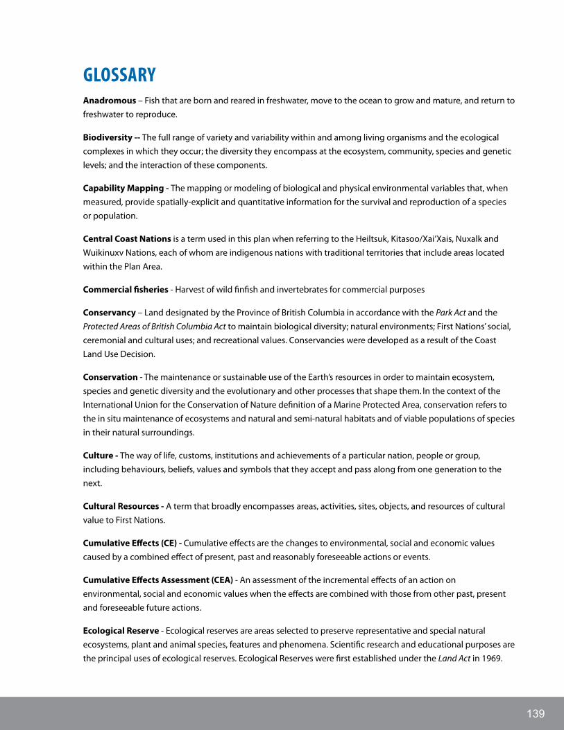
139
gLOSSARyAnadromous – Fish that are born and reared in freshwater, move to the ocean to grow and mature, and return to freshwater to reproduce.
Biodiversity -- The full range of variety and variability within and among living organisms and the ecological complexes in which they occur; the diversity they encompass at the ecosystem, community, species and genetic levels; and the interaction of these components.
Capability Mapping - The mapping or modeling of biological and physical environmental variables that, when measured, provide spatially-explicit and quantitative information for the survival and reproduction of a species or population.
Central Coast Nations is a term used in this plan when referring to the Heiltsuk, Kitasoo/Xai’Xais, Nuxalk and Wuikinuxv Nations, each of whom are indigenous nations with traditional territories that include areas located within the Plan Area.
Commercial fisheries - Harvest of wild finfish and invertebrates for commercial purposes
Conservancy – Land designated by the Province of British Columbia in accordance with the Park Act and the Protected Areas of British Columbia Act to maintain biological diversity; natural environments; First Nations’ social, ceremonial and cultural uses; and recreational values. Conservancies were developed as a result of the Coast Land Use Decision.
Conservation - The maintenance or sustainable use of the Earth’s resources in order to maintain ecosystem, species and genetic diversity and the evolutionary and other processes that shape them. In the context of the International Union for the Conservation of Nature definition of a Marine Protected Area, conservation refers to the in situ maintenance of ecosystems and natural and semi-natural habitats and of viable populations of species in their natural surroundings.
Culture - The way of life, customs, institutions and achievements of a particular nation, people or group, including behaviours, beliefs, values and symbols that they accept and pass along from one generation to the next.
Cultural Resources - A term that broadly encompasses areas, activities, sites, objects, and resources of cultural value to First Nations.
Cumulative Effects (CE) - Cumulative effects are the changes to environmental, social and economic values caused by a combined effect of present, past and reasonably foreseeable actions or events.
Cumulative Effects Assessment (CEA) - An assessment of the incremental effects of an action on environmental, social and economic values when the effects are combined with those from other past, present and foreseeable future actions.
Ecological Reserve - Ecological reserves are areas selected to preserve representative and special natural ecosystems, plant and animal species, features and phenomena. Scientific research and educational purposes are the principal uses of ecological reserves. Ecological Reserves were first established under the Land Act in 1969.

CENTRAL COAST MARINE PLAN140
Ecological Resilience – (1) The ability of a system to undergo, absorb and respond to change and disturbance while maintaining its functions and controls (Carpenter et al. 2001). (2) The amount of change or disturbance that can be absorbed by a system before the system is redefined by a different set of processes and structures.
Ecosystem - A dynamic complex of plant, animal and microorganism communities and their non-living environment interacting as a functional unit.
Ecosystem-based Management (EBM) - Ecosystem-based management is an adaptive approach to managing human activities that seeks to ensure the coexistence of healthy, fully functioning ecosystems and human communities. The intent is to maintain those spatial and temporal characteristics of ecosystems such that component species and ecological processes can be sustained, and human well-being supported and improved.
Ecosystem Component – A fundamental element of the biological, physical or chemical environment which represents an explicit and tangible (i.e., measurable or observable) species, habitat, function, structure or other attribute. Ecosystem components are dynamic and subject to fluctuations and ongoing change. Because most of these changes are not predictable based on available knowledge, they create uncertainty about the future states of the system or its reaction to exploitation and management.
Ecosystem Services - The benefits people obtain from ecosystems, including provisioning services such as food and water; regulating services such as regulation of floods, drought, land degradation, and disease; supporting services such as soil formation and nutrient cycling; and cultural services such as recreational, spiritual, religious and nonmaterial benefits.
Effect - Any response by an environmental or social component to an action’s impact. Under the Canadian Environmental Assessment Act, “environmental effect” means, in respect of a project, “(a) any change that the project may cause in the environment, including any effect of any such change on health and socio-economic conditions, on physical and cultural heritage, on the current use of lands and resources for Traditional purposes by aboriginal persons, or on any structure, site or thing that is of historical, archaeological, paleontological or architectural significance and (b) any change to the project that may be caused by the environment, whether any such change occurs within or outside of Canada”.
Endangered Species - Species that are threatened with immediate extinction or extirpation if the factors threatening them continue to operate. Included are species whose numbers have been reduced to a critical level or whose habitats have been so drastically reduced that they are deemed to be in immediate danger of extinction.
Extirpate – Eliminate a species or subspecies from a particular area, but not from its entire range.
Fisheries Economy - All of the direct and indirect social, cultural and economic benefits derived from current commercial fishing, recreational fishery service providers, recreational fishing and aquaculture. The province and partner First Nations have a vital interest and role in this economy, including fish and seafood processing, distribution, retailing, business development and skills training, disposition of tenures, and maintenance of associated infrastructure.
Foreshore – (1) In the context of tenuring lands in British Columbia, the foreshore is “that land in tidal areas lying between the high tide and the mean low tide and that land in non-tidal areas that is alternatively covered by water and exposed with the normal rise and fall of the level of the body of water, i.e., that land between the
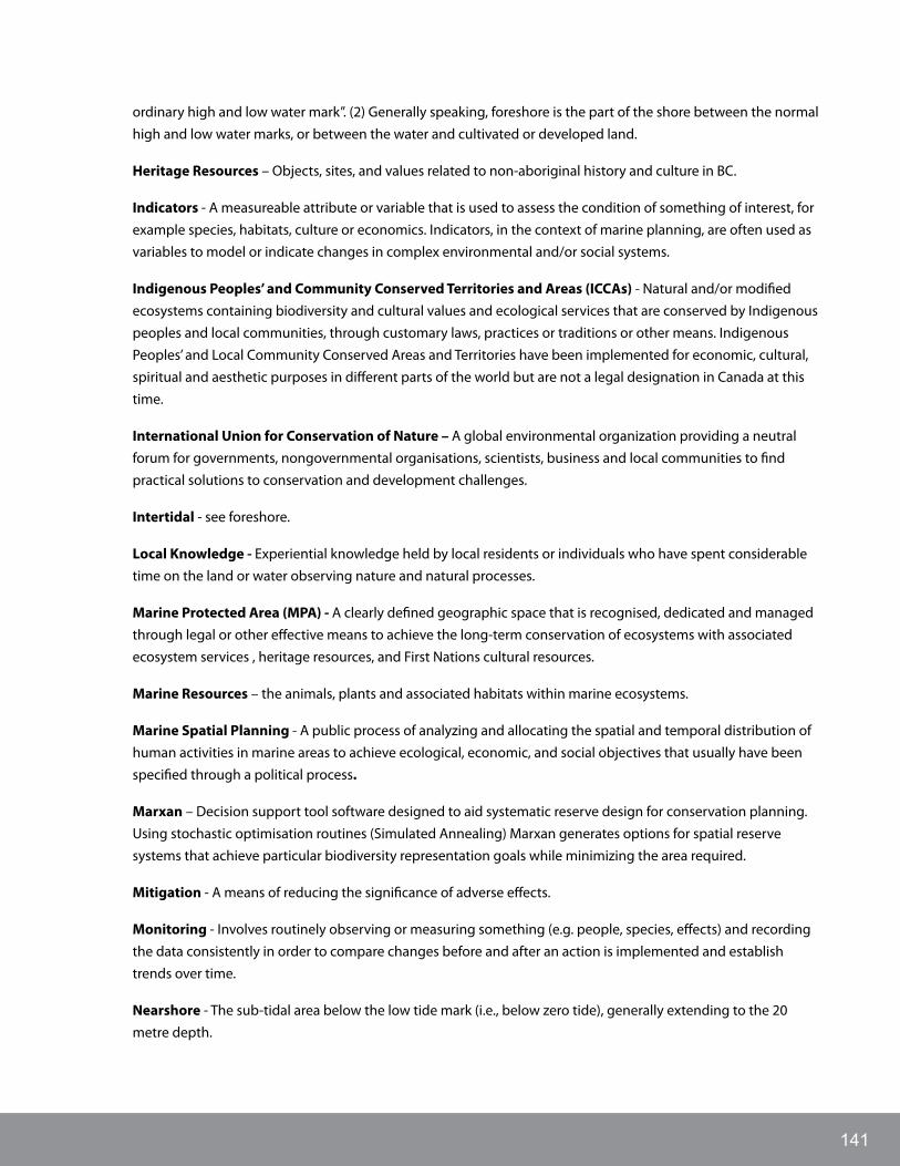
141
ordinary high and low water mark”. (2) Generally speaking, foreshore is the part of the shore between the normal high and low water marks, or between the water and cultivated or developed land.
Heritage Resources – Objects, sites, and values related to non-aboriginal history and culture in BC.
Indicators - A measureable attribute or variable that is used to assess the condition of something of interest, for example species, habitats, culture or economics. Indicators, in the context of marine planning, are often used as variables to model or indicate changes in complex environmental and/or social systems.
Indigenous Peoples’ and Community Conserved Territories and Areas (ICCAs) - Natural and/or modified ecosystems containing biodiversity and cultural values and ecological services that are conserved by Indigenous peoples and local communities, through customary laws, practices or traditions or other means. Indigenous Peoples’ and Local Community Conserved Areas and Territories have been implemented for economic, cultural, spiritual and aesthetic purposes in different parts of the world but are not a legal designation in Canada at this time.
International Union for Conservation of Nature – A global environmental organization providing a neutral forum for governments, nongovernmental organisations, scientists, business and local communities to find practical solutions to conservation and development challenges.
Intertidal - see foreshore.
Local Knowledge - Experiential knowledge held by local residents or individuals who have spent considerable time on the land or water observing nature and natural processes.
Marine Protected Area (MPA) - A clearly defined geographic space that is recognised, dedicated and managed through legal or other effective means to achieve the long-term conservation of ecosystems with associated ecosystem services , heritage resources, and First Nations cultural resources.
Marine Resources – the animals, plants and associated habitats within marine ecosystems.
Marine Spatial Planning - A public process of analyzing and allocating the spatial and temporal distribution of human activities in marine areas to achieve ecological, economic, and social objectives that usually have been specified through a political process.
Marxan – Decision support tool software designed to aid systematic reserve design for conservation planning. Using stochastic optimisation routines (Simulated Annealing) Marxan generates options for spatial reserve systems that achieve particular biodiversity representation goals while minimizing the area required.
Mitigation - A means of reducing the significance of adverse effects.
Monitoring - Involves routinely observing or measuring something (e.g. people, species, effects) and recording the data consistently in order to compare changes before and after an action is implemented and establish trends over time.
Nearshore - The sub-tidal area below the low tide mark (i.e., below zero tide), generally extending to the 20 metre depth.

CENTRAL COAST MARINE PLAN142
Pelagic – Organisms that swim or drift in oceans or open waters, as opposed to those that live in waters adjacent to land or inland. Pelagic organisms include plants, fish and oceanic birds.
Precautionary Principle - The precautionary principle denotes a duty to prevent harm, when it is within our power to do so, even when all evidence is not in. This principle has been codified in several international treaties to which Canada is a signatory.
Recreational Fisheries - Recreational angling, collecting of shellfish, harvesting of finfish and invertebrates by residents and visitors for personal use
Recreational Fishery Service Provider - A person or business engaged in providing services such as a fishing lodge and/or carrying passengers on a charter vessel for the primary purpose of recreational fishing, whenever valuable consideration passes directly or indirectly to the person or business.
Refugia - Habitat that organisms retreat to, persist in or can potentially expand from under changing environmental conditions.
Resilience - see Ecological Resilience
Restoration – The act or process of assisting the recovery and management of damaged ecosystems, restoring internal processes, as well as ecosystem components. Critical to restoration is the identification and control of the cause(s) of ecosystem degradation (British Columbia nd). “Restoration” is considered to broadly encompass a continuum of degrees or stages of restoration and various terms in different statutes and other legal mechanisms, e.g., “restoration”, “rehabilitation”, “remediation”, and “reclamation”.
SARA – Federal Species At Risk Act (S.C. 2002, c. 29).
Seabed - The ground under the sea; the ocean floor.
Shared Decision-making - means a process whereby a First Nation and British Columbia, without changing their respective jurisdictions, rights and responsibilities, agree to engage collaboratively on a specific set of issues, within a specific timeframe, with the goal of seeking an outcome that addresses rather than compromises their respective interests.
Stakeholders - Individuals or groups of people with particular interests in an issue or area. In the ocean management context, stakeholders may include: oil and gas developers, fishermen, subsistence harvesters, hotel owners, port developers, aquaculture farmers, environmental groups, government authorities and others.
Suitability or Suitability Mapping - The mapping or modelling of species or activity viability based on ecological capability combined with social, economic, resource use, infrastructure, marketing and/or cultural values and other parameters.
Sustainable use - Applicable only to renewable resources, and refers to using them at rates within their capacity for renewal. Minerals, oil, gas, and coal are effectively non-renewable and thus cannot be used sustainably. However the length of time that these non-renewable resources are available can be extended by recycling materials, using less of a resource to make a product, and switching to renewable substitutes.
Target – A reference point for an indicator.

143
Temporary port vessel anchorage - That portion of a harbour or area outside a harbour where commercial cargo ships (including oil tankers) are permitted to anchor. Includes but is not limited to permanent anchor mooring. Navigation includes the authorization of cargo ships to temporarily anchor in navigable waterways.
Threshold - A limit of tolerance of a valued ecosystem component (VEC) to an effect that, if exceeded, results in an adverse response by that VEC. The level of magnitude of a system process at which sudden or rapid change occurs. A point or level at which new properties emerge in an ecological, economic or other system, invalidating predictions based on mathematical relationships that apply at lower levels.
Traditional - when used to describe a First Nation’s use, custom, harvest or practice includes historic and modern expressions of that use, custom, harvest or practice, as they evolve and change over time.
Traditional Knowledge - Knowledge gained from generations of living and working within a family, community or culture.
Wildlife Management Area - An area of land designated by the Province of British Columbia under section 4(2) of the Wildlife Act for the benefit of regionally to internationally significant fish and wildlife species or their habitats. Conservation and management of fish, wildlife and their habitats is the priority in a Wildlife Management Area, but other compatible land uses may be accommodated (British Columbia 2013b).
Zoning - The process of designating spatial area(s) using defined geographic coordinates, with each zone type or category having a distinct objective or purpose, description, management recommendation or direction, name and/or identifier.

CENTRAL COAST MARINE PLAN144
REfERENCES
Governance Documents
Coastal First Nations-Great Bear Initiative, North Coast Skeena First Nation Stewardship Society, Nanwakolas Council, Province of British Columbia. 2011. Letter of Intent to collaborate on coastal and marine planning in the Pacific North Coast. Available at http://mappocean.org/wp-content/uploads/2013/10/LOI_Completed_Nov_28_2011-signatures-removed.pdf
Constitution Act, 1867(UK), 30 & 31 Victoria, c 3.
Coastal First Nations and Province of British Columbia. 2009. Coastal First Nations Reconciliation Protocol. Available at http://www2.gov.bc.ca/assets/gov/topic/9EFBD86DA302A0712E6559BDB2C7F9DD/agreements/reconciliation_coastal_haisla_amendment.pdf
Fisheries and Oceans Canada, Coastal First Nations and North Coast – Skeena First Nations Stewardship Society. 2008. Memorandum of Understanding on Pacific North Coast Integrated Management Area Collaborative Oceans Governance and addendums. Addendum to the MOU – Province of British Columbia. 2010. Addendum to the MOU – Nanwakolas Council. Available at http://www.pncima.org/site/document-library/pncima-publications.html
Fisheries and Oceans Canada, Coastal First Nations-Great Bear Initiative and North Coast Skeena First Nations Stewardship Society. 2012. Letter of Intent to collaborate on marine planning and other fisheries related initiatives in the Pacific North Coast.
Province of BC and Heiltsuk First Nation. 2006. Heiltsuk-BC Strategic Land Use Planning Agreement. Available at: http://archive.ilmb.gov.bc.ca/slrp/lrmp/nanaimo/central_north_coast/docs/Heiltsuk_FN_Signed_SLUPA.pdf
Province of BC and Kitasoo/ Xai’Xais First Nation. 2006. Kitasoo/Xai’Xais-BC Strategic Land Use Planning Agreement. Available at: http://archive.ilmb.gov.bc.ca/slrp/lrmp/nanaimo/central_north_coast/docs/Kitasoo_Xaixais_FN_Signed_SLUPA.pdf
Province of BC and Nuxalk First Nation. 2006. Nuxalk-BC Strategic Land Use Planning Agreement. Available at: http://archive.ilmb.gov.bc.ca/slrp/lrmp/nanaimo/central_north_coast/docs/Nuxalk_SLUPA.pdf
Province of BC and Wuikinuxv First Nation. 2006. Wuikinuxv-BC Strategic Land Use Planning Agreement. Available at: http://archive.ilmb.gov.bc.ca/slrp/lrmp/nanaimo/central_north_coast/docs/Wuikinuxv_FN_Signed_SLUPA.pdf
Supreme Court of Canada. 1984. Reference re: Ownership of the Bed of the Strait of Georgia and Related Areas, [1984] 1 S.C.R. 388. Date: 1984-05-17

145
General References
Aboriginal Affairs and Northern Development Canada. 2013. Creating the conditions for economic success on reserve lands - A report on the experiences of 25 First Nation communities (p. 32). Retrieved from http://www.aadnc-aandc.gc.ca/DAM/DAM-INTER-HQ-ECD/STAGING/texte-text/ecd_creating_conditions_1372347251119_eng.pdf
Alley, J., and Topelko, K. 2007. Oceans Governance Arrangements in British Columbia (p. 13).
BC Ministry of Agriculture and Lands (FLNRO). 2008. Order In Council map of marine finfish aquaculture moratorium for tidal waters north of Aristazabal Island. Available from: http://www.for.gov.bc.ca/land_tenures/tenure_programs/programs/aquaculture/documents/OIC_central_northcoast_map.pdf [accessed 22 August 2014].
BC Ministry of Forests, Lands and Natural Resource Operations (FLNRO). 2012. Cumulative effects assessment and management framework. Discussion paper. Unpublished, Victoria, BC.
Day, J., Dudley, N., Hockings, M., Holmes, G., Laffoley, D., Stolton, S., and Wells, S. 2012. Guidelines for applying the IUCN Protected Area Management Categories to Marine Protected Areas. Gland, Switzerland, IUCN, 36 pp.
Ference Weicker & Company Ltd. 2009. Social and Economic Assessment and Analysis of First Nation Communities and Territorial Natural Resources for Integrated Marine Use Planning in the Pacific North Coast Integrated Management Area (p. 111). Vancouver.
Fisheries and Oceans Canada (DFO). 2002. Canada Oceans Strategy: Our Oceans. Our Future, Policy and Operational Framework for Integrated Management of Estuarine, Coastal, and Marine Environments in Canada. DFO, Ottawa, Ontario, Canada.
Foley, M., Halpern, B., Micheli, F., Armsby, M., Caldwell, M., Crain, C., Prahler, E., et al. (2010). Guiding ecological principles for marine spatial planning. Marine Policy, 34(5), 955–966. doi:10.1016/j.marpol.2010.02.001
Government of Canada. (1999). Canadian Environmental Protection Act, 1999. Retrieved from http://laws-lois.justice.gc.ca/eng/acts/c-15.31/page-1.html
Government of Canada. 2011. National Framework for Canada’s Network of Marine Protected Areas. Fisheries and Oceans Canada, Ottawa, ON. 31 pp.
Government of Canada and Government of BC. 2014. Canada-British Columbia Marine Protected Area Network Strategy. Available at http://www.for.gov.bc.ca/tasb/SLRP/pdf/ENG_BC_MPA_LOWRES.pdf
Hegmann, G., Cocklin, C., Creasey, R., Dupuis, S., Kennedy, A., Kingsley, L., Ross, W., et al. (1999). Cumulative Effects Assessment Practitioners Guide (p. 143). Prepared by AXYS Environmental Consulting Ltd. and the CEA Working Group for the Canadian Environmental Assessment Agency, Hull, Quebec
International Union for Conservation of Nature (IUCN). 2008. Guidelines for applying protected area management categories (N. Dudley, ed.). Available at http://www.iucn.org/about/work/programmes/gpap_home/gpap_capacity2/gpap_pub/?1662/1/Guidelines-for-applying-protected-area-management-categories

CENTRAL COAST MARINE PLAN146
Johannessen, D., Harris, K., Macdonald, J., & Ross, P. (2007). Marine Environmental Quality in the North Coast and Queen Charlotte Islands , British Columbia , Canada : A Review of Contaminant Sources , Types , and Risks. Canadian Technical Report of Fisheries and Aquatic Sciences, 2717, 101.
Lucas, B.G., Verrin, S., and Brown, R. (Editors). 2007. Ecosystem overview: Pacific North Coast Integrated Management Area (PNCIMA). Canadian Technical Report of Fisheries and Aquatic Sciences 2667: xiii + 104 p.
Marine Planning Partnership (MaPP) for the North Pacific Coast. 2014a. MaPP Zoning Framework (DRAFT 4.1 August 1 2014)
Marine Planning Partnership (MaPP) for the North Pacific Coast. 2014b. Central Coast Marine Current Conditions and Trends Report.
Marine Planning Partnership (MaPP) for the North Pacific Coast. 2013. MaPP Glossary (DRAFT v2.1 December 27 2013)
Office of the Auditor General of Canada. (2003). 2003 November Report of the Auditor General of Canada - Chapter 9 Economic Development of First Nations Communities: Institutional Arrangements. Retrieved from http://www.oag-bvg.gc.ca/internet/English/parl_oag_200311_09_e_12932.html
Perrin, Thoraut and Associates Ltd. 2009. FIRST NATIONS AND ECONOMIC PROSPERITY IN THE COMING DECADE (p. 31). Retrieved from http://www.bcbc.com/content/550/2020_200909_Perrin.pdf
Robinson Consulting and Associates Ltd. 2012. Socio-economic and Cultural Overview and Assessment Report for the Pacific North Coast Integrated Management Area. Submitted to Fisheries and Oceans Canada.
Uuma Consulting Ltd. 2013. Marine Ecosystem-based Management Indicators for Canada’s Pacific North Coast Region. Phase 1 & 2 draft report.
Spatial Data Sources
British Columbia Marine Conservation Analysis Project Team. 2011. Marine Atlas of Pacific Canada: A Product of the British Columbia Marine Conservation Analysis. Available at www.bcmca.ca.
Clarke, C.L., and Jamieson, G.S. 2006. Identification of ecologically and biologically significant areas in the Pacific North Coast Integrated Management Area: Phase II – Final Report. Canadian Technical Report of Fisheries and Aquatic Sciences 2686: v + 25 p.
Clarke, C.L., and Jamieson, G.S. 2006. Identification of ecologically and biologically significant areas in the Pacific North Coast Integrated Management Area: Phase I – Identification of important areas. Canadian Technical Report of Fisheries and Aquatic Sciences 2678: vi + 89 p.
Fisheries and Oceans Canada (DFO). Amalgamated 4km Grid Commercial Fisheries Catch and Effort Data (various fisheries): geoduck 2003-2009; red sea urchin (RSU) 2000-2008; prawn trap 2001-2009; crab trap 2000-2009; Schedule II including dogfish 1996-2004; shrimp trawl 1996-2004; sablefish longline/trap 1996-2004; ZN (rockfish) licence 1993-2004; halibut 2006-2011 (25km grid).
Fisheries and Oceans Canada (DFO). 2006. Inshore Rockfish Habitat Model.

147
Central Coast Marine Plan Advisory Committee. Meetings occurred from September 2011 to June 2014.
Kenyon, J.K., K. Amey, K. Moore, and M. Dunn. 2007. British Columbia Marine Bird Area of Interest Database, Technical Report Series No. 479. Canadian Wildlife Service, Pacific and Yukon Region, British Columbia.
Pacific North Coast Integrated Management Area Initiative. 2011. Atlas of the Pacific North Coast Integrated Management Area. Available at www.pncima.org
Province of British Columbia, March 2013. Crown Tenures WHSE_TANTALIS.TA_CROWN_TENURES_SVW Available at http://www.for.gov.bc.ca/pScripts/isb/idd/isddmain.asp
Ryder, J.L., J.K. Kenyon, D. Buffett, K. Moore, M. Ceh, and K. Stipec. 2007. An integrated biophysical assessment of estuarine habitats in British Columbia to assist regional conservation planning. Technical Report Series No. 476. Canadian Wildlife Service, Pacific and Yukon Region, British Columbia.
CENTRAL COAST MARINE PLAN148
APPENDICES
A. MPAC Membership, Meeting Dates and Topics
B. MaPP Definitions of Marine Uses and Activities
C. Descriptions of IUCN Categories
D. Potential EBM Indicators
E. Implementation Tools Relevant to the Central Coast Marine Plan

149
APPENDIx A: MPAC MEMbERShIP
Table 56. MPAC membership
Name Sector Role
Warren Warttig Coastal Forestry MPAC Member
Hans Granander Coastal Forestry MPAC Alternate
Kim Olsen Commercial Fisheries MPAC Member
Jim McIsaac Commercial Fisheries MPAC Alternate
Mike Pfortmueller Commercial Rec Fisheries MPAC Member
Sid Keay Commercial Rec Fisheries MPAC Alternate
Evan Loveless Commerical Tourism MPAC Member
Mairi Edgar Commercial Tourism MPAC Alternate
Richard Opala Finfish Aquaculture MPAC Member
Les Neasloss Finfish Aquaculture MPAC Alternate
Brian Lande Local Government MPAC Member
Alison Sayers Local Government MPAC Alternate
Anne Salomon Marine Academic MPAC Member
Diana Chan Marine Conservation MPAC Member
Karin Bodtker Marine Convservation MPAC Alternate
Janice Kyle Public Recreation MPAC Member
Nick Heath Public Recreation MPAC Alternate
Greta Geankoplis Renewable Energy MPAC Member
Gary Wilson Shellfish Aquaculture MPAC Member
Roberta Stevenson Shellfish Aquaculture MPAC Alternate
Table 57. MPAC meeting dates and topics
Dates Topics
Meeting #1
June 26-27, 2012
Introduce MPAC participants, MaPP process and roles; discuss issues and opportunities in the marine environment.
Meeting #2
September 26-27, 2012
Discuss desired future state; develop vision statement; review draft strategies for marine pollution chapter; introduce marine spatial planning.
Meeting #3
December 6-7, 2012
Review desired future state summary report; discuss MPAC mapping exercise; review Current Conditions and Trends for traditional and cultural uses and climate change; review objectives and strategies for marine pollution, climate change, traditional and cultural uses, marine protection, and tourism and recreation.
Meeting #4
January 29-30, 2013
Review Current Conditions and Trends for monitoring and enforcement; review draft objectives and strategies for marine tenures, monitoring and enforcement and marine economy and communities; receive presentations from sectors on the desired future state and spatial interest areas; review draft MaPP Zoning Framework.

CENTRAL COAST MARINE PLAN150
Dates Topics
Meeting #5
March 21-22, 2013
Review draft objectives and strategies for governance; review the marine spatial plan development process; introduce marine spatial planning tools; review primary spatial input layers for marine spatial planning.
Meeting #6
June 25-26, 2013
Review draft High Value Human Use Layers for all sectors; review Marxan cost layer methodology and criteria; review draft compatibility matrix; review Special Management Zone criteria and intent; gain understanding of MaPP Web Mapping tool; participate in field trip.
Meeting #7
September 25-26, 2013
Review, discuss and seek advice on the following emerging products: draft Central Coast Marine Plan, draft Recommended Uses and Activities Tables for Special Management Zones and Protection Management Zones, and draft Vulnerability Matrix; determine how to optimize engagement during spatial plan development process; develop understanding of the review process for the Central Coast Marine Plan.
Meeting #8
November 28-29, 2013
Review, discuss and seek advice on the following emerging products: draft Special Management Zones, draft Protection Management Zones, draft Recommended Uses and Activities Tables for Special Management Zones and Protection Management Zones; jointly plan how to optimize engagement during spatial plan review process; ensure comfort with the tools provided to assist sectors with providing informed advice.
Meeting #9
January 16-17, 2014
Address common questions raised in survey responses; enable discussion related to common concerns about the draft spatial plan; brainstorm proposed revisions to the spatial plan that accommodate the interests of multiple sectors.
Meeting #10
June 17-18, 2014
Summarize how MPAC advice was incorporated into spatial and aspatial components of the draft plan; explain changes to the draft plan that arose from the internal review process; enable discussion related to draft Central Coast Marine Plan; discuss implementation phase.
Meeting #11
October 15-16, 2014
Learn how the Central Coast Marine Plan changed as a result of public and stakeholder feedback; discuss members level of comfort with the current draft of the Central Coast Marine Plan; review Plan priorities and explore stakeholder involvement during implementation; recognize MPAC members’ commitment and contributions to Plan development.

151
APPENDIx b: MAPP DEfINITIONS Of MARINE uSES AND ACTIVITIES
Table 58. MaPP Definitions of Marine Uses and Activities
CategoryMarine Use or Activity
Description
Aquaculture Bottom Aquaculture Siting – Marine Plants, Shellfish, Other Invertebrates
Selection of areas suitable for the cultivation and harvesting of marine plants, shellfish and other invertebrates for commercial purposes. Culture activity occurs on the sea floor and/or between the high water mark and the low water mark in a natural or manufactured environment. Includes associated facilities and infrastructure such as accommodation, rock walls, fencing and anti-predator netting. Note: Also includes associated licensing for plants.
Off-Bottom Aquaculture Siting – Marine Plants, Shellfish, Other invertebrates
Selection of areas suitable for the cultivation and harvesting of marine plants, shellfish and other invertebrates for commercial purposes. Culture activity occurs on the surface or within the water column using grow-out structures such as bags, nets, strings, trays or tubes suspended from longlines or rafts anchored to the seabed. Includes associated facilities and infrastructure. Note: Also includes associated licensing for plants.
Off-Bottom Aquaculture Siting – Finfish
Selection of areas suitable for the cultivation and harvesting of finfish for commercial purposes. Culture activity occurs on the surface or within the water column using net cages anchored to the seabed or closed pens. Includes associated facilities and infrastructure such as anchor blocks, feed barges and sheds, accommodation, navigational markers, net storage and mooring lines.
Energy Renewable Energy Generation
Energy generation from wave, tidal and/or other renewable marine sources as well as offshore wind energy. Includes facilities and infrastructure such as generation structures fixed or anchored to the seabed or foreshore, accommodation, and industrial facilities such as maintenance buildings. Does not include transmission or distribution lines on land or in the sea, which are included under the definition of linear utilities.
Forestry Operations – Log Handling and Storage
Marine operations associated with deposition, sorting, and processing of harvested timber. Includes related facilities and infrastructure, log dumping, log sorts and physical structures such as anchor devices, fill, pilings, permanent ways or ramps and accommodation. Does not include helicopter log drop sites and log transportation.
Forestry Operations – Helicopter Log Drop Sites
Marine operations associated with helicopter log drop sites. Includes related infrastructure such as anchor systems, chains and boomsticks.
Mining Operations Marine operations associated with extracting minerals, including sand and gravel mined from foreshore, nearshore and offshore areas, as well as related facilities and infrastructure. Does not include wharves or docks used for loading and transporting mined products from upland mining operations because these are included under the definition of Level 2 docks.
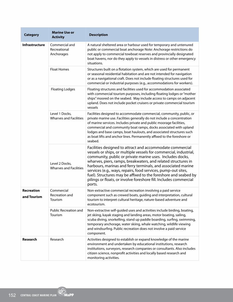
CENTRAL COAST MARINE PLAN152
CategoryMarine Use or Activity
Description
Infrastructure Commercial and Recreational Anchorages
A natural sheltered area or harbour used for temporary and untenured public or commercial boat anchorage Note: Anchorage restrictions do not apply to commercial towboat reserves and provincially designated boat havens, nor do they apply to vessels in distress or other emergency situations.
Float Homes Structures built on a flotation system, which are used for permanent or seasonal residential habitation and are not intended for navigation or as a navigational craft. Does not include floating structures used for commercial or industrial purposes (e.g., accommodations for workers).
Floating Lodges Floating structures and facilities used for accommodation associated with commercial tourism purposes, including floating lodges or “mother ships” moored on the seabed. May include access to camps on adjacent upland. Does not include pocket cruisers or private commercial tourism vessels
Level 1 Docks, Wharves and Facilities
Facilities designed to accommodate commercial, community, public, or private marine use. Facilities generally do not include a concentration of marine services. Includes private and public moorage facilities, commercial and community boat ramps, docks associated with upland lodges and base camps, boat haulouts, and associated structures such as boat lifts and anchor lines. Permanently affixed to the foreshore or seabed.
Level 2 Docks, Wharves and Facilities
Facilities designed to attract and accommodate commercial vessels or ships, or multiple vessels for commercial, industrial, community, public or private marine uses. Includes docks, wharves, piers, ramps, breakwaters, and related structures in harbours, marinas and ferry terminals, and associated marine services (e.g., ways, repairs, food services, pump-out sites, fuel). Structures may be affixed to the foreshore and seabed by pilings or floats, or involve foreshore fill. Includes commercial ports.
Recreation
and Tourism
Commercial Recreation and Tourism
Non-extractive commercial recreation involving a paid service component such as crewed boats, guiding and interpretation, cultural tourism to interpret cultural heritage, nature-based adventure and ecotourism.
Public Recreation and Tourism
Non-extractive self-guided uses and activities include birding, boating, jet skiing, kayak staging and landing areas, motor boating, sailing, scuba diving, snorkelling, stand up paddle boarding, surfing, swimming, temporary anchorage, water skiing, whale watching, wildlife viewing and windsurfing. Public recreation does not involve a paid service component.
Research Research Activities designed to establish or expand knowledge of the marine environment and undertaken by educational institutions, research institutions, surveyors, research companies or consultants. Also includes citizen science, nonprofit activities and locally based research and monitoring activities.
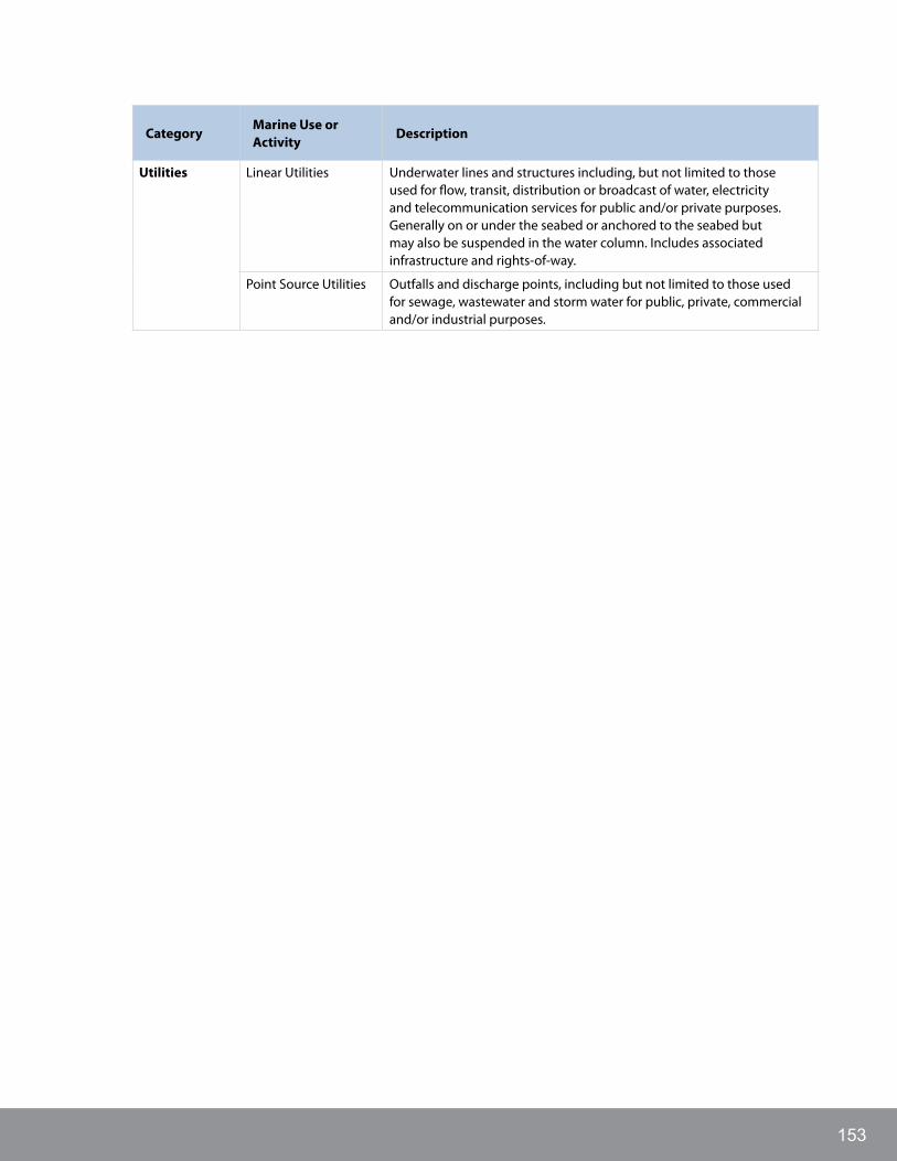
153
CategoryMarine Use or Activity
Description
Utilities Linear Utilities Underwater lines and structures including, but not limited to those used for flow, transit, distribution or broadcast of water, electricity and telecommunication services for public and/or private purposes. Generally on or under the seabed or anchored to the seabed but may also be suspended in the water column. Includes associated infrastructure and rights-of-way.
Point Source Utilities Outfalls and discharge points, including but not limited to those used for sewage, wastewater and storm water for public, private, commercial and/or industrial purposes.

CENTRAL COAST MARINE PLAN154
APPENDIx C: DESCRIPTIONS Of IuCN CATEgORIES
Table 59. Descriptions of IUCN categories
IUCN Category
Description
Ia Strictly protected areas set aside to protect biodiversity and also possibly ecological/geomorphological features, where human visitation, use and impacts are strictly controlled and limited to ensure protection of the conservation values. Such protected areas can serve as indispensable reference areas for scientific research and monitoring.
Ib Usually large unmodified or slightly modified areas, retaining their natural character and influence, without permanent or significant human habitation, which are protected and managed so as to preserve their natural condition
II Large natural or near natural areas set aside to protect large-scale ecological processes, along with the complement of species and ecosystems characteristics of the area, which also provide a foundation for environmentally and culturally compatible spiritual, scientific, educational, recreational and visitor opportunities
III Set aside to protect a specific natural monument, which can be a landform, sea mount, submarine cavern, geological feature such as a cave or even a living component such as a specific coralline feature. They are generally quite small protected areas and often have high visitor value.
IV Aim to protect particular species or habitats and management reflects this priority. Many category IV protected areas will need regular, active interventions to address the requirements of particular species or to maintain habitats, but this is not a requirement of the category.
V Areas where the interaction of people and nature over time has produced an area of distinct character with significant ecological, biological, cultural and scenic value: and where safeguarding the integrity of this interaction is vital to protecting and sustaining the area and its associated nature conservation and other values.
VI Areas that conserve ecosystems and habitats, together with associated cultural values and traditional natural resource management systems. They are generally large, with most of the area in a natural condition, where a proportion is under low-level non-industrial sustainable natural resource management and where such use of natural resources compatible with nature conservation is seen as one of the main aims of the area.

155
APPENDIx D: POTENTIAL EbM INDICATORSThe following preliminary EBM indicators may be used throughout the MaPP study area and were identified based on the following criterion:
a) Alignment with MaPP strategies
b) Connectivity/ relevance across habitat types and with human well-being
c) Practicality and existing monitoring.
Additional indicators specific to the Central Coast may be selected during implementation.
Table 60. Potential EBM Indicators
Ecological Indicators
Ecological components Recommended indicators
Habitat Quality Measure of functional estuarine habitat
*additional indicators of all habitats will be identified
Community composition Change in community composition
Trophic dynamics Not recommended at this time
Key species and communities
Birds Shorebird abundance during spring/fall stopover
Population size of breeding seabirds
Bivalves Mussels
Cetaceans Habitat use by marine mammals
Coastal riparian vegetation Extent of intact coastal riparian vegetation
Corals and sponge reefs Not recommended at this time
Crustaceans Abundance and size of key crustacean species
Echinoderms Urchin abundance and distribution
Eelgrass Eelgrass distribution and biomass
Forage Fish Forage fish community composition
Herring spawn distribution and biomass
Groundfish Benthic fish community composition
Introduced / invasive species Invasive / non-native species distribution and abundance
Invertebrates Benthic macro-invertebrate species community composition
Jellyfish Not recommended at this time
Kelp forests Kelp forest canopy cover
Macroalgae Not recommended at this time
Pacific Salmon Salmon abundance and distribution of adults by species
Pelagic fish Not recommended at this time
Phytoplankton Chlorophyll-a from satellite and/or in situ surveys
Sea otters Sea otter presence / abundance

CENTRAL COAST MARINE PLAN156
Ecological components Recommended indicators
Seal Seal abundance
Zooplankton Not recommended at this time
Environmental states and drivers
Recommended indicators
Atmospheric forcing Climate indices
Wind speed and direction
Chemical oceanography Dissolved carbon dioxide
Dissolved oxygen
Nutrient concentrations
Ocean pH
Physical oceanography Sea surface temperature
Ocean salinity
Sea level Sea level height
Sediment processes Suspended sediments
Storms and waves Frequency and intensity of storms
Watershed conditions Freshwater runoff (sediment, volume, timing and temperature)
Wind driven upwelling/downwelling
Not recommended at this time (redundant with wind)
Human Pressures Recommended indicators
Aquaculture Number, size, location and type of finfish and shellfish aquaculture farms in BC
Coastal development Coastal population density
Shoreline armoring
Square kilometers of forestry, agriculture, urban land cover
Fisheries and fisheries management
Number of pacific salmon released from hatcheries
Habitat modification Habitat destructed by fishing
Coral and sponges occurrences in trawl observer data
Seafloor alteration via dredging, drilling, dumping and/or construction
Ocean noise Anthropogenic ocean noise at specific locations
Oil spills Number, location and extent of coastal oil pollution events
Pollution and contamination Water quality (turbidity, pollution, nutrient enrichment)
Area of sediment with contaminant levels above SQ guidelines
Shifts in point sources of pollution
Sedimentation and turbidity Not recommended at this time (redundant with monitoring driver sediment processes)
Shipping and boating Footprint of commercial and recreational boats

157
Human Well-being Indicators
Institutional Indicators
Institutional Follow-through: Administration
1. Proportion of performance measures in the service plans of relevant government departments or agencies that are: not achieved, partially achieved, achieved, exceeded.
2. Changes in marine management service levels by government departments (by survey of managers) where budgets are stable or declining.
3. Changes in costs of marine management tracked over time (from MRAG, 2013): a) changes in government costs (budgets): Federal, First Nations, Provincial, Local; b) changes in management costs incurred by sectors.
Institutional Management and Follow-through: Assessment
1. Percentage of region with current/active community, sub-regional, regional assessments for: socio-economic, ecosystem, cultural, and climate change risks and vulnerabilities. Number of assessments that incorporate cumulative effects. See 9 below.
2. Number of assessment strategies in place in the region that involve collaboration in a) information sharing and b) monitoring efforts among governments, Nations, agencies, research institutes, ENGOs (see also Administration)
Institutional Management and Follow-through: Programs
1. Proportion of performance measures of relevant government departments or agencies that are: not achieved, partially achieved, achieved, for the following programs:
» Climate change
» Emergency response
» Sustainable Tourism
» Sustainable economic development
» Mitigation of human impacts on ecosystems
» Restoration and protection of ecosystems
» Infrastructure development
» Transmission of cultural knowledge, preservation of cultural identities
» Monitoring and surveillance
2. Changes in service levels by government departments where budgets are stable or declining for the above programs.
3. Changes in costs of program management for the previously listed programs tracked over time: a) changes in government costs (budgets): Federal, First Nations, Provincial, Local; b) changes in management costs incurred by sectors.
Institutional Authority: Regulations and Compliance
1. Compliance: Number of warnings, citations or infractions issued for non-compliance per resource use activity or sector (Merritt 2013)
Institutional Authority: Plans and Policy
1. Percentage of plans and legislative policies relevant to the planning area that incorporate and demonstrate commitment to adaptive management
2. Percentage of Plans for the MaPP region or sub-regions that a) use measures or targets that allow for performance assessment and b) are being met, nearly met, or exceeded.

CENTRAL COAST MARINE PLAN158
Institutional Authority: Formal Agreements: Protocols, Agreements, and Legislation
1. Percentage of total pieces of formal agreements (legislation, by-laws, agreements, MOEs, protocols, treaties) that have performance measures that assess a) their level of implementation; and b) their effectiveness at achieving their objectives
Political Wellbeing: Governance Relationships
1. Representation: Indicator 1: Representation—Percentage of collaborative planning bodies with complete/near complete representation and participation of relevant governments/ agencies. (MaPP Human Wellbeing and Governance Indicators Workshop 1, 2)
2. Collaboration Index: 1) Number of government to government agreements (percentage of area covered by government to government agreements (Sheltair group, 2006, 2008); 2) Number of active treaty disputes; 3) Number of inter-measures agreements or other pre-treaty agreements; 4) Number of court cases regarding aboriginal rights and title (MaPP Human Wellbeing and Governance Indicators Workshop 2)
Political Wellbeing: Leadership and Participation
1. Engagement: % of management processes using the following engagement mechanisms: a) delegated management bodies; b) shared/joint/co-management; c) regular advisory bodies; d) periodic consultative sessions; e) information sharing events and mechanisms (websites, conferences, etc); f ) no engagement. (MaPP Human Wellbeing and Governance Indicators Workshop 2)
2. Quality of Leadership: Satisfaction survey in relation to quality of leadership in local governance and marine management (empowering others, balancing opportunities and risks, vision, coming to solutions, managing conflict) (MaPP Human Wellbeing and Governance Indicators Workshop 1)
Social Indicators
Community Wellbeing: Human Connections to Place and Environment
1. Non-market Connections: Number of residents engaged in self-provisioning, and number and type of species used in self-provisioning (MaPP Human Well-being and Governance Indicators Workshop 1 2013)
2. Market Connections: Number of active (at least one landing a year) fishing boats and number of boat trips per year (Merritt 2013)
Cultural Continuity
1. Valuing Culture: Self-assessed value (high, medium, low) placed on the following: Speaking a Traditional language; practicing Traditional skills (harvesting, arts); being part of Traditional cultural events and ceremonies; incorporating Traditional practices, manners, and protocols at public events or political processes (adapted from Ura et al. 2012).
2. Language: a) Number of speakers fluent in Traditional languages per Nation (Sheltair Group 2006, Rubus EcoScience Alliance 2007, Merritt 2013) and b) Number of local residents participating in Traditional language education (including demographic of participants: age, gender, ethnicity).
Knowledge and Education
1. Educational Attainment: Mean years of schooling, expectant years of schooling per region (HDI) or b) Percentage of population (25-54 yeas) without high-school and post-secondary certification by school district or health authority (BCStats, 2013)
2. Local Training to Employment: Number of local training programs and employment placement rates after graduation from the programs (from Sheltair 2006, Loucks and Day, 2011, MaPP Human Well-being and Governance Indicators Workshops 1, 2)

159
3. Integrated Knowledge: (see also Assessment)
» % of marine management processes regularly using knowledge from the following sources when making decisions or plans: a) agency; b) other agencies or governments; c) First Nations; d) users; e) non-profits); f ) community/local; g) academic.
» % of marine management processes regularly using knowledge from the following disciplines to formulate decisions or plans: a) biological/ecological; b) social; c) economic; d) cultural.
» % of marine management processes regularly using knowledge beyond a species or subject being directly managed: a) cumulative effects; b) ecosystem services; c) broader social consequences; d) broader economic consequences.
Personal Wellbeing: Physical, Mental, and Spiritual Health
1. Physical Health: Life expectancy at birth per region (HDI, 2012)
2. Emotional/Spiritual Health:
» Self-assessed level of personal trauma experienced (by survey): Residential School; Major economic hardship; Personal traumatic event
» Self-assessment of support levels: community support services, information about coping strategies, peer support, family support
» Self-assessment of level of life satisfaction: How would you rate your present life situation, how do you see your life prospects. Rate on a scale of 1 to 10 (Gallup 2012)
Population/ Demographics
1. Demographics: Annual percent change in population size per community, including total population, age, gender, and ethnic composition (from Merritt, 2013), Watson 2013)
Work: Employment
1. Participation: Rates of employment and unemployment and/or participation per sub-region or community and by occupation or industry (Clayoquot Biosphere Trust 2010; Fraser Basin Council 2010; BCStats, 2013; Watson 2013).
Work: Job Satisfaction
1. Self-assessed job satisfaction ratings in marine-related sectors.
Economic Indicators
Work—Labour Market: Local Labour Capacity
Number and percentage of workers in the Plan Area who:
1. Are permanent residents (of community or area) - First Nations and non-First Nations
2. Are temporary workers/residents
3. Commute from a home community
Financial Capacity— Distribution of Wealth: Income Disparity
1. Number of income earners in the lower two income brackets (less than $15,000, and $15,000 to $24,999 annually) as a percentage of higher income earners for the Plan Area ($35,000+ and $50,000+ categories)
Financial Capacity—Distribution of Wealth: Regional Wealth
Wealth as indicated by either:
1. Gross regional income per capita
2. Family income: Median household income per sub-region

CENTRAL COAST MARINE PLAN160
Financial Capacity: Local Investment
1. Local Investment, consisting of:
» Rate of marine related infrastructure development (number of new developments and cost scale).
» Number of new local businesses, business incorporations
» Commercial loan levels (dollars per Plan Area) (Rubus EcoScience Alliance, 2007)
» Level of third party investment in social capital (ex. grant funding) and proportion of investment from different sources (private financial; institutions; government; foundation)
» Percentage of resource revenues per sector directed to support: local community based programs or infrastructure, resource stewardship
Economic Structures and Systems: Diversity and Interdependence
1. Employment per sector per region and sub-region
Economic Structures and Systems—Resilience and Sustainability: Age of businesses and local ownership
1. Indicator 1: Ratio of businesses that have existed under and over 7 years
2. Indicator 2: Percentage of businesses operating in the region that are owned locally
Economic Access—Resource Access and Allocation: Local Access
1. Number and ratio of commercial and recreational licenses and tenures held:
» Locally and non-locally
» By First Nations and Non-First Nations by sector (including: fisheries, aquaculture, adventure tourism/commercial recreation, mineral exploration, energy production, and other natural resource tenures).
2. Tenure application process: 1) How many new tenure applications have been made in a time period; b) What type of economic activity; b) how long has it taken to process; c) ratio of acceptance to rejection; d) if rejected, why?; e) if accepted, was there significant opposition and from whom?
Economic Access—Market Access: Local Access
1. Number and percentage of a) locally produced marine related goods and services, and, b) locally produced value-added marine related goods and services, that are traded:
» Locally or regionally
» In Canada
» Internationally
Productivity—Costs and Barriers: Yearly Costs, Net Profit/Loss, % of business profitable vs. non-profitable (per Sector)
1. Average yearly costs (per sector) as measured by:
» Costs of sales (direct expenses, broken down)
» Operating expenses (indirect expenses, broken down)
2. Net Profit/Loss
3. % of businesses profitable vs. non-profitable
Productivity—Economic Output: Primary Economic Output
Primary economic output per marine sector by volume and value
Productivity—Growth: Business Licenses
1. Number of business licences, including:
» The number of business licenses issued each year
» The number of new business licences issued each year
» The number of new business incorporations and partnerships in the region registered annually
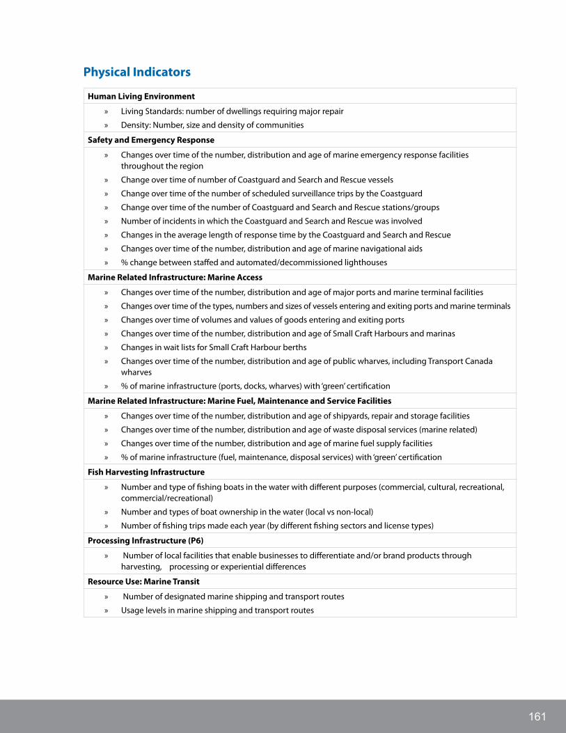
161
Physical Indicators
Human Living Environment
» Living Standards: number of dwellings requiring major repair
» Density: Number, size and density of communities
Safety and Emergency Response
» Changes over time of the number, distribution and age of marine emergency response facilities throughout the region
» Change over time of number of Coastguard and Search and Rescue vessels
» Change over time of the number of scheduled surveillance trips by the Coastguard
» Change over time of the number of Coastguard and Search and Rescue stations/groups
» Number of incidents in which the Coastguard and Search and Rescue was involved
» Changes in the average length of response time by the Coastguard and Search and Rescue
» Changes over time of the number, distribution and age of marine navigational aids
» % change between staffed and automated/decommissioned lighthouses
Marine Related Infrastructure: Marine Access
» Changes over time of the number, distribution and age of major ports and marine terminal facilities
» Changes over time of the types, numbers and sizes of vessels entering and exiting ports and marine terminals
» Changes over time of volumes and values of goods entering and exiting ports
» Changes over time of the number, distribution and age of Small Craft Harbours and marinas
» Changes in wait lists for Small Craft Harbour berths
» Changes over time of the number, distribution and age of public wharves, including Transport Canada wharves
» % of marine infrastructure (ports, docks, wharves) with ‘green’ certification
Marine Related Infrastructure: Marine Fuel, Maintenance and Service Facilities
» Changes over time of the number, distribution and age of shipyards, repair and storage facilities
» Changes over time of the number, distribution and age of waste disposal services (marine related)
» Changes over time of the number, distribution and age of marine fuel supply facilities
» % of marine infrastructure (fuel, maintenance, disposal services) with ‘green’ certification
Fish Harvesting Infrastructure
» Number and type of fishing boats in the water with different purposes (commercial, cultural, recreational, commercial/recreational)
» Number and types of boat ownership in the water (local vs non-local)
» Number of fishing trips made each year (by different fishing sectors and license types)
Processing Infrastructure (P6)
» Number of local facilities that enable businesses to differentiate and/or brand products through harvesting, processing or experiential differences
Resource Use: Marine Transit
» Number of designated marine shipping and transport routes
» Usage levels in marine shipping and transport routes

CENTRAL COAST MARINE PLAN162
Resource Use: Seafood: Wild and Farmed
» Fishing Effort
» Proportion of Total Allowable Catch that is caught
» Number of days per year that fisheries are open
Seafood Sustainability Index including:
» Total current seafood production from Plan Area
» Regional seafood landings
» Regional seafood processing
» Regional consumption of seafood
» Export of seafood landed in the region
» Fish populations status, by species
» % of Plan Area with economically viable commercial fisheries potential that is closed
» Number of past or potential commercial fisheries that are closed
» Top five reasons for areas or fisheries being closed or inactive
» % of Plan Area with economically viable aquaculture potential
» % of Plan Area designated in plans for aquaculture production
» % of designated areas with active aquaculture production
» % of designated areas in de-commissioning or unutilized
» Top five reasons for designated aquaculture areas not being utilized for aquaculture
» Evaluation of pollution levels and safety of relevant species for human consumption
» Habitat impact levels from aquaculture
» Levels of aquaculture-derived pharmaceuticals in fresh and salt water ecosystems
» Disease and parasite interactions between wild enhanced and aquaculture
» Fishery methods: seafloor disturbances
» Discard of catch at sea, including estimated mortality levels
Resource Conservation (P9/In4)
» Percentage of Plan Area designated with official protected area status
Resource Use: Designation of Space (In5/P10/E2)
» Changes in time of percentage of Plan Area designated for specific uses
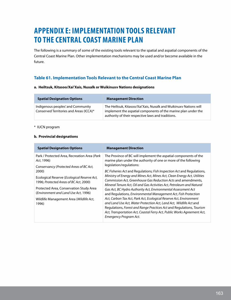
163
APPENDIx E: IMPLEMENTATION TOOLS RELEVANT TO ThE CENTRAL COAST MARINE PLANThe following is a summary of some of the existing tools relevant to the spatial and aspatial components of the Central Coast Marine Plan. Other implementation mechanisms may be used and/or become available in the future.
Table 61. Implementation Tools Relevant to the Central Coast Marine Plan
a. Heiltsuk, Kitasoo/Xai’Xais, Nuxalk or Wuikinuxv Nations designations
Spatial Designation Options Management Direction
Indigenous peoples’ and Community Conserved Territories and Areas (ICCA)*
The Heiltsuk, Kitasoo/Xai’Xais, Nuxalk and Wuikinuxv Nations will implement the aspatial components of the marine plan under the authority of their respective laws and traditions.
* IUCN program
b. Provincial designations
Spatial Designation Options Management Direction
Park / Protected Area, Recreation Area (Park Act, 1996)
Conservancy (Protected Areas of BC Act, 2000)
Ecological Reserve (Ecological Reserve Act, 1996; Protected Areas of BC Act, 2000)
Protected Area, Conservation Study Area (Environment and Land Use Act, 1996)
Wildlife Management Area (Wildlife Act, 1996)
The Province of BC will implement the aspatial components of the marine plan under the authority of one or more of the following legislation/regulations:
BC Fisheries Act and Regulations; Fish Inspection Act and Regulations, Ministry of Energy and Mines Act, Mines Act, Clean Energy Act, Utilities Commission Act, Greenhouse Gas Reduction Acts and amendments, Mineral Tenure Act, Oil and Gas Activities Act, Petroleum and Natural Gas Act, BC Hydro Authority Act, Environmental Assessment Act and Regulations, Environmental Management Act, Fish Protection Act, Carbon Tax Act, Park Act, Ecological Reserve Act, Environment and Land Use Act, Water Protection Act, Land Act, Wildlife Act and Regulations, Forest and Range Practices Act and Regulations, Tourism Act, Transportation Act, Coastal Ferry Act, Public Works Agreement Act, Emergency Program Act.

CENTRAL COAST MARINE PLAN164
c. Federal designations
All spatial recommendations in the Central Coast Marine Plan provide policy guidance intended to inform the decision making processes regarding uses and activities in the areas identified. The appropriate policy and legal instruments for achieving stated PMZ objectives will be determined during plan implementation. The following is adapted from the draft PNCIMA plan and lists federal designations and legislation/regulation that may be relevant to the spatial and aspatial aspects of the Central Coast Marine Plan in the future.
Spatial Designation Options Management Direction
Marine Protected Area (Oceans Act, 1996)
National Marine Conservation Area (Canada National Marine Conservation Areas Act, 2002)
National Park (marine component) (Canada National Parks Act, 2000)
National Wildlife Area (Canada Wildlife Act, 1985)
Migratory Bird Sanctuary (Migratory Birds Convention Act, 1994)
The following are key pieces of federal legislation that may have a role in the aspatial implementation of the Central Coast Marine Plan:
Department of Indian Affairs and Northern Development Act, Indian Act, First Nations Fiscal and Statistical Management Act, First Nations Jurisdiction Over Education in British Columbia Act, First Nations Land Management Act, Oceans Act, Canada Shipping Act and Regulations, Canadian Environmental Assessment Act, Cultural Property Export and Import Act, Migratory Birds Convention Act, Canada Wildlife Act, Species at Risk Act, Canadian Environmental Protection Act, Fisheries Act and Regulations, Coastal Fisheries Protection Act, Fisheries Development Act, Department of Fisheries and Oceans Act, Fishing and Recreational Harbours Act, Telecommunications Act, National Defence Act, Canada Petroleum Resources Act, Department of Natural Resources Act, Resources and Technical Surveys Act, Canada Oil and Gas Operations Act, Canada Transportation Act, National Energy Board Act, Canada National Marine Conservation Areas Act, Canada National Parks Act and Regulations, Navigable Waters Protection Act, Pilotage Act, Canada Marine Act, Marine Transportation and Security Act, Marine Liability Act, Transportation of Dangerous Goods Act, International Conventions (including Convention on the Prevention of Marine Pollution by Dumping of Wastes and Other Matter, Convention for the Prevention of Pollution from Ships, United Nations Convention on Law of the Sea)

165

NuxalkNation
WuikinuxvNation
HeiltsukNation
Kitasoo/Xai’Xais Nation
whERE TO gO fOR MORE INfORMATIONThe Marine Planning Partnership: http://mappocean.org/
MaPP’s Marine Planning Portal (using the Seasketch application): http://www.seasketch.org/projects/