Embed Size (px)
Citation preview
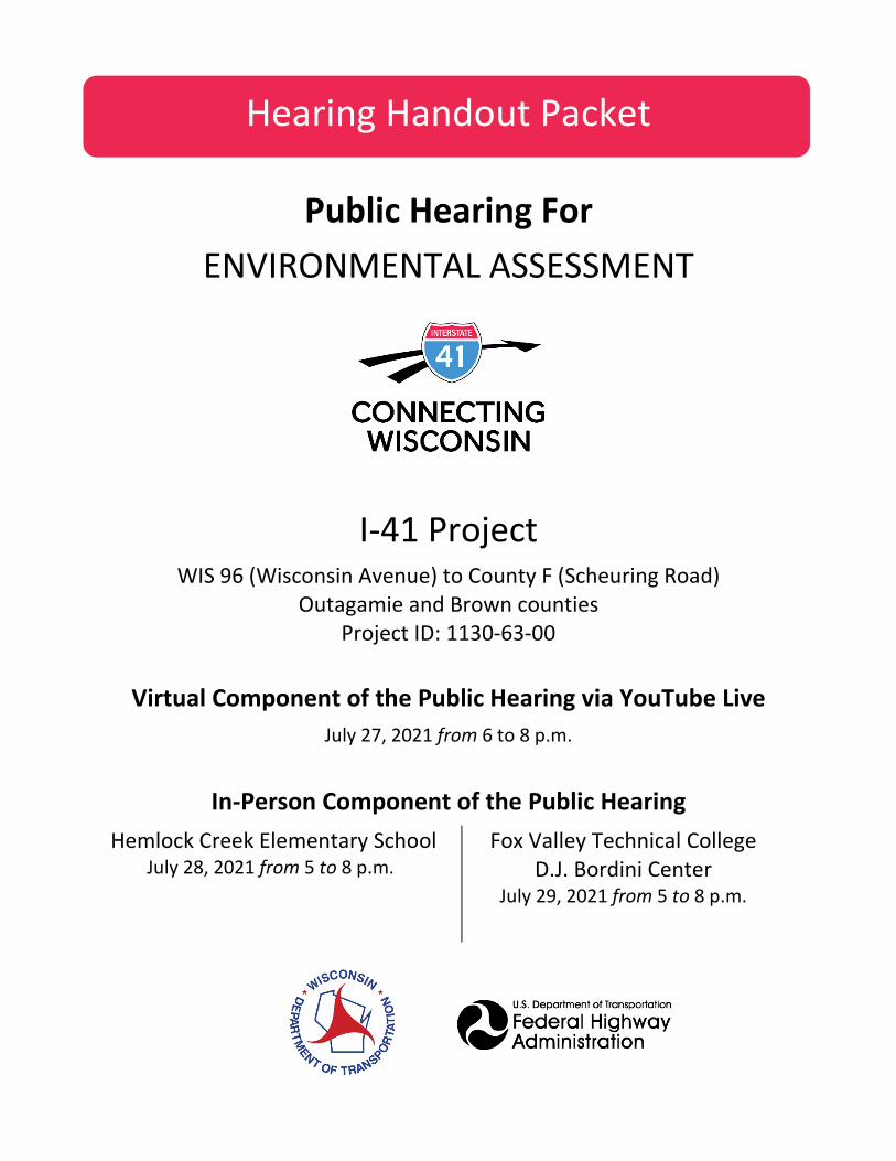
Hearing Handout Packet
Public Hearing For ENVIRONMENTAL ASSESSMENT
I-41 Project WIS 96 (Wisconsin Avenue) to County F (Scheuring Road)
Outagamie and Brown counties Project ID: 1130-63-00
Virtual Component of the Public Hearing via YouTube Live July 27, 2021 from 6 to 8 p.m.
In-Person Component of the Public Hearing Hemlock Creek Elementary School
July 28, 2021 from 5 to 8 p.m.
Fox Valley Technical College D.J. Bordini Center
July 29, 2021 from 5 to 8 p.m.
Handout Packet Contents WELCOME ........................................................................................................................................................................ 3
PUBLIC HEARING AGENDA ............................................................................................................................................... 3
OPTIONS AND INSTRUCTIONS FOR PROVIDING TESTIMONY ............................................................................................ 5
PROJECT/STUDY LOCATION MAP ..................................................................................................................................... 8
PURPOSE OF THE PUBLIC HEARING .................................................................................................................................. 8
ENVIRONMENTAL DOCUMENT PROCESS .......................................................................................................................... 9
INFORMATION FOR THE PUBLIC HEARING RECORD ........................................................................................................10
PROJECT STATEMENT ......................................................................................................................................................10
ALTERNATIVES COMPARISON MATRIX ............................................................................................................................22
NOISE BARRIERS ..............................................................................................................................................................23
SECTION 4(F) IMPACTS ....................................................................................................................................................23
PROPERTY ACQUISITION/RELOCATION ASSISTANCE AND BENEFITS................................................................................24
NEXT STEPS .....................................................................................................................................................................25
DESCRIPTION OF PUBLIC HEARING EXHIBITS ...................................................................................................................26
POWERPOINT PRESENTATION .........................................................................................................................................27
CONTACT INFORMATION ................................................................................................................................................28
ENVIRONMENTAL ASSESSMENT EXHIBITS .......................................................................................................................29
WRITTEN TESTIMONY FORM ...........................................................................................................................................39
REGISTRATION SLIP FOR VERBAL TESTIMONY .................................................................................................................41
I-41 Project - Public Hearing Page 3
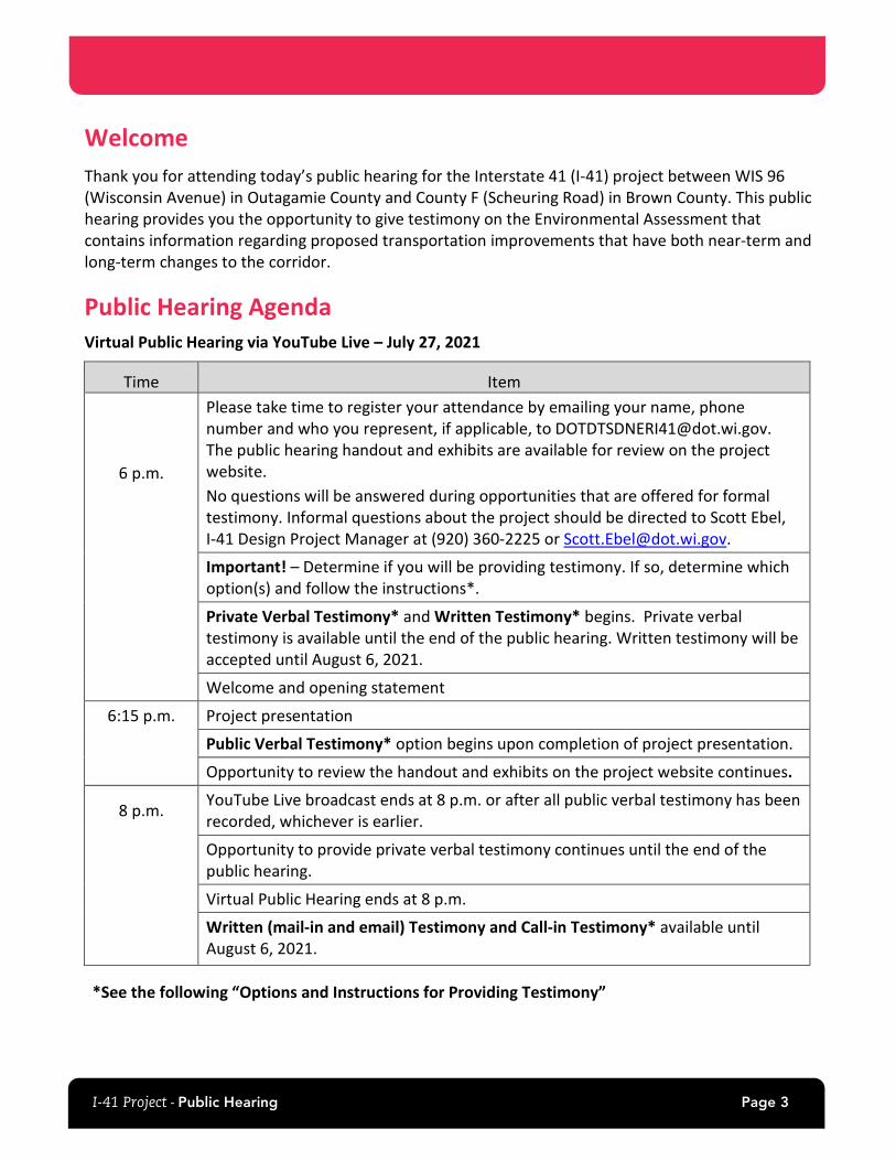
Welcome Thank you for attending today’s public hearing for the Interstate 41 (I-41) project between WIS 96 (Wisconsin Avenue) in Outagamie County and County F (Scheuring Road) in Brown County. This public hearing provides you the opportunity to give testimony on the Environmental Assessment that contains information regarding proposed transportation improvements that have both near-term and long-term changes to the corridor.
Public Hearing Agenda Virtual Public Hearing via YouTube Live – July 27, 2021
Time Item
6 p.m.
Please take time to register your attendance by emailing your name, phone number and who you represent, if applicable, to [email protected]. The public hearing handout and exhibits are available for review on the project website. No questions will be answered during opportunities that are offered for formal testimony. Informal questions about the project should be directed to Scott Ebel, I-41 Design Project Manager at (920) 360-2225 or [email protected].
Important! – Determine if you will be providing testimony. If so, determine which option(s) and follow the instructions*.
Private Verbal Testimony* and Written Testimony* begins. Private verbal testimony is available until the end of the public hearing. Written testimony will be accepted until August 6, 2021.
Welcome and opening statement
6:15 p.m. Project presentation
Public Verbal Testimony* option begins upon completion of project presentation.
Opportunity to review the handout and exhibits on the project website continues.
8 p.m. YouTube Live broadcast ends at 8 p.m. or after all public verbal testimony has been recorded, whichever is earlier.
Opportunity to provide private verbal testimony continues until the end of the public hearing.
Virtual Public Hearing ends at 8 p.m.
Written (mail-in and email) Testimony and Call-in Testimony* available until August 6, 2021.
*See the following “Options and Instructions for Providing Testimony”

I-41 Project - Public Hearing Page 4
In Person Public Hearing – July 28 and July 29, 2021
Time Item
5 p.m. Sign in, pick up handout, review exhibits, visit with project staff and ask questions about the proposed improvements.
Important! – Determine if you will be providing testimony. If so, determine which option(s) and follow the instructions*.
Availability to provide Public Verbal Testimony*, Private Verbal Testimony* and Written Testimony* begins. These options are available until the end of the public hearing. Written testimony will be accepted until August 6, 2021.
Opening statement, information for the record, and project statement read.
Continuous looping project presentation.
8 p.m. In-Person Public Hearing ends.
Written (mail-in and email) Testimony and Call-in Testimony*available until August 6, 2021.
*See the following “Options and Instructions for Providing Testimony”
I-41 Project - Public Hearing Page 5
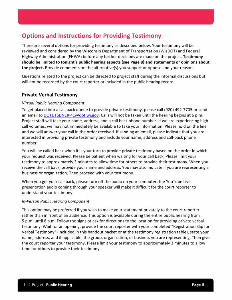
Options and Instructions for Providing Testimony There are several options for providing testimony as described below. Your testimony will be reviewed and considered by the Wisconsin Department of Transportation (WisDOT) and Federal Highway Administration (FHWA) before any further decisions are made on the project. Testimony should be limited to tonight’s public hearing aspects (see Page 8) and statements or opinions about the project. Provide comments on the alternative(s) you support or oppose and your reasons.
Questions related to the project can be directed to project staff during the informal discussions but will not be recorded by the court reporter or included in the public hearing record.
Private Verbal Testimony Virtual Public Hearing Component To get placed into a call back queue to provide private testimony, please call (920) 492-7705 or send an email to [email protected]. Calls will not be taken until the hearing begins at 6 p.m. Project staff will take your name, address, and a call back phone number. If we are experiencing high call volumes, we may not immediately be available to take your information. Please hold on the line and we will answer your call in the order received. If sending an email, please indicate that you are interested in providing private testimony and include your name, address and call-back phone number.
You will be called back when it is your turn to provide private testimony based on the order in which your request was received. Please be patient when waiting for your call back. Please limit your testimony to approximately 3 minutes to allow time for others to provide their testimony. When you receive the call back, provide your name and address. You may also indicate if you are representing a business or organization. Then proceed with your testimony.
When you get your call back, please turn off the audio on your computer; the YouTube Live presentation audio coming through your speaker will make it difficult for the court reporter to understand your testimony.
In-Person Public Hearing Component
This option may be preferred if you wish to make your statement privately to the court reporter rather than in front of an audience. This option is available during the entire public hearing from 5 p.m. until 8 p.m. Follow the signs or ask for directions to the location for providing private verbal testimony. Wait for an opening, provide the court reporter with your completed “Registration Slip for Verbal Testimony” (included in this handout packet or at the testimony registration table), state your name, address, and if applicable, the group, organization, or business you are representing. Then give the court reporter your testimony. Please limit your testimony to approximately 3 minutes to allow time for others to provide their testimony.
I-41 Project - Public Hearing Page 6
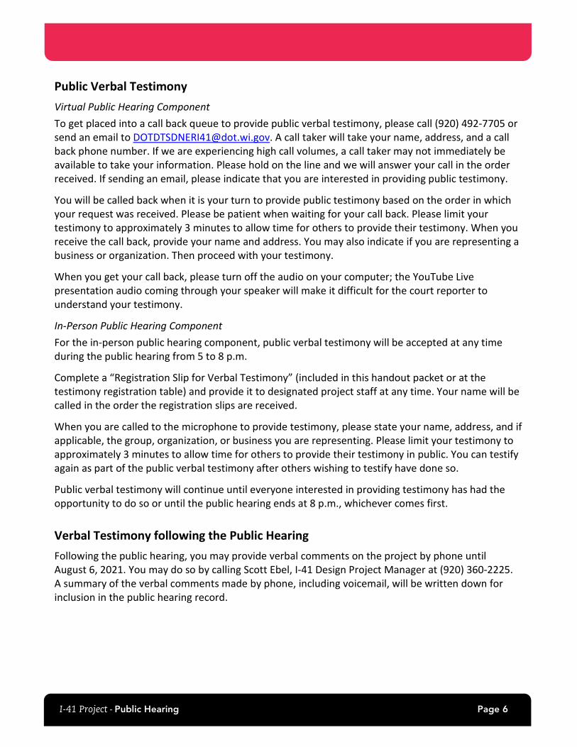
Public Verbal Testimony Virtual Public Hearing Component To get placed into a call back queue to provide public verbal testimony, please call (920) 492-7705 or send an email to [email protected]. A call taker will take your name, address, and a call back phone number. If we are experiencing high call volumes, a call taker may not immediately be available to take your information. Please hold on the line and we will answer your call in the order received. If sending an email, please indicate that you are interested in providing public testimony.
You will be called back when it is your turn to provide public testimony based on the order in which your request was received. Please be patient when waiting for your call back. Please limit your testimony to approximately 3 minutes to allow time for others to provide their testimony. When you receive the call back, provide your name and address. You may also indicate if you are representing a business or organization. Then proceed with your testimony.
When you get your call back, please turn off the audio on your computer; the YouTube Live presentation audio coming through your speaker will make it difficult for the court reporter to understand your testimony.
In-Person Public Hearing Component For the in-person public hearing component, public verbal testimony will be accepted at any time during the public hearing from 5 to 8 p.m.
Complete a “Registration Slip for Verbal Testimony” (included in this handout packet or at the testimony registration table) and provide it to designated project staff at any time. Your name will be called in the order the registration slips are received.
When you are called to the microphone to provide testimony, please state your name, address, and if applicable, the group, organization, or business you are representing. Please limit your testimony to approximately 3 minutes to allow time for others to provide their testimony in public. You can testify again as part of the public verbal testimony after others wishing to testify have done so.
Public verbal testimony will continue until everyone interested in providing testimony has had the opportunity to do so or until the public hearing ends at 8 p.m., whichever comes first.
Verbal Testimony following the Public Hearing Following the public hearing, you may provide verbal comments on the project by phone until August 6, 2021. You may do so by calling Scott Ebel, I-41 Design Project Manager at (920) 360-2225. A summary of the verbal comments made by phone, including voicemail, will be written down for inclusion in the public hearing record.
I-41 Project - Public Hearing Page 7
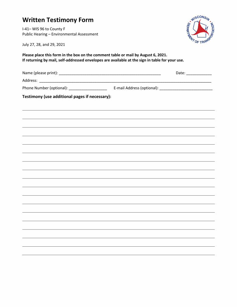
Written Testimony You may provide written testimony in addition to, or in place of, verbal testimony. Complete the “Written Testimony Form” (included in this handout packet or on tables at the in-person public hearing). You may also use your own stationery. Include your name, address, and if applicable, the group, organization, or business you are representing. If you prepared written testimony prior to the public hearing, you may submit that also. There are two options for submitting your written testimony as described below. Submit at the in-person public hearing component: Complete the Written Testimony Form and place the form, along with any other supporting documentation, in the box located at the written testimony table. OR, Mail In: You may prefer this option if you would like additional time to organize your thoughts/testimony. You may mail written testimony to:
Scott Ebel, PE WisDOT Project Manager Northeast Region Office 944 Vanderperren Way Green Bay, WI 54304-5344
You may also email written testimony to: [email protected] All written testimony must be postmarked or received no later than August 6, 2021 to be included in the official public hearing record.
I-41 Project - Public Hearing Page 8
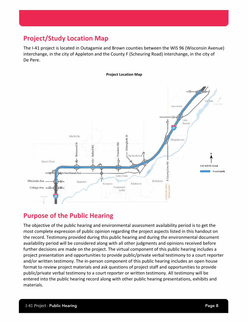
Project/Study Location Map The I-41 project is located in Outagamie and Brown counties between the WIS 96 (Wisconsin Avenue) interchange, in the city of Appleton and the County F (Scheuring Road) interchange, in the city of De Pere.
Project Location Map
Purpose of the Public Hearing The objective of the public hearing and environmental assessment availability period is to get the most complete expression of public opinion regarding the project aspects listed in this handout on the record. Testimony provided during this public hearing and during the environmental document availability period will be considered along with all other judgments and opinions received before further decisions are made on the project. The virtual component of this public hearing includes a project presentation and opportunities to provide public/private verbal testimony to a court reporter and/or written testimony. The in-person component of this public hearing includes an open house format to review project materials and ask questions of project staff and opportunities to provide public/private verbal testimony to a court reporter or written testimony. All testimony will be entered into the public hearing record along with other public hearing presentations, exhibits and materials.
I-41 Project - Public Hearing Page 9
This public hearing will focus on the following aspects of the proposed I-41 project:
• The location and design features of the proposed improvements and the preferred alternative being considered.
• The National Environmental Policy Act (NEPA) and the Wisconsin Environmental Policy Act public hearing process, as applicable, on projects which include preparation of an environmental document. The final environmental document prepared following this public hearing will be the decision document for the proposed improvements. An electronic copy of the Environmental Assessment is available for review on the project website. Copies of the Environmental Assessment are also available for review at the in-person public hearing and at the following locations (please note, a fee may be required for copying service):
o WisDOT Northeast Region office (please schedule an appointment) 944 Vanderperren Way Green Bay, WI 54304 (920) 360-2225 [email protected]
o Appleton Public library 225 N Oneida Street Appleton, WI 54911
o Little Chute Public Library 625 Grand Avenue Little Chute, WI 54140
o Kaukauna Public Library 207 Thilmany Rd #200 Kaukauna, WI 54130
o Brown County Library - Wrightstown Branch 615 Main St Wrightstown, WI 54180
o Brown County Library - Kress Family Branch 333 N Broadway De Pere, WI 54115
• Placing fill into waters of the United States, including wetlands, will require authorization from the U.S. Army Corps of Engineers under the Clean Water Act.
Environmental Document Process FHWA and WisDOT have prepared an Environmental Assessment to document the impacts of the I-41 project. The Environmental Assessment documents the purpose and need for the proposed improvements, alternatives considered, environmental impacts of the alternatives retained for detailed study, and public involvement and agency coordination during the project.
After testimony on the Environmental Assessment is received and considered, a determination of significance of the impacts is made. If it is determined that the project would result in significant impacts, and Environmental Impact Statement (EIS) must be prepared. If it is evident that no significant impacts are associated with the project, a Finding of No Significant Impacts (FONSI) is prepared. The final environmental document will summarize the results of public testimony provided during the public hearing and document availability period along with agency comments on the Environmental Assessment.
I-41 Project - Public Hearing Page 10
Information for the Public Hearing Record In addition to the testimony provided at this public hearing, all exhibits, handouts, audio/visual presentations and displays available for viewing at the public hearing will be included in the official public hearing record. Page 26 of this handout contains a complete listing of these materials. Other materials, along with other written testimony received after the public hearing, will be added to the official public hearing record provided they are postmarked or received no later than August 6, 2021.
Project Statement WisDOT is preparing preliminary engineering plans and conducting environmental analyses for the proposed I-41 improvements between WIS 96 (Wisconsin Avenue) and County F (Scheuring Road), a distance of approximately 23 miles.
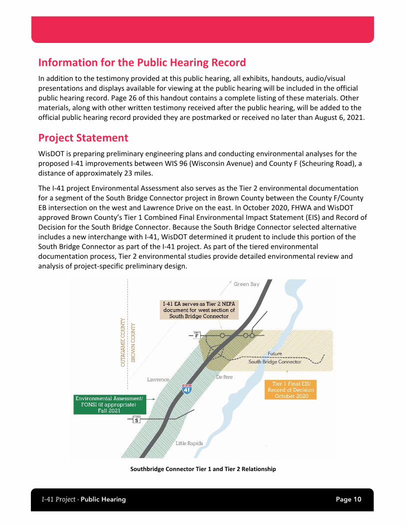
The I-41 project Environmental Assessment also serves as the Tier 2 environmental documentation for a segment of the South Bridge Connector project in Brown County between the County F/County EB intersection on the west and Lawrence Drive on the east. In October 2020, FHWA and WisDOT approved Brown County’s Tier 1 Combined Final Environmental Impact Statement (EIS) and Record of Decision for the South Bridge Connector. Because the South Bridge Connector selected alternative includes a new interchange with I-41, WisDOT determined it prudent to include this portion of the South Bridge Connector as part of the I-41 project. As part of the tiered environmental documentation process, Tier 2 environmental studies provide detailed environmental review and analysis of project-specific preliminary design.
Southbridge Connector Tier 1 and Tier 2 Relationship
I-41 Project - Public Hearing Page 11
Purpose and Need The purpose of the I-41 project is to provide a safe, reliable highway that meets interstate standards and addresses safety and operational deficiencies. In addition, another purpose of the project is also to address the outdated Wrightstown Safety and Weight Enforcement Facility (SWEF) to allow it to operate effectively with proposed improvements to I-41.
The need for the project is summarized below:
• Safety – High Crash Rates WisDOT measures highway safety by the frequency and severity of crashes over a 5-year period and the annual rate of crashes compared to similar roadways statewide. On I-41 in the study area, there were 1,640 crashes (not including deer or other animal crashes) from 2015 to 2019, close to one crash every day. Approximately 22 percent of the crashes resulted in injuries and six were fatal.
In addition to injuries and fatalities, frequent crashes contribute to congestion and unexpected delays, leading to travel time uncertainty. The extent of the congestion depends on the severity of the crash and number of lanes affected. These unexpected delays increase travel times and decrease the travel time reliability of I-41 and local roads. For businesses that rely on timely shipment of products to or from their business, travel time reliability is as important as the travel time itself.
Improving safety on I-41 would improve traffic flow, reducing the travel time for all trips. It would also lower overall transportation costs for motorists by reducing auto repair costs, injury-recovery costs, and costs related to time spent in traffic.
• Capacity – Existing and Future Traffic Operations Reducing congestion and traffic delays and improving reliability on I-41 would reduce transportation costs for all trips while improving traffic flow.
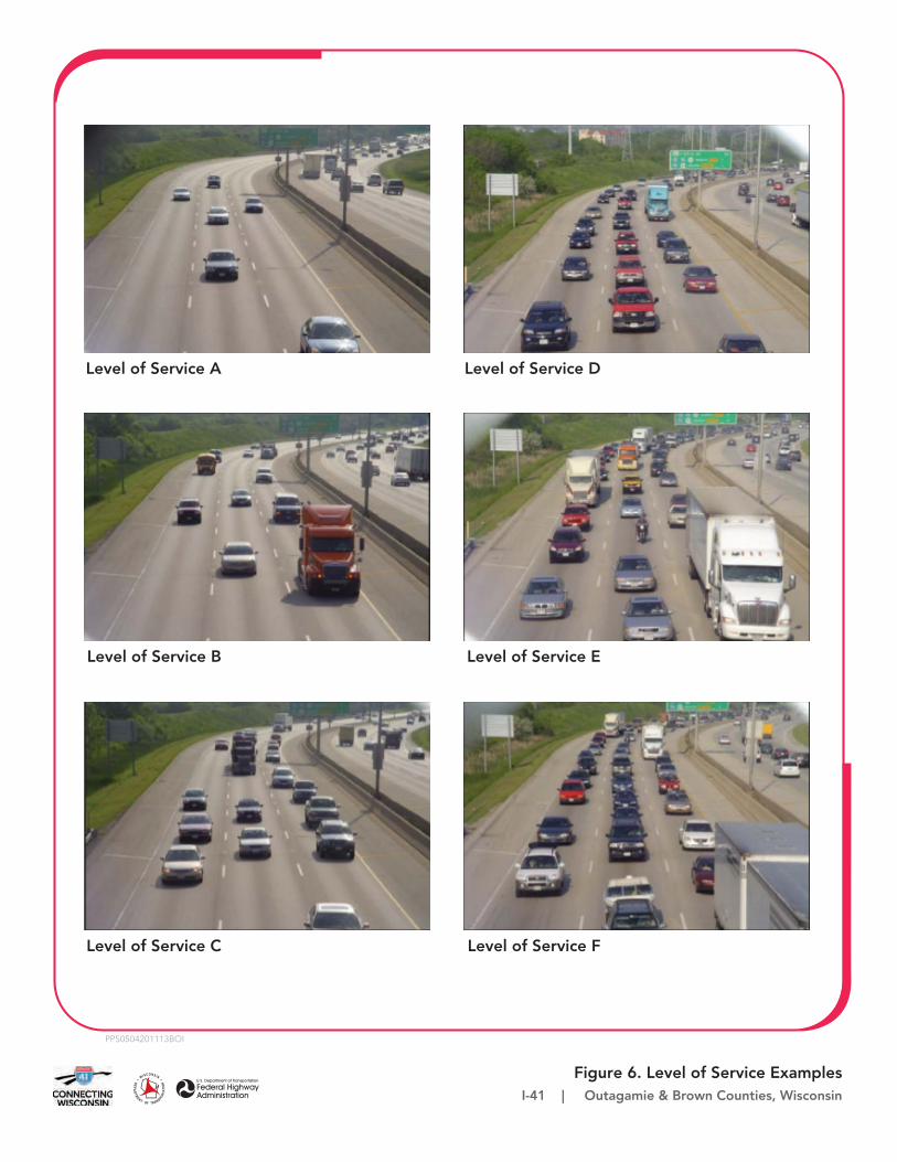
One way of measuring congestion on a highway is level of service. Level of service is the measure of a highway’s ability to handle traffic demand based on density of traffic and is defined from “A” to “F” in order of decreasing operational. Freeway level of service is based on the number of vehicles per hour per lane, with level of service A exhibiting free-flow traffic, and level of service F exhibiting severe congestion that approaches gridlock.
During the morning and afternoon rush hour, the level of service on I-41 generally ranges between levels of service A and D in the urbanized sections of the corridor. The exceptions to this are I-41 southbound near WIS 47 in the morning peak period, and I-41 northbound near WIS 47 in the afternoon peak period which already operate at level of service E.
Since 2012, traffic on this segment of I-41 has increased by approximately 20 to 30 percent. During that same period traffic increased by approximately 10 percent nationwide on all roads (FHWA 2020). If no improvements are made, increased traffic volumes by 2045 will cause several areas of I-41 to operate at a level of service E or F in the urbanized sections, and a
I-41 Project - Public Hearing Page 12
level of service D or E in the rural sections. Many of the areas that were level of service D or worse in 2020 would continue to have congestion and degrade to level of service E or F in the future.
• Roadway Deficiencies
Pavement Condition Much of the I-41 pavement was built in the 1960s, and although pavement maintenance continues, the pavement has reached the end of its useful life, and further rehabilitations are no longer cost effective. The pavement between WIS 96 and County J was repaired in 1989, 1991, and 1993, and a full resurfacing and concrete repair was completed in 2009. I-41 north of County J received repairs and resurfacing in 1987, 2003, and 2017. Several sections received smaller repairs as well throughout the years.
In general, each highway resurfacing and repair has a shorter life span than the previous resurfacing because the original pavement provides a less effective base as the concrete continues to crack and deteriorate. I-41 has reached the stage where additional resurfacings would not be cost effective.
Bridge Conditions There are 37 bridges in the study area carrying vehicle traffic, 19 of which carry I-41 traffic. The other bridges carry cross streets over I-41. There is also one pedestrian bridge over I-41 between WIS 96 and WIS 15.
The bridges have deteriorated over the years due to age, heavy traffic, road salt, freeze thaw cycles, and water entering cracks in the bridges. Additionally, at some locations there are bridges that do not meet the desirable vertical clearance (the vertical distance from pavement to the lowest portion of the bridge above the roadway).
Roadway Design Deficiencies There are numerous locations with narrow shoulders, insufficient ramp designs, and closely spaced interchanges along I-41. These deficiencies reduce safety and contribute to operational problems throughout the study area.
I-41 Project - Public Hearing Page 13
• Wrightstown Safety Weight Enforcement Facility (SWEF) As part of this project, WisDOT is considering rebuilding the Wrightstown SWEF in Outagamie County, which is accessible from northbound I-41, about 0.75 miles south of County U. The existing SWEF does not have modern technology to weigh and inspect commercial motor vehicle truck traffic.
In addition to replacing the SWEF, the State Patrol may move its Northeast Region Headquarters (currently in Fond du Lac) to this site. This would include the addition of a 300 to 350-foot communications tower. The current headquarters needs upgrading and replacing it with a new building co-located with the SWEF would save money. Relocating the State Patrol Northeast Region Headquarters from Fond du Lac to the Wrightstown SWEF site would also make the headquarters more centrally located within the region.
These actions are part of the I-41 project because reconstructing I-41 would impact access and operations at the current SWEF site. The potential impacts of a redesign of the SWEF and potential addition of a new State Patrol regional headquarters would be considered as part of the design of I-41 and the ramps to the facility.
Alternatives Description WisDOT developed a range of alternatives to meet the purpose and need of the project. Alternatives were developed and analyzed for:
• I-41 • Nine interchanges • Safety and Weight Enforcement Facility (SWEF)
WisDOT also considered improvements for the existing park and ride lots along the corridor as well as the construction of a new salt shed on the Outagamie County Highway Department grounds.
WisDOT analyzed a no-build alternative along with several build alternatives. Each alternative was evaluated based on how it addressed the project’s need factors, potential environmental impacts, new right of way required, and estimated construction cost. WisDOT also considered input from the public, tribes, agencies, and local governments.
No-Build Alternative Under the no-build alternative, WisDOT would make no improvements to I-41 other than routine maintenance. There would continue to be four lanes (two lanes in each direction). In addition, WisDOT would make no changes or improvements to the interchanges along I-41 or to the SWEF, park and ride lots or salt shed.
Although the no-build alternative would have minimal environmental impacts and only routine maintenance cost, it does not meet the need for the project for the following reasons:
• It does not address high crash rates • It does not address the traffic operational needs along I-41 • It does not address roadway deficiencies • It does not upgrade the SWEF
I-41 Project - Public Hearing Page 14
I-41 Alternatives A range of alternatives for I-41 improvements were considered to address the project’s need factors. The range of alternatives considered include the following:
• Transportation Systems Management (TSM) and Travel Demand Management (TDM) - This alternative consists of measures that involve managing traffic and travel demand through lower-cost means. TSM optimizes existing transportation system to maximize carrying capacity and travel efficiency. TSM typically would include things like ramp meters, freeway advisory signs, traffic detectors and incident management. TDM includes elements to reduce personal vehicular travel and would typically include public transit and park and ride lots to encourage ridesharing. WisDOT would continue to include these elements as recommended in the regional long-range plan.
• Four-lane with Hard Shoulder Running (HSR) – This alternative allows vehicles to drive on the paved shoulder when traffic is heavy.
• Six-lane
Six-lane Alternative (Preferred Alternative) WisDOT eliminated the no-build, TSM, and TDM alternatives from consideration because they would not meet the project’s need factors. They would not improve safety, improve traffic operations, address existing design deficiencies, or provide system continuity.
The four-lane with HSR alternative would not fully meet the project’s need because it does not provide lane and route continuity with adjacent sections of I-41 when HSR is not active. While improving safety and traffic operations over the no-build condition, it does not address the safety or traffic operation need factors to the same extent as the six-lane alternative.
The six-lane alternative meets all project purpose and need elements as it is the safest I-41 alternative, best addresses future traffic operations, and is the only alternative that would provide lane and route continuity.
The six-lane alternative would reconstruct and upgrade I-41 to current design standards and would add an additional travel lane in each direction. The additional travel lane would be added in the median to reduce the need to acquire additional property from adjacent property owners. A concrete median barrier would separate the two directions of traffic rather than the current grass median. The proposed design includes 12-foot lanes and 12-foot shoulders on each side, as well as traffic cameras and dynamic message signs.
As part of the six-lane alternative, the SWEF would be reconstructed, and the Northeast Region Headquarters of the Wisconsin State Patrol would be moved to the SWEF site. This alternative would also construct a new Outagamie County salt shed and resurface three WisDOT park and ride lots.
Overpass Reconstruction In addition to reconstructing all the interchanges with I-41, WisDOT will replace six of the eight local and County Road overpasses over I-41. The reconstructed overpasses may be wider than the existing ones to accommodate bicyclists and pedestrians, or to meet minimum design standards.
I-41 Project - Public Hearing Page 15
Interchange Alternatives In addition to the no-build alternative, WisDOT developed one or more build alternatives for each interchange. The alternatives were developed and evaluated based on meeting the project’s need, environmental impacts, public and local government input, and cost.
Interchange Alternatives Considered There is one system interchange, at WIS 441, in the corridor. A system interchange connects two or more freeways with free-flow ramps. The traffic within system interchanges moves freely without stopping. WisDOT considered replacing this interchange in a similar alignment to the existing configuration as well as two new alternatives with flyover ramps.
There are eight existing and one planned service interchanges in the corridor between WIS 96 and County F. Service interchanges provide access between the freeway (in this case I-41) and local surface streets. Multiple alternatives were considered for most of the service interchanges along I-41.
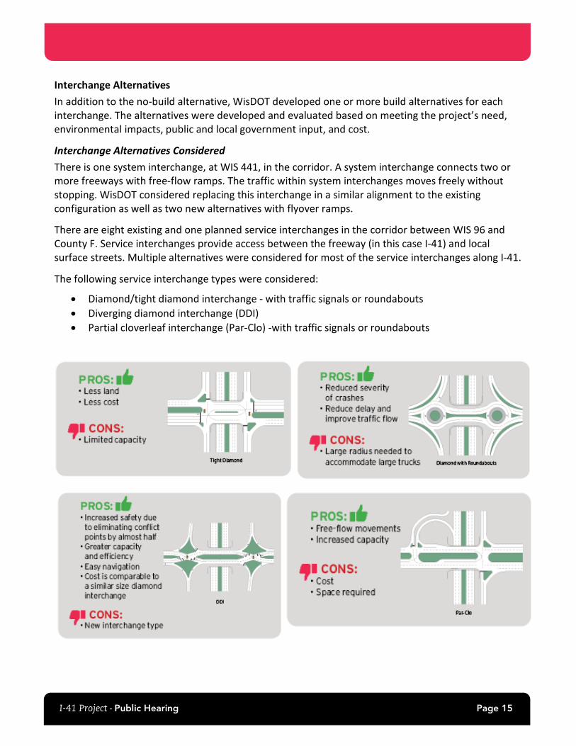
The following service interchange types were considered:
• Diamond/tight diamond interchange - with traffic signals or roundabouts • Diverging diamond interchange (DDI) • Partial cloverleaf interchange (Par-Clo) -with traffic signals or roundabouts
I-41 Project - Public Hearing Page 16
The alternatives considered at each interchange meet the project’s needs by improving safety, upgrading to current design standards to address roadway deficiencies, and operating at an acceptable level of service.
In addition to the preferred alternatives listed below, the no-build alternative was considered for each interchange. Under the no-build alternative, there would be no improvements to the interchanges other than routine maintenance. This would not address the need for the project and was therefore eliminated from further consideration for each interchange.
A detailed description of the alternatives considered at each interchange is included in the project Environmental Assessment available online at www.wisconsindot.gov/I41project
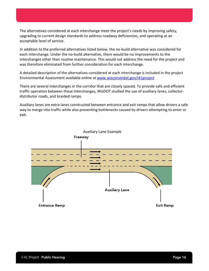
There are several interchanges in the corridor that are closely spaced. To provide safe and efficient traffic operation between these interchanges, WisDOT studied the use of auxiliary lanes, collector-distributor roads, and braided ramps.
Auxiliary lanes are extra lanes constructed between entrance and exit ramps that allow drivers a safe way to merge into traffic while also preventing bottlenecks caused by drivers attempting to enter or exit.
Auxiliary Lane Example
I-41 Project - Public Hearing Page 17
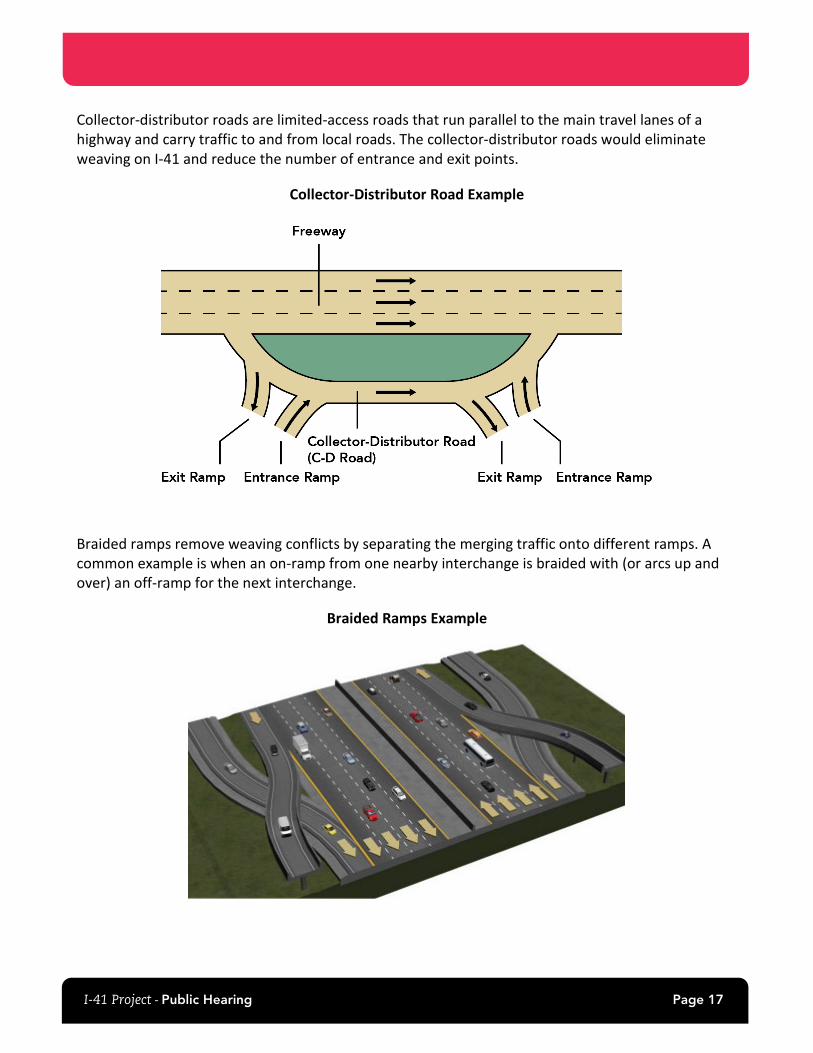
Collector-distributor roads are limited-access roads that run parallel to the main travel lanes of a highway and carry traffic to and from local roads. The collector-distributor roads would eliminate weaving on I-41 and reduce the number of entrance and exit points.
Collector-Distributor Road Example
Braided ramps remove weaving conflicts by separating the merging traffic onto different ramps. A common example is when an on-ramp from one nearby interchange is braided with (or arcs up and over) an off-ramp for the next interchange.
Braided Ramps Example
I-41 Project - Public Hearing Page 18
Connection between WIS 96 (Wisconsin Avenue) and WIS 15/County OO Interchanges on I-41 Because the WIS 96 and WIS 15/County OO interchanges are only 3,000 feet apart, WisDOT evaluated three options to configure I-41 between the two closely spaced interchanges to provide safe and efficient traffic operations.
WisDOT identified auxiliary lanes as the preferred alternative for the connection between the WIS 96 and WIS 15 interchanges. The auxiliary lane would provide similar safety benefits for current and future traffic volumes as collector-distributor roads and braided ramps while requiring less new right of way and cost.
I-41 and WIS 15/County OO (Northland Avenue) Interchange The existing WIS 15/County OO interchange is a diamond interchange with a partial cloverleaf in the northwest quadrant and traffic signals.
WisDOT identified the diverging diamond interchange as the preferred alternative. The diverging diamond interchange was identified because it best addresses traffic operations at the interchange, improves safety, and has minimal impacts.
I-41 and WIS 47 (Richmond Street) Interchange The existing WIS 47 interchange is a tight diamond interchange with traffic signals.
WisDOT identified the diverging diamond interchange as the preferred alternative for the WIS 47 interchange. The diverging diamond interchange was identified because it best addresses traffic operations at the interchange, improves safety, and has minimal impacts.
As part of this alternative, the east end of Association Drive would become a cul-de-sac and no longer connect to WIS 47. This would change access for the handful of businesses and residences on Association Drive.
Connection between WIS 47 and County E Interchanges on I-41 WisDOT evaluated three options to configure I-41 between the WIS 47 and County E interchanges to provide safe and efficient traffic operations.
WisDOT identified auxiliary lanes as the preferred alternative for the connection between these two interchanges. The auxiliary lane would provide similar safety benefits for current and future traffic volumes as collector-distributor roads and braided ramps while requiring less new right of way and cost.
I-41 and County E (Ballard Road) Interchange The existing County E interchange is a diamond interchange with traffic signals. WisDOT identified the diverging diamond interchange as the preferred alternative for the County E interchange. At the County E interchange, the diverging diamond interchange is the safest interchange option and has the best traffic operations.
I-41 Project - Public Hearing Page 19
Connection between County E and WIS 441 Interchanges on I-41 WisDOT identified the collector-distributor roads as the preferred alternative for the connection between the County E and WIS 441 interchanges. This alternative was identified because it improves safety over the auxiliary lane, requires less right-of-way, and is less expensive than the braided ramps, provides an acceptable level of service for traffic operations, and has the support of Outagamie County.
I-41 and WIS 441 System Interchange The WIS 441 system interchange has a high volume of weaving traffic and is close to County E to the west and County OO to the south.
WisDOT assessed the following alternatives for reconstructing the WIS 441 system interchange:
• Loop ramp similar to current layout • 55-mile-per-hour design speed flyover ramps • 60-mile-per-hour design speed flyover ramps
WisDOT eliminated the layout that was similar to the existing because the loop ramp would have a 35-mile-per-hour design speed, deemed too low for a system interchange on a freeway that will have a 70-mile-per-hour design speed. There is little operational and safety difference between the 55-mile-per-hour and 60-mile-per-hour design speed ramps so WisDOT identified the 55-mile-per-hour flyover ramp alternative as the preferred alternative for the WIS 441 interchange.
While the 55- and 60-mile-per-hour alternatives meet the need for the project, the 55-mile-per-hour alternative requires less land from adjacent property owners, has less impacts, and costs less than the 60 mile-per-hour alternative while offering similar operational and safety benefits.
Connection between I-41 and County OO Interchanges on WIS 441 Because the WIS 441 interchange with I-41 and with County OO are 0.75 miles apart, WisDOT evaluated three options to configure WIS 441 between the two closely spaced interchanges to provide safe and efficient traffic operations.
WisDOT identified the auxiliary lane as the preferred northbound alternative and the braided ramp as the preferred southbound alternative on WIS 441 between County OO and I-41.
The auxiliary lane would provide similar safety benefits for current and future traffic volumes, while requiring less land from adjacent property owners, and cost. Braided ramps meet FHWA freeway design criteria and avoid weaving conflicts between vehicles. This alternative also avoids right of way acquisition and resource impacts needed to reconstruct WIS 441/County OO interchange as a partial cloverleaf interchange.
I-41 and County N (Freedom Road) Interchange
The County N interchange is a diamond interchange with traffic signals. A diamond interchange with traffic signals was the only build alternative considered for this location as the interchange operates acceptably as a diamond interchange with traffic signals today, and future traffic volumes are projected to remain close to current volumes.
I-41 Project - Public Hearing Page 20
I-41 and WIS 55 (Delanglade Street) Interchange The I-41 and WIS 55 interchange is a diamond interchange with roundabouts. The interchange was reconstructed in 2018 to add roundabouts, and thus the roundabouts meet current standards and do not require reconstruction.
An additional lane along southbound WIS 55 would be constructed from the north roundabout to the south roundabout to account for projected traffic volumes. The interchange ramps would also be reconstructed to tie into I-41, and the I-41 bridges over WIS 55 and Maloney Road, about 1,000 feet east of WIS 55, would be reconstructed.
Connection between WIS 55 and County J (Lawe Street) Interchanges on I-41 WisDOT evaluated three options to configure I-41 between the two closely spaced interchanges to provide safe and efficient traffic operations.
WisDOT identified auxiliary lanes as the preferred alternative for the connection between the WIS 55 and County J interchanges. An auxiliary lane would provide similar safety benefits for current and future traffic volumes as collector-distributor roads and braided ramps while requiring less new right of way and cost.
I-41 and County J (Lawe Street) Interchange The I-41 and County J interchange is a diamond interchange with roundabouts. This interchange was reconstructed in 2010 to add roundabouts, and thus the roundabouts meet current standards and do not require reconstruction.
The interchange ramps would be reconstructed to tie into I-41, and the County J bridge over I-41 would be reconstructed due to the location of the existing bridge piers. Reconstructing the ramps in their current alignment meets the need of the project with minimal environmental impacts.
I-41 and County U (County Line Road) Interchange The I-41 and County U interchange is a diamond interchange with stop signs.
WisDOT identified the diamond interchange with roundabouts as the preferred alternative for the County U interchange due to its ability to handle future traffic volumes.
I-41 and County S (Freedom Road) Interchange The I-41 and County S interchange is a diamond interchange with stop signs.
WisDOT identified the diamond interchange with roundabouts as the preferred alternative for the County S interchange. This alternative would best handle future traffic volumes and have less impacts than the relocated frontage road alternatives.
I-41 Project - Public Hearing Page 21
I-41 and South Bridge Connector (County EB/GV) Interchange There is no existing interchange at I-41 and Southbridge Road/Orange Lane. As part of this I-41 project, WisDOT would construct a new interchange at this location to provide I-41 access to the Brown County South Bridge Connector.
WisDOT identified the diamond interchange with roundabouts as the preferred alternative for the new South Bridge Connector interchange. This alternative has the best operational performance and meets safety and design standards.
Connection between the South Bridge Connector and County F (Scheuring Road) on I-41 WisDOT and FHWA considered a collector-distributor road along I-41 between the new South Bridge Connector interchange and the existing County F interchange one mile to the north. As part of this Tier 2 environmental document, this area was studied in greater detail and auxiliary lanes were considered for this segment of I-41. Both the collector-distributor road option and auxiliary lanes option would operate at an acceptable level of service between the proposed South Bridge Connector interchange and the County F interchange. Based on the distance between the interchanges, the added cost of a collector-distributor road would not be needed from either an operations or safety standpoint.
Based on the similar traffic operational quality and safety, and less impacts and lower cost, WisDOT identified auxiliary lanes between the South Bridge Connector interchange and the existing County F interchange as the preferred alternative. The auxiliary lanes would require less space and would cost less to construct.
Wrightstown Safety and Weight Enforcement Facility (SWEF) The Northbound Alternative is the preferred alternative for the SWEF because it uses existing right of way with no acquisition or relocations required, has less environmental impacts, is safer, keeps existing frontage roads intact, and costs less than the Southbound Alternative.
The reconstructed SWEF would also house the State Patrol’s Northeast District Headquarters in a two-story building with a 300 to 350-foot communications tower on the property. The site would include parking stalls for out-of-service large trucks, parking stalls for the public, secure parking for WisDOT and State Patrol vehicles, and stormwater ponds. Secure WisDOT and State Patrol access may also be provided from East Frontage Road.
I-41 Project - Public Hearing Page 22
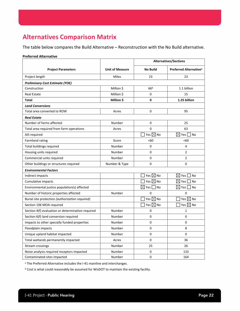
Alternatives Comparison Matrix The table below compares the Build Alternative – Reconstruction with the No Build alternative.
Preferred Alternative
Project Parameters Unit of Measure
Alternatives/Sections
No Build Preferred Alternativea
Project length Miles 23 23
Preliminary Cost Estimate (YOE) Construction Million $ 66b 1.1 billion
Real Estate Million $ 0 15
Total Million $ 0 1.25 billion
Land Conversions Total area converted to ROW Acres 0 95
Real Estate Number of farms affected Number 0 25
Total area required from farm operations Acres 0 63
AIS required Yes No Yes No
Farmland rating Score <60 <60
Total buildings required Number 0 4
Housing units required Number 0 2
Commercial units required Number 0 2
Other buildings or structures required Number & Type 0 0
Environmental Factors Indirect impacts Yes No Yes No
Cumulative impacts Yes No Yes No
Environmental justice population(s) affected Yes No Yes No
Number of historic properties affected Number 0 0
Burial site protection (authorization required) Yes No Yes No
Section 106 MOA required Yes No Yes No
Section 4(f) evaluation or determination required Number 0 1
Section 6(f) land conversion required Number 0 0
Impacts to other specially funded properties Number 0 0
Floodplain impacts Number 0 8
Unique upland habitat impacted Number 0 0
Total wetlands permanently impacted Acres 0 36
Stream crossings Number 25 26
Noise analysis required receptors impacted Number 0 133 Contaminated sites impacted Number 0 164 a The Preferred Alternative includes the I-41 mainline and interchanges. b Cost is what could reasonably be assumed for WisDOT to maintain the existing facility.
I-41 Project - Public Hearing Page 23
Noise Barriers WisDOT conducted a noise analysis and six new noise barriers and the existing noise wall in the project area were determined to be feasible and reasonable:
• I-41 Northbound from Capitol Drive to Lynndale Drive • I-41 Northbound from Lynndale Drive to WIS 47 • I-41 Southbound from railroad tracks to Lynndale Drive • I-41 Northbound from WIS 47 to Meade Street (existing) • I-41 Southbound from Meade Street to approx. 2,500 ft west of Meade Street • I-41 Northbound from Meade Street to Ballard Road • I-41 Northbound from Rose Hill Road to WIS 55
In order to be built, each barrier must receive a vote of support by a simple majority of the property owners and the residents benefited by the barrier. The voting process, which includes a public involvement meeting about the noise barriers, will occur during final design (anticipated 2023). This meeting will also provide owners and residents of the surrounding area an opportunity to ask questions about the noise barriers. The locations studied in the noise analysis are available for viewing on the project website, during the virtual public hearing, and will be on display at the in-person component of the public hearing.
Section 4(f) Impacts Section 4(f) properties are publicly owned parks, recreation areas, wildlife or waterfowl refuges and any publicly or privately owned significant historical or archeological site. Section 4(f) is applicable to all federally funded transportation projects like I-41.
Three Section 4(f) resources would be affected by the project. There would be permanent impacts to two Section 4(f) resources and temporary impacts to one resource. The project would permanently incorporate about 0.2 acre of land from the Outagamie County Forest. This land is in the very northeast corner and does not have any recreational amenities. The Project would also permanently incorporate about 0.9 acre of land from the Town of Grand Chute’s Prairie Hill Park. The land to be acquired is unimproved and along the western edge of the park, adjacent to I-41, and does not have any recreational amenities.
WisDOT intends to pursue Section 4(f) de minimis impact determinations at the County Forest and Prairie Hill Park. A de minimis impact determination is possible if the project would not adversely affect the activities, features, or attributes qualifying the park, recreation area, or refuge for protection under Section 4(f). A de minimis determination would also require concurrence from Outagamie County and the Town of Grand Chute, as well as public input.
During construction, the Ballard Road bridge over I-41 will be reconstructed, resulting in a temporary occupancy of the trail segment that is on the bridge. The Project would not result in any adverse effect to the activities, features, or attributes that qualify the Ballard Road Trail for protection under Section 4(f).
I-41 Project - Public Hearing Page 24
Property Acquisition/Relocation Assistance and Benefits Before any property acquisition activities are initiated, members of the Region Real Estate staff will contact the property owner to explain the details of the acquisition process and Wisconsin's Eminent Domain Law. All properties to be acquired will be inspected and appraised by one or more professional appraisers. The property owner will be asked to accompany the appraiser during inspection of the property to be acquired, to assure that its value is recognized in the appraisal. Based upon the appraisal or appraisals made, the fair market value of the property to be acquired will be determined, and that amount will be offered to the owner.
It is anticipated that two homes and two businesses will need to be acquired as a result of this project. It is also anticipated that approximately 95 acres of new right of way acquisition will be needed for this project. Relocation assistance will be made available to anyone displaced by this project. In this regard, a survey of available housing and business locations was made on March 22, 2021. This survey indicates that there will be sufficient housing and business locations available in the project vicinity at the time of the proposed relocations, within the means of the relocatees and meeting the requirements for replacement housing and business locations.
The "Relocation Assistance" brochure, available on the project website and at the in-person public hearing, has been prepared to answer many of the general questions frequently asked concerning relocation assistance. Note that in addition to the cost of replacement housing and business locations, additional monies are available to cover moving expenses, increased rental and mortgage payments and interest rates, and any closing costs incurred.
No person shall be displaced unless a comparable and/or adequate replacement housing or business location has been provided or made available. In the event a relocated person is dissatisfied with the decision as to eligibility for payments or amounts offered under the relocation assistance program, he or she will be promptly advised of the procedure to follow in making an appeal.
Property acquisition for this improvement is scheduled to begin in 2023 or 2024. Depending upon the availability of funds and the anticipated completion of relocations by the end of 2024, construction could begin soon thereafter if a build alternative is selected.
I-41 Project - Public Hearing Page 25
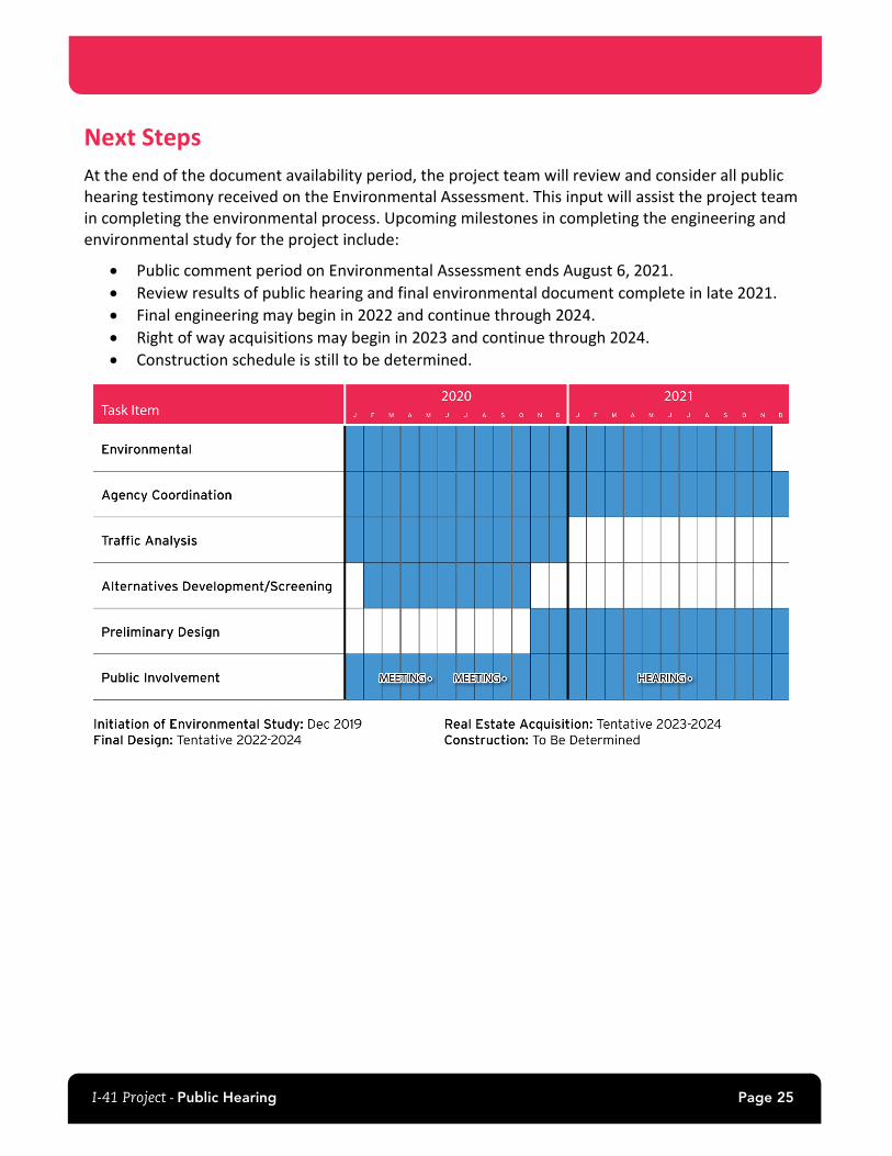
Next Steps At the end of the document availability period, the project team will review and consider all public hearing testimony received on the Environmental Assessment. This input will assist the project team in completing the environmental process. Upcoming milestones in completing the engineering and environmental study for the project include:
• Public comment period on Environmental Assessment ends August 6, 2021. • Review results of public hearing and final environmental document complete in late 2021. • Final engineering may begin in 2022 and continue through 2024. • Right of way acquisitions may begin in 2023 and continue through 2024. • Construction schedule is still to be determined.
I-41 Project - Public Hearing Page 26
Description of Public Hearing Exhibits The following exhibits are available for viewing at the public hearing:
• Social Distancing measures (in-person only) • Explanation of looping presentation
(in-person only) • Directions for attendees that would like
to provide testimony (in-person only) • Please wait to sign-in (in-person only) • Project location map • Purpose and need • Proposed schedule • Preferred alternative map • Alternative evaluation matrix • Reasonable and feasible noise barrier
locations • Section 4(f) impacts • Auxiliary Lane • Collector-Distributor Road • Braided Ramps • Six-lane proposed alternative
• Diverging Diamond Interchange example • Southbridge Road final design and
construction responsibilities • Detailed preferred alternatives
o WIS 15/County OO o WIS 47 o County E o WIS 441 o WIS 441 and County OO
(Northland Avenue) o County N o WIS 55 o County J o County U o County S o South Bridge Connector and
County F o South Bridge Connector o SWEF
The following documents are available for viewing at the public hearing:
• Environmental Assessment that includes the study purpose and need, the range of alternatives considered, impacts and potential mitigation and a summary of public and agency involvement activities.
• Legal notice, which is the notice published in the Green Bay Press Gazette and the Appleton Post Crescent advertising the public hearing and the availability of the Environmental Assessment.
• Preferred alternative strip maps
• Brochure - Landowners Rights under Wisconsin Eminent Domain Law
• Brochure - Noise Barriers: What You Should Know
• Handout – Diverging Diamond Interchange
I-41 Project - Public Hearing Page 27
PowerPoint Presentation WisDOT is providing a brief PowerPoint presentation to update the public on the proposed project alternatives and to explain the public hearing process. The PowerPoint presentation also serves the purpose of providing information required as part of the public hearing Project Statement.
I-41 Project - Public Hearing Page 28
Contact Information Submittal of Written Testimony or General Project Questions
Additional written public hearing testimony on the Environmental Assessment after the public hearing should be sent to the WisDOT project manager at the address or email address given below. Additional testimony will be added to the official public hearing record and considered in the final environmental document provided it is postmarked or received no later than August 6, 2021.
Scott Ebel, P.E. I-41 Design Project Manager Wisconsin Department of Transportation 944 Vanderperren Way Green Bay, WI 54304-5344 (920) 360-2225 [email protected]
Property Acquisition/Relocation Questions
Questions specific to property acquisition and/or relocations of homes and businesses can be most efficiently answered by real estate staff.
Curt Van Erem Wisconsin Department of Transportation 944 Vanderperren Way Green Bay, WI 54304-5344 (920) 360-3791 [email protected]
Project website (project information, schedule and updates)
For the latest project information, go to: wisconsindot.gov/I41project

Page 29
Environmental Assessment Exhibits
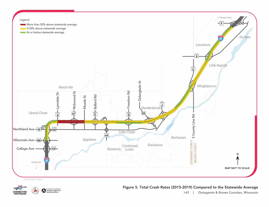
Figure 5. Total Crash Rates (2015-2019) Compared to the Statewide AverageI-41 | Outagamie & Brown Counties, Wisconsin
PPS0504201113BOI
96
125
COUNTY
OO15Northland Ave
Wisconsin Ave
College Ave
47
441
COUNTY
ACOUNTY
E
COUNTY
S
COUNTY
F
COUNTY
J
COUNTY
N55
Green Bay
Little Rapids
Lawrence
De Pere
COUNTY
U
Wrightstown
Fox R
iver
Little Chute
Vandenbroek
Buchanan
CombinedLocks
KaukaunaKimberly
Appleton
BRO
WN
CO
UN
TY
OU
TAG
AM
IE C
OU
NTY
S C
ount
y Li
ne R
d
Del
angl
ade
St
Oshkosh
Mackville
Free
dom
Rd
Bal
lard
Rd
Mea
de S
t
Rich
mon
d St
Lynn
dale
Dr
Grand Chute
MAP NOT TO SCALE
N
Legend:
More than 50% above statewide average0-50% above statewide averageAt or below statewide average
PPS0504201113BOI
Figure 6. Level of Service ExamplesI-41 | Outagamie & Brown Counties, Wisconsin
Level of Service C
Level of Service A
Level of Service B
Level of Service F
Level of Service D
Level of Service E
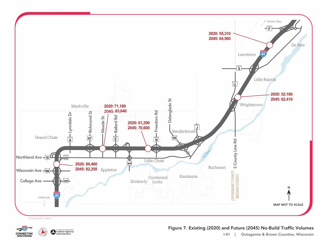
Figure 7. Existing (2020) and Future (2045) No-Build Traffic VolumesI-41 | Outagamie & Brown Counties, Wisconsin
PPS0504201113BOI
96
125
COUNTY
OO15Northland Ave
Wisconsin Ave
College Ave
47
441
COUNTY
ACOUNTY
E
COUNTY
S
COUNTY
F
COUNTY
J
COUNTY
N55
Green Bay
Little Rapids
Lawrence
De Pere
COUNTY
U
Wrightstown
Fox R
iver
Little Chute
Vandenbroek
Buchanan
CombinedLocks
KaukaunaKimberly
Appleton
BRO
WN
CO
UN
TY
OU
TAG
AM
IE C
OU
NTY
S C
ount
y Li
ne R
d
Del
angl
ade
St
Oshkosh
Mackville
Free
dom
Rd
Bal
lard
Rd
Mea
de S
t
Rich
mon
d St
Lynn
dale
Dr
Grand Chute
MAP NOT TO SCALE
N
2020: 71,1802045: 83,640
2020: 61,2902045: 70,600
2020: 69,4602045: 82,250
2020: 52,1802045: 62,410
2020: 55,3102045: 64,560

Figure 8. Existing (2020) Traffic Operations - Morning Peak HoursI-41 | Outagamie & Brown Counties, Wisconsin
PPS0504201113BOI
RURALSEGMENT
96
125
COUNTY
OO15Northland Ave
Wisconsin Ave
College Ave
47
441
COUNTY
ACOUNTY
E
COUNTY
S
COUNTY
F
COUNTY
J
COUNTY
N55
Green Bay
Little Rapids
Lawrence
De Pere
COUNTY
U
Wrightstown
Fox R
iver
Little Chute
Vandenbroek
Buchanan
CombinedLocks
KaukaunaKimberly
Appleton
BRO
WN
CO
UN
TY
OU
TAG
AM
IE C
OU
NTY
S C
ount
yLi
ne R
d
Del
angl
ade
St
Oshkosh
Mackville
Free
dom
Rd
Bal
lard
Rd
Mea
de S
t
Rich
mon
d St
Lynn
dale
Dr
Grand Chute
Legend:
Level of Service A or B Level of Service C Level of Service DLevel of Service ELevel of Service F
MAP NOT TO SCALE
N
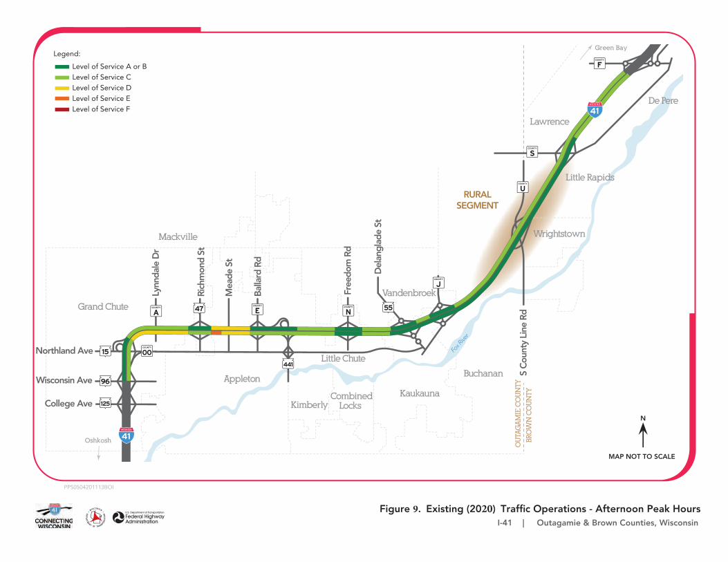
Figure 9. Existing (2020) Traffic Operations - Afternoon Peak HoursI-41 | Outagamie & Brown Counties, Wisconsin
PPS0504201113BOI
RURALSEGMENT
96
125
COUNTY
OO15Northland Ave
Wisconsin Ave
College Ave
47
441
COUNTY
ACOUNTY
E
COUNTY
S
COUNTY
F
COUNTY
J
COUNTY
N55
Green Bay
Little Rapids
Lawrence
De Pere
COUNTY
U
Wrightstown
Fox R
iver
Little Chute
Vandenbroek
Buchanan
CombinedLocks
KaukaunaKimberly
Appleton
BRO
WN
CO
UN
TY
OU
TAG
AM
IE C
OU
NTY
S C
ount
yLi
ne R
d
Del
angl
ade
St
Oshkosh
Mackville
Free
dom
Rd
Bal
lard
Rd
Mea
de S
t
Rich
mon
d St
Lynn
dale
Dr
Grand Chute
Legend:
Level of Service A or B Level of Service C Level of Service DLevel of Service ELevel of Service F
MAP NOT TO SCALE
N
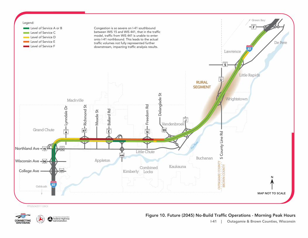
Figure 10. Future (2045) No-Build Traffic Operations - Morning Peak HoursI-41 | Outagamie & Brown Counties, Wisconsin
PPS0504201113BOI
RURALSEGMENT
96
125
COUNTY
OO15Northland Ave
Wisconsin Ave
College Ave
47
441
COUNTY
ACOUNTY
E
COUNTY
S
COUNTY
F
COUNTY
J
COUNTY
N55
Green Bay
Little Rapids
Lawrence
De Pere
COUNTY
U
Wrightstown
Fox R
iver
Little Chute
Vandenbroek
Buchanan
CombinedLocks
KaukaunaKimberly
Appleton
BRO
WN
CO
UN
TY
OU
TAG
AM
IE C
OU
NTY
S C
ount
yLi
ne R
d
Del
angl
ade
St
Oshkosh
Mackville
Free
dom
Rd
Bal
lard
Rd
Mea
de S
t
Rich
mon
d St
Lynn
dale
Dr
Grand Chute
Legend:
Level of Service A or B Level of Service C Level of Service DLevel of Service ELevel of Service F
Congestion is so severe on I-41 southbound between WIS 15 and WIS 441, that in the traffic model, traffic from WIS 441 is unable to enter onto I-41 northbound. This leads to the actual traffic volumes not fully represented further downstream, impacting traffic analysis results.
MAP NOT TO SCALE
N
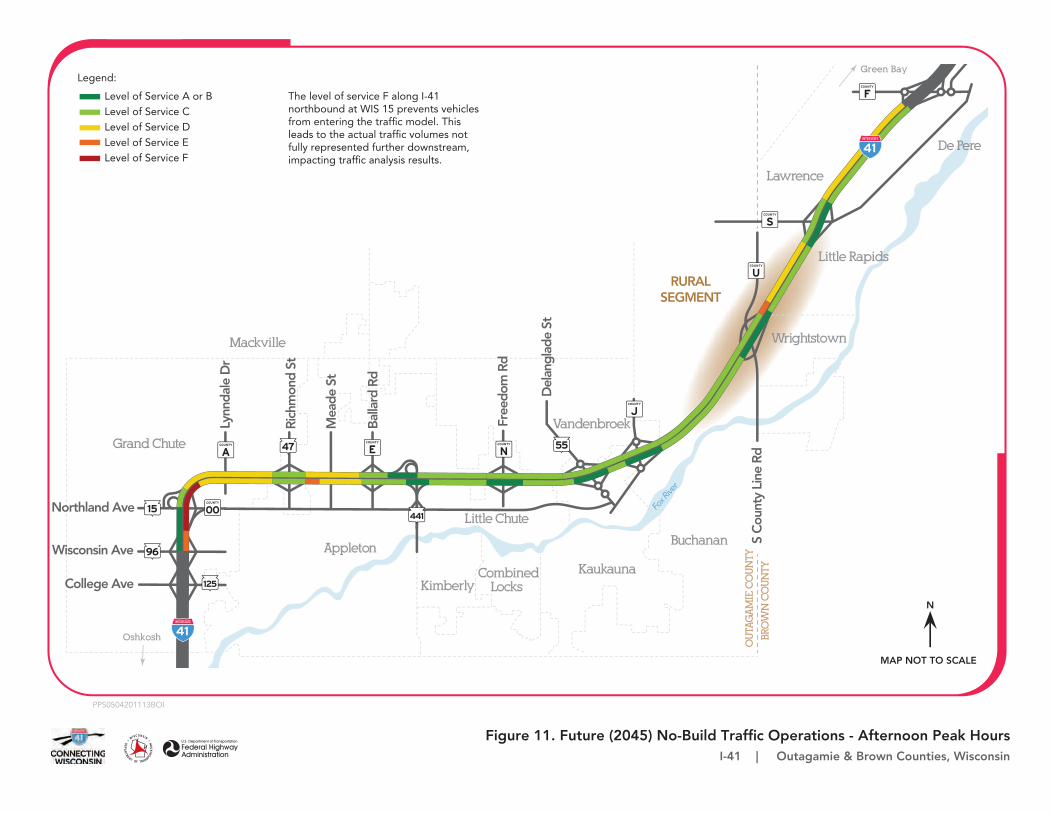
Figure 11. Future (2045) No-Build Traffic Operations - Afternoon Peak HoursI-41 | Outagamie & Brown Counties, Wisconsin
PPS0504201113BOI
RURALSEGMENT
96
125
COUNTY
OO15Northland Ave
Wisconsin Ave
College Ave
47
441
COUNTY
ACOUNTY
E
COUNTY
S
COUNTY
F
COUNTY
J
COUNTY
N55
Green Bay
Little Rapids
Lawrence
De Pere
COUNTY
U
Wrightstown
Fox R
iver
Little Chute
Vandenbroek
Buchanan
CombinedLocks
KaukaunaKimberly
Appleton
BRO
WN
CO
UN
TY
OU
TAG
AM
IE C
OU
NTY
S C
ount
yLi
ne R
d
Del
angl
ade
St
Oshkosh
Mackville
Free
dom
Rd
Bal
lard
Rd
Mea
de S
t
Rich
mon
d St
Lynn
dale
Dr
Grand Chute
Legend:
Level of Service A or B Level of Service C Level of Service DLevel of Service ELevel of Service F
The level of service F along I-41 northbound at WIS 15 prevents vehicles from entering the traffic model. This leads to the actual traffic volumes not fully represented further downstream, impacting traffic analysis results.
MAP NOT TO SCALE
N
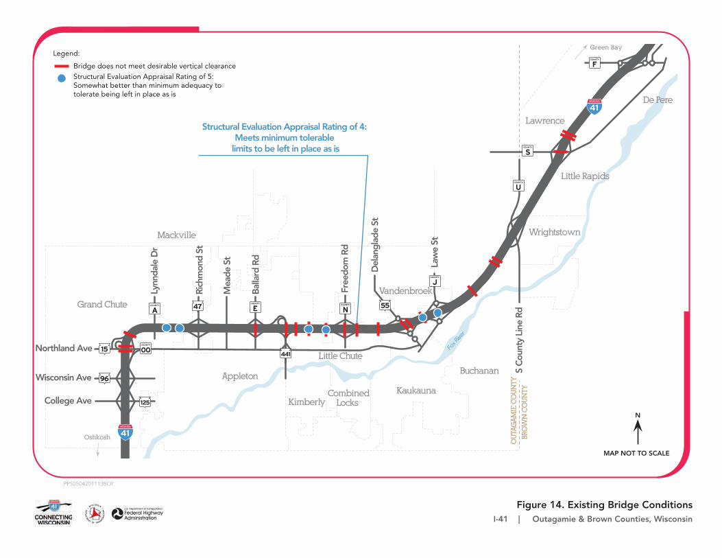
Figure 14. Existing Bridge ConditionsI-41 | Outagamie & Brown Counties, Wisconsin
PPS0504201113BOI
96
125
COUNTY
OO15Northland Ave
Wisconsin Ave
College Ave
47
441
COUNTY
ACOUNTY
E
COUNTY
S
COUNTY
F
COUNTY
J
COUNTY
N55
Green Bay
Little Rapids
Lawrence
De Pere
COUNTY
U
Wrightstown
Fox R
iver
Little Chute
Vandenbroek
Buchanan
CombinedLocks
KaukaunaKimberly
Appleton
BRO
WN
CO
UN
TY
OU
TAG
AM
IE C
OU
NTY
S C
ount
y Li
ne R
d
Law
e St
Del
angl
ade
St
Oshkosh
Mackville
Free
dom
Rd
Bal
lard
Rd
Mea
de S
t
Rich
mon
d St
Lynn
dale
Dr
Grand Chute
Legend:
Bridge does not meet desirable vertical clearanceStructural Evaluation Appraisal Rating of 5: Somewhat better than minimum adequacy to tolerate being left in place as is
Structural Evaluation Appraisal Rating of 4: Meets minimum tolerable
limits to be left in place as is
MAP NOT TO SCALE
N
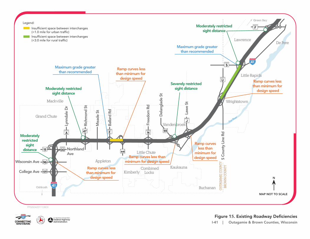
Figure 15. Existing Roadway DeficienciesI-41 | Outagamie & Brown Counties, Wisconsin
PPS0504201113BOI
96
125
COUNTY
OO15 NorthlandAve
Wisconsin Ave
College Ave
47
441
COUNTY
ACOUNTY
E
COUNTY
S
COUNTY
F
COUNTY
J
COUNTY
N55
Green Bay
Little Rapids
LawrenceDe Pere
COUNTY
U
Wrightstown
Fox Rive
r
Little Chute
Vandenbroek
Buchanan
CombinedLocks
KaukaunaKimberly
Appleton
BRO
WN
CO
UN
TY
OU
TAG
AM
IE C
OU
NTY
S C
ount
y Li
ne R
d
Law
e St
Del
angl
ade
St
Oshkosh
Mackville
Free
dom
Rd
Bal
lard
Rd
Mea
de S
t
Rich
mon
d St
Lynn
dale
Dr
Grand Chute
Legend:
Insufficient space between interchanges(<1.0 mile for urban traffic)Insufficient space between interchanges(<3.0 mile for rural traffic)
MAP NOT TO SCALE
N
Moderately restrictedsight distance
Severely restrictedsight distanceModerately restricted
sight distance
Moderatelyrestricted
sightdistance
Ramp curves lessthan minimum for
design speed
Ramp curves less than minimum for
design speed
Ramp curves lessthan minimum for
design speed
Ramp curves less thanminimum for design speed
Ramp curvesless than
minimum for design speed
Maximum grade greaterthan recommended
Maximum grade greaterthan recommended
Page 39
Written Testimony Form I-41– WIS 96 to County F Public Hearing – Environmental Assessment July 27, 28, and 29, 2021 Please place this form in the box on the comment table or mail by August 6, 2021. If returning by mail, self-addressed envelopes are available at the sign in table for your use.
Name (please print): ________________________________________________ Date: ____________
Address: _________________________________________________________________________________
Phone Number (optional): __________________ E-mail Address (optional): _________________________
Testimony (use additional pages if necessary):

Page 40
Page 41
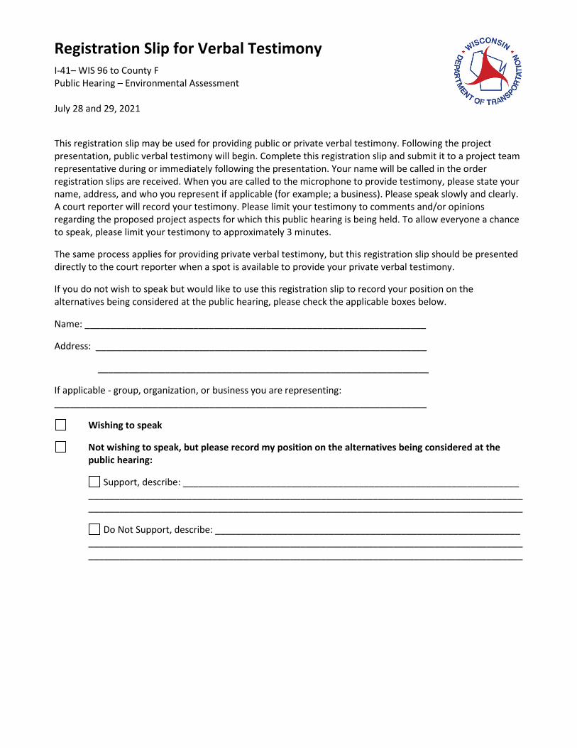
Registration Slip for Verbal Testimony I-41– WIS 96 to County F Public Hearing – Environmental Assessment July 28 and 29, 2021
This registration slip may be used for providing public or private verbal testimony. Following the project presentation, public verbal testimony will begin. Complete this registration slip and submit it to a project team representative during or immediately following the presentation. Your name will be called in the order registration slips are received. When you are called to the microphone to provide testimony, please state your name, address, and who you represent if applicable (for example; a business). Please speak slowly and clearly. A court reporter will record your testimony. Please limit your testimony to comments and/or opinions regarding the proposed project aspects for which this public hearing is being held. To allow everyone a chance to speak, please limit your testimony to approximately 3 minutes.
The same process applies for providing private verbal testimony, but this registration slip should be presented directly to the court reporter when a spot is available to provide your private verbal testimony.
If you do not wish to speak but would like to use this registration slip to record your position on the alternatives being considered at the public hearing, please check the applicable boxes below.
Name: __________________________________________________________________
Address: ________________________________________________________________
________________________________________________________________
If applicable - group, organization, or business you are representing: ________________________________________________________________________
Wishing to speak
Not wishing to speak, but please record my position on the alternatives being considered at the public hearing:
Support, describe: _________________________________________________________________ ________________________________________________________________________________________________________________________________________________________________________
Do Not Support, describe: ___________________________________________________________ ________________________________________________________________________________________________________________________________________________________________________