Embed Size (px)
Citation preview

Integrity – Service – Excellence
Headquarters U.S. Air Force
DoD Space Weather Activities Partnerships and Program Update
Lt Col Christopher Smithtro Commander, 16th Weather Squadron
Air Force Weather Agency
1

I n t e g r i t y - S e r v i c e - E x c e l l e n c e
Overview
The Challenge
DoD Space Wx Services
Space Weather Data Collection & Forecasting
Way Ahead
AFW-WEBS Demo
2

I n t e g r i t y - S e r v i c e - E x c e l l e n c e
The Challenge for All of Us
Space Weather is a “Total Team Sport”… From Research to Ops Expand collection capabilities:
Ground-Based: Optical, Radio, Magnetic, and Ionospheric Space-Based: Ionospheric, Magnetosphere, Solar Wind, &
Radiation Belt Solve the tough forecasting problems:
Physics-based model improvements Move from now-casts to “true” forecasts … easier said than done!
Deliver Ops Focused Exploitation Tools: An operational imperative to rapidly respond to the “Solar Threat”
of the day Must be easily understood and operationally relevant An absolute must if we are to move science into operations and
protect our Nation’s valued assets and technologies
3
Team, Sense, Forecast, and Exploit…the Way Forward

I n t e g r i t y - S e r v i c e - E x c e l l e n c e
AFWA’s 2nd Weather Squadron Space Weather Flight (DoD’s Space WX Providers)
Department of Defense Users
Environmental Inputs (DoD, Civil, International)
DoD Space Weather Services 40+ Years Providing Support for Warfighters
4
Space Weather Prediction Center
Key Partnerships
Data Received/Models Run
All Levels of Support
Air Force Research
Laboratory
Naval Research Laboratory
Community Coordinated
Modeling Center

I n t e g r i t y - S e r v i c e - E x c e l l e n c e
Exploit Current Capabilities • DMSP, GOES, POES, SOHO, ACE • STEREO, SDO, COSMIC & C/NOFS • Non-traditional sources Future • DSCOVR (ACE Follow-on) • COSMIC-II • AMPERE • Radiation Belt Storm Probe • Non-traditional sources
Advocacy and Partnering • Need partnerships to collect from the space domain! • CSESMO … proposed national space-based sensing architecture
Space Weather Space-Based Sensing
5

I n t e g r i t y - S e r v i c e - E x c e l l e n c e
Space Weather Ground-Based Sensing
AF and other agencies collect space weather data from ground-based sensors
SOON
DISS
6
Sensors include SOON, RSTN, DISS, NEXION, SCINDA Data from many government & non-government sources, USGS
Magnetometer, TEC (JPL), GONG, NGDC and others … Data partnerships are crucial
RSTN
ISOON
GONG
NEXION

I n t e g r i t y - S e r v i c e - E x c e l l e n c e 7
Investing in a Global Observing Network
SAGAMORE HILL
KAENA POINT
SAN VITO
LEARMONTH
KIRTLAND
ISOON ONLY ISOON / RADIO
RSTN (RADIO) ONLY RESEARCH ISOON GONG
TEIDE UDAIPUR
BIG BEAR
CERRO TOLOLO
MAUNA LOA
Improved Solar Optical Observing Network • Upgrades/remoting finished by 2017 Global Oscillation Network Group Radio Solar Telescope Network • Remoting finished by 2015

I n t e g r i t y - S e r v i c e - E x c e l l e n c e
DPS-‐4D Processor
4 Rx Antennas Tx Antenna
Next Generation Ionosonde NEXION
NIPRNet
IONOSPHERE
AFWA SWAFS GAIM
Replacement for Digital Ionospheric Sounding System (DISS) Ionospheric data feeds AFWA’s ionospheric model Generates products critical to space situational
awareness Advantages
Reduced footprint -- 5 acres for DISS/1 acre for NEXION Characterizes ionosphere over 1000 km radius Improved spatial resolution Modernized network and remote sustainment functions
NEXION network will consist of at least 30 sites New acquisition contract in place; install 3 sites per year:
worldwide fielding
AFWA Space Weather Flight Users
Partners: UMass - Lowell, SMC
I n t e g r i t y - S e r v i c e - E x c e l l e n c e
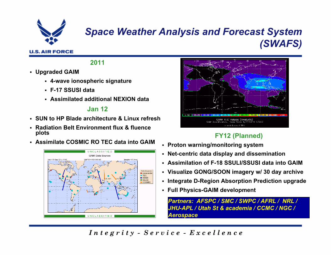
Space Weather Analysis and Forecast System (SWAFS)
2011 Upgraded GAIM
4-wave ionospheric signature F-17 SSUSI data Assimilated additional NEXION data
Jan 12 SUN to HP Blade architecture & Linux refresh Radiation Belt Environment flux & fluence
plots Assimilate COSMIC RO TEC data into GAIM
FY12 (Planned)
Partners: AFSPC / SMC / SWPC / AFRL / NRL / JHU-APL / Utah St & academia / CCMC / NGC / Aerospace
Proton warning/monitoring system Net-centric data display and dissemination Assimilation of F-18 SSULI/SSUSI data into GAIM Visualize GONG/SOON imagery w/ 30 day archive Integrate D-Region Absorption Prediction upgrade Full Physics-GAIM development

I n t e g r i t y - S e r v i c e - E x c e l l e n c e
Global Assimilation of Ionospheric Measurements (GAIM) Model Provides 24-hour forecast of ionospheric conditions Follow-on “full physics” upgrade planned for FY14 Output used for HF communication and geolocation error analysis
Space Weather Analysis and Forecasting
Estimated GPS Error Maps HF Illumination Maps
AFW provides space environmental data, analyses, forecasts, model output, and critical strategic-level
products to the warfighter!
Ionospheric Impacts
10

I n t e g r i t y - S e r v i c e - E x c e l l e n c e
Air Force Weather Web Services (AFW-WEBS)
11
Space weather products in a GIS/Google Earth format

I n t e g r i t y - S e r v i c e - E x c e l l e n c e
Space Weather Mission Support Way Ahead
Must team for solar max … and beyond Plans in place to improve collection, forecasting, & exploitation OFCM, NOAA, NASA, DoD, and other National Partners working together
… e.g. National Space Wx Program Council Integrated Action Plan Collaborate with U.S. & Allied government/civilian agencies to increase
sensing capability & reduce costs… NASA, NOAA, NSF, USGS, LANL, and others
Invest in collection… Modernize ground- and space-based sensing capabilities
Support national space wx forecasting needs Physics-based, “true” forecasting
Ensure exploitation of space wx expertise for situational awareness in the future Tailor products to specific missions and operational needs Develop expertise/knowledge among operators and space weather
professionals through training
12
Team, Sense, Forecast, and Exploit…the Way Forward

I n t e g r i t y - S e r v i c e - E x c e l l e n c e
AF Partnership with CCMC
Teaming is essential
Joint advocacy for new sensor capabilities
Model transition from research to ops
Collaborative research/V&V
New visualization and training tools
13

I n t e g r i t y - S e r v i c e - E x c e l l e n c e
Headquarters U.S. Air Force
14
Questions?
Operations
Research & Development
Acquisition
Customers
Rising Sun Over Pyramid (painting) – Paul Greco, 2009
Working with National Partners to support National Space Wx needs