Embed Size (px)
Citation preview
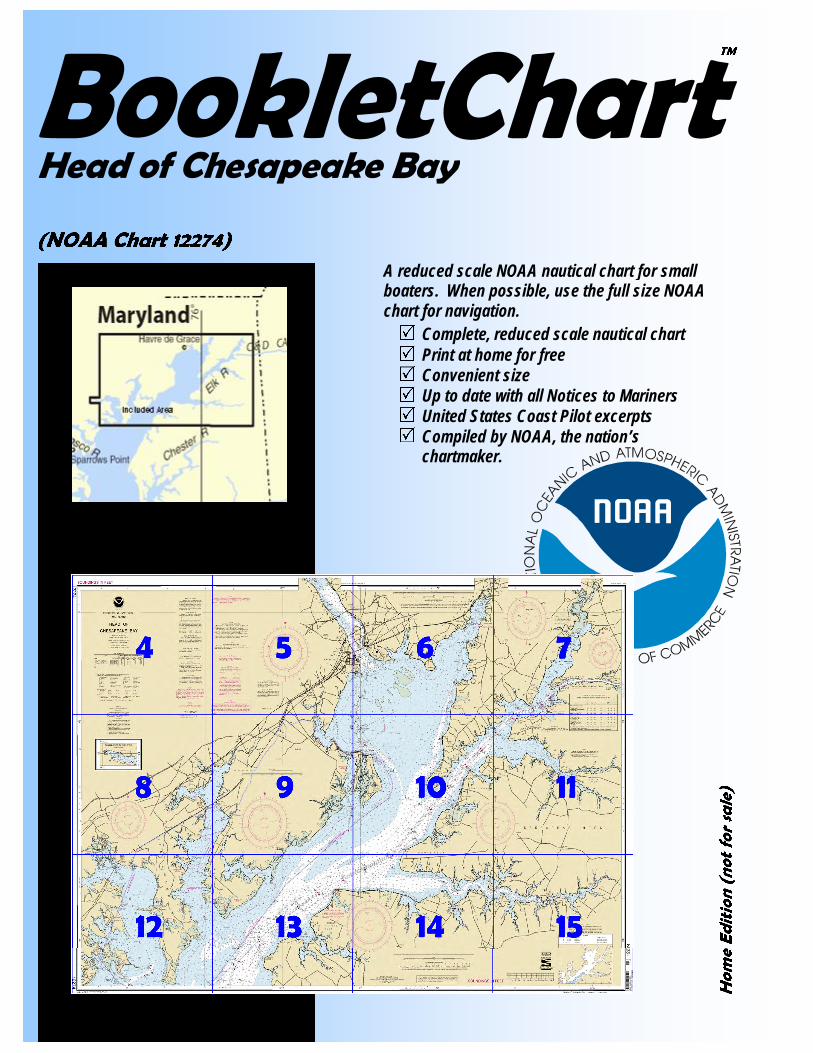
BookletChart
A reduced scale NOAA nautical chart for small boaters. When possible, use the full size NOAA
chart for navigation.� Complete, reduced scale nautical chart � Print at home for free � Convenient size � Up to date with all Notices to Mariners � United States Coast Pilot excerpts � Compiled by NOAA, the nation’s
chartmaker.
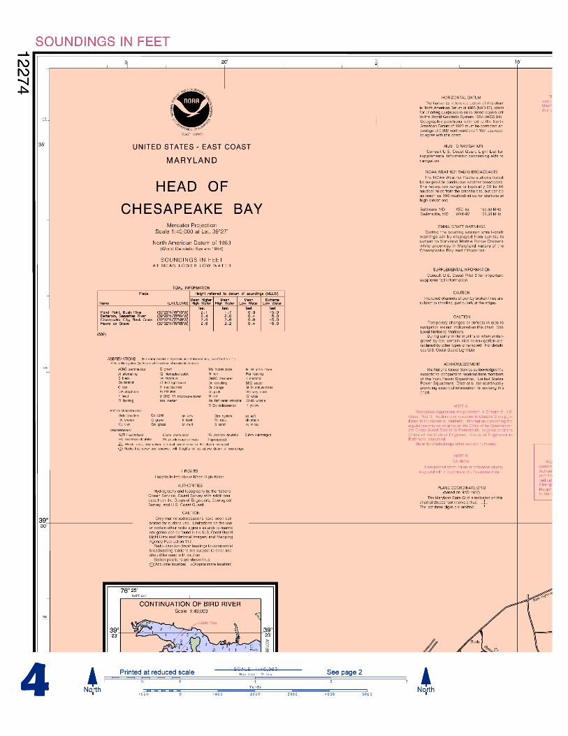
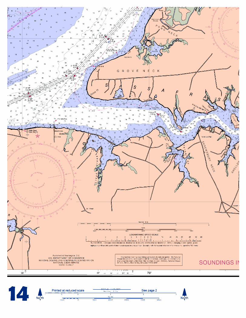
Head of Chesapeake Bay
(NOAA Chart 12274)
™
Home Edition (not for sale)
National
Nautical cshow water demuch more. Tefficient navigships that carryand Coast Gucarried by recr
This Boothemselves onbut otherwise cThe bar scalesmeasure distanofficial, full scsales agents are
The chart
62% of origina
This Bookregulated comFederal Regula
This Booin the U.S. Geospatial IntMariners, and,Mariners. Adadvance of theMariners appli
Coast Guard LNGA Weekly NCanadian Coas
Ground are cloduring specifie(199) Bush RGround constit
Published by Oceanic and Atmospheric Administration
National Ocean Service Office of Coast Survey
www.NauticalCharts.noaa.gov 301-713-2770
What are Nautical Charts?
harts are a fundamental tool of marine navigation. They pths, obstructions, buoys, other aids to navigation, and he information is shown in a way that promotes safe and ation. Chart carriage is mandatory on the commercial America’s commerce. They are also used on every Navy ard ship, fishing and passenger vessels, and are widely eational boaters.
What is a BookletChart™?
kletChart is made to help recreational boaters locate the water. It has been reduced in scale for convenience, ontains all the information of the full-scale nautical chart. have also been reduced, and are accurate when used to ces in this BookletChart. Whenever possible, use the ale NOAA nautical chart for navigation. Nautical chart listed at: http://www.NauticalCharts.noaa.gov.
s and bar scales in this BookletChart have been reduced to l scale, and are printed at the new scale of 1:64,516.
letChart does NOT fulfill chart carriage requirements for mercial vessels under Titles 33 and 44 of the Code of tions.
Notice to Mariners Correction Status
kletChart has been updated for chart corrections published Coast Guard Local Notice to Mariners, the National elligence Agency (formerly NIMA) Weekly Notice to where applicable, the Canadian Coast Guard Notice to ditional chart corrections have been made by NOAA in ir publication in a Notice to Mariners. The last Notices to ed were:
ocal Notice to Mariners: 28/05 July 12, 2005 otice to Mariners: 29/05 July 16, 2005
t Guard Notice to Mariners: Not Applicable
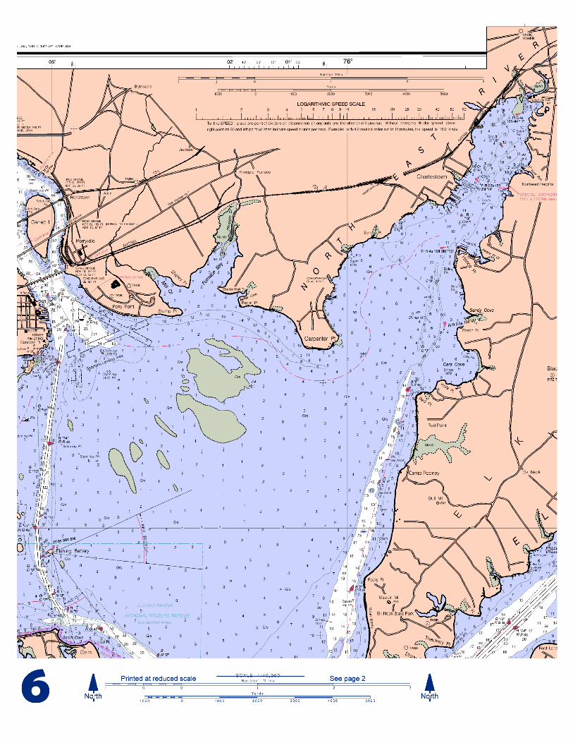
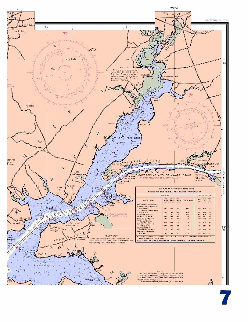
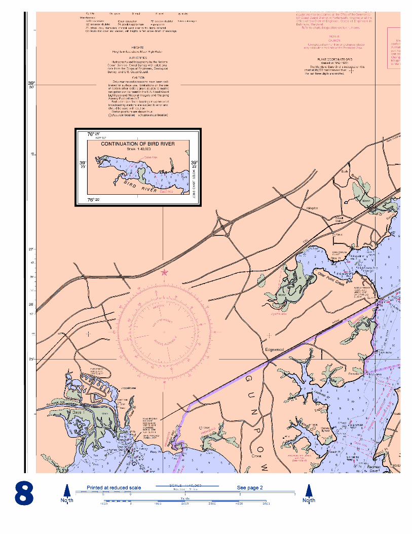
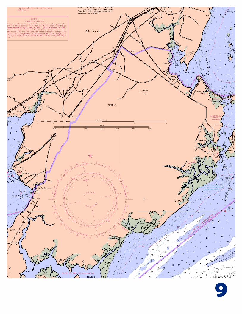
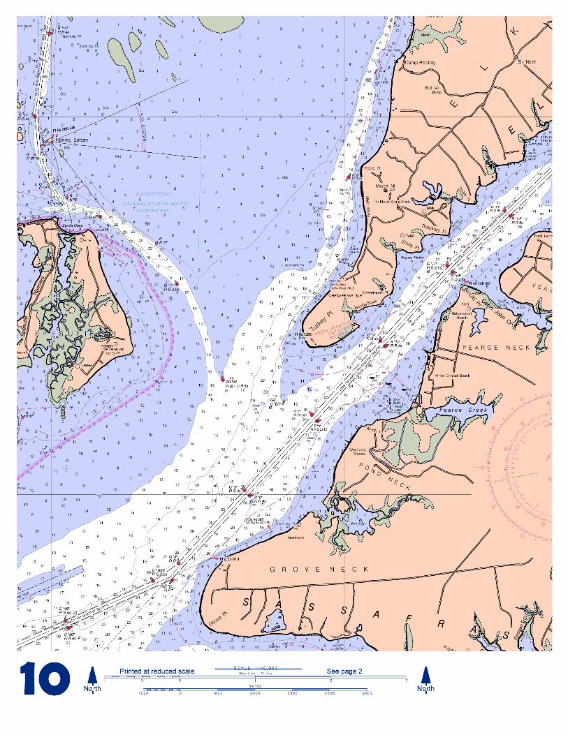
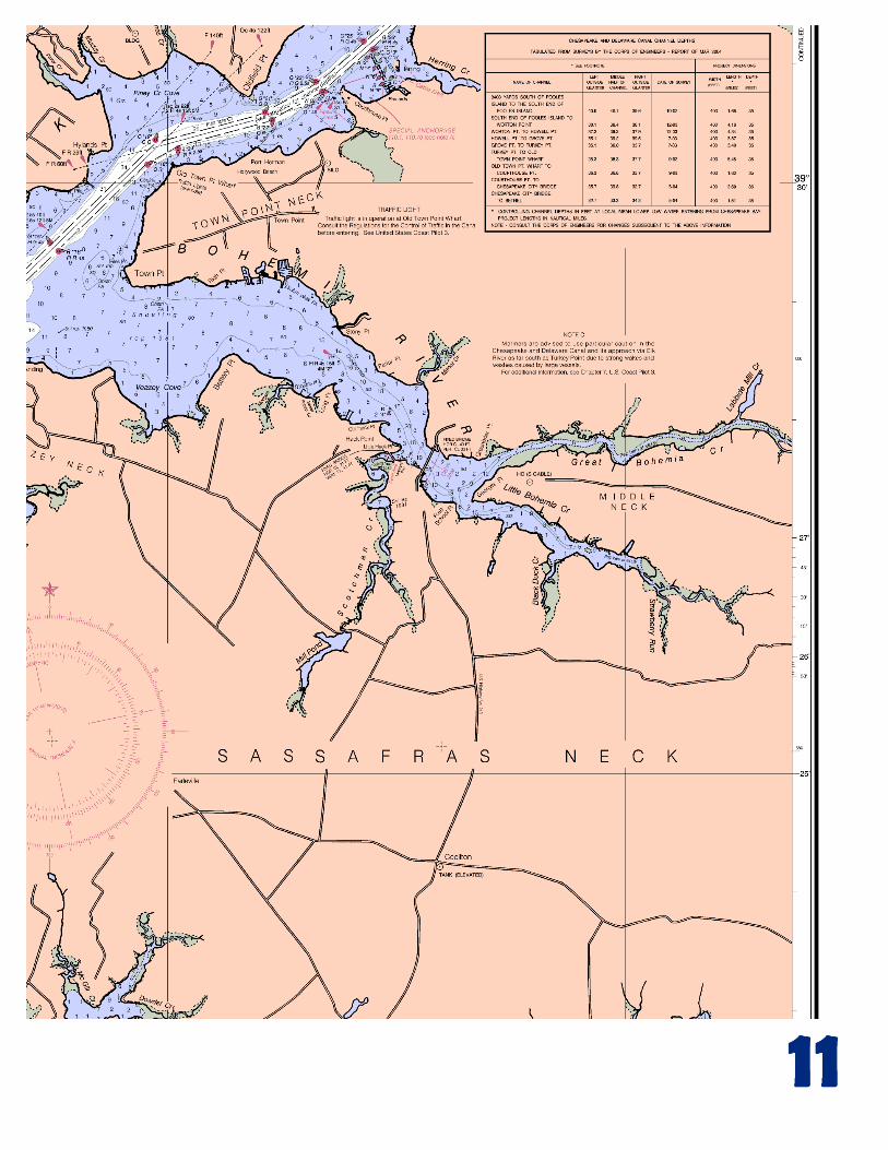
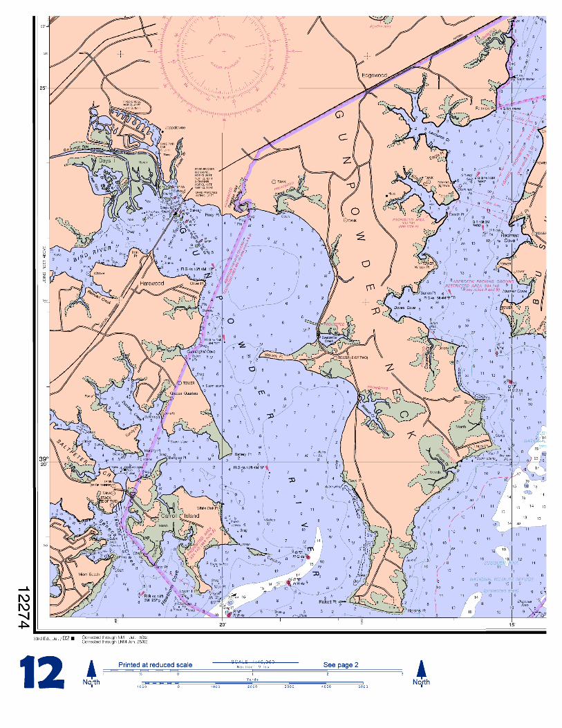
[Coast Pilot 3, Chapter 15 excerpts] (192) Gunpowder River is entered through a channel marked by a light and buoys west of Spry Island Shoal; the shoal is covered 2 to 4 feet; the channel had depths of 8 feet for 2 miles; 2 to 9 feet for 4 miles; 3 feet in a channel leading to a creek below Joppatowne, with depths of 4 to 7 feet and 4 feet in the marina basin. (194) Marinas above the bridge have slips, gasoline, and marine supplies. (196) Some waters of the Aberdeen Proving
sed to the public at all times. Others have a limited access d hours. iver. The lower 5 miles are within Aberdeen Proving uting prohibited land areas and restricted and dangerou
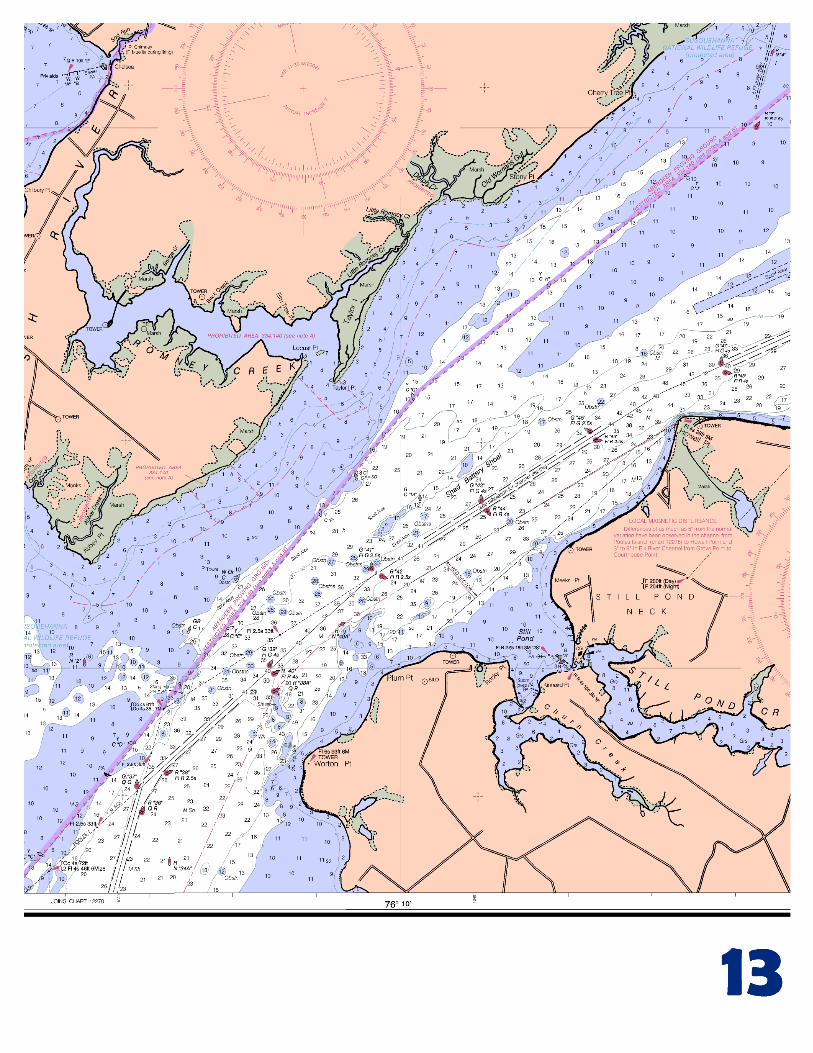
water areas. (200) The river has depths of 7 feet to the railroad bridge 6.3 miles above the mouth, thence 5 to 6 feet for another 1.5 miles. The approach to the river and the channel are marked by buoys and a light as far as Tapler Point, and by a light on the east side 0.3 mile south of the railroad bridge, which shows a high-intensity beam down river; the lower light, off the western shore about 2.7 miles above the mouth shows high-intensity beams up and down river. (204) Still Pond has depths of 9 to 11 feet and is a good anchorage during easterly winds. Churn Creek has depths of 2 feet in the entrance and deeper water inside. (205) Stillpond Creek is entered through a narrow channel; the depth was 7½ feet through the entrance. A light and buoys mark the entrance. The channel inside Stillpond Creek is marked by a daybeacon and buoys. (206) Stillpond Coast Guard Station is on the north side of the entrance to Stillpond Creek. (207) Sassafras River. The entrance is between Howell Point and Grove Point. The river is used by vessels drawing up to 12 feet. (208) The river channel has depths of 13 feet to a point 1 mile above the U.S. Route 213 bridge, thence 7 to 3 feet for 2 miles. The channel is marked as far as the highway bridge. (212) Fredericktown and Georgetown are connected by a bridge that has a clearance of 5 feet. The bridgetender monitors VHF-FM channel 16 and works on channels 13 and 68; call sign KYU-699. The speed limit is 6 miles per hour in Sassafras River 0.5 mile above and below the bridge. (213) There are facilities on both sides of the river below the bridge. Berthing, electricity, water, gasoline, diesel fuel, and marine supplies can be obtained. (215) Spesutie Narrows. A channel leads from the flats off the southern entrance to a basin at Mulberry Point; the depth was 5 feet to the basin with 2½ to 5 feet at the landings. The entrance channel is marked by buoys and lighted ranges; the inner channel is marked by daybeacons. (217) Spesutie Island and Spesutie Narrows are within Aberdeen Proving Ground constituting prohibited land areas and restricted and dangerous water areas. (219) Mariners are required to observe the speed regulation in Elk River, Back Creek, and Chesapeake and Delaware Canal. (221) The current velocity is 0.8 knot. (223) Bohemia River has depths of 7 feet or more for 4 miles to the junction of Great Bohemia Creek and Little Bohemia Creek; 6 to 4 feet for 1.5 miles in Great Bohemia Creek; 7 feet for 1 mile in Little Bohemia Creek. (224) The cove on the southwest side of Bohemia River 3 miles above the entrance has depths of 3 to 5 feet and is a small-boat anchorage. (225) The speed limit is 6 miles per hour from the highway bridge to 1 mile downstream in Bohemia River. (226) There are small-craft facilities along the north side of Bohemia River and along the south side of the river below the bridge. (229) Above Back Creek, the channel in Elk River is marked by buoys to Locust Point. Depths vary considerably, ranging from 10 feet at the south end to 1 foot off Locust Point. In 1978, a depth of 1 foot was in the channel above Locust Point. (230) Small-craft facilities are on Elk River 5 miles above Old Town Point Wharf. (235) Susquehanna River. A marked channel leads through the flats from Chesapeake Bay to Havre de Grace. A side channel leads to a basin at City Park at Havre de Grace; the depth was 12 feet. In 1990, a controlling depth of 2 feet (5½ feet at midchannel) was in the side channel and 4½ feet in the basin at City Park (240) There are berthing and repair facilities at Havre de Grace. (241) Perryville has berthing facilities above the first bridge. Gasoline and marine supplies are available. (242) Above Havre de Grace, depths of 13 feet to 50 feet are in the channel of the Susquehanna River to Port Deposit; the river is obstructed by rocks above here. (243) Garrett Island. The favored channel is west of the island; rocks, shoals, logs, and submerged pilings in this area. (244) Port Deposit. Gasoline and some supplies are available.
2s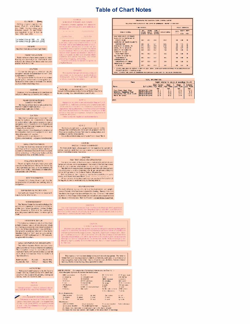

VHF Marine Radio channels for use on the waterways: Channel 6 – Intership safety communications. Channel 9 – Communications between boats and ship-to-coast. Channel 13 – Navigation purposes at bridges, locks, harbors. Channel 16 – Emergency, distress and safety calls to Coast Guard and others, and to initiate calls to other vessels. Contact the other vessel, agree to another channel, and then switch. Channel 22 – Calls between the Coast Guard and the public. Severe weather warnings, hazards to navigation and safety warnings are broadcast here. Channels 68, 69, 71, 72 & 78 – Recreational boat channels.
Distress Call Procedures
1. Make sure radio is on. 2. Select Channel 16. 3. Press/Hold the transmit button. 4. Clearly say: “MAYDAY, MAYDAY, MAYDAY.” 5. Also give: Vessel Name and/or Description; Position
and/or Location; Nature of Emergency; Number of People on Board.
6. Release transmit button. 7. Wait for 10 seconds – If no response Repeat
MAYDAY Call. HAVE ALL PERSONS PUT ON LIFE JACKETS !!
Mobile Phones – Call 911 for water rescue. Coast Guard Search & Rescue – 800-418-7314/410-576-2525
Coast Guard Annapolis – 410-267-8108 Coast Guard Little Creek – 757-464-9371/9372 Coast Guard Stillpond – 410-778-2201-2202 Maryland Natural Resources Police – 410-260-8888
NOAA Weather Radio – 162.400 MHz, 162.425 MHz, 162.450 MHz, 162.475 MHz, 162.500 MHz, 162.525 MHz, 162.550 MHz. Getting and Giving Help – Signal other boaters using visual distress signals (flares, orange flag, lights, arm signals); whistles; horns; and on your VHF radio. You are required by law to help boaters in trouble. Respond to distress signals, but do not endanger yourself.
EMERGENCY INFORMATION NOAA CHARTING PUBLICATIONS
NOAA, the Natio
Official NOAA Nautical Charts – NOAA surveys and charts the national and territorial waters of the U.S, including the Great Lakes, producing over 1,000 traditional nautical charts covering 3.4 million square nautical miles. Carriage of official NOAA charts is mandatory on the commercial ships that carry our commerce. They are used on every Navy and Coast Guard ship, fishing and passenger vessels, and are widely carried by recreational boaters. NOAA charts are available from official chart agents listed at: www.NauticalCharts.NOAA.gov.
Official Electronic Navigational Charts® (ENCs) – ENCs are digital files of each chart’s features and their attributes for use in computer-based navigation systems. ENCs comply with standards of the International Hydrographic Organization. ENCs and their updates are available for free from NOAA at: www.NauticalCharts.NOAA.gov.
Official Raster Navigational Charts (RNCs) – RNCs are georeferenced digital pictures of NOAA’s charts that are suitable for use in computer-based navigation systems. RNCs comply with standards of the International Hydrographic Organization. RNCs and their updates are available for free from NOAA at: www.NauticalCharts.NOAA.gov.
Official BookletCharts™ - BookletCharts™ are reduced scale NOAA charts printed in page-sized pieces. The “home edition” can be downloaded from NOAA for free and printed. The “professional edition”, containing additional boating, safety, and educational edition is available for NOAA chart agents or over the Internet.
Official PocketCharts™ – PocketCharts™ are for beginning recreational boaters to use for planning and locating, but not for real navigation. Measuring a convenient 13” by 19”, they have a 1/3 scale chart on one side, and safety, boating, and educational information on the reverse. They can be purchased at retail outlets and on the Internet.
Official U.S. Coast Pilot® – The Coast Pilots are 9 text volumes containing information important to navigators such as channel descriptions, port facilities, anchorages, bridge and cable clearances, currents, prominent features, weather, dangers, and Federal Regulations. They supplement the charts and are available from official NOAA chart agents or downloaded for free at: www.NauticalCharts.NOAA.gov.
Official Print-on-Demand Nautical Charts – These full-scale NOAA charts are updated each week by NOAA for all Notice to Mariner corrections. They have additional information added in the margin to supplement the chart. Print on Demand charts meet all federal chart carriage regulations for charts and updating. Produced under a public/private partnership between NOAA and OceanGrafix, LLC, suppliers of these premium charts are listed at www.OceanGrafix.com.
Official Chart No. 1, Nautical Chart Symbols – This reference publication depicts basic chart elements and explains nautical chart symbols and abbreviations. Download it for free at: www.NauticalCharts.NOAA.gov.
Coast Survey Navigation Managers – These ambassadors to the maritime community maintain a regional presence for NOAA and help identify the challenges facing marine transportation and boating. They are listed at http://nauticalcharts.noaa.gov/nsd/reps.htm.
Internet sites: www.NauticalCharts.NOAA.gov, www.NOAA.gov, www.TidesandCurrents.NOAA.gov, www.NOS.NOAA.gov.
n’s Chartmaker