Embed Size (px)
Citation preview

HUMBOLDT BAY Sea Level Rise Adaptation Planning Project:
Phase II Report
Prepared By
Aldaron Laird Trinity Associates
February 2015

HUMBOLDT BAY SEA LEVEL RISE ADAPTATION PLANNING PROJECT
Trinity Associates 2015 2
Acknowledgements
Funding by: California Coastal Conservancy
Sponsored by: Coastal Ecosystems Institute of Northern California
Adaptation Planning Working Group Co-Lead Agencies:
Humboldt Bay Harbor Conservation, and Recreation District Humboldt County Public Works Department (Environmental Services Division)
Sea Level Rise Adaption Planning Consultant: Trinity Associates
Humboldt Bay Sea Level Rise Hydrodynamic Modeling and Inundation Vulnerability Mapping: Northern Hydrology and Engineering
Note: This report was prepared by Trinity Associates and does not necessarily reflect the views of the agencies and organizations that participated in the Humboldt Bay Sea Level Rise Adaptation Planning Group.

HUMBOLDT BAY SEA LEVEL RISE ADAPTATION PLANNING PROJECT
Trinity Associates 2015 3
TABLE OF CONTENTS
EXECUTIVE SUMMARY ................................................................................................. 4
INTRODUCTION ............................................................................................................. 5
BACKGROUND .............................................................................................................. 6
Tidal Datums ............................................................................................................... 6
Previous Studies and Available Data ........................................................................... 7
1. Humboldt Bay Shoreline Inventory, Mapping, and Sea Level Rise Vulnerability Assessment ............................................................................................................. 8
2. Humboldt Bay Sea Level Rise Hydrodynamic Modeling and Inundation Maps ... 9
3. Humboldt Bay Sea Level Rise Adaptation Planning Working Group ................. 10
SEA LEVEL RISE ADAPTATION PLANNING PROCESS: HOW, WHERE, WHEN, WHAT, AND WHO .................................................................................................. 11
Vulnerability Assessment ........................................................................................... 12
1. How Will Sea Level Rise Impact Humboldt Bay? .............................................. 12
2. Where Will Sea Level Rise Impact Humboldt Bay? ........................................... 12
3. When Will Sea Level Rise Impact Humboldt Bay? ............................................ 17
4. What Will Sea Level Rise Impact on Humboldt Bay? ........................................ 18
Adaptation Planning ................................................................................................... 21
Adaptation Strategies ............................................................................................. 23
5. Who Will Address Sea Level Rise Impacts on Humboldt Bay? ......................... 23
Urban Areas ........................................................................................................... 26
Coastal Resources ................................................................................................. 27
Utilities ................................................................................................................... 28
Transportation Systems ......................................................................................... 28
CONCLUSIONS & RECOMMENDATIONS .................................................................. 28
REFERENCES .............................................................................................................. 31
APPENDIX A: Can Agricultural Lands and Uses on Humboldt Bay Adapt to Sea Level Rise? ..................................................................................................................... A-1
APPENDIX B: How Can the Highway 101 Corridor on Humboldt Bay Adapt to Sea Level Rise? ..................................................................................................................... B-1
HUMBOLDT BAY SEA LEVEL RISE ADAPTATION PLANNING PROJECT
Trinity Associates 2015 4
EXECUTIVE SUMMARY
Humboldt Bay Sea Level Rise Adaptation Planning Project (hereafter Project) is a multi-phased regional collaboration funded by the California State Coastal Conservancy. Its purpose is to inform the public and local agencies of the risk that sea level rise poses to the communities and environment on Humboldt Bay and examine the process of developing adaptation strategies and options for critical regional assets. Critical assets provide services necessary for the public’s health and safety or would affect large numbers of people or properties/business in the Humboldt Bay region if the asset were lost or impaired. Critical regional asset categories in the Humboldt Bay region are: urban areas, coastal resources (agricultural lands, seasonal freshwater wetlands, and wildlife habitats), utilities, and transportation infrastructure.
Expected sea level rise impacts on Humboldt Bay are tidal inundation and flooding: from shoreline breaching or overtopping, backwater effects in tributaries draining to Humboldt Bay, reduced efficiency of shoreline water control structures, rising groundwater, and lastly, salt water intrusion. Low-lying former tidelands that were separated from Humboldt Bay more than a century ago with the construction of dikes and railroad beds are at risk of future inundation by extreme tides, storms, El Niño events, and sea level rise due to existing shoreline conditions. Seventy-five percent (77 miles) of Humboldt Bay’s shoreline is artificial, predominately consisting of earthen dikes (41 miles) and railroad beds (11 miles); approximately 26 miles of artificial shoreline are rated highly vulnerable to breaching or being overtopped.
Since 1977, Humboldt Bay is subsiding and its average rate of relative sea level rise of 0.15 inches/year (15 inches per century) is greater than anywhere else in California. Relative sea level rise estimates have been prepared for the North Spit tide gage from 2000 to 2100, including low and high greenhouse gas emission scenarios. Sea level rise elevations that exceed what currently occurs on Humboldt Bay are expected by 2050. Inundation vulnerability maps show areas surrounding Humboldt Bay that are vulnerable to tidal inundation from existing and future sea levels, but that are currently protected by the natural shoreline, dikes, and railroad and/or road grades. There are 26.2 miles of highly vulnerable shoreline structures; if they are breached, the current tidal inundation footprint of Humboldt Bay (at MMMW) could expand by 52 percent (8,918 acres). Due to topographic constraints around Humboldt Bay, after the protective shoreline ceases to function due to breaching, sea level rise would incrementally increase the tidal footprint an average of 1,512 acres for each 0.5 meter rise in tide elevation.
During the Project, the Adaptation Planning Working Group (APWG) was convened, whose goal is to support informed decision-making and encourage unified consistent regional adaptation strategies to address the hazards associated with sea level rise in the Humboldt Bay region. The APWG utilized two critical assets as case studies, agricultural lands (Appendix A) and Highway 101 (Appendix B), to explore a regional approach to adaptation planning on Humboldt Bay. These assets were evaluated extensively by way of a sea level rise impact risk analysis that entails assessing an asset’s exposure, sensitivity, and significance.
HUMBOLDT BAY SEA LEVEL RISE ADAPTATION PLANNING PROJECT
Trinity Associates 2015 5
In general, adaptation strategies fall under several categorical approaches to address sea level rise impacts to assets at risk: (1) no action, (2) protect/defend, (3) accommodate/adapt, and (4) relocate/retreat. Education is an adaptation strategy that is common to all strategies and should be the first to be employed. Regardless of what approach is selected to adapt to sea level rise impacts, funding and regulatory flexibility are two critical issues that need to be addressed. Developing and implementing adaption strategies for assets at risk will require decades of planning, design, and implementation, as well as significant financial investments. Determining who owns, is responsible for, is dependent upon or uses the services provided by a critical asset at risk will likely identify who should be involved in selecting appropriate adaptation strategies, developing feasible adaptation options, and securing funds for implementing these options.
INTRODUCTION
Humboldt Bay Sea Level Rise Adaptation Planning Project (hereafter Project) is a multi-phased regional collaboration funded by the California State Coastal Conservancy. Its purpose is to inform the public and local agencies of the risk that sea level rise poses to the communities and environment on Humboldt Bay and examine the process of developing adaptation strategies and options for critical regional assets. The adaptation strategies presented in this report represent a starting point from which stakeholders may develop plans for dealing with impending sea level rise on Humboldt Bay.
Phase I of the Project was led by Trinity Associates and involved gathering baseline data on shoreline vulnerability. This phase included the Humboldt Bay Shoreline Inventory, Mapping, and Sea Level Rise Vulnerability Assessment report and addendum, which described current shoreline conditions and identified shoreline segments vulnerable under current conditions to breaching or overtopping. It also identified land uses and infrastructure potentially at risk from tidal inundation (Laird and Powell 2013).
Phase II of the Project is sponsored by the Coastal Ecosystems Institute of Northern California, and includes three components: (1) preparation of Humboldt Bay Sea Level Rise Hydrodynamic Modeling and Inundation Vulnerability Maps prepared by Northern Hydrology and Engineering (NHE 2014c); (2) formation of a Humboldt Bay Sea Level Rise Adaptation Planning Working Group (APWG), convened by Humboldt Bay Harbor, Conservation, and Recreation District and Humboldt County Public Works Department as co-lead agencies; and (3) preparation of this report, the Humboldt Bay Sea Level Rise Adaptation Plan by Trinity Associates. A brief summary of Phase I and II activities and products used to prepare this report are described in the Background section below.
This report summarizes the APWG’s exploration of the: how, where, when, what, and who of adaptation planning on Humboldt Bay. This report also presents in-depth adaptation planning case studies for two critical regional assets that are at risk from sea level rise: agricultural lands and uses (Appendix A) and the Highway 101 corridor (Appendix B). Lastly, this report will close with recommendations on next steps to build
HUMBOLDT BAY SEA LEVEL RISE ADAPTATION PLANNING PROJECT
Trinity Associates 2015 6
on the APWG’s regional collaboration to develop and implement adaptation options while engaging the public and affected property owners.
BACKGROUND
This section will present important information relevant to the following discussion of sea level rise, including tidal datums, previous studies, and available data.
Tidal Datums
There are a variety of different reference points, or tidal datums, used to measure tidal elevation, depending on the particular tidal phase of interest and on the type of tides present along a shoreline (NOAA 2001). A typical tidal cycle involves two high tides and two low tides within a single cycle. On Humboldt Bay, the two high tides are not equivalent; one is higher than the other. The same is true for the low tides. These types of mixed tidal cycles result in tidal datums such as mean lower low water (MLLW) and mean higher high water (MHHW). Other recognized tidal datums include mean low water (MLW), mean sea level (MSL), mean high water (MHW, considered representative of the shoreline), and mean annual maximum water (MAMW, also known as king tides, Table 1). Because sea level is expected to rise in the future in response to climate change, the tidal datum against which sea levels are referenced must be consistent.
This Project has utilized mean monthly maximum water (MMMW (7.74 feet)) as the tidal base elevation to assess shoreline vulnerability and to depict areas that would be vulnerable to tidal inundation should the existing shoreline protection be breached. While not an official tidal datum, MMMW was selected because on Humboldt Bay, the tidal boundary is closely associated with the MMMW elevation on natural shorelines. All elevations in this report are NAVD 88. The bay-wide 100-year extreme event stillwater level is 26.97 inches (2.25 feet) higher than the bay-wide average MMMW (NHE 2014a).
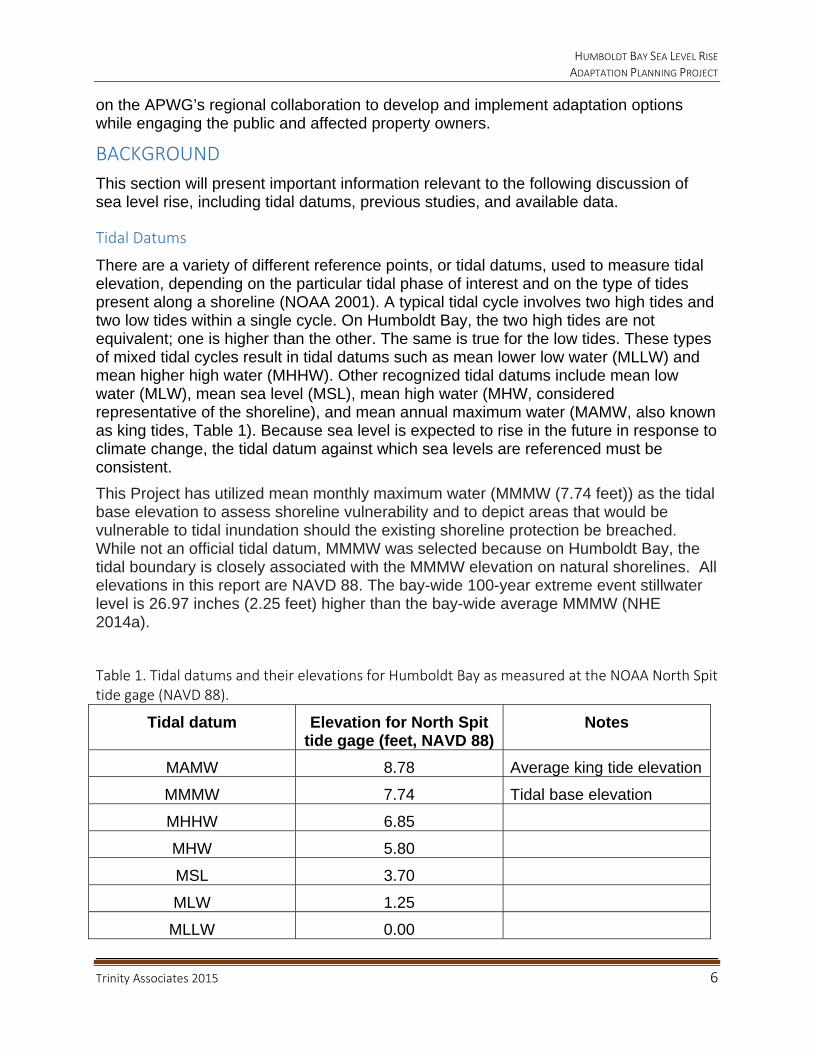
Table 1. Tidal datums and their elevations for Humboldt Bay as measured at the NOAA North Spit tide gage (NAVD 88).
Tidal datum Elevation for North Spit tide gage (feet, NAVD 88)
Notes
MAMW 8.78 Average king tide elevation
MMMW 7.74 Tidal base elevation
MHHW 6.85
MHW 5.80
MSL 3.70
MLW 1.25
MLLW 0.00
HUMBOLDT BAY SEA LEVEL RISE ADAPTATION PLANNING PROJECT
Trinity Associates 2015 7
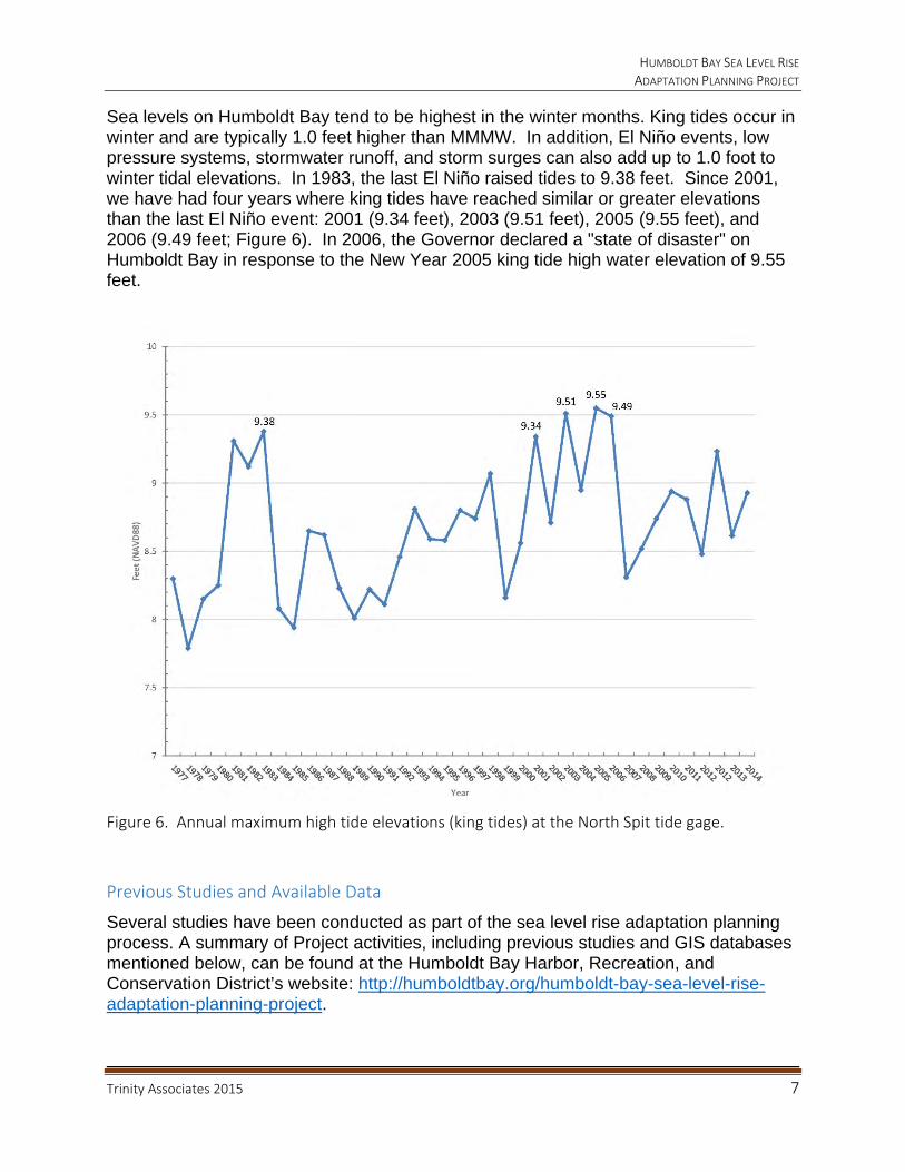
Sea levels on Humboldt Bay tend to be highest in the winter months. King tides occur in winter and are typically 1.0 feet higher than MMMW. In addition, El Niño events, low pressure systems, stormwater runoff, and storm surges can also add up to 1.0 foot to winter tidal elevations. In 1983, the last El Niño raised tides to 9.38 feet. Since 2001, we have had four years where king tides have reached similar or greater elevations than the last El Niño event: 2001 (9.34 feet), 2003 (9.51 feet), 2005 (9.55 feet), and 2006 (9.49 feet; Figure 6). In 2006, the Governor declared a "state of disaster" on Humboldt Bay in response to the New Year 2005 king tide high water elevation of 9.55 feet.
Figure 6. Annual maximum high tide elevations (king tides) at the North Spit tide gage.
Previous Studies and Available Data
Several studies have been conducted as part of the sea level rise adaptation planning process. A summary of Project activities, including previous studies and GIS databases mentioned below, can be found at the Humboldt Bay Harbor, Recreation, and Conservation District’s website: http://humboldtbay.org/humboldt-bay-sea-level-rise-adaptation-planning-project.

HUMBOLDT BAY SEA LEVEL RISE ADAPTATION PLANNING PROJECT
Trinity Associates 2015 8
1. Humboldt Bay Shoreline Inventory, Mapping, and Sea Level Rise Vulnerability Assessment
The Humboldt Bay Shoreline Inventory, Mapping, and Sea Level Rise Vulnerability Assessment provided the first comprehensive evaluation of shoreline conditions (Laird and Powell 2013). Seventy-five percent (77 miles) of Humboldt Bay’s shoreline is artificial, predominately consisting of earthen dikes (53%, 41 miles) and railroad beds (14%, 11 miles). These two types of linear shoreline structures were constructed between 1890 and 1915, which today, more than a century later, are approximately 1.5 feet lower relative to current sea levels due to tectonic subsidence and global sea level rise (Russell and Griggs 2012). The dikes were built to hold back extreme high tides around the turn of the 20th century; those extreme high tide elevations are currently reached by our annual highest high tides (king tides) due to sea level rise and subsidence of land in and around Humboldt Bay (NHE 2014a). At this time, the railroad has not been used commercially for more than a decade and much of the railroad bed has not been maintained. This helps explain why so much of the diked and railroad beds shoreline is currently vulnerable to overtopping by high water level events from king tides, storm surges and stormwater runoff, low pressure systems, wind waves, and El Niño conditions.
The vulnerability of these shoreline structures is compounded by the fact that no single entity is responsible for improvement or maintenance. Approximately 26 miles of shoreline composed of dikes and railroad beds are rated highly vulnerable to breaching or being overtopped (Laird and Powell 2013; Figure 1).
The lands behind these shoreline structures are vulnerable to tidal inundation today if these structures breach or overtop. The former tidelands behind these shoreline structures have compacted due to oxidation of organic matter in the salt marsh soil and loss of sediment supply because these areas were cut-off from the daily tides; the region has also experienced tectonic subsidence resulting in these lands being as much as three feet lower than when they were salt marsh in the late 1800s/early 1900s. To illustrate the amount of lands behind these structures that are vulnerable: if all of these shoreline structures fail, the tidal footprint of Humboldt Bay could increase 52 percent. If water or tidal elevations rise 2.0 feet above the Mean Monthly Maximum Water (MMMW) elevation, then 11.4 miles of dikes could be overtopped; with 3.0 feet of sea level rise, 23.4 miles could be overtopped (Laird and Powell 2013). It is estimated that water levels could rise as much as 5.3 feet this century (NHE 2014a), which would overtop nearly all of the dikes (38.4 miles), if they are not raised beforehand. Development of the Humboldt Bay region in the past 100 years included construction of critical infrastructure on former tidelands protected by earthen shoreline structures, such as Highways 101 and 255, municipal and industrial water transmission lines, gas lines, and electrical transmission towers. If the protective shoreline structures fail, tidal inundation of the former tidelands and the critical infrastructure located on these lands could be disastrous to this region’s communities.
HUMBOLDT BAY SEA LEVEL RISE ADAPTATION PLANNING PROJECT
Trinity Associates 2015 9
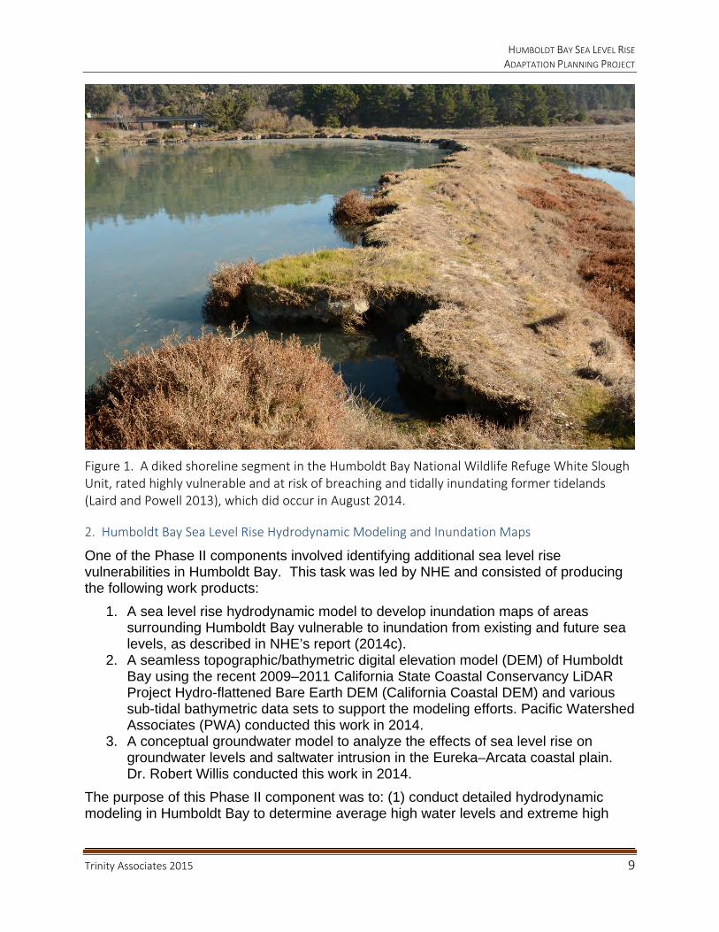
Figure 1. A diked shoreline segment in the Humboldt Bay National Wildlife Refuge White Slough Unit, rated highly vulnerable and at risk of breaching and tidally inundating former tidelands (Laird and Powell 2013), which did occur in August 2014.
2. Humboldt Bay Sea Level Rise Hydrodynamic Modeling and Inundation Maps
One of the Phase II components involved identifying additional sea level rise vulnerabilities in Humboldt Bay. This task was led by NHE and consisted of producing the following work products:
1. A sea level rise hydrodynamic model to develop inundation maps of areas surrounding Humboldt Bay vulnerable to inundation from existing and future sea levels, as described in NHE’s report (2014c).
2. A seamless topographic/bathymetric digital elevation model (DEM) of Humboldt Bay using the recent 2009–2011 California State Coastal Conservancy LiDAR Project Hydro-flattened Bare Earth DEM (California Coastal DEM) and various sub-tidal bathymetric data sets to support the modeling efforts. Pacific Watershed Associates (PWA) conducted this work in 2014.
3. A conceptual groundwater model to analyze the effects of sea level rise on groundwater levels and saltwater intrusion in the Eureka–Arcata coastal plain. Dr. Robert Willis conducted this work in 2014.
The purpose of this Phase II component was to: (1) conduct detailed hydrodynamic modeling in Humboldt Bay to determine average high water levels and extreme high
HUMBOLDT BAY SEA LEVEL RISE ADAPTATION PLANNING PROJECT
Trinity Associates 2015 10
water level event probabilities within the existing shoreline of Humboldt Bay for five sea level rise scenarios: Year 2012 existing sea levels and half-meter sea level rise increments of 0.5 (1.6 feet), 1.0 (3.3 feet), 1.5 (4.9 feet) and 2.0 m (6.6 feet), including low and high estimates and projected water levels resulting from sea level rise, and (2) develop inundation maps of areas surrounding Humboldt Bay that are vulnerable to tidal inundation from existing and future sea levels. The ultimate goal of this Phase II activity was to provide the APWG and general public information on how sea level rise may affect water levels in Humboldt Bay, including inundation vulnerability maps in a user-friendly format such as kmz files, which can be opened in Google Earth, and shapefiles, which can be imported into GIS software such as ArcGIS. (NHE 2014b). The inundation vulnerability maps show areas surrounding Humboldt Bay that are vulnerable to tidal inundation from existing and future sea levels, but that are currently protected from tidal inundation by the natural shoreline, dikes, and railroad and/or road grades. Although the inundation maps show areas vulnerable to inundation, not areas currently inundated, the maps can be used to illustrate when specific water levels associated with a sea level rise scenario may overtop a dike or barrier protecting a vulnerable area, which would allow tidal flooding, as well as the potential consequences of dike failures during current or future high tide events (NHE 2014c). It is important to note that inundation vulnerability maps are based on recent topographic conditions from 2010 LiDAR. Because surface topography is subject to change without knowing future conditions, it is somewhat theoretical to forecast which assets will be potentially at risk in 2050 or 2100.
3. Humboldt Bay Sea Level Rise Adaptation Planning Working Group
Another Phase II activity involved convening the APWG, whose goal is to support informed decision-making and encourage unified consistent regional adaptation strategies to address the hazards associated with sea level rise in the Humboldt Bay region. The two co-lead agencies for the APWG are the Humboldt County Public Works Department and the Humboldt Bay Harbor, Recreation, and Conservation District. Trinity Associates is the sea level rise adaptation planning consultant for this Phase II component. The APWG is composed of 21 regional stakeholders with land use, land management, resources management responsibilities, or management advisory roles on lands adjacent to Humboldt Bay that are vulnerable to sea level rise impacts:
Bureau of Land Management California Coastal Conservancy California Coastal Commission, North Coast District California Department of Fish and Wildlife California Department of Transportation, District 1 California Sea Grant Extension City of Arcata: Planning, Public Works, and Environmental Services Departments City of Eureka: Planning and Public Works Departments Coastal Ecosystem Institute of Northern California Humboldt Bay Harbor, Recreation, and Conservation District Humboldt Bay National Wildlife Refuge
HUMBOLDT BAY SEA LEVEL RISE ADAPTATION PLANNING PROJECT
Trinity Associates 2015 11
Humboldt County Farm Bureau Humboldt County: Public Works and Planning and Building Departments Humboldt County Resources Conservation District National Resources Conservation Service Northcoast Regional Land Trust Northern Hydrology and Engineering Trinity Associates U.C. Agricultural Extension: Humboldt County U.S. Fish and Wildlife Service Wiyot Tribe
In 2013 and 2014, the APWG held 11 meetings to explore the region’s vulnerabilities to sea level rise and develop a sea level rise adaptation planning process applicable to the Humboldt Bay region. The APWG also hosted public meetings in 2013 and 2014 to educate the general public about the region’s vulnerability to sea level rise and the local programs and activities underway to address and adapt to sea level rise impacts. The APWG deliberations utilized the shoreline vulnerability assessment work produced by Trinity Associates in Phase I and the inundation vulnerability mapping and relative sea level rise low and high estimations and projections for 2014 through 2100 prepared by NHE in Phase II. A review of the literature available on sea level rise adaptation planning, ultimately led the APWG to rely on three documents to guide its deliberations:
Draft Sea-level Rise Policy Guidance, California Coastal Commission 2013
California Climate Adaptation Guidelines, California Natural Resources Agency 2012
Adapting to Sea Level Rise: A Guide for California’s Coastal Communities, Russell and Griggs 2012
SEA LEVEL RISE ADAPTATION PLANNING PROCESS: HOW, WHERE, WHEN, WHAT, AND WHO
Like hazard mitigation, sea level rise adaptation involves a process of assessment, planning, and implementation. The vulnerability assessment of Humboldt Bay involved describing existing environmental conditions, determining how sea level rise will impact the area, identifying where these impacts will occur, when impacts are likely, and identifying what assets will be affected. Adaptation planning on Humboldt Bay dealt with answering the following questions:
What regional assets are at risk to sea level rise impacts? Who is going to address any assets at risk to sea level rise? What adaptation strategies and options are feasible for these assets at risk? When should these adaptation options be employed? Who will pay for implementation?

HUMBOLDT BAY SEA LEVEL RISE ADAPTATION PLANNING PROJECT
Trinity Associates 2015 12
Vulnerability Assessment
1. How Will Sea Level Rise Impact Humboldt Bay?
This report treats sea level rise (tidal) inundation as a permanent condition and flooding from extreme events (100-year stillwater elevation) as a temporary and unpredictable condition. Expected sea level rise impacts on Humboldt Bay are tidal inundation and flooding: from shoreline breaching or overtopping, backwater effects in tributaries draining to Humboldt Bay, reduced efficiency of shoreline water control structures, rising groundwater, and lastly, salt water intrusion. The primary impact from sea level rise on Humboldt Bay will be flooding, which indirectly would be caused by erosion and overtopping of shoreline structures that serve as barriers to tidal inundation of lands interior to the shore. We recognize that current high tides (MHHW, MMMW, and MAMW), storms, and extreme events are likely to cause shorelines to retreat or breach by erosion or overtopping, resulting in tidal inundation of low-lying areas in advance of sea level rise. Rising tides and extreme events can also cause backwater effects in channels that discharge to the Bay, resulting in flooding of lands adjacent to the channels and upstream. Phase II inundation vulnerability maps do not depict areas that are vulnerable to flooding as a result of backwater effects from sea level rise. Rising sea levels will increase low tide elevations (MLLW and MLW), which can reduce the efficiency of existing drainage structures, such as tide gates, causing lands behind dikes in the rainy season to remain flooded longer or to become tidally inundated. Depending upon the elevation of the groundwater in relation to surface elevations and distance from the shoreline, sea level rise could cause groundwater to rise to the surface, resulting in longer periods of flooding. Lastly, rising sea levels could cause saltwater intrusion into freshwater aquifers or underground pipes or structures.
2. Where Will Sea Level Rise Impact Humboldt Bay?
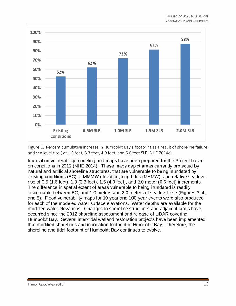
Low-lying former tidelands that were separated from Humboldt Bay more than a century ago with the construction of dikes and railroad beds are at risk of future inundation by extreme tides, storms, El Niño events, and sea level rise due to existing shoreline conditions. In 2013, Trinity Associates produced a Shoreline Inventory and Map for Humboldt Bay, and prepared a Shoreline Sea Level Rise Vulnerability Assessment that identified 26.2 miles of shoreline segments (21.0 miles of dike and 5.1 miles of railroad) highly vulnerable to breaching and/or overtopping (Laird and Powell 2013). Eureka Slough has the greatest length of diked shoreline rate highly vulnerable, 7.13 miles, followed by South Bay with 5.1 miles, Mad River Slough 4.4 miles, and Arcata Bay has the greatest length of railroad shoreline rate highly vulnerable, 4.0 miles. Based on Phase II inundation vulnerability mapping (NHE 2014c), under current conditions, if these highly vulnerable shoreline structures are breached, the tidal inundation footprint of Humboldt Bay (at MMMW) could expand by 52 percent (8,918 acres). Due to topographic constraints around Humboldt Bay, after the protective shoreline ceases to function due to breaching, sea level rise would incrementally increase the tidal footprint an average of 1,512 acres for each 0.5 meter (1.6 foot) rise in tide elevation (Figure 2).
HUMBOLDT BAY SEA LEVEL RISE ADAPTATION PLANNING PROJECT
Trinity Associates 2015 13
Figure 2. Percent cumulative increase in Humboldt Bay’s footprint as a result of shoreline failure and sea level rise ( of 1.6 feet, 3.3 feet, 4.9 feet, and 6.6 feet SLR, NHE 2014c).
Inundation vulnerability modeling and maps have been prepared for the Project based on conditions in 2012 (NHE 2014). These maps depict areas currently protected by natural and artificial shoreline structures, that are vulnerable to being inundated by existing conditions (EC) at MMMW elevation, king tides (MAMW), and relative sea level rise of 0.5 (1.6 feet), 1.0 (3.3 feet), 1.5 (4.9 feet), and 2.0 meter (6.6 feet) increments. The difference in spatial extent of areas vulnerable to being inundated is readily discernable between EC, and 1.0 meters and 2.0 meters of sea level rise (Figures 3, 4, and 5). Flood vulnerability maps for 10-year and 100-year events were also produced for each of the modeled water surface elevations. Water depths are available for the modeled water elevations. Changes to shoreline structures and adjacent lands have occurred since the 2012 shoreline assessment and release of LiDAR covering Humboldt Bay. Several inter-tidal wetland restoration projects have been implemented that modified shorelines and inundation footprint of Humboldt Bay. Therefore, the shoreline and tidal footprint of Humboldt Bay continues to evolve.
52%
62%
72%
81%
88%
0%
10%
20%
30%
40%
50%
60%
70%
80%
90%
100%
ExistingConditions
0.5M SLR 1.0M SLR 1.5M SLR 2.0M SLR

HUMBOLDT BAY SEA LEVEL RISE ADAPTATION PLANNING PROJECT
Trinity Associates 2015 14
Figure 3. Potential tidal inundation areas in Mad River Slough and Arcata Bay under existing conditions (EC) if shoreline structures are breached at MMMW (light blue), 1.0 meters (3.3 feet) (blue), and 2.0 meters (6.6 feet, dark blue, NHE 2014b).
HUMBOLDT BAY SEA LEVEL RISE ADAPTATION PLANNING PROJECT
Trinity Associates 2015 15
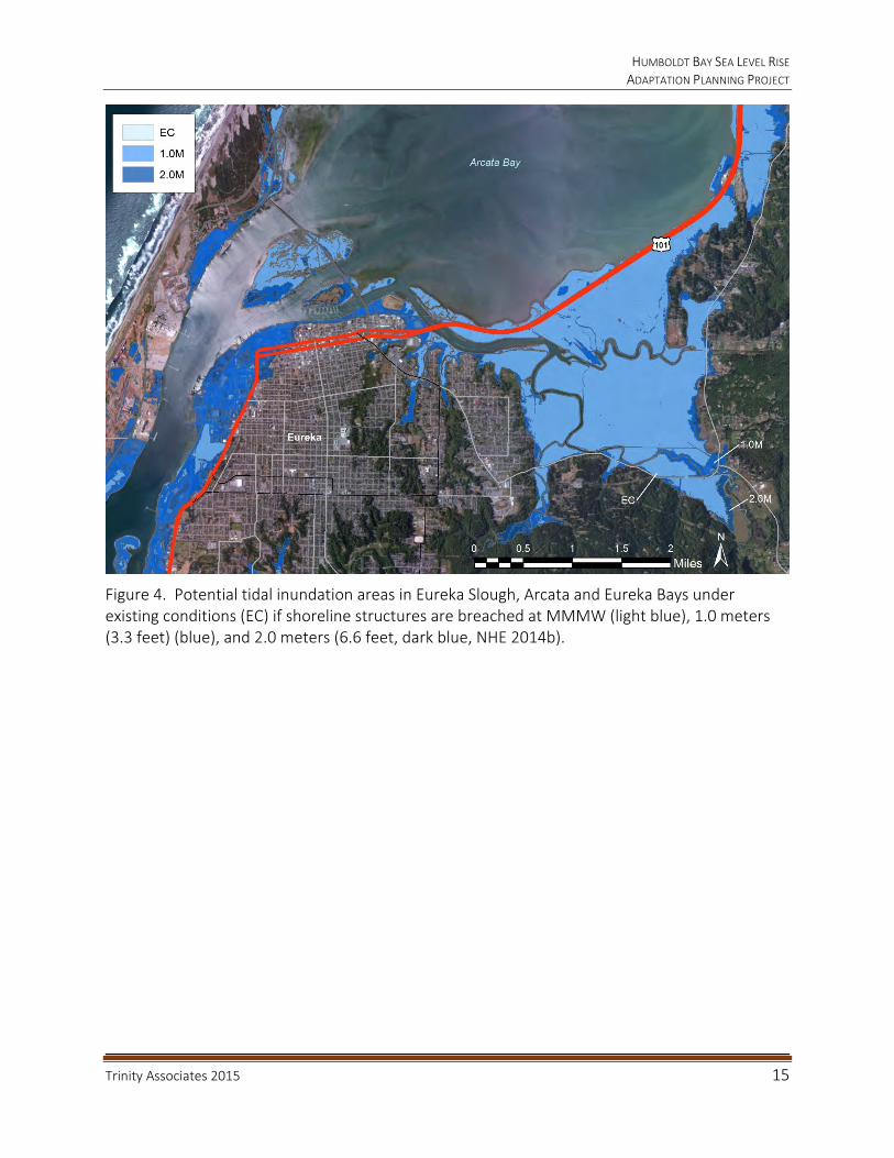
Figure 4. Potential tidal inundation areas in Eureka Slough, Arcata and Eureka Bays under existing conditions (EC) if shoreline structures are breached at MMMW (light blue), 1.0 meters (3.3 feet) (blue), and 2.0 meters (6.6 feet, dark blue, NHE 2014b).

HUMBOLDT BAY SEA LEVEL RISE ADAPTATION PLANNING PROJECT
Trinity Associates 2015 16
Figure 5. Potential tidal inundation areas in Elk River Slough and South Bay under existing conditions (EC) if shoreline structures are breached at MMMW (light blue), 1.0 meters (3.3 feet) (blue), and 2.0 meters (6.6 feet, dark blue, NHE 2014b).

HUMBOLDT BAY SEA LEVEL RISE ADAPTATION PLANNING PROJECT
Trinity Associates 2015 17
3. When Will Sea Level Rise Impact Humboldt Bay?
Currently, tidal elevations in Humboldt Bay are affected by regional sea levels and vertical land motion trends. Since 1977, based on the North Spit tide gage record (http://tidesandcurrents.noaa.gov/stationhome.html?id=9418767) Humboldt Bay is subsiding and its average rate of relative sea level rise of 0.15 inches/year (15 inches per century) is greater than anywhere else in California. Relative sea level rise projections have been prepared for the North Spit tide gage from 2000 to 2100, including low and high greenhouse gas emission scenarios (Table 2; NHE 2014a). In 2013, the California Coastal Commission released a draft of its sea level rise policy guidance that recommends assessing impacts from sea level rise for the following time periods: 2030, 2050, and 2100.
Table 2. Relative sea level rise estimations for three planning horizons, including low and high greenhouse gas emission scenarios (NHE 2014a).
The range of relative sea level rise elevations for 2030 (0.4 to 0.9 feet) is within the current range of tidal elevations experienced annually on Humboldt Bay (1.0 foot) between MMMW 7.74 feet to MAMW 8.79 feet. Sea level rise elevations that exceed what currently occurs on Humboldt Bay are expected by 2050, when MMMW elevations will equal today’s MAMW elevation of 8.79 feet. MAMW in 2050 will be 9.79 feet, or 1.9 feet (23 inches) higher than today’s MMMW elevation. It is difficult to differentiate areas that are vulnerable to RSLR projections for 2030 of 0.6 feet (7 inches) from areas vulnerable to projections for 2050 of 1.1 feet (13 inches). Therefore, we recommend using just a single future planning horizon of 2050. Using a 2050 planning horizon complies with California Executive Order S-13-08, which requires all state agencies that are planning construction projects in areas vulnerable to sea level rise to consider a range of sea level rise scenarios for 2050 and 2100. This later planning horizon would take into account the design life for most development projects, which exceeds the 16-year period between 2014 and 2030; the 36-year timespan to 2050 would be more effective. Relative sea level rise rates are expected to accelerate in the latter half of this century and there is less certainty and a greater range in estimated MMMW elevations for 2100 (2.0 to 5.3 feet). It is worth noting that these projections do not take into account catastrophic contributions from the Greenland and Antarctic ice sheets, which could significantly increase global sea levels (Englander 2012).
YEAR LOW PROJECTED HIGH
Feet Meters Feet Meters Feet Meters
2030 0.4 0.1 0.6 0.2 0.9 0.3
2050 0.7 0.2 1.1 0.3 1.9 0.6
2100 2.0 0.6 3.2 1.0 5.3 1.6

HUMBOLDT BAY SEA LEVEL RISE ADAPTATION PLANNING PROJECT
Trinity Associates 2015 18
4. What Will Sea Level Rise Impact on Humboldt Bay?
Regional assets were considered critical if they provided services necessary for the public’s health and safety or if the loss or impairment of an asset would affect large numbers of people or properties/business in the Humboldt Bay region. Critical regional asset categories in the Humboldt Bay region are: urban areas, coastal resources (agricultural lands, seasonal freshwater wetlands, and wildlife habitats), utilities, and transportation infrastructure. For example, agricultural lands located on diked former tidelands exist because of protective shoreline structures. These structures also protect important coastal wetlands and wildlife habitat, as well as regionally important utilities such as PG&E’s gas transmission lines and electrical transmission towers, municipal water transmission lines, and state Highway 101. Asset criticality, or how important an asset or its services is compared to other assets, was not established by the APWG, nor has priority been assigned to assets.
Three planning periods were utilized to identify critical regional assets that are located in areas vulnerable to inundation if the shoreline is compromised: existing conditions (2015), near-term conditions from 2015 to 2050, and long-term conditions from 2050 to 2100 (Table 3). This report focuses on tidal inundation, which will initiate a process of land use and habitat conversion, therefore only the critical regional assets at risk from tidal inundation are identified in this section, not those assets at risk from a 100-year event at various sea level elevations. To put the 100-year event in perspective, it is approximately 0.8 meters (2.2 feet) higher in elevation (9.24 feet) than our tidal baseline elevation of MMMW (7.74 feet). The 1.0 meter tidal inundation vulnerability footprint projected for 2100 is larger than the current 100-year event flood zone. Due to topographic confinement around Humboldt Bay the assets identified as at risk from 1.0 meter (3.3 foot) of sea level rise by 2100 in most cases are the same assets currently at risk from a 100-year event (2.2 feet).
2014: Current Conditions
Based on current conditions, the following critical regional assets are located in areas that were mapped as vulnerable to tidal inundation by MMMW tides (7.74 feet) and MAMW king tide (8.79 feet) and are most at risk if shoreline structures such as dikes and railroad beds are breached or overtopped.
Urban Areas: Jacobs Ave, Eureka
Coastal Resources: Agricultural Lands
o Mad River Slough, Arcata Bay, Eureka Slough, Eureka Bay, Elk River Slough, and South Bay
Seasonal Freshwater Wetlands/Inter-tidal Wetlands/Wildlife Refuges o Mad River Slough, Arcata Bay, Eureka Slough, Eureka Bay, Elk River
Slough, and South Bay
HUMBOLDT BAY SEA LEVEL RISE ADAPTATION PLANNING PROJECT
Trinity Associates 2015 19
Utilities: Humboldt Bay Municipal Water District underground water transmission lines
o Mad River Slough City of Eureka underground municipal water transmission lines and pump
stations o Arcata Bay, Eureka Slough
Humboldt Community Services District (HCSD) underground municipal water transmission lines and pump stations
o Eureka Bay, Elk River Slough Pacific Gas & Electric underground gas transmission lines and electrical
transmission towers o Arcata Bay, Eureka Slough, Eureka Bay, Elk River Slough, and South Bay
Transportation Systems: Murray Field Airport
o Eureka Slough Portions of Caltrans Highway 101
o South Bay and Lower Arcata Bay Portions of Caltrans Highway 255
o Arcata Bay City of Eureka, City of Arcata, and Humboldt County local streets and roads
o Mad River Slough, Eureka Slough, and Elk River Slough
2015 to 2050: Near‐term Conditions
Based upon current conditions, the following critical regional assets are located in areas that were mapped as vulnerable to tidal inundation by MMMW + 0.5 meter (9.38 feet) water elevation, which is within the range of estimated water elevations for 2050 (0.7 to 1.9 feet), and are at risk if existing shoreline structures such as dikes and railroad beds are breached or overtopped.
Urban Areas: Portions of South G Street, Arcata Portions of Indianola, Eureka Portions west of Broadway, Eureka Portions north of 4th Street, Eureka Portions of Fairhaven King Salmon Fields Landing
Utilities: City Eureka, City of Arcata, and County stormwater systems
o Arcata Bay, Eureka Bay, Eureka Slough, Elk River Slough and South Bay City of Eureka and HCSD underground wastewater transmission lines and pump
stations o Eureka Bay, Eureka Slough, Elk River Slough, and South Bay
City of Eureka underground municipal water lines
HUMBOLDT BAY SEA LEVEL RISE ADAPTATION PLANNING PROJECT
Trinity Associates 2015 20
o Eureka Bay, Eureka Slough, Elk River Slough, and South Bay Portions of City of Arcata wastewater treatment facility
o Arcata Bay Portions of Chevron Fuel Depot
o Eureka Bay
Transportation Systems: Highway 101
o South Bay and Lower Arcata Bay Highway 255
o North Arcata Bay City of Eureka, City of Arcata, and County local streets and roads
o Mad River Slough, Arcata Bay, Eureka Slough, Eureka Bay, Elk River Slough and South Bay
2050 to 2100: Long‐term Conditions
Based on current conditions, the following critical regional assets are located in areas that are vulnerable to tidal inundation by the projected MMMW + 1.0 meter (11.02 feet) water elevation, and are at risk if existing shoreline structures such as dikes and railroad beds are breached or overtopped.
Urban Areas: South F, G, and H Streets, Arcata, Indianola, Eureka Fairhaven West of Broadway, Eureka North of 4th Street Eureka,
Utilities: Portions of City of Eureka regional wastewater treatment facility
o Eureka Bay City of Arcata wastewater treatment facility
o Arcata Bay Chevron Fuel Depot
o Eureka Bay Portions of PG&E Power Plant
o South Bay
Transportation System: Highway 101
o Upper Arcata Bay and Elk River Slough Highway 255
o West Arcata Bay City of Eureka, City of Arcata, and County local streets and roads
o Mad River Slough, Arcata Bay, Eureka Slough, Eureka Bay, Elk River Slough and South Bay
HUMBOLDT BAY SEA LEVEL RISE ADAPTATION PLANNING PROJECT
Trinity Associates 2015 21
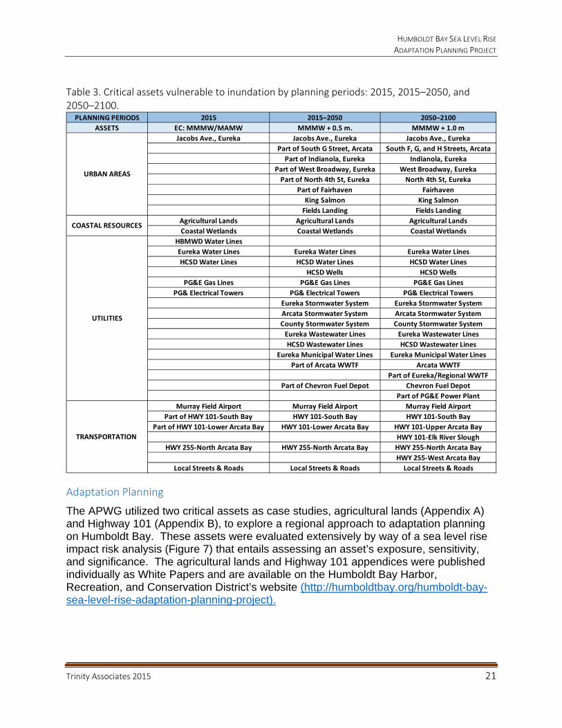
Table 3. Critical assets vulnerable to inundation by planning periods: 2015, 2015–2050, and 2050–2100.
Adaptation Planning
The APWG utilized two critical assets as case studies, agricultural lands (Appendix A) and Highway 101 (Appendix B), to explore a regional approach to adaptation planning on Humboldt Bay. These assets were evaluated extensively by way of a sea level rise impact risk analysis (Figure 7) that entails assessing an asset’s exposure, sensitivity, and significance. The agricultural lands and Highway 101 appendices were published individually as White Papers and are available on the Humboldt Bay Harbor, Recreation, and Conservation District’s website (http://humboldtbay.org/humboldt-bay-sea-level-rise-adaptation-planning-project).
PLANNING PERIODS 2015 2015‒2050 2050‒2100
ASSETS EC: MMMW/MAMW MMMW + 0.5 m. MMMW + 1.0 m
Jacobs Ave., Eureka Jacobs Ave., Eureka Jacobs Ave., Eureka
Part of South G Street, Arcata South F, G, and H Streets, Arcata
Part of Indianola, Eureka Indianola, Eureka
Part of West Broadway, Eureka West Broadway, Eureka
Part of North 4th St, Eureka North 4th St, Eureka
Part of Fairhaven Fairhaven
King Salmon King Salmon
Fields Landing Fields Landing
Agricultural Lands Agricultural Lands Agricultural Lands
Coastal Wetlands Coastal Wetlands Coastal Wetlands
HBMWD Water Lines
Eureka Water Lines Eureka Water Lines Eureka Water Lines
HCSD Water Lines HCSD Water Lines HCSD Water Lines
HCSD Wells HCSD Wells
PG&E Gas Lines PG&E Gas Lines PG&E Gas Lines
PG& Electrical Towers PG& Electrical Towers PG& Electrical Towers
Eureka Stormwater System Eureka Stormwater System
Arcata Stormwater System Arcata Stormwater System
County Stormwater System County Stormwater System
Eureka Wastewater Lines Eureka Wastewater Lines
HCSD Wastewater Lines HCSD Wastewater Lines
Eureka Municipal Water Lines Eureka Municipal Water Lines
Part of Arcata WWTF Arcata WWTF
Part of Eureka/Regional WWTF
Part of Chevron Fuel Depot Chevron Fuel Depot
Part of PG&E Power Plant
Murray Field Airport Murray Field Airport Murray Field Airport
Part of HWY 101‐South Bay HWY 101‐South Bay HWY 101‐South Bay
Part of HWY 101‐Lower Arcata Bay HWY 101‐Lower Arcata Bay HWY 101‐Upper Arcata Bay
HWY 101‐Elk River Slough
HWY 255‐North Arcata Bay HWY 255‐North Arcata Bay HWY 255‐North Arcata Bay
HWY 255‐West Arcata Bay
Local Streets & Roads Local Streets & Roads Local Streets & Roads
TRANSPORTATION
COASTAL RESOURCES
UTILITIES
URBAN AREAS

HUMBOLDT BAY SEA LEVEL RISE ADAPTATION PLANNING PROJECT
Trinity Associates 2015 22
Figure 7. Risk analysis entails assessing an asset’s exposure, sensitivity, and significance.
Exposure
Analyzing an asset’s exposure to sea level rise involves determining the mode of impact: tidal inundation, flooding, shoreline erosion, or salt water intrusion. It is also necessary to evaluate the timing of the impact, and the magnitude of asset damage under each mode of impact.
Sensitivity
Sensitivity is the degree to which an asset is affected. Resiliency is the ability of an asset to absorb some amount of change, including extreme events, and recover from or adjust easily to the change or other stress. Adaptive capacity is not an attribute of the asset but a measure of the ability of the owner or responsible parties to address impacts to the asset based upon: access, engineering standards, environmental statutes, and economic ability to fund implementation of adaptation measures.
Significance
A very important criterion in assessing asset risk is determining its significance, or the value of its services to the well-being of the community. Assessing consequence involves determining the level of damage, the length of time service would be disrupted, the cost to repair or replace the asset, and the secondary economic and social impacts of the asset being disabled. Assessing age, condition, and materials of an asset is helpful in determining the consequence of asset impairment or failure. Prioritizing at-risk assets is an important step for development and funding of adaptation measures; however, it will likely be a difficult and controversial exercise that should involve asset owners, beneficiaries, land use and regulatory agencies, and the public. As a result, it has been deferred to a future time.
EXPOSURE
How
When
Magnitude
SENSITIVITY
Resiliency
AdaptiveCapacity
SIGNIFICANCE
Consequence
Prioritize
HUMBOLDT BAY SEA LEVEL RISE ADAPTATION PLANNING PROJECT
Trinity Associates 2015 23
Adaptation Strategies
In general, adaptation strategies fall under several categorical approaches to address sea level rise impacts to assets at risk: (1) no action or “business as usual,” (2) protect/defend, (3) accommodate/adapt, and (4) relocate/retreat. Education is an adaptation strategy that is common to all strategies and should be the first to be employed. At a minimum, sea level rise education needs to convey which areas are currently vulnerable to tidal inundation under existing tidal conditions, and should ideally include areas predicted to be vulnerable to extreme flood events and future sea level rise. The properties, infrastructures, and services at risk in these areas are also important to identify and share.
Regardless of what approach is selected to adapt to sea level rise impacts, funding and regulatory flexibility are two critical issues that need to be addressed. Normal capital funding mechanisms are currently unable to accommodate the huge backlog of necessary infrastructure improvements; they cannot be expected to also fund new adaptation projects. Developing and implementing adaption strategies for assets at risk will require decades of planning, design, and implementation, as well as significant financial investments. New state and federal funding sources will be needed to address sea level rise impacts. Implementing adaptation measures will require permits. Regulatory constraints to potential adaptation strategies and options could be reduced with the integration of local, state and federal statutes into flexible programmatic authorizations. Jurisdictional integration/collaboration among Humboldt Bay’s Local Coastal Program (LCP) authorities (Humboldt County, City of Eureka, and City of Arcata) and management authorities (Coastal Commission and HBHRCD) could also facilitate the development and implementation of adaptation strategies and options.
5. Who Will Address Sea Level Rise Impacts on Humboldt Bay?
Adaptation planning needs to identify which adaptation strategies and options are feasible for an asset at risk, when that adaptation option should be employed, and ultimately who will pay for implementation of the options. This begs the question who is going to address sea level rise impacts on Humboldt Bay? Adaptive capacity has been described as a measure of the ability of an entity responsible for an asset to feasibly address impacts from sea level rise. A significant contribution to adaptive capacity is the ability to finance responses to sea level rise impacts. But an asset can provide services to a host of entities who do not own or have responsibility for that asset from which they are benefitting. While LCP authorities regulate land use in their jurisdictions, they do not generally own or control all of the assets that their communities rely on for critical services. For example, the City of Eureka owns its municipal water, wastewater, and stormwater facilities but not the energy utilities that provide the City with natural gas, electricity, or petroleum products. The capacity to respond to sea level rise impacts to these utilities may need to be shared with asset owners, the City, and customers of these utilities.
Determining who owns, is responsible for, is dependent upon or uses the services provided by a critical asset at risk will likely identify who should be involved in selecting appropriate adaptation strategies, developing feasible adaptation options, and securing

HUMBOLDT BAY SEA LEVEL RISE ADAPTATION PLANNING PROJECT
Trinity Associates 2015 24
funds for implementing these options. For example, in one of the Project’s two case studies which evaluates agricultural lands on diked former tidelands, forming an adaptation planning group solely based on property ownership of the protective shoreline would be insufficient to identify all of the stakeholders associated with the diked shoreline structures. There are many situations on Humboldt Bay where property, structures, or resources are being protected from sea level rise by shoreline structures located on property not owned or controlled by the beneficiary of these protective structures. The diked shoreline on Humboldt Bay and its sloughs traverse and protect both private and publicly owned agricultural and wildlife lands. These diked shorelines also protect critical utilities (municipal water, wastewater, gas, and electrical) and transportation (Caltrans Highway 101, 255, and local streets and roads) assets. Selecting sea level rise impact adaptation strategies and adaptation options will need to involve regulatory land use authorities who are also stakeholders, such as Humboldt County, City of Eureka, City of Arcata, and California Coastal Commission. Adaptation planning for an at-risk asset should be undertaken by a collaborative stakeholder group consisting of direct asset/property owners, asset/property owners who are affected or derive benefits from the asset, LCP and regulatory authorities, and if possible, funding agencies. Successful implementation of adaptation options will likely require partnerships among affected stakeholders.
To date, sea level rise adaptation planning efforts in California have mostly been initiated by LCP authorities, regional collaborations of governments, and state or federal resource agencies. Funding for local efforts has primarily been from California’s coastal program agencies (Coastal Conservancy, Coastal Commission, and Ocean Protection Council), while the federal government has funded adaptation planning efforts of natural resource management and transportation agencies. NOAA Coastal Services Center has been actively funding and providing training for sea level rise adaptation for local and regional groups with a broad focus. The Coastal Commission has produced a sea level rise guidance document to help local governments, permit applicants, and other interested parties begin to address the challenges of sea level rise (CCC 2013). Projects proposed to implement sea level rise adaptation options will require authorization from either the LCP authority or the California Coastal Commission. California is actively funding LCP updates to address sea level rise impacts to local communities. The three LCP authorities on Humboldt Bay (Humboldt County, City of Eureka, and City of Arcata) have all received funding to update their Land Use Plans for sea level rise.
At this time, assessing sea level rise impacts for an individual proposed project/development is not required, pursuant to the California Environmental Quality Act (CEQA). The courts have held that the purpose of CEQA is to assess, disclose, and mitigate project impacts to the environment, not environmental impacts such as sea level rise on a land use or development. However, California Executive Order S-13-08 requires all state agencies that are planning construction projects in areas vulnerable to sea level rise to consider a range of sea level rise scenarios for 2050 and 2100 in order to assess project vulnerability, to reduce expected risks, and to increase resiliency to sea level rise. The Coastal Commission sea level rise guidance document does address the need of Coastal Development Permit applicants to assess the impact of
HUMBOLDT BAY SEA LEVEL RISE ADAPTATION PLANNING PROJECT
Trinity Associates 2015 25
sea level rise on their proposed development. In addition, Humboldt Bay Area Plan Policy 3.17.B.3 does require that new subdivisions or development projects which could result in one or more additional dwelling units within a potential tsunami run-up area shall not have habitable living space below the predicted tsunami run-up elevation calculated at maximum tide plus a minimum of three (3) feet to account for future sea level rise plus one foot of freeboard space.
There are six hydrologic units on Humboldt Bay: Arcata, Eureka and South Bays, and Mad River, Eureka and Elk River Sloughs. These six hydrologic units can be stratified into a total 27 hydrologically separate sub-units or flood cells, the Eureka Slough hydrologic unit for example has eight sub-units (Figure 8). Management must focus on the shoreline of each hydrologic sub-unit of Humboldt Bay that contains an asset that is at risk since flood waters do not respect parcel or jurisdictional boundaries. Historically, Reclamation Districts were authorized by the State or County to tax landowners who benefitted from the District’s construction and maintenance of dikes and water control structures. On Humboldt Bay, there is only one existing Reclamation District (designated Reclamation District 768), and it covers the northern portion of Arcata Bay west of Arcata and up Mad River Slough to the junction with Liscom Slough. Following a major breach on Mad River Slough in 2003 and Hurricane Katrina in 2005, the Reclamation District was the recipient of emergency funds from the Federal Emergency Management Agency to fortify its dikes. The Humboldt County Board of Supervisors is also the governing board of the Humboldt County Flood Control District. The District recently received funds for the Jacobs Avenue Levee Evaluation Project for engineering studies and hopefully will secure funds to improve the levee along Eureka Slough. The enabling legislation for the Humboldt Bay Harbor, Conservation and Recreation District granted the District authority to regulate development of the tidal shoreline on Humboldt Bay. The District, in collaboration with the County and Cities, could provide local leadership for collaborative stakeholder group sea level rise adaptation planning efforts on Humboldt Bay.

HUMBOLDT BAY SEA LEVEL RISE ADAPTATION PLANNING PROJECT
Trinity Associates 2015 26
Figure 8. Blue shaded areas depict eight discrete hydrological sub‐units within the larger Eureka Slough hydrologic complex that are vulnerable to inundation, if the diked shoreline were to be breached or overtopped (NHE 2014b).
Specific Humboldt Bay critical assets that require adaptation strategies and options include: Urban Areas, Coastal Resources, Utilities, and Transportation systems.
Urban Areas
Urban Areas that are at risk from shoreline failure and sea level rise, through 2100, are located in the unincorporated areas of Humboldt County (see Risk Analysis section for complete list) and the Cities of Eureka and Arcata. These urban areas are located in low-lying areas adjacent to Humboldt Bay. There may also be contaminated sites in these low-lying areas; if sea level rise were allowed to inundate these areas before they are remediated, there are concerns that pollutants could impact water quality in
HUMBOLDT BAY SEA LEVEL RISE ADAPTATION PLANNING PROJECT
Trinity Associates 2015 27
Humboldt Bay. When updating their LCPs, the LCP authorities should take into account sea level rise impacts on these urban areas and existing development, as well as planning for future land uses and developments. For example, the capacity of wastewater treatment facilities serving these urban areas can be compromised during periods of heavy rainfall and stormwater discharge that infiltrate underground sewer lines. The ability of a wastewater treatment facility to maintain existing capacity or accommodate future growth may be impaired by tidal inundation and infiltration of underground sewer lines, which may reduce the facility’s capacity. This type of impact serves to illustrate the vulnerability of urban areas; tidal inundation of surface land uses may be preceded by tidal inundation impacts to critical underground utilities. Critical underground utilities are both privately owned (natural gas, electricity, and communications) and publicly owned (sewer, water, and stormwater) and provide necessary services to support urban communities composed of privately and publically owned properties. The collaborative stakeholder group and process to address sea level rise impacts in urban areas would likely be led by the LCP authority and include potentially affected property owners, public, and local and state agencies.
Coastal Resources
Sea level rise will impact coastal aquatic and terrestrial resources on Humboldt Bay. Aquatic resources include eel grass, salt marsh, estuaries, brackish water wetlands, and low gradient fish habitats. In order to adapt to increasing water depths or expanding tidal influences, these aquatic habitats will need to migrate if they are to survive.
Coastal terrestrial resources on Humboldt Bay that are most at risk from tidal inundation or flooding are the diked former tidelands that support agricultural uses, seasonal freshwater wetlands, and wildlife habitats and populations. There are 41 miles of earthen dikes on Humboldt Bay, protecting approximately 8,000 acres of low-lying former tidelands. Based on current shoreline conditions, extreme high tides and storm surges can overtop low elevation dikes, and wind waves can erode unfortified dikes, causing them to breach. The resulting flooding of former tidelands, now agricultural lands, with salt water will threaten existing terrestrial uses and resources. Currently, 21 miles of diked shoreline is rated highly vulnerable due to an eroding shoreline and/or dike elevation that is within two feet of the base MMMW elevation of 7.74 feet (Laird and Powell 2013). On Humboldt Bay, a combination of king tides and storm surges or El Niño events can result in 2 feet of SLR for a short duration, as occurred on New Year’s Eve 2005, resulting in the highest water elevation ever recorded at the North Spit tide gage (9.55 feet). The 21 miles of highly vulnerable diked shoreline put thousands of acres of low-lying agricultural lands and critical assets located on these lands or protected by these shoreline structures at immediate risk from shoreline breaching and tidal inundation.
Significant portions of these diked former tideland areas are in the unincorporated area of the County, while much of the Fay Slough bottom land is in City of Eureka’s jurisdiction, and similarly much of the Bayside bottom land is in the City of Arcata. Almost all of the diked former tidelands are within the retained jurisdiction area of the

HUMBOLDT BAY SEA LEVEL RISE ADAPTATION PLANNING PROJECT
Trinity Associates 2015 28
Coastal Commission. These agricultural lands have a mix of both private and public ownership, with much of the public lands being managed for wildlife and open space/recreation (City of Eureka and City of Arcata, California Department of Fish and Wildlife, Humboldt Bay National Wildlife Refuge, Bureau of Land Management, and several land trusts). The collaborative stakeholder group and process to address sea level rise impacts in agricultural areas would likely include potentially affected property owners, the public, Humboldt County Resource Conservation District, LCP authorities, Coastal Commission, and National Resources Conservation Service.
Utilities
Utilities include both public (water, wastewater, and stormwater) and private (natural gas, electricity, and communications) systems. Utility systems are composed of linear underground assets and buildings/pump stations/towers. These utilities traverse multiple land use jurisdictions and properties often in right-of-ways located on low-lying lands behind protective shoreline structures, not owned or maintained by the utility. The collaborative stakeholder group and process to address sea level rise impacts to utilities could be led by the LCP authorities or by PG&E, but the process would also need to include potentially affected property owners, public, and local and state agencies.
Transportation Systems
There are both state and local transportation facilities that are vulnerable to tidal inundation on Humboldt Bay. Highway 101 is an important inter-state transportation corridor that extends south from Humboldt Bay and north to Oregon and Washington. Highway 255 is a state asset that locally links the communities of Fairhaven, Samoa, and Manila with the Cities of Eureka and Arcata. Highway 255 is also the only vehicular access route to the Wiyot Tribe’s Tuluwat ceremonial site on Indian Island. There are numerous County roads and City streets that are vulnerable to tidal inundation under existing conditions and will become more vulnerable should shoreline protective structures fail and as the sea level continues to rise. The collaborative stakeholder group and process to address sea level rise impacts to transportation facilities on Humboldt Bay would likely be led by the Humboldt County Association of Governments, which serves as the Regional Transportation Planning Agency. The process would need to include Caltrans and potentially affected property owners, public, and local and state agencies.
CONCLUSIONS & RECOMMENDATIONS
1. Identify critical asset stakeholders:
Who owns, is responsible for, is dependent upon or uses the services provided by a critical asset at risk, people who derive benefits from this asset, and LCP and regulatory authorities; and
Who should be involved in selecting appropriate adaptation strategies, developing feasible adaptation options, and securing funds for implementing these options.

HUMBOLDT BAY SEA LEVEL RISE ADAPTATION PLANNING PROJECT
Trinity Associates 2015 29
2. Stakeholders of critical assets at risk need to form collaborative stakeholder adaptation planning groups, and if possible, include funding agencies. Building collaborative partnerships will be a crucial component to:
Select feasible adaptation strategies and develop adaptation options,
Determine the timing for initiation/implementation of adaptation options,
Choose a lead agency/entity to permit and implement adaptation options, and
Locate and secure the necessary funding.
3. Education of collaborative stakeholder groups is a component that is common to all adaptation strategies and should be the first to be employed. At a minimum, sea level rise education needs to convey which areas are currently vulnerable to tidal inundation under existing tidal conditions, and should ideally include areas predicted to be vulnerable to extreme flood events and future sea level rise. The properties, infrastructures, and services at risk in these areas are also important to identify and share. It will be important for adaptation planning stakeholder groups to not work in isolation, and to learn about and evaluate potential sea level rise adaptation strategies being pursued for other critical assets at risk on Humboldt Bay.
4. Regardless of which approach is selected to adapt to sea level rise impacts, funding and regulatory flexibility are two critical issues that also need to be addressed. Normal capital funding mechanisms are currently unable to accommodate the huge backlog of necessary infrastructure improvements; they cannot be expected to also fund new adaptation projects. Developing and implementing adaption strategies for assets at risk will require decades of planning, design, and implementation as well as significant financial investments. New state and federal funding sources will be needed to address sea level rise impacts. Implementing adaptation measures will require permits. Regulatory constraints to potential adaptation strategies and options could be reduced with the integration of local, state and federal statutes into flexible programmatic authorizations. Jurisdictional integration/collaboration among Humboldt Bay’s LCP authorities (Humboldt County, City of Eureka and City of Arcata) and management authorities (Coastal Commission and HBHRCD) could also facilitate the development and implementation of adaptation strategies and options.
5. Management must focus on the shoreline of each hydrologic sub-unit of Humboldt Bay that contains an asset that is at risk, since flood waters do not respect parcel or jurisdictional boundaries.
6. The enabling legislation for the Humboldt Bay Harbor, Conservation and Recreation District granted the District authority to regulate development of the tidal shoreline on Humboldt Bay. The District, in collaboration with the County and Cities, could provide local leadership for collaborative stakeholder group sea level rise adaptation planning efforts on Humboldt Bay.

HUMBOLDT BAY SEA LEVEL RISE ADAPTATION PLANNING PROJECT
Trinity Associates 2015 30
7. Urban Areas that are at risk from shoreline failure and sea level rise through 2100 are located in the unincorporated areas of Humboldt County and the Cities of Eureka and Arcata. These urban areas are located in low-lying areas adjacent to Humboldt Bay. There may also be contaminated sites in these low-lying areas; if sea level rise were allowed to inundate these areas before they are remediated, there are concerns that pollutants could impact water quality in Humboldt Bay. When updating their LCPs, the LCP authorities should take into account sea level rise impacts on these urban areas and existing development, as well as planning for future land uses and developments. The collaborative stakeholder group and process to address sea level rise impacts in urban areas would likely be led by the LCP authority and include potentially affected property owners, public, and local and state agencies.
8. Significant portions of the diked former tideland areas are in the unincorporated area of the County, while much of the Fay Slough bottom land is in City of Eureka’s jurisdiction, and similarly much of the Bayside bottom land is in the City of Arcata. Almost all of the diked former tidelands are within the retained jurisdiction area of the Coastal Commission. These agricultural lands have a mix of both private and public ownership, with much of the public lands being managed for wildlife and open space/recreation (City of Eureka and City of Arcata, California Department of Fish and Wildlife, Humboldt Bay National Wildlife Refuge, Bureau of Land Management, and several land trusts). The collaborative stakeholder group and process to address sea level rise impacts in agricultural areas would likely include potentially affected property owners, the public, Humboldt County Resource Conservation District, LCP authorities, Coastal Commission, and National Resources Conservation District
9. Utilities include both public (water, wastewater, and stormwater) and private (natural gas, electricity, and communications) systems. Utility systems are composed of linear underground assets and buildings/pump stations/towers. These utilities traverse multiple land use jurisdictions and properties often in right-of-ways located on low-lying lands behind protective shoreline structures, not owned or maintained by the utility. The collaborative stakeholder group and process to address sea level rise impacts to utilities could be led by the LCP authorities or by PG&E, but the process would also need to include potentially affected property owners, public, and local and state agencies
10. There are both state and local transportation facilities that are vulnerable to tidal inundation on Humboldt Bay. Highway 101 is an important inter-state transportation corridor that extends south from Humboldt Bay and north to Oregon and Washington. Highway 255 is a state asset that locally links the communities of Fairhaven, Samoa, and Manila with the Cities of Eureka and Arcata. Highway 255 is also the only vehicular access route to the Wiyot Tribe’s Tuluwat ceremonial site on Indian Island. There are numerous County roads and City streets that are vulnerable to tidal inundation under existing conditions and will become more vulnerable should shoreline protective structures fail and as the sea level continue to rise. The collaborative stakeholder group and process

HUMBOLDT BAY SEA LEVEL RISE ADAPTATION PLANNING PROJECT
Trinity Associates 2015 31
to address sea level rise impacts to transportation facilities on Humboldt Bay would likely be led by the Regional Transportation Authority-Humboldt County Association of Governments. The process would need to include Caltrans, property owners with protective shoreline structures like dikes, railroad grades and trails, and potentially affected property owners, public, and local and state agencies, who are also benefitting from these protective shoreline structures.
REFERENCES
California Coastal Commission. 2013. Draft Sea-Level Rise Policy Guidance.
California Natural Resources Agency. 2012. California Adaptation Planning Guide.
Englander, John. 2012. High Tide On Main Street: Rising Sea Level and Coming Coastal Crisis.
Laird, Aldaron, Brian Powell. 2013. Humboldt Bay shoreline inventory, mapping, and sea level rise vulnerability assessment, with an Addendum: Shoreline Vulnerability Ratings. Prepared for the California State Coastal Conservancy.
National Oceanic and Atmospheric Administration. 2001. Tidal Datums and Their Applications. NOAA Special Publication NOS CO-OPS 1. U.S. Department of Commerce, National Oceanic and Atmospheric Administration, National Ocean Service, Center for Operational Oceanographic Products and Services, Silver Spring, MD.
Northern Hydrology and Engineering. 2014a. Estimates of local or relative sea level rise for Humboldt Bay region. Prepared for the California State Coastal Conservancy.
Northern Hydrology and Engineering. 2014b. Data release for the Humboldt Bay sea level rise vulnerability assessment: Humboldt Bay sea level rise inundation mapping. Prepared for the California State Coastal Conservancy.
Northern Hydrology and Engineering. 2014c. Humboldt Bay Sea Level Rise Hydrodynamic Modeling and Inundation Vulnerability Mapping. Prepared for the California State Coastal Conservancy.
Russell, Nicole, Gary Griggs. 2012. Adapting to sea level rise: A guide for California’s coastal communities. University of California, Santa Cruz.
HUMBOLDT BAY SEA LEVEL RISE ADAPTATION PLANNING PROJECT
Trinity Associates 2015 A‐1
APPENDIX A: Can Agricultural Lands and Uses on Humboldt Bay Adapt to Sea Level Rise?
HUMBOLDT BAY SEA LEVEL RISE ADAPTATION PLANNING PROJECT
Trinity Associates 2015 A‐2

Can Agricultural Lands and Uses on Humboldt Bay Adapt to Sea Level Rise?
Prepared by:
Aldaron Laird Trinity Associates
980 7th Street, Suite K Arcata, CA 95521
February 2015

HUMBOLDT BAY SEA LEVEL RISE ADAPTATION PLANNING PROJECT
Trinity Associates 2015 A‐4
Acknowledgements
Funding by: California Coastal Conservancy
Sponsored by: Coastal Ecosystems Institute of Northern California
Adaptation Planning Working Group Co-Lead Agencies:
Humboldt Bay Harbor Conservation, and Recreation District Humboldt County Public Works Department (Environmental Services Division)
Sea Level Rise Adaption Planning Consultant: Trinity Associates
Humboldt Bay Sea Level Rise Hydrodynamic Modeling and Inundation Vulnerability Mapping: Northern Hydrology and Engineering
Note: This report was prepared by Trinity Associates and does not necessarily reflect the views of the agencies and organizations that participated in the Humboldt Bay Sea Level Rise Adaptation Planning Group.

HUMBOLDT BAY SEA LEVEL RISE ADAPTATION PLANNING PROJECT
Trinity Associates 2015 A‐5
TABLE OF CONTENTS
BACKGROUND .............................................................................................................. 6
1. Relative Sea Level Rise Projections and Impacts ............................................ 10
2. Vulnerability of Agricultural Lands .................................................................... 13
ADAPTATION STRATEGIES ........................................................................................ 17
1. Education ......................................................................................................... 17
2. No Action.......................................................................................................... 17
3. Protect/Defend ................................................................................................. 18
4. Accommodate/Adapt ........................................................................................ 18
5. Relocate/Retreat .............................................................................................. 19
6. Regulation ........................................................................................................ 19
ADAPTATION MEASURES .......................................................................................... 21
1. Regulatory Constraints to Adaptation Measures .............................................. 23
2. Justifying Adaptation Measures to Regulatory Constraints .............................. 24
CONCLUSIONS ............................................................................................................ 25
REFERENCES .............................................................................................................. 26
HUMBOLDT BAY SEA LEVEL RISE ADAPTATION PLANNING PROJECT
Trinity Associates 2015 A‐6
“In order to adapt to future change in sea level rise, coastal [agricultural landowners and] wildlife area managers need to understand vulnerability and risk, because adaptation to sea level rise is a risk management strategy against an uncertain future.” (Sullivan 2013)
This paper analyzes the climate change impact from sea level rise to agricultural land use around Humboldt Bay, California. This paper covers: (1) anticipated effects from sea level rise; (2) where sea level rise will likely occur; (3) when sea level rise is expected to happen; (4) what would be placed at risk; (5) how sensitive and important are prioritized assets at risk; and (6) development of strategies and recommendations for adaptation to anticipated (modeled) sea level rise impacts.
BACKGROUND
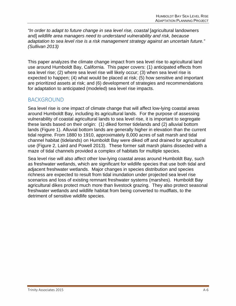
Sea level rise is one impact of climate change that will affect low-lying coastal areas around Humboldt Bay, including its agricultural lands. For the purpose of assessing vulnerability of coastal agricultural lands to sea level rise, it is important to segregate these lands based on their origin: (1) diked former tidelands and (2) alluvial bottom lands (Figure 1). Alluvial bottom lands are generally higher in elevation than the current tidal regime. From 1880 to 1910, approximately 8,000 acres of salt marsh and tidal channel habitat (tidelands) on Humboldt Bay were diked off and drained for agricultural use (Figure 2, Laird and Powell 2013). These former salt marsh plains dissected with a maze of tidal channels provided a complex of habitats for multiple species.
Sea level rise will also affect other low-lying coastal areas around Humboldt Bay, such as freshwater wetlands, which are significant for wildlife species that use both tidal and adjacent freshwater wetlands. Major changes in species distribution and species richness are expected to result from tidal inundation under projected sea level rise scenarios and loss of existing remnant freshwater systems (marshes). Humboldt Bay agricultural dikes protect much more than livestock grazing. They also protect seasonal freshwater wetlands and wildlife habitat from being converted to mudflats, to the detriment of sensitive wildlife species.
HUMBOLDT BAY SEA LEVEL RISE ADAPTATION PLANNING PROJECT
Trinity Associates 2015 A‐7
Figure 1. There are two types of agricultural lands on Humboldt Bay: (1) former tidelands (yellow shading) and (2) alluvial bottom lands (outside of blue tidal boundary of 1870).

HUMBOLDT BAY SEA LEVEL RISE ADAPTATION PLANNING PROJECT
Trinity Associates 2015 A‐8
Figure 2. Historical inter‐tidal wetlands on Eureka Slough, 1870 U.S. Coast Survey.
In general, former tidelands have compacted by as much as three feet over time as organic material in salt marsh soils oxidized, and because sediment accretion from tides has been blocked by dikes and tide gates. In addition, vertical land movement associated with local tectonic activity is causing land in the Humboldt Bay region to subside (Cascadia Geosciences 2013). Combining subsidence on Humboldt Bay with sea level rise over the last 100 years, tidal elevations have increased approximately 1.5 feet – the most of any area on the West Coast (Russell and Griggs 2012). Humboldt Bay’s agricultural lands are primarily protected from salt water inundation during daily high tides by earthen dikes. If these dikes were breached, tidal inundation would cover a substantial area around Humboldt Bay (Figure 3). With time, vulnerability of these agricultural lands is likely to increase; for example with just another 1.5 feet (0.5 meter) of sea level rise, it is projected that today’s 100 year tidal event will become tomorrow’s new annual king tide (Figure 4, NHE 2013).

HUMBOLDT BAY SEA LEVEL RISE ADAPTATION PLANNING PROJECT
Trinity Associates 2015 A‐9
Figure 3. Potential tidal inundation area (blue) by current mean monthly maximum water (MMMW) elevation on Eureka Slough, if existing diked shoreline were not in place (NHE 2014c).

HUMBOLDT BAY SEA LEVEL RISE ADAPTATION PLANNING PROJECT
Trinity Associates 2015 A‐10
Figure 4. With just 0.5 meters (1.6 feet) of sea level rise, the 100‐year event today will become the annual king tide event (NHE 2013).
1. Relative Sea Level Rise Projections and Impacts
California’s Ocean Protection Council and Coastal Commission sea level rise guidance documents recommend incorporating sea level rise projections for 2030, 2050, and 2100 into planning and decision making for projects in California (CO-CAT 2013, CCC 2013).
Based on Humboldt Bay’s North Spit tide gage, relative sea level rise (i.e., the combination of regional sea level rise rates and local vertical land motion rates) is estimated to be approximately 0.6 feet (7 inches) by 2030, 1.1 feet (13 inches) by 2050, and 3.2 feet (39 inches) by 2100 (Figure 5, NHE 2014b). On Humboldt Bay, sea level rise may affect agricultural land uses by shoreline erosion, tidal inundation, flooding, rising groundwater, and salt water intrusion. As sea level rise affects low-lying agricultural land on Humboldt Bay, it also has the potential to impact valuable freshwater waterfowl and shorebird habitats on these same lands that support most of North America’s Aleutian goose population from January through April.

HUMBOLDT BAY SEA LEVEL RISE ADAPTATION PLANNING PROJECT
Trinity Associates 2015 A‐11
Figure 5. Regional and relative sea level rise projections for Humboldt Bay (NHE 2013).
Although sea level rise is expected to eventually result in overtopping dikes, it will likely be annual extreme high tides, known as king tides that breach these dikes in multiple locations. The diked shoreline is expected to provide protection for up to 2 feet above mean monthly maximum water (MMMW) ((7.74 feet NAVD88); thus there is a diked shoreline threshold of 2 feet (that could be achieved with 1 foot relative sea level rise plus 1 foot king tide) given the range RSLR estimates this shoreline threshold could be reached by 2050. Average king tides on Humboldt Bay reach 8.78 feet at the North Spit tide gage, so essentially, we experience 1.04 feet of sea level rise each year for several days during the winter months. On Humboldt Bay, with 1 foot of sea level rise and current shoreline conditions, 11 miles of the dikes could be overtopped during king tides. With 2 feet of sea level rise, king tides could overtop 23 miles of the dikes, and with 3 feet of sea level rise, king tides could overtop 38 miles, or 93 percent of the dikes (Figures 6 and 7, Laird and Powell 2013). If the elevation of these dikes is not raised, a significant threshold will be reached when relative sea level rise is greater than 2.0 feet (9.74 feet), which could be reached by 2050 under the high greenhouse gas emissions scenario projection, or between 2050 and 2075 as the projected likely tide elevation, and 57 percent of the dikes could be overtopped during annual king tides. Extreme 10-year or 100-year flood events could have similar effects as king tides.

HUMBOLDT BAY SEA LEVEL RISE ADAPTATION PLANNING PROJECT
Trinity Associates 2015 A‐12
7.74' 8.74' 9.74' 10.74' 13.74'
0.8 3.3
11.4
23.4
38.4 Diked Shoreline Elevation(miles)
Sea Level RiseMMMH, King Tide, 2’, 3’, & 6’
Figure 6. Length, in miles of diked shoreline, overtopped by MMMW (7.74 feet), king tides (8.74 feet), and 2 feet (9.74 feet), 3 feet (10.74 feet), and 6 feet (13.74 feet) of sea level rise. There is a noticeable threshold in the number of miles of overtopped dikes between 2.0 and 3.0 feet of sea level rise (Laird and Powell 2013).

HUMBOLDT BAY SEA LEVEL RISE ADAPTATION PLANNING PROJECT
Trinity Associates 2015 A‐13
Figure 7. Diked shoreline on Eureka Slough overtopped (red lines) with 2.0 feet (left) of sea level rise versus 3.0 feet (right; Laird and Powell 2013).
2. Vulnerability of Agricultural Lands
There are 41 miles of earthen dikes on Humboldt Bay, protecting approximately 8,000 acres of agricultural land and wildlife habitat (Figure 8, Laird and Powell 2013). Based on current shoreline conditions, extreme high tides and storm surges can overtop low elevation dikes, and wind waves can erode unfortified dikes, causing them to breach. As a result, former tidelands, now agricultural lands, would be flooded with salt water.
Currently, 21 miles of diked shoreline is rated highly vulnerable due to an eroding shoreline and/or dike elevation within 2 feet of the base MMMW elevation of 7.74 feet, as measured at the North Spit tide gage (Figure 9, Laird and Powell 2013). On Humboldt Bay, king tides average 8.78 feet, and storm surges or El Niño events can add another foot in water elevation above MMMW elevation; essentially 2 feet of sea level rise is possible under current conditions for a short duration. These conditions occurred on New Year’s Eve 2005, resulting in the highest water elevation, 9.55 feet, at the North Spit tide gage ever recorded. As a result, the Governor declared a "state of disaster" on Humboldt Bay and in response, several miles of diked shoreline were fortified. The 21 miles of highly vulnerable diked shoreline puts thousands of acres of low-lying agricultural lands at immediate risk from shoreline breaching and inundation with saltwater (Figure 10). Agricultural lands, primarily pasture, that are protected by dikes are very sensitive to saltwater flooding.

HUMBOLDT BAY SEA LEVEL RISE ADAPTATION PLANNING PROJECT
Trinity Associates 2015 A‐14
The majority of the vulnerable agricultural lands on Humboldt Bay are also seasonal freshwater wetlands that are critical waterfowl and shorebird habitat. It is an over-simplification to assess the importance of protecting agricultural lands from salt water inundation without considering critical infrastructure assets such as water transmission pipelines, transportation corridors, natural gas lines, and electrical transmission towers that are located on these agricultural lands, and whose sole defense against inundation is earthen dikes.
Figure 8. Shoreline structure on Eureka Slough is predominately made of dikes (yellow) built in the 1890s to convert fomer tidelands to agricultural uses.

HUMBOLDT BAY SEA LEVEL RISE ADAPTATION PLANNING PROJECT
Trinity Associates 2015 A‐15
Figure 9. Eroded and low elevation diked shorelines on the Humboldt Bay National Wildlife Refuge in South Bay are vulnerable to breaching during king tides and/or storm surges.

HUMBOLDT BAY SEA LEVEL RISE ADAPTATION PLANNING PROJECT
Trinity Associates 2015 A‐16
Figure 10. Shoreline vulnerability rating to erosion or overtopping on Eureka Slough: red is highly vulnerable, yellow‐moderately, and green low.
With effects of up to 3 feet of compaction and 1.5 feet of relative sea level rise over the last century, these low-lying agricultural lands that are also underlain with former Bay mud drain poorly. Surface elevation on most of these former tidelands is less than the mean high water (MHW) elevation of 5.8 feet. Draining storm water runoff from these diked former tidelands is challenging; there are 97 tide gates on Humboldt Bay (Laird and Powell 2013), and with intense rainfall these lands can become inundated for months at a time. If relative sea level rise rates remain constant, then by 2050 the low water tidal datums could rise to be MLLW 1.33 feet and MLW 1.92 feet. The effectiveness of existing tide gates to drain these lands will be impaired because the percent of time that a tide gate is open and draining the land will be reduced. Rising low tide elevations may eventually result in low-lying areas being converted to wetlands or open water.
HUMBOLDT BAY SEA LEVEL RISE ADAPTATION PLANNING PROJECT
Trinity Associates 2015 A‐17
Rising groundwater and salt water intrusion are two additional impacts of sea level rise that may also affect these low-lying agricultural lands and uses. Unfortunately, at this time there is insufficient data to develop a spatial or temporal correlation between either of these impacts and relative sea level rise rates. It will be difficult to adapt to these impacts, which could make existing agricultural land use impacted by sea level rise unsustainable. Rising low tide elevations, reduced drainage capacity, and rising groundwater all could have an adverse impact on underground utilities (municipal water transmission lines, and gas lines) that traverse these former tidelands. Potential impacts include corrosion, increased buoyancy, and reduced access for maintenance and emergency repairs.
ADAPTATION STRATEGIES
Sea level rise adaptation strategies for agricultural lands include no action, protect/defend, accommodate/adapt, and relocate/retreat.
1. Education
The results of sea level rise vulnerability and risk assessments of agricultural lands must be shared with property owners, utility right-of-way holders, transportation agencies, agricultural and wildlife stakeholders, the public, and government decision-makers and staff. Education is an adaptation strategy that is common to all strategies and should be the first to be employed. At a minimum, sea level rise education needs to convey which areas are currently vulnerable to tidal inundation under existing tidal conditions, and should ideally include areas predicted to be vulnerable to extreme flood events and future sea level rise. The property, infrastructures, and services at risk in these areas are important information to identify and share.
2. No Action
Maintaining the status quo will likely occur by default unless property owners, utility and transportation agencies with right-of-way and infrastructure at risk, local governments, or other entities organize a collaborative planning effort to pursue other adaptation strategies. Not initiating any new actions towards the enhancement of diked shoreline or water control structures protecting former tidelands is not a sustainable strategy in the long-term. There is a high probability that dike segments will fail during king tide and extreme events, leading to tidal inundation of these lands. Even if shoreline structures remain intact, rising low tide elevations, reduction in drainage capacity of water control structures, and rising groundwater could lead to reduced agricultural production and vegetative conversions to wetlands. Relying on agricultural property owners to initiate or lead adaptation planning for diked former tidelands is likely not administratively feasible unless a local umbrella organization like the Humboldt County Resource Conservation District or the Farm Bureau were to assume leadership. Ultimately, the solution to successful adaptation planning for these at-risk agricultural lands may be for agricultural property owners to partner with the owners of utilities and transportation agencies that would be affected if the diked shoreline structures were to fail.
HUMBOLDT BAY SEA LEVEL RISE ADAPTATION PLANNING PROJECT
Trinity Associates 2015 A‐18
3. Protect/Defend
Protecting agricultural lands from relative sea level rise is a viable adaptation strategy, at least in the short to mid-term time frames (2030 and 2050). Protecting agricultural lands from flooding as a result of shoreline failure is physically possible; dike elevations can be increased and eroding shorelines protected with fortifications or by constructing salt and/or freshwater marsh plains, "living shorelines," but these measures may not be feasible in all areas given economic considerations based on land values versus the cost of protection, as well as current regulations. However, it is important to also consider the value (or criticality) of protecting non-agricultural assets that may be located on agricultural lands or assets on adjacent lands that are afforded protection from sea level rise by the shoreline protection on agricultural lands. For example, the City of Eureka’s water transmission lines traverse agricultural lands to the east of Arcata Bay and in Eureka Slough that are protected by dikes, as does PG&E’s high pressure gas line, and the diked shoreline on the right bank of Fay Slough protects Highway 101 from being flooded from the east. Diked former tidelands along the Mad River, Eureka, and Elk River Slough systems on Humboldt Bay all drain ultimately through a single slough channel as they join Humboldt Bay. Further, all of these slough channels have a bridge spanning their lower reaches. The bridge abutments and railroad grades could form the framework for installing a “tidal barrier or dam” that would span the width of the slough channel to prevent tidal inflow upstream into the slough systems. Such large scale tidal structures have been employed in other countries to protect large areas from tidal inundation. However, this would be a considerable cost and may not address other issues like rising groundwater elevation, reduced drainage time, or salt water intrusion.
4. Accommodate/Adapt
Shoreline segments designated highly vulnerable (Figure 10), particularly those segments that are already eroding, could be relocated/setback as a form of accommodation by creating living shorelines in front of shoreline dikes. Reducing the length of the shoreline when relocating eroding dikes by cutting off meander segments would help reduce the cost of rebuilding shoreline structures. Flooding caused by stormwater runoff and reduced drainage capacity or rising groundwater can be addressed by raising surface elevations of agricultural lands or pumping, although it is likely not feasible to import sufficient fill to raise the elevation of the thousands of acres of diked former tidelands to address flooding. Inadequate drainage capacity can be expanded, particularly if grant assistance is available to help defray the cost of enhancing or adding additional drainage structures.
Lastly, as rising groundwater and reduced drainage capacity degrade agricultural uses on these diked former tidelands, they could be enhanced as riparian habitat, which would increase the wildlife and wetland values of these lands. Increased freshwater flooding as a result of sea level rise can be accommodated for a time by establishing riparian habitat on these lands. Allowing these dikes to degrade and breach and the former tidelands to become tidally inundated would not restore salt marsh habitat, as the land has lowered in elevation; they would be converted to mud flats.
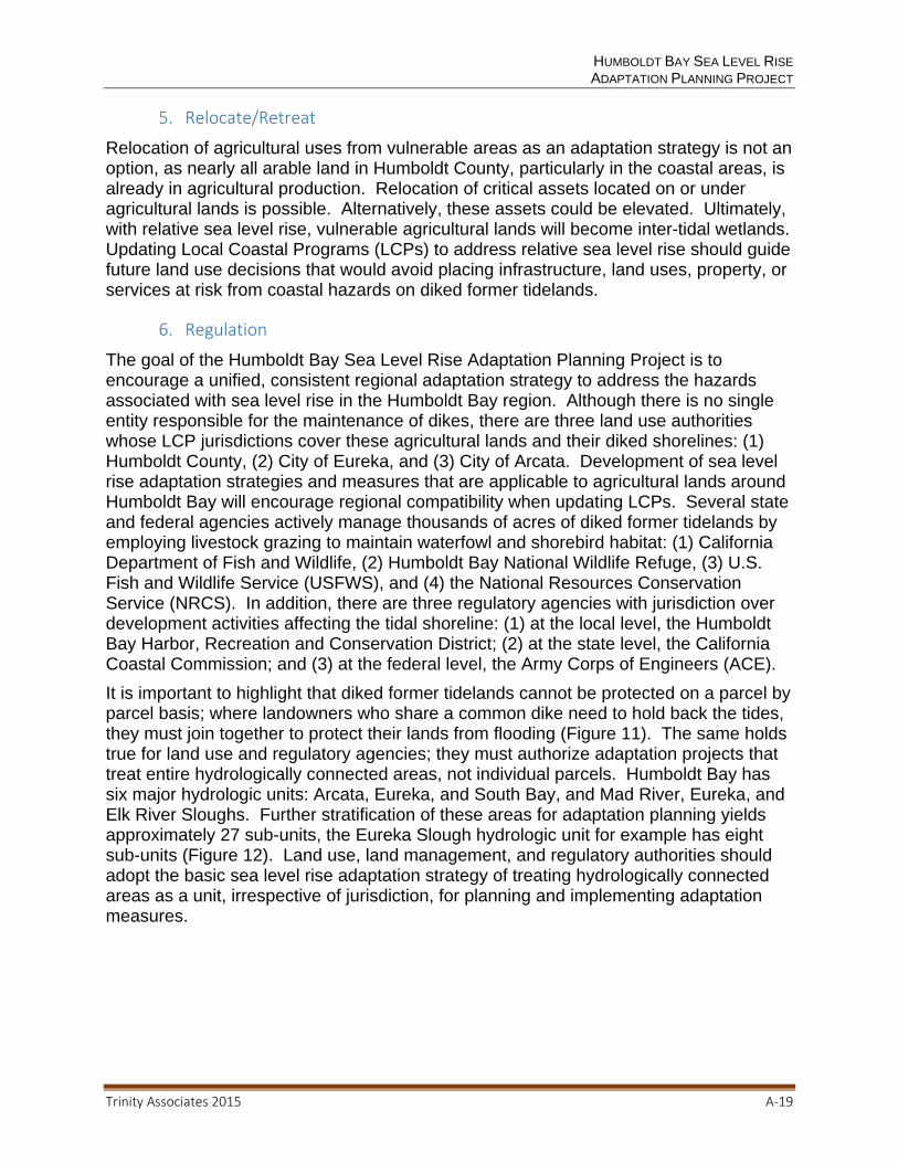
HUMBOLDT BAY SEA LEVEL RISE ADAPTATION PLANNING PROJECT
Trinity Associates 2015 A‐19
5. Relocate/Retreat
Relocation of agricultural uses from vulnerable areas as an adaptation strategy is not an option, as nearly all arable land in Humboldt County, particularly in the coastal areas, is already in agricultural production. Relocation of critical assets located on or under agricultural lands is possible. Alternatively, these assets could be elevated. Ultimately, with relative sea level rise, vulnerable agricultural lands will become inter-tidal wetlands. Updating Local Coastal Programs (LCPs) to address relative sea level rise should guide future land use decisions that would avoid placing infrastructure, land uses, property, or services at risk from coastal hazards on diked former tidelands.
6. Regulation
The goal of the Humboldt Bay Sea Level Rise Adaptation Planning Project is to encourage a unified, consistent regional adaptation strategy to address the hazards associated with sea level rise in the Humboldt Bay region. Although there is no single entity responsible for the maintenance of dikes, there are three land use authorities whose LCP jurisdictions cover these agricultural lands and their diked shorelines: (1) Humboldt County, (2) City of Eureka, and (3) City of Arcata. Development of sea level rise adaptation strategies and measures that are applicable to agricultural lands around Humboldt Bay will encourage regional compatibility when updating LCPs. Several state and federal agencies actively manage thousands of acres of diked former tidelands by employing livestock grazing to maintain waterfowl and shorebird habitat: (1) California Department of Fish and Wildlife, (2) Humboldt Bay National Wildlife Refuge, (3) U.S. Fish and Wildlife Service (USFWS), and (4) the National Resources Conservation Service (NRCS). In addition, there are three regulatory agencies with jurisdiction over development activities affecting the tidal shoreline: (1) at the local level, the Humboldt Bay Harbor, Recreation and Conservation District; (2) at the state level, the California Coastal Commission; and (3) at the federal level, the Army Corps of Engineers (ACE).
It is important to highlight that diked former tidelands cannot be protected on a parcel by parcel basis; where landowners who share a common dike need to hold back the tides, they must join together to protect their lands from flooding (Figure 11). The same holds true for land use and regulatory agencies; they must authorize adaptation projects that treat entire hydrologically connected areas, not individual parcels. Humboldt Bay has six major hydrologic units: Arcata, Eureka, and South Bay, and Mad River, Eureka, and Elk River Sloughs. Further stratification of these areas for adaptation planning yields approximately 27 sub-units, the Eureka Slough hydrologic unit for example has eight sub-units (Figure 12). Land use, land management, and regulatory authorities should adopt the basic sea level rise adaptation strategy of treating hydrologically connected areas as a unit, irrespective of jurisdiction, for planning and implementing adaptation measures.
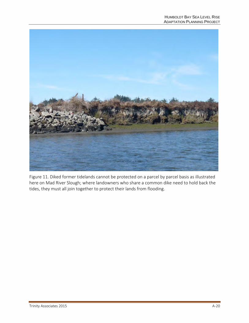
HUMBOLDT BAY SEA LEVEL RISE ADAPTATION PLANNING PROJECT
Trinity Associates 2015 A‐20
Figure 11. Diked former tidelands cannot be protected on a parcel by parcel basis as illustrated here on Mad River Slough; where landowners who share a common dike need to hold back the tides, they must all join together to protect their lands from flooding.

HUMBOLDT BAY SEA LEVEL RISE ADAPTATION PLANNING PROJECT
Trinity Associates 2015 A‐21
Figure 12. Blue shaded areas depict eight discrete hydrological sub‐units within the larger Eureka Slough hydrologic complex that are vulnerable to inundation, if the diked shoreline were to be breached or overtopped (NHE 2014b).
ADAPTATION MEASURES
Sustaining agricultural, wildlife, and other natural resource uses of low-lying agricultural lands will require development and implementation of adaptation measures. There are several adaptation measures that could increase the resiliency of these diked agricultural lands to sea level rise:
1. Dikes could be raised 2 or 3 more feet; however, this may require expanding the footprint of the dike onto the agricultural lands, which are also seasonal freshwater wetlands, unless the dike faces can be steepened with fortification.
HUMBOLDT BAY SEA LEVEL RISE ADAPTATION PLANNING PROJECT
Trinity Associates 2015 A‐22
2. Where diked shoreline reaches are exposed to wind-generated waves, the dike could be relocated/setback inland and salt or freshwater marsh plains could be created in front; the living shoreline would provide protection for the dike.
3. Retrofitting top-hinged tide gates with side-hinged tide gates and enlarging the diameter of the inlet culvert can increase the efficiency of the water control structure to drain flooded agricultural lands through a greater range of tidal elevations. Adding more tide gates can also increase the amount of drainage during a tide cycle.
4. Importing clean fill material to raise the surface elevation of compacted and subsided agricultural lands on a limited scale due to the lack of sufficient volume of suitable fill would make some lands much more resilient to rising groundwater and rising MLW and MLLW elevations which will impede stormwater runoff and convert pasture forage to more salt tolerant vegetation.
5. Constructing a large multiple tide gate or tidal dam/barrier structure at the mouth of tidal sloughs (Mad River, Eureka, and Elk River Sloughs) may be a feasible means to offer protection from tidal inundation for thousands of acres of diked former tidelands.
6. Diked former tidelands that do not have underground utilities or transportation systems to boost their intrinsic value can be enhanced as riparian wildlife habitat until the dikes are breached or overtopped rather than simply allowing these lands to become mud flats via dike breaching.
7. Because multiple landowners need to be involved in these sub-units, these landowners need to become organized and form a collaborative adaptation planning stakeholder group to successfully develop and implement adaptation measures. Perhaps the Humboldt County Resource Conservation District or Farm Bureau could assist in this planning effort.
8. Ultimately, regulatory integration will also be necessary. The NRCS and USFWS have programs that assist local agricultural landowners to sustain agricultural practices and protect wildlife habitat. These federal agencies could develop a Memorandum of Agreement with the ACE to authorize activities sanctioned by the Services to increase the resiliency of agricultural lands facing the impacts of sea level rise. The agricultural areas that are vulnerable to relative sea level rise on Humboldt Bay are subject to both the California Coastal Act and Federal Coastal Zone Management Act. Therefore, these federal Services could also prepare a general consistency determination (CD) for the Coastal Commission’s concurrence to authorize placement of fill on diked former tidelands as an adaptation measure for sustaining agricultural practices and wildlife habitat in response to relative sea level rise. The proposed CD and these physical adaptation measures would enable property owners to increase the adaptive capacity of their agricultural lands, possibly sustaining agricultural uses and wildlife habitat.
HUMBOLDT BAY SEA LEVEL RISE ADAPTATION PLANNING PROJECT
Trinity Associates 2015 A‐23
1. Regulatory Constraints to Adaptation Measures
The Coastal Act of 1976 (Act) (Public Resource Code (PRC) § 30000 et seq.), and thereby also the Federal Coastal Zone Management Act pursuant to its consistency provision, contains several policies that would constrain the implementation of some of these feasible adaptation measures:
1. While dikes could be raised, that would require increasing the footprint of the dike. Diked former tidelands are seasonal freshwater wetlands and placing fill in a coastal wetland is limited; increasing a dike’s footprint is not an allowable reason to place fill in a wetland (PRC § 30233). Increasing the height of a dike could be achieved without expanding its footprint if the shoreline is hardened with sheet piling or rock rip rap, but armoring a shoreline is not an allowable fill of a wetland if none existed previously (PRC § 30610).
2. Where diked shoreline reaches are exposed to wind generated waves, they could be relocated inland and living shorelines could be created in front to provide protection. Relocating a dike would employ current engineering standards in rebuilding a dike to appropriate and stable slopes, which would likely result in expanding the footprint of the relocated dike. This would trigger the same regulatory constraints described above.
3. Retrofitting top-hinged tide gates with side-hinged tide gates and enlarging the diameter of the inlet culvert can increase the efficiency of the water control structure to drain flooded agricultural lands through a greater range of tidal elevations. Adding more tide gates can also increase the amount of drainage during a tide cycle or from stormwater runoff. Few regulatory constraints are anticipated with this adaptation measure.
4. Importing clean fill material to raise the surface elevation of compacted and subsided agricultural lands would make these lands much more resilient to rising groundwater and rising MLW and MLLW elevations, which could flood low lying areas, and thus able to support continued grazing activities. Unfortunately, enhancing agricultural activities by placing fill to elevate the surface above groundwater or rising low tides is not an allowable fill in a coastal wetland pursuant to PRC § 30233. This adaptation measure is also counter to achieving the policy in PRC § 30230 of restoring marine resources whenever feasible. There is an inherent conflict within the Coastal Act between restoring former tidelands, a marine resource, and perpetuating agricultural uses pursuant to PRC § 30241 and 30242, which seek to protect and maintain agricultural lands from being converted to other uses. The Coastal Act anticipated the need to balance policies that are brought into conflict under unique circumstances to protect coastal resources, such as agriculture, wetlands, wildlife habitat, and coastal infrastructure, and allows the Commission to weigh the net benefit derived to coastal resources from a proposed action (PRC § 30007.5).
5. Converting diked former tidelands from seasonal or perennial freshwater wetlands to riparian habitat would increase wildlife and wetland values. But PRC § 30230, the Marine Resource policy, would require that these former tidelands be restored to the inter-tidal habitat that they once were. Unfortunately, the surface elevation of these diked former tidelands has lowered by as much as

HUMBOLDT BAY SEA LEVEL RISE ADAPTATION PLANNING PROJECT
Trinity Associates 2015 A‐24
three feet. Restoring tidal inundation would not restore salt marsh habitat that existed before diking; rather, the lower surface elevation would be tidally inundated for a greater period of time, resulting in mud flats, not salt marsh.
2. Justifying Adaptation Measures to Regulatory Constraints
Fortunately, the Act’s basic goals are to “protect, maintain, and, where feasible, enhance and restore the overall quality of the coastal zone environment and its natural and artificial resources" (PRC § 30001.5 (a)). The Act can resolve conflicting policies by seeking a balance that is the most protective of significant coastal resources (PRC § 30007.5); agricultural, wildlife lands, and critical infrastructure are significant coastal resources worthy of protection.
Increasing an agricultural dike’s footprint is not an allowable reason to place fill in a wetland (PRC § 30233). But agricultural lands are not single purpose use areas. These lands support important regional seasonal freshwater wetlands and wildlife populations, as well as protect critical regional infrastructure. On Humboldt Bay, agricultural dikes protect much more than livestock grazing. They protect seasonal freshwater wetlands and wildlife habitat from being converted to inter-tidal wetlands to the detriment of sensitive wildlife species. Pursuant to PRC § 30233, enhancing and protecting wildlife habitat is an allowable reason to place fill in a coastal wetland. If these land surfaces are not raised, they will not be able to support seasonal freshwater wetland vegetation in the face of rising groundwater and low tides thus rendering any dike enhancement moot. These dikes also protect other critical regional assets from being inundated by saltwater, such as municipal water lines, transportation corridors, pressurized gas lines, and electrical transmission towers. These critical regional assets will be very expensive to protect with other means and more expensive to relocate or elevate; it is desirable that the agricultural dikes protect these regional assets as long as possible.
Enhancing agricultural activities by placing fill to elevate the surface of the pastures above groundwater or rising low tides is also not an allowable fill in a coastal wetland pursuant to PRC § 30233. But, as discussed above, agricultural lands are not single purpose use areas. These lands support important regional seasonal freshwater wetlands and wildlife populations, as well as protect critical regional infrastructure. Restoring former salt marsh habitat will not be achieved simply by opening an area to tidal action, because these lands have compacted and subsided. Their surfaces must be raised; otherwise, these lands will become mudflats, not salt marsh.
Protecting valuable agricultural lands is also counter to achieving the policy in PRC § 30230 of restoring marine resources whenever feasible. Restoring marine resources is the goal if there are no physical, economic, or political impediments. However, these impediments do exist at many sites where agricultural lands can be sustained with the placement of fill, or where dikes offer protection for critical infrastructure and existing seasonal freshwater wetlands.
HUMBOLDT BAY SEA LEVEL RISE ADAPTATION PLANNING PROJECT
Trinity Associates 2015 A‐25
CONCLUSIONS
The diked former tidelands on Humboldt Bay are currently predominately used for agricultural uses like livestock grazing, as wildlife habitat, for utility lines, and coastal open space for recreation. These lands are vulnerable to tidal inundation from shoreline breaching or overtopping, and flooding from rising low tide elevations and rising groundwater. The present land uses are likely sustainable for decades with adaptation measures, but eventually sea level rise will flood these former tidelands. As sea level rise progresses, utilities and transportation systems located on these former tidelands will need to adapt to tidal inundation if they are to remain in their present right-of-ways, or relocate.
Adaptation planning for an asset at risk, such as the agricultural lands on Humboldt Bay, should be undertaken by a collaborative stakeholder group consisting of property owners, affected property and asset owners, people who derive benefits from this asset, LCP and regulatory authorities, and if possible, funding agencies. Successful implementation of adaptation options for these agricultural lands will likely require partnerships amongst affected stakeholders. Building on the work products produced for this Project and the deliberations of the Adaptation Planning Working Group, it is most realistic that the stakeholders of these agricultural lands at risk select adaptation strategies that are feasible for their asset at risk, and determine when adaptation options should be initiated, and how to secure funding to implement the adaptation options.
Implementing adaptation measures will require permits. The agricultural areas that are vulnerable to sea level rise on Humboldt Bay are subject to both the California Coastal Act and Federal Coastal Zone Management Act. The NRCS and USFWS have programs that can assist local agricultural landowners to sustain agricultural practices and protect wildlife habitat. The Services could prepare a general CD for the Coastal Commission’s concurrence to authorize placement of fill on diked former tidelands in the context of implementing adaptation measures for sustaining agricultural practices, wildlife habitat, and protecting critical infrastructure in response to relative sea level rise. The proposed CD and these physical adaptation measures would enable property owners to increase the resiliency of their agricultural lands, possibly sustaining agricultural uses and seasonal freshwater wetland habitats for several decades, and put these lands in a much better position to be reclaimed as salt marsh by the Bay in the future.
HUMBOLDT BAY SEA LEVEL RISE ADAPTATION PLANNING PROJECT
Trinity Associates 2015 A‐26
REFERENCES
California Coastal Commission. 2013. Draft Sea-Level Rise Policy Document.
Cascadia Geosciences. 2013. Tectonic land level changes and their contributions to sea-level rise, Humboldt Bay region, Northern California; 2013 Status Update.
Coastal and Ocean Working Group of the California Climate Action Team. 2013. State of California Sea-Level Rise Guidance Document. Prepared for Ocean Protection council.
Laird, Aldaron and Brian Powell. 2013. Humboldt Bay shoreline inventory, mapping, and sea level rise vulnerability assessment, with an Addendum: Shoreline Vulnerability Ratings. Prepared for the California State Coastal Conservancy.
Northern Hydrology and Engineering. 2013. Sea level rise in Northernmost California, presentation to public meeting of the Humboldt Bay sea level rise adaptation planning working group; November 2013.
Northern Hydrology and Engineering. 2014a. Estimates of local or relative sea level rise for Humboldt Bay region. Prepared for the California State Coastal Conservancy.
Northern Hydrology and Engineering. 2014b. Data release for the Humboldt Bay sea level rise vulnerability assessment: Humboldt Bay sea level rise inundation mapping. Prepared for the California State Coastal Conservancy.
Northern Hydrology and Engineering. 2014c. Humboldt Bay Sea Level Rise Hydrodynamic Modeling and Inundation Vulnerability Mapping. Prepared for the California State Coastal Conservancy.
Russell, Nicole and Gary Griggs. 2012. Adapting to sea level rise: A guide for California’s coastal communities. University of California, Santa Cruz.
Sullivan, Robert. 2013. Back to the Future: Programmatic Sea Level Rise Vulnerability Assessment with Recommendation’s for Fay Slough, Mad River Slough, and Elk River Slough Wildlife Areas. Prepared for California Department of Fish and Wildlife.
HUMBOLDT BAY SEA LEVEL RISE ADAPTATION PLANNING PROJECT
Trinity Associates 2015 B‐1
APPENDIX B: How Can the Highway 101 Corridor on Humboldt Bay Adapt to Sea Level Rise?

HUMBOLDT BAY SEA LEVEL RISE ADAPTATION PLANNING PROJECT
Trinity Associates 2015 B‐2

How Can the Highway 101 Corridor on Humboldt Bay Adapt to Sea Level Rise?
Prepared by:
Aldaron Laird Trinity Associates
980 7th Street, Suite K Arcata, CA 95521
February 2015
HUMBOLDT BAY SEA LEVEL RISE ADAPTATION PLANNING PROJECT
Trinity Associates 2015 B‐4
Acknowledgements
Funding by: California Coastal Conservancy
Sponsored by: Coastal Ecosystems Institute of Northern California
Adaptation Planning Working Group Co-Lead Agencies:
Humboldt Bay Harbor Conservation, and Recreation District Humboldt County Public Works Department (Environmental Services Division)
Sea Level Rise Adaption Planning Consultant: Trinity Associates
Humboldt Bay Sea Level Rise Hydrodynamic Modeling and Inundation Vulnerability Mapping: Northern Hydrology and Engineering
Note: This report was prepared by Trinity Associates and does not necessarily reflect the views of the agencies and organizations that participated in the Humboldt Bay Sea Level Rise Adaptation Planning Group.

HUMBOLDT BAY SEA LEVEL RISE ADAPTATION PLANNING PROJECT
Trinity Associates 2015 B‐5
TABLE OF CONTENTS
BACKGROUND .............................................................................................................. 6
VULNERABILITY ASSESSMENT ................................................................................... 9
1. Exposure Assessment ......................................................................................... 10
a. Existing Conditions ........................................................................................... 25
b. 2014 to 2050: 0.5 meter of Sea Level Rise ................................................... 34
c. 2050 to 2100: 1.0 meter of Sea Level Rise ...................................................... 41
2. Sensitivity Assessment ........................................................................................ 46
3. Significance Assessment ..................................................................................... 46
ADAPTATION STRATEGIES ........................................................................................ 47
Planning for Hydrologic Sub-units.............................................................................. 47
Planning Timeframes ................................................................................................. 48
Adaptation Options .................................................................................................... 48
1. No Action ............................................................................................................. 48
2. Protect ................................................................................................................. 49
3. Accommodate ..................................................................................................... 51
4. Relocate .............................................................................................................. 52
CONCLUSIONS ............................................................................................................ 53
REFERENCES .............................................................................................................. 54
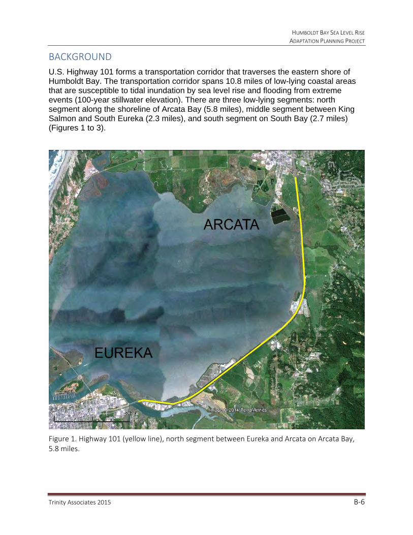
HUMBOLDT BAY SEA LEVEL RISE ADAPTATION PLANNING PROJECT
Trinity Associates 2015 B‐6
BACKGROUND
U.S. Highway 101 forms a transportation corridor that traverses the eastern shore of Humboldt Bay. The transportation corridor spans 10.8 miles of low-lying coastal areas that are susceptible to tidal inundation by sea level rise and flooding from extreme events (100-year stillwater elevation). There are three low-lying segments: north segment along the shoreline of Arcata Bay (5.8 miles), middle segment between King Salmon and South Eureka (2.3 miles), and south segment on South Bay (2.7 miles) (Figures 1 to 3).
Figure 1. Highway 101 (yellow line), north segment between Eureka and Arcata on Arcata Bay, 5.8 miles.
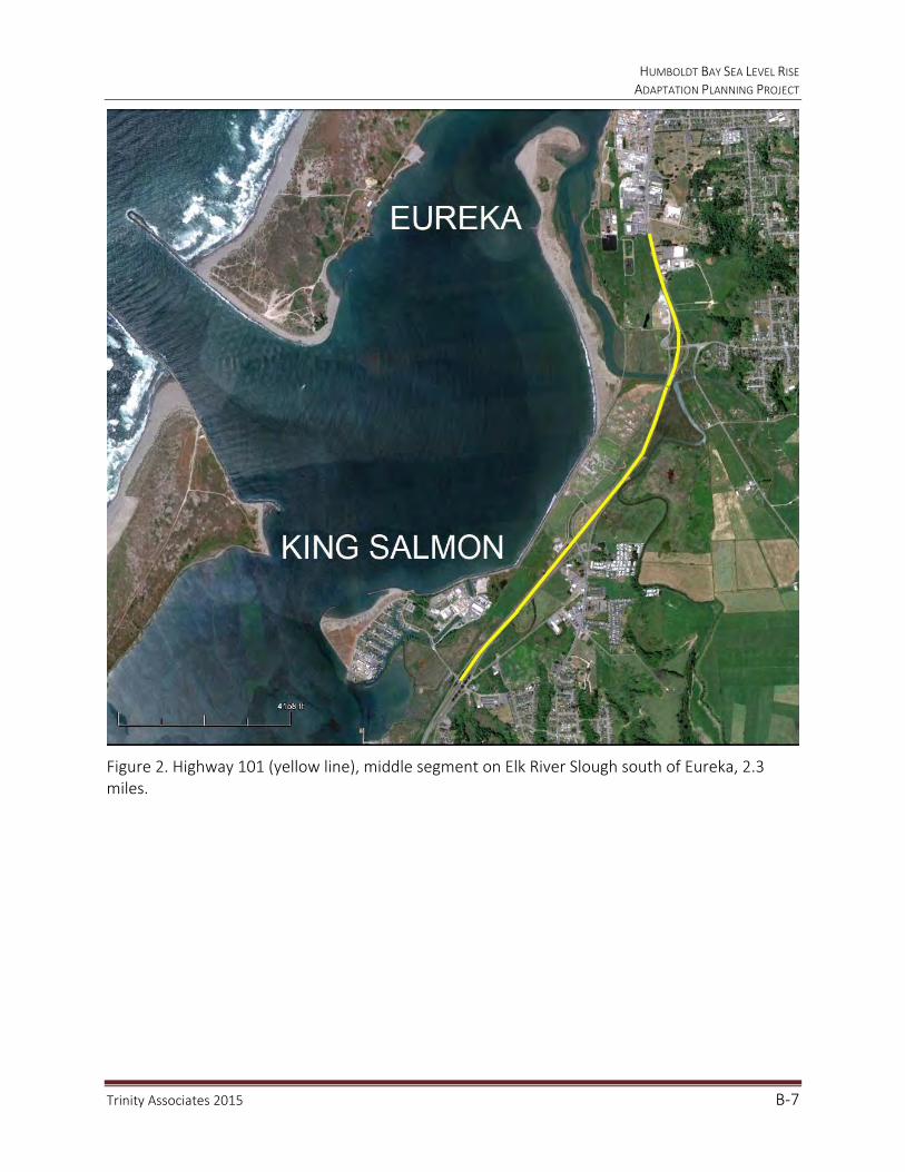
HUMBOLDT BAY SEA LEVEL RISE ADAPTATION PLANNING PROJECT
Trinity Associates 2015 B‐7
Figure 2. Highway 101 (yellow line), middle segment on Elk River Slough south of Eureka, 2.3 miles.

HUMBOLDT BAY SEA LEVEL RISE ADAPTATION PLANNING PROJECT
Trinity Associates 2015 B‐8
Figure 3. Highway 101 (yellow line), south segment on South Bay from Hookton Road to Tompkins Hill Road, 2.7 miles.

HUMBOLDT BAY SEA LEVEL RISE ADAPTATION PLANNING PROJECT
Trinity Associates 2015 B‐9
The Humboldt Bay Sea Level Rise Adaptation Planning Project (Project), funded by the California Coastal Conservancy, includes a vulnerability assessment that entails: (1) a shoreline inventory, mapping, and vulnerability assessment (Laird and Powell 2013); and (2) inundation/flood vulnerability modeling and mapping (NHE 2014). The Project has also convened an adaptation planning working group (APWG) to develop a regional adaptation plan for Humboldt Bay (2013–2014). The adaptation plan being prepared for the Project provides site-specific shoreline and inundation/flood vulnerability assessment and regional adaptation planning information for the development of adaptation strategies and options for critical assets, such as the Highway 101 transportation corridor on Humboldt Bay. This transportation corridor includes US Highway 101, Northwest Pacific Railroad, and the proposed Humboldt Bay Trail.
VULNERABILITY ASSESSMENT
The Project utilized a vulnerability assessment methodology described in the California Adaptation Planning Guide (2012) that has been modified in the process of developing an adaptation plan for Humboldt Bay. The Project vulnerability assessment methodology entails identifying areas and assets that are vulnerable to sea level rise, then assessing asset exposure, sensitivity, and significance (Figure 4).
Figure 4. Vulnerability assessment methodology entails assessing exposure, sensitivity, and significance.
EXPOSURE
How/
Impacts
Where/
What
When
Magnitude
SENSITIVITY
Resiliency
Adaptive
Capacity
SIGNIFICANCE
Consequence
Prioritize

HUMBOLDT BAY SEA LEVEL RISE ADAPTATION PLANNING PROJECT
Trinity Associates 2015 B‐10
1. Exposure Assessment
The exposure assessment is based on the Project’s GIS shoreline vulnerability assessment (Laird and Powell 2013) and inundation/flood vulnerability modeling/mapping for Humboldt Bay (NHE 2014b) that covers the three low-lying segments of the Highway 101 corridor.
Sea level rise will impact transportation assets that are located in low-lying coastal areas. These impacts can manifest directly, through erosion of highway fill/embankments or bridge abutments, and/or inundation of highway surfaces and drainage structures. Impacts can also manifest indirectly through impacts to road fill/embankments or surfaces from rising groundwater and saltwater intrusion, which could corrode underground structures such as culverts. When assessing exposure to sea level rise for planning purposes, it is useful to differentiate between permanent saltwater inundations versus infrequent extreme hazard floods.
The first phase of the Project inventoried, mapped, and assessed the vulnerability of the current shoreline of Humboldt Bay. Highway 101, for most of its length on Humboldt Bay, does not actually form a shoreline; instead publicly and privately owned structures create 16.4 miles of protective shorelines to the west and east of Highway 101. These shorelines primarily consist of a publicly owned but unused and unmaintained railroad grade, spanning 5.3 miles, and publicly and privately owned and maintained dikes over 11.1 miles (Figures 5 through 8).
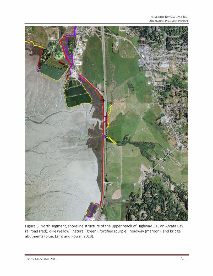
HUMBOLDT BAY SEA LEVEL RISE ADAPTATION PLANNING PROJECT
Trinity Associates 2015 B‐11
Figure 5. North segment, shoreline structure of the upper reach of Highway 101 on Arcata Bay: railroad (red), dike (yellow), natural (green), fortified (purple), roadway (maroon), and bridge abutments (blue; Laird and Powell 2013).

HUMBOLDT BAY SEA LEVEL RISE ADAPTATION PLANNING PROJECT
Trinity Associates 2015 B‐12
Figure 6. North segment, shoreline structure of the lower reach of Highway 101 on Arcata Bay: railroad (red), dike (yellow), fill (purple), and natural (green; Laird and Powell 2013).
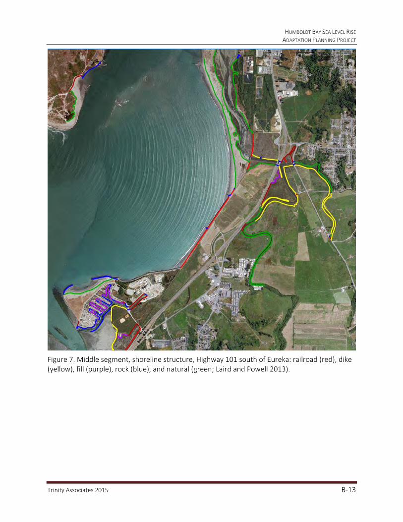
HUMBOLDT BAY SEA LEVEL RISE ADAPTATION PLANNING PROJECT
Trinity Associates 2015 B‐13
Figure 7. Middle segment, shoreline structure, Highway 101 south of Eureka: railroad (red), dike (yellow), fill (purple), rock (blue), and natural (green; Laird and Powell 2013).

HUMBOLDT BAY SEA LEVEL RISE ADAPTATION PLANNING PROJECT
Trinity Associates 2015 B‐14
Figure 8. South segment, shoreline structure of Highway 101 on South Bay: railroad (red), dike (yellow), rock (blue), and tidegate (Laird and Powell 2013).

HUMBOLDT BAY SEA LEVEL RISE ADAPTATION PLANNING PROJECT
Trinity Associates 2015 B‐15
At present, 9.6 miles of shoreline protecting Highway 101 have been rated highly vulnerable to breaching because of their low elevation. They can be overtopped by either extreme tides (100-year event) or annual king tides and/or storm surges that rise up 2 feet (9.74 feet NAVD 88 as measured at NOAA’s North Spit tide gage) or more above the tidal baseline elevation (Figures 9 through 12). The Project’s tidal baseline is mean monthly maximum water (MMMW) elevation (7.74 feet). The bay-wide 100-year event is 2.25 feet higher than the bay-wide average MMMW (NHE 2014c). Moderate vulnerability rating was given to shoreline segments that are 2 to 4 feet above MMMW elevations and low for segments that are greater than 4 feet above. Eroding shoreline segments at any elevation were rated highly vulnerable (Laird and Powell 2013).

HUMBOLDT BAY SEA LEVEL RISE ADAPTATION PLANNING PROJECT
Trinity Associates 2015 B‐16
Figure 9. North segment, shoreline vulnerability rating of the upper reach of Highway 101 on Arcata Bay: high (red), moderate (yellow), and low (green; Laird and Powell 2013).
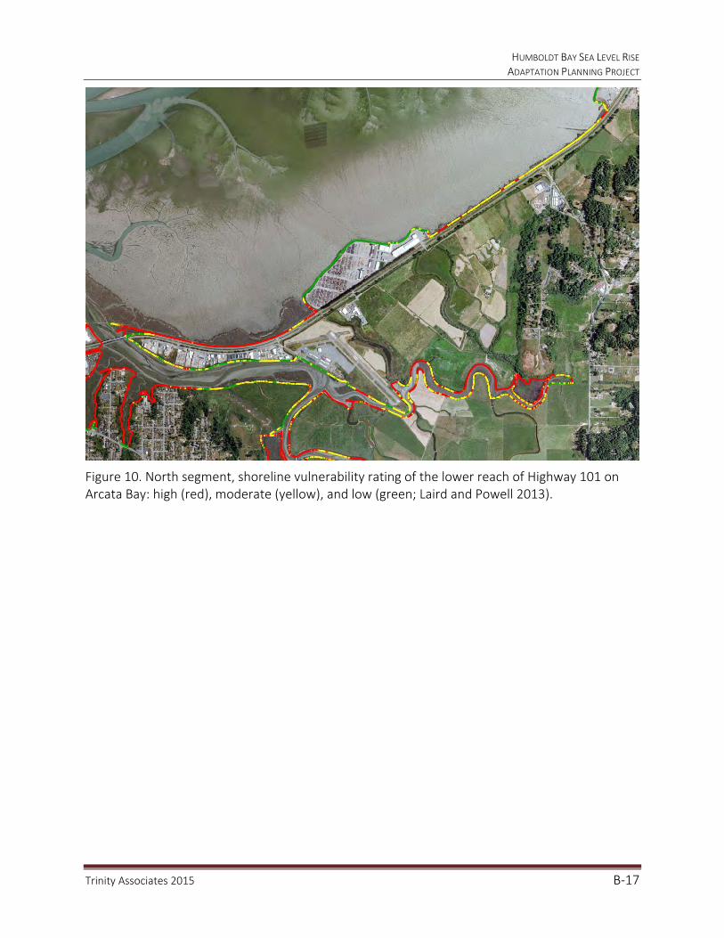
HUMBOLDT BAY SEA LEVEL RISE ADAPTATION PLANNING PROJECT
Trinity Associates 2015 B‐17
Figure 10. North segment, shoreline vulnerability rating of the lower reach of Highway 101 on Arcata Bay: high (red), moderate (yellow), and low (green; Laird and Powell 2013).

HUMBOLDT BAY SEA LEVEL RISE ADAPTATION PLANNING PROJECT
Trinity Associates 2015 B‐18
Figure 11. Middle segment, shoreline vulnerability rating, Highway 101 south of Eureka: high (red), moderate (yellow), and low (green) (Laird and Powell 2013).
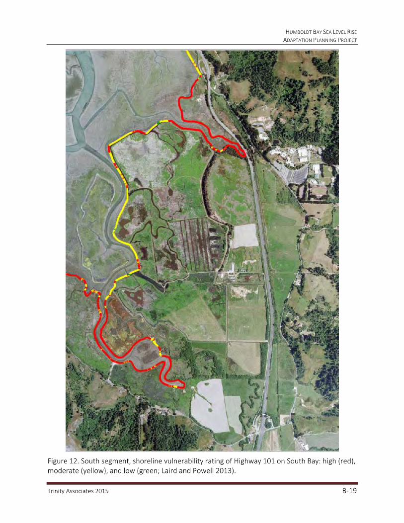
HUMBOLDT BAY SEA LEVEL RISE ADAPTATION PLANNING PROJECT
Trinity Associates 2015 B‐19
Figure 12. South segment, shoreline vulnerability rating of Highway 101 on South Bay: high (red), moderate (yellow), and low (green; Laird and Powell 2013).

HUMBOLDT BAY SEA LEVEL RISE ADAPTATION PLANNING PROJECT
Trinity Associates 2015 B‐20
The shorelines to the west and east of Highway 101 protect the corridor from tidal inundation, and also have public and privately owned and maintained tide gates. In the three low-lying segments, Highway 101 traverses several tributaries (Gannon-Beith Creeks, Jacoby Creek, Washington-Rocky Gulch, Freshwater Creek, Elk River, and Salmon Creek) that drain watersheds to the east. Stormwater runoff from these streams, particularly during high tides, can overwhelm water control and drainage structures, resulting in overbank flows that flood areas bordering Highway 101 to the east (Figure 13).
Figure 13. North segment of Highway 101 traverses several tributaries and streams to Arcata Bay that convey stormwater runoff and can flood land to the east of Highway 101.
Under MMMW conditions, if the protective shorelines to the west and east are compromised by breaching or overtopping, Highway 101 would become a causeway, similar in function to a dike, traversing the three low-lying segments on Humboldt Bay. The Highway would continue as a causeway until it became inundated by rising tides. In contrast, a viaduct would be an elevated roadway that allows water to pass beneath. If the water control and drainage structures located in the protective shoreline to the east or beneath Highway 101 fail or are impaired, flooding of lands behind the protective shorelines may occur, which can flood the road prism and surface of Highway 101.

HUMBOLDT BAY SEA LEVEL RISE ADAPTATION PLANNING PROJECT
Trinity Associates 2015 B‐21
Many of the low-lying lands adjacent to Humboldt Bay are vulnerable to tidal inundation and rising groundwater because they are former tidelands and therefore lie within the tide range. Additionally, these lands are at risk of inundation and flooding as a consequence of historical land uses, subsidence, and from sea level rise. In 1870, when the U.S. Coast Survey first mapped Humboldt Bay, it encompassed 27,000 acres. Today, Humboldt Bay occupies 17,000 acres. From 1890 to 1910, approximately 9,000 acres of salt marsh on Humboldt Bay were diked off, drained, and converted to agricultural uses. Many of the critical assets for the Humboldt Bay region, including the Highway 101 corridor, were subsequently located on these diked former tidelands, which have compacted by as much as 3 feet due to oxidation of organic material in the former salt marsh soil. Currently, 75 percent of the shoreline on Humboldt Bay is artificial, composed mostly of earthen dikes on 41 miles and railroad grade on 11 miles. If these dikes and railroad grades were breached or overtopped today, Humboldt Bay could expand by 52 percent (8,840 acres) in areal extent, inundating nearly 9,000 acres of former salt marsh. In addition, if the shoreline fails, sea level rise to 6.56 feet (2.0 meters) will increase the footprint of Humboldt Bay by 22 percent (3,740 acres) for a cumulative total of 74 percent (12,580 acres) (Figure 14). The rate of increase with sea level rise reflects the steeper upland topography adjacent to the low-lying former tidelands. While the extent of the area at risk will not change rapidly, those areas in the existing hazard zone will likely be flooded more frequently and to greater depth, increasing the risk to assets in those areas.
Figure 14. Percent cumulative increase in Humboldt Bay’s footprint as a result of shoreline failure and sea level rise ( of 1.6 feet, 3.3 feet, 4.9 feet, and 6.6 feet) (SLR, NHE 2014b).
52%
62%
72%
81%88%
0%
10%
20%
30%
40%
50%
60%
70%
80%
90%
100%
ExistingConditions
0.5M SLR 1.0M SLR 1.5M SLR 2.0M SLR
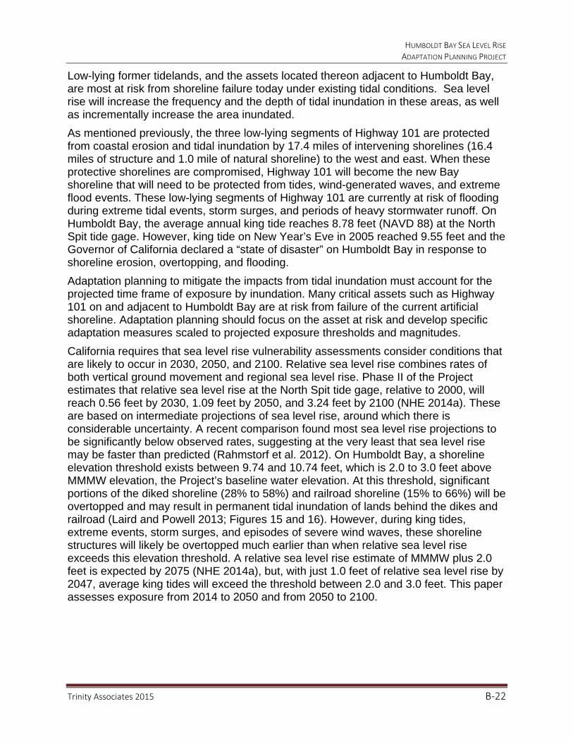
HUMBOLDT BAY SEA LEVEL RISE ADAPTATION PLANNING PROJECT
Trinity Associates 2015 B‐22
Low-lying former tidelands, and the assets located thereon adjacent to Humboldt Bay, are most at risk from shoreline failure today under existing tidal conditions. Sea level rise will increase the frequency and the depth of tidal inundation in these areas, as well as incrementally increase the area inundated.
As mentioned previously, the three low-lying segments of Highway 101 are protected from coastal erosion and tidal inundation by 17.4 miles of intervening shorelines (16.4 miles of structure and 1.0 mile of natural shoreline) to the west and east. When these protective shorelines are compromised, Highway 101 will become the new Bay shoreline that will need to be protected from tides, wind-generated waves, and extreme flood events. These low-lying segments of Highway 101 are currently at risk of flooding during extreme tidal events, storm surges, and periods of heavy stormwater runoff. On Humboldt Bay, the average annual king tide reaches 8.78 feet (NAVD 88) at the North Spit tide gage. However, king tide on New Year’s Eve in 2005 reached 9.55 feet and the Governor of California declared a “state of disaster” on Humboldt Bay in response to shoreline erosion, overtopping, and flooding.
Adaptation planning to mitigate the impacts from tidal inundation must account for the projected time frame of exposure by inundation. Many critical assets such as Highway 101 on and adjacent to Humboldt Bay are at risk from failure of the current artificial shoreline. Adaptation planning should focus on the asset at risk and develop specific adaptation measures scaled to projected exposure thresholds and magnitudes.
California requires that sea level rise vulnerability assessments consider conditions that are likely to occur in 2030, 2050, and 2100. Relative sea level rise combines rates of both vertical ground movement and regional sea level rise. Phase II of the Project estimates that relative sea level rise at the North Spit tide gage, relative to 2000, will reach 0.56 feet by 2030, 1.09 feet by 2050, and 3.24 feet by 2100 (NHE 2014a). These are based on intermediate projections of sea level rise, around which there is considerable uncertainty. A recent comparison found most sea level rise projections to be significantly below observed rates, suggesting at the very least that sea level rise may be faster than predicted (Rahmstorf et al. 2012). On Humboldt Bay, a shoreline elevation threshold exists between 9.74 and 10.74 feet, which is 2.0 to 3.0 feet above MMMW elevation, the Project’s baseline water elevation. At this threshold, significant portions of the diked shoreline (28% to 58%) and railroad shoreline (15% to 66%) will be overtopped and may result in permanent tidal inundation of lands behind the dikes and railroad (Laird and Powell 2013; Figures 15 and 16). However, during king tides, extreme events, storm surges, and episodes of severe wind waves, these shoreline structures will likely be overtopped much earlier than when relative sea level rise exceeds this elevation threshold. A relative sea level rise estimate of MMMW plus 2.0 feet is expected by 2075 (NHE 2014a), but, with just 1.0 feet of relative sea level rise by 2047, average king tides will exceed the threshold between 2.0 and 3.0 feet. This paper assesses exposure from 2014 to 2050 and from 2050 to 2100.
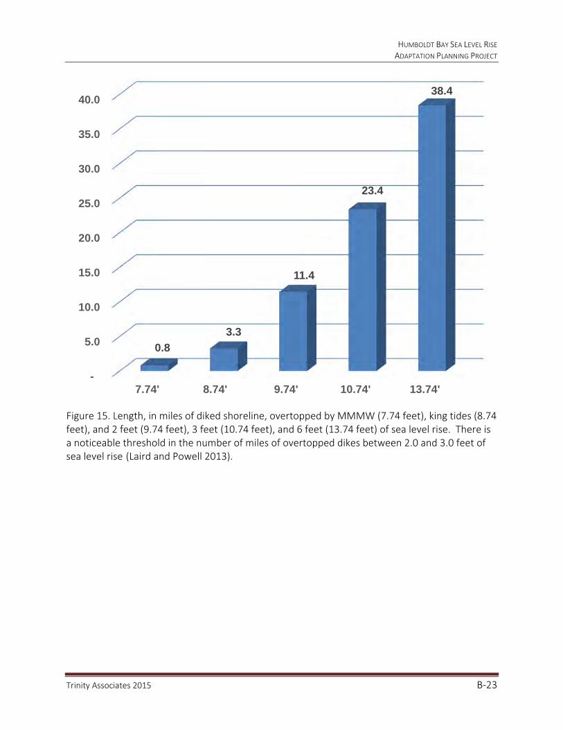
HUMBOLDT BAY SEA LEVEL RISE ADAPTATION PLANNING PROJECT
Trinity Associates 2015 B‐23
Figure 15. Length, in miles of diked shoreline, overtopped by MMMW (7.74 feet), king tides (8.74 feet), and 2 feet (9.74 feet), 3 feet (10.74 feet), and 6 feet (13.74 feet) of sea level rise. There is a noticeable threshold in the number of miles of overtopped dikes between 2.0 and 3.0 feet of sea level rise (Laird and Powell 2013).
-
5.0
10.0
15.0
20.0
25.0
30.0
35.0
40.0
7.74' 8.74' 9.74' 10.74' 13.74'
0.8
3.3
11.4
23.4
38.4
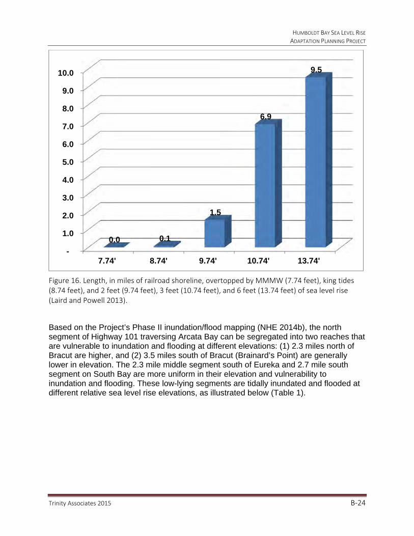
HUMBOLDT BAY SEA LEVEL RISE ADAPTATION PLANNING PROJECT
Trinity Associates 2015 B‐24
Figure 16. Length, in miles of railroad shoreline, overtopped by MMMW (7.74 feet), king tides (8.74 feet), and 2 feet (9.74 feet), 3 feet (10.74 feet), and 6 feet (13.74 feet) of sea level rise (Laird and Powell 2013).
Based on the Project’s Phase II inundation/flood mapping (NHE 2014b), the north segment of Highway 101 traversing Arcata Bay can be segregated into two reaches that are vulnerable to inundation and flooding at different elevations: (1) 2.3 miles north of Bracut are higher, and (2) 3.5 miles south of Bracut (Brainard’s Point) are generally lower in elevation. The 2.3 mile middle segment south of Eureka and 2.7 mile south segment on South Bay are more uniform in their elevation and vulnerability to inundation and flooding. These low-lying segments are tidally inundated and flooded at different relative sea level rise elevations, as illustrated below (Table 1).
-
1.0
2.0
3.0
4.0
5.0
6.0
7.0
8.0
9.0
10.0
7.74' 8.74' 9.74' 10.74' 13.74'
0.0 0.1
1.5
6.9
9.5

HUMBOLDT BAY SEA LEVEL RISE ADAPTATION PLANNING PROJECT
Trinity Associates 2015 B‐25
Table 1. Shoreline segment sea level rise and flood impacts: 2014–2030, 2030–2050, and 2050–2100. Bold indicates flooding/inundation of the Highway 101 road surface.
a. Existing Conditions
This report treats sea level rise (tidal) inundation as a permanent condition separately from flooding from extreme events (100 year stillwater elevation), which is treated as a temporary and unpredictable condition. The tidal inundation vulnerability and flood mapping indicate areas that are vulnerable if the protective shoreline structures are breached or overtopped, not areas that are currently inundated (NHE 2014b). Existing conditions were modeled using MMMW (7.74 feet) as the base tidal elevation, with the assumption that current shoreline protection was no longer functioning. The inundation vulnerability maps show that much of the former tidal lands that are currently protected, especially lands to the east of Highway 101, would be inundated at MMMW if the current shoreline protection were not in place (Figures 17–20). During a 100 year event and MMMW would rise to 9.99 feet which would flood both south and north bound lanes of Highway 101 from Airport Road to Indianola Road on Arcata Bay, and South Bay, (Figures 21-24).
SHORELINE SEGMENTS
2015‒2030 MMMW + Shoreline
Breaches
2030‒2050 MMMW + 0.5 meters
2050‒2100 MMMW + 1.0 meters
Tidally inundates road embankments and adjacent lands
Tidally inundates road embankments and adjacent lands
Tidally inundates significant portions of north and south bound lanes
100-year event floods road embankments and adjacent lands
100-year event floods north and south bound lanes
Tidally inundates highway embankments and adjacent lands
Tidally inundates north and south bound lanes
100-year event floods north and south bound lanes
Tidally inundates road embankments and adjacent lands
Tidally inundates road embankments and adjacent lands
Tidally inundates significant portions of north and south bound lanes
100-year event floods road embankments and adjacent lands
100-year event floods north and south bound lanes
Tidally inundates portions of north and south bound lanes
Tidally inundates north and south bound lanes
100 year event floods north and south bound lanes
North Segment: Upper Arcata Bay
North Segment: Lower Arcata Bay
Middle Segment
South Segment
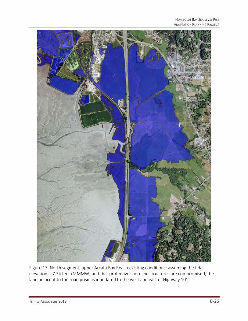
HUMBOLDT BAY SEA LEVEL RISE ADAPTATION PLANNING PROJECT
Trinity Associates 2015 B‐26
Figure 17. North segment, upper Arcata Bay Reach existing conditions: assuming the tidal elevation is 7.74 feet (MMMW) and that protective shoreline structures are compromised, the land adjacent to the road prism is inundated to the west and east of Highway 101.

HUMBOLDT BAY SEA LEVEL RISE ADAPTATION PLANNING PROJECT
Trinity Associates 2015 B‐27
Figure 18. North segment, lower Arcata Bay Reach existing conditions: assuming the tidal elevation is 7.74 feet (MMMW) and that protective shoreline structures are compromised, the land adjacent to the road prism is inundated to the west and east of Highway 101. Erosion of the road embankment is possible if exposed to waves, and integrity may be compromised prior to inundation or flooding. Erosion related impacts will increase as water depth increases.

HUMBOLDT BAY SEA LEVEL RISE ADAPTATION PLANNING PROJECT
Trinity Associates 2015 B‐28
Figure 19. Middle segment, south of Eureka existing conditions: assuming the tidal elevation is 7.74 feet (MMMW) and that protective shoreline structures are compromised, the land adjacent to the road prism is inundated to the west and east of Highway 101.
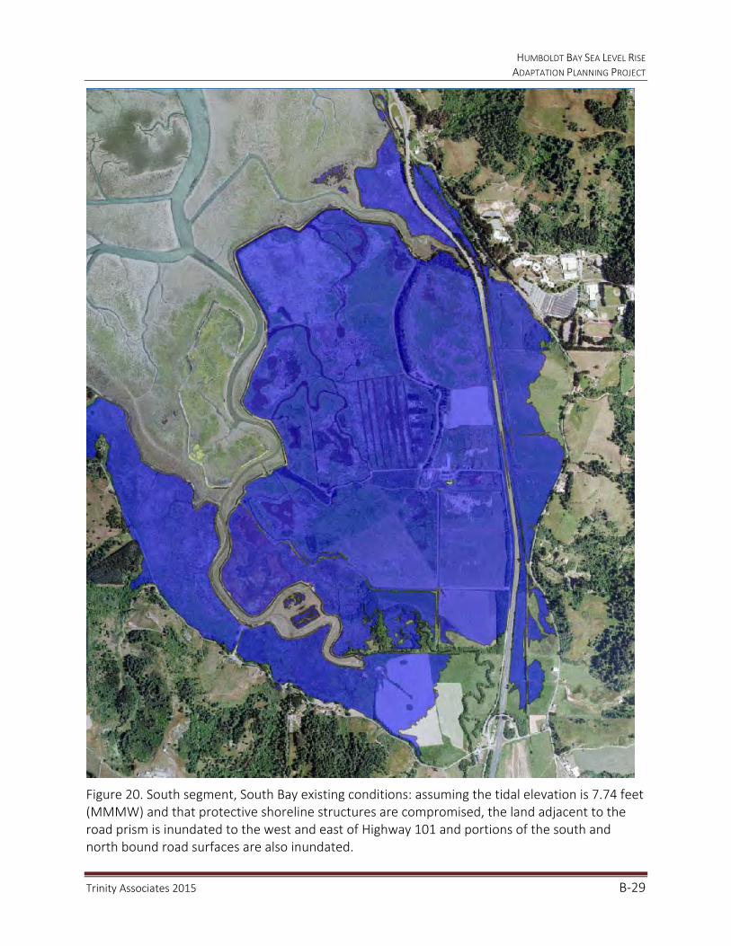
HUMBOLDT BAY SEA LEVEL RISE ADAPTATION PLANNING PROJECT
Trinity Associates 2015 B‐29
Figure 20. South segment, South Bay existing conditions: assuming the tidal elevation is 7.74 feet (MMMW) and that protective shoreline structures are compromised, the land adjacent to the road prism is inundated to the west and east of Highway 101 and portions of the south and north bound road surfaces are also inundated.

HUMBOLDT BAY SEA LEVEL RISE ADAPTATION PLANNING PROJECT
Trinity Associates 2015 B‐30
Figure 21. North segment, upper Arcata Bay Reach existing conditions: assuming the tidal elevation is 9.99 feet (MMMW+100‐year stillwater level) and that protective shoreline structures are compromised, the land adjacent to the road prism is flooded to the west and east of Highway 101.
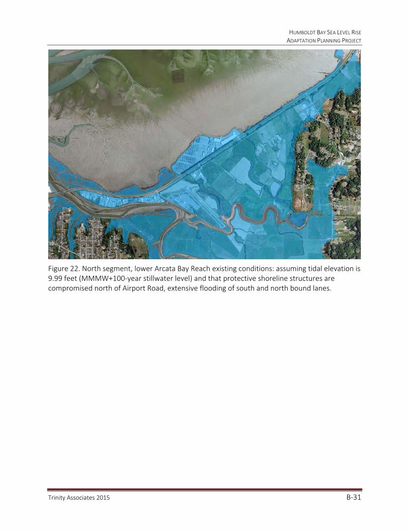
HUMBOLDT BAY SEA LEVEL RISE ADAPTATION PLANNING PROJECT
Trinity Associates 2015 B‐31
Figure 22. North segment, lower Arcata Bay Reach existing conditions: assuming tidal elevation is 9.99 feet (MMMW+100‐year stillwater level) and that protective shoreline structures are compromised north of Airport Road, extensive flooding of south and north bound lanes.
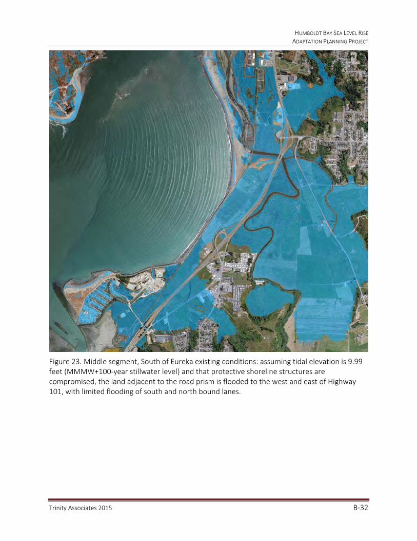
HUMBOLDT BAY SEA LEVEL RISE ADAPTATION PLANNING PROJECT
Trinity Associates 2015 B‐32
Figure 23. Middle segment, South of Eureka existing conditions: assuming tidal elevation is 9.99 feet (MMMW+100‐year stillwater level) and that protective shoreline structures are compromised, the land adjacent to the road prism is flooded to the west and east of Highway 101, with limited flooding of south and north bound lanes.

HUMBOLDT BAY SEA LEVEL RISE ADAPTATION PLANNING PROJECT
Trinity Associates 2015 B‐33
Figure 24. South segment, South Bay existing conditions: assuming the tidal elevation is 9.99 feet (MMMW+100‐year stillwater level) and that protective shoreline structures are compromised, the land adjacent to the road prism is flooded to the west and east of Highway 101, with extensive flooding of south and north bound lanes.

HUMBOLDT BAY SEA LEVEL RISE ADAPTATION PLANNING PROJECT
Trinity Associates 2015 B‐34
b. 2014 to 2050: 0.5 meter of Sea Level Rise
Half a meter of sea level rise is near the high projection for 2050 (0.6 meters/1.9 feet) and combined with MMMW would rise to 9.38 feet. The elevation of MMMW plus 0.5 meters of sea level rise is slightly higher than the elevation of the 100 year event of 9.38 feet. Areas that would be infrequently affected by the 100 year extreme event will become tidally inundated much more frequently by 2050 if the projected 0.3 to 0.6 meters of sea level rise occurs. Figures 21-24 illustrate inundation areas for the 100 year extreme event, which are very similar in areal extent to the 0.5 meter tidal inundation areas illustrated in Figures 25-28, the difference will be in the frequency and depth of inundation. Figures 29-30 illustrate that south and north bound lanes of Highway 101 in the north reach of Arcata Bay and the low-lying area south of Eureka are vulnerable to flooding during 100 year extreme events with 0.5 meters of sea level rise (11.63 feet).
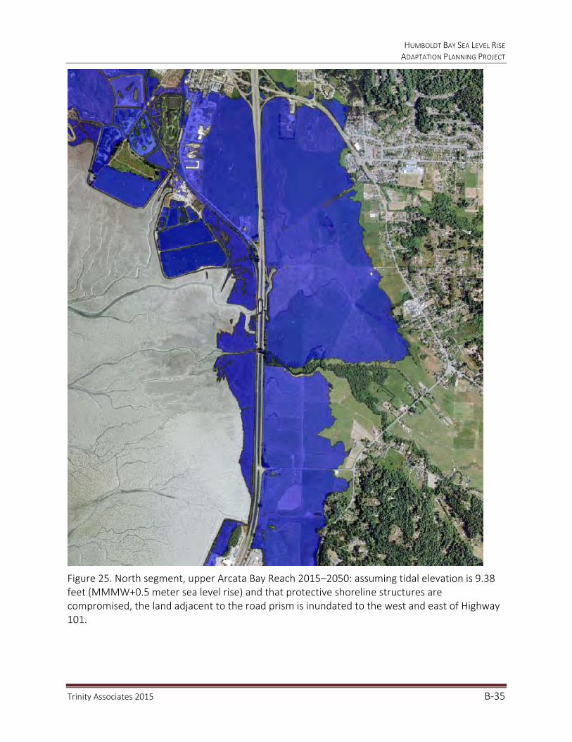
HUMBOLDT BAY SEA LEVEL RISE ADAPTATION PLANNING PROJECT
Trinity Associates 2015 B‐35
Figure 25. North segment, upper Arcata Bay Reach 2015–2050: assuming tidal elevation is 9.38 feet (MMMW+0.5 meter sea level rise) and that protective shoreline structures are compromised, the land adjacent to the road prism is inundated to the west and east of Highway 101.

HUMBOLDT BAY SEA LEVEL RISE ADAPTATION PLANNING PROJECT
Trinity Associates 2015 B‐36
Figure 26. North segment, lower Arcata Bay Reach 2015–2050: assuming the tidal elevation is 9.38 feet (MMMW+0.5 meter sea level rise) and that protective shoreline structures are compromised, both south and north bound lanes are inundated.
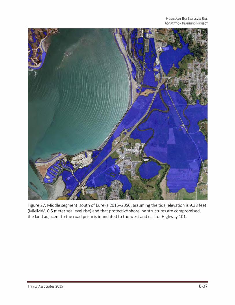
HUMBOLDT BAY SEA LEVEL RISE ADAPTATION PLANNING PROJECT
Trinity Associates 2015 B‐37
Figure 27. Middle segment, south of Eureka 2015–2050: assuming the tidal elevation is 9.38 feet (MMMW+0.5 meter sea level rise) and that protective shoreline structures are compromised, the land adjacent to the road prism is inundated to the west and east of Highway 101.
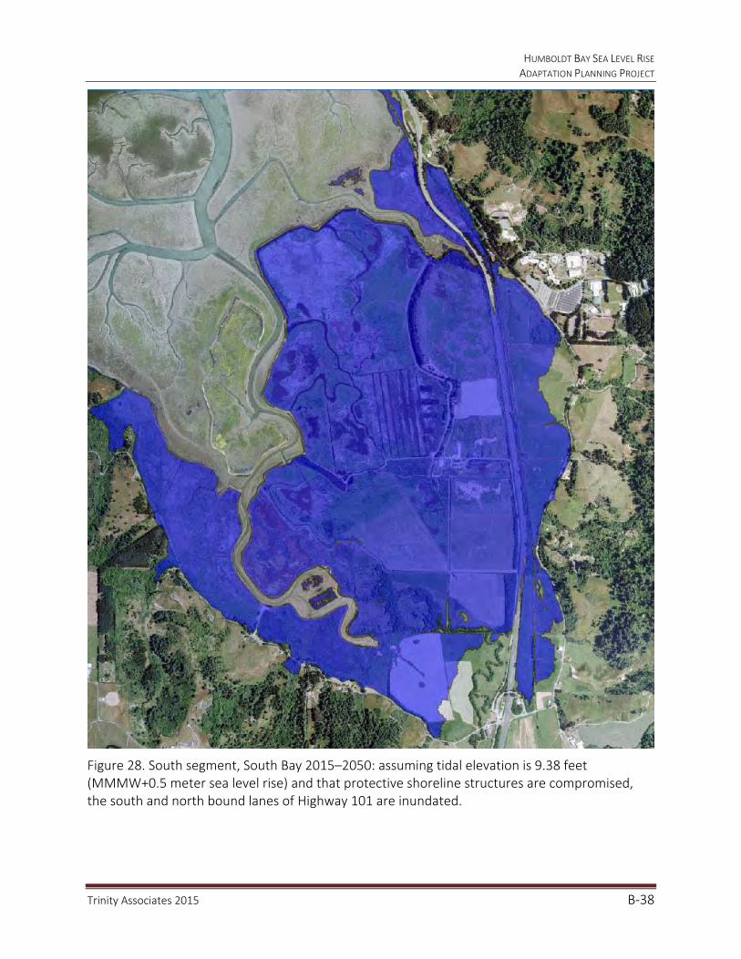
HUMBOLDT BAY SEA LEVEL RISE ADAPTATION PLANNING PROJECT
Trinity Associates 2015 B‐38
Figure 28. South segment, South Bay 2015–2050: assuming tidal elevation is 9.38 feet (MMMW+0.5 meter sea level rise) and that protective shoreline structures are compromised, the south and north bound lanes of Highway 101 are inundated.
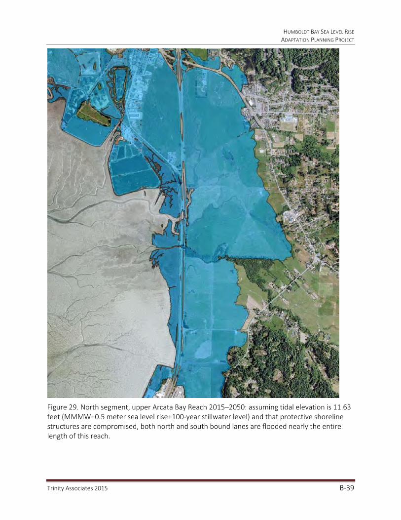
HUMBOLDT BAY SEA LEVEL RISE ADAPTATION PLANNING PROJECT
Trinity Associates 2015 B‐39
Figure 29. North segment, upper Arcata Bay Reach 2015–2050: assuming tidal elevation is 11.63 feet (MMMW+0.5 meter sea level rise+100‐year stillwater level) and that protective shoreline structures are compromised, both north and south bound lanes are flooded nearly the entire length of this reach.

HUMBOLDT BAY SEA LEVEL RISE ADAPTATION PLANNING PROJECT
Trinity Associates 2015 B‐40
Figure 30. Middle segment, south of Eureka 2015–2050: assuming the tidal elevation is 11.63 feet (MMMW+0.5 meter sea level rise+100‐year stillwater level) and that protective shoreline structures are compromised, the south and north bound lanes of Highway 101 are flooded.

HUMBOLDT BAY SEA LEVEL RISE ADAPTATION PLANNING PROJECT
Trinity Associates 2015 B‐41
c. 2050 to 2100: 1.0 meter of Sea Level Rise
One meter of sea level rise is projected for 2100 and combined with MMMW would rise to 11.02 feet. The elevation of MMMW plus 1.0 meter of sea level rise is lower than the elevation of the 100 year event with 0.5 meters of sea level rise (11.63 feet). Most areas that would be infrequently affected by the 100 year extreme event will become tidally inundated much more frequently by 2100 if the projected 1.0 meter of sea level rise occurs. Figures 29-30, illustrated inundation areas for the 100 year extreme event and 0.5 meter of sea level rise, which are very similar in areal extent to the 1.0 meter tidal inundation areas illustrated in Figures 31-32, the difference will be in the frequency and depth of inundation. Figures 33-34, illustrate that south and north bound lanes of Highway 101 in the north reach of Arcata Bay and the low-lying area south of Eureka that are tidally inundated with 1.0 meter of sea level rise and the 100 year extreme event (13.27 feet).
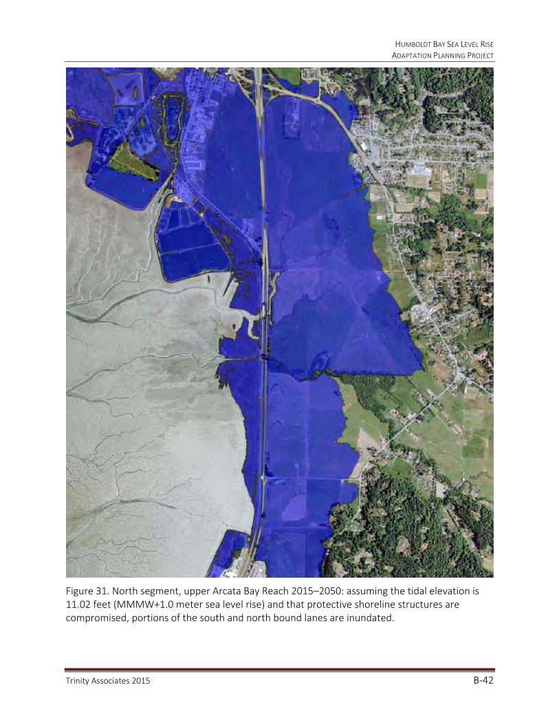
HUMBOLDT BAY SEA LEVEL RISE ADAPTATION PLANNING PROJECT
Trinity Associates 2015 B‐42
Figure 31. North segment, upper Arcata Bay Reach 2015–2050: assuming the tidal elevation is 11.02 feet (MMMW+1.0 meter sea level rise) and that protective shoreline structures are compromised, portions of the south and north bound lanes are inundated.
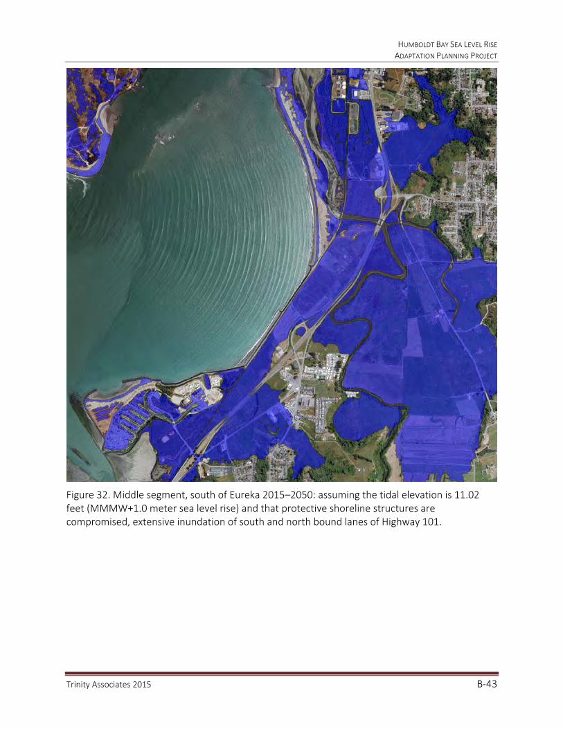
HUMBOLDT BAY SEA LEVEL RISE ADAPTATION PLANNING PROJECT
Trinity Associates 2015 B‐43
Figure 32. Middle segment, south of Eureka 2015–2050: assuming the tidal elevation is 11.02 feet (MMMW+1.0 meter sea level rise) and that protective shoreline structures are compromised, extensive inundation of south and north bound lanes of Highway 101.

HUMBOLDT BAY SEA LEVEL RISE ADAPTATION PLANNING PROJECT
Trinity Associates 2015 B‐44
Figure 33. North segment, upper Arcata Bay Reach 2050–2100: assuming the tidal elevation is 13.27 feet (MMMW+1.0 meter sea level rise+100‐year stillwater level) and that protective shoreline structures are compromised, both north and south bound lanes are almost entirely flooded.
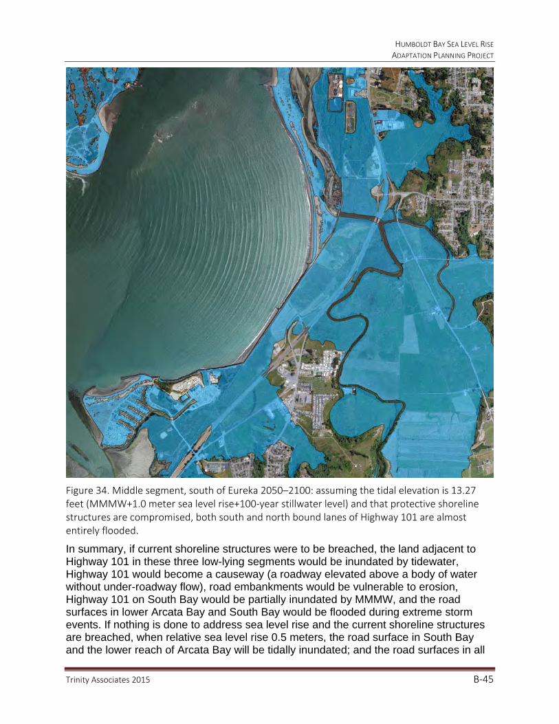
HUMBOLDT BAY SEA LEVEL RISE ADAPTATION PLANNING PROJECT
Trinity Associates 2015 B‐45
Figure 34. Middle segment, south of Eureka 2050–2100: assuming the tidal elevation is 13.27 feet (MMMW+1.0 meter sea level rise+100‐year stillwater level) and that protective shoreline structures are compromised, both south and north bound lanes of Highway 101 are almost entirely flooded.
In summary, if current shoreline structures were to be breached, the land adjacent to Highway 101 in these three low-lying segments would be inundated by tidewater, Highway 101 would become a causeway (a roadway elevated above a body of water without under-roadway flow), road embankments would be vulnerable to erosion, Highway 101 on South Bay would be partially inundated by MMMW, and the road surfaces in lower Arcata Bay and South Bay would be flooded during extreme storm events. If nothing is done to address sea level rise and the current shoreline structures are breached, when relative sea level rise 0.5 meters, the road surface in South Bay and the lower reach of Arcata Bay will be tidally inundated; and the road surfaces in all

HUMBOLDT BAY SEA LEVEL RISE ADAPTATION PLANNING PROJECT
Trinity Associates 2015 B‐46
three low-lying segments will be flooded during extreme events. With 1.0 meter of relative sea level rise, 57 percent of the dikes and 64 percent of the railroad grade will be overtopped and the road surface in the low-lying segment south of Eureka would be tidally inundated, as would the south bound and most of the north bound lane in the upper reach on Arcata Bay; similarly the diked shoreline will be overtopped and the upper segment on Arcata Bay will be totally inundated with 1.5 meters of relative sea level rise.
The Project’s Phase II produced GIS models and maps of the areal extent of inundation and flooding during extreme events. It will be possible, with this GIS dataset, for future projects to determine the depth of inundation or flooding at any location.
2. Sensitivity Assessment
Sensitivity assessment addresses the resiliency of the asset, its ability to accommodate or adjust to impacts and maintain its primary functions, and the adaptive capacity of the entity responsible for the maintenance and performance of the asset to address the impacts to the asset. Frequent tidal inundation of any of Highway 101 segments would likely not be tolerable, but temporary or nuisance inundation and flooding could result in temporary closures and re-routing. The adaptation strategies and options discussion below highlights the level of resiliency of each of the low-lying segments on Highway 101 to sea level rise over time. The adaptive capacity of Caltrans, who manages and maintains the Highway 101 corridor, is complicated by that fact that most of the highway does not form the shoreline on Humboldt Bay, the exception being a short reach along the north bound lanes just before Elk River Slough. The shorelines in the hydrologic sub-units that protect the low-lying segments of the highway from tidal inundation or flooding are owned by a mix of public and private entities. If Caltrans is not restricted from spending public funds on non-state assets or properties to protect its assets, it is possible that Caltrans could proactively partner with shoreline property owners as discussed below to protect Highway 101 through 2050. Ultimately, maintaining the services provided by Highway 101 through 2100 is within the adaptive capacity of Caltrans.
3. Significance Assessment
The magnitude of sea level rise impacts on the performance of Highway 101 will differ spatially and temporally in each of the low-lying segments at risk from sea level rise, as discussed below. Short-term interruption from tidal inundation or flooding of transportation service on any segment of Highway 101 will be inconvenient, but long-term disruption from frequent tidal inundation would be significant to the communities on Humboldt Bay and to California’s North Coast. There is little doubt that the transportation services that Highway 101 provides are critical to the continued sustainability of the communities on Humboldt Bay. There are no comparable alternative transportation options for the Humboldt Bay region.

HUMBOLDT BAY SEA LEVEL RISE ADAPTATION PLANNING PROJECT
Trinity Associates 2015 B‐47
ADAPTATION STRATEGIES
In general, adaptation strategies for transportation systems fall under several categorical approaches regarding sea level rise impacts to assets at risk: (1) no action or business as usual, (2) protect and defend, (3) accommodate, and (4) relocate or retreat. Each approach is discussed in more detail in the following sections.
Planning for Hydrologic Sub‐units
There are 6 hydrologic units on Humboldt Bay: Arcata, Eureka and South Bays, and Mad River, Eureka and Elk River Sloughs. These hydrologic units can be stratified into 27 hydrologically separate sub-units or flood cells. It is important to realize when developing adaptation options that the entire length of shoreline within a sub-unit that Highway 101 traverses is protecting the highway from inundation and flooding. Therefore, hydrologic sub-units must be addressed in their entirety in terms of timing of tidal inundation and flooding of the highway and when evaluating adaptation strategies and options. For example the shoreline of the Fay Slough sub-unit is protecting Highway 101 from tidal inundation. A breach in the shoreline anywhere along its length could initiate tidal flooding of the highway road prism (Figure 35).
Figure 35. Fay Slough sub‐unit shoreline protects Highway 101 from tidal inundation.
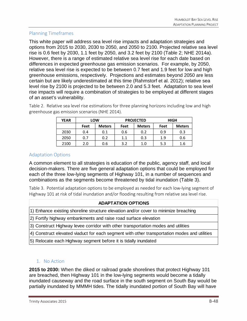
HUMBOLDT BAY SEA LEVEL RISE ADAPTATION PLANNING PROJECT
Trinity Associates 2015 B‐48
Planning Timeframes
This white paper will address sea level rise impacts and adaptation strategies and options from 2015 to 2030, 2030 to 2050, and 2050 to 2100. Projected relative sea level rise is 0.6 feet by 2030, 1.1 feet by 2050, and 3.2 feet by 2100 (Table 2; NHE 2014a). However, there is a range of estimated relative sea level rise for each date based on differences in expected greenhouse gas emission scenarios. For example, by 2050, relative sea level rise is expected to be between 0.7 feet and 1.9 feet for low and high greenhouse emissions, respectively. Projections and estimates beyond 2050 are less certain but are likely underestimated at this time (Rahmstorf et al. 2012); relative sea level rise by 2100 is projected to be between 2.0 and 5.3 feet. Adaptation to sea level rise impacts will require a combination of strategies to be employed at different stages of an asset’s vulnerability.
Table 2. Relative sea level rise estimations for three planning horizons including low and high greenhouse gas emission scenarios (NHE 2014).
Adaptation Options
A common element to all strategies is education of the public, agency staff, and local decision-makers. There are five general adaptation options that could be employed for each of the three low-lying segments of Highway 101, in a number of sequences and combinations as the segments become threatened by tidal inundation (Table 3).
Table 3. Potential adaptation options to be employed as needed for each low‐lying segment of Highway 101 at risk of tidal inundation and/or flooding resulting from relative sea level rise.
1. No Action
2015 to 2030: When the diked or railroad grade shorelines that protect Highway 101 are breached, then Highway 101 in the low-lying segments would become a tidally inundated causeway and the road surface in the south segment on South Bay would be partially inundated by MMMH tides. The tidally inundated portion of South Bay will have
YEAR LOW PROJECTED HIGH
Feet Meters Feet Meters Feet Meters
2030 0.4 0.1 0.6 0.2 0.9 0.3
2050 0.7 0.2 1.1 0.3 1.9 0.6
2100 2.0 0.6 3.2 1.0 5.3 1.6
ADAPTATION OPTIONS
1) Enhance existing shoreline structure elevation and/or cover to minimize breaching
2) Fortify highway embankments and raise road surface elevation
3) Construct Highway levee corridor with other transportation modes and utilities
4) Construct elevated viaduct for each segment with other transportation modes and utilities
5) Relocate each Highway segment before it is tidally inundated
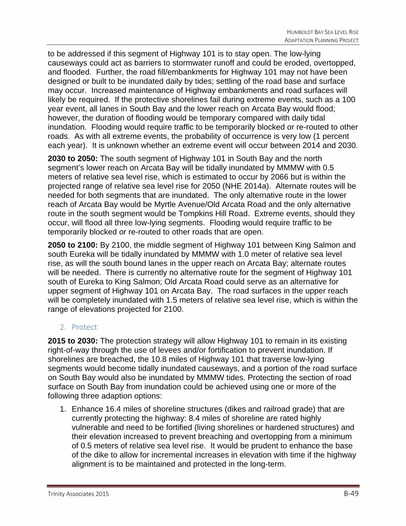
HUMBOLDT BAY SEA LEVEL RISE ADAPTATION PLANNING PROJECT
Trinity Associates 2015 B‐49
to be addressed if this segment of Highway 101 is to stay open. The low-lying causeways could act as barriers to stormwater runoff and could be eroded, overtopped, and flooded. Further, the road fill/embankments for Highway 101 may not have been designed or built to be inundated daily by tides; settling of the road base and surface may occur. Increased maintenance of Highway embankments and road surfaces will likely be required. If the protective shorelines fail during extreme events, such as a 100 year event, all lanes in South Bay and the lower reach on Arcata Bay would flood; however, the duration of flooding would be temporary compared with daily tidal inundation. Flooding would require traffic to be temporarily blocked or re-routed to other roads. As with all extreme events, the probability of occurrence is very low (1 percent each year). It is unknown whether an extreme event will occur between 2014 and 2030.
2030 to 2050: The south segment of Highway 101 in South Bay and the north segment’s lower reach on Arcata Bay will be tidally inundated by MMMW with 0.5 meters of relative sea level rise, which is estimated to occur by 2066 but is within the projected range of relative sea level rise for 2050 (NHE 2014a). Alternate routes will be needed for both segments that are inundated. The only alternative route in the lower reach of Arcata Bay would be Myrtle Avenue/Old Arcata Road and the only alternative route in the south segment would be Tompkins Hill Road. Extreme events, should they occur, will flood all three low-lying segments. Flooding would require traffic to be temporarily blocked or re-routed to other roads that are open.
2050 to 2100: By 2100, the middle segment of Highway 101 between King Salmon and south Eureka will be tidally inundated by MMMW with 1.0 meter of relative sea level rise, as will the south bound lanes in the upper reach on Arcata Bay; alternate routes will be needed. There is currently no alternative route for the segment of Highway 101 south of Eureka to King Salmon; Old Arcata Road could serve as an alternative for upper segment of Highway 101 on Arcata Bay. The road surfaces in the upper reach will be completely inundated with 1.5 meters of relative sea level rise, which is within the range of elevations projected for 2100.
2. Protect
2015 to 2030: The protection strategy will allow Highway 101 to remain in its existing right-of-way through the use of levees and/or fortification to prevent inundation. If shorelines are breached, the 10.8 miles of Highway 101 that traverse low-lying segments would become tidally inundated causeways, and a portion of the road surface on South Bay would also be inundated by MMMW tides. Protecting the section of road surface on South Bay from inundation could be achieved using one or more of the following three adaption options:
1. Enhance 16.4 miles of shoreline structures (dikes and railroad grade) that are currently protecting the highway: 8.4 miles of shoreline are rated highly vulnerable and need to be fortified (living shorelines or hardened structures) and their elevation increased to prevent breaching and overtopping from a minimum of 0.5 meters of relative sea level rise. It would be prudent to enhance the base of the dike to allow for incremental increases in elevation with time if the highway alignment is to be maintained and protected in the long-term.
HUMBOLDT BAY SEA LEVEL RISE ADAPTATION PLANNING PROJECT
Trinity Associates 2015 B‐50
2. The highway fill/embankment could be fortified (living shorelines or hardened structures) and raised; there are 21.6 miles (10.8 x 2) of embankment that would need to be fortified and raised to prevent erosion or road surface subsidence and tidal inundation, or flooding by wind waves and storm surges.
3. Construct 21.6 miles (10.8 x 2) of new dikes/levees parallel to the highway capable of preventing tidal inundation from a minimum of 1.0 meters of relative sea level rise to create a secure transportation corridor. It would be prudent to build the base of the dikes to allow for incremental increases in elevation with time if the Highway alignment is to be maintained and protected in the long-term and to accommodate living shoreline features.
Caltrans could work with multiple partners to enhance vulnerable shoreline segments to prevent tidal inundation of adjacent lands, utilities, and the roadway from relative sea level rise. Key partners include the Regional Transportation Authority-Humboldt County Association of Governments (HCAOG); property owners with protective shoreline structures like dikes, railroad grades and trails; and utilities such as PG&E, City of Eureka, and Humboldt Community Services District, who are also benefitting from these protective shoreline structures.
Average annual king tides (8.8 feet) are projected to be 0.5 feet higher (9.3 feet) by 2030; coupled with extreme events they would temporarily cause flooding of reaches of Highway 101 on South Bay and the lower reach on Arcata Bay, requiring traffic to be temporarily blocked or re-routed to local service roads.
2030 to 2050: It is projected that relative sea level rise will be 1.1 feet by 2050; the estimated range for 2050 is 0.7 feet to 1.9 feet (NHE 2014a). The Project inundation/flood modeling and mapping of MMMW with 0.5 meters relative sea level rise indicates that it will be necessary to protect 6.2 miles of road surface (3.5 miles on lower reach of Arcata Bay and 2.7 miles on South Bay) that would be tidally inundated. If the highway fill/embankment had been fortified (Option 2 for 2015–2030) but if the road surface elevation was not increased, then it would now be necessary in the lower reach of Arcata Bay (3.5 miles) and on South Bay (2.7 miles). Road surfaces in these two segments will need to be raised 1.0 to 2.0 meters to avoid tidal inundation through 2100. If existing protective shoreline structures had been enhanced (Option 1) or new protective dikes were constructed (Option 3), it may not be necessary to raise these road surfaces at this time.
Average annual king tides will also be 1.0 to 1.5 feet higher (9.8 to 10.3 feet) by 2050, and coupled with extreme events, they will temporarily cause flooding (if they occur), in all low-lying segments of Highway 101. Traffic will be temporarily blocked or need to be re-routed to local service roads.
2050 to 2100: relative sea level rise is projected to reach 3.2 feet by 2100 and the estimated range is 2.0 to 5.3 feet (NHE 2014a). Raising the highway road surface, if it has not already occurred, could be expanded to incrementally increase the height of the highway causeway on all 10.6 miles of low-lying segments by 1.0 to 2.0 meters.

HUMBOLDT BAY SEA LEVEL RISE ADAPTATION PLANNING PROJECT
Trinity Associates 2015 B‐51
If the first option has been employed, then the protective shoreline structures will need to be raised 1.0 to 1.5 meters higher than the 2015 shoreline elevation. However, raising existing shoreline structures to such an elevation may not be feasible for agricultural property owners, as rising groundwater will likely eliminate current land uses and compromise utilities located on these lands if they have not been relocated to areas that are more serviceable for ongoing maintenance. Also, living shoreline features such as salt marsh plains employed earlier may not be able to survive rising water levels of this magnitude without ongoing sediment augmentation, and as they drown they would no longer be able to protect vulnerable shorelines.
If option 3 has not yet occurred, then construction of 21.6 miles of new dikes parallel to the highway could create a secure transportation corridor through all 10.8 miles of low-lying segments on Humboldt Bay. Implementation of this option would be an opportunity to co-locate other critical assets such as gas and water lines, and other transportation routes (trail and rail), which could lead to the cost of adaptation being borne by multiple entities.
Protecting existing shorelines or constructing new shorelines and their ongoing maintenance, as discussed, will be a substantial and expensive undertaking. The useful life and cost of these protective adaptation options will need to be weighed in light of expected accelerated rate of relative sea level rise, and other adaptation options.
3. Accommodate
The benefit of this adaptation strategy, as with the protection strategy, is to continue to maintain the transportation corridor in its existing right-of-way.
2015 to 2030: If the existing shorelines are compromised, a viable adaptation strategy, either alone or in combination with any of the three protection options, would be to accommodate rising tides, extreme events, and stormwater runoff in low-lying segments of Highway 101 by way of a 4th option.
4. Increase drainage capacity by enlarging culverts, tide gates, and bridges, or constructing elevated viaducts over low-lying reaches. Ultimately, constructing an elevated viaduct in the three low-lying segments would eliminate the need for shoreline protection and would increase tidal exchange and drainage capacity to prevent overtopping and flooding of highway road surfaces. Under this adaptation option, the existing highway fill/embankment and road surfaces will likely need to be removed and the site restored to accommodate tidal flows. Accommodating relative sea level rise by constructing a viaduct will lead to tidal inundation of significant areas of former tidelands to the east of Highway 101, lands that Caltrans may not own and that are currently managed as agricultural lands.
During this time period, relative sea level rise is projected to reach 0.5 feet and average annual king tides could increase to 9.3 feet. To accommodate this level of relative sea level rise, tide gates could be removed to reduce backwater flooding inland, culverts could be replaced with bridges, and existing bridges could be lengthened to expand the capacity to convey tidal exchanges and stormwater runoff. Constructing elevated viaduct reaches is a more permanent means to accommodate rising sea levels in low-
HUMBOLDT BAY SEA LEVEL RISE ADAPTATION PLANNING PROJECT
Trinity Associates 2015 B‐52
lying areas than the protective measures described in the previous section. Accommodating relative sea level rise by constructing elevated viaducts to pass tidewater beneath the Highway structure will cause lands that Caltrans may not own to the east of Highway 101 to be inundated by tidewater.
2030 to 2050: With 1.0 foot or more of relative sea level rise by 2050, average king tides will reach 9.8 feet or higher. Consequently, shoreline breaching and/or overtopping may become frequent on Humboldt Bay, if options 1 through 3 have not been implemented. The 2.7 miles of Highway 101 on South Bay and on the 3.5 miles of the lower reach of Arcata Bay would be most at risk under these conditions. Building an elevated viaduct (the 4th option) would be required.
The elevation of a viaduct through the low-lying segments would be limited by the elevation of interconnecting highway segments. For the south segment on South Bay, the existing road surface elevation between the Tompkins Hill overpass and King Salmon may limit the elevation of the viaduct; for the middle segment between King Salmon and Eureka, the viaduct would be limited to the elevation of the highway in south Eureka; and the highway elevation at the north end of the City of Eureka would similarly limit the elevation of the viaduct on the lower reach of Arcata Bay in the north segment.
Average annual king tides will also be 1.0 to 1.5 feet higher (9.8 to 10.3 feet) than today by 2050, and coupled with extreme events, they will cause flooding in all low-lying segments of Highway 101; requiring traffic to be temporarily blocked or re-routed to local service roads.
2050 to 2100: relative sea level rise is projected to reach 3.2 feet by 2100 and the estimated range is 2.0 to 5.3 feet (NHE 2014a). Assuming that the highway reaches in South Bay and the lower reach of Arcata Bay have been protected or viaducts constructed, then the 2.3 miles in the middle segment between Eureka and King Salmon, and the 2.3 miles of the upper reach of Highway 101 on Arcata Bay will become inundated by 2100. Constructing elevated viaducts in these low-lying segments will be necessary to accommodate relative sea level rise.
4. Relocate
Ultimately, relative sea level rise will continue beyond 1.0 meters and 2100; it may not be feasible or sustainable to maintain Highway 101 in its present right-of-way traversing Humboldt Bay.
2015 to 2030: Based on relative sea level rise estimates, approximately 0.6 feet of relative sea level rise will occur in the study area before 2030. Extreme events could temporarily flood South Bay and the lower reach of Arcata Bay. It is unlikely that Caltrans would abandon the existing right-of-way at this time before considering employing previously discussed options 1 through 4. Relocation of a highway segment will involve securing a new right-of-way, building a new highway segment and the removal of the abandoned highway structures. It is unlikely that that relocation of the two most vulnerable segments or all of the low-lying segments is possible within this 16 year time period, given the lead time necessary for planning, permitting, right-of-way acquisitions, and construction.
HUMBOLDT BAY SEA LEVEL RISE ADAPTATION PLANNING PROJECT
Trinity Associates 2015 B‐53
2030 to 2050: With 1.0 to 2.0 feet of relative sea level possible by 2050, average king tides will reach 9.8 to 10.8 feet or higher. Consequently, shoreline breaching, overtopping, and tidal inundation of highway segments may become frequent on South Bay and the lower reach of Arcata Bay. A 5th option that could be considered is relocation of Highway 101.
5. Relocation could proceed in each low-lying segment independently or be combined in a region-wide relocation that would likely bypass the City of Eureka to the east.
Relocation of the South Bay highway segment to the Tompkins Hill Road right-of-way along the eastern margin of the Salmon Creek valley could be implemented from the Table Bluff grade north to the Tompkins Hill Road–Highway 101 on-ramp. Relocation of the highway in the lower reach of Arcata Bay could also occur along the Myrtle Avenue and Old Arcata Road right-of-way, but a new right-of-way would be required to join the highway at the upper reach of Arcata Bay at Bracut.
2050 to 2100: Relative sea level is projected to reach 3.2 feet by 2100 and the estimated range is 2.0 to 5.3 feet (NHE 2014a). If relocation of Highway 101 has not occurred in South Bay or the lower reach of Arcata Bay, then it would likely be considered for the entire length from Table Bluff to Arcata for this time frame and beyond 2100. Relocation and abandonment of the highway could proceed in phases or all at once. The environmental and social consequences and expense of relocating a major highway to the east of Humboldt Bay will be substantial.
CONCLUSIONS
Caltrans and the HCAOG (Regional Transportation Planning Agency), which includes the Cities of Eureka and Arcata, and Humboldt County, will be responsible for addressing sea level rise impacts to the regional transportation corridor of Highway 101 as it traverses Humboldt Bay. Prioritizing adaptation strategies and options will need to be a collaborative process between HCAOG and Caltrans. In addition, the Coastal Commission and the general public should be involved in any planning effort that will affect significant portions of Humboldt Bay and the future of the proposed Bay-wide trail system.
HUMBOLDT BAY SEA LEVEL RISE ADAPTATION PLANNING PROJECT
Trinity Associates 2015 B‐54
REFERENCES
California Natural Resources Agency. 2012. California Adaptation Planning Guide.
Laird, Aldaron, Brian Powell. 2013. Humboldt Bay shoreline inventory, mapping, and sea level rise vulnerability assessment, with an Addendum: Shoreline Vulnerability Ratings. Prepared for the State Coastal Conservancy.
Northern Hydrology and Engineering. 2014a. Estimates of local or relative sea level rise for Humboldt Bay region. Prepared for the California State Coastal Conservancy.
Northern Hydrology and Engineering. 2014b. Data release for the Humboldt Bay sea level rise vulnerability assessment: Humboldt Bay sea level rise inundation mapping. Prepared for the California State Coastal Conservancy.
Northern Hydrology and Engineering. 2014c. Humboldt Bay Sea Level Rise Hydrodynamic Modeling and Inundation Vulnerability Mapping. Prepared for the California State Coastal Conservancy.
Rahmstorf, Stefan, Grant Foster, and Anny Cazenave. 2012. Comparing Climate Projections to Observations up to 2011. Environmental Research Letters 7(4): 044035. doi:10.1088/1748-9326/7/4/044035.