Embed Size (px)
Citation preview
1
Hayle Town Framework Plan
(Background Evidence)
Review of Employment Sites
May 2010
2
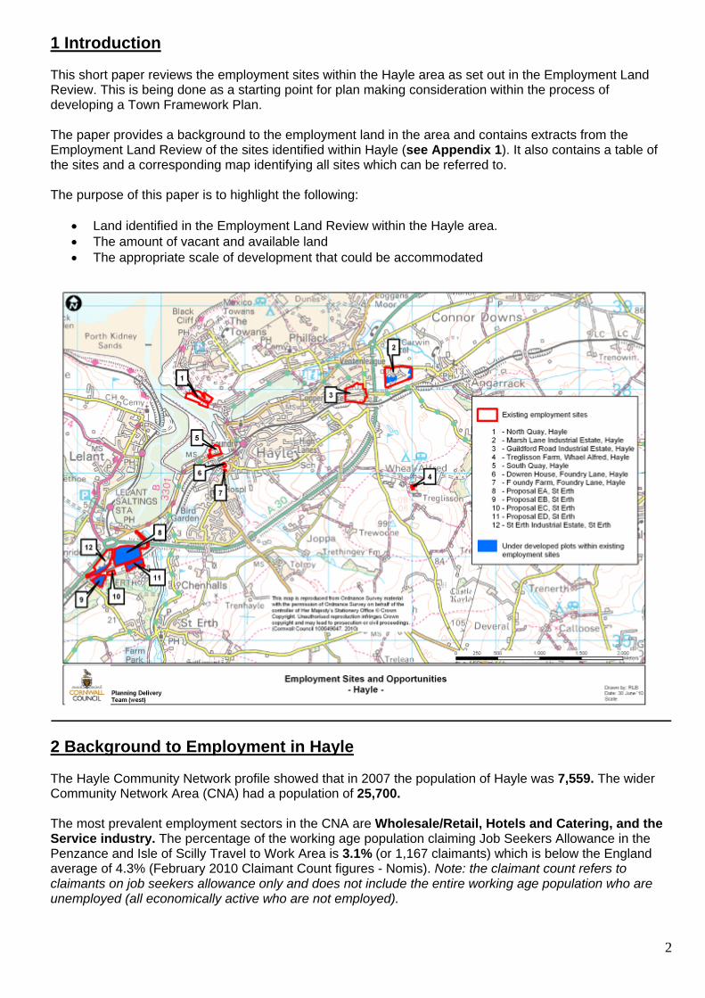
1 Introduction This short paper reviews the employment sites within the Hayle area as set out in the Employment Land Review. This is being done as a starting point for plan making consideration within the process of developing a Town Framework Plan. The paper provides a background to the employment land in the area and contains extracts from the Employment Land Review of the sites identified within Hayle (see Appendix 1). It also contains a table of the sites and a corresponding map identifying all sites which can be referred to. The purpose of this paper is to highlight the following:
• Land identified in the Employment Land Review within the Hayle area. • The amount of vacant and available land • The appropriate scale of development that could be accommodated
2 Background to Employment in Hayle The Hayle Community Network profile showed that in 2007 the population of Hayle was 7,559. The wider Community Network Area (CNA) had a population of 25,700. The most prevalent employment sectors in the CNA are Wholesale/Retail, Hotels and Catering, and the Service industry. The percentage of the working age population claiming Job Seekers Allowance in the Penzance and Isle of Scilly Travel to Work Area is 3.1% (or 1,167 claimants) which is below the England average of 4.3% (February 2010 Claimant Count figures - Nomis). Note: the claimant count refers to claimants on job seekers allowance only and does not include the entire working age population who are unemployed (all economically active who are not employed).
3
For the same period (October 2008 - September 2009) the number of people classified as employed was 77.3% (31,000) and the number classified as unemployed as 6.4% (2,000 people) (February 2010 Claimant Count figures - Nomis). In Hayle for the same period the number of people claiming job seekers allowance was 135 (6.75% of the TTWA’s total) compared with the total of 7,700 for the Cornwall Unitary Authority area (Dept for Works and Pensions: Work and Pensions Longitudinal Study, August 2009) The 2001 census showed that: 39.4% of the population of Hayle were in full time employment while a further 15.6% were engaged in part-time employment. 4.3% were classified as unemployed (estimate of people who are considered economically active but not employed). In December 2007 Amion Consulting produced an Employment Space Assessment for Cornwall County Council and the six district councils which included assessments for the former Penwith and Isles of Scilly Travel to Work Area (now superceded in name only by the Penzance and Isles of Scilly TTWA). This study covered the period 2007 to 2017 and used a number of growth scenarios. (2.8%, 3.2% and an aspirational scenario of 3.8%). The aspirational scenario was based on the assumption that by 2026 a GVA per capita target of 80% of the UK average will be reached for Cornwall and the Isles of Scilly, representing a growth rate of 3.7% pa. The study forecast for the Penzance and Isle of Scilly TTWA, that between 2007 and the end date of 2017 that employment related to: B1 a/b uses will grow by 707 jobs under the 2.8% scenario; 860 jobs under the 3.2% scenario and 1,030 jobs under the aspirational scenario. There is also expected to be an increase in B8 related employment under each growth scenario, with an increase in 61 jobs under the 2.8 scenario, 63 jobs under the 3.2% scenario and 231 under the aspirational scenario. B2/B1c related employment is projected to grow by 67 jobs under both the 2.8% and 3.2% scenarios but this is estimated to grow to 231 jobs under the aspirational 3.8% scenario. Overall the study demonstrated that the demand for employment space within the Penzance and Isles of Scilly TTWA is forecast to increase by: 19,921 sq m under the 2.8% scenario; 22,896 sq m under the 3.2% scenario and by 40,908 sq m under the aspirational scenario. The Amion study also forecast the net change in demand for employment land in the Penzance and Isles of Scilly TTWA from 2007 to 2017. Under each of the growth scenarios the demand for employment land is projected to grow, ranging from 3.1 ha for B2/B1c under the aspirational scenario to 1.5 ha under the 2.8% scenario. Demand for B1a/b and B8 employment is also expected to increase and overall demand is forecast to grow from between 5.4 ha and 1.3 ha respectively under the 2.8% scenario, and 7.8 ha and 5.0 ha respectively under the aspirational scenario (Source: ESSA technical Report; Table 4.8). Further analysis and details can be read in the full Amion study. - Table 1: Summary of Amion Study for Penwith and Isles of Scilly TTWA
Employment Growth - 2007-17 Floorspace Growth - 2007-17 (sqm) 2.8% 3.2% Aspirational (3.7%) 2.8% 3.2% Aspirational (3.7%) B1a/b 707 860 1.030 13,439 16,334 19,576B1c/B2 67 67 191 3,417 3,417 9,770B8 61 63 231 3,065 3,145 11,562TOTAL 835 990 1,452 19,921 22,896 40,908
Source: ESSA technical Report; Table 4.3 where job figures relating to floorspace is calculated using the ESSA assumptions of: 19 sq m per worker (B1a); 51 sq m per worker (B1c/B2); and 50 sq m per worker (B8). 3 Summary of Employment Sites Table 2 below sets out the sites identified in the Employment Land Review and sets out for each site:
• Size of the site • Size of developed vacant area (this includes vacant properties such as empty industrial units) • Size of undeveloped vacant area (this includes vacant land including buildings under construction) • Quality of the site (this is an average of the 6 different quality scores for each site)

4
• Accessibility by public transport (distance to railway station measured along most direct road/path, where convenient route could be identified)
• Accessibility to the main road network (distance to main A39) • Development constraints • Overall Employment Land Review score (out of a total of 60 points)
Table 2: Summary of Employment Land Review
Site Total area (ha)
Developed vacant area
Un-developed vacant area
Access to public transport
Access to the main road network
Average quality of the site
Development constraints
ELR Score (out of 60)
Dowren House, Foundry Lane, Hayle (High quality business park)
0.14 0 0 ELR score 5
28 48
Foundry Farm, Foundry Lane, Hayle (Incubator/SME cluster site)
0.025 19 sq m 0 ELR score 5
27 49
Guildford Road Industrial Estate, Guildford Road, Hayle (General industrial/business area)
4.628 0 0 ELR score 3
25 45
Marsh Lane Industrial Estate, Marsh Lane, Hayle (General industrial/business area)
6.167 0 1.402 ELR score 4
26 51
North Quay, North Quay, Hayle (General industrial/business area)
3.227 265 sq m 0 ELR score 5
17 WHS 38
South Quay, South Quay, Hayle (Warehouse/ distribution)
1.406 0 0 ELR score 5
18 WHS? 41
Treglisson Farm, Wheal Alfred, Hayle (General industrial/ business area)
0.176 0 0 ELR score 1
28 38
St Erth Industrial Estate, St Erth (General industrial/ business area)
3.735 0 1.067 ELR score 3 14 36
Proposal EA, St Erth (Allocated site)
6.3 0 6.3 ELR score 4 - 41
Proposal E-B, St Erth (Allocated site)
1.371 0 1.371 ELR score 3 - 37
Proposal E-C, St Erth (Allocated Site)
0.362 0 0 ELR score 3 - 39
Proposal E-D, St Erth (Allocated site)
1.465 0 1.465 ELR score 3 - 39
TOTALS
29.002
0
11.602
183 502
Note: The table does not include the main part of South Quay which comes under the Penwith Local Plan Proposal TV-D which provides for a mixed use development:

5
Hayle Harbour Proposals ING Red UK (Hayle Harbour) Ltd have an Outline application (08-0613) for the redevelopment of Hayle Harbour, currently deferred awaiting 106 agreement. The application proposes a mixed use development in line with Local Plan Proposal TV-D comprising a mix of residential (1,039 dwellings) with retail and business space including accommodation for the Wave Hub renewable energy project, 8,000 sq m of employment space on North Quay and a further 5,000 sq m of business space on South Quay and the adjacent land facing Harvey’s Foundry. The Penwith District Local Plan 2004 contained four allocations at St Erth near to Hayle, one of these, proposal E-C has been subsequently developed as a public amenity site for waste collection and recycling, the remaining three have been included in this assessment. The three allocations are located in a site contained to the west by the former St Erth Creamery, the St Ives Branch Line and St Erth River to the east and the A30 trunk road to the north. The sites were allocated at the time due to accessibility to the trunk road, potential for rail freight and the perception of supporting regeneration proposals at Hayle harbour. It should be noted that the last reason of supporting regeneration proposals at Hayle harbour is this report not clear. The proposals have not yet come forward for further development (apart from a section of proposal E-D which now houses a cake drying store associated with the adjacent water treatment works) mainly due to infrastructure requirements and issues surrounding accessibility. 4 Analysis Analysis of the Employment Land Review shows that there are 11 existing employment areas. The existing estate located at South Quay does not include the main part of South Quay which is alternatively covered by Penwith Local Plan Proposal TV-D) within and around Hayle. These 11 sites in total cover an area of 28.6 ha. In total there is 11.967 ha of undeveloped vacant land. The average overall score in the ELR for the sites (including the separate scores for the allocated areas) is 41 (against a Cornwall average from the ELR data of 36). The highest possible score (if every aspect was rated very good) would be 60. The sites have been classed as either good (score of >45), average (score 25-44) and poor (<25). Four sites in Hayle scored in the “good” category. All the other sites fell within the “average” category, with no sites being categorised as “poor”. The lowest score at 36 was for an allocated site at St Erth. From 1st April 2006 31st March 2009 a total of 5,245 sq m of net employment floorspace has been developed with Hayle. This includes a total 666 sq m of B1, 4,579sq m of B2 and 0 sq m of B8. In addition a further 7,269 sq m of floorspace has detailed planning permission or is currently under construction for employment use. There are no recorded losses to employment land in Hayle. As a result the net employment floorspace with planning permission or under construction is 7,269sq m. Table 3 below sets out the net completions and permission/ under construction totals for Hayle from 1/4/06 to 31/3/09. The statistics for the year 2009 to 2010 are currently being compiled and are not yet available. Table 3: Summary of Employment Completions/ Permissions and sites Under Construction from 1/4/06 to 31/3/09 (Net figures) Completions (sq m) Floorspace with pp/uc Loss of space NET TOTAL B1 666 - - 666 B2 4,579 5,849 - 10,428 B8 - 1,420 - 1,420 TOTAL 5245 7269 - 12,514 Permissions with UCO of B1,B2 and B8 are here counted as B2 It should be noted that these figures were compiled from data gathered by the former Penwith District Council as a part of the annual employment land monitoring work. The totals only include use classes B1 to B8 as complete figures for other use classes are not available. For the sites with planning permission and under construction it is not possible to provide a break down into use classes B1a, b & c, so only a more general B1 figure can be used.
6
5 Conclusions This initial assessment of the Employment Land Review demonstrates that there is 11.6 ha of vacant undeveloped land on the 11 sites that were surveyed. The average score for quality of the 8 sites (the 4 allocated sites are not developed and so cannot be scored for built environment) was 23 out of a possible 30. There were only one sites that scored less than half of the possible points. Part of South Quay was not surveyed as part of the ELR as the historic quay is covered by Penwith Local Plan Proposal TV-D. The Amion Study 2007 gave a variety of scenarios for employment space growth, but the broad conclusion was that there will be a small increase in the demand for B1c and B2 employment land of between 1.5ha to 4.2ha; an increase in the demand for B1a/b of between 5.4ha and 7.8ha; and B8 from between 1.3ha and 5ha of employment land from 2007 to 2017. These trends are borne out by analysis of the employment completions and sites with planning permission or under construction which demonstrates a similar growth to B1, B2 and B8 uses. The ELR, in focussing on existing sites and did not consider the potential for employment sites linked to new development proposal that may emerge as a strategy for Hayle is developed. Currently ING Red UK Ltd have submitted an Outline permission for a mixed use redevelopment of the harbour area which incorporates some 19.89ha of office and industrial space. A summary of the statistics demonstrates the following:
• Total vacant developed floorspace = 284 sq m • Net additional floorspace created (06-09) = 5,245sq m • Net floorspace with planning permission and under construction = 7,269sq m • Total vacant employment land = 11.6ha
7
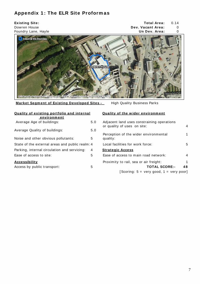
Appendix 1: The ELR Site Proformas Existing Site: Total Area: 0.14 Dowren House Dev. Vacant Area: 0 Foundry Lane, Hayle Un Dev. Area: 0
Market Segment of Existing Developed Sites - High Quality Business Parks Quality of existing portfolio and internal Quality of the wider environment environment Average Age of buildings: 5.0 Adjacent land uses constraining operations or quality of uses on site: 4 Average Quality of buildings: 5.0 Perception of the wider environmental 1 Noise and other obvious pollutants: 5 quality: State of the external areas and public realm: 4 Local facilities for work force: 5 Parking, internal circulation and servicing: 4 Strategic Access Ease of access to site: 5 Ease of access to main road network: 4 Accessibility Proximity to rail, sea or air freight: 1 Access by public transport: 5 TOTAL SCORE:- 48 [Scoring: 5 = very good, 1 = very poor]
8
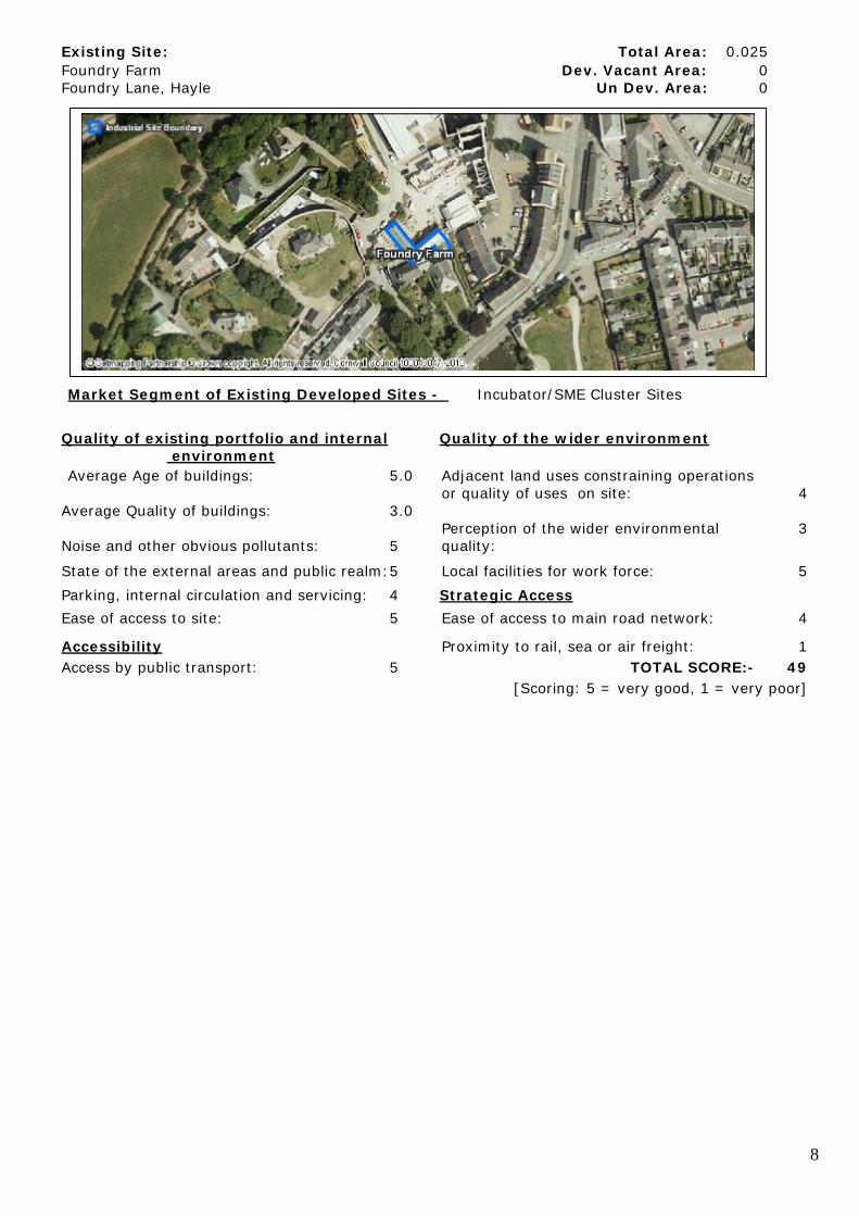
Existing Site: Total Area: 0.025 Foundry Farm Dev. Vacant Area: 0 Foundry Lane, Hayle Un Dev. Area: 0
Market Segment of Existing Developed Sites - Incubator/SME Cluster Sites Quality of existing portfolio and internal Quality of the wider environment environment Average Age of buildings: 5.0 Adjacent land uses constraining operations or quality of uses on site: 4 Average Quality of buildings: 3.0 Perception of the wider environmental 3 Noise and other obvious pollutants: 5 quality: State of the external areas and public realm: 5 Local facilities for work force: 5 Parking, internal circulation and servicing: 4 Strategic Access Ease of access to site: 5 Ease of access to main road network: 4 Accessibility Proximity to rail, sea or air freight: 1 Access by public transport: 5 TOTAL SCORE:- 49 [Scoring: 5 = very good, 1 = very poor]
9
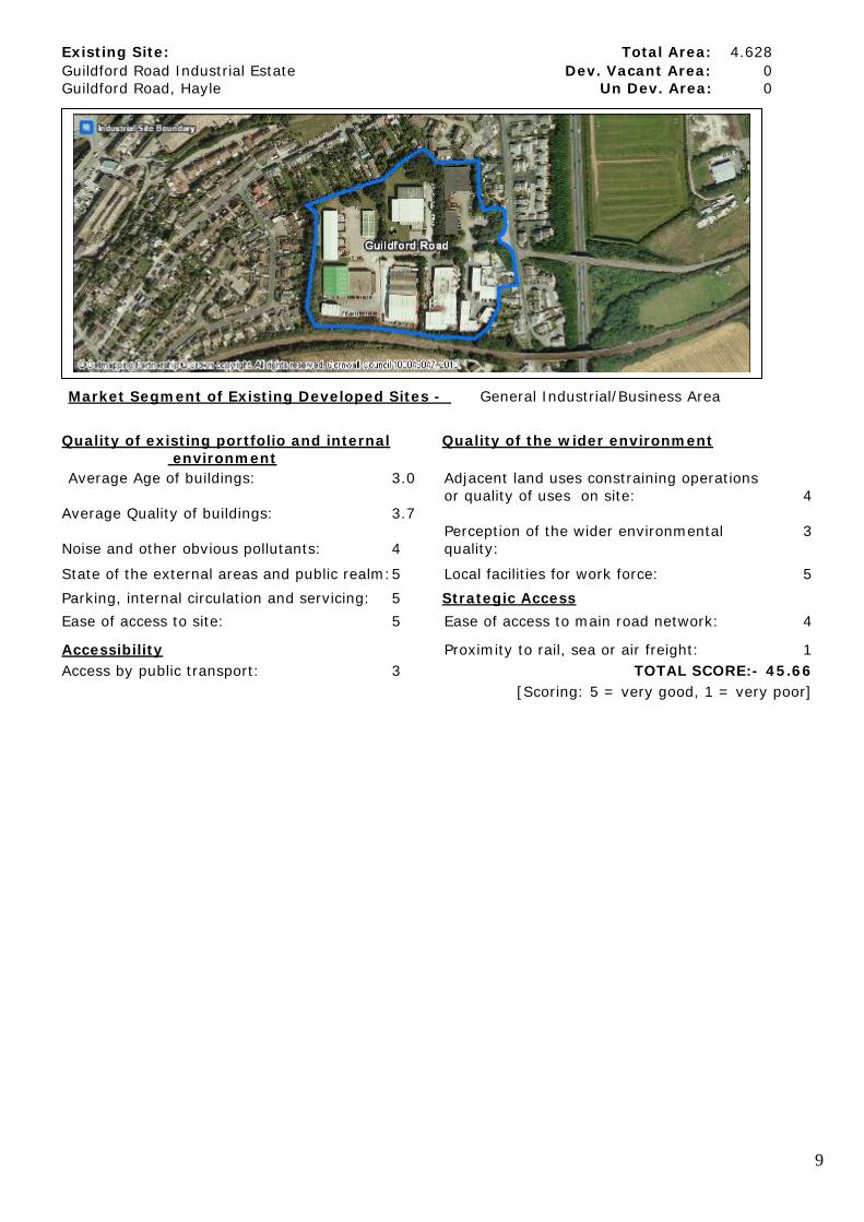
Existing Site: Total Area: 4.628 Guildford Road Industrial Estate Dev. Vacant Area: 0 Guildford Road, Hayle Un Dev. Area: 0
Market Segment of Existing Developed Sites - General Industrial/Business Area Quality of existing portfolio and internal Quality of the wider environment environment Average Age of buildings: 3.0 Adjacent land uses constraining operations or quality of uses on site: 4 Average Quality of buildings: 3.7 Perception of the wider environmental 3 Noise and other obvious pollutants: 4 quality: State of the external areas and public realm: 5 Local facilities for work force: 5 Parking, internal circulation and servicing: 5 Strategic Access Ease of access to site: 5 Ease of access to main road network: 4 Accessibility Proximity to rail, sea or air freight: 1 Access by public transport: 3 TOTAL SCORE:- 45.66 [Scoring: 5 = very good, 1 = very poor]

10
Existing Site: Total Area: 6.167 Marsh Lane Industrial Estate Dev. Vacant Area: 0 Marsh Lane, Hayle Un Dev. Area: 1.402
Market Segment of Existing Developed Sites - General Industrial/Business Area Quality of existing portfolio and internal Quality of the wider environment environment Average Age of buildings: 4.0 Adjacent land uses constraining operations or quality of uses on site: 5 Average Quality of buildings: 4.0 Perception of the wider environmental 5 Noise and other obvious pollutants: 4 quality: State of the external areas and public realm: 4 Local facilities for work force: 5 Parking, internal circulation and servicing: 5 Strategic Access Ease of access to site: 5 Ease of access to main road network: 5 Accessibility Proximity to rail, sea or air freight: 1 Access by public transport: 4 TOTAL SCORE:- 51 [Scoring: 5 = very good, 1 = very poor]

11
Existing Site: Total Area: 3.227 North Quay Dev. Vacant Area: 0 North Quay, Hayle Un Dev. Area: 0
Market Segment of Existing Developed Sites - General Industrial/Business Area Quality of existing portfolio and internal Quality of the wider environment environment Average Age of buildings: 2.0 Adjacent land uses constraining operations or quality of uses on site: 5 Average Quality of buildings: 2.0 Perception of the wider environmental 2 Noise and other obvious pollutants: 4 quality: State of the external areas and public realm: 1 Local facilities for work force: 5 Parking, internal circulation and servicing: 5 Strategic Access Ease of access to site: 3 Ease of access to main road network: 3 Accessibility Proximity to rail, sea or air freight: 1 Access by public transport: 5 TOTAL SCORE:- 38 [Scoring: 5 = very good, 1 = very poor]

12
Existing Site: Total Area: 1.406 South Quay Dev. Vacant Area: 0 South Quay, Hayle Un Dev. Area: 0
Market Segment of Existing Developed Sites - Warehouse/Distribution Quality of existing portfolio and internal Quality of the wider environment environment Average Age of buildings: 2.0 Adjacent land uses constraining operations or quality of uses on site: 4 Average Quality of buildings: 2.0 Perception of the wider environmental 4 Noise and other obvious pollutants: 3 quality: State of the external areas and public realm: 2 Local facilities for work force: 5 Parking, internal circulation and servicing: 5 Strategic Access Ease of access to site: 4 Ease of access to main road network: 4 Accessibility Proximity to rail, sea or air freight: 1 Access by public transport: 5 TOTAL SCORE:- 41 [Scoring: 5 = very good, 1 = very poor]

13
Existing Site: Total Area: 0.176 Treglisson Farm Dev. Vacant Area: 0 Wheal Alfred, Hayle Un Dev. Area: 0
Market Segment of Existing Developed Sites - General Industrial/Business Area Quality of existing portfolio and internal Quality of the wider environment environment Average Age of buildings: 4.0 Adjacent land uses constraining operations or quality of uses on site: 5 Average Quality of buildings: 4.0 Perception of the wider environmental 1 Noise and other obvious pollutants: 5 quality: State of the external areas and public realm: 5 Local facilities for work force: 1 Parking, internal circulation and servicing: 5 Strategic Access Ease of access to site: 5 Ease of access to main road network: 1 Accessibility Proximity to rail, sea or air freight: 1 Access by public transport: 1 TOTAL SCORE:- 38 [Scoring: 5 = very good, 1 = very poor]
14
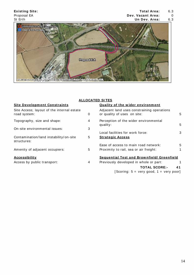
Existing Site: Total Area: 6.3 Proposal EA Dev. Vacant Area: 0 St Erth Un Dev. Area: 6.3
ALLOCATED SITES Site Development Constraints Quality of the wider environment Site Access; layout of the internal estate Adjacent land uses constraining operations road system: 0 or quality of uses on site: 5 Topography, size and shape: 4 Perception of the wider environmental quality: 5 On-site environmental issues: 3 Local facilities for work force: 3 Contamination/land instability/on-site 5 Strategic Access structures: Ease of access to main road network: 5 Amenity of adjacent occupiers: 5 Proximity to rail, sea or air freight: 1
Accessibility Sequential Test and Brownfield/Greenfield Access by public transport: 4 Previously developed in whole or part: 1 TOTAL SCORE:- 41 [Scoring: 5 = very good, 1 = very poor]

15
Existing Site: Total Area: 1.371 Proposal E-B Dev. Vacant Area: 0 St Erth Un Dev. Area: 1.371
ALLOCATED SITES Site Development Constraints Quality of the wider environment Site Access; layout of the internal estate Adjacent land uses constraining operations road system: 0 or quality of uses on site: 4 Topography, size and shape: 5 Perception of the wider environmental quality: 2 On-site environmental issues: 5 Local facilities for work force: 2 Contamination/land instability/on-site 5 Strategic Access structures: Ease of access to main road network: 4 Amenity of adjacent occupiers: 5 Proximity to rail, sea or air freight: 1
Accessibility Sequential Test and Brownfield/Greenfield Access by public transport: 3 Previously developed in whole or part: 1 TOTAL SCORE:- 37 [Scoring: 5 = very good, 1 = very poor]

16
Existing Site: Total Area: 0.362 Proposal E-C Dev. Vacant Area: 0 St Erth Un Dev. Area: 0
Quality of existing portfolio and internal Quality of the wider environment environment Average Age of buildings: 4.0 Adjacent land uses constraining operations or quality of uses on site: 4 Average Quality of buildings: 4.0 Perception of the wider environmental 3 Noise and other obvious pollutants: 2 quality: State of the external areas and public realm: 3 Local facilities for work force: 2 Parking, internal circulation and servicing: 5 Strategic Access Ease of access to site: 4 Ease of access to main road network: 4 Accessibility Proximity to rail, sea or air freight: 1 Access by public transport: 3 TOTAL SCORE:- 39 [Scoring: 5 = very good, 1 = very poor]
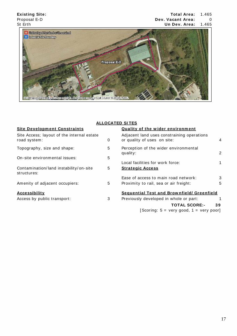
17
Existing Site: Total Area: 1.465 Proposal E-D Dev. Vacant Area: 0 St Erth Un Dev. Area: 1.465
ALLOCATED SITES Site Development Constraints Quality of the wider environment Site Access; layout of the internal estate Adjacent land uses constraining operations road system: 0 or quality of uses on site: 4 Topography, size and shape: 5 Perception of the wider environmental quality: 2 On-site environmental issues: 5 Local facilities for work force: 1 Contamination/land instability/on-site 5 Strategic Access structures: Ease of access to main road network: 3 Amenity of adjacent occupiers: 5 Proximity to rail, sea or air freight: 5
Accessibility Sequential Test and Brownfield/Greenfield Access by public transport: 3 Previously developed in whole or part: 1 TOTAL SCORE:- 39 [Scoring: 5 = very good, 1 = very poor]

18
Existing Site: Total Area: 3.735 St Erth Industrial Estate Dev. Vacant Area: 0 St Erth Un Dev. Area: 1.067
Market Segment of Existing Developed Sites - General Industrial/Business Area Quality of existing portfolio and internal Quality of the wider environment environment Average Age of buildings: 2.5 Adjacent land uses constraining operations or quality of uses on site: 4 Average Quality of buildings: 3.5 Perception of the wider environmental 5 Noise and other obvious pollutants: 2 quality: State of the external areas and public realm: 2 Local facilities for work force: 3 Parking, internal circulation and servicing: 4 Strategic Access Ease of access to site: 1 Ease of access to main road network: 5 Accessibility Proximity to rail, sea or air freight: 1 Access by public transport: 3 TOTAL SCORE:- 36 [Scoring: 5 = very good, 1 = very poor]

19