Embed Size (px)
Citation preview
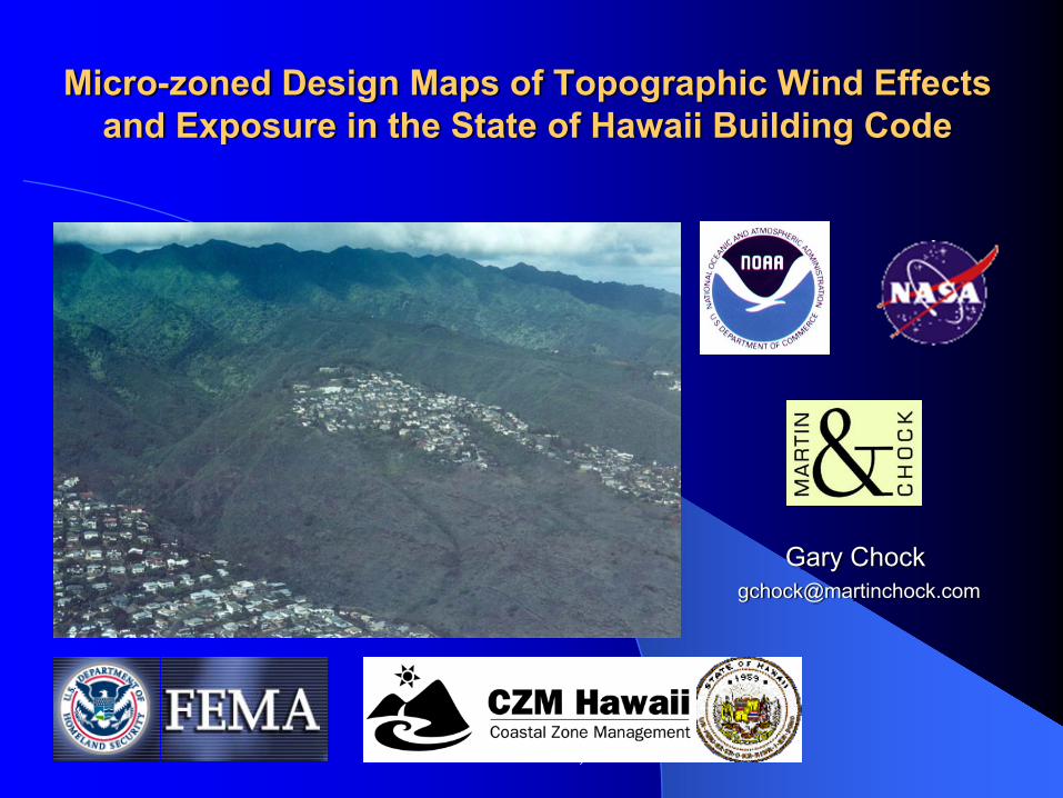
Micro-zoned Design Maps of Topographic Wind Effects and Exposure in the State of Hawaii Building Code
Gary Chock [email protected]
Martin & Chock, Inc.
Reasons for Customized Hawaii Wind Amendments to the International Building Code
Terrain-related amplification of wind speeds have been significant factors in losses from past hurricanes impacting Hawaii. The International Building Code references the ASCE-7 topographic factor, Kzt, and a directionality factor, Kd. – However, the topography in Hawaii is far more complex than envisioned
in the ASCE-7 standard provisions, that methodology was found to yield incorrect results in a 2001 Applied Research Associates study commissioned by the Hawaii Hurricane Relief Fund and a 2001 CPP/Martin & Chock study sponsored by the NASA Office of Earth Science.
As the IBC is adopted in Hawaii, structural engineers and architects needed an explicit procedure by which to determine design wind pressures in Hawaii that include topographic wind speed-up.
Martin & Chock, Inc.
Development of Topographic Wind Speed-up Methods for Hawaii
From 2000 to 2002, the NASA Office of Earth Science sponsored two initial projects under principal investigators Gary Chock and Jon Peterka that produced new methodologies pertaining to hurricane wind speeds and topographic effects. Subsequent development for code application have been sponsored by FEMA, NOAA, and the State of Hawaii.To determine speedup factors for Oahu and Kauai, terrain models of portions of the island terrain were constructed and tested in the wind tunnel. Wind speedups or reductions were measured at several hundred locations. Martin & Chock then constructed a phenomenological model to fit the measured data, and used that model to predict the wind speedup in all areas of Oahu, Kauai, Lanai, and Molokai.For the islands of Hawaii and Maui, Computational Fluid Dynamics are used via a Mesoscale Model [Peterka, 2007], with wind-tunnel tests of selected portions of the islands.
Martin & Chock, Inc.
Differences between Content in the Standard and Local Codes, per ASCE and NCSEA
“Material that is left in the building codeconforms to one of the following criteria:
Relates to local climatic, terrain, or other environmentalconditions, which many building officials will wish to specify whenadopting the model code by local ordinance. This includesspecification of basic wind speeds, terrain, exposure and similarprovisions.
Relates to enforcement of types of construction which is oftenset by condition so local practice, materials availability andconstruction industry capabilities
Is not presently covered in an adequate manner by a nationalconsensus standard. This includes to material covering roofingmaterials, hurricane protection of openings, etc.”
February, 2005Jim Rossberg, Structural Engineering Institute of ASCE, representing NCSEA Code Advisory Committee and
ASCE/SEI Martin & Chock, Inc.

The ASCE – 7-10 standard will formally designate Hawaii as a Special Wind Region where the
authorities having jurisdiction (State and Counties) shall establish the effects of topography on the
basic wind speed.C6.5.4.1 Special Wind Regions. Although the wind speed map
of Fig. 6-1 is valid for most regions of the country, there are special regions in which wind speed anomalies are known to exist. Some of these special regions are noted in Fig. 6-1. Winds blowing over mountain ranges or through gorges or river valleys in these special regions can develop speeds that are substantially higher than the values indicated on the map. When selecting basic wind speeds in these special regions, use of regional climatic data and consultation with a wind engineer or meteorologist is advised.
Martin & Chock, Inc.
Hawaii Special Wind Region
C6.5.4.1It is also possible that anomalies in wind speeds exist on a micrometeorological scale. For example, wind speed-up over hills and escarpments is addressed in Section 6.5.7. Wind speeds over complex terrain may be better determined by wind-tunnel studies as described in Section 6.6. Adjustments of wind speeds should be made at the micrometeorological scale on the basis of wind engineering or meteorological advice and used in accordance with the provisions of Section 6.5.4.2 when such adjustments are warranted. Due to the complexity of mountainous terrain and valley gorges in Hawaii, there are topographic wind speed-up effects that cannot be addressed solely by Figure 6-4. In the Hawaii Special Wind Region, there are special Kzt topographic effect adjustments to the Basic Wind Speed established by the authorities having jurisdiction.
Martin & Chock, Inc.
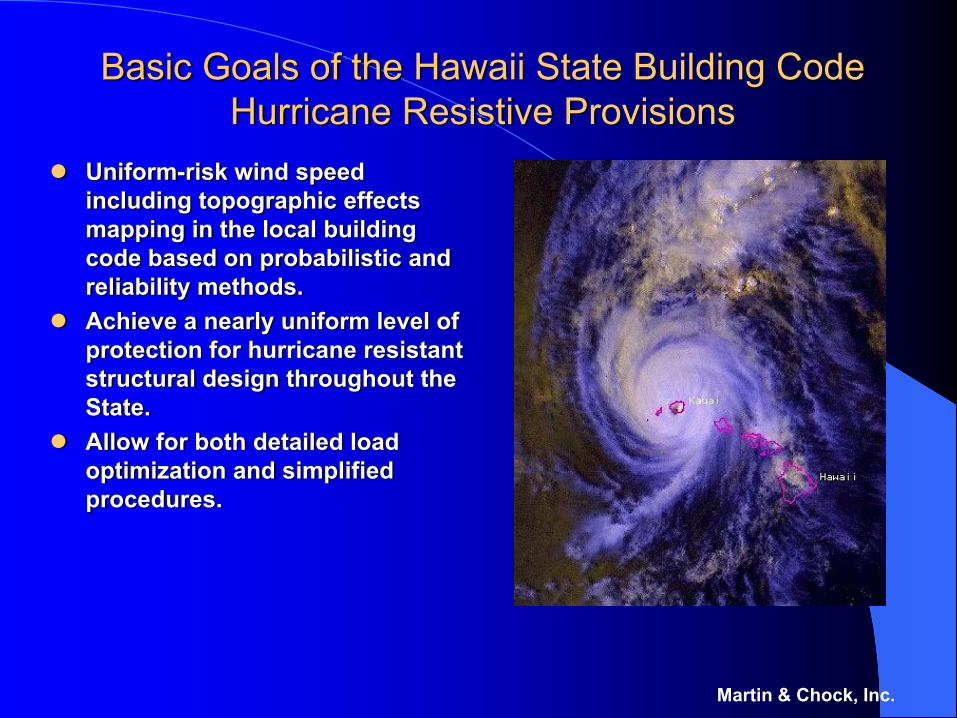
Basic Goals of the Hawaii State Building Code Hurricane Resistive Provisions
Uniform-risk wind speed including topographic effects mapping in the local building code based on probabilistic and reliability methods. Achieve a nearly uniform level of protection for hurricane resistant structural design throughout the State.Allow for both detailed load optimization and simplified procedures.
Martin & Chock, Inc.
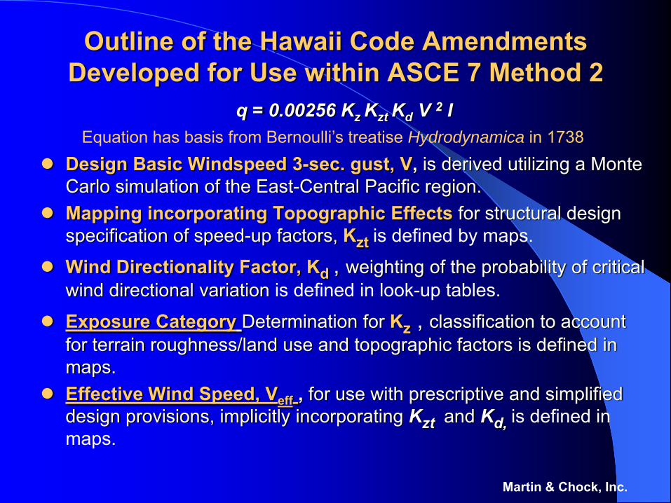
Outline of the Hawaii Code Amendments Developed for Use within ASCE 7 Method 2
q = 0.00256 Kz Kzt Kd V 2 I
Design Basic Windspeed 3-sec. gust, V, is derived utilizing a Monte Carlo simulation of the East-Central Pacific region.Mapping incorporating Topographic Effects for structural design specification of speed-up factors, Kzt is defined by maps.
Wind Directionality Factor, Kd , weighting of the probability of critical wind directional variation is defined in look-up tables.
Exposure Category Determination for Kz , classification to account for terrain roughness/land use and topographic factors is defined in maps.Effective Wind Speed, Veff , for use with prescriptive and simplified design provisions, implicitly incorporating Kzt and Kd, is defined in maps.
Martin & Chock, Inc.
Equation has basis from Bernoulli’s treatise Hydrodynamica in 1738
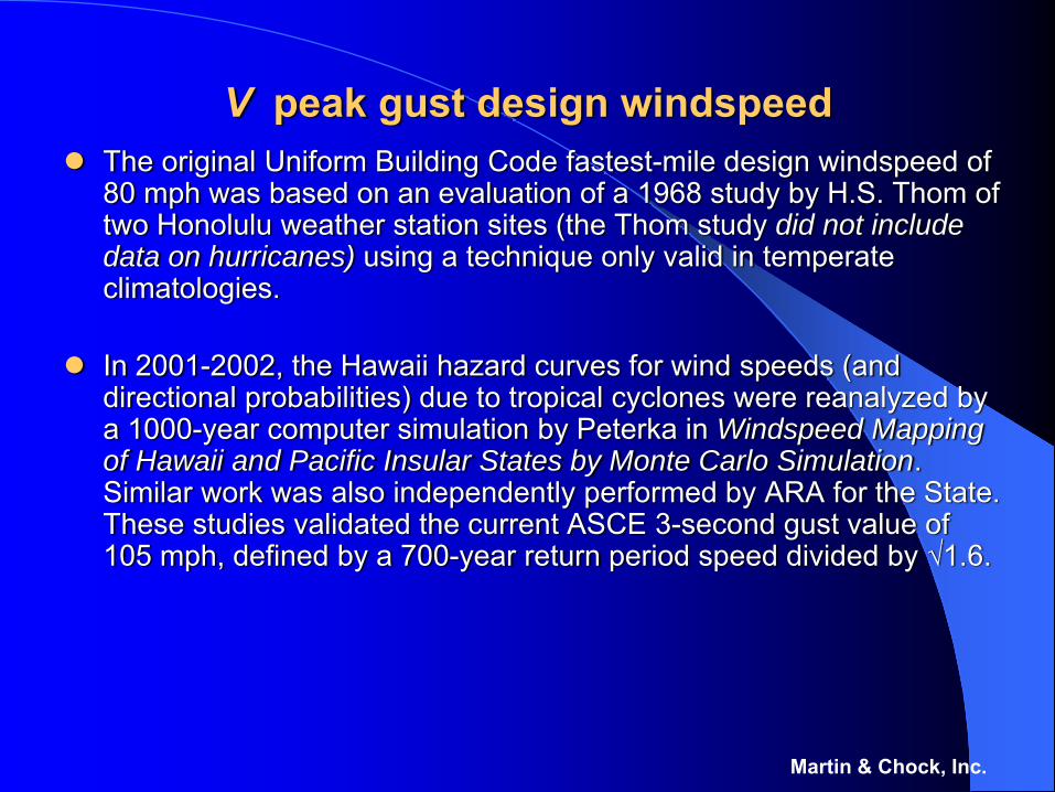
V peak gust design windspeedThe original Uniform Building Code fastest-mile design windspeed of 80 mph was based on an evaluation of a 1968 study by H.S. Thom of two Honolulu weather station sites (the Thom study did not include data on hurricanes) using a technique only valid in temperate climatologies.
In 2001-2002, the Hawaii hazard curves for wind speeds (and directional probabilities) due to tropical cyclones were reanalyzed by a 1000-year computer simulation by Peterka in Windspeed Mapping of Hawaii and Pacific Insular States by Monte Carlo Simulation. Similar work was also independently performed by ARA for the State. These studies validated the current ASCE 3-second gust value of 105 mph, defined by a 700-year return period speed divided by √1.6.
Martin & Chock, Inc.
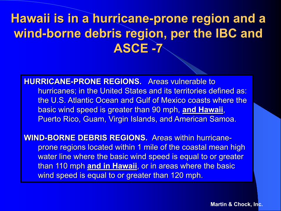
Hawaii is in a hurricane-prone region and a wind-borne debris region, per the IBC and
ASCE -7
Martin & Chock, Inc.
HURRICANE-PRONE REGIONS. Areas vulnerable to hurricanes; in the United States and its territories defined as: the U.S. Atlantic Ocean and Gulf of Mexico coasts where the basic wind speed is greater than 90 mph, and Hawaii, Puerto Rico, Guam, Virgin Islands, and American Samoa.
WIND-BORNE DEBRIS REGIONS. Areas within hurricane-prone regions located within 1 mile of the coastal mean high water line where the basic wind speed is equal to or greater than 110 mph and in Hawaii, or in areas where the basic wind speed is equal to or greater than 120 mph.
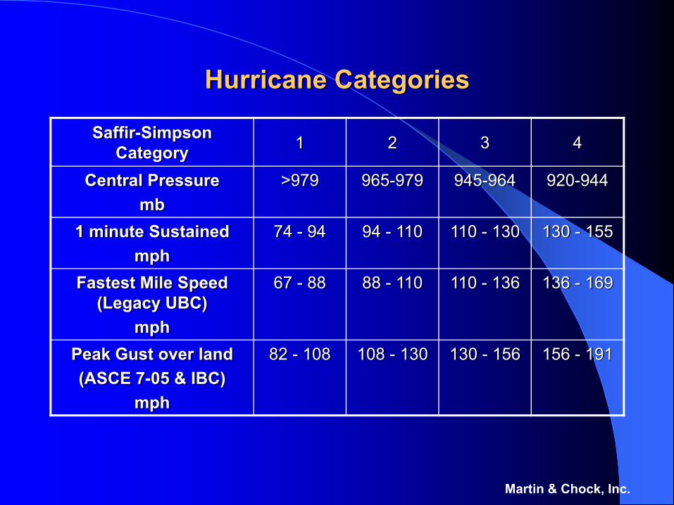
Hurricane Categories
Saffir-Simpson Category 1 2 3 4
Central Pressuremb
>979 965-979 945-964 920-944
1 minute Sustainedmph
74 - 94 94 - 110 110 - 130 130 - 155
Fastest Mile Speed (Legacy UBC)
mph
67 - 88 88 - 110 110 - 136 136 - 169
Peak Gust over land(ASCE 7-05 & IBC)
mph
82 - 108 108 - 130 130 - 156 156 - 191
Martin & Chock, Inc.
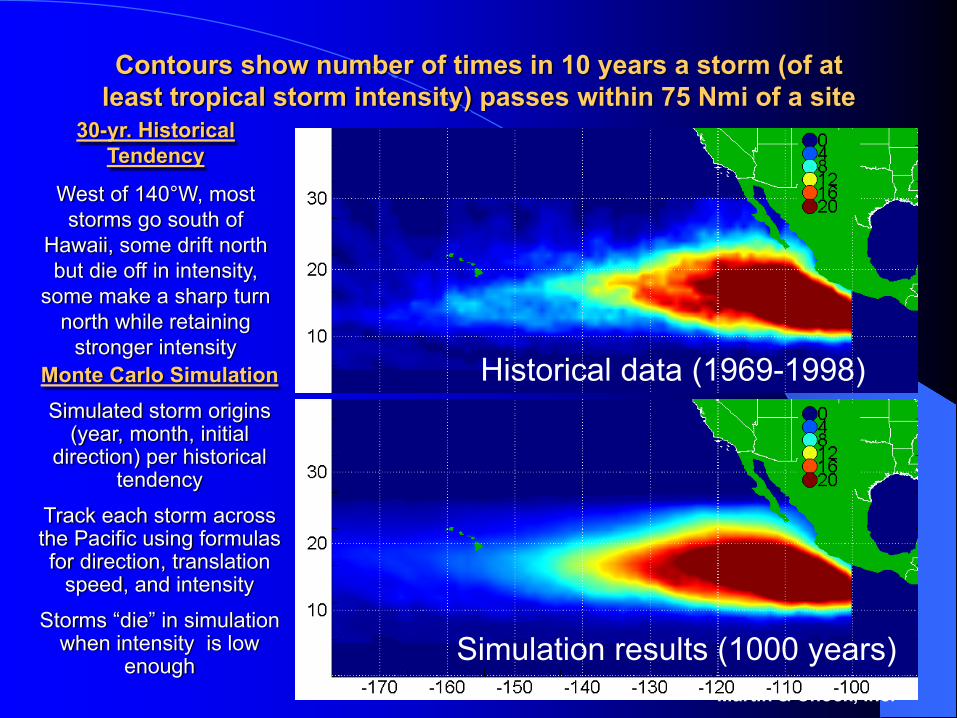
Contours show number of times in 10 years a storm (of at least tropical storm intensity) passes within 75 Nmi of a site
Martin & Chock, Inc.
Historical data (1969-1998)
Simulation results (1000 years)
30-yr. Historical Tendency
West of 140°W, most storms go south of
Hawaii, some drift north but die off in intensity,
some make a sharp turn north while retaining
stronger intensityMonte Carlo SimulationSimulated storm origins
(year, month, initial direction) per historical
tendency
Track each storm across the Pacific using formulas for direction, translation
speed, and intensity
Storms “die” in simulation when intensity is low
enough
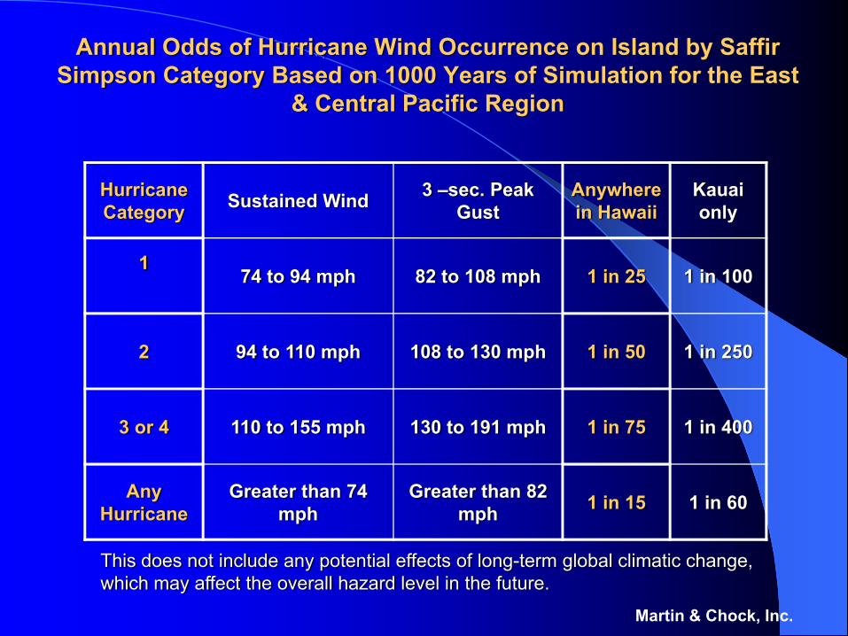
Annual Odds of Hurricane Wind Occurrence on Island by Saffir Simpson Category Based on 1000 Years of Simulation for the East
& Central Pacific Region
Martin & Chock, Inc.
Hurricane Category Sustained Wind 3 –sec. Peak
Gust Anywhere in Hawaii
Kauai only
174 to 94 mph 82 to 108 mph 1 in 25 1 in 100
2 94 to 110 mph 108 to 130 mph 1 in 50 1 in 250
3 or 4 110 to 155 mph 130 to 191 mph 1 in 75 1 in 400
Any Hurricane
Greater than 74 mph
Greater than 82mph 1 in 15 1 in 60
This does not include any potential effects of long-term global climatic change, which may affect the overall hazard level in the future.
67
86
113
129
143
174
05
101520253035404550556065707580859095
100105110115120125130135140145150155160165170175180185
10 100 1000 10000
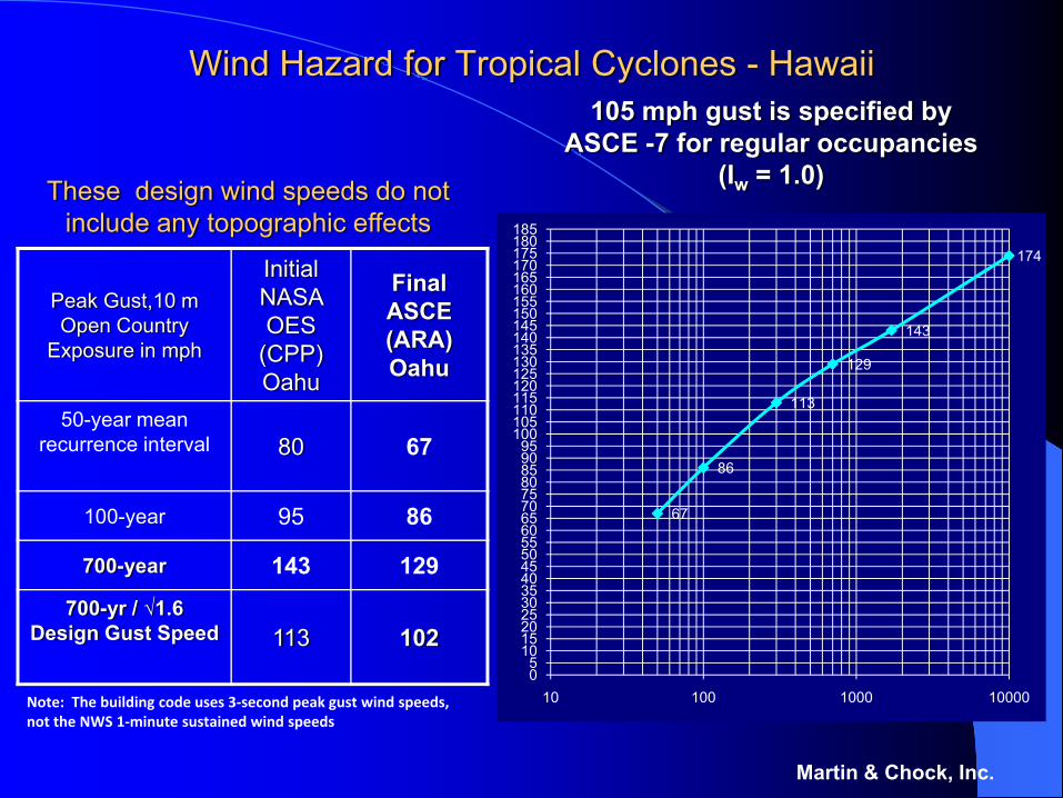
Wind Hazard for Tropical Cyclones - Hawaii
Peak Gust,10 mOpen Country
Exposure in mph
Initial NASA OES
(CPP)Oahu
Final ASCE (ARA) Oahu
50-year mean recurrence interval 80 67
100-year 95 86
700-year 143 129
700-yr / √1.6Design Gust Speed 113 102
Martin & Chock, Inc.
105 mph gust is specified by ASCE -7 for regular occupancies
(Iw = 1.0)These design wind speeds do not include any topographic effects
Note: The building code uses 3‐second peak gust wind speeds, not the NWS 1‐minute sustained wind speeds
Topographic Effects1609.3 Basic Wind Speed and Topographic and DirectionalityFactors. The basic wind speed, in mph, for the determination of the wind
loads shall be determined by Figure 1609. Special wind regions near mountainous terrain and valleys are accounted within the Topographic Factor defined in Section 1609.3.3. Wind speeds derived from simulation techniques shall only be used in lieu of the basic wind speeds given Figure 1609 when, (1) approved simulation or extreme-value statistical-analysis procedures are used (the use of regional wind speed data obtained from anemometers is not permitted to define the hurricane wind speed risk in Hawaii) and (2) the design wind speeds resulting from the study shall not be less than the resulting 700-year return period wind speed divided by √1.6.
Martin & Chock, Inc.
Special wind regions near mountainous terrain and valleys are accounted within the Topographic
Factor , Directionality Factor, and Effective Wind Speeds that are defined within IBC Section 1609
amendments.Honolulu Wind Maps were incorporated as code amendments to the 2003 IBC and became effective September 18, 2007. Electronic map pdfs with higher resolution published on the County DPP websiteCounty of Hawaii Wind Maps and code amendment text to the IBC 2006 were completed May, 2007. Electronic map pdfs with higher resolution have been prepared.County of Maui Wind Mapping was completed Spring 2008County of Kauai Wind Mapping were completed in October 2008The Hawaii State Building Code adopting these maps will become effective for State construction during 2009 with the 2006 IBC. The counties (besides Oahu) will be required to adopt the Hawaii State Building Code by 2010.
Martin & Chock, Inc.
Martin & Chock, Inc.
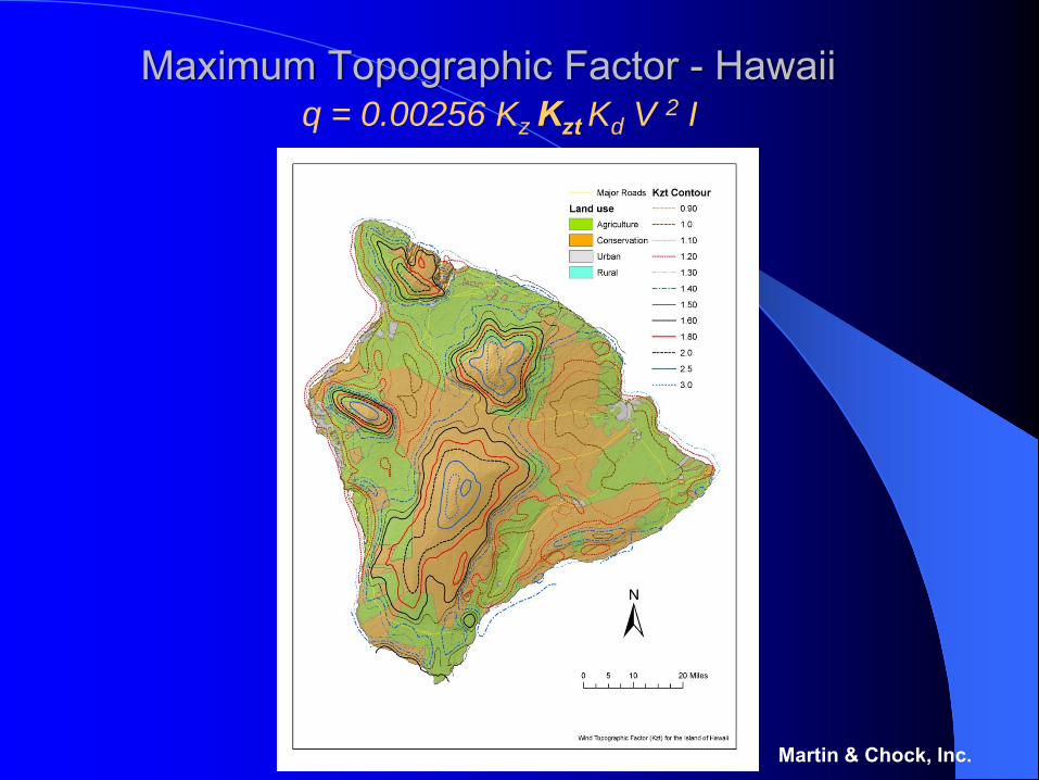
Maximum Topographic Factor - Hawaiiq = 0.00256 Kz Kzt Kd V 2 I
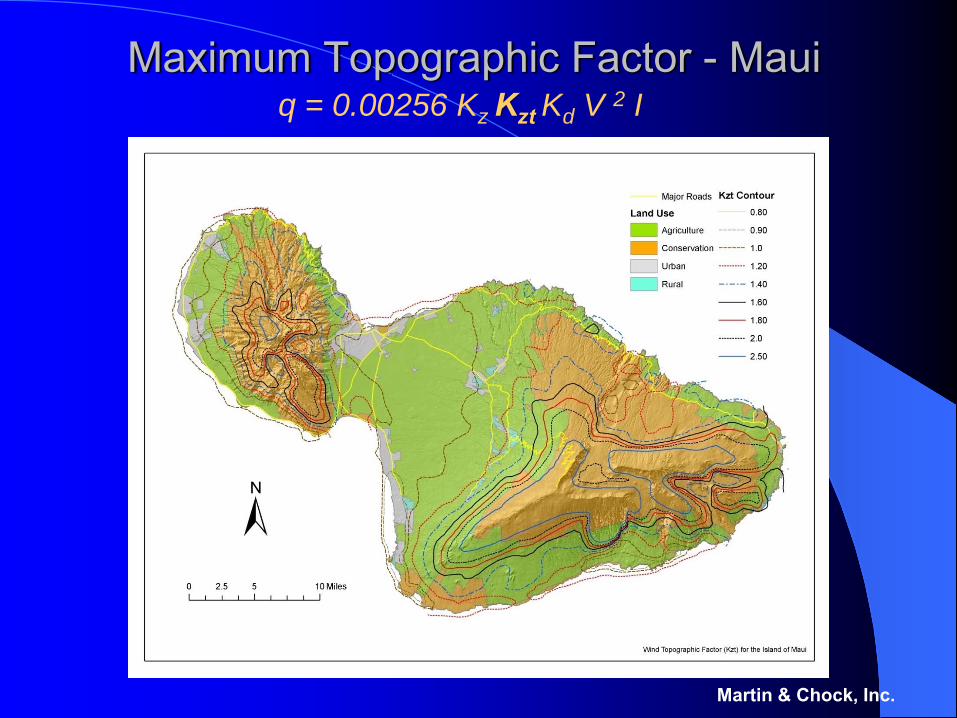
Maximum Topographic Factor - Maui
Martin & Chock, Inc.
q = 0.00256 Kz Kzt Kd V 2 I
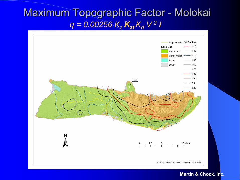
Maximum Topographic Factor - Molokai
Martin & Chock, Inc.
q = 0.00256 Kz Kzt Kd V 2 I
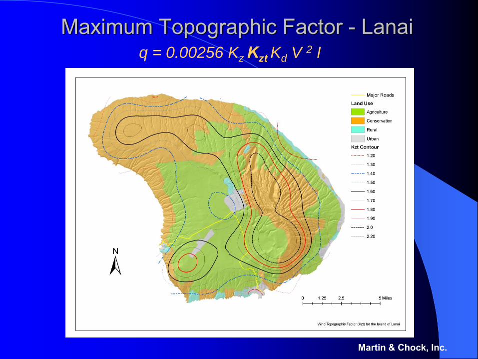
Maximum Topographic Factor - Lanai
Martin & Chock, Inc.
q = 0.00256 Kz Kzt Kd V 2 I
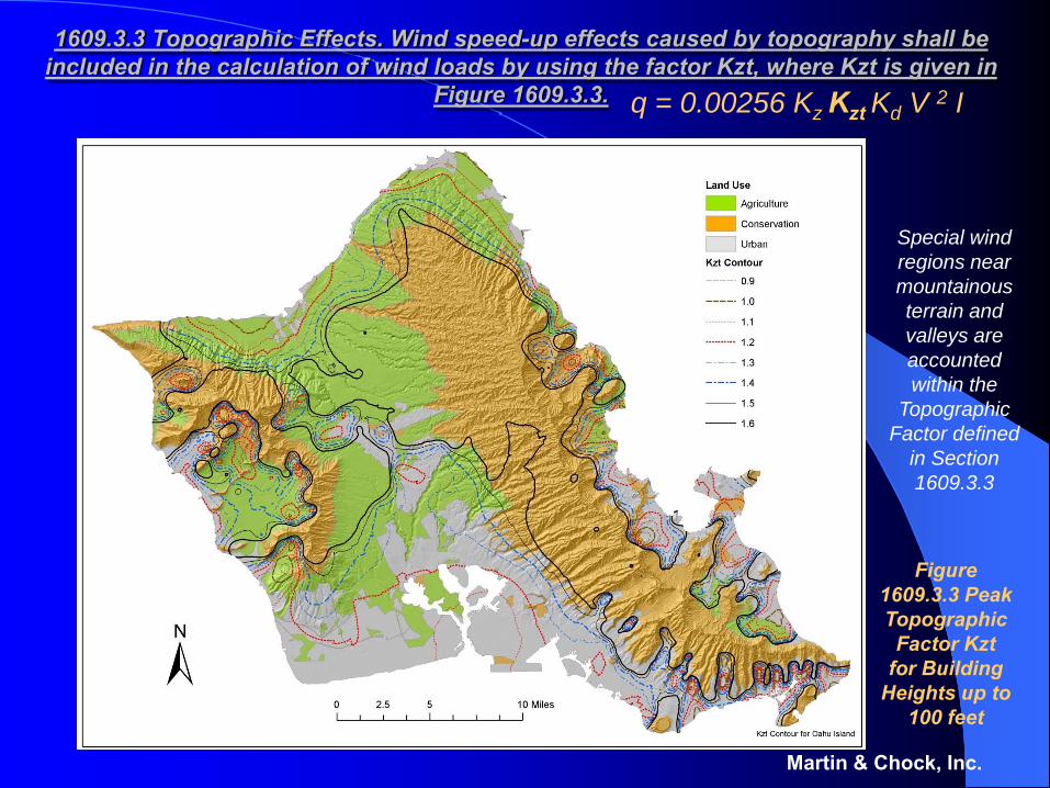
1609.3.3 Topographic Effects. Wind speed-up effects caused by topography shall be included in the calculation of wind loads by using the factor Kzt, where Kzt is given in
Figure 1609.3.3.
Martin & Chock, Inc.
Special wind regions near mountainous terrain and valleys are accounted within the
Topographic Factor defined
in Section 1609.3.3
Figure 1609.3.3 Peak Topographic
Factor Kzt for Building
Heights up to 100 feet
q = 0.00256 Kz Kzt Kd V 2 I

Maximum Topographic Factor - Kauai
Martin & Chock, Inc.
q = 0.00256 Kz Kzt Kd V 2 I
The Relationship between the Maps of Kzt and Tables of Kd
Use of a single map for design representing the maximum Kzt value (of topographic speed-up squared) from any direction would be the simplest to apply but overly conservative.
ASCE provides a basis for making an adjustment of wind load by means of the directionality factor Kd, taking into account the probability that the predominant extreme wind speed-up may not align with the least favorable orientation of a structural component or system
For the Hawaii Building Code a probabilistic adjustment factor Kd is used in a methodology utilizing a single non-directional map of Kt, expressed at 10m , and then accounting for the directional probabilities of wind through specification of Kd based on probabilistic calculations of individual site wind rose data.
Martin & Chock, Inc.
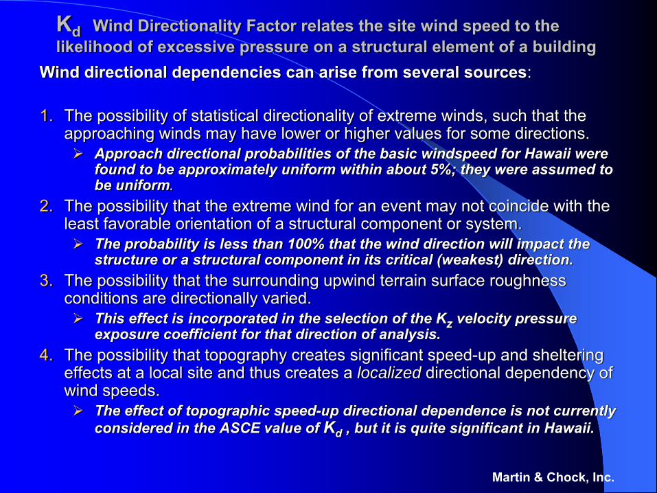
Kd Wind Directionality Factor relates the site wind speed to the likelihood of excessive pressure on a structural element of a building
Wind directional dependencies can arise from several sources:
1. The possibility of statistical directionality of extreme winds, such that the approaching winds may have lower or higher values for some directions.
Approach directional probabilities of the basic windspeed for Hawaii were found to be approximately uniform within about 5%; they were assumed to be uniform.
2. The possibility that the extreme wind for an event may not coincide with the least favorable orientation of a structural component or system.
The probability is less than 100% that the wind direction will impact the structure or a structural component in its critical (weakest) direction.
3. The possibility that the surrounding upwind terrain surface roughness conditions are directionally varied.
This effect is incorporated in the selection of the Kz velocity pressure exposure coefficient for that direction of analysis.
4. The possibility that topography creates significant speed-up and sheltering effects at a local site and thus creates a localized directional dependency of wind speeds.
The effect of topographic speed-up directional dependence is not currently considered in the ASCE value of Kd , but it is quite significant in Hawaii.
Martin & Chock, Inc.
Determination of the Hawaii Directionality Factors, Kd, accounts for all significant sources of directional winds
The ASCE-7 standard includes a directionality factor, Kd, but it is currently based on flat terrain conditions without orographicchanneling and topographic amplification.
The procedure for the Hawaii Building Code will utilize a customized Kd wind directionality factor, which accounts for
Effect 2, that the probability that the maximum wind may not impact the structural component or system in its weakest orientation, Effect 4, that the local wind speeds for the design return period have directional dependence at a site.
Detailed calculations have been performed so that the designer will not have to derive these effects.
Martin & Chock, Inc.
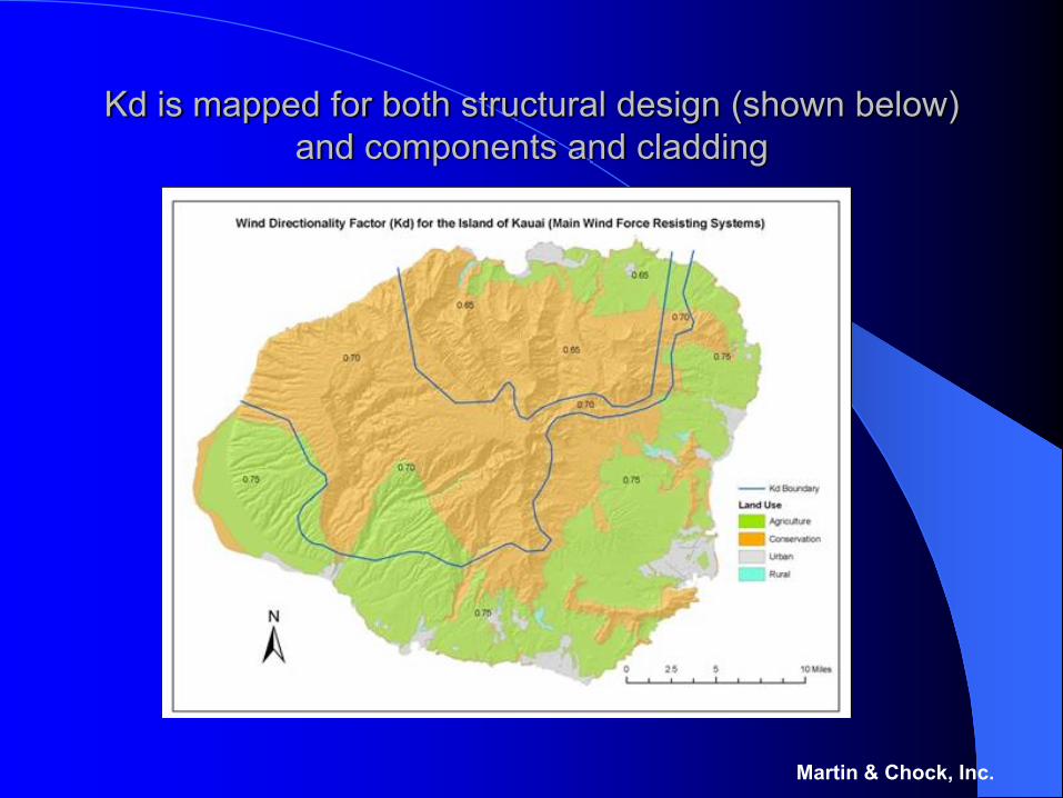
Kd is mapped for both structural design (shown below) and components and cladding
Martin & Chock, Inc.
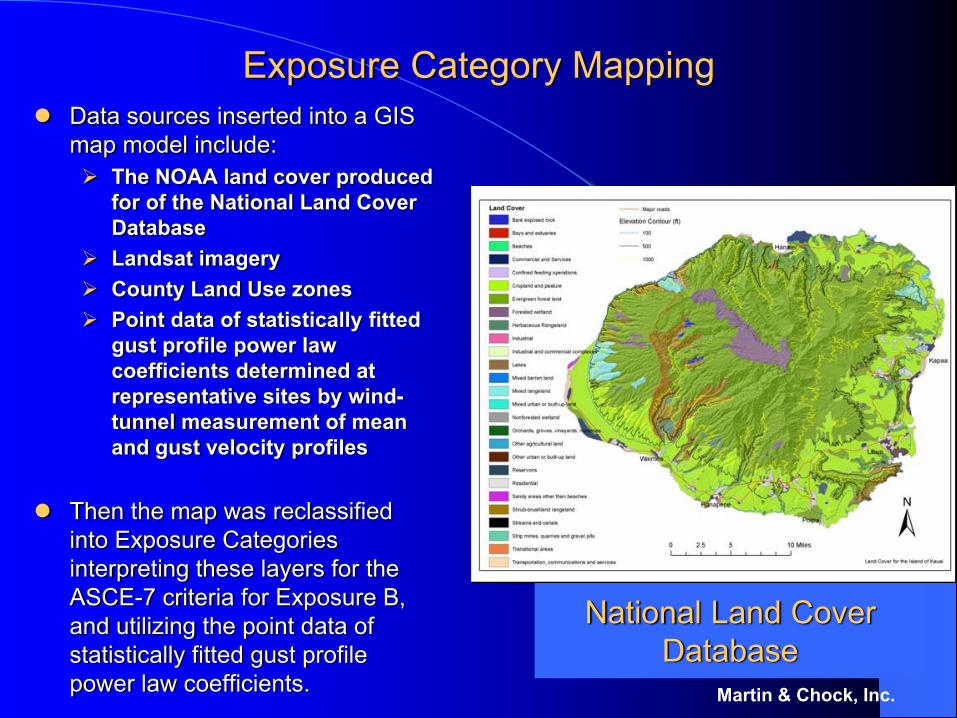
Exposure Category MappingData sources inserted into a GIS map model include:
The NOAA land cover produced for of the National Land Cover Database Landsat imageryCounty Land Use zonesPoint data of statistically fitted gust profile power law coefficients determined at representative sites by wind-tunnel measurement of mean and gust velocity profiles
Then the map was reclassified into Exposure Categories interpreting these layers for the ASCE-7 criteria for Exposure B, and utilizing the point data of statistically fitted gust profile power law coefficients. Martin & Chock, Inc.
National Land Cover Database
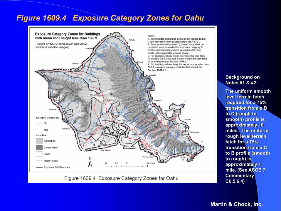
Figure 1609.4 Exposure Category Zones for Oahu
Martin & Chock, Inc.
Background on Notes #1 & #2:
The uniform smooth level terrain fetch required for a 75% transition from a B to C (rough to smooth) profile is approximately 10 miles. The uniform rough level terrain fetch for a 75% transition from a C to B profile (smooth to rough) is approximately 1 mile. (See ASCE 7 Commentary C6.5.6.4)
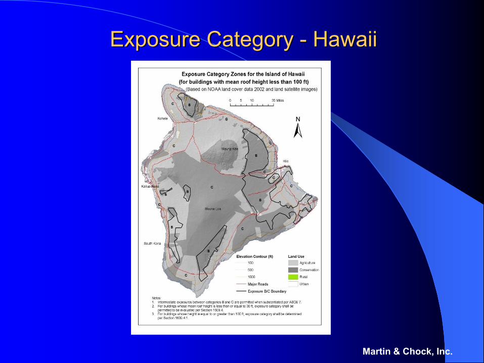
Exposure Category - Hawaii
Martin & Chock, Inc.
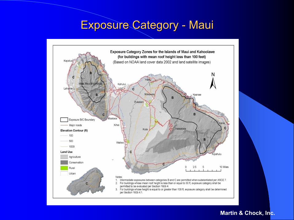
Exposure Category - Maui
Martin & Chock, Inc.
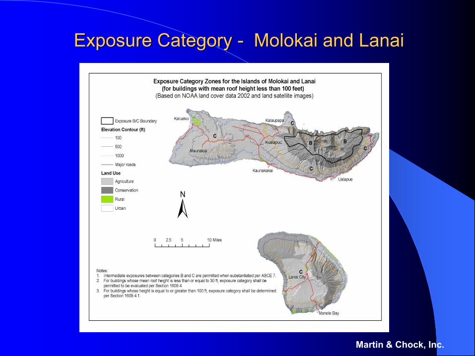
Exposure Category - Molokai and Lanai
Martin & Chock, Inc.
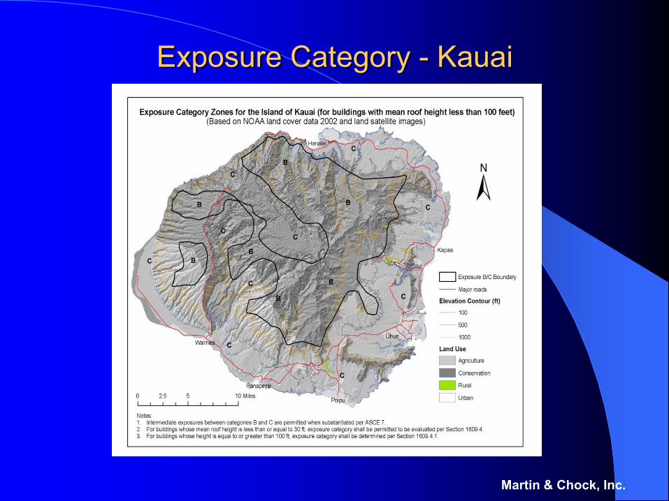
Exposure Category - Kauai
Martin & Chock, Inc.
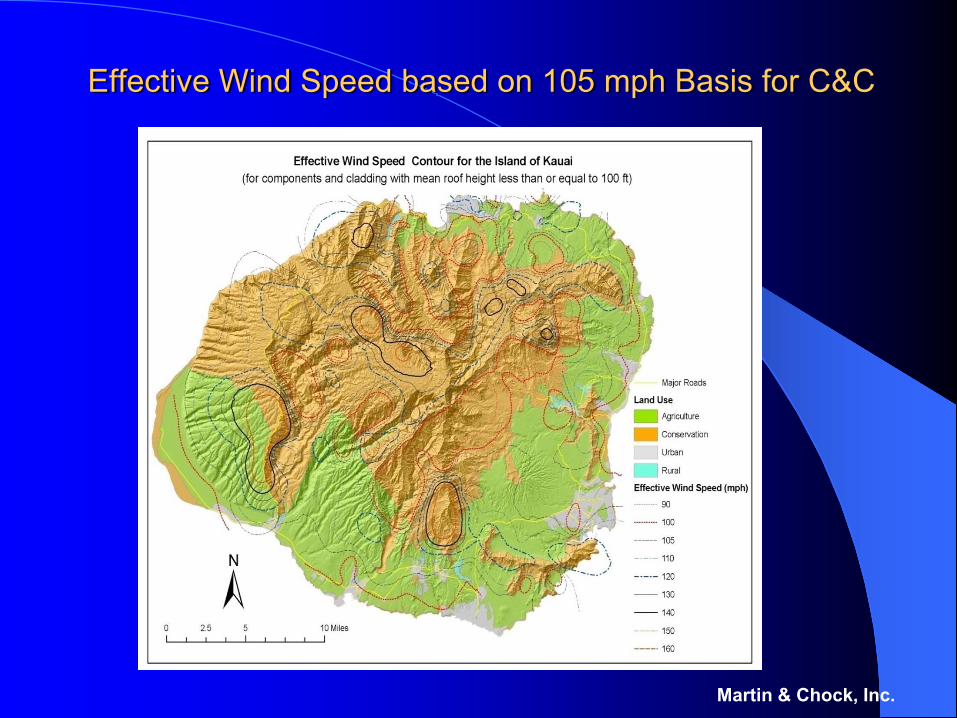
Effective Wind Speed Maps
Algebraically-normalized maps of “Veffective”, i.e., V multiplied by √( Kzt x Kd / 0.85 ) allow implicit consideration of topographic effects for Cladding and Component design.
The Veffective values can be used for performance-specified building components and cladding, as well as when using prescriptive design tables and existing reference standards and simplified methods based on wind speed tables.
Martin & Chock, Inc.
Use of Effective Velocity, Veff
In areas of topographic speed-up, this new velocity term is defined in order to provide a nearly uniform level of protection for hurricane hazard, regardless of whether the designer uses the IBC, Simplified ASCE, or the International Residential Code (IRC), WFCM, etc.
q = 0.00256 Kz Kzt Kd(map) V 2 Iw
Veff = V * √(Kzt x Kdmap / Kd(std) ); Iw = 1.0
q = 0.00256 Kz Kd(std) Veff 2
Consequently, the designer may simply use a map of Veff and the map of Exposure Category.
Martin & Chock, Inc.
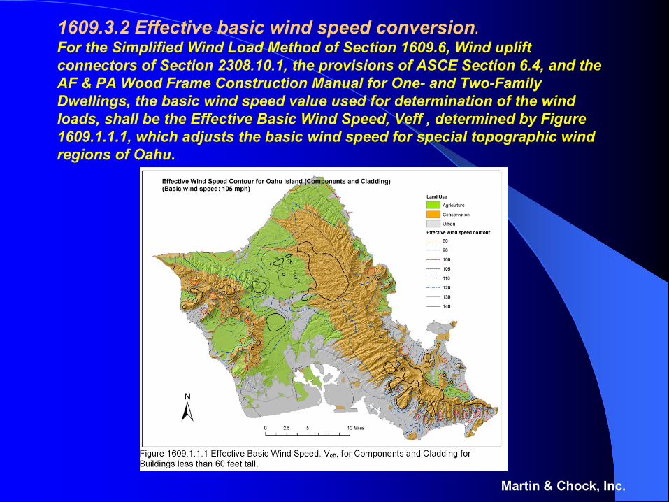
1609.3.2 Effective basic wind speed conversion.For the Simplified Wind Load Method of Section 1609.6, Wind uplift connectors of Section 2308.10.1, the provisions of ASCE Section 6.4, and the AF & PA Wood Frame Construction Manual for One- and Two-Family Dwellings, the basic wind speed value used for determination of the wind loads, shall be the Effective Basic Wind Speed, Veff , determined by Figure 1609.1.1.1, which adjusts the basic wind speed for special topographic wind regions of Oahu.
Martin & Chock, Inc.
Martin & Chock, Inc.
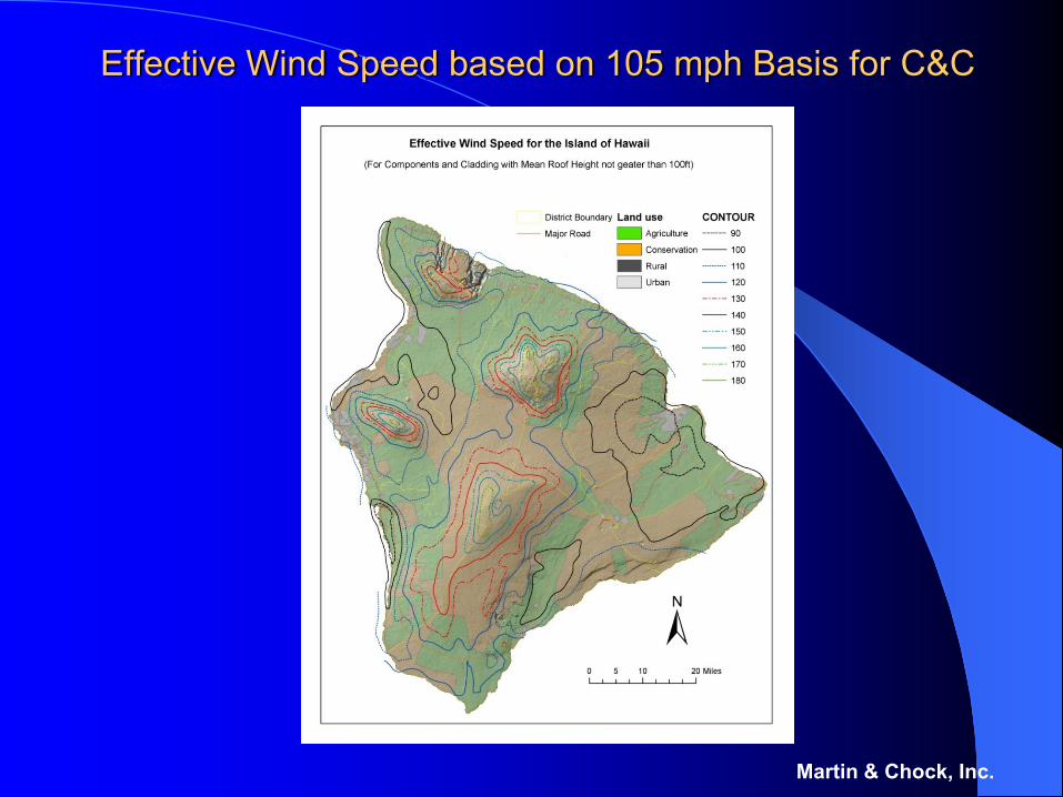
Effective Wind Speed based on 105 mph Basis for C&C
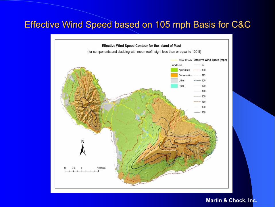
Effective Wind Speed based on 105 mph Basis for C&C
Martin & Chock, Inc.
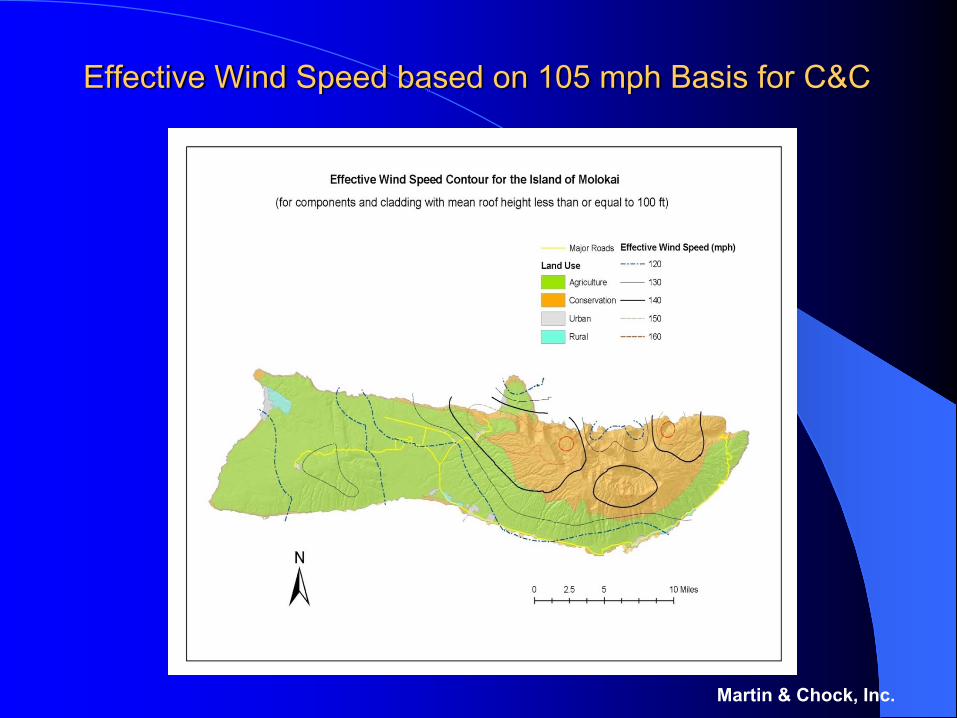
Effective Wind Speed based on 105 mph Basis for C&C
Martin & Chock, Inc.
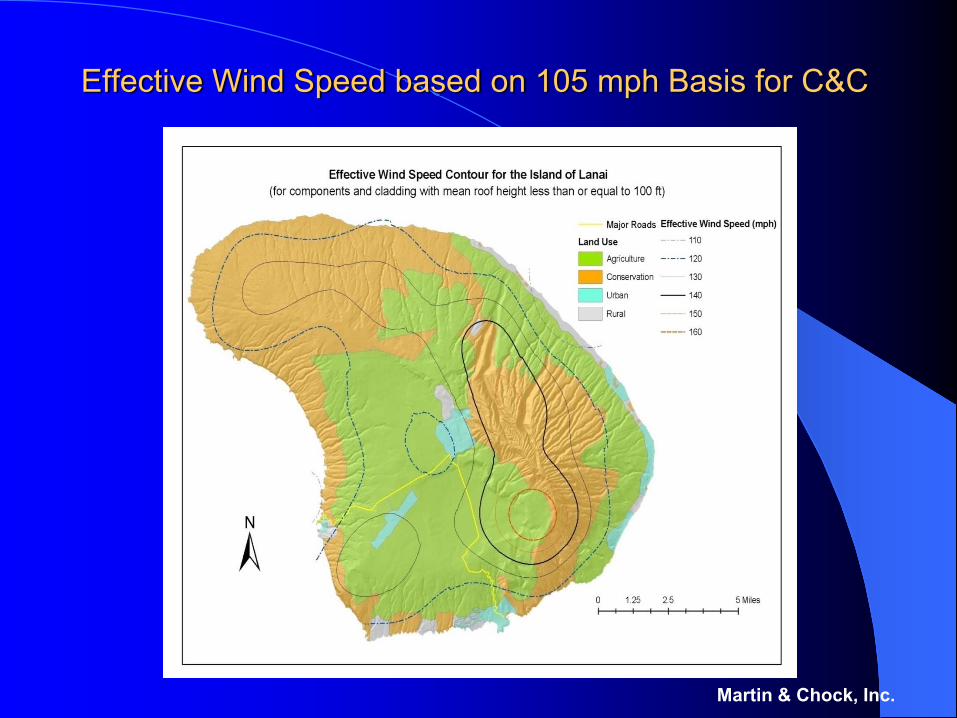
Effective Wind Speed based on 105 mph Basis for C&C
Martin & Chock, Inc.
Effective Wind Speed based on 105 mph Basis for C&C
Martin & Chock, Inc.
Hawaii Design Maps -SummaryTopographic Factor giving the maximum topographic effect due to mountainous topographyTables of Directionality Factor that take into account site directional probabilities of the occurrence of the maximum effectExposure based on Land-cover data developed by the NOAA Coastal Services Center from Landsat Enhanced Thematic Mapper satellite imagery beginning in the year 2000 to provide land cover data for the coastal regions of the National Land Cover Database (NLCD). Effective Wind Speed for Cladding and Components based on 105 mph basic wind speed adjusted for mountainous topographyThe maps are good for the 2003 – 2009 IBC period of adoptions (i.e., up through 2013), with re-calibration of just the effective wind speed maps to occur thereafter to address upcoming ASCE 7-10 revisions.
Martin & Chock, Inc.
SEAOH
A Forthcoming Education/Training PublicationUnique wind conditions are produced by the complex mountainous topography in Hawaii, where each island requires individual maps of these effects for design purposes.A significant portion of the structural engineers engaged in Hawaii building projects are not residents of Hawaii, and all members of the engineering community should have access and guidance on the use of the Hawaii wind design parameters.ICC and SEAOH will collaborate in 2008 and publish a Hawaii Wind Design Handbook that would include all detailed maps and tables of the Hawaii wind parameters in the Hawaii State Code, complete with discussion of their technical derivation and design examples.This publication would be timely with the adoption and training requirements for the Hawaii Statewide Building Code that will utilize the 2006 IBC.It will also include the map updates necessary for the 2012 IBC