Embed Size (px)
Citation preview
Hattah-Kulkyne Lakes Ramsar SiteStrategic Management Plan
Department ofSustainability and Environment
Parks Victoria developed this Strategic Management Plan in conjunction with the Department of Sustainability and Environment and key stakeholders and coordinated the public comment process on the draft document.
This report was prepared with financial support from the National Wetlands Program, under the Natural Heritage Trust.
© The State of Victoria, Department of Sustainability and Environment, 2003 This publication is copyright. Apart from any fair dealing for the purposes of private study, research, criticism or review as permitted under the Copyright Act 1968, no part may be reproduced, copied, transmitted in any form or by any means (electronic, mechanical or graphic) without the prior written permission of the State of Victoria, Department of Sustainability and Environment. All requests and enquires should be directed to the Copyright Officer, Library Information Services, Department of Sustainability and Environment, 240 Victoria Parade, East Melbourne, Victoria 3002. Disclaimers This publication may be of assistance to you and every effort has been made to ensure that the information in the report is accurate. The Department of Sustainability and Environment does not guarantee that the report is without flaw of any kind or is wholly appropriate for your particular purposes and therefore disclaims all liability for any error, loss or other consequence which may arise from you relying on any information in this publication.
The views and opinions expressed in this document are those of the authors and do not necessarily reflect the views and opinions of the Commonwealth Government of Australia, the Federal Minister for Environment and Heritage, or Environment Australia.
This report is prepared without prejudice to any negotiated or litigated outcome of any Native Title Determination Applications covering land or waters within the plan’s area. It is acknowledged that any future outcomes of Native Title Determination Applications may necessitate amendment of this report; and the implementation of this plan may require further notifications under the procedures in Division 3 Part 2 of the Native Title Act 1993 (Cwlth).
The plan is also prepared without prejudice to any future negotiated outcomes between the Government/s and Victorian Aboriginal communities. It is acknowledged that such negotiated outcomes may necessitate amendment of this plan.
Published in July 2003 by the Department of Sustainability and Environment Level 14, 8 Nicholson Street, East Melbourne, Victoria.
Copies of this document are available at www.dse.vic.gov.au
National Library of Australia
Cataloguing-in-Publication entry
Victoria. Department of Sustainability and Environment. Hattah-Kulkyne Lakes Ramsar Site: Strategic Management Plan
Bibliography.
ISBN 1 74106 580 1
Cover: Hattah-Kulkyne National Park (Photograph: Parks Victoria collection).
Printed on recycled paper.
STRATEGIC MANAGEMENT PLAN FOR THE HATTAH-KULKYNE LAKES RAMSAR SITE PAGE I
Contents
1 INTRODUCTION 1
1.1 STRATEGIC DIRECTIONS STATEMENT 1 1.2 PURPOSE OF THE STRATEGIC MANAGEMENT PLAN 1 1.3 CONSULTATIVE FRAMEWORK 2
2 RAMSAR SITE DESCRIPTION 3
2.1 LOCATION 3 2.2 WETLAND TYPE 3 2.3 CRITERIA MET FOR RAMSAR LISTING 3 2.4 LAND TENURE AND MANAGEMENT 3 2.5 ADJACENT LAND USE 5 2.6 CATCHMENT SETTING 5 2.7 LOCAL GOVERNMENT 5
3 POLICY FRAMEWORK 7
3.1 STRATEGIES 7 3.2 MUNICIPAL STRATEGIC STATEMENT, ZONING AND OVERLAYS 8
4 VALUES 9
4.1 WETLAND REPRESENTATIVENESS 9 4.2 FLORA AND FAUNA 9 4.3 WATERBIRDS 9 4.4 NATURAL FUNCTION 9 4.5 CULTURAL HERITAGE 9 4.6 SCENIC 10 4.7 ECONOMIC 10 4.8 EDUCATION AND INTERPRETATION 10 4.9 RECREATION AND TOURISM 10 4.10 SCIENTIFIC 10 4.11 CONDITION 11
5 MANAGEMENT OF RISKS 12
5.1 ALTERED WATER REGIMES 12 5.2 SALINITY 13 5.3 POLLUTION 13 5.4 GRAZING 14 5.5 PEST PLANTS AND ANIMALS 14 5.6 RECREATION 15 5.7 FIRE 16 5.8 LEVEL OF RISK TO RAMSAR VALUES 16
6 SITE MANAGEMENT STRATEGIES 18
REFERENCES 22
STRATEGIC MANAGEMENT PLAN FOR THE HATTAH-KULKYNE LAKES RAMSAR SITE PAGE II
APPENDIX 1 LIST OF CONTRIBUTORS 24
APPENDIX 2 RESOURCE LIST 25
APPENDIX 3 THREATENED STATUS OF FLORA 27
APPENDIX 4 THREATENED STATUS OF FAUNA 28
APPENDIX 5 ACTION STATEMENT RECOMMENDATIONS 30
APPENDIX 6 JAMBA, CAMBA AND BONN SPECIES 31
APPENDIX 7 BREEDING WATERBIRDS 32
APPENDIX 8 PEST PLANT AND ANIMAL SPECIES 33
APPENDIX 9 HATTAH-KULKYNE LAKES RAMSAR INFORMATION SHEET 34
STRATEGIC MANAGEMENT PLAN FOR THE HATTAH-KULKYNE LAKES RAMSAR SITE PAGE 1
1 Introduction
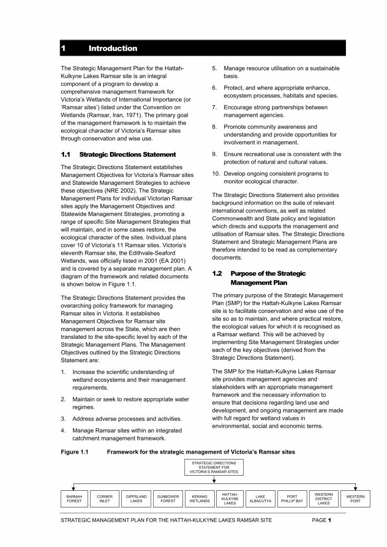
The Strategic Management Plan for the Hattah-Kulkyne Lakes Ramsar site is an integral component of a program to develop a comprehensive management framework for Victoria’s Wetlands of International Importance (or ‘Ramsar sites’) listed under the Convention on Wetlands (Ramsar, Iran, 1971). The primary goal of the management framework is to maintain the ecological character of Victoria’s Ramsar sites through conservation and wise use.
1.1 Strategic Directions Statement
The Strategic Directions Statement establishes Management Objectives for Victoria’s Ramsar sites and Statewide Management Strategies to achieve these objectives (NRE 2002). The Strategic Management Plans for individual Victorian Ramsar sites apply the Management Objectives and Statewide Management Strategies, promoting a range of specific Site Management Strategies that will maintain, and in some cases restore, the ecological character of the sites. Individual plans cover 10 of Victoria’s 11 Ramsar sites. Victoria’s eleventh Ramsar site, the Edithvale-Seaford Wetlands, was officially listed in 2001 (EA 2001) and is covered by a separate management plan. A diagram of the framework and related documents is shown below in Figure 1.1.
The Strategic Directions Statement provides the overarching policy framework for managing Ramsar sites in Victoria. It establishes Management Objectives for Ramsar site management across the State, which are then translated to the site-specific level by each of the Strategic Management Plans. The Management Objectives outlined by the Strategic Directions Statement are:
1. Increase the scientific understanding of wetland ecosystems and their management requirements.
2. Maintain or seek to restore appropriate water regimes.
3. Address adverse processes and activities.
4. Manage Ramsar sites within an integrated catchment management framework.
5. Manage resource utilisation on a sustainable basis.
6. Protect, and where appropriate enhance, ecosystem processes, habitats and species.
7. Encourage strong partnerships between management agencies.
8. Promote community awareness and understanding and provide opportunities for involvement in management.
9. Ensure recreational use is consistent with the protection of natural and cultural values.
10. Develop ongoing consistent programs to monitor ecological character.
The Strategic Directions Statement also provides background information on the suite of relevant international conventions, as well as related Commonwealth and State policy and legislation which directs and supports the management and utilisation of Ramsar sites. The Strategic Directions Statement and Strategic Management Plans are therefore intended to be read as complementary documents.
1.2 Purpose of the Strategic Management Plan
The primary purpose of the Strategic Management Plan (SMP) for the Hattah-Kulkyne Lakes Ramsar site is to facilitate conservation and wise use of the site so as to maintain, and where practical restore, the ecological values for which it is recognised as a Ramsar wetland. This will be achieved by implementing Site Management Strategies under each of the key objectives (derived from the Strategic Directions Statement).
The SMP for the Hattah-Kulkyne Lakes Ramsar site provides management agencies and stakeholders with an appropriate management framework and the necessary information to ensure that decisions regarding land use and development, and ongoing management are made with full regard for wetland values in environmental, social and economic terms.
Figure 1.1 Framework for the strategic management of Victoria’s Ramsar sites
STRATEGIC DIRECTIONSSTATEMENT FOR
VICTORIA’S RAMSAR SITES
CORNERINLET
BARMAHFOREST
GIPPSLANDLAKES
GUNBOWERFOREST
HATTAH-KULKYNE
LAKES
PORTPHILLIP BAY
WESTERNDISTRICT
LAKES
LAKEALBACUTYA
KERANGWETLANDS
WESTERNPORT
STRATEGIC MANAGEMENT PLAN FOR THE HATTAH-KULKYNE LAKES RAMSAR SITE PAGE 2
The SMP has been structured in order to:
• provide a comprehensive site description;
• examine the legislation, policy and any related management instruments which direct or otherwise influence management both within and adjacent to the site;
• clarify the roles and responsibilities of management agencies;
• identify the values for which the site is recognised as a Ramsar site;
• assess threats to these values through systematic analysis of both current and potential risks; and
• give priority to Site Management Strategies that minimise and, where possible, eliminate identified risks to values.
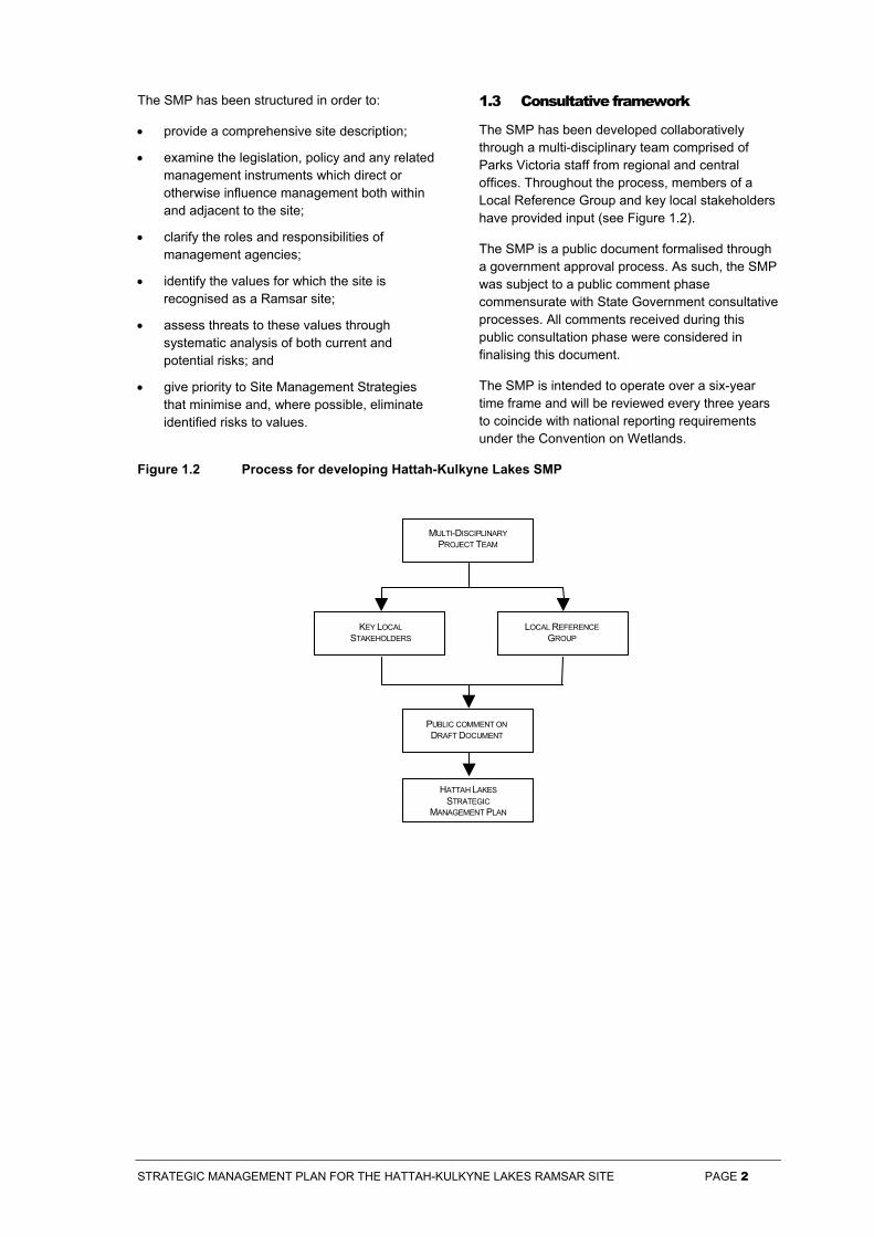
1.3 Consultative framework
The SMP has been developed collaboratively through a multi-disciplinary team comprised of Parks Victoria staff from regional and central offices. Throughout the process, members of a Local Reference Group and key local stakeholders have provided input (see Figure 1.2).
The SMP is a public document formalised through a government approval process. As such, the SMP was subject to a public comment phase commensurate with State Government consultative processes. All comments received during this public consultation phase were considered in finalising this document.
The SMP is intended to operate over a six-year time frame and will be reviewed every three years to coincide with national reporting requirements under the Convention on Wetlands.
Figure 1.2 Process for developing Hattah-Kulkyne Lakes SMP
MULTI-DISCIPLINARYPROJECT TEAM
LOCAL REFERENCEGROUP
KEY LOCALSTAKEHOLDERS
PUBLIC COMMENT ONDRAFT DOCUMENT
HATTAH LAKESSTRATEGIC
MANAGEMENT PLAN
STRATEGIC MANAGEMENT PLAN FOR THE HATTAH-KULKYNE LAKES RAMSAR SITE PAGE 3
2 Ramsar Site Description
2.1 Location
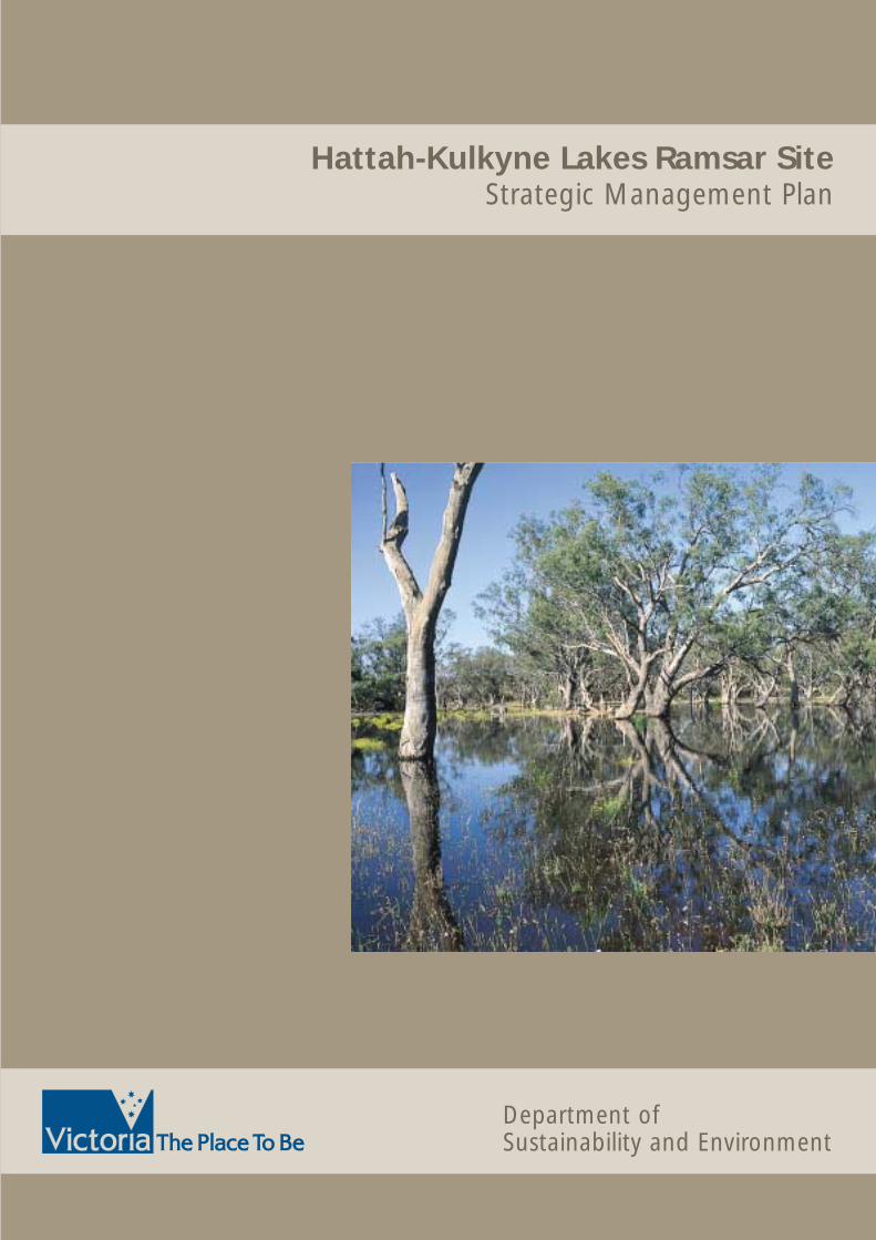
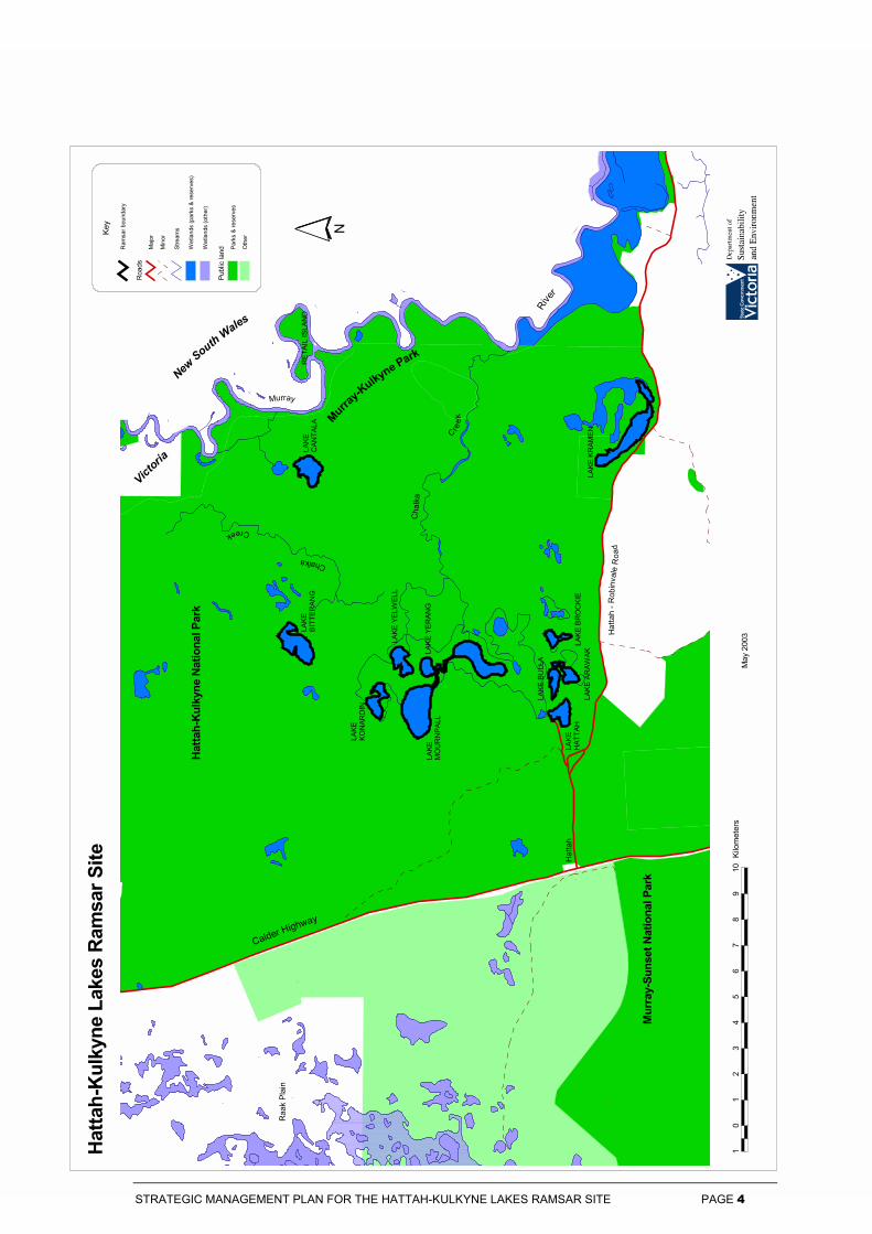
The Hattah-Kulkyne Lakes Ramsar site is located in the Riverina bioregion (Robinvale Plains subregion) approximately 480 km north-west of Melbourne between Ouyen and Mildura. The Hattah-Kulkyne Lakes system form part of the Murray River floodplain and consists mainly of shallow lakes, anabranches and temporary swamps. Only twelve of the lakes are included in the Ramsar site and cover an area of approximately 1,155 ha. The twelve lakes are: Arawak (40 ha); Bitterang (73 ha); Brockie (28 ha); Bulla (40 ha); Cantala (101 ha); Hattah (61 ha); Konardin (121 ha); Kramen (161 ha); Lockie (141 ha); Mournpall (243 ha); Yelwell (81 ha) and Yerang (65 ha).
2.2 Wetland type
Within the Hattah-Kulkyne Lakes Ramsar site two inland wetland types are recognised under the Ramsar Convention. Lakes Arawak, Brockie, Bulla, Hattah, Kramen, Lockie, and Mournpall are classified as permanent freshwater lakes over 8 ha and Lakes Bitterang, Cantala, Konardin, Yelwell and Yerang are classified as seasonal intermittent freshwater lakes over 8 ha including floodplain lakes.
In Victoria wetlands are classified into eight categories (Corrick and Norman 1980). The Hattah-Kulkyne Lakes Ramsar site includes areas of two wetland types under this system: Deep Freshwater Meadow and Permanent Open Freshwater (Table 2.1)
2.3 Criteria met for Ramsar listing
To be listed as a Wetland of International Importance or a ‘Ramsar site’, wetlands must meet one or more internationally accepted criteria in relation to their zoology, botany, ecology, hydrology or limnology and importance to waterfowl. The Ramsar Convention updated the criteria in 1999 (RCB 1999). The new criteria will be applied to Hattah-Kulkyne Lakes when the Ramsar Information Sheet is next updated in 2005. The former criteria met by the Hattah-Kulkyne Lakes site when listed in 1982 were:
2(b) it is of special value for maintaining the genetic and ecological diversity of the flora and fauna of the region;
3(a) it regularly supports >20,000 waterfowl;
3(b) it regularly supports substantial numbers of individuals from particular groups of
waterfowl; and
3(c) it regularly supports 1% of the individuals of a population of one species or subspecies of waterfowl.
Information on how the Hattah-Kulkyne Lakes Ramsar site meets these criteria is detailed in Chapter 4.
2.4 Land tenure and management
The Hattah-Kulkyne Lakes are located within Hattah-Kulkyne National Park. Hattah-Kulkyne National Park is proclaimed under Schedule 2 of the National Parks Act 1975 (Vic). Schedule 2 National Parks are required to be managed in accordance with the following objectives as set out in the National Parks Act:
• to preserve and protect the natural environment including wilderness areas and remote and natural areas in those parks;
• to protect and preserve indigenous flora and fauna and features of scenic or archaeological, ecological or other scientific interest in those parks;
• for the study of ecology, geology, botany, zoology and other sciences relating to the conservation of the natural environment in those parks;
• for the responsible management of the land in those parks; and
• to make provisions in accordance with the foregoing for the use of the parks by the public for the purposes of enjoyment, recreation or education and for the encouragement and control of their use.
The recommendations of the former Land Conservation Council (LCC 1989) also direct the management of the park.
Hattah-Kulkyne National Park is classed as Category II (National Parks) in the International Union for the Conservation of Nature (IUCN) List of National Parks and Protected Areas. IUCN Category II areas are managed primarily for ecosystem conservation and appropriate recreation (NRE 1996).
Parks Victoria manages the Hattah-Kulkyne Lakes Ramsar site. In addition a range of Government agencies are responsible for ensuring that management complies with a broad range of legislative requirements. The successful
$
$$
$$
$
$$
$$
$
$$
$
$$
$
$
$
$
$
$$
$
$
$ $
$
$
$
$$
$
$
$
$$
$$
$$
$
$$
$$
$$
$
$
$
$
LAKE
KONA
RDIN
LAKE
BI
TTER
ANG
LAKE
CA
NTAL
A
LAKE
MOUR
NPAL
L
RETA
IL IS
LAND
LAKE
HATT
AHLA
KE K
RAME
N
LAKE
YEL
WEL
L
LAKE
YER
ANG
LAKE
BUL
LA
LAKE
ARA
WAK
LAKE
BRO
CKIE
Hatta
h-Ku
lkyne
Nat
iona
l Par
k
Hatta
h - R
obin v
ale R
oad
Calder Highway
Murra
y-Su
nset
Nat
iona
l Par
k
Raak
Plai
n
Hatta
h
River
Chalk
a
C reek
Chalka
Creek
Murra
y
Murray-Kulkyne Park
Murray
10
12
34
56
78
910
Kilom
eters
Hatta
h-Ku
lkyne
Lak
es R
amsa
r Site
May 2
003
Victoria
New South Wales
N
Rams
ar bo
unda
ry
Road
sMa
jorMi
nor
Stre
ams
Wetl
ands
(par
ks &
rese
rves)
Wetl
ands
(othe
r)
Publi
c lan
d Park
s & re
serv
esOt
herKe
y
STRATEGIC MANAGEMENT PLAN FOR THE HATTAH-KULKYNE LAKES RAMSAR SITE PAGE 4
STRATEGIC MANAGEMENT PLAN FOR THE HATTAH-KULKYNE LAKES RAMSAR SITE PAGE 5
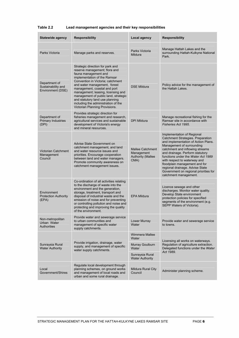
management of the Hattah-Kulkyne Lakes Ramsar site therefore relies on effective cooperation and partnership between the various site and functional managers. Lead management agencies and their key responsibilities are summarised in Table 2.2.
2.5 Adjacent land use
Hattah-Kulkyne National Park is recognised as a Biosphere Reserve under the ‘Man and the Biosphere Program’ of the United National Educational Scientific and Cultural Organisation (UNESCO). Biosphere reserves are areas significant on a world scale for their characteristic landforms, plants and animals, and the way they have been used by people. They have three functions: conservation; sustainable development; and logistic support (in the form of demonstration projects, environmental education and training, research and monitoring related to issues of conservation and sustainable development). Biosphere reserve designation does not alter the legal status of the land and there are no internationally legally binding requirements regarding their management.
Murray-Sunset National Park and Murray-Kulkyne Regional Park abut Hattah-Kulkyne National Park along with State Forest and private land used primarily for dryland cropping, stock grazing and irrigated horticulture.
The Commonwealth Environment Protection and Biodiversity Conservation Act 1999 (EPBC), that came into force on 16 July 2000, identifies Ramsar sites as matters of national environmental significance for which the Commonwealth has a significant responsibility. Wise use principles extend beyond the Ramsar site boundaries. The EPBC Act sets out procedures for assessing actions with potentially significant impacts on Ramsar values, whether these actions are proposed within or outside site boundaries.
2.6 Catchment setting
The Hattah-Kulkyne Lakes Ramsar site is located within the Mallee Catchment. The Mallee
Catchment covers an area of 43,000 km2 and supports a human population of approximately 62,500. The primary land uses in the catchment are dryland and irrigated agriculture and conservation (MCLPB 1997).
The main hydro-ecological feature of the lakes is the large variation in permanency of the aquatic habitats ranging from episodically flooded lakes to almost permanent lakes that receive regular inflows. The Hattah-Kulkyne Lakes System is filled via Chalka Creek, an anabranch of the River Murray. The overall sequence of events during floods is complex, with the filling and emptying of each lake depending on its position in the system, its area, and its depth. The first lake to receive flood waters, several days after they first enter Chalka Creek, is Lake Lockie. All the southern lakes are then filled from Lake Lockie, typically taking another three weeks for water to reach the furthest lakes.
The northern part of the system, Lakes Mournpall, Yerang, Yelwell and Konardin, receives water both directly from Chalka Creek, and via Lake Lockie. Lake Bitterang is the last of the lakes to fill, with flood waters only reaching it over a month after the beginning of flooding, and then only if the flood level is sufficiently high. When the lakes are full, floodwaters also spread over surrounding floodplains, including an area Black Box flats to the west and south-west of Lake Lockie. Lake Kramen fills by overland flow from the Murray in a very high river. Lake Cantala is fed by a minor anabranch of the Murray River
Water retained in lake basins once floodwaters recede is gradually lost through evaporation. Most lakes are shallow, and dry up within two years if not refilled, but Lake Hattah may retain water for three years, and Lake Mournpall for up to seven years (Appendix 9).
2.7 Local Government
The Hattah-Kulkyne Lakes Ramsar site is located within the Mildura Rural City Council.
Table 2.1 Area (ha) of Victorian wetland types present in the Hattah-Kulkyne Lakes Ramsar site
Lake
Wetland Type Ara
wak
Bitt
eran
g
Bro
ckie
Bul
la
Can
tala
Hat
tah
Kon
ardi
n
Kra
men
Lock
ie
Mou
rnpa
ll
Yel
wel
l
Yer
ang
Freshwater meadow (ha) 0 73 0 0 101 0 121 161 0 0 81 65
Permanent open freshwater (ha) 40 0 28 40 0 61 0 0 141 243 0 0
STRATEGIC MANAGEMENT PLAN FOR THE HATTAH-KULKYNE LAKES RAMSAR SITE PAGE 6
Table 2.2 Lead management agencies and their key responsibilities
Statewide agency Responsibility Local agency Responsibility
Parks Victoria Manage parks and reserves. Parks Victoria Mildura
Manage Hattah Lakes and the surrounding Hattah-Kulkyne National Park.
Department of Sustainability and Environment (DSE)
Strategic direction for park and reserve management; flora and fauna management and implementation of the Ramsar Convention in Victoria; catchment and water management, forest management, coastal and port management; leasing, licensing and management of public land, strategic and statutory land use planning including the administration of the Victorian Planning Provisions.
DSE Mildura Policy advice for the management of the Hattah Lakes.
Department of Primary Industries (DPI)
Provides strategic direction for fisheries management and research, agricultural services and sustainable development of Victoria's energy and mineral resources.
DPI Mildura Manage recreational fishing for the Ramsar site in accordance with Fisheries Act 1995.
Victorian Catchment Management Council
Advise State Government on catchment management, and land and water resource issues and priorities. Encourage cooperation between land and water managers. Promote community awareness on catchment management issues.
Mallee Catchment Management Authority (Mallee CMA)
Implementation of Regional Catchment Strategies. Preparation and implementation of Action Plans. Management of surrounding catchment and inflowing streams and drainage. Perform statutory functions under the Water Act 1989 with respect to waterway and floodplain management and for regional drainage. Advise State Government on regional priorities for catchment management.
Environment Protection Authority (EPA)
Co-ordination of all activities relating to the discharge of waste into the environment and the generation, storage, treatment, transport and disposal of industrial waste and the emission of noise and for preventing or controlling pollution and noise and protecting and improving the quality of the environment.
EPA Mildura
Licence sewage and other discharges. Monitor water quality. Develop State environment protection policies for specified segments of the environment (e.g. SEPP Waters of Victoria).
Non-metropolitan Urban Water Authorities
Provide water and sewerage service to urban communities and management of specific water supply catchments.
Lower Murray Water
Provide water and sewerage service to towns.
Wimmera Mallee Water
Murray Goulburn Water
Sunraysia Rural Water Authority
Provide irrigation, drainage, water supply, and management of specific water supply catchments.
Sunraysia Rural Water Authority
Licensing all works on waterways. Regulation of agriculture extraction. Delegated functions under the Water Act 1989.
Local Government/Shires
Regulate local development through planning schemes, on ground works and management of local roads and urban and some rural drainage.
Mildura Rural City Council Administer planning scheme.
STRATEGIC MANAGEMENT PLAN FOR THE HATTAH-KULKYNE LAKES RAMSAR SITE PAGE 7
3 Policy Framework
The suite of relevant international conventions, and the Commonwealth and Victorian legislation and policy that directs management and use of Ramsar sites, are outlined in the Strategic Directions Statement. This Chapter covers the local policy framework comprising plans, strategies and municipal planning provisions as well as statewide strategies approved after publication of the Strategic Directions Statement.
3.1 Strategies
There are a range of existing plans and strategies that provide for the protection and enhancement of the natural and cultural values of the Hattah-Kulkyne Lakes Ramsar site. Victoria has a strong planning framework and as a result these plans and strategies demonstrate a high level of integrated planning and address many aspects of wise use. These plans and strategies are:
• Draft Mallee Regional Catchment Strategy (MCMA 2002);
• Murray River Frontage Action Plan: Robinvale to Merbein (MCMA 2002);
• The Living Murray: Restoring the Health of the Murray River (MDBMC 2002);
• Mallee Waterway and Floodplain Management Strategy (MCMA 2001);
• Floodplains Wetlands Management Strategy (MDBC 1998);
• Mallee Parks Management Plan (NRE 1996)
• Time-Share Flooding of Aquatic Ecosystems (DCNR 1995);
• An Environmental Bulk Water Entitlement for the River Murray (DCNR 1994);
• Mallee Dryland Salinity Management Plan (Beovich 1993);
• Mallee Regional Landcare Plan (Landcare 1993);
• The Integrated Watering Strategy for Mid-Murray Wetlands (Atkins 1993); and
• Mildura Region Fire Protection Plan (DCNR 1992).
(See Appendix 2 for complete references.)
The Murray River Frontage Action Plan Project is an initiative being developed by the Mallee Catchment Management Authority (MCMA) for the Mallee region of Victoria. The project is aimed at planned and coordinated action to improve riparian, floodplain and in-stream conditions along the Murray River in north western Victoria. Frontage Action Plans are being developed for
three reaches of the Murray River between Nyah and the South Australian Border.
The Mallee Waterway Floodplain Management Strategy (MCMA 2001) outlines the strategic basis for managing floodplains in the Mallee including sections on specific areas such as wetlands.
The Hattah Lakes Water Integrated Management Plan is currently being developed by Mallee CMA. The plan will include strategies and actions to restore a more natural flooding regime for the lakes.
Catchment management authorities in Victoria are currently reviewing their regional catchment strategies. The revised regional catchment strategies, once accredited by government, will guide future investment in the catchment under some State natural resource management programs, the National Action Plan for Salinity and Water Quality and the Natural Heritage Trust. This strategic management plan will be recognised under the Mallee Regional Catchment Strategic framework.
Three recently developed statewide strategies are relevant to the management of Hattah-Kulkyne Lakes Ramsar site.
The Victorian River Health Strategy (VRHS) provides a framework that enables Government and community to manage and restore rivers in the State. The VRHS aims to achieve healthy rivers, streams and floodplains which meet the environmental, economic, recreational and cultural needs of current and future generations (NRE 2002d). The VRHS establishes regional planning processes for CMAs to prepare regional river health strategies which will coordinate other river-related action plans and direct the development of annual works programs.
The Indigenous Partnership Strategy (NRE 2001) provides the framework for building effective relationships with Indigenous communities, who have a fundamental role in the management of Victoria’s natural resources, as traditional custodians of the land and waters. This strategy sets out key initiatives to assist in the development and delivery of services to Indigenous people, which should be applied during management planning.
Victoria’s Native Vegetation Management – A Framework for Action (NRE 2002d) establishes the strategic direction for the protection, enhancement
STRATEGIC MANAGEMENT PLAN FOR THE HATTAH-KULKYNE LAKES RAMSAR SITE PAGE 8
and revegetation of native vegetation across the State. The framework focuses on managing native vegetation to provide sustainable landscapes and to protect productive capacity and environmental values of land and water resources.
3.2 Municipal Strategic Statement, zoning and overlays
The Mildura Rural City Council has produced a Municipal Strategic Statement that covers the Hattah-Kulkyne Lakes Ramsar site. Although the Statement addresses a number of important land management and environmental issues, it does not emphasise the environmental values of the Hattah-Kulkyne Lakes Ramsar site and its catchment, or the risks to its values.
Zoning pursuant to the Planning and Environment Act 1987 has been applied to the Hattah-Kulkyne Lakes Ramsar site, as part of a review of local planning schemes, to control land use and development. The Public Conservation and Resource Zone (PCRZ) has been applied to the Hattah-Kulkyne Lakes Ramsar site. The PCRZ is the most appropriate zone for the Ramsar site as it allows for the protection of areas of significance. The PCRZ aims to:
• protect and conserve the natural environment and natural processes for their historic, scientific, landscape, habitat or cultural values;
• provide facilities which assist in public education and interpretation of the natural environment with minimal degradation of the natural environment or natural processes; and
• provide for appropriate resource based uses.
Furthermore, as part of the local planning scheme review, two overlays have been applied to areas within and adjacent to the Ramsar site. Overlays operate in addition to zone requirements and generally concern environmental, landscape, heritage, built form, and land and site management issues. The overlays are Land Subject to Inundation (LSIO) and Environmental Significance Overlay One (ESO1) – Watercourse and Wetlands Protection Area. The purpose of the LSIO is to:
• ensure that development maintains the free passage and temporary storage of floodwaters, minimises flood damage, is compatible with the flood hazard and local drainage conditions and will not cause any significant rise in flood level or flow velocity; and
• protect water quality in accordance with the provision of relevant State Environment Protection Policies, particularly in accordance
with Clauses 33 and 35 of the State Environment Protection Policy (Waters of Victoria).
The environmental objectives of the ESO1 include:
• to protect and enhance the natural environmental qualities of the Murray River and its anabranches as a major waterway of local, regional, state, national and international significance;
• to ensure that any use, development or works along or adjacent to the Murray River is of a scale, character and form which is compatible with the high environmental quality of this watercourse;
• to promote tourist and recreational activities adjacent to the river provided various design and planning considerations are met; and
• to limit urban development in those areas subject to flooding adjacent to the Murray River.
A further vegetation protection overlay has been agreed to by the Mildura Rural City Council to be applied over areas adjacent to the Hattah-Kulkyne Lakes for the protection of the Regent Parrot which is threatened in Victoria.
STRATEGIC MANAGEMENT PLAN FOR THE HATTAH-KULKYNE LAKES RAMSAR SITE PAGE 9
4 Values
The key environmental values of the Hattah-Kulkyne Lakes Ramsar site for which it was listed (representativeness, flora and fauna and waterbirds) are summarised below. Other values described include natural function, cultural heritage, scenic, economic, education and interpretation, recreation and tourism and scientific.
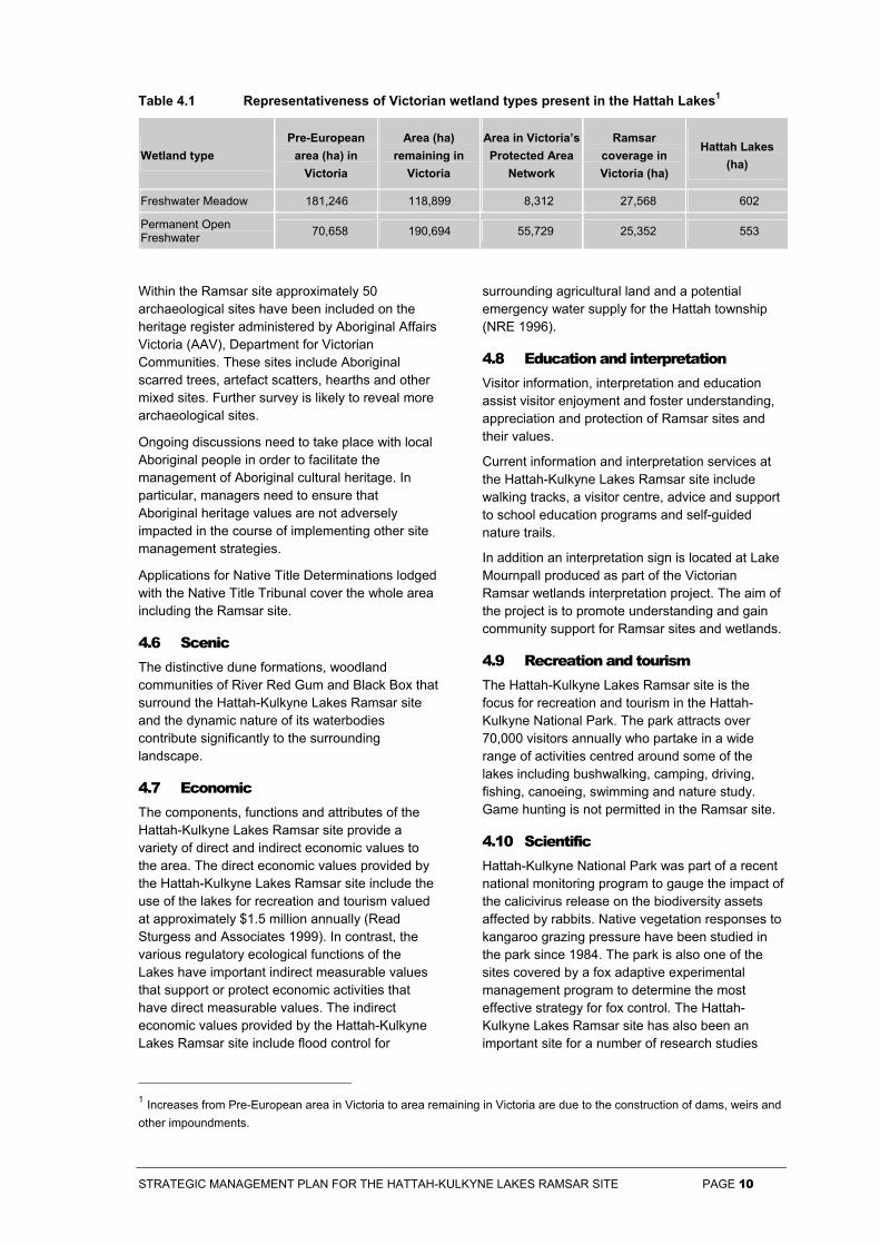
4.1 Wetland representativeness
In Victoria wetlands are classified into eight categories. The Hattah-Kulkyne Lakes Ramsar site includes areas of two wetland types under this system: Deep Freshwater Meadow and Permanent Open Freshwater. Deep Freshwater Meadow is one of the State’s most depleted wetland habitats and is the least represented in Victoria’s protected area network (Table 4.1).
4.2 Flora and fauna
Flora
More than 100 species of indigenous flora have been recorded at the Hattah-Kulkyne Lakes Ramsar site. Six flora species considered to be threatened in Victoria have been recorded in the Ramsar site. One of the species recorded is listed under the Flora and Fauna Guarantee Act 1988 (Vic) (Appendix 3).
Fauna
More than 120 species of indigenous fauna have been recorded at the Hattah-Kulkyne Lakes Ramsar site. Of these, 2 fauna species are considered to be nationally threatened under the Commonwealth’s Environment Protection and Biodiversity Conservation Act 1999. A total of 39 fauna species considered to be threatened in Victoria have been recorded. Twenty seven of the species recorded are listed under the Flora and Fauna Guarantee Act 1988, 4 of these as part of the Lowland Riverine Fish Community of the Southern Murray-Darling Basin. Action Statements have been prepared for 3 of these species (Appendix 4).
A total of 6 bird species listed under the Japan-Australia Migratory Birds Agreement (JAMBA) and 11 species under the China-Australia Migratory Birds Agreement (CAMBA) have been recorded at
the Ramsar site (Appendix 6). Ten species listed under the Bonn Convention on Conservation of Migratory Species of Wild Animals have also been recorded at the Ramsar site (Appendix 6).
4.3 Waterbirds
The Hattah-Kulkyne Lakes Ramsar site provides important feeding, resting and breeding habitat for more than 47 waterbird species.
In terms of carrying capacity up to 288 Hoary-headed Grebes, 101 Freckled Duck, 1,960 Pacific Black Duck, 2,550 Grey Teal, 1,280 Pink-eared Duck, 128 Black-fronted Dotterel and 1,000 Australian Pelicans have been counted at the lakes (ANCA 1996).
A total of 18 waterbird species have been recorded breeding at the Hattah-Kulkyne Lakes Ramsar site (Appendix 7). Of these species 16 are threatened in Victoria, 8 are listed under the Flora and Fauna Guarantee Act 1988, 2 under the Bonn Convention, and 1 under CAMBA.
The Hattah-Kulkyne Lakes Ramsar site also provides drought refuge for waterbirds, reflecting the prevalence of permanent water within the wetland system.
4.4 Natural function
The Hattah-Kulkyne Lakes Ramsar site is a natural flood mitigation area, storing excess run-off and releasing it slowly through evaporation. The wetlands act as a sink, or store, for sediments and nutrients washed from the surrounding catchment.
4.5 Cultural heritage
The Hattah-Kulkyne Lakes Ramsar site has been a focus for traditional Aboriginal society for thousands of years. The Lakes provided reliable sources of water as well as a rich and diverse supply of plant and animal resources for food, medicines, shelter, clothing and tools.
All Aboriginal sites, places and objects are protected under the Archaeological and Aboriginal Relics Preservation Act 1972 (Vic.) and the Aboriginal and Torres Strait Islander Heritage Protection Act 1984 (Cwlth).
STRATEGIC MANAGEMENT PLAN FOR THE HATTAH-KULKYNE LAKES RAMSAR SITE PAGE 10
Table 4.1 Representativeness of Victorian wetland types present in the Hattah Lakes1
Wetland type Pre-European
area (ha) in Victoria
Area (ha) remaining in
Victoria
Area in Victoria’s Protected Area
Network
Ramsar coverage in Victoria (ha)
Hattah Lakes (ha)
Freshwater Meadow 181,246 118,899 8,312 27,568 602
Permanent Open Freshwater 70,658 190,694 55,729 25,352 553
1 Increases from Pre-European area in Victoria to area remaining in Victoria are due to the construction of dams, weirs and other impoundments.
Within the Ramsar site approximately 50 archaeological sites have been included on the heritage register administered by Aboriginal Affairs Victoria (AAV), Department for Victorian Communities. These sites include Aboriginal scarred trees, artefact scatters, hearths and other mixed sites. Further survey is likely to reveal more archaeological sites.
Ongoing discussions need to take place with local Aboriginal people in order to facilitate the management of Aboriginal cultural heritage. In particular, managers need to ensure that Aboriginal heritage values are not adversely impacted in the course of implementing other site management strategies.
Applications for Native Title Determinations lodged with the Native Title Tribunal cover the whole area including the Ramsar site.
4.6 Scenic The distinctive dune formations, woodland communities of River Red Gum and Black Box that surround the Hattah-Kulkyne Lakes Ramsar site and the dynamic nature of its waterbodies contribute significantly to the surrounding landscape.
4.7 Economic The components, functions and attributes of the Hattah-Kulkyne Lakes Ramsar site provide a variety of direct and indirect economic values to the area. The direct economic values provided by the Hattah-Kulkyne Lakes Ramsar site include the use of the lakes for recreation and tourism valued at approximately $1.5 million annually (Read Sturgess and Associates 1999). In contrast, the various regulatory ecological functions of the Lakes have important indirect measurable values that support or protect economic activities that have direct measurable values. The indirect economic values provided by the Hattah-Kulkyne Lakes Ramsar site include flood control for
surrounding agricultural land and a potential emergency water supply for the Hattah township (NRE 1996).
4.8 Education and interpretation Visitor information, interpretation and education assist visitor enjoyment and foster understanding, appreciation and protection of Ramsar sites and their values.
Current information and interpretation services at the Hattah-Kulkyne Lakes Ramsar site include walking tracks, a visitor centre, advice and support to school education programs and self-guided nature trails.
In addition an interpretation sign is located at Lake Mournpall produced as part of the Victorian Ramsar wetlands interpretation project. The aim of the project is to promote understanding and gain community support for Ramsar sites and wetlands.
4.9 Recreation and tourism The Hattah-Kulkyne Lakes Ramsar site is the focus for recreation and tourism in the Hattah-Kulkyne National Park. The park attracts over 70,000 visitors annually who partake in a wide range of activities centred around some of the lakes including bushwalking, camping, driving, fishing, canoeing, swimming and nature study. Game hunting is not permitted in the Ramsar site.
4.10 Scientific Hattah-Kulkyne National Park was part of a recent national monitoring program to gauge the impact of the calicivirus release on the biodiversity assets affected by rabbits. Native vegetation responses to kangaroo grazing pressure have been studied in the park since 1984. The park is also one of the sites covered by a fox adaptive experimental management program to determine the most effective strategy for fox control. The Hattah-Kulkyne Lakes Ramsar site has also been an important site for a number of research studies
STRATEGIC MANAGEMENT PLAN FOR THE HATTAH-KULKYNE LAKES RAMSAR SITE PAGE 11
particularly in the fields of floodplain ecology and hydrology.
As previously mentioned under section 2.5, the Hattah-Kulkyne Lakes Ramsar site is also part of a Biosphere Reserve. Research under the Program is designed to produce the information needed to solve practical problems of resource management. Programs for the Reserve are yet to be developed.
4.11 Condition
Vegetation Since European settlement the structure and composition of the vegetation around the Hattah-Kulkyne Lakes Ramsar site has been severely modified by domestic stock and native animal grazing, logging and the introduction of exotic flora and fauna.
Within the Ramsar site the vegetation is dominated by lakebed herbfield species such as Southern Liquorice, Sneezeweed and Lesser Joyweed.
The vegetation around the lakes is dominated largely by Black Box, River Red Gum and Eumong, present as small trees with patches of Tangled Lignum up to 3m in height. The shrub layer is composed primarily of chenopod shrubs such as Ruby Saltbush, Copper Burrs and Bluebush. Where grazing has been excluded, native perennial grasses are common and frequently form a large proportion of the understorey (Sluiter et al. 1997). The remaining proportion of the understorey (up to 10%) is comprised largely of exotic flora.
Water quality Water quality in the Hattah-Kulkyne Lakes Ramsar site in terms of dissolved oxygen, pH and heavy metals (arsenic, cadmium, chromium, copper, lead, zinc) is generally good and complies with State Environment Protection Policy (SEPP) water quality objectives (EAP 1985) and Australian and New Zealand Environment and Conservation Council water quality guidelines (ANZECC 1992). Conversely, water quality in terms of nutrients (total nitrogen and total phosphorus) and chlorophyll-a is generally poor (Water ECOscience Pty Ltd 1996) (Souter 1996).
STRATEGIC MANAGEMENT PLAN FOR THE HATTAH-KULKYNE LAKES RAMSAR SITE PAGE 12
5 Management of Risks
The key risks to the environmental values at the Hattah-Kulkyne Lakes Ramsar site are discussed below. The risks include altered water regimes, salinity, pollution, grazing, pest plants and animals, recreation and fire, which were in some cases established prior to the listing of the site.
These risks result from activities in the wetland, on adjoining land and in the catchment. Protection of the site therefore requires an integrated approach. A wide variety of measures are being implemented at the Hattah-Kulkyne Lakes Ramsar site to deal with risks. They include planning, research, site works, catchment works and education. A brief summary of these measures relevant to each risk is provided.
5.1 Altered water regimes
The Hattah Lakes system is a series of perennial and intermittent freshwater lakes fed from the Murray River via Chalka Creek. There have been substantial changes to the hydrological regime of the Hattah Lakes system due to the regulation and modification of flow in the Murray River and structural and earthworks in the Chalka Creek (Cumming and Lloyd 1993).
The flows of the Murray River are regulated by a series of weirs, locks and dams along its length. Modifications to Chalka Creek include deepening and regrading of the channel and the installation of a regulator at Messengers to prevent floodwater from receding (NRE 1996). Internal modifications to the Hattah Lakes system include the construction of a channel between Lockie and Hattah Lakes, and the installation of an earthen bank and a drop-board regulator between Hattah and Little Hattah.
The effects of these changes on the Hattah Lakes system have been:
• a reduction in the flooding frequency by 57%. Instead of an average return period of 1.5 years under natural conditions, the current return period is estimated to be 3.7 years (Cumming and Lloyd 1993);
• a reduction in the flooding duration by 65% (Cumming and Lloyd 1993);
• a delay in the timing of flooding. Under natural conditions the most common month of flood initiation was August. Under current conditions, October has become the most common month of flood initiation (Cumming and Lloyd 1993);
• Changes to the drying regime of Lake Hattah. Since 1970 Lake Hattah has been dry for a short period in 1989, for 13 months between September 1999 and October 2000 and refilled in November 2000. The natural frequency of drying for Lake Hattah is estimated to be once every seven years (Cumming & Lloyd 1993); and
• Changes to the natural hydrological regime of the Hattah Lakes system have had a number of impacts upon native flora and fauna.
There is no evidence of widespread dieback of flood-dependent vegetation around the Lakes, although pockets of dieback, possibly due to length of inundation, rising groundwater and water stress between floods, have been recorded (P. Murdoch pers. comm.). The distribution of flood-dependent woody vegetation may also be changing with evidence of regeneration of both River Red Gum and Black Box (NRE 1996).
The changed hydrological regime is likely to have altered faunal habitat leading to lower recruitment rates within some bird, fish and macroinvertebrate populations dependent upon certain flooding regimes (Cumming and Lloyd 1993).
Permanent inundation may also favour the proliferation of European Carp, which are thought to degrade waterbird habitat by muddying water and preventing the growth of aquatic plants.
The high flow necessary in the Murray River before water enters Chalka Creek and then flows to the lakes is a significant constraint on the management of this site. As a result, management and control of the Murray is an integral part of establishing a water management plan for the lakes.
The impacts associated with altered water regimes are being addressed by scientific studies into the hydrology and biology of the Hattah Lakes, such as the Hattah Lakes Water Management Plan being developed by the Mallee Catchment Management Authority (Mallee CMA unpubl.). When complete this document will provide the basis for managing water in the Hattah-Kulkyne Lakes system.
River Murray Bulk Entitlements were completed in 1999. The Bulk Entitlement (River Murray – Flora and Fauna) Conversion Order 1999 provides an allocation of 27,600 ML for use along the Murray River to meet environmental objectives. DSE has
STRATEGIC MANAGEMENT PLAN FOR THE HATTAH-KULKYNE LAKES RAMSAR SITE PAGE 13
an environmental water allocation program that assigns water to wetlands according to their conservation status, required hydrological regime and other factors. The Hattah Lakes area, which includes the Hattah-Kulkyne Lakes Ramsar site, is one of the systems targeted for this program. However, the conditions under which water could be transferred into this system occur so infrequently that this allocation is unlikely to be used at Hattah-Kulkyne with the existing infrastructure.
The Murray-Darling Basin Commission is currently exploring the different effects of securing 350, 750 or 1500 GL of additional environmental flows for the Murray River as part of their Living Murray Project. The project is also investigating the most sustainable methods of water use to ensure the maximum amount of water is available to benefit the environment without adversely impacting on local communities.
5.2 Salinity
Approximately 60% of the vegetation in the Mallee has been cleared for agriculture which has resulted in increased recharge and subsequent rising of saline groundwater. Low-lying areas such as the Hattah-Kulkyne Lakes Ramsar site are at threat from a further rise in groundwater. The Mallee Dryland Draft Salinity Management Plan (MDCWG1993) predicts Lakes Bitterang, Konardin, Yelwell and Hattah are all at risk of becoming salt-affected.
Increases in salinity levels of the Hattah Lakes may threaten the habitat of fish and aquatic invertebrates, which in turn provide food for waterbirds. Raised salinity levels also favour certain blue green algae, increasing the likelihood and severity of algal blooms.
Catchment works carried out as part of a number of catchment strategies, including the Mallee Regional Catchment Strategy and the Mallee Dryland Salinity Management Plan, address the impacts associated with salinity. This is balanced by regular groundwater monitoring carried out by Wimmera Mallee Water, DPI and the local community.
Across the Murray Darling Basin, salinity is targeted through the Salinity and Drainage Strategy (MDBMC 1989). This strategy attempted to control salinity through:
• salt interception schemes to reduce river salinity;
• new operating rules for water storage to reduce the loss of water through evaporation and thereby reduce river salinities;
• the development of improved land management techniques, more efficient irrigation technology, and new crops for saline environments; and
• land management schemes to control land salinity and waterlogging on the Riverine Plain upstream of Echuca.
This strategy has achieved a net reduction in salinity within the Murray River over the past decade and is attempting to build on this into the future (MDBMC 1999). The reduction achieved is the result of coordination and cooperation between the Commonwealth, New South Wales, South Australia and Victorian governments and the community.
Along with this strategy, the Mallee Catchment Management Authority is developing a Salinity and Water Quality Management Plan. This plan is a review of the 4 existing salinity plans that cover the Mallee Catchment Management Area and will provide the direction for salinity management within and around the Hattah-Kulkyne Ramsar site.
5.3 Pollution The major sources of nutrients identified in the Mallee are irrigation drainage, urban stormwater run-off, effluent from sewerage treatment plants, septic tanks, water based recreation, livestock access to water frontages and soil erosion (Mallee CALP 1997).
The transport of nutrients into the Hattah-Kulkyne Lakes Ramsar site occurs during floods and other high streamflow events when the lakes are recharged with water from Chalka Creek. The increase in nutrient levels in the waters of the Murray River, primarily due to intensive land use within its catchment, has produced a nutrient enrichment in the Hattah Lakes system. As a result, the incidence and severity of algal blooms in the lakes have increased.
Algal blooms pose a number of problems. The discolouration of the water and the pungent tastes, odours and unsightly scums associated with algal blooms degrades the aesthetic appeal and the recreational value of the lakes.
Some species of blue-green algae produce toxins, which can have serious health implications for recreational users, and terrestrial and aquatic fauna contacting or drinking contaminated water.
Finally, when algal blooms can no longer be sustained the algal cells begin to die and decompose. As bacteria decompose the algal cells the process uses up oxygen in the surrounding water. This lowers the dissolved oxygen level in
STRATEGIC MANAGEMENT PLAN FOR THE HATTAH-KULKYNE LAKES RAMSAR SITE PAGE 14
the water, which can be detrimental to the survival of oxygen dependent biota such as fish.
The impacts associated with pollution are being addressed through a range of measures including the participation of management agencies in statutory planning processes and community water quality monitoring programs. In addition, the Mallee Catchment Management Authority is currently developing the Mallee Water Quality and Salinity Management Plan.
5.4 Grazing
A past history of livestock grazing before the national park was declared as well as excessive grazing pressure by rabbits, goats, western grey kangaroos and red kangaroos have degraded native vegetation and hence faunal habitat around the Hattah-Kulkyne Lakes Ramsar site.
Grazing pressure has suppressed the regeneration of woody species and has resulted in reduced abundance of perennial taxa in the shrub and ground layers including the threatened Sand Sida, Silky Glycine, Upright Adder’s Tongue, Hooked Needlewood and the Prickly Bottlebrush.
The depletion of understorey vegetation reduces the availability of ground cover for ground dwelling fauna, including the Flora and Fauna Guarantee Act listed Spotted Bowerbird, which may expose them to increased rates of predation. Soil disturbance, and changes in soil nutrient status caused by intensive grazing, favour some introduced species over their native counterparts and help to perpetuate the spread of weeds (Westbrooke 1990; Cheal et al. 1992; Cheal 1993). Other impacts include trampling of vegetation, soil erosion and soil compaction.
A kangaroo management program was initiated within Mournpall Block of Hattah-Kulkyne National Park in 1990. The kangaroo density within Mournpall block has now been reduced to an estimated 5 per km2 from an estimated high of 46 per km2 in 1990. Mournpall Block contains nine of the twelve lakes listed as part of the Ramsar site. Only Lake Bitterang, Lake Cantala and Lake Kramen are located outside the Mournpall Block. Kangaroo control commenced outside Mournpall Block in 1996. Rabbit numbers within the Hattah-Kulkyne Lakes Ramsar site have also been reduced significantly due to active park and community control programs commencing in the mid 1980s and the introduction of the rabbit calicivirus disease in the 1990s.
As a result of reduced grazing pressure by kangaroos and rabbits, regeneration of some
woody species and a suite of perennial sub-shrubs, herbs and grasses, including some rare or threatened plants, have been recorded within and outside the Mournpall Block (Sluiter et al. 1992) (P. Murdoch pers. comm.).
The number and impact of feral goats within the Hattah-Kulkyne Lakes Ramsar site is largely unknown. However, their preferential grazing habit may remove those plants critical to the survival of some native animal species. The social nature of goats can also lead to localised impacts on vegetation, especially near frequently used night camps. Goat numbers in Hattah-Kulkyne National Park are currently controlled through trapping and opportunistic shooting. The kangaroo fence surrounding the Mournpall Block enabled the exclusion of feral goats from most lakes between 1982 and 2001. Since 2001 a small population of approximately 40 goats has been recorded inside the Mournpall Block.
5.5 Pest plants and animals
Pest plants recorded in the Hattah-Kulkyne Lakes Ramsar site can be divided into two categories:
• agricultural weeds including Thorn Apple, Field Dodder, Noogoora Burr and Bathurst Burr; and
• environmental weeds including Horehound, Bridal Creeper, Common Thornapple, Paterson’s Curse, Tree Tobacco, Olive and various introduced annual grasses.
Horehound and Thornapple are the most predominant weed species. They account for approximately 5% of ground layer vegetation around the perimeter of the lakes. The remaining weed species generally occur as scattered individuals.
Pest plants are of concern, particularly environmental weeds, because they reduce opportunities for regeneration of indigenous flora through competitive growth and by changing soil conditions required for successful germination and development. Flora species at greatest risk from weed invasion include those of highest conservation significance including the Garland Lily and the Sand Sida.
A number of introduced animals have been recorded at the Hattah-Kulkyne Lakes Ramsar site. Problem species include European Carp, foxes, rabbits, goats and pigs. The threats posed by feral rabbits and goats are outlined in Section 5.4.
Large numbers of carp enter the Hattah-Kulkyne Lakes Ramsar site from the Murray River via
STRATEGIC MANAGEMENT PLAN FOR THE HATTAH-KULKYNE LAKES RAMSAR SITE PAGE 15
Chalka Creek. The feeding strategy of carp can result in increased water turbidity and the destruction of submerged aquatic vegetation that provide food and shelter for native fishes and habitat for waterbirds (Barnham 1998). Muddying the water makes the environment unsuitable for many of the aquatic biota that naturally thrives in the lakes.
Predation of native wildlife by foxes is listed as a threatening process under the Flora and Fauna Guarantee Act 1988. Foxes are widespread throughout the Hattah-Kulkyne Lakes Ramsar site and the following categories of native fauna are considered to be at risk from predation:
• arboreal mammals including Brushtail and Western Pygmy possums;
• bird species that spend much of their time at or near the ground nesting and/or feeding including the threatened Freckled Duck, Blue-billed duck, Apostlebird, Spotted Bowerbird and Mallee Emu-wren;
• reptiles including the threatened Carpet Python; and
• amphibians including the threatened Barking Marsh frog.
Populations of feral pigs exist in the riverine areas of Hattah-Kulkyne National Park and adjoining areas in NSW. Numbers are extremely difficult to estimate. Freely available water is vital to the maintenance of the feral pig population and in dry seasons these pest animals rely on the Hattah-Kulkyne Lakes and the Murray River for water.
Pigs cause localised soil disturbance, spread weeds and disturb understorey vegetation. Pigs also forage for tortoise and waterfowl eggs that have been laid around the perimeter of the lakes.
The impacts associated with pest plants and animals are being addressed through a range of measures. These include rabbit harbour destruction, the introduction of the calicivirus disease, pig trapping, fox baiting, monitoring and treating pest plant infestations and the development of a Regional Pest Plant Strategy by the Mallee Catchment Management Authority.
5.6 Recreation
The Hattah-Kulkyne Lakes Ramsar site provides substantial recreational opportunities to the public (see Section 4.9). Many recreational activities
however, pose a threat to the values of the Hattah-Kulkyne Lakes Ramsar site. The detrimental impacts of recreational activities can be managed by appropriate behaviours, adherence to codes of conduct and restricted access to sensitive areas. Camping grounds at Hattah and Mournpall Lakes attract over 30,000 annual visitors. High visitation has led to problems associated with fire, damage to native vegetation, firewood collection, soil erosion and compaction. Firewood collection causes significant environmental damage through the destruction of habitat of many small, ground-dwelling animals. Fallen timber available for firewood is becoming increasingly rare. There are several possible options for reducing damage such as permitting firewood collection in certain areas only, providing gas barbeques in areas of high visitor use and restricting the use of campfires in warmer months (NRE 1996). The latter strategy also reduces the possibility of wildfires starting from campfire escapes.
Many fauna species, particularly birds, are sensitive to disturbance at feeding and nesting sites. Disturbance by visitors during breeding season may pose a potential threat to the survival of threatened species such as the Freckled Duck, Blue-billed Duck, Spotted Bowerbird and White-bellied Sea-eagle.
Recreational fishing is a popular activity at Lakes Hattah and Mournpall. However, the taking of undersized native fish has the potential to deplete breeding stock. Size and bag limits for threatened native species were amended in 2001, introducing limits for several new species.
The impacts associated with recreation are addressed through a range of measures including the enforcement of fishing regulations and the provision of visitor information, interpretation and educational material which promotes understanding and appreciation of the site’s values.
Information, interpretation and education are essential elements of managing recreation in the Hattah-Kulkyne Lakes Ramsar site. They are particularly important in the Mallee environment where many of the attributes and features are subtle and not readily perceived by visitors who have little knowledge and previous experience of semi-arid environments. A comprehensive system of quality information is constantly being developed to convey the fragile, subtle and diverse nature of the semi-arid Mallee ecosystems as well as historical and cultural values.
STRATEGIC MANAGEMENT PLAN FOR THE HATTAH-KULKYNE LAKES RAMSAR SITE PAGE 16
5.7 Fire
Hattah Lakes are located in northern Victoria where high fire danger conditions occur throughout summer. Wildfires, inappropriate fuel reduction burning and fire suppression operations have the potential to reduce the site’s values. Impacts include loss of feeding, roosting and breeding sites of waterbirds, hollows for hollow-dependent species such as ducks and parrots and Aboriginal archaeological sites, particularly shield and canoe trees. The suppression of fire can also have a significant impact on the environmental values of the site. Phosphate-based fire retardants may also adversely affect aquatic biota and native vegetation recruitment and regeneration.
Changes to natural fire regimes can adversely affect the diversity of flora and its dependent fauna. Fire frequency, intensity and season can have a major influence on the floristic composition of grassy woodland communities and grassland communities, which are the predominant vegetation types surrounding the Hattah-Kulkyne Lakes Ramsar site.
The impacts associated with fire are being addressed through the implementation of the Code of Practice for Fire Management on Public Land (1995) and the development of the Guidelines and Procedures for Ecological Burning on Public Land in Victoria which will provide a consistent framework and process for planning and implementing ecological burning programs by DSE and Parks Victoria.
5.8 Level of risk to Ramsar values The goal of the integrated management framework (incorporating the Strategic Directions Statement and corresponding Strategic Management Plans) is to facilitate the maintenance of ecological character at Victoria’s Ramsar sites by minimising risks to values. This objective will be achieved through the implementation of strategically
prioritised management actions. The proposed management actions are prioritised according to their ability to address the identified threats or risks.
A strategic risk assessment process based on the broad concepts and principles of ecological risk assessment has been undertaken for the Strategic Directions Statement and Strategic Management Plans (NRE 2002 – Appendix 7). This process relied on a clear understanding of the range of direct and indirect pressures facing the wetlands, as well as the legislative and policy context.
A systematic and strategic analysis of risk provides the necessary information to site managers; and facilitates priority setting, resource allocation and informed decision-making. It also provides a better understanding of management issues.
The strategic risk assessment process has established the basis for objectively assigning higher, medium and lower priority levels to risks at Ramsar sites and the management actions designed to address them. The strategic risk assessment approach also facilitates an understanding of the relationship between specific risks and values. The strategic risk assessment framework draws on two major relevant documents: the US Environment Protection Authority’s Guidelines for Ecological Risk Assessment (1997), and the Ramsar Convention’s Wetland Risk Assessment (1999).
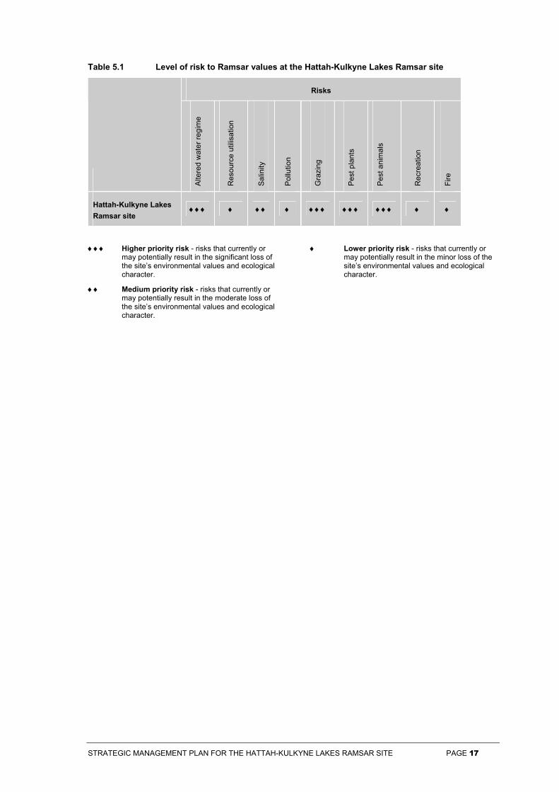
The main risks to the environmental values and ecological character of the Hattah-Kulkyne Lakes Ramsar site are summarised below in Table 5.1. It should be noted that the level of risk has not been assessed against the effort currently being applied to mitigating the risk.
Based on our current understanding altered water regimes, pest plants, pest animals and grazing are considered the most serious threat to the site’s environmental values and ecological character.
STRATEGIC MANAGEMENT PLAN FOR THE HATTAH-KULKYNE LAKES RAMSAR SITE PAGE 17
Table 5.1 Level of risk to Ramsar values at the Hattah-Kulkyne Lakes Ramsar site
Risks
Alte
red
wat
er re
gim
e
Res
ourc
e ut
ilisa
tion
Sal
inity
Pol
lutio
n
Gra
zing
Pes
t pla
nts
Pes
t ani
mal
s
Rec
reat
ion
Fire
Hattah-Kulkyne Lakes Ramsar site
♦♦♦ ♦ ♦♦ ♦ ♦♦♦ ♦♦♦ ♦♦♦ ♦ ♦
♦♦♦ Higher priority risk - risks that currently or may potentially result in the significant loss of the site’s environmental values and ecological character.
♦♦ Medium priority risk - risks that currently or may potentially result in the moderate loss of the site’s environmental values and ecological character.
♦ Lower priority risk - risks that currently or may potentially result in the minor loss of the site’s environmental values and ecological character.
STRATEGIC MANAGEMENT PLAN FOR THE HATTAH-KULKYNE LAKES RAMSAR SITE PAGE 18
6 Site Management Strategies
A number of Site Management Strategies have been developed in response to the analysis of risks to the values at the Hattah-Kulkyne Lakes Ramsar site. The Site Management Strategies are grouped under the relevant Management Objectives established by the Strategic Directions Statement.
The Site Management Strategies for the Hattah-Kulkyne Lakes Ramsar site promote a range of specific management actions that will maintain, and in some cases restore the ecological character of the site. The Site Management Strategies are designed to:
a) address risks that are having an adverse impact, or are likely to have an adverse impact on ecological character; and
b) highlight existing strategies and actions that are consistent with wise use principles.
The successful coordination and cooperation of the lead agencies, as well as the continued efforts of the many community and interest groups, is essential for the long-term conservation of the Hattah-Kulkyne Lakes Ramsar site. The Strategic Directions Statement, statutory mechanisms, management plans and management strategies will guide the implementation of this Strategic Management Plan.
DSE will have overall responsibility for:
• facilitating the implementation of the Strategic Directions Statement and Strategic Management Plans for Ramsar sites by ensuring relevant agencies incorporate relevant strategies into their work programs;
• coordinating and reporting on the progress and/or issues with implementation of the Strategic Directions Statement and Strategic Management Plans for Ramsar sites;
• ensuring monitoring programs are established in accordance with the Strategic Directions Statement and Strategic Management Plans for Ramsar sites;
• ensuring the regular review of Strategic Management Plans for Ramsar sites;
• preparing the Victorian chapter of Australia’s National Report to triennial Conferences of the Contracting Parties to the Ramsar Convention; and
• the six yearly update of the Ramsar Information Sheets for each site.
In order to clarify accountabilities, the lead agency responsible for the implementation of each strategy is identified. Lead agencies will monitor implementation of the strategies for which they are responsible. Lead agencies are encouraged to record progress on their responsibilities and extent of implementation and provide information in the form of annual summary reports to DSE. This information will be consistent with a format to be developed by DSE and will contribute to Victoria’s chapter in the National Report to the Convention on Wetlands, prepared every three years.
A rating of relative priority accompanies each Site Management Strategy. Definitions of these priorities are as follows:
Higher: Strategies that, when implemented, will significantly contribute to the maintenance of ecological character.
Medium: Strategies that, when implemented in conjunction with Higher priority strategies, will support the maintenance and contribute to the restoration of ecological character.
Lower: Strategies that, when implemented in conjunction with Higher and Medium priority strategies, will result in enhancement of ecological character.
STRATEGIC MANAGEMENT PLAN FOR THE HATTAH-KULKYNE LAKES RAMSAR SITE PAGE 19
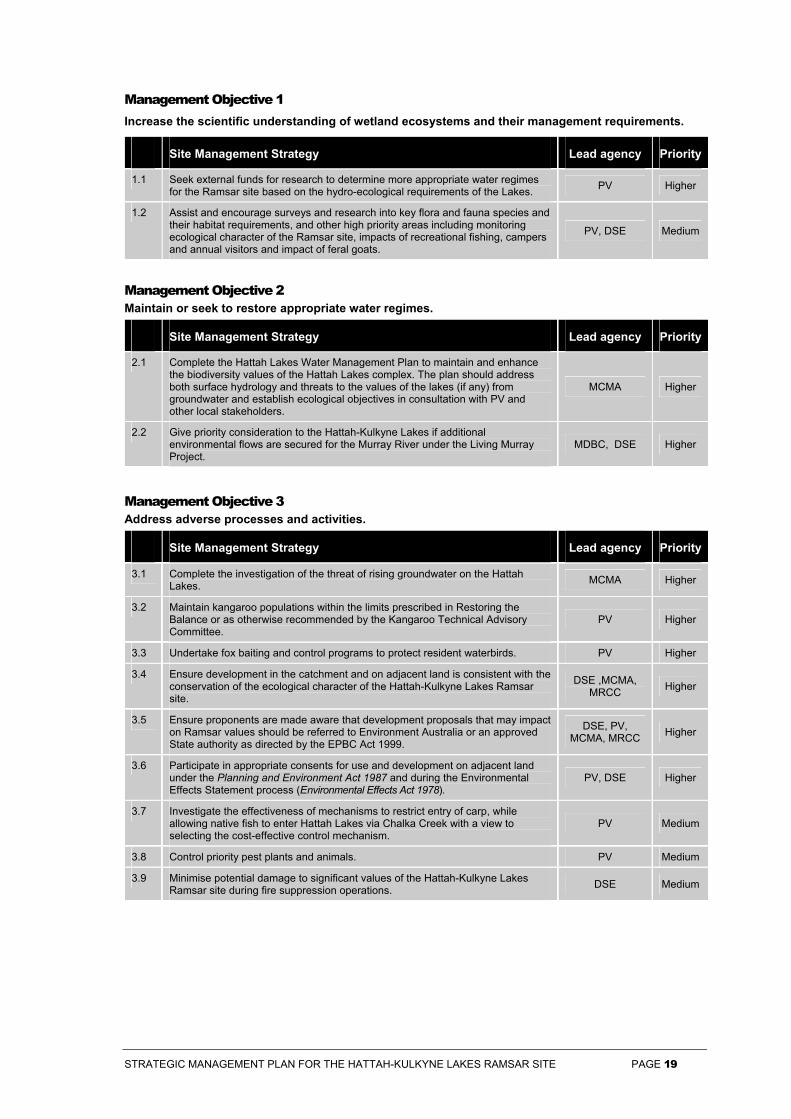
Management Objective 1 Increase the scientific understanding of wetland ecosystems and their management requirements.
Site Management Strategy Lead agency Priority
1.1 Seek external funds for research to determine more appropriate water regimes for the Ramsar site based on the hydro-ecological requirements of the Lakes. PV Higher
1.2 Assist and encourage surveys and research into key flora and fauna species and their habitat requirements, and other high priority areas including monitoring ecological character of the Ramsar site, impacts of recreational fishing, campers and annual visitors and impact of feral goats.
PV, DSE Medium
Management Objective 2 Maintain or seek to restore appropriate water regimes.
Site Management Strategy Lead agency Priority
2.1 Complete the Hattah Lakes Water Management Plan to maintain and enhance the biodiversity values of the Hattah Lakes complex. The plan should address both surface hydrology and threats to the values of the lakes (if any) from groundwater and establish ecological objectives in consultation with PV and other local stakeholders.
MCMA Higher
2.2 Give priority consideration to the Hattah-Kulkyne Lakes if additional environmental flows are secured for the Murray River under the Living Murray Project.
MDBC, DSE Higher
Management Objective 3 Address adverse processes and activities.
Site Management Strategy Lead agency Priority
3.1 Complete the investigation of the threat of rising groundwater on the Hattah Lakes. MCMA Higher
3.2 Maintain kangaroo populations within the limits prescribed in Restoring the Balance or as otherwise recommended by the Kangaroo Technical Advisory Committee.
PV Higher
3.3 Undertake fox baiting and control programs to protect resident waterbirds. PV Higher
3.4 Ensure development in the catchment and on adjacent land is consistent with the conservation of the ecological character of the Hattah-Kulkyne Lakes Ramsar site.
DSE ,MCMA, MRCC Higher
3.5 Ensure proponents are made aware that development proposals that may impact on Ramsar values should be referred to Environment Australia or an approved State authority as directed by the EPBC Act 1999.
DSE, PV, MCMA, MRCC Higher
3.6 Participate in appropriate consents for use and development on adjacent land under the Planning and Environment Act 1987 and during the Environmental Effects Statement process (Environmental Effects Act 1978).
PV, DSE Higher
3.7 Investigate the effectiveness of mechanisms to restrict entry of carp, while allowing native fish to enter Hattah Lakes via Chalka Creek with a view to selecting the cost-effective control mechanism.
PV Medium
3.8 Control priority pest plants and animals. PV Medium
3.9 Minimise potential damage to significant values of the Hattah-Kulkyne Lakes Ramsar site during fire suppression operations. DSE Medium
STRATEGIC MANAGEMENT PLAN FOR THE HATTAH-KULKYNE LAKES RAMSAR SITE PAGE 20
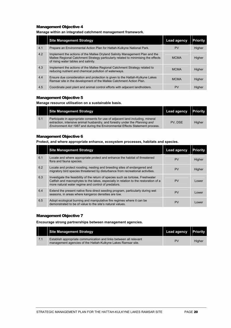
Management Objective 4 Manage within an integrated catchment management framework.
Site Management Strategy Lead agency Priority
4.1 Prepare an Environmental Action Plan for Hattah-Kulkyne National Park. PV Higher
4.2 Implement the actions of the Mallee Dryland Salinity Management Plan and the Mallee Regional Catchment Strategy particularly related to minimising the effects of rising water tables and salinity.
MCMA Higher
4.3 Implement the actions of the Mallee Regional Catchment Strategy related to reducing nutrient and chemical pollution of waterways. MCMA Higher
4.4 Ensure due consideration and protection is given to the Hattah-Kulkyne Lakes Ramsar site in the development of the Mallee Catchment Action Plan. MCMA Higher
4.5 Coordinate pest plant and animal control efforts with adjacent landholders. PV Higher
Management Objective 5 Manage resource utilisation on a sustainable basis.
Site Management Strategy Lead agency Priority
5.1 Participate in appropriate consents for use of adjacent land including, mineral extraction, intensive animal husbandry, and forestry under the Planning and Environment Act 1987 and during the Environmental Effects Statement process.
PV, DSE Higher
Management Objective 6 Protect, and where appropriate enhance, ecosystem processes, habitats and species.
Site Management Strategy Lead agency Priority
6.1 Locate and where appropriate protect and enhance the habitat of threatened flora and fauna species. PV Higher
6.2 Locate and protect roosting, nesting and breeding sites of endangered and migratory bird species threatened by disturbance from recreational activities. PV Higher
6.3 Investigate the feasibility of the return of species such as tortoise, Freshwater Catfish and macrophytes to the lakes, especially in relation to the restoration of a more natural water regime and control of predators.
PV Lower
6.4 Extend the present native flora direct seeding program, particularly during wet seasons, in areas where kangaroo densities are low. PV Lower
6.5 Adopt ecological burning and manipulative fire regimes where it can be demonstrated to be of value to the site’s natural values. PV Lower
Management Objective 7 Encourage strong partnerships between management agencies.
Site Management Strategy Lead agency Priority
7.1 Establish appropriate communication and links between all relevant management agencies of the Hattah-Kulkyne Lakes Ramsar site. PV Higher
STRATEGIC MANAGEMENT PLAN FOR THE HATTAH-KULKYNE LAKES RAMSAR SITE PAGE 21
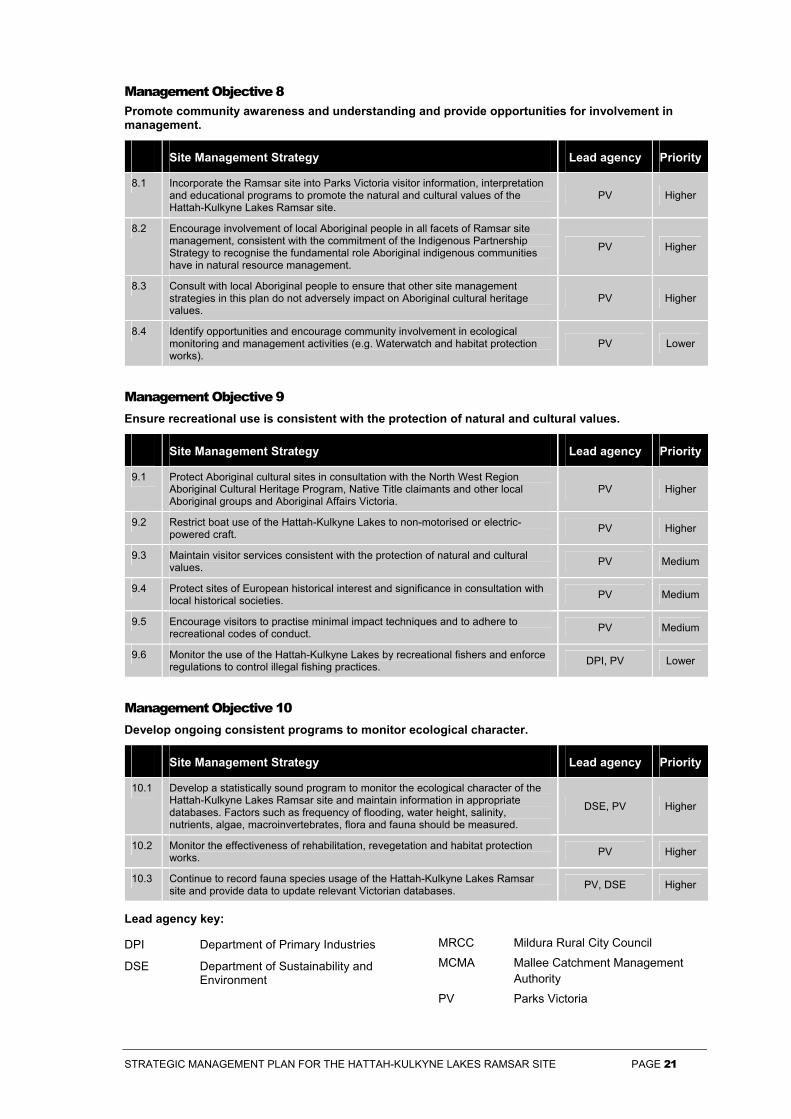
Management Objective 8 Promote community awareness and understanding and provide opportunities for involvement in management.
Site Management Strategy Lead agency Priority
8.1 Incorporate the Ramsar site into Parks Victoria visitor information, interpretation and educational programs to promote the natural and cultural values of the Hattah-Kulkyne Lakes Ramsar site.
PV Higher
8.2 Encourage involvement of local Aboriginal people in all facets of Ramsar site management, consistent with the commitment of the Indigenous Partnership Strategy to recognise the fundamental role Aboriginal indigenous communities have in natural resource management.
PV Higher
8.3 Consult with local Aboriginal people to ensure that other site management strategies in this plan do not adversely impact on Aboriginal cultural heritage values.
PV Higher
8.4 Identify opportunities and encourage community involvement in ecological monitoring and management activities (e.g. Waterwatch and habitat protection works).
PV Lower
Management Objective 9 Ensure recreational use is consistent with the protection of natural and cultural values.
Site Management Strategy Lead agency Priority
9.1 Protect Aboriginal cultural sites in consultation with the North West Region Aboriginal Cultural Heritage Program, Native Title claimants and other local Aboriginal groups and Aboriginal Affairs Victoria.
PV Higher
9.2 Restrict boat use of the Hattah-Kulkyne Lakes to non-motorised or electric-powered craft. PV Higher
9.3 Maintain visitor services consistent with the protection of natural and cultural values. PV Medium
9.4 Protect sites of European historical interest and significance in consultation with local historical societies. PV Medium
9.5 Encourage visitors to practise minimal impact techniques and to adhere to recreational codes of conduct. PV Medium
9.6 Monitor the use of the Hattah-Kulkyne Lakes by recreational fishers and enforce regulations to control illegal fishing practices. DPI, PV Lower
Management Objective 10 Develop ongoing consistent programs to monitor ecological character.
Site Management Strategy Lead agency Priority
10.1 Develop a statistically sound program to monitor the ecological character of the Hattah-Kulkyne Lakes Ramsar site and maintain information in appropriate databases. Factors such as frequency of flooding, water height, salinity, nutrients, algae, macroinvertebrates, flora and fauna should be measured.
DSE, PV Higher
10.2 Monitor the effectiveness of rehabilitation, revegetation and habitat protection works. PV Higher
10.3 Continue to record fauna species usage of the Hattah-Kulkyne Lakes Ramsar site and provide data to update relevant Victorian databases. PV, DSE Higher
Lead agency key:
DPI Department of Primary Industries
DSE Department of Sustainability and Environment
MRCC Mildura Rural City Council
MCMA Mallee Catchment Management Authority
PV Parks Victoria
STRATEGIC MANAGEMENT PLAN FOR THE HATTAH-KULKYNE LAKES RAMSAR SITE PAGE 22
References
Australia and New Zealand Environment and Conservation Council (1992) The Australian Water Quality Guidelines for Fresh and Marine Waters. National Water Quality Management Strategy, Australian and New Zealand Environment and Conservation Council.
Australian Nature Conservation Agency (1999) A Directory of important Wetlands in Australia. Australian Nature Conservation Agency, Canberra, ACT.
Cheal, D. C. (1993) Effects of stock grazing on the plants of semi-arid woodlands and grasslands. Proc. Roy. Soc. Vic. 105(1):57-65.
Cheal, D. C., Parkes, D., Parsons, R. F. and Sluiter, I. R. K. (1992) Vascular plants and communities. In: Endangered species and communities and threatening processes in Murray Mallee. Australian National Parks and Wildlife Service and the Murray-Darling Basin Commission, Canberra.
Cumming, P. L. F. and Lloyd, L. N. (1993) Flood Characteristics of the Hattah Lakes System. Integrated Watering Strategy Report No. 5. Department of Conservation and Environment, Victoria.
Department of Natural Resources and Environment (1996) Mallee Parks Management Plan. Department of Natural Resources and Environment, Victoria.
Department of Natural Resources and Environment (2001) Indigenous Partnerships Strategy. Department of Natural Resources and Environment, Victoria.
Department of Natural Resources and Environment (2002) Management of Victoria’s Ramsar Wetlands: Strategic Directions Statement. Department of Natural Resources and Environment, East Melbourne, Victoria.
Department of Sustainability and Environment (2003a) Atlas of Victorian Wildlife. Department of Sustainability and Environment, Victoria.
Department of Sustainability and Environment (2003b) Victorian Flora Information System. Department of Natural Resources and Environment, Victoria.
Environment Australia (2001) A Directory of Important Wetlands in Australia, Third Edition. Environment Australia, Canberra.
Environmental Protection Authority (1985) State Environment Protection Policy (Waters of Victoria). Policy No. S122. Environmental Protection Authority, Melbourne.
Mallee Catchment and Land Protection Board. (1997) Mallee Regional Catchment Strategy. Mallee Catchment and Land Protection Board, Victoria.
Mallee Catchment Management Authority (2001) Mallee Waterway and Floodplain Management Strategy, Mallee Catchment Management Authority, Victoria.
Mallee Catchment Management Authority (unpublished) Draft Final Hattah Lakes Water Management Plan, Mallee Catchment Management Authority, Victoria.
Mallee Dryland Community Working Group. (1993) Mallee Dryland Draft Salinity Management Plan. Mallee Dryland Community Working Group, Ouyen, Victoria.
Murray-Darling Basin Ministerial Commission (1989) Salinity and Drainage Strategy. Murray-Darling Basin Ministerial Commission, Canberra, ACT.
Murray-Darling Basin Ministerial Commission (1999) Salinity and Drainage Strategy: 10 Years On, 1999. Murray-Darling Basin Ministerial Commission, Canberra, ACT.
Ramsar Convention Bureau (1999) Wetland Risk Assessment. Seventh Meeting of the Conference of the Contracting Parties to the Convention on Wetlands (Ramsar, Iran, 1971), San José, Costa Rica. Ramsar Convention Bureau, Gland, Switzerland.
Read Sturgess and Associates (unpublished) Economic Assessment of Recreational Values of Victorian Parks. Report for the Department of Natural Resources and Environment, Victoria.
Sluiter, I. R. K., Allen, G. G., Morgan, D. G. and Walker, I. S. (1992). Kangaroo Management at Hattah-Kulkyne National Park: the vegetation response. Abstract Proceedings of the Fifth Australasian Wildlife Management Society, Brisbane 1992. Australasian Wildlife Management Society.
STRATEGIC MANAGEMENT PLAN FOR THE HATTAH-KULKYNE LAKES RAMSAR SITE PAGE 23
Sluiter, I.R.K., Allen, G.G., Morgan, D.G. and Walker, I.S. (1997) Vegetation Responses to Stratified Kangaroo Grazing Pressure at Hattah-Kulkyne National Park, 1992-1996. Flora and Fauna Technical Report No. 149. Department of Natural Resources and Environment and Parks Victoria, Victoria.
Souter, N.J. (1996) Time-Share Flooding of Aquatic Ecosystems - Strategy Assessment in Hattah Lakes (Vic) and Poon Boon Lakes (NSW) during 1994/95. Department of Natural Resources and Environment, Victoria.
United States Environment Protection Authority (1997) Draft Guidelines for Ecological Risk Assessment. United States Environment Protection Authority, Washington D.C., United States of America.
Water ECOscience Pty Ltd. (1996) State Water Quality Monitoring Annual Report: Victoria 1996 - Volume 1. Natural Resources and Environment, Victoria.
Westbrooke, M. E. (1990) Effects of activity on weediness in Mallee communities - studies at Mallee Cliffs National Park and Nanya Station, south western NSW. In: Juss, P. J. and Jones, G. K. (eds). The Mallee Lands: A Conservation Perspective. CSIRO, Melbourne, pp. 276-9.
STRATEGIC MANAGEMENT PLAN FOR THE HATTAH-KULKYNE LAKES RAMSAR SITE PAGE 24
Appendix 1 List of Contributors
Multi-disciplinary Project Team members
Simon Casanelia Conservation Officer, National Parks Policy and Strategy, Parks Victoria
Ben Churchill Team Leader Environment Strategy, National Parks and Conservation Policy, Parks Victoria
Ian Walker Environment Chief Ranger, West Region, Parks Victoria
Andrew Marshall Chief Ranger, Mallee District, Parks Victoria
Cheryl Wouters Environmental Program Manager, Mallee District, Parks Victoria
Phillip Murdoch Ranger in Charge, Hattah-Kulkyne National Park, Parks Victoria
Janet Holmes Senior Policy Officer, Parks, Flora and Fauna Division, DSE
Public Submissions
Australasian Wader Studies Group
Australian Defence Organisation
Bird Observers Club of Australia
Environment Australia (Wetlands Section)
Field and Game Australia Inc.
Mallee Catchment Management Authority
Peers, Monica
Phillips, Joan
Sunraysia Bird Observers’ Club
Victorian Farmers Association
VRFish Fish For The Future
STRATEGIC MANAGEMENT PLAN FOR THE HATTAH-KULKYNE LAKES RAMSAR SITE PAGE 25
Appendix 2 Resource List
Further reading
Atkins, B. (1993) The Integrated Watering Strategy for Mid-Murray Wetlands: Final Project Report. Department of Conservation and Natural Resources, Floodplain Ecology Group, Shepparton Victoria.
Beovich, E. K. (1993) Mallee Dryland Salinity Management Plan: Environmental Report. Department of Conservation and Natural Resources, Mildura, Victoria.
Department of Conservation and Environment (1990) Restoring the Balance: A Kangaroo Control Program for the Hattah-Kulkyne National Park. Department of Conservation and Environment, Victoria.
Department of Conservation, Forests and Lands (1988) Wetlands Conservation Program for Victoria. Department of Conservation, Forests and Lands, Victoria.
Department of Conservation and Natural Resources (1995) Establishment Report: Timeshare Flooding of Aquatic Ecosystems. Department of Conservation and Natural Resources, Floodplain Ecology Group, Shepparton, Victoria.
Department of Conservation and Natural Resources (1994) An Environmental Bulk Water Entitlement for the River Murray. Department of Conservation and Natural Resources, Floodplain Ecology Group, Melbourne, Victoria.
Department of Conservation and Natural Resources (1992) Mildura Region Fire Protection Plan. Department of Conservation and Natural Resources, Mildura, Victoria.
Department of Natural Resources and Environment (2002) Healthy Rivers, Healthy Communities and Regional Growth: Victorian River Health Strategy. Department of Natural Resources and Environment, Victoria.
Department of Natural Resources and Environment (2001) Indigenous Partnerships Strategy. Department of Natural Resources and Environment, Victoria.
Department of Natural Resources and Environment (1997) Victoria’s Biodiversity: Directions in Management, Department of Natural Resources and Environment, Melbourne.
Emison, W. B., Beardsell, C. M., Norman, F. I., and Loyn, R. H. (1987) Atlas of Australian Birds. Department of Conservation, Forests and Lands, and the Royal Australasian Ornithologists Union, Melbourne.
Environment Protection Authority (2001) Draft State Environmental Protection Policy (Waters of Victoria): Our Water, Our Future, Environment Protection Authority, Southbank, Victoria.
Landcare Victoria (1993) Mallee Regional Landcare Plan. Landcare Victoria, Mildura, Victoria.
Land Conservation Council (1989) Mallee Area Review Final Recommendations. Land Conservation Council. Melbourne.
Long, A. and Edmond, V. (1997) Hattah-Kulkyne National Park and Murray Kulkyne Park Aboriginal Heritage Review. Volume 2: Cultural Heritage Management. A Report to Aboriginal Affairs Victoria, Melbourne.
Mallee Catchment Management Authority (2002) Draft Mallee Regional Catchment Strategy. Mallee Catchment Management Authority, Mildura, Victoria.
Mallee Catchment Management Authority (2002) Murray River Frontage Action Plan: Robinvale to Merbein. Mallee Catchment Management Authority, Mildura, Victoria.
Mallee Catchment Management Authority (2000) Mallee Waterway and Floodplain Management Strategies. Mallee Catchment Management Authority, Mildura, Victoria.
Morgan, D. G. (2001) Kangaroo Populations, December 2000. Report to Parks Victoria. Hattah-Kulkyne National Park and Murray Kulkyne Park. Department of Zoology, University of Melbourne, Melbourne.
Murray-Darling Basin Ministerial Council (2002) The Living Murray: A Discussion Paper on Restoring the Health of the Murray River. Murray Darling Ministerial Council, Canberra, ACT.
Murray-Darling Basin Ministerial Council (1999) The Salinity Audit of the Murray-Darling Basin. A 100-year Perspective. Murray Darling Ministerial Council, Canberra.
STRATEGIC MANAGEMENT PLAN FOR THE HATTAH-KULKYNE LAKES RAMSAR SITE PAGE 26
Ramsar Convention Bureau. (1997). The Ramsar Convention Manual: A Guide to the Convention on Wetlands (Ramsar, Iran, 1971), 2nd edn. Ramsar Convention Bureau, Gland, Switzerland.
Contacts for further information and collaboration
Mallee Catchment Management Authority
Wimmera Catchment Management Authority
Mildura Rural City Council
Yarriambiack Shire Council
Parks Victoria
Department of Sustainability and Environment Mildura Office
Related websites
www.ramsar.org
www.ea.gov.au
www.dse.vic.gov.au
www.parkweb.vic.gov.au
www.malleecma.vic.gov.au
www.birdsaustralia.com.au
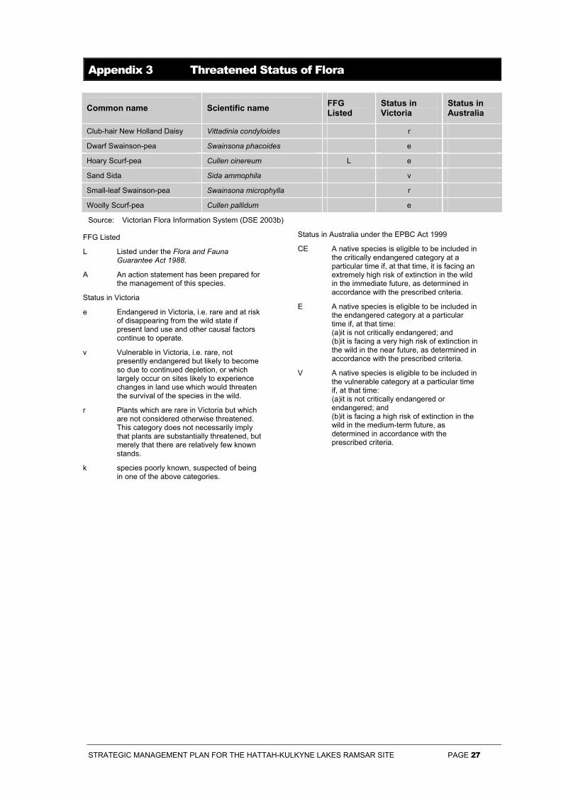
STRATEGIC MANAGEMENT PLAN FOR THE HATTAH-KULKYNE LAKES RAMSAR SITE PAGE 27
Appendix 3 Threatened Status of Flora
Common name Scientific name FFG Listed
Status in Victoria
Status in Australia
Club-hair New Holland Daisy Vittadinia condyloides r
Dwarf Swainson-pea Swainsona phacoides e
Hoary Scurf-pea Cullen cinereum L e
Sand Sida Sida ammophila v
Small-leaf Swainson-pea Swainsona microphylla r
Woolly Scurf-pea Cullen pallidum e
Source: Victorian Flora Information System (DSE 2003b)
FFG Listed
L Listed under the Flora and Fauna Guarantee Act 1988.
A An action statement has been prepared for the management of this species.
Status in Victoria
e Endangered in Victoria, i.e. rare and at risk of disappearing from the wild state if present land use and other causal factors continue to operate.
v Vulnerable in Victoria, i.e. rare, not presently endangered but likely to become so due to continued depletion, or which largely occur on sites likely to experience changes in land use which would threaten the survival of the species in the wild.
r Plants which are rare in Victoria but which are not considered otherwise threatened. This category does not necessarily imply that plants are substantially threatened, but merely that there are relatively few known stands.
k species poorly known, suspected of being in one of the above categories.
Status in Australia under the EPBC Act 1999
CE A native species is eligible to be included in the critically endangered category at a particular time if, at that time, it is facing an extremely high risk of extinction in the wild in the immediate future, as determined in accordance with the prescribed criteria.
E A native species is eligible to be included in the endangered category at a particular time if, at that time: (a)it is not critically endangered; and (b)it is facing a very high risk of extinction in the wild in the near future, as determined in accordance with the prescribed criteria.
V A native species is eligible to be included in the vulnerable category at a particular time if, at that time: (a)it is not critically endangered or endangered; and (b)it is facing a high risk of extinction in the wild in the medium-term future, as determined in accordance with the prescribed criteria.
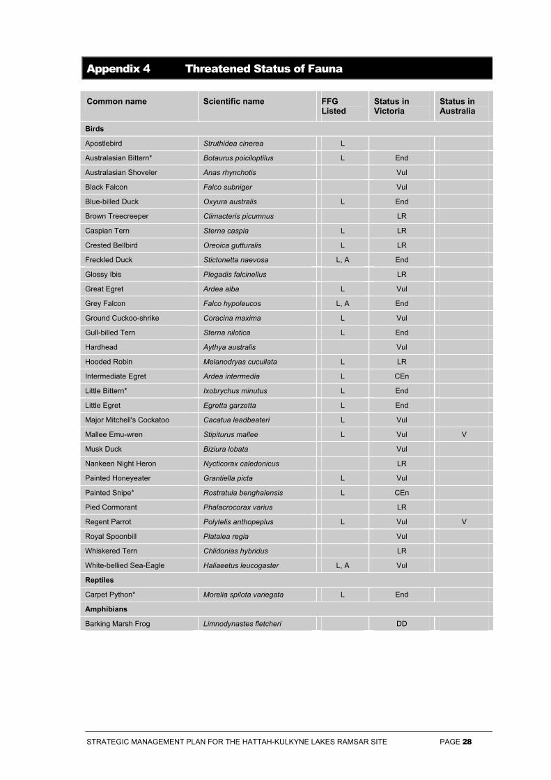
STRATEGIC MANAGEMENT PLAN FOR THE HATTAH-KULKYNE LAKES RAMSAR SITE PAGE 28
Appendix 4 Threatened Status of Fauna
Common name Scientific name FFG Listed
Status in Victoria
Status in Australia
Birds
Apostlebird Struthidea cinerea L
Australasian Bittern* Botaurus poiciloptilus L End
Australasian Shoveler Anas rhynchotis Vul
Black Falcon Falco subniger Vul
Blue-billed Duck Oxyura australis L End
Brown Treecreeper Climacteris picumnus LR
Caspian Tern Sterna caspia L LR
Crested Bellbird Oreoica gutturalis L LR
Freckled Duck Stictonetta naevosa L, A End
Glossy Ibis Plegadis falcinellus LR
Great Egret Ardea alba L Vul
Grey Falcon Falco hypoleucos L, A End
Ground Cuckoo-shrike Coracina maxima L Vul
Gull-billed Tern Sterna nilotica L End
Hardhead Aythya australis Vul
Hooded Robin Melanodryas cucullata L LR
Intermediate Egret Ardea intermedia L CEn
Little Bittern* Ixobrychus minutus L End
Little Egret Egretta garzetta L End
Major Mitchell's Cockatoo Cacatua leadbeateri L Vul
Mallee Emu-wren Stipiturus mallee L Vul V
Musk Duck Biziura lobata Vul
Nankeen Night Heron Nycticorax caledonicus LR
Painted Honeyeater Grantiella picta L Vul
Painted Snipe* Rostratula benghalensis L CEn
Pied Cormorant Phalacrocorax varius LR
Regent Parrot Polytelis anthopeplus L Vul V
Royal Spoonbill Platalea regia Vul
Whiskered Tern Chlidonias hybridus LR
White-bellied Sea-Eagle Haliaeetus leucogaster L, A Vul
Reptiles
Carpet Python* Morelia spilota variegata L End
Amphibians
Barking Marsh Frog Limnodynastes fletcheri DD
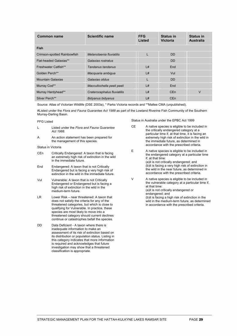
STRATEGIC MANAGEMENT PLAN FOR THE HATTAH-KULKYNE LAKES RAMSAR SITE PAGE 29
Common name Scientific name FFG Listed
Status in Victoria
Status in Australia
Fish
Crimson-spotted Rainbowfish Melanotaenia fluviatilis L DD
Flat-headed Galaxias** Galaxias rostratus DD
Freshwater Catfish** Tandanus tandanus L# End
Golden Perch** Macquaria ambigua L# Vul
Mountain Galaxias Galaxias olidus L DD
Murray Cod** Maccullochella peeli peeli L# End
Murray Hardyhead** Craterocephalus fluviatilis L# CEn V
Silver Perch** Bidyanus bidyanus L# CEn
Source: Atlas of Victorian Wildlife (DSE 2003a), * Parks Victoria records and **Mallee CMA (unpublished).
#Listed under the Flora and Fauna Guarantee Act 1988 as part of the Lowland Riverine Fish Community of the Southern Murray-Darling Basin.
FFG Listed
L Listed under the Flora and Fauna Guarantee Act 1988.
A An action statement has been prepared for the management of this species.
Status in Victoria
CEn Critically Endangered: A taxon that is facing an extremely high risk of extinction in the wild in the immediate future.
End Endangered: A taxon that is not Critically Endangered but is facing a very high risk of extinction in the wild in the immediate future.
Vul Vulnerable: A taxon that is not Critically Endangered or Endangered but is facing a high risk of extinction in the wild in the medium-term future.
LR Lower Risk – near threatened: A taxon that does not satisfy the criteria for any of the threatened categories, but which is close to qualifying for Vulnerable. In practice, these species are most likely to move into a threatened category should current declines continue or catastrophes befall the species.
DD Data Deficient - A taxon where there is inadequate information to make an assessment of its risk of extinction based on its distribution or population status. Listing in this category indicates that more information is required and acknowledges that future investigation may show that a threatened classification is appropriate.
Status in Australia under the EPBC Act 1999
CE A native species is eligible to be included in the critically endangered category at a particular time if, at that time, it is facing an extremely high risk of extinction in the wild in the immediate future, as determined in accordance with the prescribed criteria.
E A native species is eligible to be included in the endangered category at a particular time if, at that time: (a)it is not critically endangered; and (b)it is facing a very high risk of extinction in the wild in the near future, as determined in accordance with the prescribed criteria.
V A native species is eligible to be included in the vulnerable category at a particular time if, at that time: (a)it is not critically endangered or endangered; and (b)it is facing a high risk of extinction in the wild in the medium-term future, as determined in accordance with the prescribed criteria.
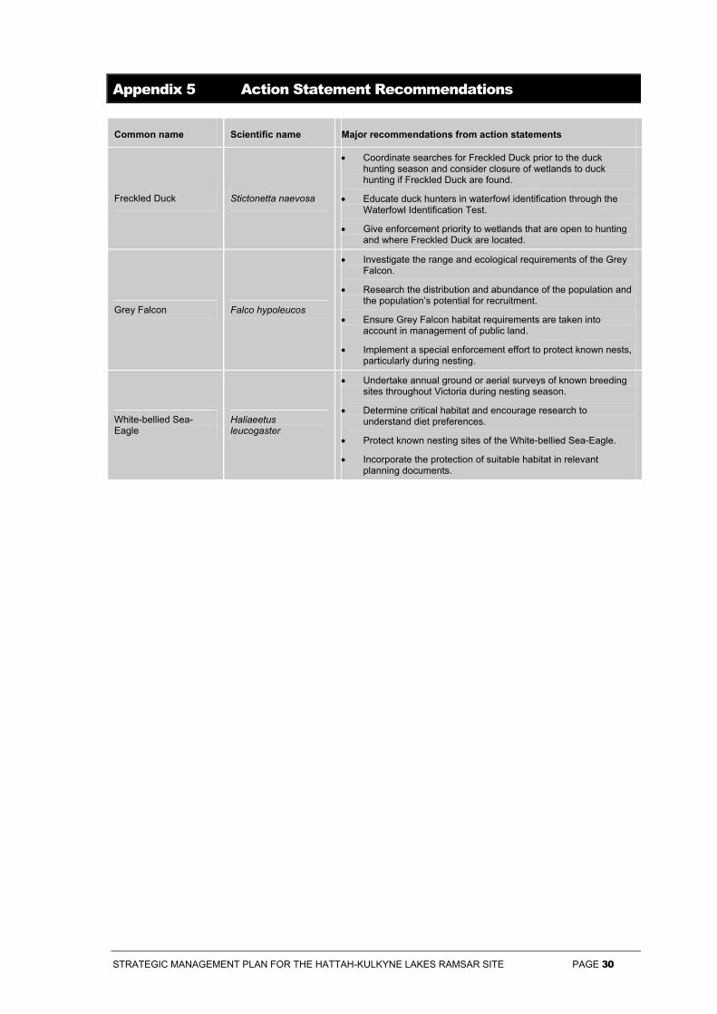
STRATEGIC MANAGEMENT PLAN FOR THE HATTAH-KULKYNE LAKES RAMSAR SITE PAGE 30
Appendix 5 Action Statement Recommendations
Common name Scientific name Major recommendations from action statements
Freckled Duck Stictonetta naevosa
• Coordinate searches for Freckled Duck prior to the duck hunting season and consider closure of wetlands to duck hunting if Freckled Duck are found.
• Educate duck hunters in waterfowl identification through the Waterfowl Identification Test.
• Give enforcement priority to wetlands that are open to hunting and where Freckled Duck are located.
Grey Falcon Falco hypoleucos
• Investigate the range and ecological requirements of the Grey Falcon.
• Research the distribution and abundance of the population and the population’s potential for recruitment.
• Ensure Grey Falcon habitat requirements are taken into account in management of public land.
• Implement a special enforcement effort to protect known nests, particularly during nesting.
White-bellied Sea-Eagle
Haliaeetus leucogaster
• Undertake annual ground or aerial surveys of known breeding sites throughout Victoria during nesting season.
• Determine critical habitat and encourage research to understand diet preferences.
• Protect known nesting sites of the White-bellied Sea-Eagle.
• Incorporate the protection of suitable habitat in relevant planning documents.
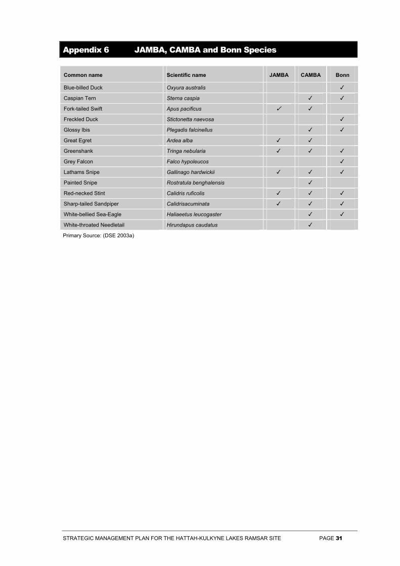
STRATEGIC MANAGEMENT PLAN FOR THE HATTAH-KULKYNE LAKES RAMSAR SITE PAGE 31
Appendix 6 JAMBA, CAMBA and Bonn Species
Common name Scientific name JAMBA CAMBA Bonn
Blue-billed Duck Oxyura australis
Caspian Tern Sterna caspia
Fork-tailed Swift Apus pacificus
Freckled Duck Stictonetta naevosa
Glossy Ibis Plegadis falcinellus
Great Egret Ardea alba
Greenshank Tringa nebularia
Grey Falcon Falco hypoleucos
Lathams Snipe Gallinago hardwickii
Painted Snipe Rostratula benghalensis
Red-necked Stint Calidris ruficolis
Sharp-tailed Sandpiper Calidrisacuminata
White-bellied Sea-Eagle Haliaeetus leucogaster
White-throated Needletail Hirundapus caudatus
Primary Source: (DSE 2003a)
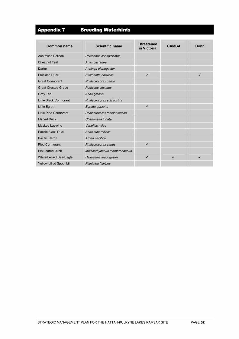
STRATEGIC MANAGEMENT PLAN FOR THE HATTAH-KULKYNE LAKES RAMSAR SITE PAGE 32
Appendix 7 Breeding Waterbirds
Common name Scientific name Threatened in Victoria CAMBA Bonn
Australian Pelican Pelecanus conspicillatus
Chestnut Teal Anas castanea
Darter Anhinga elanogaster
Freckled Duck Stictonetta naevosa
Great Cormorant Phalacrocorax carbo
Great Crested Grebe Podiceps cristatus
Grey Teal Anas gracilis
Little Black Cormorant Phalacrocorax sulcirostris
Little Egret Egretta garzetta
Little Pied Cormorant Phalacrocorax melanoleucos
Maned Duck Chenonetta jubata
Masked Lapwing Vanellus miles
Pacific Black Duck Anas superciliosa
Pacific Heron Ardea pacifica
Pied Cormorant Phalacrocorax varius
Pink-eared Duck Malacorhynchus membranaceus
White-bellied Sea-Eagle Haliaeetus leucogaster
Yellow-billed Spoonbill Plantalea flavipes
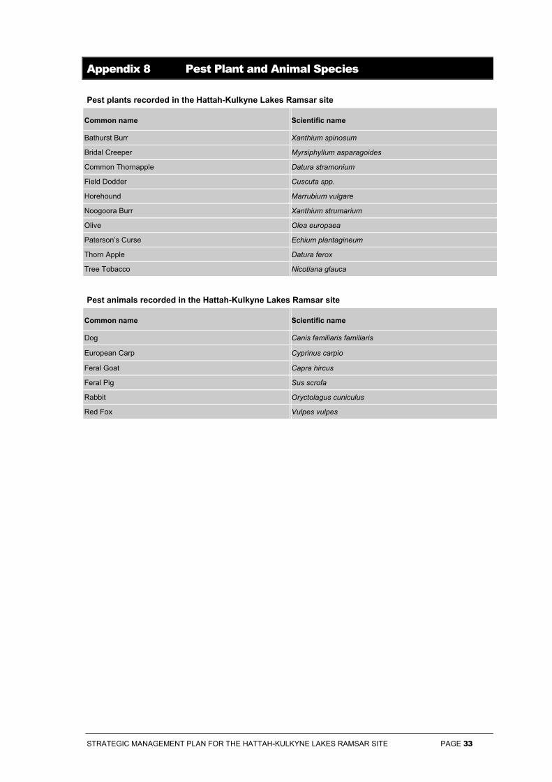
STRATEGIC MANAGEMENT PLAN FOR THE HATTAH-KULKYNE LAKES RAMSAR SITE PAGE 33
Appendix 8 Pest Plant and Animal Species
Pest plants recorded in the Hattah-Kulkyne Lakes Ramsar site
Common name Scientific name
Bathurst Burr Xanthium spinosum
Bridal Creeper Myrsiphyllum asparagoides
Common Thornapple Datura stramonium
Field Dodder Cuscuta spp.
Horehound Marrubium vulgare
Noogoora Burr Xanthium strumarium
Olive Olea europaea
Paterson’s Curse Echium plantagineum
Thorn Apple Datura ferox
Tree Tobacco Nicotiana glauca
Pest animals recorded in the Hattah-Kulkyne Lakes Ramsar site
Common name Scientific name
Dog Canis familiaris familiaris
European Carp Cyprinus carpio
Feral Goat Capra hircus
Feral Pig Sus scrofa
Rabbit Oryctolagus cuniculus
Red Fox Vulpes vulpes
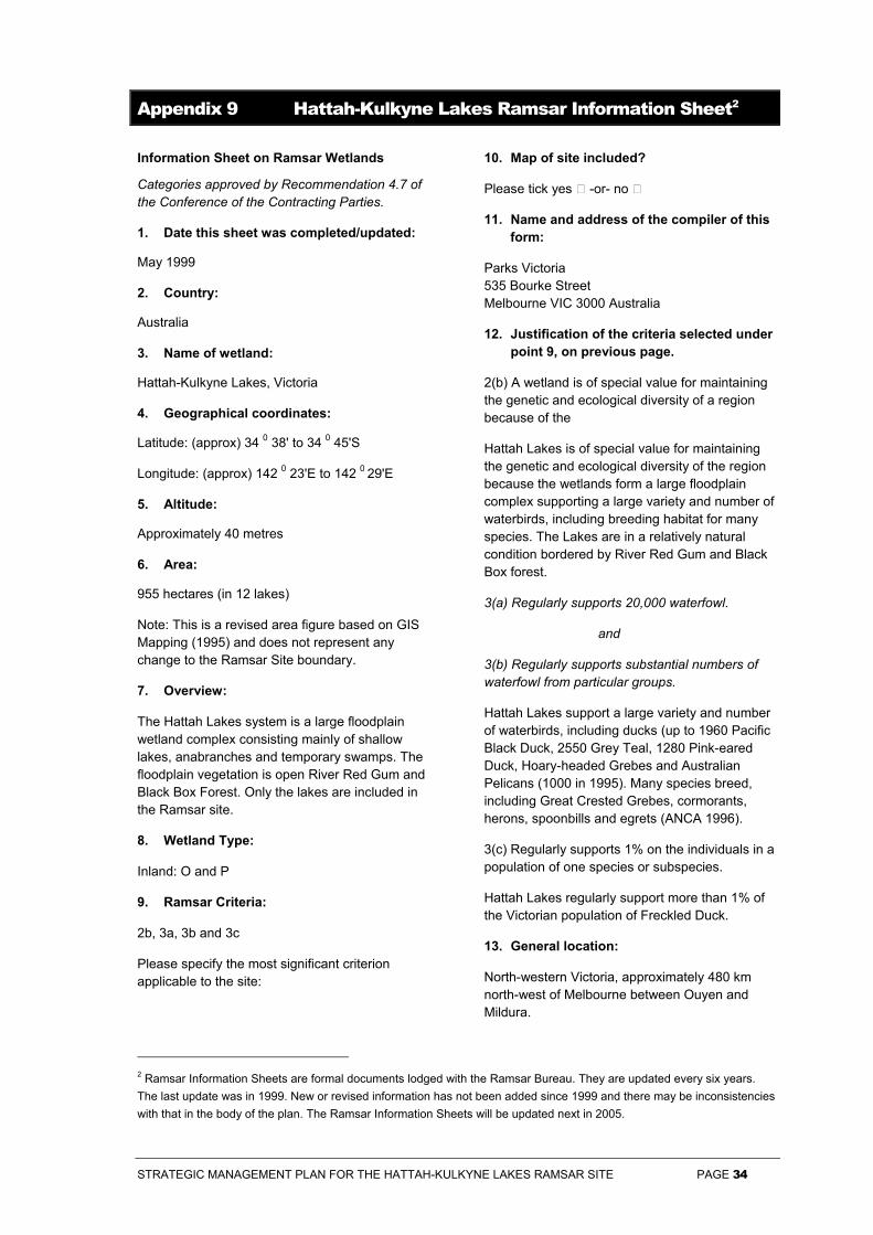
STRATEGIC MANAGEMENT PLAN FOR THE HATTAH-KULKYNE LAKES RAMSAR SITE PAGE 34
Appendix 9 Hattah-Kulkyne Lakes Ramsar Information Sheet2
2 Ramsar Information Sheets are formal documents lodged with the Ramsar Bureau. They are updated every six years. The last update was in 1999. New or revised information has not been added since 1999 and there may be inconsistencies with that in the body of the plan. The Ramsar Information Sheets will be updated next in 2005.
Information Sheet on Ramsar Wetlands
Categories approved by Recommendation 4.7 of the Conference of the Contracting Parties.
1. Date this sheet was completed/updated:
May 1999
2. Country:
Australia
3. Name of wetland:
Hattah-Kulkyne Lakes, Victoria
4. Geographical coordinates:
Latitude: (approx) 34 0 38' to 34 0 45'S
Longitude: (approx) 142 0 23'E to 142 0 29'E
5. Altitude:
Approximately 40 metres
6. Area:
955 hectares (in 12 lakes)
Note: This is a revised area figure based on GIS Mapping (1995) and does not represent any change to the Ramsar Site boundary.
7. Overview:
The Hattah Lakes system is a large floodplain wetland complex consisting mainly of shallow lakes, anabranches and temporary swamps. The floodplain vegetation is open River Red Gum and Black Box Forest. Only the lakes are included in the Ramsar site.
8. Wetland Type:
Inland: O and P
9. Ramsar Criteria:
2b, 3a, 3b and 3c
Please specify the most significant criterion applicable to the site:
10. Map of site included?
Please tick yes -or- no
11. Name and address of the compiler of this form:
Parks Victoria 535 Bourke Street Melbourne VIC 3000 Australia
12. Justification of the criteria selected under point 9, on previous page.
2(b) A wetland is of special value for maintaining the genetic and ecological diversity of a region because of the
Hattah Lakes is of special value for maintaining the genetic and ecological diversity of the region because the wetlands form a large floodplain complex supporting a large variety and number of waterbirds, including breeding habitat for many species. The Lakes are in a relatively natural condition bordered by River Red Gum and Black Box forest.
3(a) Regularly supports 20,000 waterfowl.
and
3(b) Regularly supports substantial numbers of waterfowl from particular groups.
Hattah Lakes support a large variety and number of waterbirds, including ducks (up to 1960 Pacific Black Duck, 2550 Grey Teal, 1280 Pink-eared Duck, Hoary-headed Grebes and Australian Pelicans (1000 in 1995). Many species breed, including Great Crested Grebes, cormorants, herons, spoonbills and egrets (ANCA 1996).
3(c) Regularly supports 1% on the individuals in a population of one species or subspecies.
Hattah Lakes regularly support more than 1% of the Victorian population of Freckled Duck.
13. General location:
North-western Victoria, approximately 480 km north-west of Melbourne between Ouyen and Mildura.
STRATEGIC MANAGEMENT PLAN FOR THE HATTAH-KULKYNE LAKES RAMSAR SITE PAGE 35
14. Physical features:
The Hattah Lakes System forms part of the Murray River floodplain. The floodplain is covered by grey heavy clays on Quaternary alluvium. Pervious, non-cohesive red aeolian sand rests on this clay layer, with white aeolian river sand forming low ridges between individual lakes.
The climate of the Hattah Lakes area and north-western Victoria in general, is semi-arid. The annual rainfall averages about 250mm, with October usually the wettest month.
The main hydro-ecological feature of the Hattah complex is the large variation in permanency of the aquatic habitats ranging from episodically flooded lakes to almost permanent lakes which receive regular inflows.
The Hattah Lakes System is filled via Chalka Creek, an anabranch of the River Murray. The overall sequence of events during floods is complex, with the filling and emptying of each lake depending on its position in the system, its area, and its depth. The first lake to receive flood waters, several days after they first enter Chalka Creek, is Lake Lockie. All the southern lakes are then filled from Lake Lockie, typically taking another three weeks for water to reach the furthest lakes. The northern part of the system, Lakes Mournpall, Yerang, Yelwell and Konardin, receives water both directly from Chalka Creek, and via Lake Lockie. Lake Bitterang is the last of the lakes to fill, with flood waters only reaching it over a month after the beginning of flooding, and then only if the flood level is sufficiently high. When the lakes are full, floodwaters also spread over surrounding flooplains, including an area of sand dunes and Black Box flats to the west and south-west of Lake Lockie.
Water retained in lake basins once floodwaters recede is gradually lost through evaporation. Most lakes are shallow, and dry up within two years if not refilled, but Lake Hattah may retain water for three years, and Lake Mournpall for up to seven years.
15. Hydrological values:
Two of the lakes, Mournpall and Hattah, are semi-permanent, retaining water for periods of seven and three years respectively. Lake Hattah is used as a water supply for the residents of Hattah. This lake is not required as a water supply for Hattah residents due to the installation of a pipeline to the Murray River. The lake could still be used in an emergency situation
There are three structures which can be managed
to achieve minor effects on the hydrology of the Hattah Lakes system.
A concrete causeway with 3 box culverts and 3 screw-gates near the offtake of the southern arm of Chalka Creek from the Murray. This is opened to allow the entry of high flows from the river and can be closed to pool water in the creek channel. This regulator also initially maintains a higher pool in Lake s. Although I believe only a matter of 10-20 centimetres (P.Murdoch pers. comm.)
A regulator consisting of a concrete structure into which drop bars can be placed, situated at the entry of Chalka Creek into Lake Lockie. This regulator has been decommissioned due to siltation and natural realignment of water flow
A drop bar regulator between Lake Hattah and Little Lake Hattah. Decommissioned 1994
16. Ecological features:
Hattah-Kulkyne National Park supports an open woodland dominated by Red Gum and Black Box which extends into the lake margins. Tangled Lignum forms shrubby stands around some lakes.
After flood periods this system of lakes becomes a large breeding area for waterfowl, including herons, egrets, cormorants and spoonbills.
17. Noteworthy flora:
Of considerable significance at a Victorian level are remnant stands of Slender Cypress Pine, Belah, and Buloke.
Threatened Species
Endangered in Victoria:
• Cullen pallidum (Wooly Scruf-pea)
• Cyperus nervulosus (Annual Flat-sedge)
• Cyperus rigidellus (Dwarf Flat-sedge)
• Glycine canescens (Silky Glycine)
• Lepidium monoplocoides (Winged Pepper-cress)
Endangered Australia-wide:
• Psoralea cinerea (Hoary Psoralea)
• Psoralea tenax (Tough Psoralea)
• Scaevola depauperata (Skeleton Fan-flower)
• Swainsona phacoides (Dwarf Swainson-pea)
Vulnerable in Victoria:
• Comesperma scoparium (Broom Milkwort)
STRATEGIC MANAGEMENT PLAN FOR THE HATTAH-KULKYNE LAKES RAMSAR SITE PAGE 36
• Cyperus squamosus (Bearded Flat-sedge)
• Drosera indica (Indian Sundew)
• Olearia subspicata (Spiked Daisy-bush)
• Phyllanthus lacunarius (Lagoon Spurge)
• Radyera farragei (Desert Rose Mallow)
• Sida ammophila (Sand Sida)
• Swainsona laxa (Yellow Swainson-pea) [Vulnerable Australia-wide]
Rare in Victoria:
• Callistemon brachyandrus (Prickly Bottlebrush)
• Calstemma purpureum (Garland Lily)
• Cymbonotus lawsonianus (Bear's Ears)
• Frankenia crispa (Hoary Sea-heath)
• Sclerostegia moniliformis (Ruby Glasswort)
• Velleia arguta (Grassland Velleia)
• Vittadinia condyloides (Club-hair New Holland Daisy)
Depleted in Victoria:
• Alectryon oleifolius (Cattle Bush)
18. Noteworthy fauna:
12 species of waterbird - the following lists cover species found in the National Park are covered by the Japan-Australia Migratory Birds Agreement, the China-Australia Migratory Birds Agreement or both. These include:
• Great Egret (Egretta alba) JAMBA, CAMBA
• Red-necked Stint (Calidris ruficolis) JAMBA, CAMBA
• Sharp-tailed Sandpiper (Calidris acuminata) JAMBA, CAMBA
• Greenshank (Tringa nebularia) JAMBA, CAMBA
• Latham's Snipe (Gallinago hardwickii) JAMBA, CAMBA
• Glossy Ibis (Plegadis falcinellus) CAMBA
• White-bellied Sea-Eagle (Haliaeetus leucogaster) CAMBA
• Painted Snipe (Rostratula benghalensis) CAMBA
• White-throated Needletail (Hirundapus caudatus) CAMBA
• Fork-tailed Swift (Apus pacificus) CAMBA
• Caspian Tern (Hydroprogne caspia) CAMBA
Threatened Birds
Vulnerable in Victoria:
• Grey Falcon (Falco hypoleucos)
• Major Mitchell’s Cockatoo (Cacatua leadbeateri)
• Regent Parrot (Polytelis anthopeplus)
• Malle Emu-wren (Stipiturus mallee)
Rare in Victoria:
• Little Bittern (Ixobrychus minutus)
• Freckled Duck (Stictonetta naevosa)
Lake Arawak - 14 (1983)
Lake Bitterang - 101 (1983)
Lake Bulla - 27 (1983)
Lake Hattah - 26 (1983)
Lake Konardin - 65 (1983)
Lake Kramen - 82 (1983)
Lake Mournpall - 16 (1983), 2 (6/2/88 - 88 counted for the whole of Victoria)
Lake Yelwell - 8 (1987 - 261 counted for the whole of Victoria)
• Blue-billed Duck (Oxyura australis)
• White-bellied Sea-Eagle (Haliaeetus leucogaster)
• Brolga (Grus rubundicus)
• Apostlebird (Struthidea cinerea)
Indeterminate (known to be Rare, Vulnerable or Endangered) in Victoria:
• Painted Snipe (Rostratula benghalensis)
• Painted Honeyeater (Grantiella picta)
Insufficiently Known (suspected Rare, Vulnerable or Endangered) in Victoria:
• Australasian Bittern (Botaurus poiciloptilus)
Restricted colonial breeding sites in Victoria:
• Darter (Anhinga melanogaster)
• Great Egret (Ardea alba)
• Australian Pelican (Pelecanus conspicallatus) - bred on Lakes Mournpall and Lockie in 1977-78 (11 nests)
STRATEGIC MANAGEMENT PLAN FOR THE HATTAH-KULKYNE LAKES RAMSAR SITE PAGE 37
Threatened Mammals
Rare in Victoria:
• Common Dunnart (Sminthopsis murina)
• Mitchell's Hopping Mouse (Notomys mitchelli)
• Greater Long-eared Bat (Nyctophilus timoriensis)
Threatened Amphibians
Insufficiently Known (suspected Rare, Vulnerable or Endangered) in Victoria:
• Barking Marsh Frog (Limnodynastes fletcheri)
Threatened Reptiles
Endangered in Victoria:
• Beaked Gecko (Rhyncoedura ornata)
Vulnerable in Victoria:
• Carpet Python (Morelia spilota variegata)
Insufficiently Known (suspected Rare, Vulnerable or Endangered) in Victoria
• Tree Goanna (Varanus varius)
• Broad-shelled River Tortoise (Chelodina expansa)
Threatened Fish
Vulnerable in Victoria:
• Silver Perch (Bidyanus bidyanus)
• Murray Cod (Maccullochella peeli)
• Catfish (Tandanus tandanus)
Rare in Victoria:
• Golden Perch (Macquaria ambigua)
• Bony Bream (Nematolosa erebi)
• Murray Hardyhead (Craterocephalus fluviatilis)
Indeterminate (known to be Rare, Vulnerable or Endangered) in Victoria:
• Flat-headed Galaxias (Galaxius rostratus)
• Freshwater Hardyhead (Craterocephalus stercusmuscarum)
19. Social and cultural values:
A recent survey by the Victorian Archaeological Society covered less than 3% of the Hattah-Kulkyne and Murray-Kulkyne National Parks, yet located over 900 archaeological sites, almost all of which date to the prehistoric Aboriginal
occupation of the area.
20. Land tenure/ownership:
The lakes are within the Hattah-Kulkyne National Park, managed by Parks Victoria .
21. Current land use:
• Conservation
• Recreation
22. Factors (past, present or potential) adversely affecting the site's ecological character, including changes in land use and development projects:
There has been no significant change in ecological character since the Ramsar information sheet was last undated in 1992.
A channel between Lake Lockie and Lake Hattah was constructed in 1908 for the purpose of increasing flows between the two lakes. However it had the effect of reducing the retention level of Lake Hattah by 0.38m. Consequently, the lake may now dry sooner to the detriment of aquatic organisms and may have induced Red Gums to have regenerated at the lower retention level.
The flooding frequency in this system of lakes has been reduced by regulation on the Murray River for irrigation supplies. The impacts of reduced flooding frequency include some death and loss of vigour of riparian Red Gums, alteration of tree distributions, and reduced flooding with consequent loss of breeding opportunity for waterbirds and fish.
Toxic algal blooms also occur in the lakes, apparently after they are recharged with water from the Murray River.
23. Conservation measures taken:
• Reservation of the lakes as part of the Hattah-Kulkyne National Park under the National Parks Act 1975 (Vic) provides a legislative basis for the protection of their natural values.
• The values of the Hattah-Kulkyne Lakes have been recognised by listing on the Register of the National Estate.
• The Mallee Parks Management Plan 1996 sets out strategies for management of the lakes, including restoring a more natural water regime and managing algal blooms.
• The Integrated Strategy for Murray Wetlands (1991) sets out initiatives to restore a more natural flood regime to the Hattah Lakes.
STRATEGIC MANAGEMENT PLAN FOR THE HATTAH-KULKYNE LAKES RAMSAR SITE PAGE 38
• A Timeshare Flooding Project has been completed to test the robustness of the wetland ecosystems under different water regimes. The project findings will be used as the basis for developing models to supply environmental water.
• Work on the impacts of grazing by kangaroos is being undertaken with kangaroo counts and vegetation monitoring around the lakes.
• The kangaroo population is being managed to ensure the return of vegetative cover and floristic diversity.
• Action Statements under the Flora and Fauna Guarantee Act 1988 have been produced for the White-bellied Sea-eagle (1994) and the Grey Falcon (1997) which occur in the Ramsar site. The statements outline conservation measures for the species.
24. Conservation measures proposed but not yet implemented:
In an integrated approach to planning at Ramsar sites, management strategies are being prepared for all Ramsar sites in Victoria, including Hattah-Kulkyne Lakes, to provide general strategic direction and site specific strategies. The strategies will be completed by June 1999.
25. Current scientific research and facilities:
Research on Kangaroo populations is being conducted within the Hattah Kulkyne National Park to minimise the impact of kangaroos on the natural values of the park, particularly on vegetation cover and diversity.
26. Current conservation education:
A mudbrick Information Centre houses a wide range although aging display of educational material.
27. Current recreation and tourism:
Two camping grounds are located at Lake Hattah and Lake Mournpall. Recreational activities include walking, driving, fishing, canoeing, swimming, nature study/appreciation and photography.
28. Jurisdiction:
Government of Victoria.
29. Management authority:
Managed under the Department of Natural Resources and Environment Parks Program by Parks Victoria – 955 Ha (100%)
30. Bibliographical references:
Beauglehole, A. C. (1979). The Distribution and Conservation of Native Vascular Plants in the Victorian Mallee. Western Victorian Field Naturalists Clubs Association, Portland.
Cumming, P. (1991). Hydro-ecological Management of the Hattah Lakes System (Draft). Mildura Region, Department of Conservation and Environment.
Pressey, R. L. (1986). Wetlands of the River Murray below Lake Hume. Prepared for the River Murray
Commission. R.M.C. Environmental Report 86/1.
Stockton, J. (1983). Chalka Creek and Lake Bitterang Survey - Hattah Kulkyne National Park. Victorian Archaeological Survey.
Wildlife Management Branch Wetlands Database. DCE, Heidelberg.