Embed Size (px)
Citation preview
DPS YASS Pty Ltd STATEMENT OF ENVIRONMENTAL EFFECTS REF: 4044_SEE2 – FARM DAM, NANIMA
18
APPENDIX B HARVESTABLE RIGHTS DAM ASSESSMENT
838 MURRUMBATEMAN ROAD, NANIMA
Harvestable Rights Dam Assessment
Version 1 26 July 2021
Franklin Consulting Australia Pty Limited
ACN: 611 394 953
ABN: 59 611 394 953
GPO Box 837 Canberra ACT 2601
Mobile: 0490 393 234
E-mail: [email protected]
Servicing the agriculture, conservation and development sectors with soil and water management advice, land capability and soil assessment, erosion control and soil conservation planning, catchment and property planning, and natural
resource management policy advice.
Harvestable Rights Dam Assessment
Contents
PROJECT DESCRIPTION .................................................................................................................................. 4
STEP 1 - SITE & DEVELOPMENT INFORMATION ............................................................................................ 6
STEP 2 – CALCULATE HARVESTABLE RIGHTS................................................................................................. 7
STEP 3 – DETERMINE EXISTING DAM CAPACITY AND EXEMPT STATUS ....................................................... 9
STEP 4 – REVIEW HARVESTABLE RIGHTS COMPLIANCE .............................................................................. 23
STEP 5 – CONCLUSIONS AND RECOMMENDATIONS .................................................................................. 24
Appendix A: Assessors’ Curriculum Vitae .................................................................................................. 25
Harvestable Rights Dam Assessment
ASSESSOR DETAILS
John Franklin M App Sc, BSc, EIANZ, CEnvP Franklin Consulting Australia Pty Ltd (trading as) Soil and Water GPO Box 837 Canberra ACT 2601 [email protected]
Phone: (02) 6179 3491
Mobile: 0490 393 234
John Franklin has over 30 years’ experience in natural resource management in the ACT and
Upper Murrumbidgee region. This experience includes providing extensive soil and water
management advice to State and Local Government and the urban / rural residential
development sector across the region. John has detailed knowledge of water resource policy
and developed the NSW Farm Dams Policy in 1999 for the Department of Land and Water
Conservation and provided strategic support and direction to the NSW water reform process.
Franklin Consulting Australia Pty Ltd holds current Workers Compensation Insurance with CGU
(Policy Number O/16-5885), Professional Indemnity cover of $5,000,000 and Public Liability
cover of $10,000,000 with Lloyds of London.
Harvestable Rights Dam Assessment
4 | P a g e
PROJECT DESCRIPTION
Summary
Soil and Water was engaged by TP Dynamics to assess the existing dams on Lot 1 DP 1213153, located at 838 Murrumbateman Road, Nanima, to determine the Harvestable Right Dam Capacity that has not been developed and is therefore available for the construction of an additional dam storage. The assessment involved calculating the Harvestable Right (HR) attributable to the property and determining how much of this allowance has been utilised by the existing farm dams. This involved establishing the status of existing dams under the HR policy, to determine whether they are exempt from inclusion in the calculation of the HR, or to be included. Exempt dam structures include those constructed primarily for erosion control purposes, licensed structures or structures located on permanent 3rd or higher order streams. The assessment concluded that the three of the five existing farm dams on the property have been constructed primarily for erosion control purposes and should therefore be exempt from the HR considerations. The total capacity of the two nonexempt (HR dams) constructed on the property has been found to be approximately 0.433ML, therefore there is 5.2 Megalitres of remaining Harvestable Right Dam Capacity for the property which can developed through the construction of an additional dam(s).
Assessor Details
The assessment was conducted by John Franklin who has extensive experience in delivering soil and water management advice to State and Local Government and the agricultural, urban / rural residential sectors across the region. Experience relevant to this assessment includes:
• Developing the NSW Farm Dams Policy in 1999 for the Department of Land and Water Conservation
• Developing the Yass Snapshot on Sustainability to determine the impact of farm dams on the Yass River Catchment
• Driving the NSW water reform process particularly the development of reasonable use guidelines for basic landholder stock and domestic rights
• Undertaking Water Amnesty inspections of farm dam structures to determine compliance with the NSW Farm Dams Policy across the South West Slopes and Southern Tablelands
• Designing and constructing soil erosion earthworks for the Soil Conservation Service of NSW including the Gully Control Structures, graded bank and waterway systems and riparian erosion management structures
A full Curriculum Vitae is provided in Appendix A. Methodology The assessment methodology involved the following steps:
1. Summary of Site and Development Information – as relevant to the assessment of property Harvestable Rights
Harvestable Rights Dam Assessment
5 | P a g e
2. Calculation of Harvestable Rights - for the property 3. Determine the Capacity and Exemption Status - for each of the existing
dams on the property 4. Compare the capacity already developed in Harvestable Rights Dams with
the Maximum Harvestable Rights Dam Capacity - to determine the volume of Harvestable Rights dam capacity which can still be developed on the property.
5. Conclusions and Recommendations – including any follow up action required or recommended based on the findings of the assessment.
Harvestable Rights Dam Assessment
6 | P a g e
STEP 1 - SITE & DEVELOPMENT INFORMATION
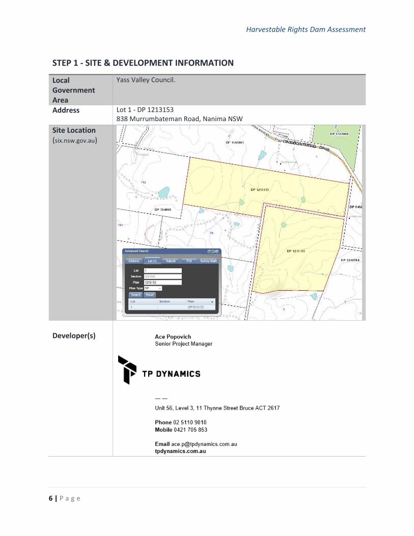
Local Government Area
Yass Valley Council.
Address
Lot 1 - DP 1213153 838 Murrumbateman Road, Nanima NSW
Site Location (six.nsw.gov.au)
Developer(s)
Harvestable Rights Dam Assessment
7 | P a g e
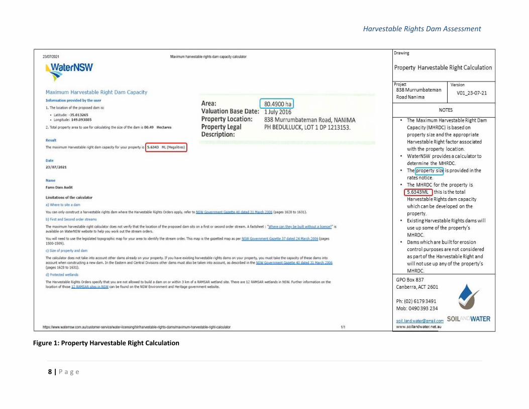
STEP 2 – CALCULATE PROPERTY HARVESTABLE RIGHTS
Property Harvestable Right
The Harvestable Right (HR) attributable to the property is calculated using the Department of Primary Industries (Office of Water) calculator by locating the property on the map then entering the total property area and using the tool to determine the HR for the property, refer Figure 1.
The HR for the property: 5.6343 ML
Harvestable Rights Dam Assessment
8 | P a g e
Figure 1: Property Harvestable Right Calculation
Harvestable Rights Dam Assessment
9 | P a g e
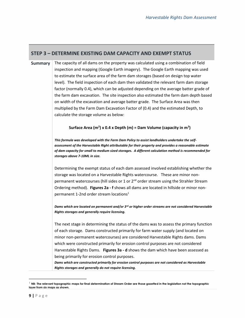
STEP 3 – DETERMINE EXISTING DAM CAPACITY AND EXEMPT STATUS
Summary
The capacity of all dams on the property was calculated using a combination of field
inspection and mapping (Google Earth imagery). The Google Earth mapping was used
to estimate the surface area of the farm dam storages (based on design top water
level). The field inspection of each dam then validated the relevant farm dam storage
factor (normally 0.4), which can be adjusted depending on the average batter grade of
the farm dam excavation. The site inspection also estimated the farm dam depth based
on width of the excavation and average batter grade. The Surface Area was then
multiplied by the Farm Dam Excavation Factor of (0.4) and the estimated Depth, to
calculate the storage volume as below:
Surface Area (m2) x 0.4 x Depth (m) = Dam Volume (capacity in m3)
This formula was developed with the Farm Dam Policy to assist landholders undertake the self-
assessment of the Harvestable Right attributable for their property and provides a reasonable estimate
of dam capacity for small to medium sized storages. A different calculation method is recommended for
storages above 7-10ML in size.
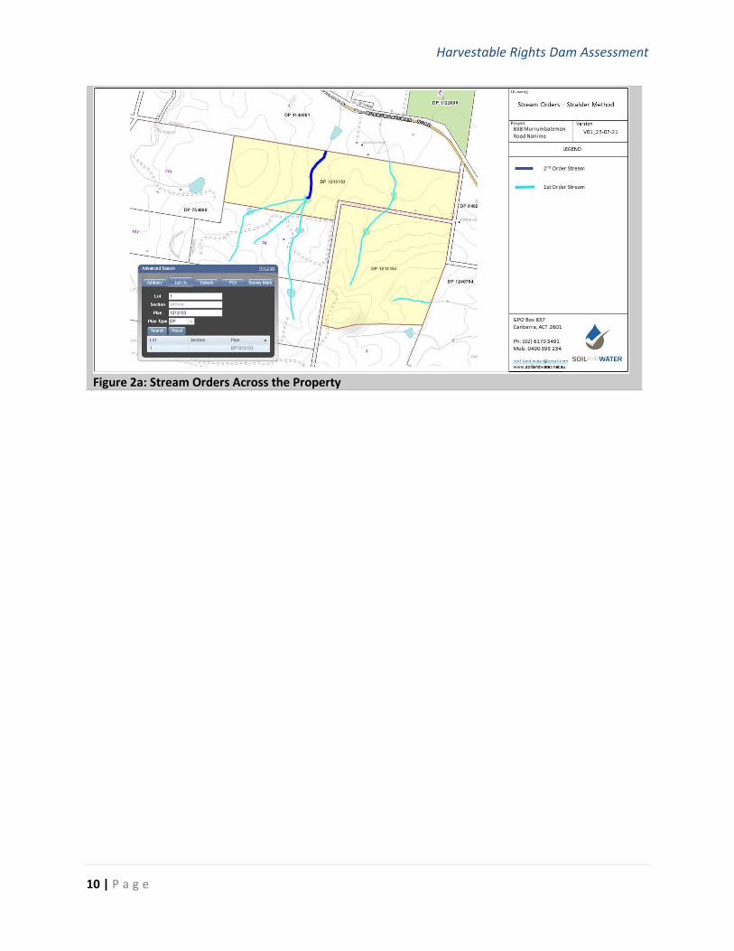
Determining the exempt status of each dam assessed involved establishing whether the
storage was located on a Harvestable Rights watercourse. These are minor non-
permanent watercourses (hill sides or 1 or 2nd order stream using the Strahler Stream
Ordering method). Figures 2a - f shows all dams are located in hillside or minor non-
permanent 1-2nd order stream locations1
Dams which are located on permanent and/or 3rd or higher order streams are not considered Harvestable
Rights storages and generally require licensing.
The next stage in determining the status of the dams was to assess the primary function
of each storage. Dams constructed primarily for farm water supply (and located on
minor non-permanent watercourses) are considered Harvestable Rights dams. Dams
which were constructed primarily for erosion control purposes are not considered
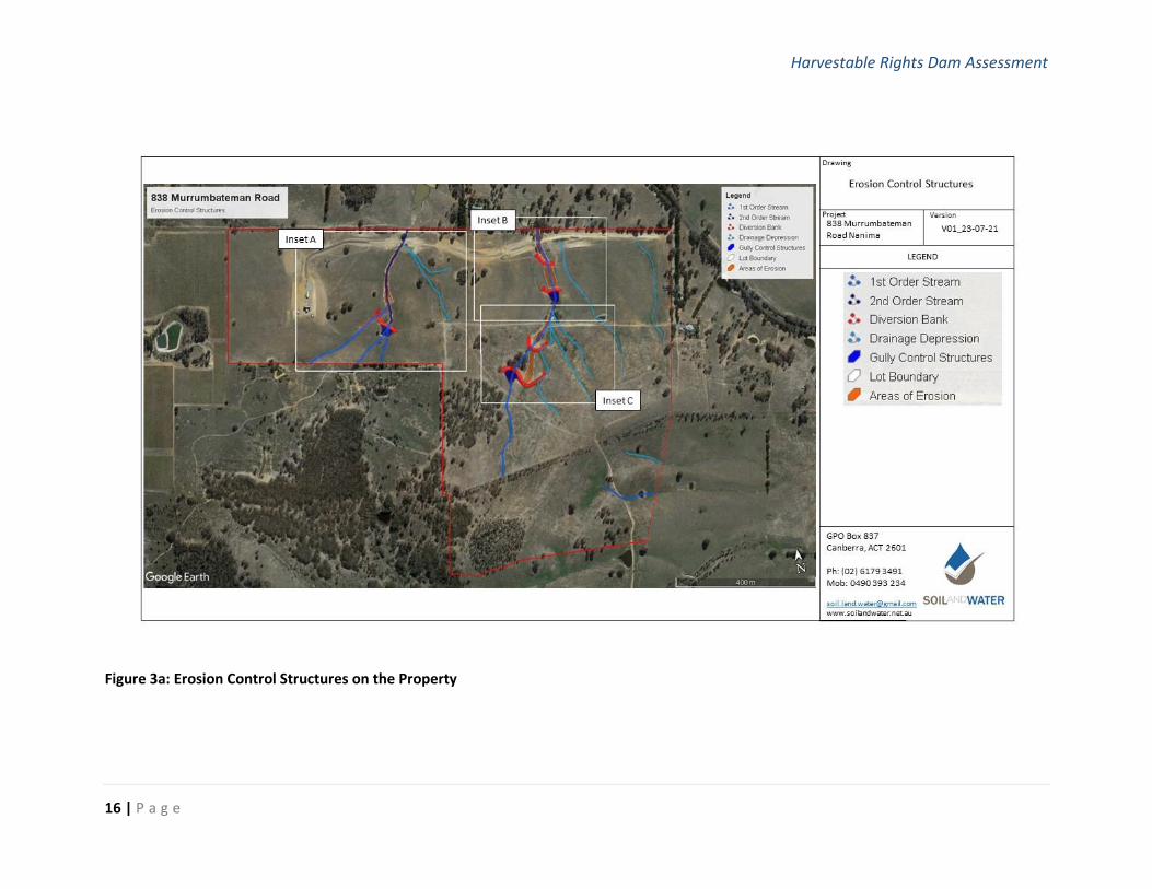
Harvestable Rights Dams. Figures 3a - d shows the dam which have been assessed as
being primarily for erosion control purposes.
Dams which are constructed primarily for erosion control purposes are not considered as Harvestable
Rights storages and generally do not require licensing.
1 NB: The relevant topographic maps for final determination of Stream Order are those gazetted in the legislation not the topographic
layer from six maps as shown.
Harvestable Rights Dam Assessment
10 | P a g e
Figure 2a: Stream Orders Across the Property

Harvestable Rights Dam Assessment
11 | P a g e
Figure 2b: Stream Orders and Dams Across the Property
Harvestable Rights Dam Assessment
12 | P a g e
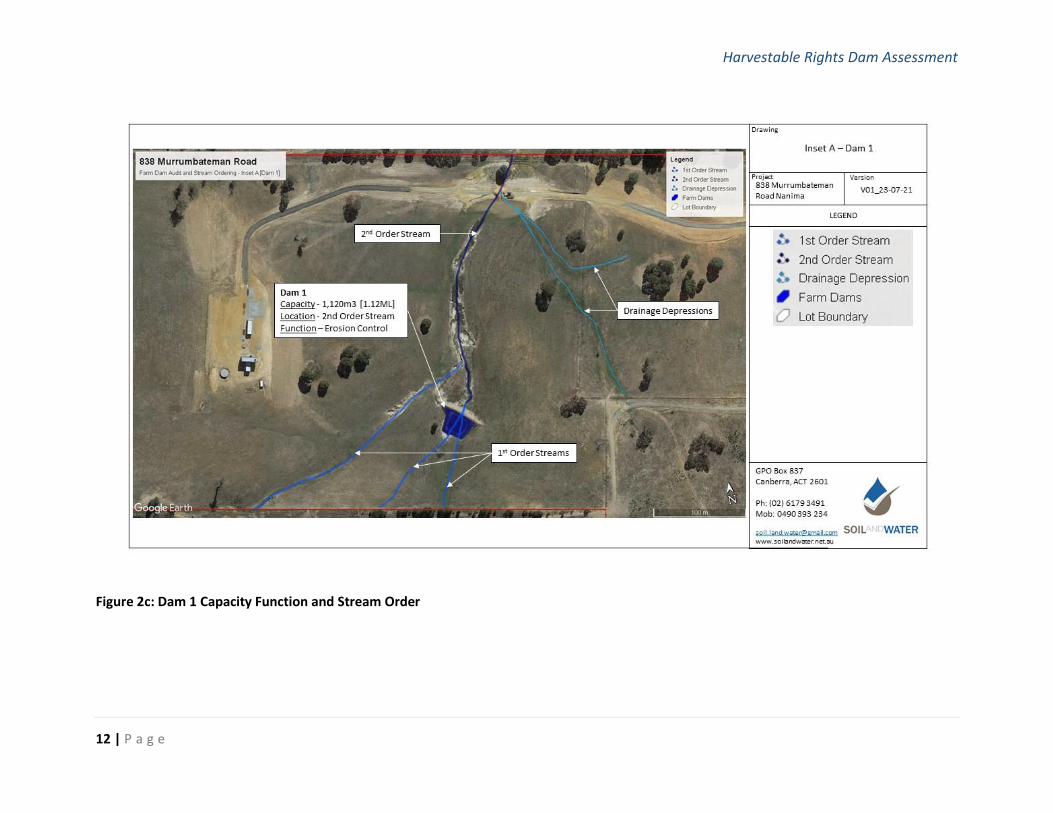
Figure 2c: Dam 1 Capacity Function and Stream Order
Harvestable Rights Dam Assessment
13 | P a g e
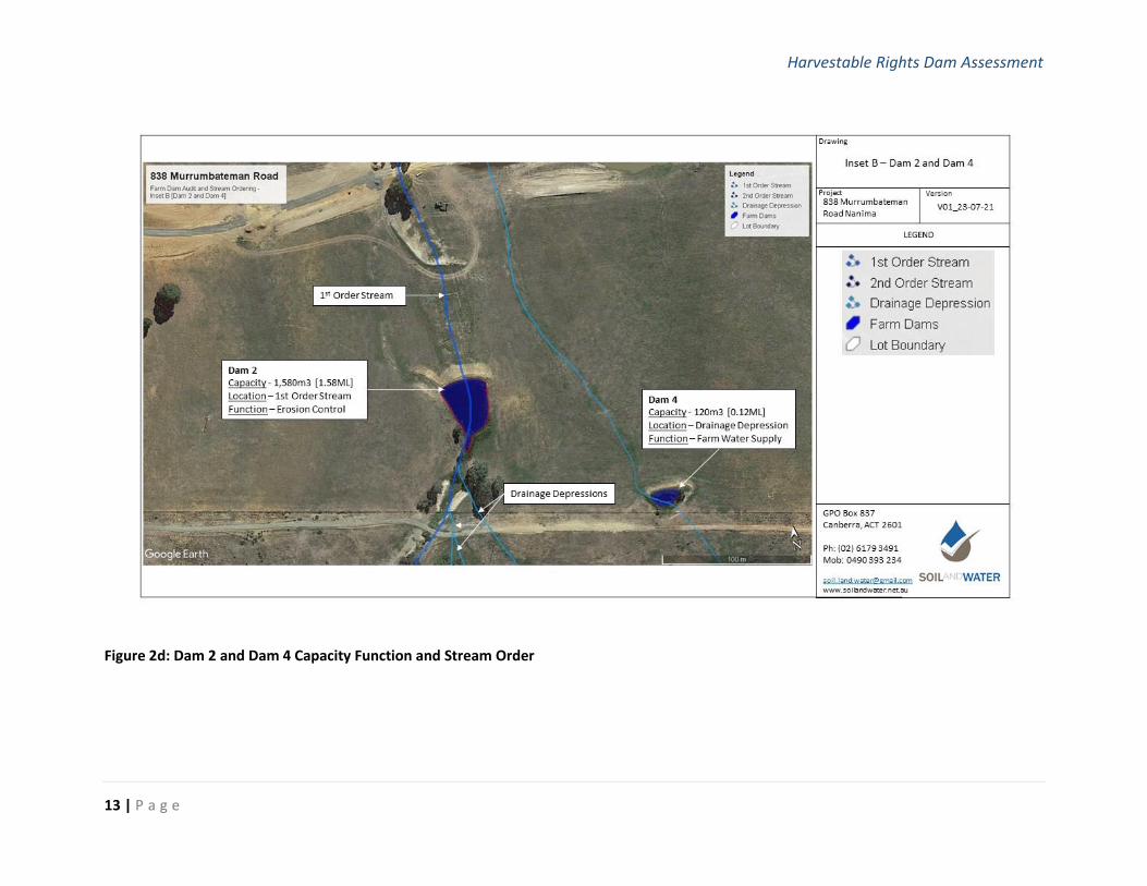
Figure 2d: Dam 2 and Dam 4 Capacity Function and Stream Order
Harvestable Rights Dam Assessment
14 | P a g e
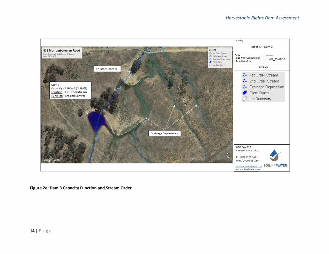
Figure 2e: Dam 3 Capacity Function and Stream Order
Harvestable Rights Dam Assessment
15 | P a g e
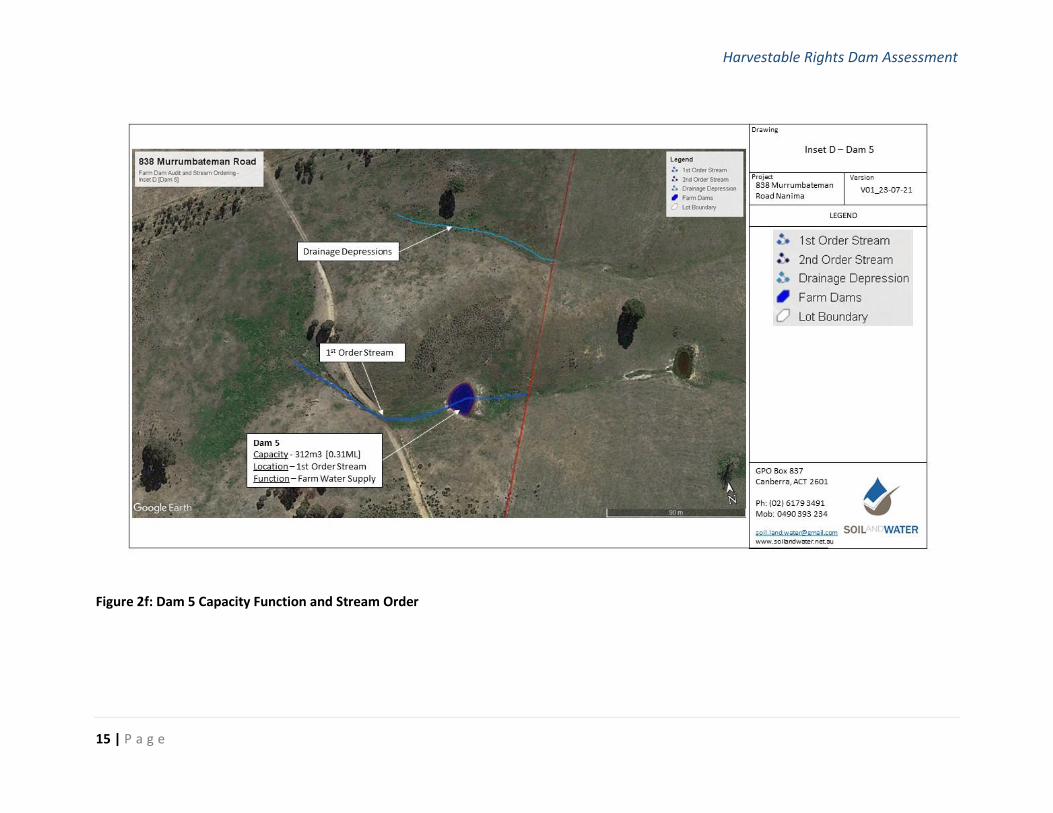
Figure 2f: Dam 5 Capacity Function and Stream Order
Harvestable Rights Dam Assessment
16 | P a g e
Figure 3a: Erosion Control Structures on the Property
Harvestable Rights Dam Assessment
17 | P a g e
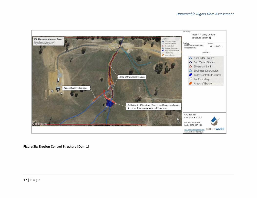
Figure 3b: Erosion Control Structure [Dam 1]
Harvestable Rights Dam Assessment
18 | P a g e
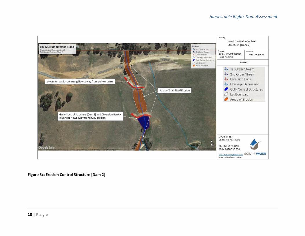
Figure 3c: Erosion Control Structure [Dam 2]
Harvestable Rights Dam Assessment
19 | P a g e
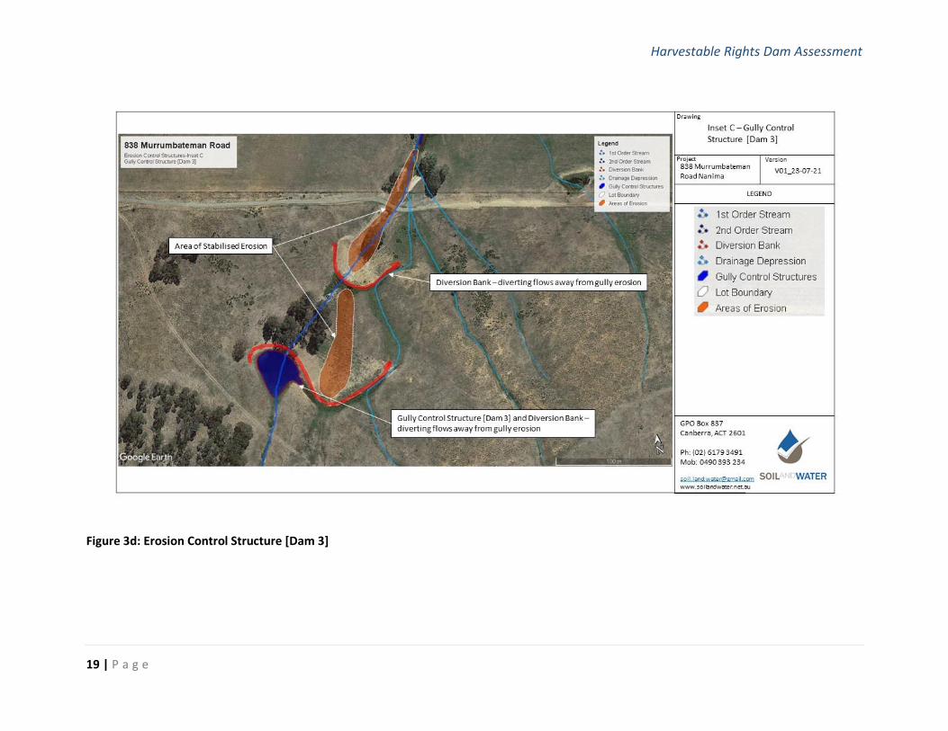
Figure 3d: Erosion Control Structure [Dam 3]
Harvestable Rights Dam Assessment
20 | P a g e
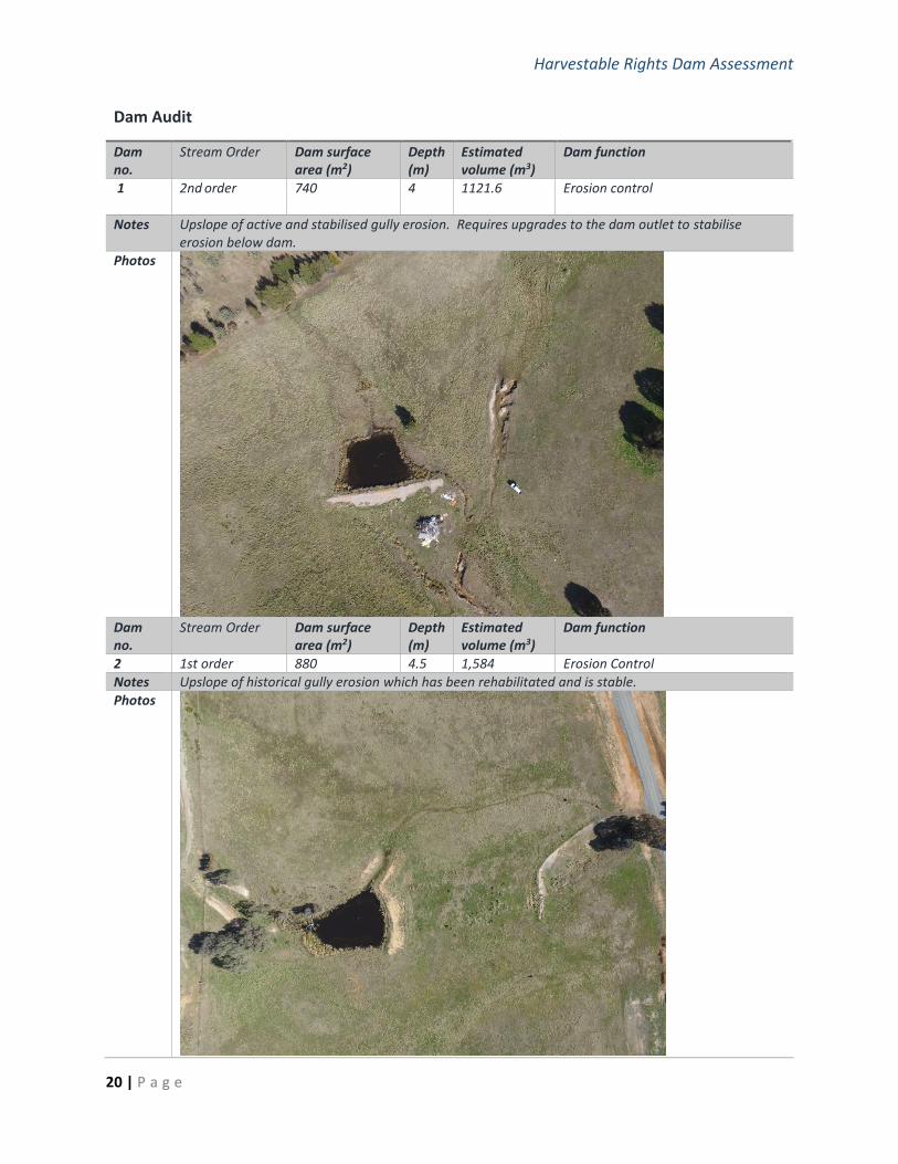
Dam Audit
Dam no.
Stream Order Dam surface area (m2)
Depth (m)
Estimated volume (m3)
Dam function
1 2nd order
740 4 1121.6 Erosion control
Notes Upslope of active and stabilised gully erosion. Requires upgrades to the dam outlet to stabilise erosion below dam.
Photos
Dam no.
Stream Order Dam surface area (m2)
Depth (m)
Estimated volume (m3)
Dam function
2 1st order 880 4.5 1,584 Erosion Control
Notes Upslope of historical gully erosion which has been rehabilitated and is stable.
Photos
Harvestable Rights Dam Assessment
21 | P a g e
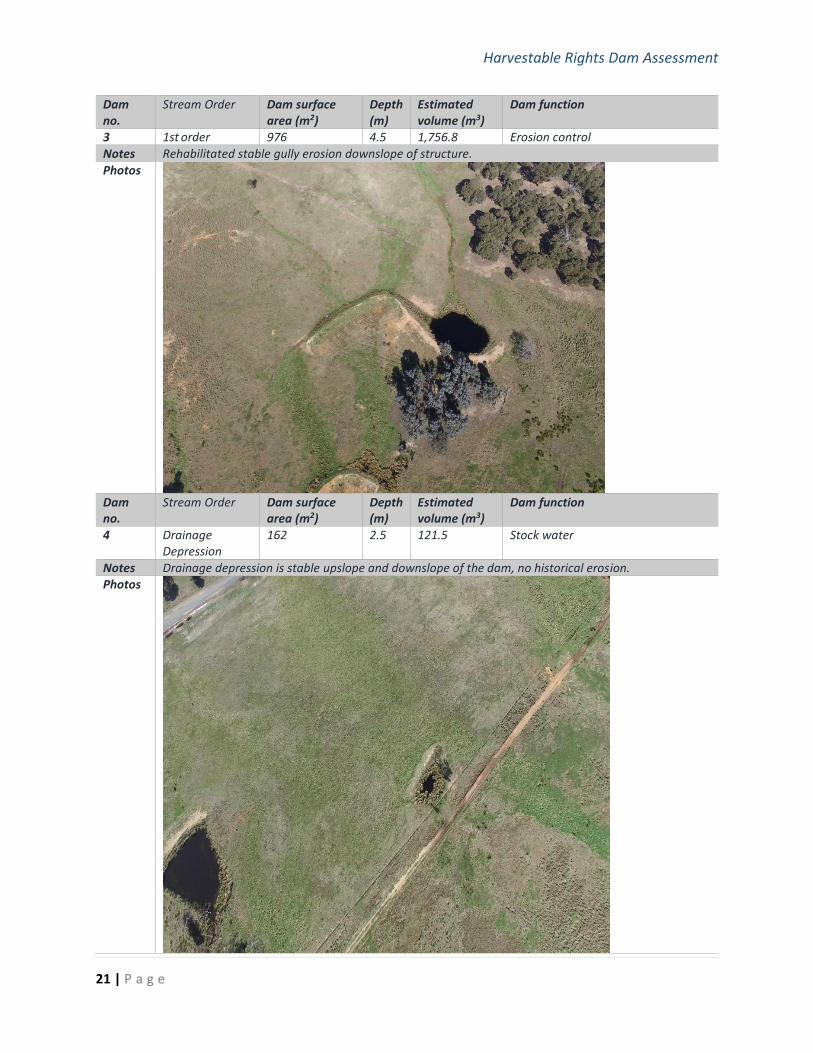
Dam no.
Stream Order Dam surface area (m2)
Depth (m)
Estimated volume (m3)
Dam function
3 1st order 976 4.5 1,756.8 Erosion control
Notes Rehabilitated stable gully erosion downslope of structure.
Photos
Dam no.
Stream Order Dam surface area (m2)
Depth (m)
Estimated volume (m3)
Dam function
4 Drainage Depression
162 2.5 121.5 Stock water
Notes Drainage depression is stable upslope and downslope of the dam, no historical erosion. Photos
Harvestable Rights Dam Assessment
22 | P a g e
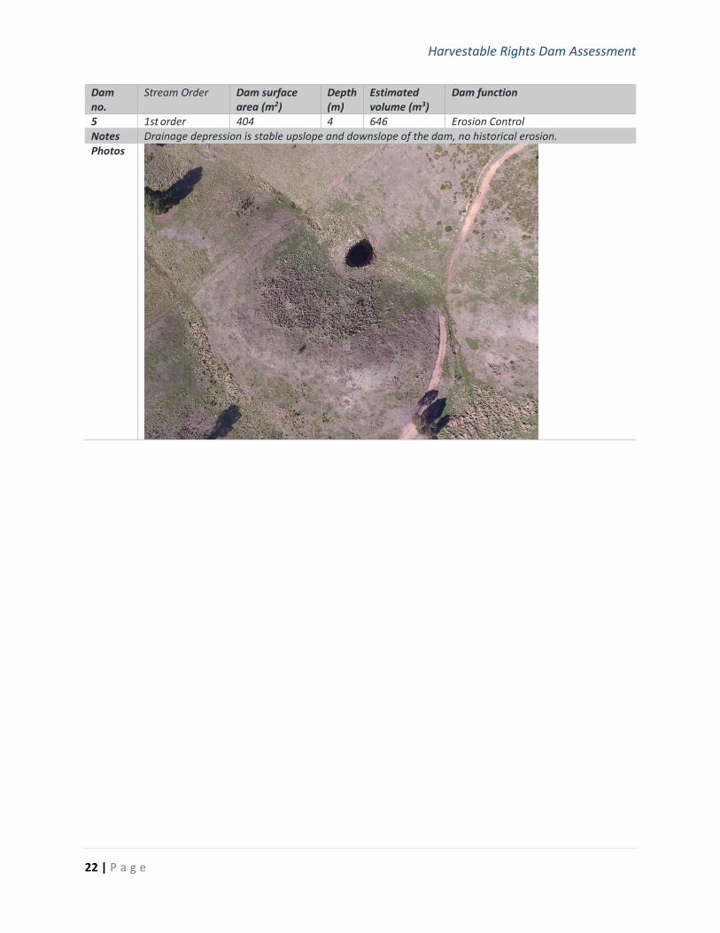
Dam no.
Stream Order Dam surface area (m2)
Depth (m)
Estimated volume (m3)
Dam function
5 1st order 404 4 646 Erosion Control
Notes Drainage depression is stable upslope and downslope of the dam, no historical erosion.
Photos
Harvestable Rights Dam Assessment
23 | P a g e
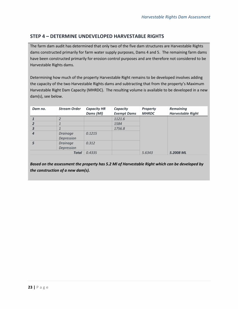
STEP 4 – DETERMINE UNDEVELOPED HARVESTABLE RIGHTS
The farm dam audit has determined that only two of the five dam structures are Harvestable Rights
dams constructed primarily for farm water supply purposes, Dams 4 and 5. The remaining farm dams
have been constructed primarily for erosion control purposes and are therefore not considered to be
Harvestable Rights dams.
Determining how much of the property Harvestable Right remains to be developed involves adding
the capacity of the two Harvestable Rights dams and subtracting that from the property’s Maximum
Harvestable Right Dam Capacity (MHRDC). The resulting volume is available to be developed in a new
dam(s), see below.
Dam no. Stream Order Capacity HR Dams (Ml)
Capacity Exempt Dams
Property MHRDC
Remaining Harvestable Right
1 2 1121.6
5.6343 5.2008 ML
2 1 1584
3 1 1756.8
4 Drainage Depression
0.1215
5 Drainage Depression
0.312
Total 0.4335
Based on the assessment the property has 5.2 Ml of Harvestable Right which can be developed by
the construction of a new dam(s).
Harvestable Rights Dam Assessment
24 | P a g e
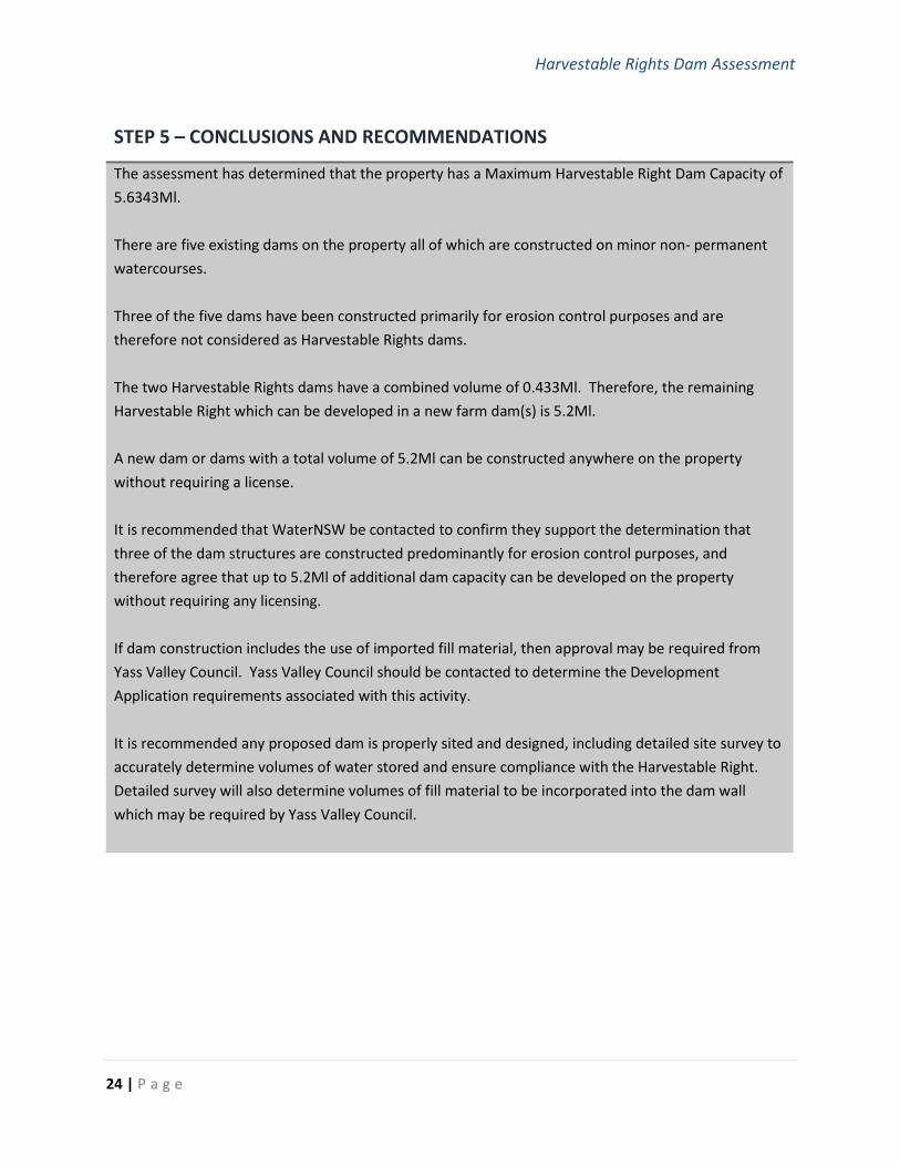
STEP 5 – CONCLUSIONS AND RECOMMENDATIONS
The assessment has determined that the property has a Maximum Harvestable Right Dam Capacity of
5.6343Ml.
There are five existing dams on the property all of which are constructed on minor non- permanent
watercourses.
Three of the five dams have been constructed primarily for erosion control purposes and are
therefore not considered as Harvestable Rights dams.
The two Harvestable Rights dams have a combined volume of 0.433Ml. Therefore, the remaining
Harvestable Right which can be developed in a new farm dam(s) is 5.2Ml.
A new dam or dams with a total volume of 5.2Ml can be constructed anywhere on the property
without requiring a license.
It is recommended that WaterNSW be contacted to confirm they support the determination that
three of the dam structures are constructed predominantly for erosion control purposes, and
therefore agree that up to 5.2Ml of additional dam capacity can be developed on the property
without requiring any licensing.
If dam construction includes the use of imported fill material, then approval may be required from
Yass Valley Council. Yass Valley Council should be contacted to determine the Development
Application requirements associated with this activity.
It is recommended any proposed dam is properly sited and designed, including detailed site survey to
accurately determine volumes of water stored and ensure compliance with the Harvestable Right.
Detailed survey will also determine volumes of fill material to be incorporated into the dam wall
which may be required by Yass Valley Council.
Harvestable Rights Dam Assessment
25 | P a g e
Appendix A: Assessors’ Curriculum Vitae
CU RRI CUL UM V I T A E
John Franklin
NATURAL RESOURCE MANAGEMENT PROFESSIONAL
QUALIFICATIONS
• Master of Applied Science in Agriculture and Rural development, University Western Sydney,1993
• Bachelor of Science, University of Wollongong, 1989
• Environment Institute of Australia and New Zealand (Full Member)
• Certified Environmental Practitioner (CEnvP No.1320)
John has over 30 years’ experience working in Natural Resource Management across organisations in NSW, ACT and
Queensland. This ranges from the design, planning and implementation of on-ground works to the development of
state NRM policy. The extent and depth of John’s experience provides him with a superior understanding of all aspects
of NRM.
John established Soil and Water in 2016 to better service the agricultural, development, government and industry
sectors with professional natural resource management advice focusing on soil and water management.
Prior to this John had been a senior executive manager responsible for staff management, business system
development, organisational strategy, program design, business growth and diversification and financial management.
John’s experience is reflected in the following key skills:
• Extensive technical skills in sediment and erosion control, soil and water management and the design and implementation of remedial works programs.
• Excellent communication skills
• Facilitation and conflict resolution skills
• Ability to engage and influence a wide range of stakeholders
• High Level Project Management skills
• Exceptional ability to translate complex scientific concepts into user friendly tools
• Highly developed technical NRM skills
• Excellent staff management skills
• NRM Policy Development experience
• Australian Government NRM experience
• Private consulting experience
• Major NRM Project Management experience
• Extensive NRM network across Agencies, private sector and all levels of Government
• Financial & Budget Management
Harvestable Rights Dam Assessment
26 | P a g e
RELEVANT PROJECT S
SOIL & WATER MANAGEMENT
• Provide professional soil and water advice to landholders along the APA Gas Pipeline in Wallendbeen, NSW
• Design and deliver sediment and nutrient reduction projects for cane and cattle producers in catchments draining to the Great Barrier Reef for the Mackay Whitsunday Isaacs NRM Group.
• Design and deliver the Yass Riparian Restoration project for the Murrumbidgee Catchment Management Authority
• Produce a Gully Erosion Control Management Guide for the Department of Land and Water Conservation
• Develop a prioritised work plan for remedial sediment and erosion control track-works required across the Defence Estate in the Shoalhaven
• Design and deliver the Drought Ready project across NSW for the National Landcare Program
• Sustainable Use Guidelines for Stock and Domestic Water Use
• Analyse sustainable surface and groundwater use across the Yass River catchment and produce the “Yass
Snapshot on Sustainability”
• Design an effluent management system for the Mugga Lane Resource Recovery Centre, Canberra ACT POLICY, PLANNING & ANALYSIS
• Develop the NSW Farm Dams Policy for the Department of Land and Water Conservation
• Deliver the water reforms in the Upper Murrumbidgee including managing the water amnesty process
• Analysis of the implementation of National Water Initiative guidelines for managing the impact of interception
land use activities on groundwater resources
• Develop and undertake audit of NSW regional NRM bodies to determine the effectiveness and efficiency of organisations in the delivery of NRM programs
• Manage the development of Natural Resource Management Plan for the Mackay Whitsunday Isaacs NRM Region
• Manage the development of Next Generation Natural Resource Management Plan for Murrumbidgee
Catchment Management Authority
• Analysis of surface and groundwater usage in the Yass River Catchment
• Develop property management planning process for Murrumbidgee Catchment Management Authority MONITORING & EVALUATION
• Development of Monitoring & Evaluation Strategy to support the NSW State-wide Resource Condition
Targets
• Identification of monitoring Indicators to support NSW Monitoring & Evaluation Strategy
• Develop and implement surface and groundwater monitoring regime for the Majura Field Firing Range
Harvestable Rights Dam Assessment
27 | P a g e
RELEVANT EXPERIENCE
Director, Principle Consultant, Soil and Water April 2016 Achievements:
• Establish a new Natural Resource Management business which delivers integrated services to the development, government, agricultural and industry sectors in and around the ACT
• Develop new service lines which enable clients to contract one business to deliver a range of technical specialties
• Build capacity across the wastewater/effluent management sector to improve outcomes for public health and the environment
Responsibilities:
• Management of the company including subcontractors
• Project Management and delivery of major NRM projects across the ACT and south east NSW.
• Developing and approving proposals and winning work for the company
• Building organisational capacity and credibility across an expanding range of services Manager, Eco Logical Australia (ELA), Canberra 2 years Achievements:
• Build and diversify the Canberra client base for ELA
• Recruit and build an integrated service delivery team
• Increase the profitability of the Canberra Office
• Deliver integrated natural resource management project to key local government and development sector clients
Responsibilities:
• Canberra Office management including budget development, staff management and recruitment
• Develop and implement strategic marketing strategies for ELA
• Lead ELA liaison with the Defence sector
• Stakeholder relationship management and work winning for the Canberra team General Manager, Reef Catchments Limited Reef Catchments, Proserpine QLD 2 years
Achievements:
• Design and manage the implementation of the new organisational structure for the Reef Catchments Group and Reef Catchments Limited.
• Build new organisational culture and manage staff through change process.
• Increase the relevance of Reef Catchments Limited amongst key stakeholders and the community.
• Manage the development of a next generation Natural Resource Management Plan in collaboration with the community.
Responsibilities:
• Delivery of all Reef Catchments Program and projects.
• Develop and maintain key stakeholder relationships
• Grow and diversify investments available to Reef Catchments to implement NRM across the region
• Manage staff to ensure efficient and effective program delivery
• Development of business systems to ensure effective program delivery
• Manage finances and budgets
• Work as a member of the Executive Management Team to identify and address strategic management issues for the Reef Catchments Group.
Manager Industry & Sustainability National Water Commission, Canberra ACT 1 year
Achievements:
Harvestable Rights Dam Assessment
28 | P a g e
• Develop National Project to assess the management of interception activities such as farm dams, plantations
and bores.
• Develop and facilitate the engagement meetings with states and territories.
• Develop and host a national forum on Interception Management involving all state and territory water and
land use management agencies.
Responsibilities:
• Promote the National Water Initiative to State and Territory jurisdictions.
• Develop project management plans and manage the delivery of NWC projects.
• Manage project budgets according to NWC and Financial Management Audit Act.
• Report project progress to Executive committee and the Commissioners.
• Develop and maintain stakeholder relationships
• Provide leadership and managing/mentoring role to staff. Program Manager Murrumbidgee Catchment Management Authority, Yass NSW 6 years
Achievements:
• Developed new Business Model for Murrumbidgee Catchment Management Authority
• Developed Stakeholder Engagement Strategy
• Developed the Murrumbidgee Catchment Management Authority- Catchment Action Plan
• Established tendering and procurement processes associated with the implementation of Murrumbidgee
CMA’s major works programs.
• Developed, managed and implemented major Drought Recovery project with stakeholders and collaborators.
• Managed the delivery of numerous Natural Resource Management Projects and programs throughout the
Murrumbidgee.
• Development of Knowledge Management Strategy.
• Development of Promoting Partnerships Strategy.
Responsibilities:
• Manage the delivery of all Murrumbidgee CMA’s activities in the Upper Murrumbidgee area.
• Manage team of up to 30 staff to assist in delivery of Murrumbidgee CMA activities.
• Manage facilities, motor vehicles and budgets.
• Stakeholder relationship development and management.
• Market the Murrumbidgee CMA’s activities and organisation to the broader community.
• Represent the organisation on Committees and liaison groups.
• Provide strategic NRM support and direction to the CMA and the Board.
• Act in the position of General Manager as required.
Natural Resource Analyst Natural Resources Commission, Sydney NSW 2 years
Achievements:
• Developed NRC Monitoring and Evaluation Recommendations to NSW Government, subsequently adopted.
• Provided effective Secretariat Support to the Ministerial Review Committee on Native Vegetation Reforms.
• Provided strategic NRM support to all NRC projects and reviews.
Responsibilities:
• Developed an option for monitoring and evaluation arrangements to support the state-wide resource condition
targets recommended to NSW government.
• Provided timely, quality, independent advice to Government on NRM issues.
• Drafted comprehensive Ministerial Reports summarising complicated NRM issues into concise, simple
language according to strict deadlines.
• Provided secretariat support to the Ministerial Review Committee on the Native Vegetation Management Act.
Harvestable Rights Dam Assessment
29 | P a g e
• Provided NRM advice and strategic direction and input to all of NRC projects and Independent Reviews. Senior Environmental Officer Gutteridge, Haskins & Davies, Belconnen, ACT (engaged by NRC between February and September 2005)
Achievements:
• Majura Field Firing Range Surface and Groundwater Monitoring Strategy for Department of Defence.
• Monitoring and Evaluation Strategy to support State-wide Resource Condition Targets NRC.
• Winning long-term NRM audit contracts with NRC.
Responsibilities:
• Promoted and marketed the company to a wider client base utilising my extensive NRM network.
• Developed innovative and integrated NRM /Planning products to secure contracts with expanding client base.
• Managed and delivered water quality projects.
• Managed and delivered long term-lucrative contracts.
• Assistant Director Department of Environment, Canberra ACT
Achievements:
• Developed NAP & NHT Report for Tabling to Government
• Improved Monitoring & Evaluation reporting process of jurisdictions
• Developed process for collating funding program reporting to government
Responsibilities:
• Liaise with state and territory jurisdictions to collect monitoring & evaluation data and information.
• Provide high quality and timely ministerial briefings on the performance of the governments key NRM policies
• Collect monitoring and evaluation data and information from government delivered NRM programs. Landscape Manager DIPNR (DLWC, C&LM, SCS), Temora, Wagga Wagga, West Wyalong, Braidwood and Yass NSW 15 years Achievements:
• Yass Snapshot on Sustainability, Yass Riparian Management (draft), Gully Erosion Control Options
Publications
• Development and implementation of NSW Farm Dams Policy
• Sustainable Development Practices for Rural Residential Development in ACT Region
• Yass Area Network of Landcare Groups Catchment Action Plan
• Improved land management practices across Upper Murrumbidgee Catchment
Responsibilities:
• community and other NRM stakeholders.
• Implement Government legislation on water, vegetation and land management.
• Develop and promote good NRM policy.
• Manage District Cost Centres including staff, plant and premises.
• Represent the Department at forums, on committees.
• Educate wider community about sustainable land management, including overseas visitors, Australian
Government, University and school groups.
• Integrate good NRM into strategic plans of stakeholders such as local government, planning agencies.
• Develop and implement NRM projects to deliver good environmental, social and economic outcomes