Embed Size (px)
Citation preview
Str 3
Str 1
Str 3A
Str 1F
Str 1G
Str 3F
Str 1E
Str 3F
Str 3F1Str 1F
Str 1G1Str 1
Str 1G
Str 3D
392(A21)
148(A8)
588(29)
430(22)
289(15)
721(36)
147(7:1)
485(A25)
1627(75:1)
1230(5
5:1)
337(18)=0(A1)
268(A14)
1428(6
6:1)=0(1
)
88(F8)
1224(5
5)=0(F
1)
11(F2)
1732(82)
1212
(54)
1352(6
2:1)Lake19
THR0
02-2
THR002-3
THR002-1
Lake
19E
Lake19
Lake19E
THR002-4
FS4
FS2
FS1MT65MT64MT63
MT62
MT27MT28
MT20
MT61
MT60
MT26MT22
MT25
MT30
FS3
FLTCA87661
Schedule 6Sub Basin 322
Schedule 6Sub Basin 335
Schedule 6Sub Basin 316
32
31
43
44
42
41
40
39
3837
3635
34
33
3059
58
5756
5554
53
52
51
50
49
4746
45
60
THR003
THR002A
THR001
200
300
280
290
270 260
250
190
210
220
240
330
320
310
230
340
180
350360
170
370
160
380 390
150
140
130
400410410
200
370
330
340
320
400
180
350
270
210
250
380
210
350
310
180
280
250
360
120
NAD 83 BC Albers0 50 100 150 200 250
Metres1:5,000
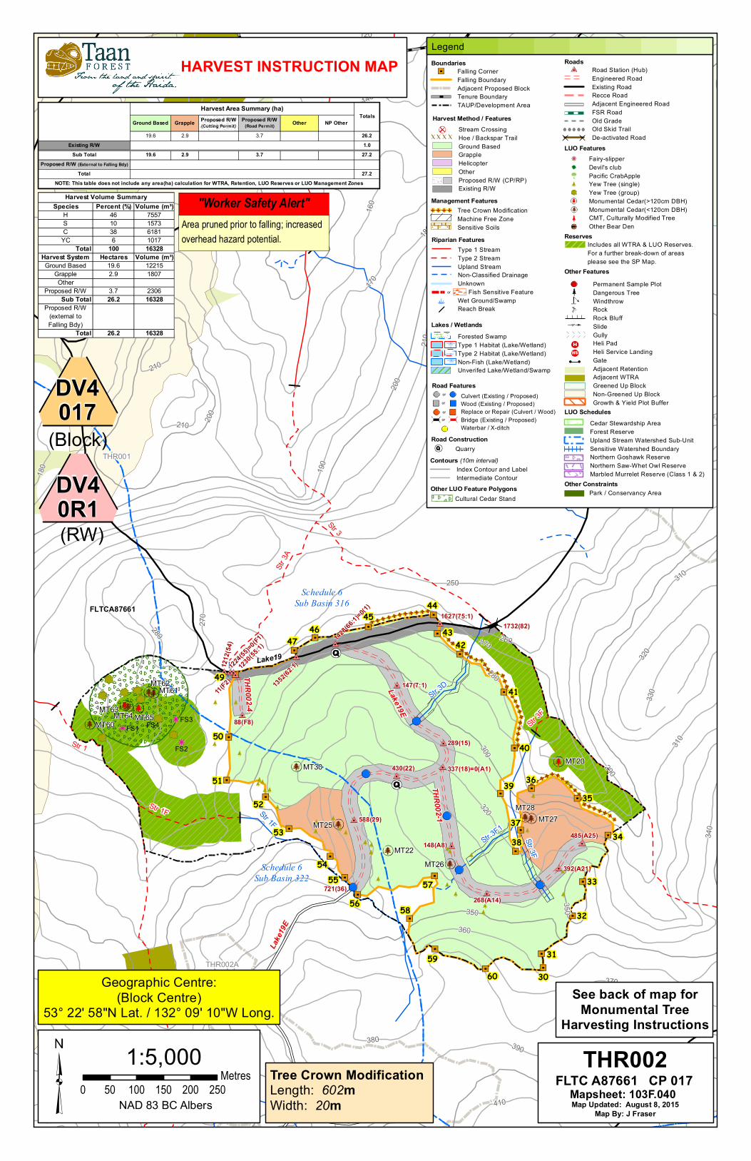
Geographic Centre:(Block Centre)
53° 22' 58"N Lat. / 132° 09' 10"W Long.
Tree Crown ModificationLength: 602mWidth: 20m
"Worker Safety Alert"Area pruned prior to falling; increasedoverhead hazard potential.
See back of map forMonumental Tree
Harvesting Instructions
HARVEST INSTRUCTION MAP
(RW)
DV40R1
Ground Based Grapple Proposed R/W (Cutting Permit)
Proposed R/W (Road Permit) Other NP Other
19.6 2.9 3.7 26.2Existing R/W 1.0
Sub Total 19.6 2.9 3.7 27.2Proposed R/W (External to Falling Bdy)
Total 27.2NOTE: This table does not include any area(ha) calculation for WTRA, Retention, LUO Reserves or LUO Management Zones
Harvest Area Summary (ha)Totals
(Block)
DV4017
Legend
Riparian FeaturesType 1 Stream Type 2 StreamUpland StreamNon-Classified DrainageUnknown Fish Sensitive FeatureWet Ground/SwampReach Break
or
RoadsRoad Station (Hub)Engineered RoadExisting RoadRecce RoadAdjacent Engineered RoadFSR RoadOld GradeOld Skid TrailDe-activated Road
Contours (10m interval)Index Contour and LabelIntermediate Contour
BoundariesFalling CornerFalling BoundaryAdjacent Proposed BlockTenure BoundaryTAUP/Development Area
Management FeaturesTree Crown ModificationMachine Free ZoneSensitive Soils
Road FeaturesCulvert (Existing / Proposed)Wood (Existing / Proposed)Replace or Repair (Culvert / Wood)Bridge (Existing / Proposed)Waterbar / X-ditch
or
or
or
or
ReservesIncludes all WTRA & LUO Reserves.For a further break-down of areasplease see the SP Map.
Other ConstraintsPark / Conservancy Area
Other FeaturesPermanent Sample PlotDangerous TreeWindthrowRockRock BluffSlideGullyHeli PadHeli Service LandingGateAdjacent RetentionAdjacent WTRAGreened Up BlockNon-Greened Up BlockGrowth & Yield Plot Buffer
Lakes / WetlandsForested SwampType 1 Habitat (Lake/Wetland)Type 2 Habitat (Lake/Wetland)Non-Fish (Lake/Wetland)Unverifed Lake/Wetland/Swamp
Road ConstructionQuarry
Harvest Method / FeaturesStream CrossingHoe / Backspar TrailGround BasedGrappleHelicopterOtherProposed R/W (CP/RP)Existing R/W
LUO SchedulesCedar Stewardship AreaForest ReserveUpland Stream Watershed Sub-UnitSensitive Watershed BoundaryNorthern Goshawk ReserveNorthern Saw-Whet Owl ReserveMarbled Murrelet Reserve (Class 1 & 2)
Other LUO Feature PolygonsCultural Cedar Stand
LUO FeaturesFairy-slipperDevil's clubPacific CrabAppleYew Tree (single)Yew Tree (group)Monumental Cedar(>120cm DBH)Monumental Cedar(<120cm DBH)CMT, Culturally Modified TreeOther Bear Den
Species Percent (%) Volume (m³)H 46 7557S 10 1573C 38 6181
YC 6 1017Total 100 16328
Harvest System Hectares Volume (m³)Ground Based 19.6 12215
Grapple 2.9 1807Other
Proposed R/W 3.7 2306Sub Total 26.2 16328
Proposed R/W (external to Falling Bdy)
Total 26.2 16328
Harvest Volume Summary
Map Updated: August 8, 2015Map By: J Fraser
THR002FLTC A87661 CP 017
Mapsheet: 103F.040

Harvesting Instructions Cut block: THR002
Template Version Date: October 2015
In addition to these site specific instructions, all operations must be carried out in accordance with the Contract and Taan’s CMS.
HARVESTING STRATEGIES AND CONSTRAINTS
If anything is unclear in this plan, or if field marking does not match the map, contact Taan’s Manager or Supervisor Ground Based including back spar trails: Soils are very susceptible to compaction particularly when saturated. The use of ground based equipment will be limited to drier soil conditions and/or using puncheon. Puncheon will be dispersed following the completion of harvest activities to facilitate planting. - Maximum allowable soil disturbance = 5% - Maximum road side soil disturbance = 25% to allow for decking/loading logs. - Utilize sufficient puncheon during ground based operations - Harvesting operations will cease immediately should compaction or rutting occur - Rehabilitate compacted soils and rutted areas once soils are sufficiently drained to allow for the return of machinery - Avoid ground based systems immediately after heavy rainfall events or when wet soil conditions exist - Maintain 7m MFZ on all streams. No tracks to enter MFZ area along stream, including roadside Cable Based: - Ensure adequate deflection during cable yarding to avoid screefing, gouging and excessive soil disturbance - Where use of back spars is prescribed. Use puncheon to avoid soil compaction. Deactivate trails when complete by dispersing puncheon and creating plantable spots along the trail when trail use is complete. - Work around standing stems of yew where possible.
Falling: - Hemlock more than 3m in height is to be cut down to reduce the spread of mistletoe where hemlock is a preferred species except within 7m MFZ areas along streams - Do not fall individual stems of yew unless a safety hazard.
Deactivation: Upon completion of harvesting, ensure the ditches, culverts and road ways are clear of debris and are managing water well. Re-establish sumps at culverts. THR002-1 and THR002-4 will be permanently deactivated. Remove all culverts, clean ditches and maintain drainage patterns (Cross ditches and water bars (herring bones) to keep water off road. Maintain 4X4 access on THR002-1 for planting and future surveys. Rock needs to be installed on cross ditch bottoms Pull all hoe trails and spread puncheon evenly. Decompact soils where compacted
Invasive Plants, Sedimentation and Erosion Control: - Wash equipment before moving from an area of known invasive plants before moving into a new area. - Invasive plant parts removed from machinery should be burned. Where burning is not possible dispose of in landfill area. - Any invasive plant found must be brought to the attention of Taan Forest. - Seed contiguous areas of exposed soil that exceed 0.1 ha within 1 year of completing activity. Where readily available and comparable in cost, preference must be given to grass seed that is:
1. high sod-forming content, except in areas that are planted with tree seedlings; 2. certified by the Canadian Seed Growers Association that the seed; a) meets Common #1 Forage Grade or better standards for varietal purity established by the Association for seed of that kind of species (Seeds Act, Seeds Regulation S. 2(1); and b) is of native origin.
ISSUES OR CONCERNS ACTIONS TO ACCOMMODATE
Safety
Refer to Taan Pre-work document prior to starting Falling and Harvesting activities.
Pruning operations may be completed prior to falling. Overhead hazard potential has increased along pruning boundaries (see map).
Dangerous Trees outside the harvest boundary – Operations will be in accordance with Work Safe BC Regulations. Where possible “No Work Zones” will be established. Danger Trees felled within a Wildlife Tree Retention Areas or Reserve Areas are not to be utilized..
If the Dangerous Tree must be felled, mark an “X” on the stump in the field and mark an “X” on the map for office use.
Recreation & Wildlife
If any raptor nests, heron rookeries or other previously unidentified features are found operations within the immediate vicinity of the feature must be stopped until a plan to manage the feature is developed.
If a bear den tree is found, contact a Taan representative immediately. No action is to be taken on the newly discovered bear den until Taan has reviewed the den.
Species at Risk: Goshawk
Monumental Cedar & Cultural Heritage Features
There are 6 monumentals designated for harvest in this cut block (see map) including 1 that should already be felled along the ROW. A representative of the Cultural Wood Program and Taan must be on site for falling. Alternatively, specific written instructions may be provided by Taan for falling and bucking instructions. When the tree(s) are felled paint the tree with tree number the block name and date felled. Engrave the tree number with saw on butt of log,. Handle all monumentals with care. The 1 tree along the ROW, if necessary may have to be remarked. All monumentals will be hauled to the Skidegate DLS for scaling where they will be temporarily stored.
If a CMT is encountered within the opening, whether alive or dead, standing or fallen, during any phase, logging will cease in the immediate vicinity of the CMT. Notification will be sent to Taan (Manager/Supervisor), Natural Resources (MFLNRO, MSRM (Archeology and Registry Services Branch)) and the Haida Nation. Taan direction must be received prior to operations proceeding.
Yew
Individual stems of yew are to be retained where safe to do so. Fall and yard away from stems, retain non-mech around individual stems. In ground based areas work around yew trees. Do not stack logs on trees. In cable yarding areas minimize roads and make all efforts to lift logs over yew trees, or designate a corridor to minimize yew destruction.
If yew must be felled try to leave high stumps and as many live branches as possible,
If yew is at roadside leave laid out for harvest by CHN, do not pile
Road Maintenance Maintain road access, kilometer signage, and public safety signage along roads. Stop road maintenance activities if siltation occurs.
Mitigate siltation entering streams by maintaining sumps along ditch lines and installing silt barriers (fences, hay bales etc.) along ditches and prior to creeks. Have ditch water flow into forest floor (filtered) before entering streams. Hauling may have to be curtailed when siltation starts in crabapple creek.
Slash Management
A planting density of 1200 sph across the cutblock must be obtained post-harvest. In areas of high slash accumulation pile slash, preferably on larger stumps, or create openings in the slash by moving slash around with the grapple or bucket of machine to create plantable spots.
Along roadside pile slash for disposal by burning. Create tall hay stack shaped piles with minimal dirt. Keep piles away from creeks / drainages and 100 feet from standing timber.
Windthrow Treatments
Pruning to be completed prior to falling or immediately after falling in the identified pruning areas (see map). Prune windthrow prone trees 20m beyond the falling boundary by removing 30% of the crown by spiral pruning and/or topping 10% of the crown where 30% of the crown cannot be removed by spiral pruning. All cut branches must be removed from the crowns to minimize overhead hazards for the next phases of block development. .
Sensitive Soils Use puncheon for all trails and removed/ deactivate trails by dispersing puncheon when complete.
Leave Trees: Retain individual yew stems where possible with non-merchantable trees.
RAINFALL SHUTDOWN CRITERIA Intermediate Zone
Activities must shut down when (whichever occurs first): Total rainfall reaches 75 mm in 24 hours; or Water balance is ≥ 75 mm; or Rainfall since start of the shift is 60mm and continuing.
Activities may start back-up when (whichever occurs first: Total rainfall is equal to or less than 30 mm in 48 hours or the water balance is < 75 mm.
QUARRIES, PITS, AND SPOIL SITES
DO NOT EXCAVATE A PIT, QUARRY OR SPOIL MATERIAL WITHIN THE RIPARIAN MANAGEMENT AREA (30m) OF ANY STREAM.
STREAMS Maintain streams in their natural channels. Do not disturb stable, in-stream large woody debris. Retain non-commercial trees and understory vegetation along riparian areas. Machine Free Zones (MFZs) on riparian areas is a minimum of 7m, including roadside
Creek I.D. CLASS MANAGEMENT STRATEGIES FOR RIPARIAN MANAGEMENT ZONES (RMZ) INCLUDING PROTECTING STREAM
Stream 3D, 3F, 3F1 Upland stream
Maintain 7m MFZ including roadside work and processing. Retain Non merchantable trees and stream side vegetation. Fall and yard away where possible. Cross stream yarding on these streams is permitted provided there is adequate lift to not disturb stream bank and vegetation. Bridging of streams during falling activities is permitted provided that the bank is not disturbed and trees can be lift clear.
1. Logs shall be decked perpendicular to the stream channel, stream flow will be maintained at all times, and any introduced materials will be removed immediately after loading.
2. Do not block or crush culverts with logs yarded to roadside – protect culvert openings and outflows.
3. No machinery is to be left parked within the RMA (30m) of any stream during shutdown periods (i.e., >5 days)
4. No maintenance on machinery or fuel storage is permitted within the RMA (30m) of any stream