Embed Size (px)
Citation preview
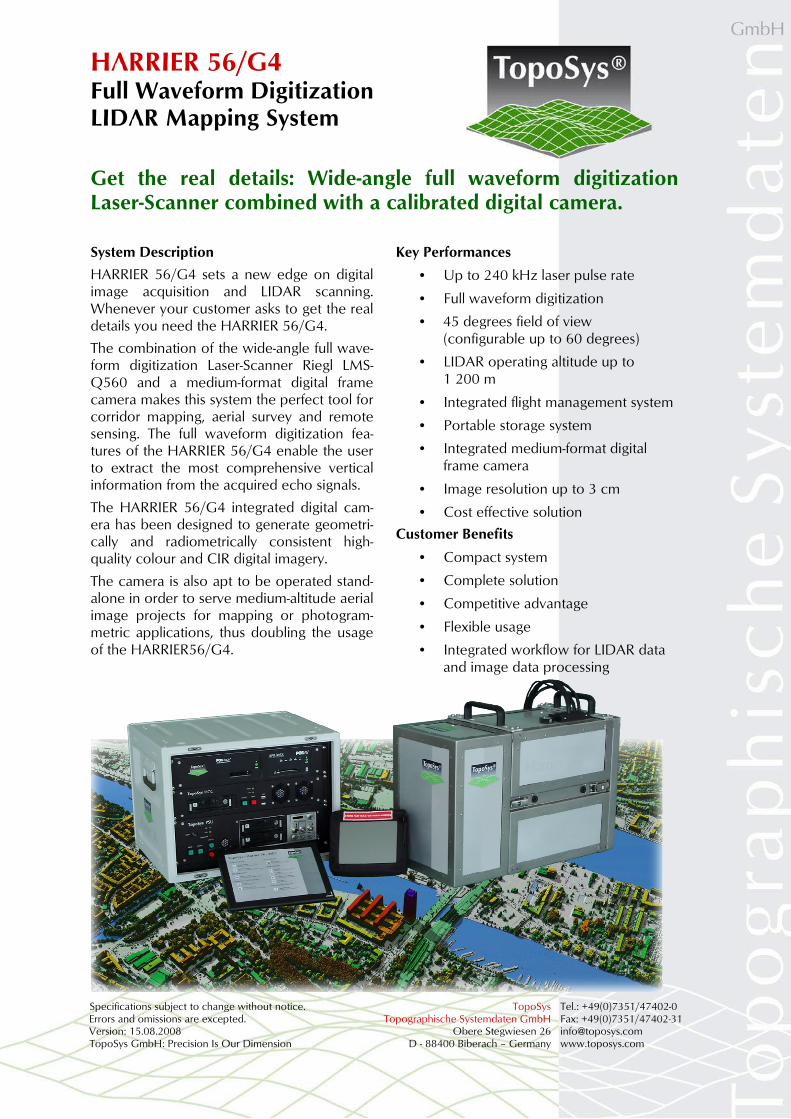
HARRIER 56/G4 Full Waveform Digitization LIDAR Mapping System
Specifications subject to change without notice. TopoSys Tel.: +49(0)7351/47402-0 Errors and omissions are excepted. Topographische Systemdaten GmbH Fax: +49(0)7351/47402-31 Version: 15.08.2008 Obere Stegwiesen 26 [email protected] TopoSys GmbH: Precision Is Our Dimension D - 88400 Biberach – Germany www.toposys.com
Get the real details: Wide-angle full waveform digitization Laser-Scanner combined with a calibrated digital camera.
System Description
HARRIER 56/G4 sets a new edge on digital image acquisition and LIDAR scanning. Whenever your customer asks to get the real details you need the HARRIER 56/G4.
The combination of the wide-angle full wave-form digitization Laser-Scanner Riegl LMS-Q560 and a medium-format digital frame camera makes this system the perfect tool for corridor mapping, aerial survey and remote sensing. The full waveform digitization fea-tures of the HARRIER 56/G4 enable the user to extract the most comprehensive vertical information from the acquired echo signals.
The HARRIER 56/G4 integrated digital cam-era has been designed to generate geometri-cally and radiometrically consistent high-quality colour and CIR digital imagery.
The camera is also apt to be operated stand-alone in order to serve medium-altitude aerial image projects for mapping or photogram-metric applications, thus doubling the usage of the HARRIER56/G4.
Key Performances
• Up to 240 kHz laser pulse rate
• Full waveform digitization
• 45 degrees field of view (configurable up to 60 degrees)
• LIDAR operating altitude up to 1 200 m
• Integrated flight management system
• Portable storage system
• Integrated medium-format digital frame camera
• Image resolution up to 3 cm
• Cost effective solution
Customer Benefits
• Compact system
• Complete solution
• Competitive advantage
• Flexible usage
• Integrated workflow for LIDAR data and image data processing
HARRIER 56/G4 Full Waveform Digitization LIDAR Mapping System
Specifications subject to change without notice. TopoSys Tel.: +49(0)7351/47402-0 Errors and omissions excepted. Topographische Systemdaten GmbH Fax: +49(0)7351/47402-31 Version: 15.08.2008 Obere Stegwiesen 26 [email protected] TopoSys GmbH: Precision Is Our Dimension D - 88400 Biberach – Germany www.toposys.com
Sensor Head Specifications
Laser scanner: Riegl LMS-Q560
Beam deflection: Rotating polygon
Field of view: 45 degrees to 60 degrees (max)
Measurement rate: 120 000 Hz (45deg.) 160 000 Hz (60deg.)
Operating altitude: 30 m – 1 200 m
Beam divergence: 0.5 mrad
Range capture: Full waveform digitization
Intensity capture: 16 bit
Scan frequency: 10 Hz to 160 Hz
Eye safety class: Class 1
Swath width: 83 % of op. altitude (45 degrees)
Range resolution: 0.020 m
Vertical accuracy: < 0.15 m (absolute)
Horizontal accuracy: < 0.25 m (absolute)
Scan pattern: Parallel lines
Temperature: 0 – +40 °C (operation)
-10 – +50 °C (storage)
Humidity: 0 % – 90 % Non-condensing
Weight : 32 kg (+10 camera)
Dimensions sensor: 64 × 30 × 48 cm
Vibration isolated case mounts directly on the aircraft floor
Available options: Integrated medium- format digital frame camera
Integrated flight management system
Portable storage system
Digital Camera Specifications (Option)
Model: Applanix DSS or Rollei Metric AIC Pro
Operating altitude: 0 – 6 000 m
Field of view: 45 degrees (60 opt.)
Array size: 22 / 39 MP
Channels: Three (RGB or IGB)
Max. Exp. rate: Down to 2.5 sec.
Image pixel size: Down to 0.03 m
Image scales: 1:250 to 1:10 000
Calibration: Geometrical and Radiometrical
Computer Rack Specifications
Log time: > 8 h
Power: 28 V DC, 20 A max. Temperature: 0 – +40 °C (operation)
-10 – +50 °C (storage)
Humidity: 0 % – 90% Non-condensing
Positioning system: Applanix POS/AV Novatel SPAN
Weight : 42 kg
Dimensions computer: 54 × 50 × 44 cm
Vibration isolated case mounts directly on the aircraft floor
Operations and Applications
Corridor mapping and area mapping, aerial survey and remote sensing
All kind of high-resolution ortho images, rapid response, pipeline monitoring, power line mapping, corridor mapping, city models, common LIDAR projects, detailed analysis and studies, target classification
Helicopter and aeroplane operation
Data Processing
TopPIT software package for pre- and post- processing of LIDAR data and true-ortho images generation
Harmonized data flow and workflow for LI-DAR and imagery data