Embed Size (px)
Citation preview
Harnessing the power
of GIS
Geospatial World Forum
May 25, 2016
2
Copyright © 2016 Deloitte Development LLC. All rights reserved.
Copyright © 2016 Deloitte Development LLC. All rights reserved.
The changing geospatial landscape
Historical perspective
3
Copyright © 2016 Deloitte Development LLC. All rights reserved.
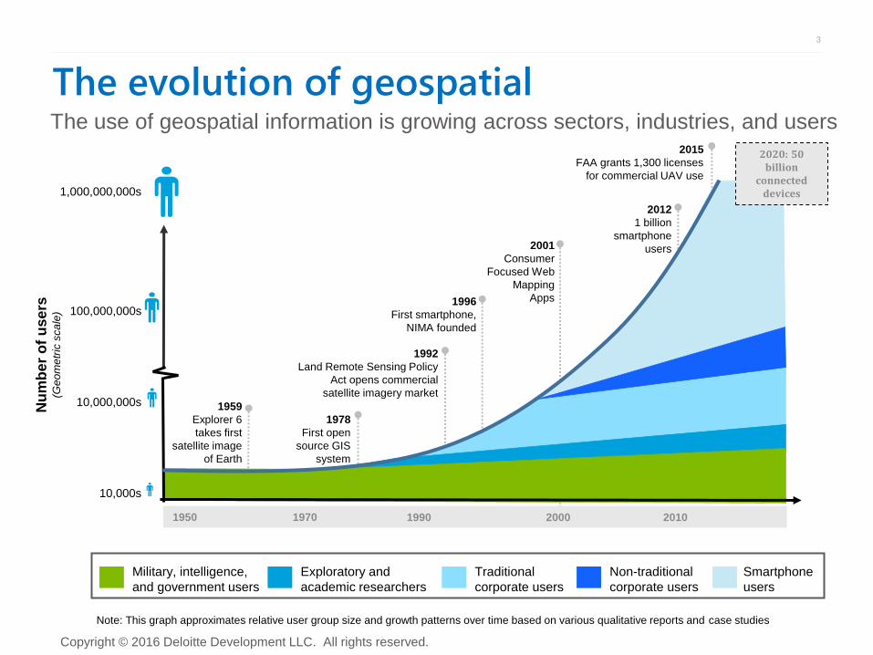
The evolution of geospatial
1978
First open
source GIS
system
1959
Explorer 6
takes first
satellite image
of Earth
Nu
mb
er
of
us
ers
(G
eo
me
tric
sca
le)
1,000,000,000s
1992
Land Remote Sensing Policy
Act opens commercial
satellite imagery market
100,000,000s
10,000s
10,000,000s
1950 1970 1990 2010 2000
1996
First smartphone,
NIMA founded
2001
Consumer
Focused Web
Mapping
Apps
2015
FAA grants 1,300 licenses
for commercial UAV use
2012
1 billion
smartphone
users
2020: 50 billion
connected devices
Military, intelligence,
and government users
Exploratory and
academic researchers
Traditional
corporate users
Non-traditional
corporate users
Smartphone
users
Note: This graph approximates relative user group size and growth patterns over time based on various qualitative reports and case studies
The use of geospatial information is growing across sectors, industries, and users
4
Copyright © 2016 Deloitte Development LLC. All rights reserved.
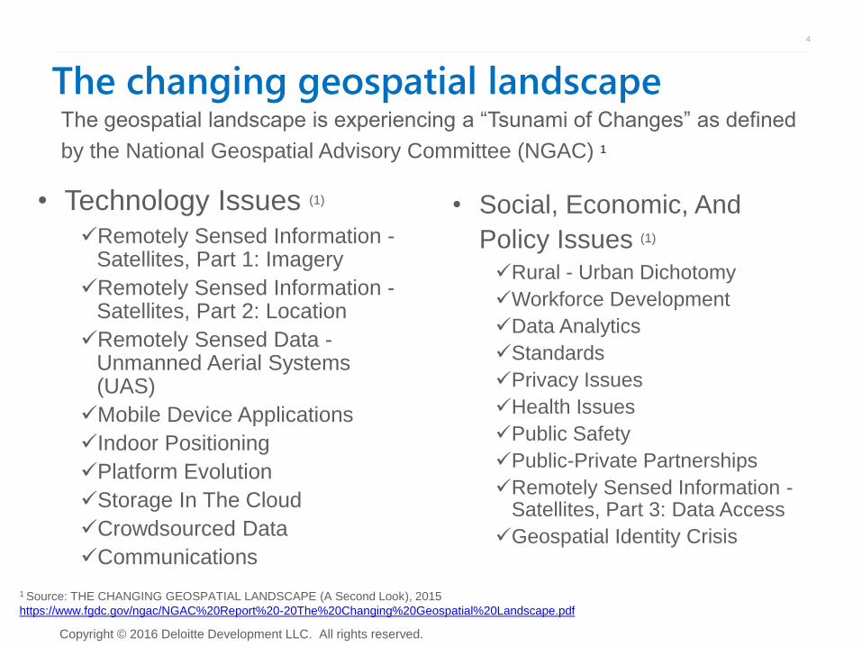
The changing geospatial landscape
• Technology Issues (1) Remotely Sensed Information -
Satellites, Part 1: Imagery
Remotely Sensed Information - Satellites, Part 2: Location
Remotely Sensed Data - Unmanned Aerial Systems (UAS)
Mobile Device Applications
Indoor Positioning
Platform Evolution
Storage In The Cloud
Crowdsourced Data
Communications
The geospatial landscape is experiencing a “Tsunami of Changes” as defined
by the National Geospatial Advisory Committee (NGAC) 1
1 Source: THE CHANGING GEOSPATIAL LANDSCAPE (A Second Look), 2015
https://www.fgdc.gov/ngac/NGAC%20Report%20-20The%20Changing%20Geospatial%20Landscape.pdf
• Social, Economic, And
Policy Issues (1)
Rural - Urban Dichotomy
Workforce Development
Data Analytics
Standards
Privacy Issues
Health Issues
Public Safety
Public-Private Partnerships
Remotely Sensed Information - Satellites, Part 3: Data Access
Geospatial Identity Crisis
5
Copyright © 2016 Deloitte Development LLC. All rights reserved.
Copyright © 2016 Deloitte Development LLC. All rights reserved.
Future trends
Location matters
6
Copyright © 2016 Deloitte Development LLC. All rights reserved.
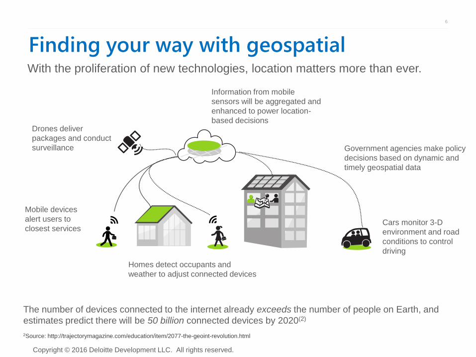
Finding your way with geospatial With the proliferation of new technologies, location matters more than ever.
Cars monitor 3-D
environment and road
conditions to control
driving
Drones deliver
packages and conduct
surveillance
Information from mobile
sensors will be aggregated and
enhanced to power location-
based decisions
Mobile devices
alert users to
closest services
Homes detect occupants and
weather to adjust connected devices
Government agencies make policy
decisions based on dynamic and
timely geospatial data
The number of devices connected to the internet already exceeds the number of people on Earth, and
estimates predict there will be 50 billion connected devices by 2020(2)
2Source: http://trajectorymagazine.com/education/item/2077-the-geoint-revolution.html
7
Copyright © 2016 Deloitte Development LLC. All rights reserved.
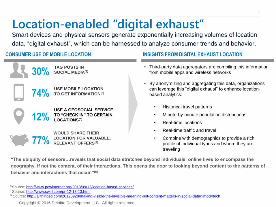
Location-enabled “digital exhaust” Smart devices and physical sensors generate exponentially increasing volumes of location
data, “digital exhaust”, which can be harnessed to analyze consumer trends and behavior.
TAG POSTS IN
SOCIAL MEDIA(3) 30%
USE MOBILE LOCATION
TO GET INFORMATION(3) 74%
USE A GEOSOCIAL SERVICE
TO “CHECK IN” TO CERTAIN
LOCATIONS(3) 12%
WOULD SHARE THEIR
LOCATION FOR VALUABLE,
RELEVANT OFFERS(4) 77%
“The ubiquity of sensors…reveals that social data stretches beyond individuals’ online lives to encompass the
geography, if not the content, of their interactions. This opens the door to looking beyond content to the patterns of
behavior and interactions that occur.”(5)
• Historical travel patterns
• Minute-by-minute population distributions
• Real-time locations
• Real-time traffic and travel
• Combine with demographics to provide a rich
profile of individual types and where they are
traveling
• Third-party data aggregators are compiling this information
from mobile apps and wireless networks
• By anonymizing and aggregating this data, organizations
can leverage this “digital exhaust” to enhance location-
based analytics:
CONSUMER USE OF MOBILE LOCATION INSIGHTS FROM DIGITAL EXHAUST LOCATION
3 Source: http://www.pewinternet.org/2013/09/12/location-based-services/ 4 Source: http://www.swirl.com/pr-12-13-13.html 5 Source: http://allthingsd.com/20120928/making-visible-the-invisible-meaning-not-content-matters-in-social-data/?mod=tech
8
Copyright © 2016 Deloitte Development LLC. All rights reserved.
Copyright © 2016 Deloitte Development LLC. All rights reserved.
Economic impact
Markets and industries
9
Copyright © 2016 Deloitte Development LLC. All rights reserved.
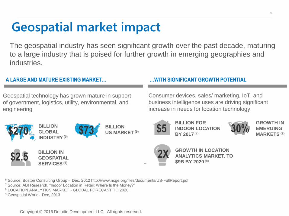
Geospatial technology has grown mature in support
of government, logistics, utility, environmental, and
engineering
A LARGE AND MATURE EXISTING MARKET… …WITH SIGNIFICANT GROWTH POTENTIAL
BILLION
GLOBAL
INDUSTRY (9)
Consumer devices, sales/ marketing, IoT, and
business intelligence uses are driving significant
increase in needs for location technology
6 Source: Boston Consulting Group - Dec, 2012 http://www.ncge.org/files/documents/US-FullReport.pdf 7 Source: ABI Research, “Indoor Location in Retail: Where Is the Money?” 8 LOCATION ANALYTICS MARKET - GLOBAL FORECAST TO 2020 9 Geospatial World- Dec, 2013
BILLION FOR
INDOOR LOCATION
BY 2017 (7) $270
The geospatial industry has seen significant growth over the past decade, maturing
to a large industry that is poised for further growth in emerging geographies and
industries.
$73 BILLION
US MARKET (9) $5 GROWTH IN
EMERGING
MARKETS (9) 30%
2X GROWTH IN LOCATION
ANALYTICS MARKET, TO
$9B BY 2020 (8)
BILLION IN
GEOSPATIAL
SERVICES (6) $2.5
Geospatial market impact
10
Copyright © 2016 Deloitte Development LLC. All rights reserved.
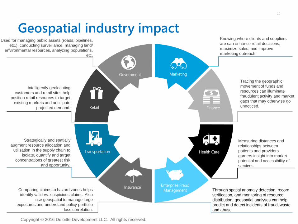
Geospatial industry impact
Strategically and spatially
augment resource allocation and
utilization in the supply chain to
isolate, quantify and target
concentrations of greatest risk
and opportunity.
Comparing claims to hazard zones helps
identify valid vs. suspicious claims. Also
use geospatial to manage large
exposures and understand policy portfolio
loss correlation.
Measuring distances and
relationships between
patients and providers
garners insight into market
potential and accessibility of
services
Tracing the geographic
movement of funds and
resources can illuminate
fraudulent activity and market
gaps that may otherwise go
unnoticed.
Through spatial anomaly detection, record
verification, and monitoring of resource
distribution, geospatial analyses can help
predict and detect incidents of fraud, waste
and abuse
Knowing where clients and suppliers
are can enhance retail decisions,
maximize sales, and improve
marketing outreach.
Intelligently geolocating
customers and retail sites help
position retail resources to target
existing markets and anticipate
projected demand.
Enterprise Fraud
Management
Health Care
Marketing
Finance
Transportation
Insurance
Retail
Government
Used for managing public assets (roads, pipelines,
etc.), conducting surveillance, managing land/
environmental resources, analyzing populations,
etc.
11
Copyright © 2016 Deloitte Development LLC. All rights reserved.
Copyright © 2016 Deloitte Development LLC. All rights reserved.
Featured use case
Data USA project
12
Copyright © 2016 Deloitte Development LLC. All rights reserved.
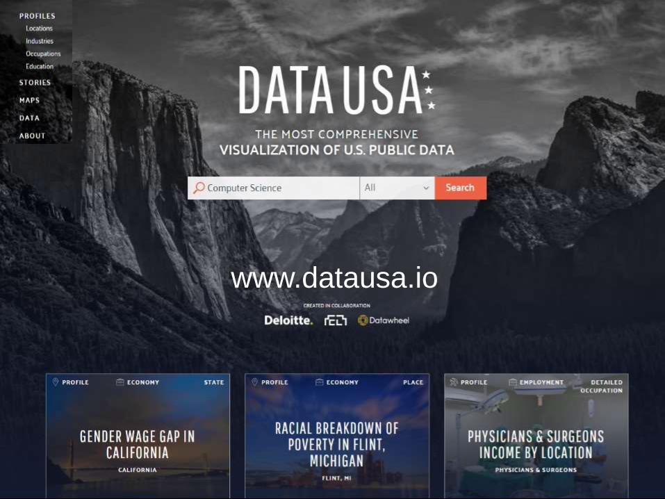
www.datausa.io
13
Copyright © 2016 Deloitte Development LLC. All rights reserved.
Tell a new story • Public data holds insights that can inform choices, direct action, and create
impact. The US government collects, stores, and makes available enormous
amounts of data which is too often siloed, difficult to access, and hard to
understand
• To help deliver those insights in a visual, interactive way, specialists from
Deloitte, MIT Media Lab’s Micro Connections Group, and Datawheel jointly
created Data USA -- a destination and visualization engine that retrieves data
from various US government data sources, organizes and analyzes it, and
helps you visualize the answers you’re looking for in seconds.
• Data USA presents consolidated views of useful data on a wide range of
topics, including:
Labor and Job Markets
Higher Education
Regional Demographics
Health Care
Transportation
14
Copyright © 2016 Deloitte Development LLC. All rights reserved.
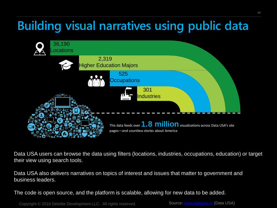
Building visual narratives using public data
Data USA users can browse the data using filters (locations, industries, occupations, education) or target
their view using search tools.
Data USA also delivers narratives on topics of interest and issues that matter to government and
business leaders.
The code is open source, and the platform is scalable, allowing for new data to be added.
Source: www.datausa.io (Data USA)
This data feeds over 1.8 million visualizations across Data USA’s site pages—and countless
stories about America
2,319
Higher Education Majors
301
Industries
525
Occupations
36,190
Locations
This data feeds over 1.8 million visualizations across Data USA’s site
pages—and countless stories about America
15
Copyright © 2016 Deloitte Development LLC. All rights reserved.
Questions?
Bagrat Bayburtian
Deloitte Advisory Director Deloitte Transactions and Business Analytics LLP
Email: [email protected]
16
Copyright © 2016 Deloitte Development LLC. All rights reserved.
This presentation contains general information only and Deloitte Advisory is not, by means of this presentation, rendering accounting, business, financial,
investment, legal, tax, or other professional advice or services. This presentation is not a substitute for such professional advice or services, nor should it be
used as a basis for any decision or action that may affect your business. Before making any decision or taking any action that may affect your business, you
should consult a qualified professional advisor. Deloitte Advisory shall not be responsible for any loss sustained by any person who relies on this presentation.
As used in this document, “Deloitte Advisory” means Deloitte & Touche LLP, which provides audit and enterprise risk services; Deloitte F inancial Advisory
Services LLP, which provides forensic, dispute, and other consulting services; and its affiliate, Deloitte Transactions and Business Analytics LLP, which
provides a wide range of advisory and analytics services. Deloitte Transactions and Business Analytics LLP is not a certified public accounting firm. These
entities are separate subsidiaries of Deloitte LLP. Please see www.deloitte.com/us/about for a detailed description of the legal structure of Deloitte LLP and its
subsidiaries. Certain services may not be available to attest clients under the rules and regulations of public accounting.