Embed Size (px)
Citation preview
FAMOS Activity 2
Harmonising vertical datum (FAMOS Freja)
BSHC CDWG meeting, Ålborg, 5-6 February, 2019
FAMOS Activity 2
Improving vessel navigation for the future
(FAMOS Odin)
FAMOS Activity 2
Harmonising vertical datum/
Improving vessel navigation for the future
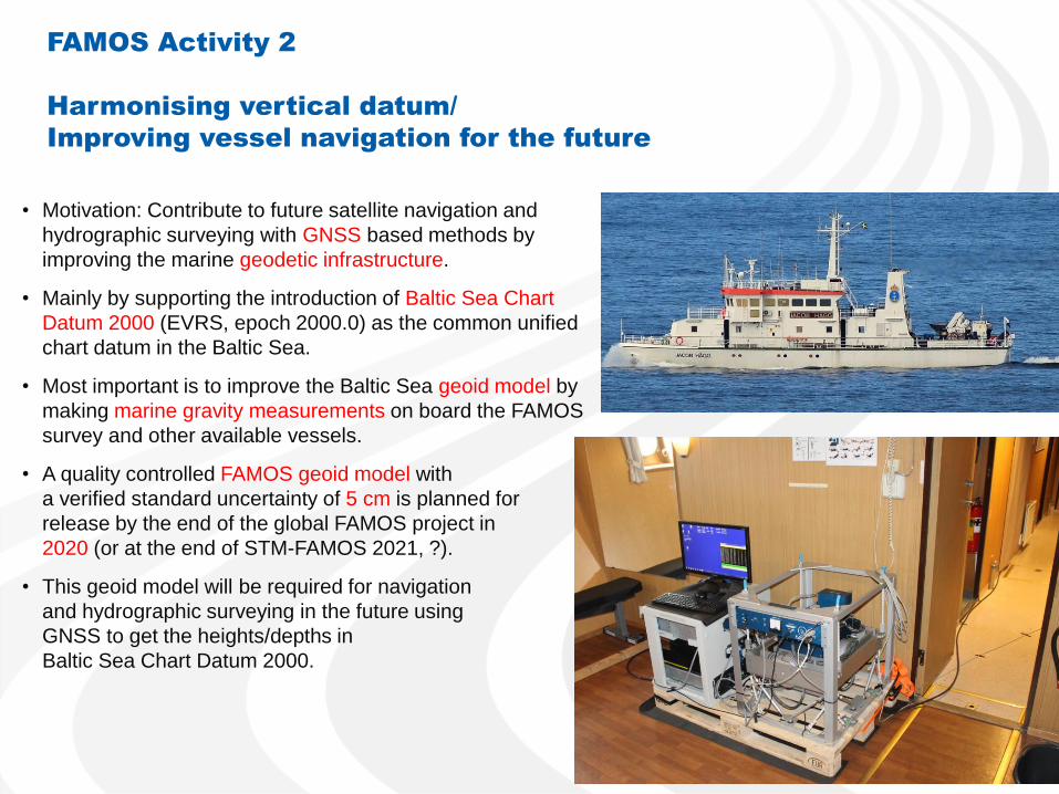
• Motivation: Contribute to future satellite navigation and
hydrographic surveying with GNSS based methods by
improving the marine geodetic infrastructure.
• Mainly by supporting the introduction of Baltic Sea Chart
Datum 2000 (EVRS, epoch 2000.0) as the common unified
chart datum in the Baltic Sea.
• Most important is to improve the Baltic Sea geoid model by
making marine gravity measurements on board the FAMOS
survey and other available vessels.
• A quality controlled FAMOS geoid model with
a verified standard uncertainty of 5 cm is planned for
release by the end of the global FAMOS project in
2020 (or at the end of STM-FAMOS 2021, ?).
• This geoid model will be required for navigation
and hydrographic surveying in the future using
GNSS to get the heights/depths in
Baltic Sea Chart Datum 2000.
Subactivities in FAMOS Odin Activity 2
2.1 Shipborne gravimetry measurements and processing
2.2 Creation/maintenance of databases, gravimetry data analyses/updates and
geoid computations
2.3 Mean Sea Surface modelling and water level control (tide gauges, altimetry)
2.4 Shipborne GNSS for precision navigation and geoid evaluation at sea
2.5 Change of chart datum in Sweden and Finland
2.6 Vessel routing with optimised UKC and fuel efficiency
Status in FAMOS Odin Sub-activity
2.1-2.2 (Gravity and geoid)
BSHC CDWG meeting, Ålborg, 5-6 February, 2019
Jonas Ågren, Joachim Schwabe, Gabriel Strykowski, Christoph Förste,
Sinem Ince, Per-Anders Olsson, Mirjam Bilker-Koivula, Artu Ellmann,
Franz Barthelmes, René Forsberg, Gunter Liebsch, Janis Kaminskis, …
Sub-activity 2.1 - Shipborne gravimetry measurements
and processing
• Shipborne marine gravimetry measurements
• Processing and delivery of final gravity values to the FAMOS database
• The above tasks also includes :
– Solution of legal question, permissions, etc.
– Coordination, planning and preparation of campaigns
– Determination of gravity values on land for the harbour ties
– Development of software for marine processing
– Education of personnel
• Procurement of a marine gravimeter for LM, putting it into service and
development of digital production line
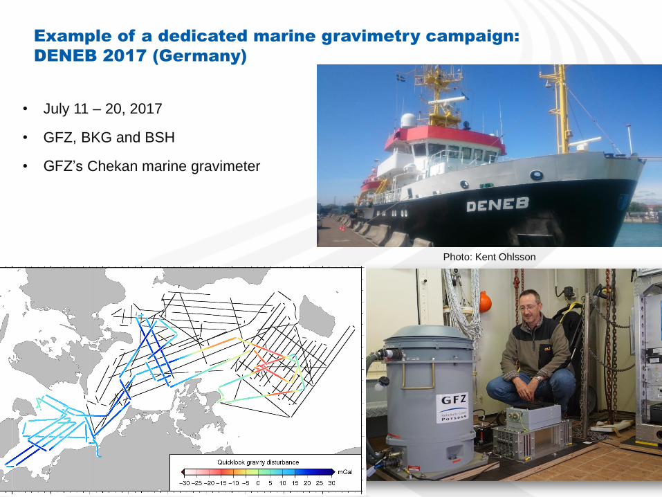
Photo: Kent Ohlsson
Example of a dedicated marine gravimetry campaign:
DENEB 2017 (Germany)
• July 11 – 20, 2017
• GFZ, BKG and BSH
• GFZ’s Chekan marine gravimeter
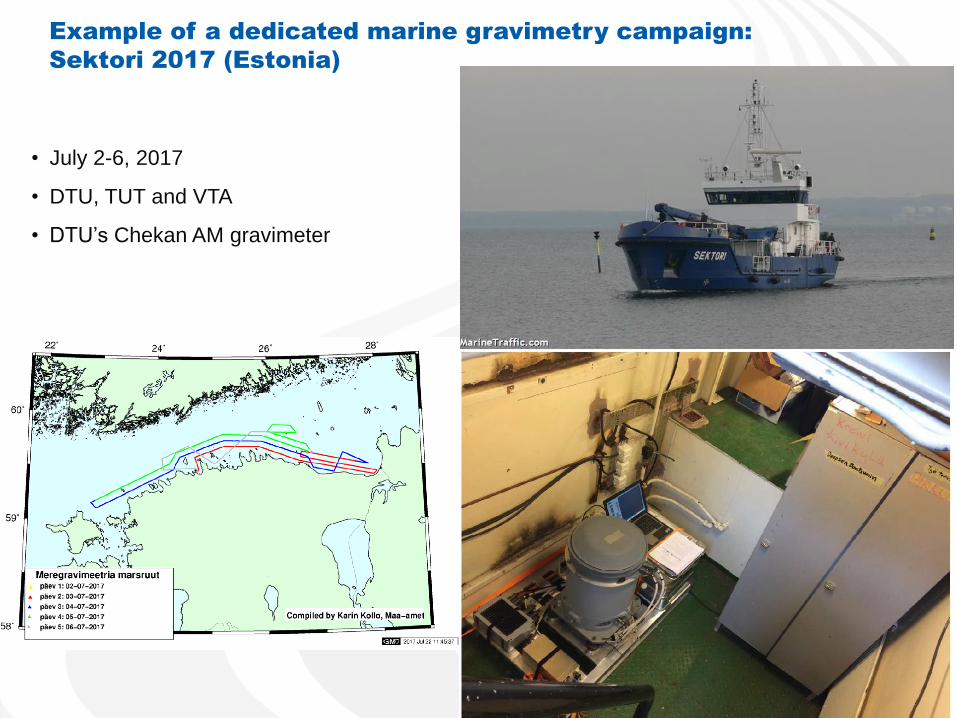
Example of a dedicated marine gravimetry campaign:
Sektori 2017 (Estonia)
• July 2-6, 2017
• DTU, TUT and VTA
• DTU’s Chekan AM gravimeter
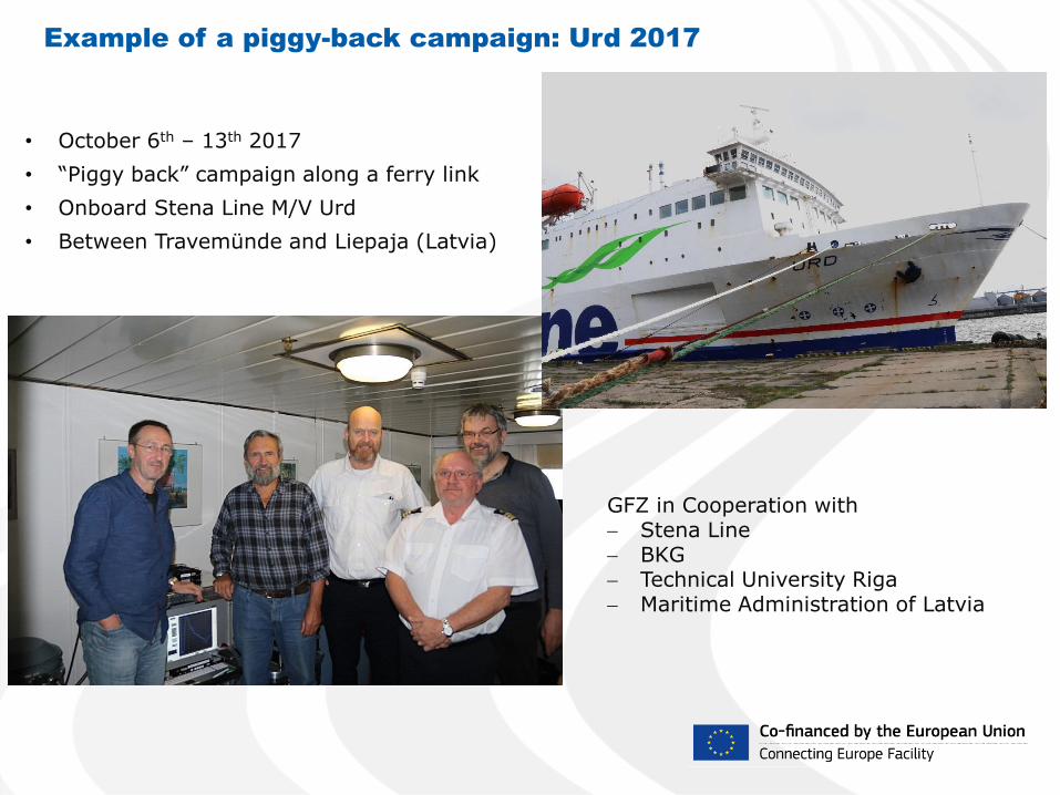
Example of a piggy-back campaign: Urd 2017
• October 6th – 13th 2017
• “Piggy back” campaign along a ferry link
• Onboard Stena Line M/V Urd
• Between Travemünde and Liepaja (Latvia)
GFZ in Cooperation with Stena Line BKG Technical University Riga Maritime Administration of Latvia
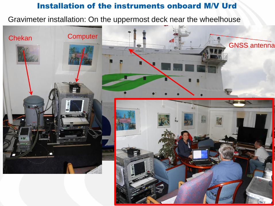
Gravimeter installation: On the uppermost deck near the wheelhouse
Installation of the instruments onboard M/V Urd
Chekan Computer
GNSS antenna

Marine gravimetry campaigns in FAMOS • Deneb 2015
• Airisto 2015
• Jacob Hägg 2015
• Jens Sørensen 2015
• Deneb 2016
• Jacob Prei 2016
• Jacob Hägg 2016
• Jens Sørensen 2016
• Deneb 2017
• Sektori 2017
• Jacob Hägg 2017a
• Jacob Hägg 2017b
• Jens Sørensen 2017
• Urd 2017
• Deneb 2018
• Jakob Hägg 2018
• Geomari 2018
• Fyrbyggaren 2018a,b
• Jens Sørensen 2018
• Finnlady 2018
• Kattegatt 2018* (airborne)
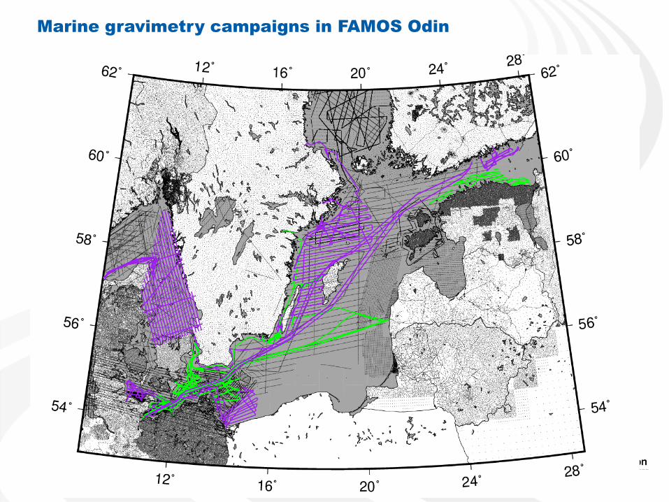
Marine gravimetry campaigns in FAMOS Odin
Sub-activity 2.2 – Maintenance of databases, gravity
data analysis/updates and geoid computations
• Maintain and update the FAMOS gravity database with new FAMOS
marine data.
– Also work to get access gravity data from the now empty land areas,
sign exchange agreements as needed
• Maintain the FAMOS GNSS/levelling database
• Use the new FAMOS marine gravity data to analyse the existing
(pre-FAMOS) data and compare with other types of data
• FAMOS interim geoid computation using different methods and strategies
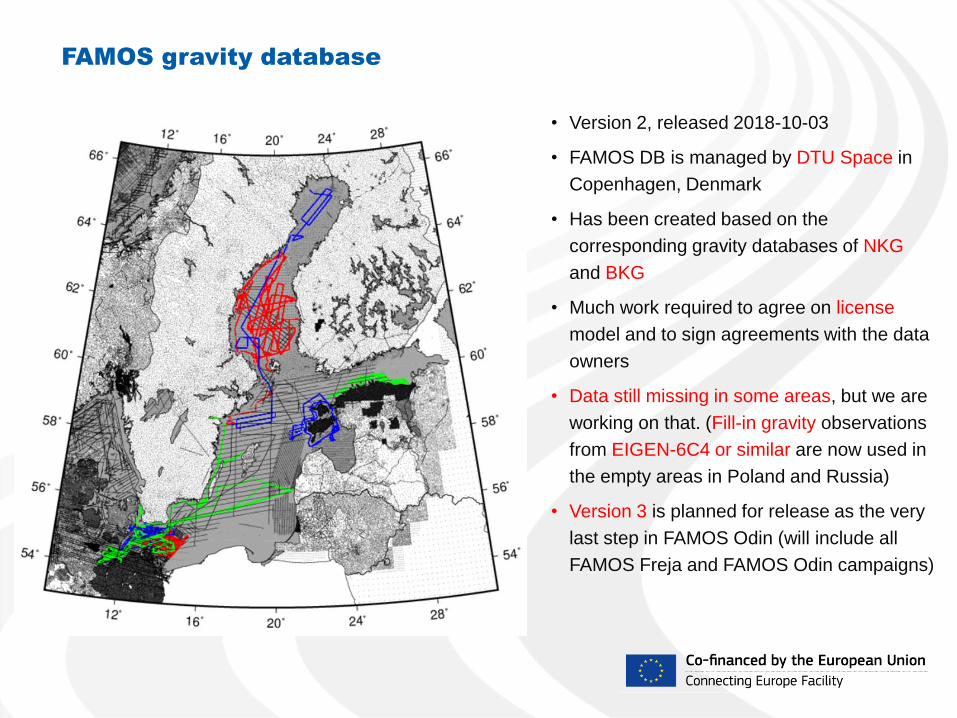
FAMOS gravity database
• Version 2, released 2018-10-03
• FAMOS DB is managed by DTU Space in
Copenhagen, Denmark
• Has been created based on the
corresponding gravity databases of NKG
and BKG
• Much work required to agree on license
model and to sign agreements with the data
owners
• Data still missing in some areas, but we are
working on that. (Fill-in gravity observations
from EIGEN-6C4 or similar are now used in
the empty areas in Poland and Russia)
• Version 3 is planned for release as the very
last step in FAMOS Odin (will include all
FAMOS Freja and FAMOS Odin campaigns)
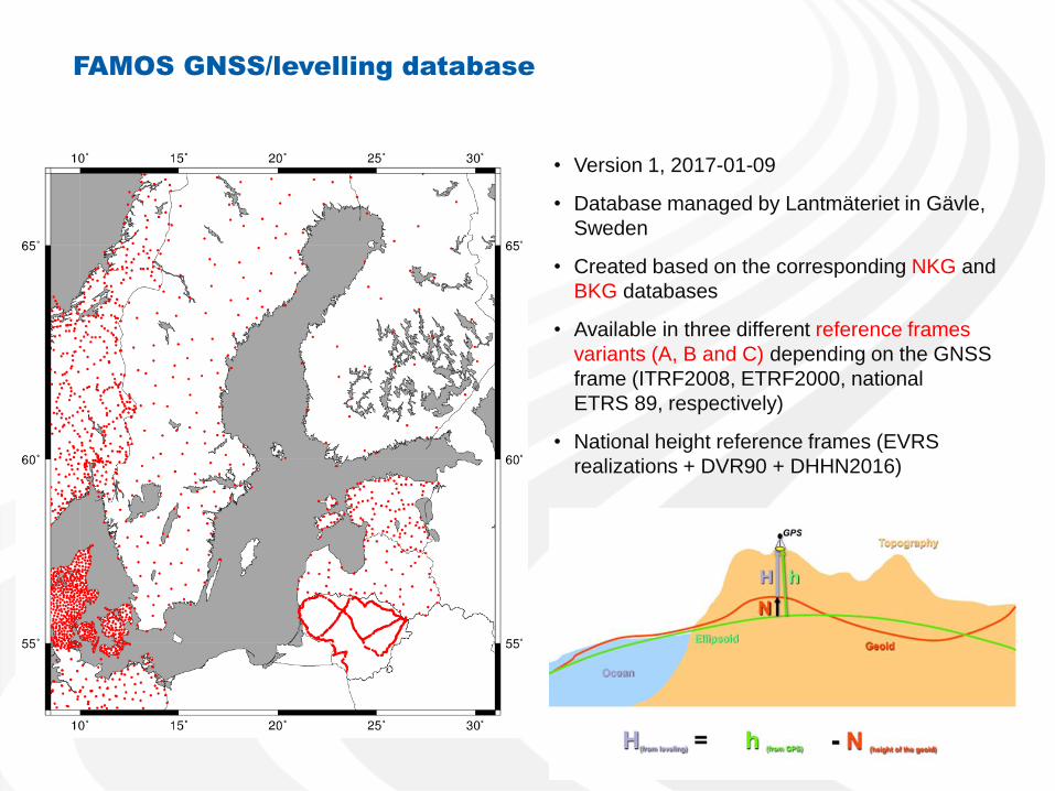
FAMOS GNSS/levelling database
• Version 1, 2017-01-09
• Database managed by Lantmäteriet in Gävle,
Sweden
• Created based on the corresponding NKG and
BKG databases
• Available in three different reference frames
variants (A, B and C) depending on the GNSS
frame (ITRF2008, ETRF2000, national
ETRS 89, respectively)
• National height reference frames (EVRS
realizations + DVR90 + DHHN2016)
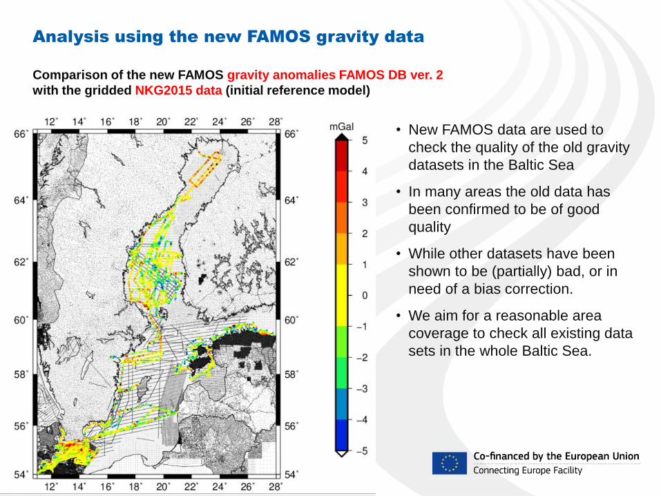
Analysis using the new FAMOS gravity data
• New FAMOS data are used to
check the quality of the old gravity
datasets in the Baltic Sea
• In many areas the old data has
been confirmed to be of good
quality
• While other datasets have been
shown to be (partially) bad, or in
need of a bias correction.
• We aim for a reasonable area
coverage to check all existing data
sets in the whole Baltic Sea.
Comparison of the new FAMOS gravity anomalies FAMOS DB ver. 2
with the gridded NKG2015 data (initial reference model)

Difference between new FAMOS data (in DB version 2)
and the data of the initial reference model NKG2015
FAMOS interim geoid model LM6a (using
ver. 2) minus NKG2015 geoid model (m)
New FAMOS surface gravity anomalies in ver. 2
minus gridded NKG2015
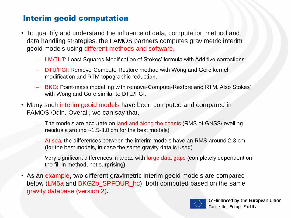
Interim geoid computation
• To quantify and understand the influence of data, computation method and
data handling strategies, the FAMOS partners computes gravimetric interim
geoid models using different methods and software,
– LM/TUT: Least Squares Modification of Stokes’ formula with Additive corrections.
– DTU/FGI: Remove-Compute-Restore method with Wong and Gore kernel
modification and RTM topographic reduction.
– BKG: Point-mass modelling with remove-Compute-Restore and RTM. Also Stokes’
with Wong and Gore similar to DTU/FGI.
• Many such interim geoid models have been computed and compared in
FAMOS Odin. Overall, we can say that,
– The models are accurate on land and along the coasts (RMS of GNSS/levelling
residuals around ~1.5-3.0 cm for the best models)
– At sea, the differences between the interim models have an RMS around 2-3 cm
(for the best models, in case the same gravity data is used)
– Very significant differences in areas with large data gaps (completely dependent on
the fill-in method, not surprising)
• As an example, two different gravimetric interim geoid models are compared
below (LM6a and BKG2b_SPFOUR_hc), both computed based on the same
gravity database (version 2).
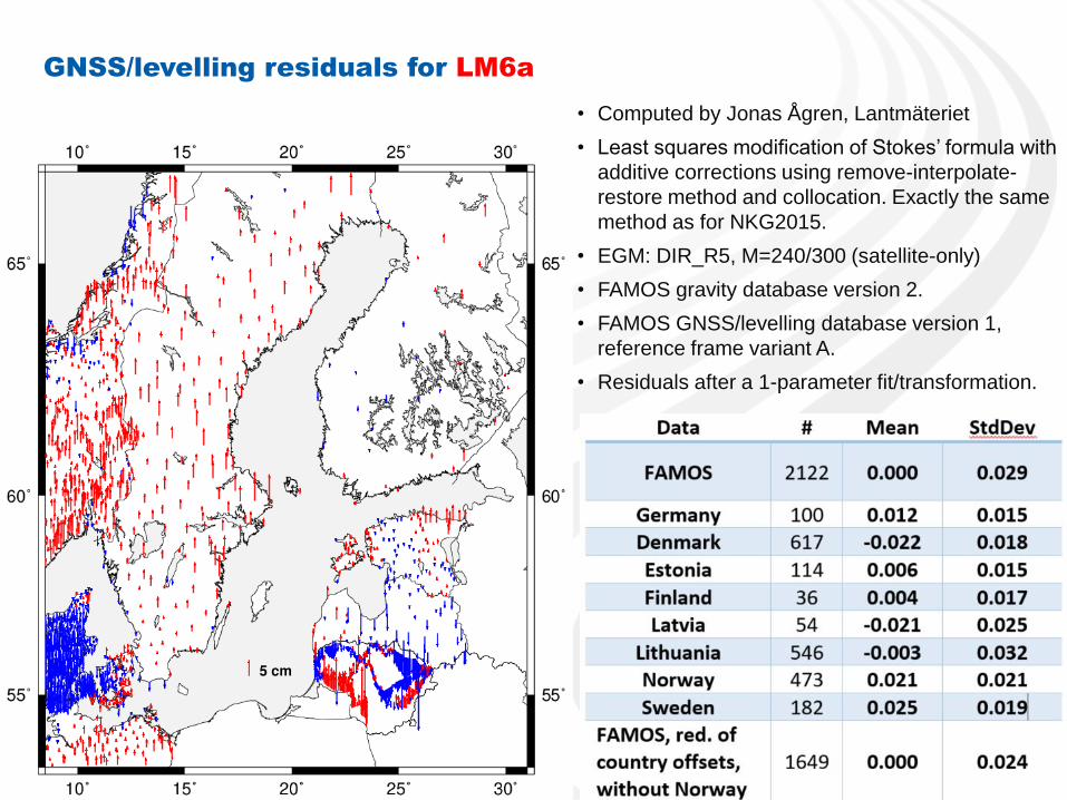
GNSS/levelling residuals for LM6a
• Computed by Jonas Ågren, Lantmäteriet
• Least squares modification of Stokes’ formula with
additive corrections using remove-interpolate-
restore method and collocation. Exactly the same
method as for NKG2015.
• EGM: DIR_R5, M=240/300 (satellite-only)
• FAMOS gravity database version 2.
• FAMOS GNSS/levelling database version 1,
reference frame variant A.
• Residuals after a 1-parameter fit/transformation.
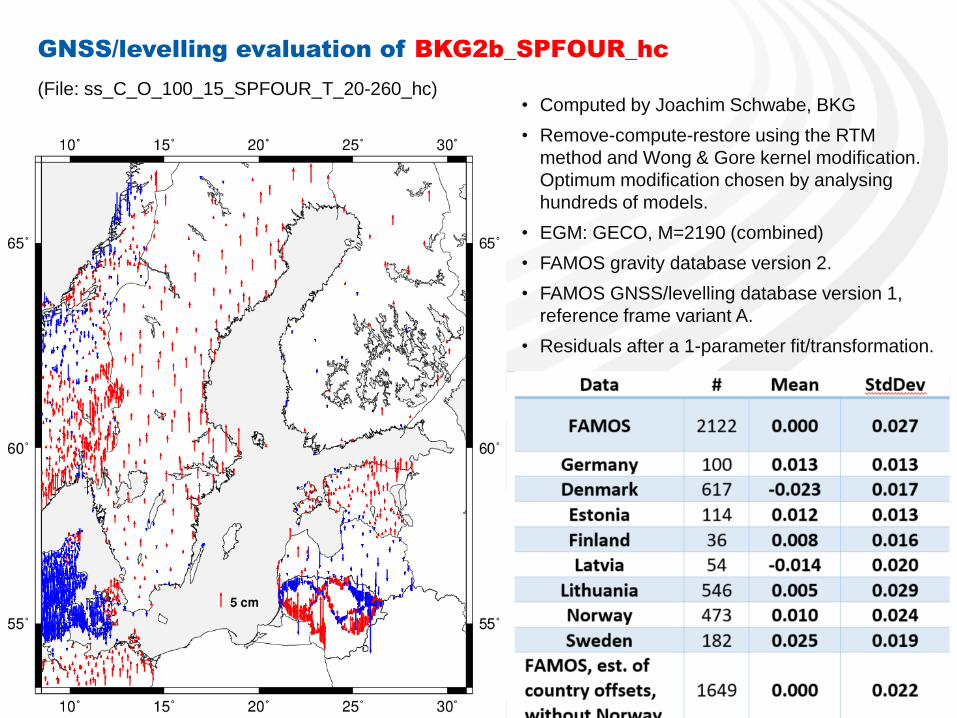
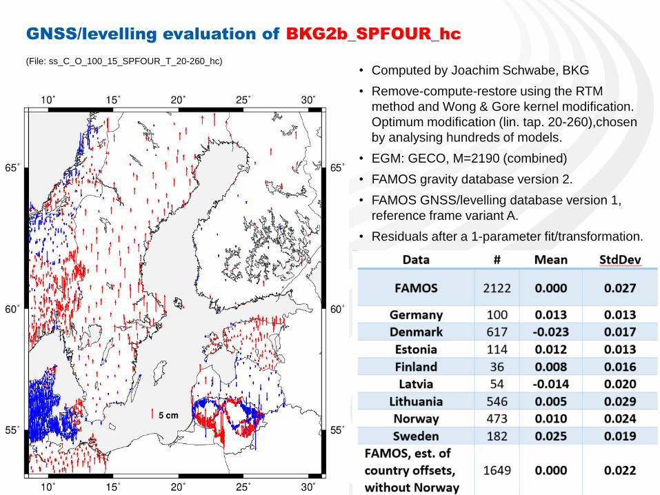
GNSS/levelling evaluation of BKG2b_SPFOUR_hc
• Computed by Joachim Schwabe, BKG
• Remove-compute-restore using the RTM
method and Wong & Gore kernel modification.
Optimum modification chosen by analysing
hundreds of models.
• EGM: GECO, M=2190 (combined)
• FAMOS gravity database version 2.
• FAMOS GNSS/levelling database version 1,
reference frame variant A.
• Residuals after a 1-parameter fit/transformation.
(File: ss_C_O_100_15_SPFOUR_T_20-260_hc)
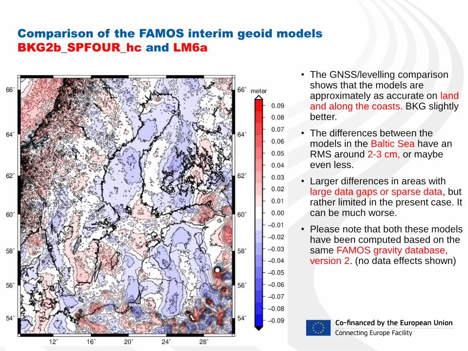
Comparison of the FAMOS interim geoid models
BKG2b_SPFOUR_hc and LM6a
• The GNSS/levelling comparison shows that the models are approximately as accurate on land and along the coasts. BKG slightly better.
• The differences between the models in the Baltic Sea have an RMS around 2-3 cm, or maybe even less.
• Larger differences in areas with large data gaps or sparse data, but rather limited in the present case. It can be much worse.
• Please note that both these models have been computed based on the same FAMOS gravity database, version 2. (no data effects shown)
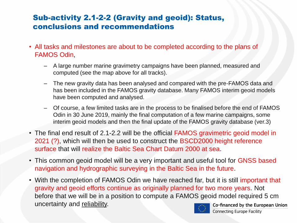
Sub-activity 2.1-2-2 (Gravity and geoid): Status,
conclusions and recommendations
• All tasks and milestones are about to be completed according to the plans of
FAMOS Odin,
– A large number marine gravimetry campaigns have been planned, measured and
computed (see the map above for all tracks).
– The new gravity data has been analysed and compared with the pre-FAMOS data and
has been included in the FAMOS gravity database. Many FAMOS interim geoid models
have been computed and analysed.
– Of course, a few limited tasks are in the process to be finalised before the end of FAMOS
Odin in 30 June 2019, mainly the final computation of a few marine campaigns, some
interim geoid models and then the final update of the FAMOS gravity database (ver.3)
• The final end result of 2.1-2.2 will be the official FAMOS gravimetric geoid model in
2021 (?), which will then be used to construct the BSCD2000 height reference
surface that will realize the Baltic Sea Chart Datum 2000 at sea.
• This common geoid model will be a very important and useful tool for GNSS based
navigation and hydrographic surveying in the Baltic Sea in the future.
• With the completion of FAMOS Odin we have reached far, but it is still important that
gravity and geoid efforts continue as originally planned for two more years. Not
before that we will be in a position to compute a FAMOS geoid model required 5 cm
uncertainty and reliability.
Marine gravimetry campaigns in FAMOS • Deneb 2015
• Airisto 2015
• Jacob Hägg 2015
• Jens Sørensen 2015
• Deneb 2016
• Jacob Prei 2016
• Jacob Hägg 2016
• Jens Sørensen 2016
• Deneb 2017
• Sektori 2017
• Jacob Hägg 2017a
• Jacob Hägg 2017b
• Jens Sørensen 2017
• Urd 2017
• Deneb 2018
• Jakob Hägg 2018
• Geomari 2018
• Fyrbyggaren 2018a,b
• Jens Sørensen 2018
• Finnlady 2018
• Kattegatt 2018* (airborne)

FAMOS gravity database
• Version 2, released 2018-10-03
• FAMOS DB is managed by DTU Space in
Copenhagen, Denmark
• Has been created based on the
corresponding gravity databases of NKG
and BKG
• Much work required to agree on license
model and to sign agreements with the data
owners
• Data still missing in some areas, but we are
working on that. (Fill-in gravity observations
from EIGEN-6C4 or similar are now used in
the empty areas in Poland and Russia)
• Version 3 is planned for release as the very
last step in FAMOS Odin (will include all
FAMOS Freja and FAMOS Odin campaigns)
Appendix 1 -
A selection of interim geoid models
computed using FAMOS gravity
database version 2
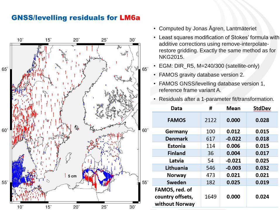
GNSS/levelling residuals for LM6a
• Computed by Jonas Ågren, Lantmäteriet
• Least squares modification of Stokes’ formula with
additive corrections using remove-interpolate-
restore gridding. Exactly the same method as for
NKG2015.
• EGM: DIR_R5, M=240/300 (satellite-only)
• FAMOS gravity database version 2.
• FAMOS GNSS/levelling database version 1,
reference frame variant A.
• Residuals after a 1-parameter fit/transformation.
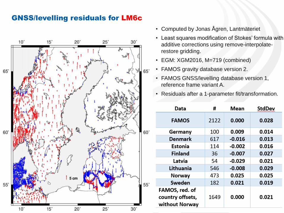
GNSS/levelling residuals for LM6c
• Computed by Jonas Ågren, Lantmäteriet
• Least squares modification of Stokes’ formula with
additive corrections using remove-interpolate-
restore gridding.
• EGM: XGM2016, M=719 (combined)
• FAMOS gravity database version 2.
• FAMOS GNSS/levelling database version 1,
reference frame variant A.
• Residuals after a 1-parameter fit/transformation.
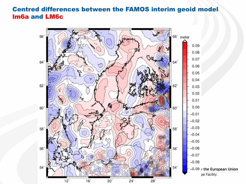
Centred differences between the FAMOS interim geoid model
lm6a and LM6c
GNSS/levelling evaluation of BKG2b_SPFOUR_hc
• Computed by Joachim Schwabe, BKG
• Remove-compute-restore using the RTM
method and Wong & Gore kernel modification.
Optimum modification (lin. tap. 20-260),chosen
by analysing hundreds of models.
• EGM: GECO, M=2190 (combined)
• FAMOS gravity database version 2.
• FAMOS GNSS/levelling database version 1,
reference frame variant A.
• Residuals after a 1-parameter fit/transformation.
(File: ss_C_O_100_15_SPFOUR_T_20-260_hc)
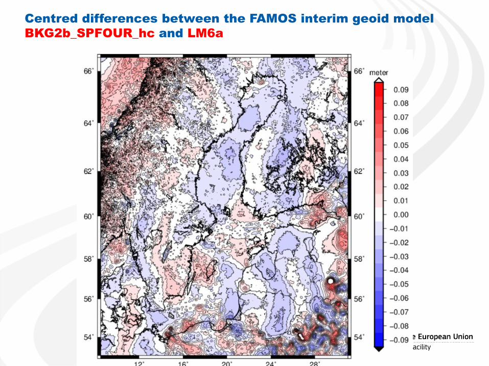
Centred differences between the FAMOS interim geoid model
BKG2b_SPFOUR_hc and LM6a
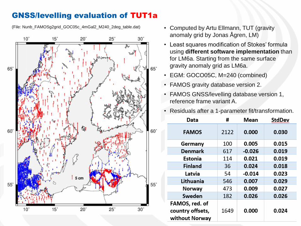
GNSS/levelling evaluation of TUT1a
• Computed by Artu Ellmann, TUT (gravity
anomaly grid by Jonas Ågren, LM)
• Least squares modification of Stokes’ formula
using different software implementation than
for LM6a. Starting from the same surface
gravity anomaly grid as LM6a.
• EGM: GOCO05C, M=240 (combined)
• FAMOS gravity database version 2.
• FAMOS GNSS/levelling database version 1,
reference frame variant A.
• Residuals after a 1-parameter fit/transformation.
(File: Nunb_FAMOSg2grid_GOC05c_4mGal2_M240_2deg_table.dat)
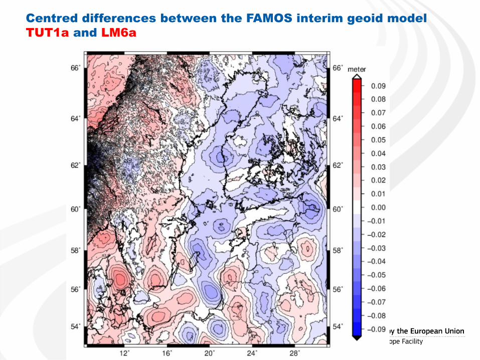
Centred differences between the FAMOS interim geoid model
TUT1a and LM6a
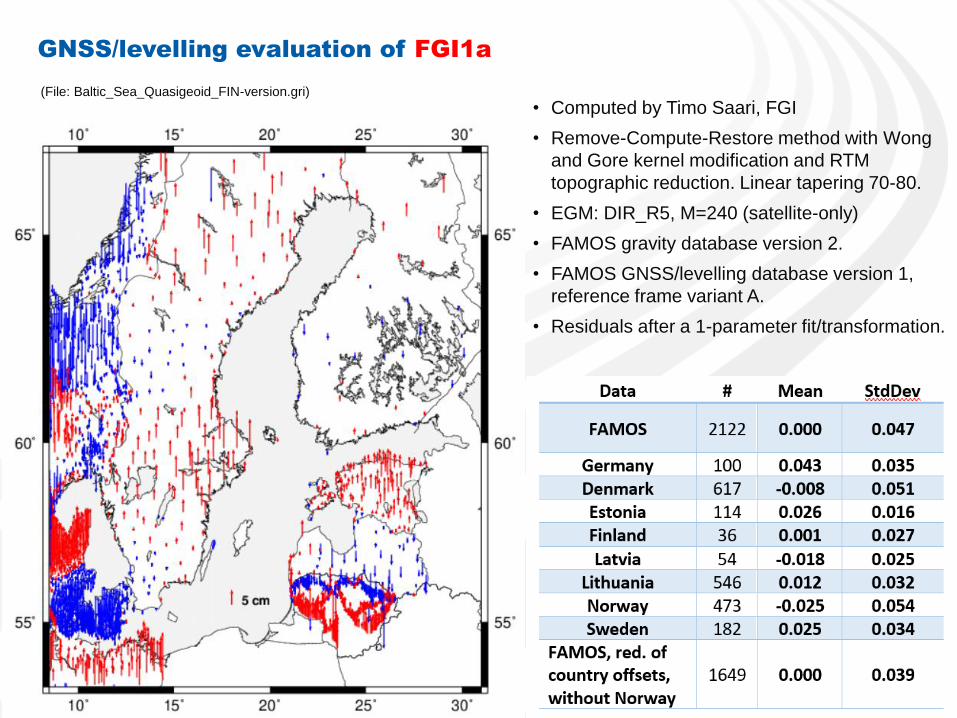
GNSS/levelling evaluation of FGI1a
• Computed by Timo Saari, FGI
• Remove-Compute-Restore method with Wong
and Gore kernel modification and RTM
topographic reduction. Linear tapering 70-80.
• EGM: DIR_R5, M=240 (satellite-only)
• FAMOS gravity database version 2.
• FAMOS GNSS/levelling database version 1,
reference frame variant A.
• Residuals after a 1-parameter fit/transformation.
(File: Baltic_Sea_Quasigeoid_FIN-version.gri)
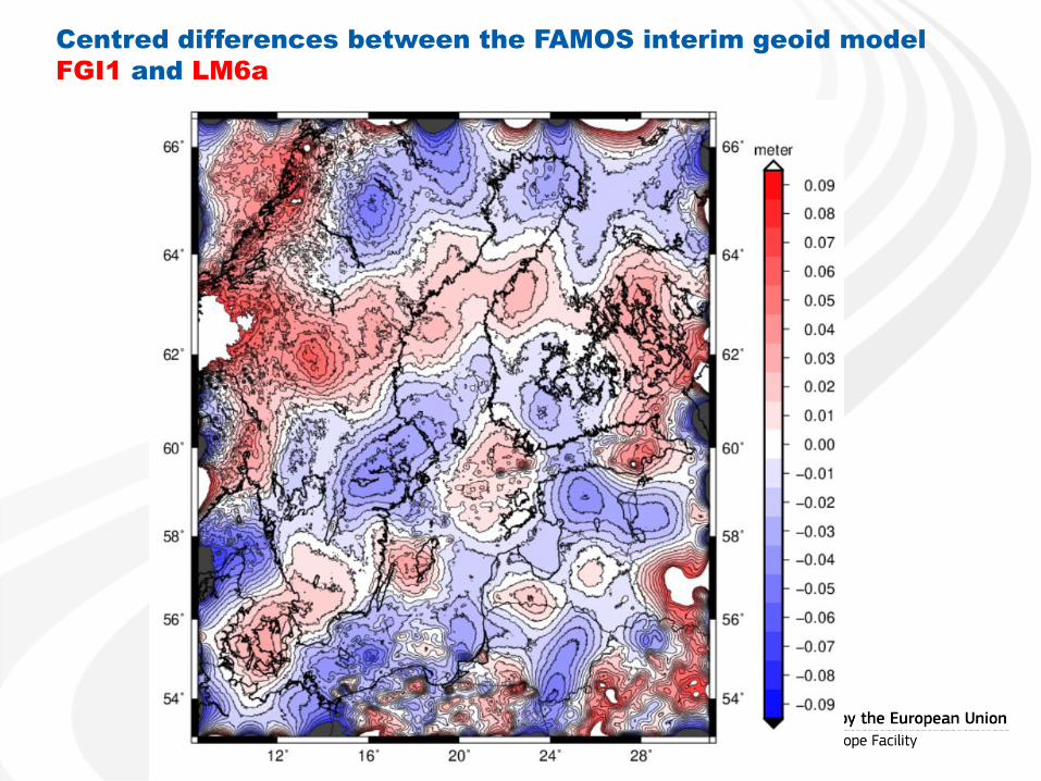
Centred differences between the FAMOS interim geoid model
FGI1 and LM6a