Embed Size (px)
Citation preview

Harbor Seal GIS: Harbor Seal GIS: Population Distribution in Southern MassachusettsPopulation Distribution in Southern Massachusetts
Nicole CabanaESRI SERUG
2009

OutlineOutline
• Background• Aerial Surveys• Objectives• Database• Models• Preliminary Results• Conclusion

BackgroundBackground
• The Harbor Seal Population in Southern New England is not well understood
• Seals have been protected since the 1970’s by the Marine Mammal Protection Act
• Seal populations are thought to be increasing• Species are not endangered, so receive little
research funding• Aerial surveys have been conducted since 2005• Data has not yet been analyzed
Aerial SurveysAerial Surveys• NOAA Twin Otter• Monthly: Oct - May• 750’• Canon EOS-1Ds
Mark II 16mp, 300mm• Observer + data
recorder• Low tide• Weather…

Study AreaStudy Area

ObjectivesObjectives
• Develop database• Develop models to analyze data
– Extract survey count totals– Depict distribution and changes– Assess environmental variables
• Provide GIS to NOAA scientists with User Manual
• Use information from other harbor seal research

Alaska Harbor SealsAlaska Harbor Seals
Boveng, P. (2004)

Alaska Harbor SealsAlaska Harbor Seals• Long term study• Well funded• Variables affect haulout behavior
Boveng, P.

Environmental VariablesEnvironmental Variables
• Wind speed• Temperature• Low Tide
Other VariablesOther Variables• Time of year• Site-specific weather conditions• Competition with gray seals

ConstraintsConstraints
• ArcView• Access Personal Geodatabase• Spatial Analyst• Simple data entry and analysis

DatabaseDatabase
• Access Personal Geodatabase• Very crude initial database• Complete redesign• Data cleaning!• Data entry forms• Data acquisition

DatabaseDatabase• Tables for aerial survey data:
– Flight Information– Site Specific Information– Seal Counts
• Tables for environmental data:– Tide– Weather
• Tables for relating data:– Haulout, Tide, Weather

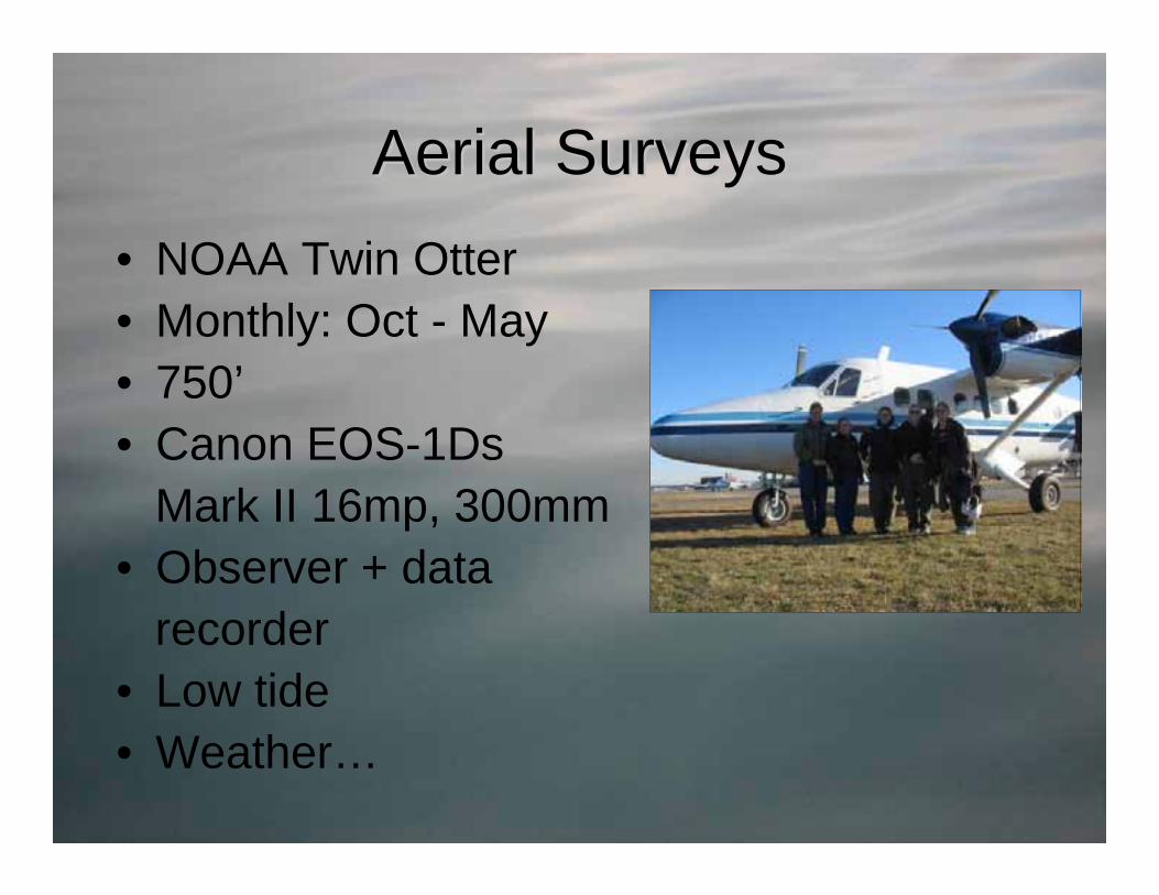
Database: FormsDatabase: Forms
Database: FormsDatabase: Forms

Database: FormsDatabase: Forms

Database: FormsDatabase: Forms

Database: RelationshipsDatabase: Relationships

Database: QueriesDatabase: Queries

Database: Data AcquisitionDatabase: Data Acquisition
• Photo counts• Tide data• Weather data

Data Acquisition: Tide DataData Acquisition: Tide Data

Acquisition: Tide DataAcquisition: Tide Data

Data Acquisition: Weather DataData Acquisition: Weather Data

Acquisition: Weather DataAcquisition: Weather Data

Data Acquisition: Seal CountsData Acquisition: Seal Counts

GIS: ModelsGIS: Models

Model: Seal Survey Totals BatchModel: Seal Survey Totals Batch

Batch: Summary StatisticsBatch: Summary Statistics

Batch: User ParametersBatch: User Parameters

Batch: Create FC & LayerBatch: Create FC & Layer

Batch: Iterate FieldBatch: Iterate Field

Batch: Create Batch: Create FCsFCs & Layers& Layers

Batch: OutputBatch: Output

Survey Totals Percent ChangeSurvey Totals Percent Change

Percent Change: User ParametersPercent Change: User Parameters

Percent Change: OutputPercent Change: Output
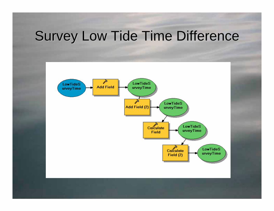
Survey Low Tide Time DifferenceSurvey Low Tide Time Difference

Other ModelsOther Models
• Tide Height Averages• Weather Select• Weather Survey Join

AnalysisAnalysis
• Limited seal count data available• Nantucket Harbor Jetties only complete set

AnalysisAnalysis
• Expectation 1: More seals haul out ±2 hours of low tide
• Expectation 2: More seals haul out between 1100-1400
• Expectation 3: More seals haul out when winds <35kts
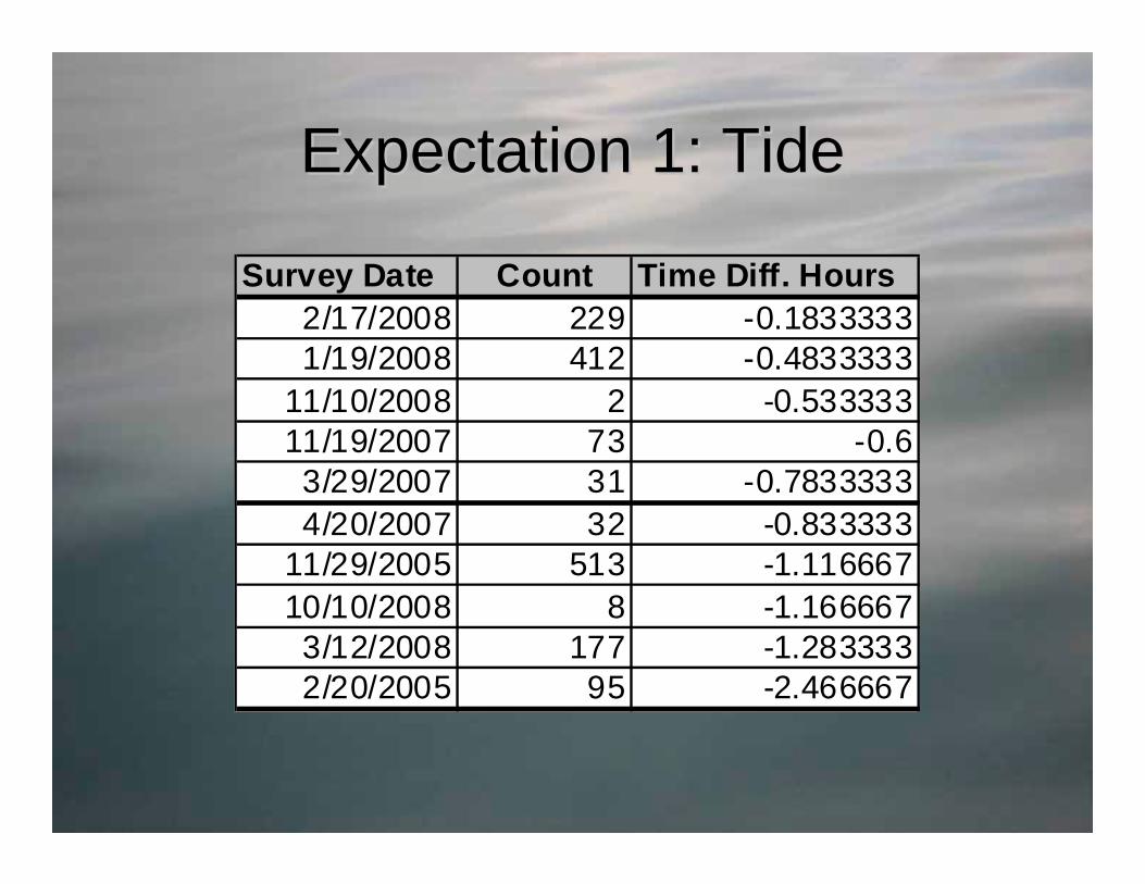
Expectation 1: TideExpectation 1: Tide
Survey Date Count Time Diff. Hours2/17/2008 229 -0.18333331/19/2008 412 -0.4833333
11/10/2008 2 -0.53333311/19/2007 73 -0.63/29/2007 31 -0.78333334/20/2007 32 -0.833333
11/29/2005 513 -1.11666710/10/2008 8 -1.1666673/12/2008 177 -1.2833332/20/2005 95 -2.466667

Expectation 2: TimeExpectation 2: TimeDate Count Time
2/20/2005 95 13:2910/10/2005 8 13:4811/19/2007 73 12:05
Date Count Time4/20/2007 32 8:103/12/2008 177 9:08
11/10/2008 2 14:371/19/2008 412 14:372/17/2008 229 14:42
11/29/2005 513 15:053/29/2007 31 15:28
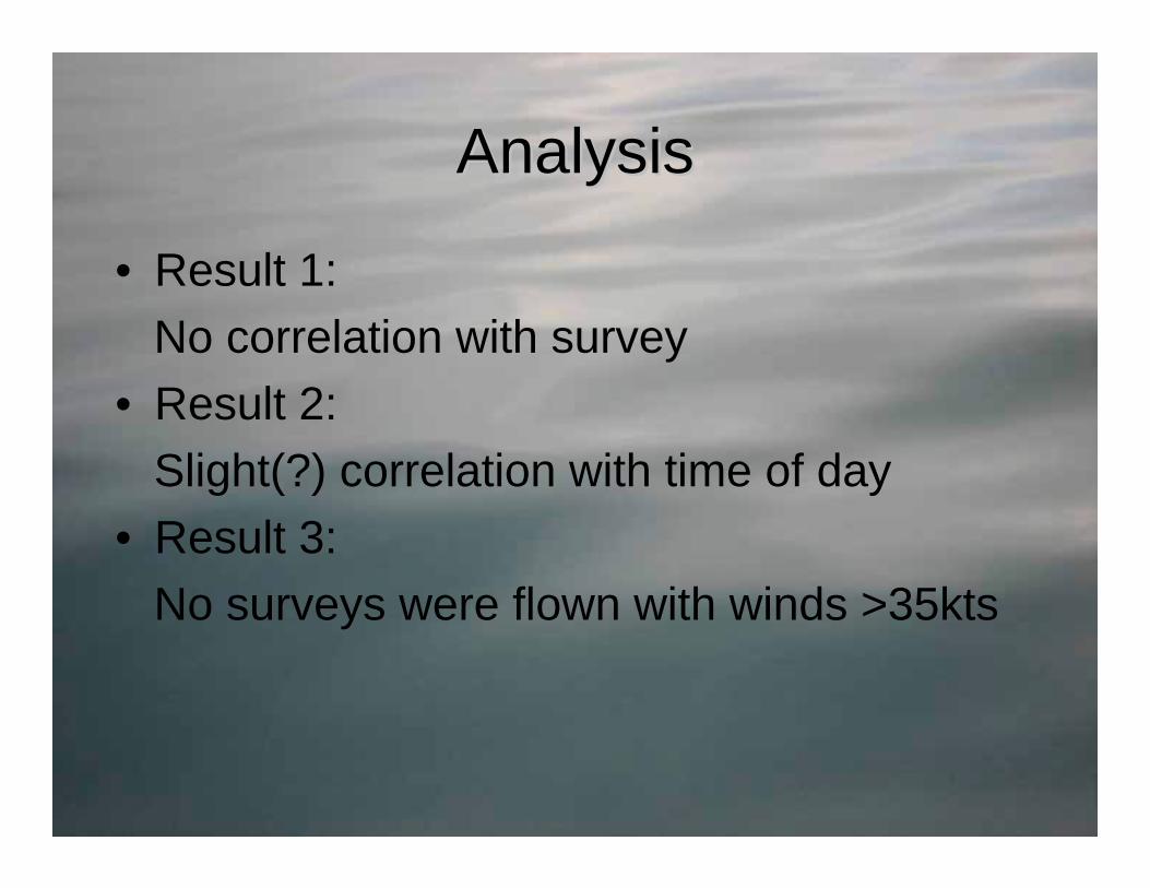
AnalysisAnalysis
• Result 1:No correlation with survey
• Result 2:Slight(?) correlation with time of day
• Result 3:No surveys were flown with winds >35kts

Weather AnalysisWeather Analysis
Strong correlation with weather
Date Count Wind Direction Wind Speed Temp Visibility11/29/2005 513 South (140-150) ~15kts 53 8nm mist, clear1/19/2008 412 West (260) ~10kts 36 10nm, clear2/17/2008 229 South (160) ~13kts 38 10nm, clear3/12/2008 177 South (160-190) ~14kts 41 6-9nm light rain mist, ovc 30001/17/2008 0 North (350) ~18-22kts, gusty 20 10nm, clear2/28/2006 0 Northwest (290-350) ~16-22kts, gusty 30 10nm, clear
10/24/2007 0 North (330-350) ~18-20kts, gusty 21 10nm, clear

Additional Analysis: Seasonal Additional Analysis: Seasonal DistributionDistribution
• Expectation:Highest numbers Dec-Jan-Feb-MarMedium numbers Nov-AprLow numbers Oct-May

Additional Analysis: Seasonal Additional Analysis: Seasonal DistributionDistribution
Date Count1/19/2008 4122/17/2008 2293/12/2008 177
12/30/2005 1581/27/2006 123
12/21/2007 1223/23/2005 1102/20/2005 1063/27/2006 952/13/2007 923/29/2007 313/4/2005 24
1/17/2007 02/28/2006 0
Date Count11/29/2005 51311/19/2007 734/25/2006 334/20/2007 32
11/10/2008 24/14/2008 0
Date Count10/10/2008 810/24/2007 05/14/2007 0

Percent Change: Seasonal DistributionPercent Change: Seasonal Distribution
November - December

Percent Change: Seasonal DistributionPercent Change: Seasonal Distribution
December - January

Percent Change: Seasonal DistributionPercent Change: Seasonal Distribution
March - April

Percent Change: Seasonal DistributionPercent Change: Seasonal Distribution
April - May

Future AnalysisFuture Analysis
• Count data • Distribution model• Share data via Internet

ConclusionConclusion
• Durable, versatile database and GIS• Manual will allow users with limited
knowledge to effectively use GIS• Powerful models and environmental
assessments will assist in future population modeling

DataData• Northeast Fisheries Science Center• NOAA: Coastline, Tide data• USGS Bathymetry data• ESRI State Boundary data• NGDC: Weather data • Iterate Value Script: Shitij Mehta• Alaska Harbor Seal Images: Peter Boveng
Thanks to Dr. Gordon Waring and Elizabeth Josephson for use of the seal count data.
Thanks also to AOC.

Questions?Questions?