Embed Size (px)
Citation preview
Handheld Augmented RealityDistributed System Seminar FS 2013
Reto LindeggerStudent, ETH [email protected]
INTRODUCTIONThe idea of computers helping people in their everyday lifehas been around for quite a while. One way a computer canbe used to assist a user to accomplish a task is by provid-ing important information relevant to this task. But to knowwhich information is relevant, which information is neededat the moment and how to display this information in the bestpossible way is a difficult task to solve. Luckily, a computercan take advantage of a wide range of input devices like dif-ferent sensors, cameras and user interfaces as well as sophis-ticated devices for displaying data like screens and projec-tors. The combination of processing input from the environ-ment, selecting relevant data and displaying the data in a forthe situation suited fashion is called augmented reality (AR).
Augmented RealityA clear and proper definition of the term augmented reality isvery difficult since augmented reality applications can havebig differences in characteristics, purpose and usage of theinput from the environment. When looking for a suitabledefinition, one is likely to find the work of Ronald T. Azumaabout this subject. In his paper ”A survey of AugmentedReality” [1], he defines Augmented Reality as systems thathave following characteristics:
• Combination of reality and virtual objects or information• Interactive in real time• Registered in 3D
He also explicitly states that rendered movies and 2D over-lays on live video streams are not counted as augmented real-ity since a rendered movie does not comply with the secondand a 2D overlay does not comply with the third requirement.
However, this definition is not the only one and as we willsee later, there are some applications which can be seen asaugmented reality application but violate one or more pointsfrom the definition above.
Another definition of augmented reality is the one on Wikipedia:”Augmented reality (AR) is a live, direct or indirect, view ofa physical, real-world environment whose elements are aug-mented by computer-generated sensory input such as sound,video, graphics or GPS data.” [2] This definition is less strictabout the appearance of information or virtual objects in 3D,but simply says that the reality is augmented by sensor input.How the augmentation is done is left open.
In this definitions, nothing is said about the computer and thedisplay used to generate and present the augmented reality. Itcan be a fixed installation in a room or it can be a integrated in
a helmet. An augmented reality system can also be designedto fit in a user’s hand. This type of AR systems is calledhandheld augmented reality.
Handheld Augmented RealityAs the name suggests, handheld augmented reality describesAR systems which can be hold by the user in his hand. So themain feature and also a great advantage is that such a systemis very portable. The user can take the system to the placewhere it is needed.
With the ongoing improvement of smartphones, the develop-ment and deployment of AR systems gets easier and cheaper.The use of smartphones for AR applications has many advan-tages. Beside the already mentioned low price, they are alsovery widespread which makes it easy to distribute an appli-cation among the users. Almost everyone has a smartphonenowadays and downloading an app is as simple as it gets.Another advantage is, that they are by default equipped witha lot of useful sensors like accelerometer, gyroscope, cam-era and GPS. Smartphones are commodity hardware, whichmeans nothing has to be produced only for the purpose of anAR application. All the required hardware already exists andcan be used to design and produce a tool for helping the userin any situation.
However, smartphones or handheld AR systems in generalhave some limitations. First of all, they have limited compu-tational power. Modern smartphones are well equipped andhave incredible CPU speed and a lot of Memory, comparedto desktop computers from some years ago. But still, thereare tasks which are much easier to solve with a high end PC.Then of course battery can be an issue, as with all portabledevices. Another drawback is that some tasks are very dif-ficult or almost impossible without a supporting infrastruc-ture. For precise localization, a infrastructure like Satellites(GPS) or some sensors or transmitters (indoor localization)are needed. So sometimes, the smartphone or portable ARdevice is just not enough. The last drawback I’d like to men-tion is linked to the user’s convenience. When using a hand-held augmented reality system, it has to be held in the handall the time. So one hand is always busy holding the devicewhile the other hand may be busy interacting with it.
Despite these limitations, handheld augmented reality de-vices may be of great help to the user in different situations.When carefully designed and tested, they can assist the userin his everyday life to accomplish tasks, which otherwisewould be much more difficult and/or time consuming. In therest of this document I shall present 4 different augmented
reality applications. I will discuss their purpose, the problemthey want to solve, their strengths and weaknesses and theirusability.
INDOOR NAVIGATIONThe first application I’d like to present addresses the problemof navigation inside a building. Since GPS and other satellitebased navigation systems are not available inside a building,conventional navigation solutions are not feasible. Another,more suited method for indoor navigation has to be found.
Problem StatementNow lets look at the problem that this application tries tosolve. Assume you are in a building you have never been be-fore. It is a large and complex building and finding an office,a meeting room or the nearest bathroom on your own is quitetricky. Wouldn’t it be nice, if your phone could give yourdirections? As mentioned above, navigation with GPS is notpossible indoors. To overcome this limitation, another wayof localizing the user has to be found. An operator of sucha system on the other side is of course interested in keepingthe effort needed to install a localization infrastructure andtherefore the required cost low. As addition, as in all naviga-tion systems, the presented solution should be as accurate aspossible to increase usability.
Previous WorkBefore I present a solution which meets the described re-quirements, let me show some attempts in providing an ac-curate and usable indoor navigation system.
Sensing InfrastructureOne way of localizing the user is by instrumentalizing theenvironment with a mesh of sensors. There have been sev-eral proposals for indoor navigation systems with a sens-ing infrastructure, of which I’d like to mention 3 interestingprojects:• Cyberguide by G.D. Abowd et al. [3]: Localization with
infrared
• The BAT system by M. Addlesee et al. [4]: Localizationwith subsonic waves
• Evacuation system by L. Chittaro and D. Nadalutti [5]: Lo-calization with RFID
The problem with these solutions is obviously that they areheavily infrastructure dependent. This is maybe applicable ina small area or when high accuracy is very important. How-ever, to equip a large building with this dense infrastructureis not realistic and would also be very costly.
Sparse InfrastructureSince a dense grid of sensors is complex and expensive, amore cost efficient solution is to have sparse infrastructure.The idea is to deploy checkpoints in selected spots all aroundthe building. At these checkpoints the user is located, he isinformed where he is and how he can continue to get to hisdestination. On the way between checkpoints however, theuser is not assisted and has to find his way without help.
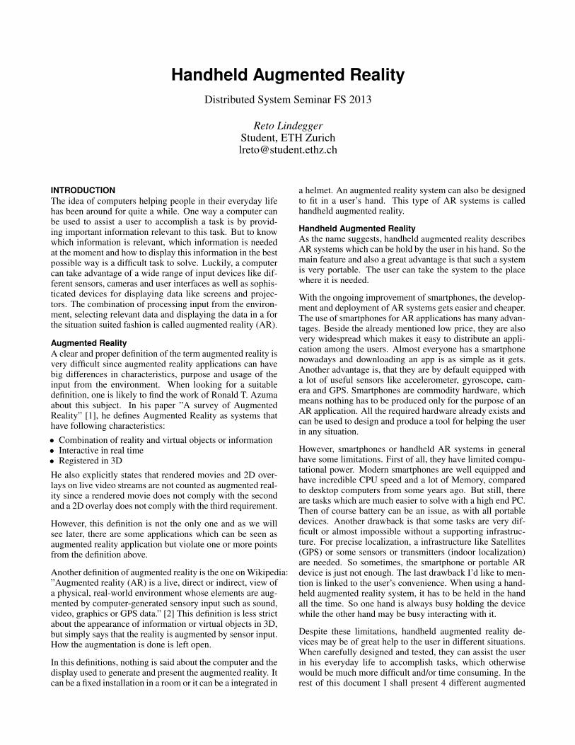
Figure 1: Indoor Navigation. User standing at infopoint, map with current location and path to destina-tion.
Movement MeasuringThis method of navigation does not rely on any infrastruc-ture at all. The system measures the movement of the userwith the help of different sensors like accelerometer and gy-roscope. When the start point is known, the system can soguide the user through the building to the desired destinationand provide a turn-by-turn navigation. The problems hereis that the localization of the user becomes quite inaccurateover time when there are no checkpoints in between wherethe system could recalibrate the user’s location. Also, it ishard to distinguish whether the user actually moved or if theuser just moved the handheld device around.
SolutionWhen you have some halfway good solutions with differentadvantages and drawbacks, the best thing to do is combiningthem to get an accurate, reliable solution with high usabil-ity. This is what Alessandro Mulloni and others in their pa-per ”Handheld Augmented Reality Indoor Navigation withActivity-Based Instructions” did [6]. They combined exo-centric and egocentric navigation to get an accurate indoornavigation system. To keep the costs low, they didn’t usea dense infrastructure but rather just checkpoints all aroundthe building. The checkpoints (also called info points) are inthis case floor-mounted posters which can be detected by theback-facing camera of the smartphone (a seen in figure 1).Of course other technology like RFID could be used. When auser arrives at a checkpoint, the system knows exactly wherehe is, can recalibrate the navigation system and update theuser’s location. On the other side, the user also knows wherehe is, since the system can show him a map with detailedinformation about his location and the path that lies ahead.When the user is moving between the info points, the move-ment of the phone are measured to get an approximation ofthe user’s location. This information is used to help the userfind the next checkpoint by giving him directions in terms ofso called activities. The activities are instructions like ”walk4 steps”, ”turn right”, ”walk 6 steps”. The user interface isadapted to the current system state: at info points, a map withthe exact location is shown. Between info points, no map isvisible since the exact location is not known, but directionsand navigation activities are shown. The two different user
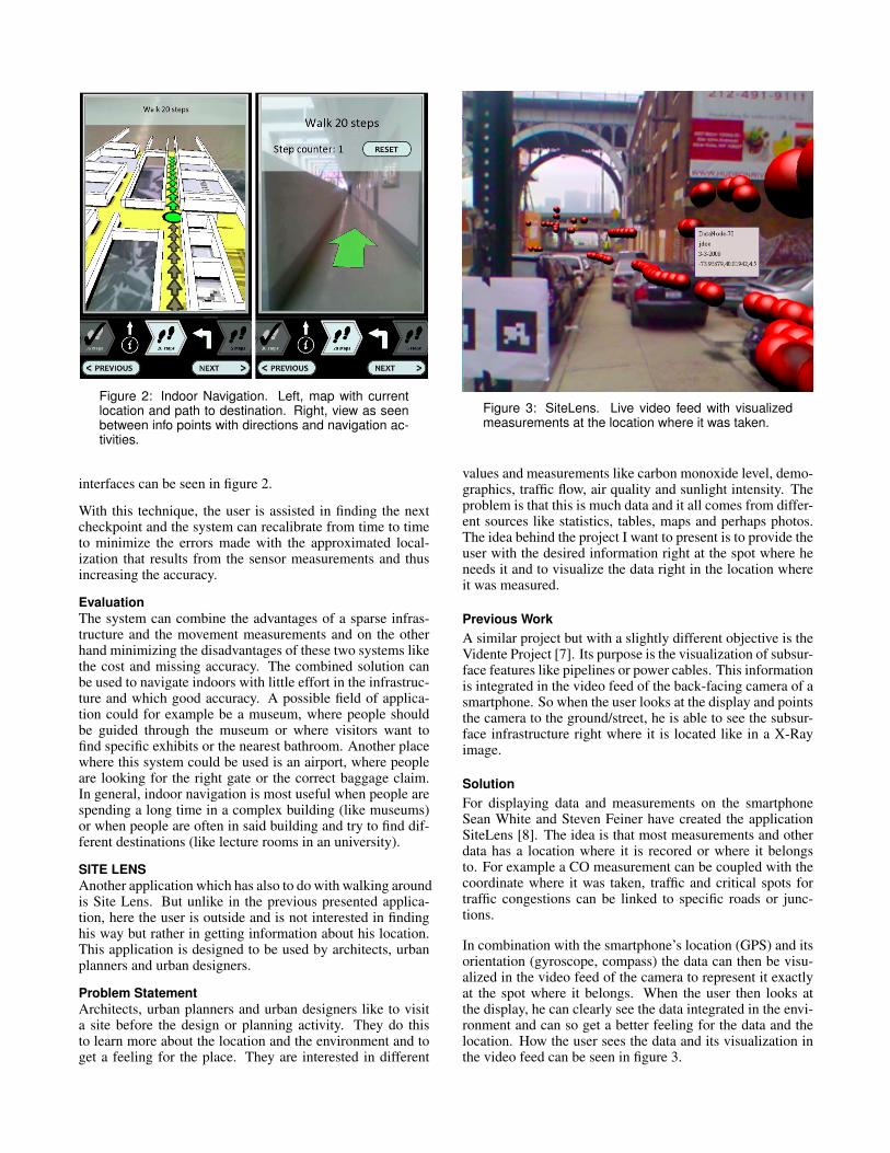
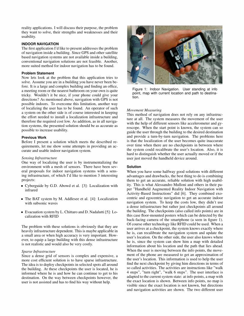
Figure 2: Indoor Navigation. Left, map with currentlocation and path to destination. Right, view as seenbetween info points with directions and navigation ac-tivities.
interfaces can be seen in figure 2.
With this technique, the user is assisted in finding the nextcheckpoint and the system can recalibrate from time to timeto minimize the errors made with the approximated local-ization that results from the sensor measurements and thusincreasing the accuracy.
EvaluationThe system can combine the advantages of a sparse infras-tructure and the movement measurements and on the otherhand minimizing the disadvantages of these two systems likethe cost and missing accuracy. The combined solution canbe used to navigate indoors with little effort in the infrastruc-ture and which good accuracy. A possible field of applica-tion could for example be a museum, where people shouldbe guided through the museum or where visitors want tofind specific exhibits or the nearest bathroom. Another placewhere this system could be used is an airport, where peopleare looking for the right gate or the correct baggage claim.In general, indoor navigation is most useful when people arespending a long time in a complex building (like museums)or when people are often in said building and try to find dif-ferent destinations (like lecture rooms in an university).
SITE LENSAnother application which has also to do with walking aroundis Site Lens. But unlike in the previous presented applica-tion, here the user is outside and is not interested in findinghis way but rather in getting information about his location.This application is designed to be used by architects, urbanplanners and urban designers.
Problem StatementArchitects, urban planners and urban designers like to visita site before the design or planning activity. They do thisto learn more about the location and the environment and toget a feeling for the place. They are interested in different
Figure 3: SiteLens. Live video feed with visualizedmeasurements at the location where it was taken.
values and measurements like carbon monoxide level, demo-graphics, traffic flow, air quality and sunlight intensity. Theproblem is that this is much data and it all comes from differ-ent sources like statistics, tables, maps and perhaps photos.The idea behind the project I want to present is to provide theuser with the desired information right at the spot where heneeds it and to visualize the data right in the location whereit was measured.
Previous WorkA similar project but with a slightly different objective is theVidente Project [7]. Its purpose is the visualization of subsur-face features like pipelines or power cables. This informationis integrated in the video feed of the back-facing camera of asmartphone. So when the user looks at the display and pointsthe camera to the ground/street, he is able to see the subsur-face infrastructure right where it is located like in a X-Rayimage.
SolutionFor displaying data and measurements on the smartphoneSean White and Steven Feiner have created the applicationSiteLens [8]. The idea is that most measurements and otherdata has a location where it is recored or where it belongsto. For example a CO measurement can be coupled with thecoordinate where it was taken, traffic and critical spots fortraffic congestions can be linked to specific roads or junc-tions.
In combination with the smartphone’s location (GPS) and itsorientation (gyroscope, compass) the data can then be visu-alized in the video feed of the camera to represent it exactlyat the spot where it belongs. When the user then looks atthe display, he can clearly see the data integrated in the envi-ronment and can so get a better feeling for the data and thelocation. How the user sees the data and its visualization inthe video feed can be seen in figure 3.
EvaluationThe system is great to make the process of visiting a site andcomparing the data with the location easier. The user can sosee the data in relation to its relevant location. What is notyet integrated but would be a good improvement is the ac-quiring of data. So far, the system only can display measureddata. The possibility to collect and share data while walk-ing around would be a good idea and increase the amount ofavailable data and thus be a great advantage to all users.
LOOKING AT IMAGESThe next application I’m going to present tries to solve an-other task. Here it is not data that is visualized in a videofeed. Actually, unlike in the other two examples, the videofeed of the back-facing camera is not used at all and neitheris the location. However, this time it’s the front-facing cam-era that is used. But more about this later, first I’m going toshow the problem that is to be solved.
Problem StatementAs digital camera improve, the produced pictures are gettingbigger and bigger. But it’s not only the resolution that im-proves over time. Today’s pictures are not always flat 2Dphotos anymore. There are panoramic 360 images, multi-perspective and multi-view images and much more. Of coursethere are also the normal 2D stills, of course in high resolu-tion to get the best possible result.
On the other side, the displays where these pictures are be-ing viewed are not getting much bigger. If anything, they aregetting smaller since pictures are often viewed on mobile de-vices like phones or tables nowadays. The question is nowhow to make the viewing of large imagery as convenient aspossible on these mobile devices.
Previous WorkOf course, there has been a lot of people thinking about thisproblem and there are also some quite interesting techniquesand solutions to solve it. A well-known solution is Google’sStreetView. When using StreetView on a mobile phone, onecan spin around 360 and move the phone up and down tonavigate in the panorama and to see all possible spots inthe picture. This hand free interaction with the phone isaccomplished by using the input from the available sensors(accelerometer and gyroscope). Another similar product isTourWrist [9], where users can create 360 panoramas, sharethem with other users and explore the pictures my spinningaround and moving the phone.
The Glasses-free 3D display [10] is also an application forsmartphones for viewing images but with another goal, namelyto see 3D pictures. Imagine an object which was photographedfrom different angles. Of course on the phone you can onlywatch one picture (one perspective) at a time. But by trackingthe face of the user, smartphone application can decide whichpicture from what perspective should be shown to create theimpression of a 3D object where the user can see differentsides of the object by moving his head around.
SolutionInstead of sticking to one type of input, Neel Joshi, and oth-ers [11] combined different input sources to get a convenient
and usable way of interacting with the device for viewinglarge imagery without having to use the hands. Controllingthe phone with the hands while viewing images has somedrawbacks. First of all, the hand that is used to control theapplication obscures a big part of the display and thus hidesthe picture that is displayed. Another disadvantage is that theapplication can’t always distinguish between a dragging oran interaction with the picture like drawing.
Also, they wanted to create an input interface that doesn’t re-quire spinning in place for 360 for watching a 360 image. Forthis reason, they combined the input from the gyroscope withface tracking using the front-facing camera. So like in thereal world, were we analyze an object by rotating the objector by moving our gaze relative to the object, the navigation isdone by either rotating the device or by moving our head andtherefore looking in a different angle at the screen. The ap-plication moves the picture according to device’s orientationand the angle in which the viewer looks at the screen. Withthis technique, a smooth navigation in the picture is possibleas well as the already described viewing of 3D objects bymoving the head relatively to the screen.
EvaluationUsing face tracking as input for viewing images is a greatidea and very interesting for creating the impression of a 3Dscreen with 2D images. Hand free smartphone interaction isa good way to improve usability and convenience when usingsmartphones and aims to make the interaction easier and feelmore natural.
The main problem with this new application is that mostusers already are familiar to the traditional interaction tech-niques like zooming and panning by finger movements. Whenintroducing a new technique, it first feels unnatural and takessome time to get used to it.
KINECT FUSIONSo far we have seen an indoor navigation system, a sophis-ticated solution for displaying measurements in the environ-ment where it was taken and an application for viewing largeimages without having to touch the screen. In all these sys-tems, the goal is mainly to display data or information forthe user. Now I’m going to present an other application ofaugmented reality which does not only display data, but isalso capable of acquiring enough data do represent the envi-ronment as a 3D model. In this AR application, the handhelddevice is not a display but actually a camera that is used toreconstruct the environment. So let’s first look at the task thatthis system is trying to solve.
Problem StatementAs stated above, the goal is to get an accurate digital re-construction of the environment. For this purpose, the usershould be able to walk around with a camera in his handwhich captures the necessary information that is used to builda replica of the real world. The idea is to do this in real time,so that the model is build at the time the camera is movedaround. The real time constraint is also necessary to noticechanges in the scene and to react according to these changes.We will see later how the system can react to sudden changesin the scenery. The 3D reconstruction should also be accu-
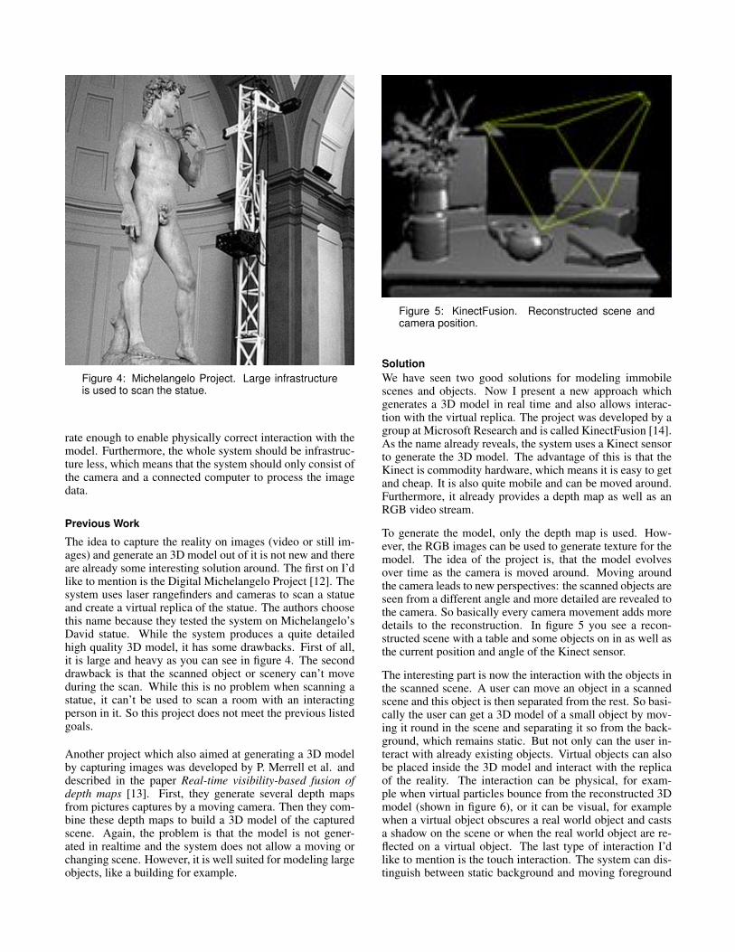
Figure 4: Michelangelo Project. Large infrastructureis used to scan the statue.
rate enough to enable physically correct interaction with themodel. Furthermore, the whole system should be infrastruc-ture less, which means that the system should only consist ofthe camera and a connected computer to process the imagedata.
Previous Work
The idea to capture the reality on images (video or still im-ages) and generate an 3D model out of it is not new and thereare already some interesting solution around. The first on I’dlike to mention is the Digital Michelangelo Project [12]. Thesystem uses laser rangefinders and cameras to scan a statueand create a virtual replica of the statue. The authors choosethis name because they tested the system on Michelangelo’sDavid statue. While the system produces a quite detailedhigh quality 3D model, it has some drawbacks. First of all,it is large and heavy as you can see in figure 4. The seconddrawback is that the scanned object or scenery can’t moveduring the scan. While this is no problem when scanning astatue, it can’t be used to scan a room with an interactingperson in it. So this project does not meet the previous listedgoals.
Another project which also aimed at generating a 3D modelby capturing images was developed by P. Merrell et al. anddescribed in the paper Real-time visibility-based fusion ofdepth maps [13]. First, they generate several depth mapsfrom pictures captures by a moving camera. Then they com-bine these depth maps to build a 3D model of the capturedscene. Again, the problem is that the model is not gener-ated in realtime and the system does not allow a moving orchanging scene. However, it is well suited for modeling largeobjects, like a building for example.
Figure 5: KinectFusion. Reconstructed scene andcamera position.
SolutionWe have seen two good solutions for modeling immobilescenes and objects. Now I present a new approach whichgenerates a 3D model in real time and also allows interac-tion with the virtual replica. The project was developed by agroup at Microsoft Research and is called KinectFusion [14].As the name already reveals, the system uses a Kinect sensorto generate the 3D model. The advantage of this is that theKinect is commodity hardware, which means it is easy to getand cheap. It is also quite mobile and can be moved around.Furthermore, it already provides a depth map as well as anRGB video stream.
To generate the model, only the depth map is used. How-ever, the RGB images can be used to generate texture for themodel. The idea of the project is, that the model evolvesover time as the camera is moved around. Moving aroundthe camera leads to new perspectives: the scanned objects areseen from a different angle and more detailed are revealed tothe camera. So basically every camera movement adds moredetails to the reconstruction. In figure 5 you see a recon-structed scene with a table and some objects on in as well asthe current position and angle of the Kinect sensor.
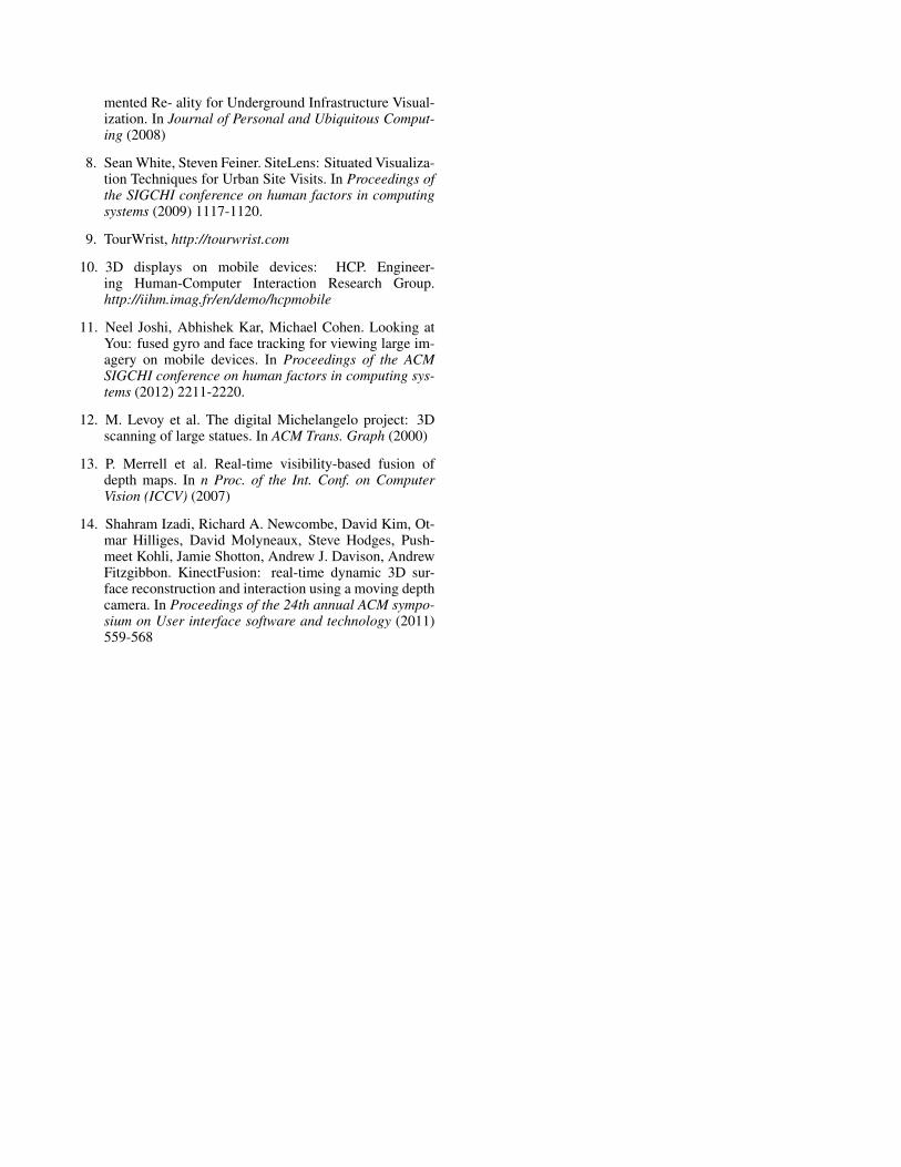
The interesting part is now the interaction with the objects inthe scanned scene. A user can move an object in a scannedscene and this object is then separated from the rest. So basi-cally the user can get a 3D model of a small object by mov-ing it round in the scene and separating it so from the back-ground, which remains static. But not only can the user in-teract with already existing objects. Virtual objects can alsobe placed inside the 3D model and interact with the replicaof the reality. The interaction can be physical, for exam-ple when virtual particles bounce from the reconstructed 3Dmodel (shown in figure 6), or it can be visual, for examplewhen a virtual object obscures a real world object and castsa shadow on the scene or when the real world object are re-flected on a virtual object. The last type of interaction I’dlike to mention is the touch interaction. The system can dis-tinguish between static background and moving foreground
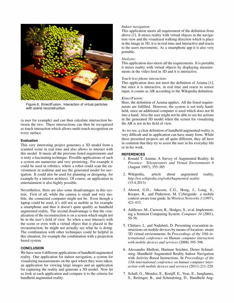
Figure 6: KinectFusion. Interaction of virtual particleswith scene reconstruction.
(a user for example) and can then calculate intersection be-tween the two. These intersections can then be recognizedas touch interaction which allows multi touch recognition onevery surface.
EvaluationThis very interesting project generates a 3D model from ascanned scene in real time and also allows to interact withthis model. It meets all the previous listed requirements andis truly a fascinating technique. Possible applications of sucha system are numerous and very promising. For example itcould be used in robotics, where a robot could scan the en-vironment in realtime and use the generated model for nav-igation. It could also be used for planning or designing, forexample by a interior architect. Of course, an application inentertainment is also highly possible.
Nevertheless, there are also some disadvantages in this sys-tem. First of all, while the camera is small and very mo-bile, the connected computer might not be. Even though alaptop could be used, it’s still not as mobile as for examplea smartphone and thus it doesn’t quite qualify as handheldaugmented reality. The second disadvantage is that the visu-alization of the reconstruction is on a screen which might notbe in the user’s field of view. So when a user interacts withthe scene or even with a virtual object that is placed in thereconstruction, he might not actually see what he is doing.The combination with other techniques could be helpful inthis situation, for example the combination with a projectionbased system.
CONCLUSIONWe have seen 4 different applications of handheld augmentedreality. One application for indoor navigation, a system forvisualizing measurements on the spot where they were taken,an application for viewing large images and an applicationfor capturing the reality and generate a 3D model. Now letus look at each application and compare it to the criteria forhandheld augmented reality.
Indoor navigation:This application meets all requirement of the definition fromabove [1]. It mixes reality with virtual objects in the naviga-tion view and the visualized walking direction which is placein the image in 3D, it is in real time and interactive and reactsto the users movements. As a smartphone app it is also veryportable.
SiteLens:This application also meets all the requirements. It is portable,it mixes reality with virtual objects by displaying measure-ments in the video feed in 3D and it is interactive.
Touch-less phone interaction:This application does not meet the definition of Azuma [1],but since it is interactive, in real time and reacts to sensorinput, it counts as AR according to the Wikipedia definition.
KinectFusion:Here, the definition of Azuma applies. All the listed require-ments are fulfilled. However, the system is not truly hand-held, since an additional computer is used which does not fitinto a hand. Also the user might not be able to see his actionsin the generated 3D model when the screen for visualizingthe AR is not in his field of view.
As we see, a clear definition of handheld augmented reality isvery difficult and its application can have many form. Whilethese presented projects are all quite different, they all havein common that they try to assist the user in his everyday lifeor in his work.
REFERENCES1. Ronald T. Azuma. A Survey of Augmented Reality. In
Presence: Teleoperators and Virtual Environments 6(August 1997), 355-385
2. Wikipedia, article about augmented reality,http://en.wikipedia.org/wiki/Augmented reality(15.4.2013)
3. Abowd, G.D., Atkeson, C.G., Hong, J., Long, S.,Kooper, R., and Pinkerton, M. Cyberguide: a mobilecontext-aware tour guide. In Wireless Networks 3 (1997),421-433.
4. Addlesee, M., Curwen, R., Hodges, S., et al. Implement-ing a Sentient Computing System. Computer 34 (2001),50-56.
5. Chittaro, L. and Nadalutti, D. Presenting evacuation in-structions on mobile devices by means of location- aware3D virtual environments. In Proceedings of the 10th in-ternational conference on Human computer interactionwith mobile devices and services (2008) 395-398.
6. Alessandro Mulloni, Hartmut Seichter, Dieter Schmal-stieg. Handheld Augmented Reality Indoor Navigationwith Activity-Based Instructions. In Proceedings of the13th international conference on human computer inter-action with mobile devices and services (2011) 211-220.
7. Schall, G., Mendez, E., Kruijff, E., Veas, E., Junghanns,S., Reitinger, B., and Schmalstieg, D., Handheld Aug-
mented Re- ality for Underground Infrastructure Visual-ization. In Journal of Personal and Ubiquitous Comput-ing (2008)
8. Sean White, Steven Feiner. SiteLens: Situated Visualiza-tion Techniques for Urban Site Visits. In Proceedings ofthe SIGCHI conference on human factors in computingsystems (2009) 1117-1120.
9. TourWrist, http://tourwrist.com
10. 3D displays on mobile devices: HCP. Engineer-ing Human-Computer Interaction Research Group.http://iihm.imag.fr/en/demo/hcpmobile
11. Neel Joshi, Abhishek Kar, Michael Cohen. Looking atYou: fused gyro and face tracking for viewing large im-agery on mobile devices. In Proceedings of the ACMSIGCHI conference on human factors in computing sys-tems (2012) 2211-2220.
12. M. Levoy et al. The digital Michelangelo project: 3Dscanning of large statues. In ACM Trans. Graph (2000)
13. P. Merrell et al. Real-time visibility-based fusion ofdepth maps. In n Proc. of the Int. Conf. on ComputerVision (ICCV) (2007)
14. Shahram Izadi, Richard A. Newcombe, David Kim, Ot-mar Hilliges, David Molyneaux, Steve Hodges, Push-meet Kohli, Jamie Shotton, Andrew J. Davison, AndrewFitzgibbon. KinectFusion: real-time dynamic 3D sur-face reconstruction and interaction using a moving depthcamera. In Proceedings of the 24th annual ACM sympo-sium on User interface software and technology (2011)559-568