Embed Size (px)
Citation preview
CITY OF LAREDO, TEXAS
SUBDIVISION ORDINANCE HANDBOOK
APPENDIX B OF THE CODE OF ORDINANCES

1
HANDBOOK OF THE
SUBDIVISION ORDINANCE
OF THE
CITY OF LAREDO, TEXAS
APPENDIX B OF THE
CODE OF ORDINANCES
CITY OF LAREDO
With Amendments In effect as of 11/4/2013

2
SUBDIVISION ORDINANCE # 84-0-0006
OF THE
CITY OF LAREDO, TEXAS
AN ORDINANCE REPEALING AND ABOLISHING THE LAND DEVELOPMENT ORDINANCE DATED SEPTEMBER 2, 1980 WITH ALL AMENDMENTS THERETO AND ESTABLISHING A SUBDIVISION ORDINANCE PRESCRIBING RULES AND REGULATIONS GOVERNING PLATS AND SUBDIVISIONS OF LAND WITHIN THE CORPORATE LIMITS AND EXTRA - TERRITORIAL JURISDICTION OF THE CITY OF LAREDO; PROVIDING FOR FEES TO BE CHARGED; PROHIBITING THE EXPENDITURE OF PUBLIC FUNDS IN SUBDIVISIONS NOT APPROVED BY THE CITY COUNCIL OF THE CITY OF LAREDO; REPEALING ALL ORDINANCES IN CONFLICT HEREWITH; PROVIDING A SAVINGS CLAUSE; PROVIDING FOR APPEALS; ESTABLISHING A PENALTY FOR VIOLATIONS OF THE ORDINANCE; AND PROVIDING FOR PUBLICATION AND EFFECTIVE DATE.
WHEREAS, under the laws of the State of Texas every owner of a tract of land situated within
the Corporate limits and/or within the Extra-Territorial Jurisdiction of the corporate limits of the
City of Laredo who may subdivide, plat or replat such tract of land is required to submit plats
to the City of Laredo for approval; and, WHEREAS, the City Council of the City of Laredo is
empowered to adopt and promulgate rules and regulations governing plats and subdivisions
of land within said area.
NOW, THEREFORE, BE IT ORDAINED BY THE CITY COUNCIL OF THE CITY OF LAREDO: 1. That the Land Development Ordinance dated September 2, 1980 of the City of Laredo with all amendments thereto is hereby repealed and abolished; and 2. That this Subdivision ordinance of the City of Laredo shall take effect and be in force from and after publication; and 3. That from and after the passage and publication of this Subdivision Ordinance, all plats and subdivisions of land within the corporate limits of the City of Laredo, and all plats and subdivisions of land outside the corporate limits of the City of Laredo that the City Council may include within the corporate limits of the City by an extension of said corporate limits, and all tracts within the Extra Territorial Jurisdiction of the corporate limits, shall conform to the rules and regulations listed herein, to wit:
3
TABLE OF CONTENTS
I. CHAPTER I - DEFINITIONS ........................................................................................... 5 II. CHAPTER II - SUBDIVISION PLATS REQUIRED, FORM AND CONTENT OF PLANS,
APPROVAL PROCESS FOR ALL PETITIONS, INCLUDING SPECIAL USES, AND PERFORMANCE BOND REQUIREMENTS
Section 2-1: Unlawful to subdivide land except by an approved plat (00-O-144, 6/5/00;
2009-O-213, 12/7/09) ....................................................................................... 7 Section 2-2: Pre-application Review .......................................................................... 7 Section 2-3: Submission of Subdivision Plat (04-O-185, 8/16/04; 04-O-205, 9/27/04; 07-O-201,
10/15/07;
2010-O-032, 4/5/10; 2011-O-171, 12/19/11; 2012-O-156, 9/17/12; 2012-O-195, 12/3/12) ................ 8 Section 2-4: Performance Bonds (04-O-205, 9/27/04) ........................................................ 18 Section 2-5: Special Assessments ............................................................................ 19 Section 2-6: Street Names and House Numbering; Proof of Payment of Taxes before Commission Approval ..................................................... 19 Section 2-7: Procedures Following Commission Approval........................................ 20 III. CHAPTER III - SUBDIVISION DESIGN STANDARDS
Section 3-1: Construction Plans ................................................................................ 22 Section 3-2: Streets and Alleys (08-O-054, 3/24/08) ........................................................... 22 Section 3-3: Lots and Lot Arrangement ..................................................................... 31 Section 3-4: Easements (99-O-186, 6/28/99; 2012-O-108, 8/20/12) .............................................. 32 Section 3-5: Laboratory Testing ................................................................................ 34 Section 3-6: Street Lighting ....................................................................................... 35 Section 3-7: Lot Grading ........................................................................................... 35 Section 3-8: Commercial Condominium Design Standards ...................................... 36 Section 3-9: Electrical Service ................................................................................... 36
IV. CHAPTER IV - EXCEPTIONS, ENFORCEMENT, VALIDITY
Section 4-1: Exceptions ............................................................................................. 37 Section 4-2: Enforcement (2005-O-070, 4/4/05; 2009-O-213, 12/7/09; 2013-O-142, 11/4/13) ................... 38
V. CHAPTER V - MISCELLANEOUS
Section 5-1: Interpretation, Purpose and Conflict ...................................................... 40

4
Section 5-2: Enforcement; Procedure ....................................................................... 40 Section 5-3: Extraterritorial Effect of this Ordinance ................................................. 40 Section 5-4: Penalty .................................................................................................. 40 Section 5-5: Right of Appeal ...................................................................................... 41 Section 5-6: Repealing Clause .................................................................................. 41 Section 5-7: Filing Fee............................................................................................... 41 Section 5-8: Severability ............................................................................................ 41 Section 5-9: Headings of Sections ............................................................................ 41 Section 5-10: Uniform Application and Enforcement .................................................. 41
VI. CHAPTER VI - AMENDMENTS AND CHANGES
Section 6-1: Requirements ........................................................................................ 42 Section 6-2: Notice Required .................................................................................... 42
5
CHAPTER I
DEFINITIONS For the purpose of interpretations and application of this ordinance certain words herein are defined as follows: (1) Grades:
a. For buildings having walls adjoining one street only, the elevation of the street curb at the center wall adjoining the street.
b. For buildings having walls adjoining more than one street, the average of the
elevation of the street curb at the centers of all walls adjoining the streets. c. For buildings having no wall adjoining the street, the average level of the finished
surface of the ground adjacent to the exterior walls of the building, if approved by the City Engineer.
Any wall approximately parallel to and not more than five (5) feet from a street line is
to be considered as adjoining the street. Where a curb exists, the grade shall be established by the City Engineer.
(2) Plat
An instrument upon which is depicted a map, drawing, or plan of a certain tract of land, drawn to scale, which is designed to facilitate the location of, reference to, and legal description of such tract, or lots contained therein, or both, by indication in the map, drawing or plan of certain points of reference which are known to or which are described to coincide with established survey monuments.
(3) Subdivision or Subdivide:
1. The division of an existing lot or lots or a portion or portions thereof into new lots; or the combination of existing lots or portions thereof to create a new lot or new lots; or both such division and combination. In addition, the term "subdivision" includes the application for a plat of a "lot of record" as defined in Section 24-61 (b)(59) (ii) of the Zoning Ordinance. (As amended 11/21/88, Ordinance # 88-0-148)
2. The establishment by recording in the office of the County Clerk of a conveyance or
other instrument dedicating a street, highway, road or alley or other public right-of-way through a tract of land.
3. Excluded from the definition of "subdivision" are the recording of:
a) a conveyance of a parcel of land to or between adjoining property owners which
does not create an additional building lot, b) a conveyance of land which is in excess of ten acres of land, which does not
create a new street, and is used for agricultural purposes, c) a conveyance in one instrument to the same grantee or grantees of all of a lot of
record. (4) Subdivision Plat
6
Wherever pursuant to this ordinance or pursuant to any other ordinance of the City of Laredo, an owner of land is required to have a plat of said land submitted to and approved by the Planning and Zoning Commission, whether such proposed plat be of one or more lots, such plat shall be deemed a subdivision plat within the meaning of this ordinance, and in order to be approved the proposed plat must meet the procedural and substantive requirements of this ordinance. (As amended 11/21/88, Ordinance # 88-0-148)
(5) Incorporation of Definitions from Zoning Ordinance
All definitions set out in Section 24-61 of the Zoning Ordinance of August 2, 1983, as amended, are hereby incorporated in this Subdivision Ordinance and are made a part of this Subdivision Ordinance for all purposes. (As amended 10/15/85, Ordinance # 85-0-183)
(6) Industrial Park
A subdivision of at least ten (10) acres, divided into lots of not less than one (1) acre in size and developed for, or in use for, uses that are only allowed in the M-1 Light Manufacturing and M-2 Heavy Industrial Districts, as defined in the Zoning Ordinance of August 2, 1983, As amended from time to time (Ordinance No. 83-0-0067) (As amended 10/15/85, Ordinance
# 85-0-l83)

7
CHAPTER II
SUBDIVISION PLATS REQUIRED, FORM AND CONTENT OF PLATS, APPROVAL PROCESS FOR ALL PETITIONS, INCLUDING SPECIAL USES, AND PERFORMANCE BOND REQUIREMENTS
Section 2-1: Unlawful to subdivide land except by an approved plat (a) It shall be unlawful for any person being the owner, or agent of a person, having any land
within the City of Laredo or within the extraterritorial jurisdiction of the corporate limits of the City of Laredo to subdivide or lay out such land in lots unless by a plat which shall have been approved and recorded pursuant to the regulations contained herein, except as stated in (b), (c), (d), and (e) infra.
(b) An amending plat may be approved and issued, (the issuance and approval of which shall
not require notice, hearing, or approval of other lot owners) if the sole purpose of such approval and issuance is authorized under Section 212.016 of the Local Government Code.
(c) Any lot of record as defined in Appendix A of the Laredo Land Development code. (As
amended 12/7/09, Ordinance # 2009-O-213)
(d) No subdivision plat is required to be filed with the Commission under the provisions of this
chapter if the land to be subdivided is to be divided into two (2) or more tracts, where the smallest remaining parcel is more than forty-five (45) acres in size and to be used for agricultural purposes.
(e) No subdivision plat is required in the event that abutting street rights-of-way, whether
improved or unimproved, are sold or conveyed to adjacent property-owners by the City of Laredo.
Section 2-2: Pre-application review Prior to the filing of the application for plat approval, or of the application for a special use permit, or other requirements of this ordinance, the owner or his designated agent may request a conference with the Staff Coordinating Committee as designated below, concerning the plans and data as specified herein. The Staff Coordinating Committee shall be composed of the following members or their representatives:
1. The Director of Public Utilities 2. The City Engineer 3. The City Building Official 4. The City Fire Chief 5. The City Planning Director 6. The City Public Works Director
The purpose of the Staff Coordinating Committee shall be to assist an applicant prior to the submittal of an application to the Commission, and to coordinate the technical aspects of development, and to advise the City Manager concerning planning issues. The Committee may request the assistance such other staff members and agency representatives as the City deems appropriate, including but not limited to the City Traffic Coordinator, the City Parks and Recreation Director, the City Tax Assessor, the City Police Chief, the City Director of Community Development, the County Road and Bridge Supervisor, representatives of the school districts, Central Power and Light, Entex, and Southwestern Bell.
8
Section 2-3.1 Subdivision Plats The Staff Coordinating Committee shall meet the Friday prior to each Commission meeting and at such other times as may be necessary, at a time and place to be specified by the Committee. Any applicants wishing to discuss a development proposal with the Committee should advise the Director of Planning not later than twenty four hours prior to the meeting. The Committee shall elect its chairperson and establish its own policies regulating the conduct of meetings. (a) Plat Requirements. All persons submitting a plat for review by the City shall furnish to the
Department the following materials:
(i) Application. A completed application on a form provided by the Department (ii) Evidence of the applicant's legal interest in the property. (iii) Plat Reproductions. Ten (10) 24" x 36" legible paper copies reproduced from an
original drawing with blue or black lines folded to 8 1/2 inches by 14 inches. Additional copies may be required for presentation to the Commission.
(iv) A site plan for all institutional, commercial and multi-family projects reproduced from
an original drawing, indicating the proposed location of principal structures, parking areas, proposed internal traffic circulation, and access from public streets or roads.
(v) Filing Fees. Applications shall be accompanied by fees which are nonrefundable
regardless of the Commission's granting approval or denial of a preliminary or final plat and are calculated according to the following schedule:
(1) Subdivision Plats
(a) Subdivision for a residential lot or lots of less than 20,000 square feet in total area served by water and wastewater facilities with frontage on an existing local public street(s).
(i) Preliminary subdivision fee. One hundred dollars ($100.00) (ii) Final subdivision fee. Fifty dollars ($50.00)
(b) Residential subdivisions greater than 20,000 square feet and all other subdivisions.
(i) Preliminary subdivision plat fee.
1. Base Fee. Four hundred dollars ($400.00), and 2. Seven dollars and fifty cents ($7.50) per designated lot, tract, or building site
designed for single-family residential purposes; and/or 3. Forty dollars ($40.00) per acre or any fraction thereof for tracts, blocks or
areas not divided into lots and to be used for commercial or industrial reserves, or multi-family dwellings.
(ii) Final subdivision fee.
1. Base Fee. Four hundred dollars ($400.00), and 2. Five dollars ($5.00) per designated lot, tract, or building site designated for
single-family residential purposes; and/or
9
3. Forty dollars ($40.00) per acre or any fraction thereof for tracts, blocks or areas not divided into lots and to be used for commercial or industrial reserves, or multi-family dwellings.
(2) Vacations of subdivisions. Three hundred dollars ($300.00) per acre or any fraction
thereof (3) Street dedication plats. Sixty dollars ($60.00) per acre of street right-of-way, or any
fraction thereof (4) Amending plats. Two hundred dollars ($200.00) (5) Other Fees.
(a) Extension of approval. Three hundred dollars ($300.00) (b) Plat name change. One hundred and Fifty dollars ($150.00) (c) General plan. Four hundred dollars ($400.00) fee shall be charged for the review of
any General plan when filed separately and not as part of any preliminary or final plat. (d) Administrative Plat. Two hundred dollars ($200.00)
(b) Recordation Fee. At the time an application for a final plat is submitted, the subdivider shall deposit, with the Director of Planning, a recordation fee covering the cost of recording the plat, together with any other fee(s) necessary to properly record said approved plat in the County Records. Said fee(s) shall be in the form of a check made payable to Webb County. (c) Submittal date and time. All subdivision plats, maps, fees, and related materials subject to the provisions of this chapter shall be submitted to the Director of Planning not later than four o'clock p.m. fifteen (15) days prior to the next regular Commission meeting, unless subject to the requirements of a public hearing pursuant to Section 212.105 of the Local Government Code governing the replat of property zoned R-1 (Single Family Residential District) during the preceding five (5) years, or restricted to residential uses for not more than two family dwellings per lot. Plats, maps, fees, and related materials for replats requiring notification shall be submitted to the Director not later than twenty-five (25) days prior to the Commission meeting at which the public hearing is to be held. Incomplete applications shall be returned to the applicant within forty-eight hours of submittal. Following the submission of a completed application, the written comments and recommendation of the city staff shall be made available to the applicant(s) not later than eight days prior to the Commission meeting. Section 2-3.2. Subdivision plat submittal requirements (a) General Plan.
1. A General Plan (also referred to herein as a Master Plan) shall be submitted for any subdivision proposed to be developed in sections or as a phased development. The General Plan shall be submitted to the Planning and Zoning Department for review, comment, and/or recommendations and placed on the agenda of the Planning and Zoning Commission. The Planning and Zoning Commission may approve the General Plan as submitted, approve the General Plan subject to the comments and

10
recommendations made by the Planning and Zoning Department and/or amend, modify or add to those comments. The plan, once approved by the Commission, shall, if approved subject to comments, be revised and submitted to the Department of Planning and Zoning by the Developer/Owner (also referred to herein as “subdivider”) within ten (10) business days of the approval and said General Plan/Master Plan shall guide the Commission and the Developer/Owner in the review of sectional plans covering portions of land contained within the General Plan. The General Plan shall identify the following features:
(i) Controlling topographical features of the property; (ii) Adjacent land uses; (iii) Pipelines and oil/gas production or recovery facilities; (iv) Proposed extensions of thoroughfares, local streets, drainage structures and/or
detention facilities; (v) Existing overhead power transmission lines and easements; (vi) Proposed land uses; (vii) Configuration of lots; (viii) Property lines, as per deed, must be drawn with heavy lines; (ix) The total acreage and the total number of lots, blocks and reserves contained
within the boundaries of the General Plan/Master Plan; (x) The name of the Owner/Developer of the proposed development; (xi) The name of the person or firm responsible for preparation of the General Plan/
Master Plan; (xii) The date on which the General Plan/Master Plan was drawn and the date on
which the General Plan/master Plan was approved by the Planning and Zoning Commission;
(xiii) The north point oriented with north generally to the top of the drawing.
2. The subdivider shall submit ten (10) paper prints of the proposed General Plan from
an original drawing with blue or black lines folded to 8 1/2 inches by 14 inches. 3. The subdivider shall submit ten (10) paper prints of the approved General
Plan/Master Plan from an original drawing with blue or black lines folded to 8 ½ inches by 14 inches.
4. The subdivider shall submit a geo-referenced CAD file, in a format which is
compatible with the City of Laredo GIS software (or such format as approved by the Director of the Planning and Zoning Department) of the approved General Plan/Master Plan at the same time as the submission of the approved General Plan/Master Plan, that being within ten (10) business days of the Planning and Zoning Commission approval of the General Plan/Master Plan.
5. No preliminary or final plat of any property which is the subject of a General
Plan/Master Plan shall proceed until the subdivider has met the requirements of section 2-3.2.(a) 3. and 4.(the preceding provision) have been complied with.

11
(b) Subdivision plats. All plats, maps or drawings submitted to the Commission shall contain the following information:
(1) Preliminary plats. Preliminary plats shall include the following:
(i) The proposed name of the subdivision or development, which name shall not be
a duplicate of any subdivision or development of record within the City or its area of extraterritorial jurisdiction.
(ii) The legal description of the property proposed to be subdivided, including the
county, survey and abstract number together with reference to a recorded subdivision in the area.
(iii) Title information which includes the following:
a. A legal description of the property by lot and block if included in a recorded
subdivision, or otherwise by a metes and bounds description. b. The subdivider's present interest in the property and the subdivider's
ownership of adjacent and contiguous property. If the subdivider does not own the property in fee simple, evidence of a legal interest in an executory contract must be provided. Applicants whose interest is subject to a life estate or reversionary provisions must provide evidence of concurrence by remainder or reversionary interests.
c. The name of the owner of the fee as of the date of the examination and
volume and page of the county deed records proving title. d. The name(s) of any lien holder(s) together with recording information and the
date of the instruments by which the interest(s) was acquired. e. Identification of the holder, nature and boundaries of all easements and fee
strips held by other than the owner together with recording information and the date of the instrument(s) by which the interest(s) was acquired.
(iv) Evidence in the form of tax certificates issued by each taxing jurisdiction, that
the taxes on the property included in the plat have been paid, and that no delinquent taxes remain outstanding.
(v) The total acreage and the total number of lots, blocks and reserves. (vi) The name of the subdivider. If the subdivider is other than a natural person, the
name of the principal officer or owner of the entity responsible for the subdivision.
(vii) The name of the person or firm responsible for preparation of the plat. (viii) The date on which the plat was drawn. (ix) The north point. The subdivision must be oriented with north generally to the
top of the drawing. (x) The scale must be drawn numerically, and a graphic scale must be provided.
The scales shall be one inch equal 100 feet. (xi) A legible vicinity map drawn to a scale of one inch equals 2000 feet indicating
the general location of the subdivision and its relation with well known streets,

12
railroads, water courses and other landmarks within one (1) mile of the proposed subdivision. The vicinity map should be oriented with north to the top of the drawing.
(xii) Plat boundaries must be drawn with heavy lines to indicate the subdivided area
with overall survey dimensions and bearings. Lines outside the plat boundary should be drawn in dashed lines.
(xiii) Adjacent areas outside the plat boundaries of the proposed subdivision must be
identified indicating the name and recordation data of adjacent subdivisions, churches, schools, parks, arroyos, creeks, flood plains, vegas, and drainage ways, acreage, and all existing streets, easements, pipelines and other restricted uses.
(xiiii) The location and approximate width of existing and proposed water courses,
ravines, storm drainage systems, and drainage easements. (xv) The location and identification of all tracts not designated as lots within the
boundaries of the plat. (xvi) The names and location of all streets, roads, alleys and easements, either
existing or proposed, within the plat boundaries or immediately adjacent thereto.
(xvii) The location of all lots, blocks, building setback lines and other features within
the plat boundaries with approximate dimensions. (xviii) The proposed method(s) of providing water and sewage facilities to the
subdivision in conformance with Section 212.105 of the Local Government Code, and in conformance with the model rules adopted under Section 16.343 Texas Water Code.
(xviiii) Plats containing private streets. Preliminary plats which include a proposal for
private streets serving apartment, condominium, or townhouse projects must include the following additional information:
(i) the number of structures containing residential units, whether apartments,
condominium apartments, townhouses, townhouse condominiums. (ii) the number of residential units and the number of bedrooms contained in
each unit or type of unit. (iii) the location of the principal entrance of each structure. (iv) the number of off-street parking spaces required. (v) the number of off-street parking spaces provided. (vi) location of existing and proposed fire hydrants.
(2) Final plats. Final plats shall conform to the requirements of subsections (a), and (b)
above, and, shall reflect the conditions of plat approval imposed by the Commission, if any, and the following additional requirements:
(i) The final original plat shall be drawn on linen tracing cloth, on one or more
sketches on (i) tracing cloth or (ii) Mylar (with dull finish on both sides), or (iii) with

13
a comparable product approved by the Director of Planning. Each sheet shall be of the dimensions of 24 inches by 36 inches.
(ii) The scale must be one inch equals 100 feet from a certified survey. A different
scale may be authorized where warranted by the circumstances. (iii) All surveying data must be shown on the final plat sufficient to locate all the
features of the plat on the ground. This data must include, but is not limited to full dimensions along all boundary lines of the plat; street and alley rights-of-way; flood plains; easements and drainage ways; gullies, creeks and bayous together with the location of the high bank of such drainage ways and watercourses; lots, blocks, reserves, out-tracts or any other tract or tracts designated separately within the tract boundaries; fee strips, oil and gas wells, pipeline easements or other similar feature necessary to be accurately located by surveying methods. Such information must include line dimensions, bearings of deflecting angles, radii, central angles and degree of curvature, length of curves and tangent distances, all of which are to be shown in feet and decimal fractions thereof.
(iv) All dedication statements and certificates shall be made a part of the final plat
drawing and shall include, but are not limited to statements the general form and content of which are provided in the appendices to this chapter and made a part hereof and are incorporated herein for all purposes.
(v) Construction plans for all street and drainage improvements shall be approved by
the City Engineer. (vi) Construction plans for all water and sewer improvements shall be approved by
the City's Director of Public Utilities, unless the Commission finds that water and sewer service facilities are unnecessary to the subdivision, and that a statement to that effect is placed on the face of the plat, accompanied by an affidavit by the engineer preparing the plat certifying that such facilities are unnecessary pursuant to the requirements of Section 212.0105(B) of the Local Government Code.
(vii) A legal instrument vacating any private easement proposed for abandonment or
relocation. (viii)A legal instrument vacating any public easement proposed for abandonment or
relocation which was dedicated by separate instrument, or which was dedicated by plat duly recorded in the Map records of Webb County and in which the city has exercised any rights of ownership.
(ix) For plats located in areas of special flood hazard, and when applicable as per
section 24.69.2 of the Land Development Code, a Conditional Letter of Map Revision (CLOMR) is required.
(3) Replats.
(1) Replats without notification. A replat of property which has not been zoned for
residential purposes during the preceding five year period or has not been limited by recorded deed restriction or map record to residential use for not more than two (2) residential units shall submit, in addition to the requirements of subsection (2) above, an application for replat not requiring public notification which:
(a) Is signed and acknowledged by all of the owners of the property proposed to
be replatted;
14
(b) Includes a notation on the face of the proposed replat indicating the purpose of the replat and the following statement: "This replat does not attempt to alter, amend, or remove any covenants or restrictions. No portion of the preceding plat was limited by deed restriction to residential use for not more than two (2) residential units per lot".
(2) Replats with notification. A replat of property which has been zoned R-1 (Single-
family Residential District) during the preceding five years or is limited by recorded deed restriction or map record to residential use for not more than two (2) residential units shall submit, in addition to the requirements of subsection (3) above, the following:
(a) An affidavit signed by all owners of property within the proposed replat that
the replat does not attempt to alter, amend, or remove any covenants or restrictions.
(4) Vacation of plats. For all proposed vacations of subdivision plats, in addition to the
requirements of subsection 2-3.2 above, the applicant shall also submit the following:
(1) ten (10) paper prints from an original drawing with blue or black lines, and one (1) positive sepia transparency of the subdivision plat last recorded; and
(2) ten (10) copies of an instrument of vacation.
(5) Amending plats. For all proposed amending plats, in addition to the requirements of
Section 2-3.2, the applicant shall include a notation on the face of the amending plat indicating the purpose and the following statement: "This plat does not attempt to alter, amend, or remove any covenants or restrictions.
Section 2-3.3. Commission action and review (a) The Commission shall review each plat filed pursuant to this chapter and shall approve
any plat in compliance with the provisions of this chapter. The Commission is authorized to take the following additional actions with respect to any plat:
(i) Defer action until the next regular meeting, provided however, that action may not be
deferred beyond thirty (30) days after the filing date. (ii) Grant preliminary or final approval, with or without conditions. (iii) Disapprove any plat if the Commission determines that it fails to comply with this
chapter. (iv) Grant simultaneous preliminary and final approval under any of the following
conditions:
a. following expiration of a plat which has been approved previously when in full compliance with previous approval conditions;
b. when the plat covers a residential lot or lots in the Eastern or Western Division
where the total area is less than 20,000 square feet served by water and wastewater facilities with frontage on an existing local public street.
c. when the plat covers a single lot, or includes a single commercial or industrial
reserve contained within an approved General Plan, where no additional lots or streets are proposed;
15
d. when the vacation of an existing plat is proposed; e. in the case of an amending plat.
(b) The Commission may reconsider the conditions for granting approval within the twelve
(12) months following Commission approval upon the written request of the owner. The request shall be submitted on forms approved by the Department and shall state the specific requirement or condition of approval to be reconsidered and the reasons for such reconsideration. No fee(s) shall be charged for reconsideration of such conditions or requirements for approval. The Commission may:
(i) affirm its previous action(s); (ii) rescind its previous action(s) if the merits of the situation warrant; or (iii) grant a variance as provided under this chapter.
Section 2-3.4. Administrative approval of plats The City Engineer and the Planning Director may jointly approve a plat under the guidelines established in Section 212.0065, Delegation of Approval Responsibility, of the Texas Local Government Code. Section 2-3.5. Expiration and extension period of all plat approvals (a) All preliminary plat approvals and the conditions therein, if any, are valid for a period of
thirty (30) months from the date on which the approval was granted. The Commission may, upon written request of the owner or applicant and in conformance with the submittal requirements of this chapter, prior to the expiration of plat approval, extend this term of approval for a period not exceeding one additional six (6) month period, but in no event will the approval of any preliminary plat be valid for a period of more than thirty-six (36) months from date of approval.
(b) All final plat approvals and the conditions therein, if any, are valid for a period of thirty (30)
months from the date on which the approval was granted. The Commission may, upon written request of the owner or applicant and in conformance with the submittal requirements of this chapter, prior to the expiration of plat approval, extend this term of approval for a period not exceeding one additional six (6) month period, but in no event will the approval of any final plat be valid for a period of more than thirty-six (36) months from date of approval.
(c) All plat approvals, whether preliminary or final, in which an area of special flood hazard
exists, and which requires compliance with section 24.69, Floodplain Management Standards of the City of Laredo Land Development Code and a Flood Insurance Rate Map Revision is required are valid for a period of forty-eight (48) months from the initial date of plat approval. The owner or applicant may not extend this term and in no event will the approval be valid for a period of more than forty-eight (48) months from the date of initial approval.
(d) All amending and vacating plats are valid for a period of thirty (30) months from the initial
date of approval. The Commission may, upon written request of the owner or applicant and in conformity with the submittal requirements of this chapter, extend this term of approval for a period not exceeding one additional six (6) month period, but in no event will the approval of any amending or vacating plat be valid for a period of more than thirty-six (36) months from the initial date of approval.

16
(e) An approved master plan/general plan shall remain valid until all phases or units contained in the plan are completed, or upon receipt of a proposal to modify the plan filed by the developer. An approved master plan/general plan shall become void if at any time after approval more than thirty-six (36) months elapses with no subsequent plat application filed.
(f) To the extent allowed by law, an approved master plan/general plan with “substantial
alterations” shall constitute the first in a new series of permits as defined in Chapter 245 of the Texas Local Government Code for that portion of an approved plan that is so altered.
In applying these provisions, a “substantial alteration” shall be considered as any of the
following actions if done through the initiative of the property owner or the property owner’s agent:
(i) Change in alignments or right-of-way of any proposed arterial or collector roadways. (iii) Alteration of the proposed land use of any tract within the approved master
plan/general plan. Land uses shall be defined by the City of Laredo’s Comprehensive Plan.
(g) Commission approval of any plat approved after January 1, 2006, whether preliminary or final, is hereby extended to December 31, 2012, if applicable. (As amended 12/19/11, Ordinance # 2011-O-
171)
Section 2-3.6. Denial of plat approval (a) The Commission may deny final approval of any subdivision plat or replat if:
(i) the subdivider has proceeded with the construction of any permanent improvements prior to the final approval of the plat; or
(ii) the subdivider has finalized the conveyance of a legal interest in lots or tracts of land
within a subdivision which is not properly recorded or not in compliance with the provisions of this chapter and not excepted from the requirements of this chapter.
Section 2-3.7 Variances (a) The Commission, by a two-thirds majority vote of those members present and voting may grant a variance from specific terms or standards of this chapter if:
(i) strict compliance would create an undue hardship by depriving the owner or applicant of the reasonable use of the land; or
(ii) unusual physical characteristics exist; or
(iii) unique design considerations warrant; or (iv) planning and land use considerations require the mitigation of excessive vehicular
traffic, noise, dust, vibration or other intrusive adjacent uses. Provided however that:
(i) the general purposes and goals of this chapter are maintained; and (ii) the variance of requirement would not be detrimental to the public health, safety,
welfare; and

17
(iii) the variance of requirement would not be physically injurious to adjoining property; or (iv) the variance of requirement would not prevent the subdivision or development of
other adjacent land. (b) Any variances granted under the provisions of this chapter will apply only to the specific
property included in the plat, and such variance shall not be construed to effect any change in any or all of the provisions of this chapter, nor to establish any policy, rule, or regulation contrary to the provisions of this chapter.
(c) Any variance granted upon the effective date of this ordinance and incorporated in a
recorded subdivision plat, shall be recognized as valid, provisions of this chapter notwithstanding.
(d) A request for a variance must be submitted in writing in conformance with the submittal
requirements of this chapter, and must also site the specific rule, policy, or standard from which a variance is sought or the appeal made, and the reasons for such request.
(e) The Commission shall make findings concerning the factors justifying the decision to
grant a variance, and shall include these findings in the official minutes of the meeting at which the variance was granted.
Section 2-3.8. Plat Recordation The subdivider must provide the following information to enable the Director of Planning to verify compliance with conditions of plat approval, if any, prior to initiation of recordation: (1) an original plat drawing prepared on any permanent translucent material, including but not
limited to tracing linen, plastic film, or positive film with lines, lettering and signatures in black ink or image. The names of all persons signing any plat must also be lettered under the signature. Two (2) paper prints from the original plat drawing on white paper with blue or black lines, and one (1) sepia transparency must also be provided; and
(2) an original certificate of title for the property included in the plat prepared not later than
thirty (30) days prior to the initiation of recordation; and (3) satisfactory written evidence in the form of plat release letters showing that all conditions
of approval have been satisfied; and (4) a notarized instrument from the owner of any privately owned easement or fee strip within
the plat boundaries where such easement or fee strip is to be crossed by public or private streets or public utility or drainage easements, acknowledging and approving such crossings. The sufficiency of any instrument of record provided to satisfy this requirement shall be approved by the City Attorney.
(5) original certificates showing that all current and delinquent city, county, school and special
district taxes have been paid, and that none are due. (6) in areas of special flood hazard, where a map revision is proposed, plats must illustrate
existing and proposed floodplain lines. Plats should include a note stating the existing floodplain lines will be utilized for the purpose of issuing building permits until the Letter of Map Revision (LOMR) is granted by the Federal Emergency Management Agency (FEMA).
Section 2-3.9 Certificates of Compliance

18
(a) The Commission shall issue a certificate of compliance upon the written request of an owner, public utility, political subdivision, or Municipal Corporation within twenty (20) days after such request is filed under the following conditions:
(1) the tract of land is specifically identified in the request; and (2) the Commission has determined that a subdivision plat or replat is required under the
provisions of this chapter; and (3) the plat or replat has been reviewed and approved by the Commission pursuant to the
requirements of this chapter. (b) In the event that the Director of Planning determines that a subdivision plat or replat is not
required, a written certification of such determination shall be issued within ten (10) days after the application for such plat or determination is made."
Section 2-4: Performance Bonds
The City Planner shall not file or cause to be filed an approved plat for record until a written report is received from the City Attorney and City Engineer stating whether either of the following conditions have been met by the owner: 1. Construction of Improvements: All necessary improvements have been constructed. All
such construction shall be inspected while in progress by his duly authorized representative. A certificate of such officer stating that the construction conforms to the specifications and standards contained in or referred herein must be presented to the Director of Planning before the recordation of the plat.
2. Security in Lieu of Construction:
(i) Surety Bond:
The owner has filed with the City Attorney, a surety bond, payable to the City of Laredo, on a form provided by City, from a surety bonding company, licensed to do business in the State of Texas, and having a Best AAA rating. The bond shall be in the amount adequate to cover the entire cost, as estimated by the City Engineer of installing all necessary improvements and guaranteeing the installation thereof within the time estimated by the City Engineer for completion of the improvements. The adequate amount of the bond will be based on the estimated cost of the improvements on the latest date stated for installation of the same, and not on the actual date of the surety bond. A bond shall specifically state that it shall remain in full force until such improvements are made by the owner and accepted by the City of Laredo. (ii) Letter of Credit: The owner has filed with City Attorney, on a form provided by the City an irrevocable letter of credit in an amount adequate to cover the entire cost, as estimated by the owner and approved by the City Engineer, of installing all necessary improvements. The adequate amount of the letter of credit will be based on the estimated cost of the improvements on the latest date stated for installation of the same, and not on the actual date of the letter of credit. (iii) Escrow Account: The owner has placed on deposit, cash or other instrument made payable to the City of Laredo, which instrument is readily converted into cash at face value, either with the City of Laredo or in escrow with a bank. The use of any instrument other than cash and, in the

19
case of an escrow account, the bank with which the funds are to be deposited shall be subject to the approval of the Planning Commission. The amount of the cash or other deposit shall be at least equal to the cost of the improvements as estimated by the subdivider and approved by the City Engineer of installing all required improvements on the latest date stated for installing the same, and shall not be based on the cost of installing the same on the date that the cash or other instrument is deposited with the City or the bank. (iv) In the case of an escrow account, as provided in (iii) above, the owner shall file with the City Attorney an agreement between the financing bank and himself, guaranteeing the following: (a) That the funds of said escrow account shall be held in trust until released by the City Attorney, as construction is approved by the City Engineer, and may not be used or pledged by the owner as security in any other matter during the escrow period, and, (b) That in the case of a failure on the part of the owner to complete said improvements within the agreed time limits, then the bank shall immediately make the funds in said accounts available to the City for use in the completion of those improvements. (v) If one of the above three (3) types of security be filed by the owner, the City Engineer shall inspect the construction of the improvements while in progress, and he shall inspect each improvement upon completion of construction. After final inspection, he shall notify the owner and the City Attorney in writing as to his acceptance or rejection of the construction. He shall reject such construction only if it fails to comply with the standards and specifications contained or referred to herein. If he rejects such construction, the City Attorney shall on direction of the Planning and Zoning Commission proceed to enforce the guarantees provided in this ordinance. (vi) As to replats of property less than one block, the Planning and Zoning Commission shall have discretion as to the type of securities to be posted by the owner. (vii) For properties within the floodplain and where a map revision is proposed, a surety bond, letter of credit, or escrow account as outlined in sections, i, ii, iii above, provided that said security, letter of credit, or escrow account shall be double the estimate of the drainage improvements and shall remain in effect until such time that the improvements are complete. Upon completion of improvements, a letter of credit shall be put up in the amount equivalent to the estimate of the drainage improvements until such time as the Letter of Map Revision (LOMR) is approved by the Federal Emergency Management Agency (FEMA).
Section 2-5: Special Assessments In order to encourage the installation of improvements to include street paving, curb and gutter, sidewalks, and water and sanitary sewer facilities, in a manner that will be fair and equitable to all benefiting land owners, the City of Laredo shall consider, at its own initiative, or on the petition of a property owner(s), the creation of special assessment districts in order to fairly and equitably distribute the costs of the improvements to said property. The creation of these distribute the costs of the improvements to said property. The creation of these districts shall be at the discretion of the City Council of the City of Laredo which shall initiate such actions on the basis of its benefits to the City. Any such actions shall be made in accordance with Articles 1105 b and 1110 c of Vernon's Annotated Civil Statues, or as they may be amended. Section 2-6: Street Names and House Numbering; Proof of Payment of Taxes before
Commission Approval

20
A. As it is of great importance that all street names, and house numbers are assigned in a manner that provides for a logical pattern that will facilitate not only the finding of a house by any citizen or visitor, but also by all emergency vehicles, the following is herefore mandated:
i. The City of Laredo Planning Department will be responsible to insure that street
names are assigned in a logical pattern. ii. The Building Official is responsible to insure that house numbers are assigned in a
logical pattern at the time of the issuance of a building permit. B. Before final approval is given any plat, the petitioners must present the Commission from
each governmental taxing unit a statement showing that taxes on the property are not in arrears and a statement from the City of Laredo that any special assessment previously levied, if any, is not in arrears.
Section 2-7: Procedures Following Commission Approval.
A. The Commission shall act on the final plat within thirty (30) days from the time of proper
filing. Either a disapproval, with reasons given, or approval must be made within that time period.
B. If the Commission approves the plat, such approval and the date thereof shall be noted
on the plat over the signature of the Chairperson of the Commission or his/her delegate. C. The Planning Department will send the original of the plat to the City Engineer. No such
plat shall be signed by the Chairperson of the Commission until such time as the City Engineer has assigned his name to the plat on a place provided therefore. The City Engineer shall ascertain to his satisfaction, prior to his signature, the following:
(a) The plans and specifications have met his/her approval. (b) Monuments have been placed as specified in Chapter III. (c) He shall determine that the calculations made on the drawing are technically correct. (d) If a bond or other guarantee is required, he shall insure that the proper instrument is
approved in the value required. He shall cause said instrument to be with the City Attorney.
(e) He shall determine the above within a time period of 20 working days and shall sign
his name to the plat if (1) the plans and specifications have been approved and (2) monuments are placed, is required, said bond or other security has been filed and approved or are incorrect, then the City Engineer shall notify the owner or his agent of the same. As soon as the necessary correction(s) has/have been made, the City Engineer shall sign his name to the plat and date such signature.
D. Upon his signing of the plat, the City Engineer shall deliver the original plat to the City
Planner who shall cause such plat to be recorded in the responsible County Office provided the owner has complied with the provisions of Section 2-4 and has paid all the necessary fees. The City Planner shall cause to be filed at the same time, a copy of the performance agreement described in Section 2-4. After the Engineer's signature, if so required by the County Commissioners, the City Planner shall place said plat before the said Commissioners for their review and approval. After said plat has been approved by the County Commissioner, the City Planner shall then file or cause to be filed, said plat as provided herein.

21
In any event, if said plat has by the Planning and Zoning Commission not been recorded within one year from date of approval and performance guaranteed in one of the forms required by Section 2-4, approval of said plat shall expire. Thereafter, should the owner desire to resubmit the plat, the plat shall be resubmitted in the same manner as for a previously unsubmitted plat.
E. If the County records only a reduction copy of the original plat, the original, or a copy of
the original, shall be maintained by the City Planner. Costs of reducing the original for recording by the County shall be borne by the owner. The County may, if it so decides, maintain custody of the original. The owner may make his own reproducible copy of the original.
F. After recording of the plat, the City Planning Department and the City Engineering
Department will make changes to all pertinent city maps for which they are responsible. G. No water or sewer services shall be provided, and no building permits be issued to any
buildings or lot (except for those buildings already provided with such services) after a period of one year from the recording of the plat in the office of the County clerk, unless all improvements as required by the Planning and Zoning Commission have been approved.
As to all existing subdivisions record d in the office of the County Clerk at the time of the adoption of this amendment, no water or sewer services shall be provided and no building permits be issued to any building or lot (except for those buildings already provided with such services) after one year from the date of the adoption of this ordinance unless all improvements as required by the Planning and Zoning Commission have been completed.
22
CHAPTER III
SUBDIVISION DESIGN STANDARDS Section 3-1: Construction Plans Prior to approval of the final plat by the Commission, the following information shall be supplied to the City Engineer, or to the Director of the Utilities Department. A. Plan-profile sheets, blue print copies 24" x 36" in size, and platted to a scale of one
hundred (100) feet one (l) inch vertical for proposed street or alley in the subdivision. These plan-profiles shall show the right-of-way of the street, portions of right-of-way of intersecting streets, location of curb and gutter to monuments and the radii of all returns in the plan portion, and the location of storm water structures and pipe. The profile portion shall show the existing ground on each side of the street and the proposed grade of the top of the curb for each side of the street and the reference bench mark with its elevation.
B. All improvements to be done shall be in accordance with the design standards of the City
of Laredo in effect at the time of submission of the plat. Plans and calculations for storm sewers and special structures shall be submitted to the City Engineer for approval.
C. The subdivider shall complete plans and specifications of any proposed improvements,
streets, drainage structures, utilities, etc., and shall furnish complete plans and specifications of said construction to the City Engineer of the work to be performed by the subdivider. Plans and profiles of water and sewer utility lines shall also be furnished to Laredo Waterworks System and the Laredo Sanitary Sewer System. If any part of the proposed construction is considered unsatisfactory by the City Engineer, or the Director of the Utilities Department and below the standard required under the circumstances, construction operations shall not be started on the affected portion until alterations are made such that the completed work shall conform to the standards required by the City of Laredo. The City Engineer and the Director of the Utilities Department shall be notified prior to beginning construction so that he or his duly authorized representative may inspect said work during the construction.
D. Upon the completion of construction of any such improvements, the subdivider shall
furnish a final set of plans in detail to the City Engineer and the Director of the Utilities Department. These plans shall be certified by the Registered Professional Engineer preparing them to be complete and correct "as built" plans of the improvements.
E. For developments greater than one half acre total, the City Engineer shall require grading
and drainage plans. For developments less than one half acre total, the City Engineer shall require grading and drainage plans when in his judgment such are necessary to provide for and protect the public interest or that of adjoining property owners.
Section 3-2: Streets and Alleys A. The arrangement, character, extent, width, grade, access to, and location of all streets
shall conform to the City Comprehensive Plan and shall be considered in their relation to existing and planned streets, to topographical conditions, to public convenience and safety, and in their appropriate relation to the proposed uses of the land to be served by such streets.
For purposes of local streets, collectors, and easements not identified in the
Thoroughfare Plan, the following shall apply: Local Streets shall have a 50’ R.O.W. with a 30’ paving section.

23
Local Collectors shall have a 60’ R.O.W. with a 40’ paving section. Access easements intended for primary access to a proposed lot or building shall be 50’
wide with a 30’ paving section. If the right-of-way or pavement width or base required by the City Comprehensive Plan is
in excess of the minimum right-of-way or pavement width, then the subdivider may request the participation of the City in the additional cost of street construction over and above the costs which would be required for residential street construction. In any such instance, a written contract with the City is required as part of the application for final plat approval. Said written contract shall be considered as part of the application for final plat along with the other information and data required by the Subdivision Ordinance. (As
amended 7/7/86, Ordinance #86-0-120)
B. Where such is not shown in the City Comprehensive Plan, the arrangement of streets in a
subdivision shall:
(a) Provide for the continuation of appropriate projection of existing principal streets in surrounding areas; or
(b) Conform to a plan for the neighborhood to meet a particular situation where
topographical or other conditions make continuance or conformance to existing streets impracticable.
C. Local streets on which single family housing is the majority use shall be so laid out that
their use by through traffic will be discouraged, and that significant amounts of internal traffic will not be generated.
D. Where a subdivision abuts or contains an existing or proposed arterial street, the
Commission may require:
(a) Marginal access streets; (b) Reverse frontage with screen planting contained in non-access reserve strips along
the rear property line; (c) Deep lots with rear service alleys, and/or minimum distances between intersecting
driveways and streets, or such other treatment as may be necessary for adequate protection of residential properties and to afford separation of through and local traffic;
(d) Minimum spacing between intersecting driveways onto a street or arterial shall
conform to the Comprehensive Plan or Access Management Guidelines adopted by the City of Laredo.
E. Where a subdivision borders on or contains a railroad right-of-way, the Commission may
require a buffer zone between the railroad right-of-way and the residential development to be at a distance of 300’ minimum suitable for the appropriate use of the intervening land, as for park purposes in appropriate districts. Such distances shall also be determined with due regard for the requirements of approach grades and future grade separations.
F. Street jogs with centerline effects of less than three hundred (300) feet shall be avoided. G. Street, roadways, and access easement designs shall conform with the latest American
Association of State Highway and Transportation Officials publication of “A Policy on Geometric Design of Highways and Streets.” The design shall be prepared and signed by a professional engineer registered in the State of Texas. For purposes of design of intersections, it shall be assumed that local residential streets and local collectors will

24
have passenger vehicles only, major collectors and arterials will carry single-unit trucks and city transit buses, all industrial streets and collectors will carry vehicles of WB-50.
H. Streets shall be laid out so as to intersect at right angles. I. Half streets shall be prohibited, except where essential to the reasonable development of
the subdivision in conformity with the other requirements of these regulations; and where the Commission finds it will be practicable to require the dedication of the other half when the adjoining property is subdivided. Wherever a half street is adjacent to a tract to be subdivided, the other half of the street shall be plotted within such a tract.
J. Dead-end streets, designed to be so permanently, shall not be longer than five hundred
(500) feet or twenty-four dwelling units, and shall be provided at the closed end with a turn-around having an outside roadway diameter of at least one hundred (100) feet, and a street property line diameter of at least one hundred twenty (120) feet.
K. No street names shall be used which will duplicate or be confused with names of existing
streets. Street names shall be subject to the Commission. L. The system of streets designated for the subdivision, except in unusual cases, must
connect with streets already dedicated in adjacent subdivisions; and where adjacent connections are not platted, must in general be the reasonable projection of streets in the nearest subdivided tracts, and must be continued to the boundaries of the tract subdivided, so that other sub-dividers may connect therewith. Reserve strips of land controlling access to or egress from other property from any street or alley or having the effect of restricting or damaging the adjoining property for subdivision purposes or which will not be taxable or accessible for special improvements shall not be permitted in any subdivision unless such reserve strips are conveyed to the City in fee simple.
M. The crown of all streets, alleys, or access easements shall be based on three eighths
(3/8) of an inch per foot of street width, but in no case less than the height of the curb nor more than twelve (12) inches. However, crowns may be altered when design warrants in cases such as, but not limited to, super-elevated roadways.
N. Blocks and Street Lengths
1. Block lengths shall not exceed one thousand two hundred feet (1,200) or be less than three hundred (300) feet, except as may be required by the Commission in the proper projection of existing major thoroughfares, and on existing platted blocks.
a. Block lengths and street lengths may be waived by the Planning and Zoning
Commission provided that the waiver is requested in writing, incorporates traffic impact mitigation measures into a site plan, which is then submitted in conjunction with a preliminary plat/replat application.
b. No block length waiver may be granted by the Planning and Zoning Commission
unless traffic impact mitigation measures comply with standards (herein adopted as minimum standards) of the Institute of Transportation Engineers (Latest Edition) and as set out in the "Transportation and Land Development Manual (Latest Edition)".
c. No block length waiver may be granted which modifies the City of Laredo
Comprehensive Plan or the Thoroughfare Plan of the Comprehensive Plan addressing thoroughfares, highways, arterials, and collectors, or of the proper extension of any street.
d. A block length waiver shall not compromise safety.
2. Streets length(s) classification and other street requirement criteria

25
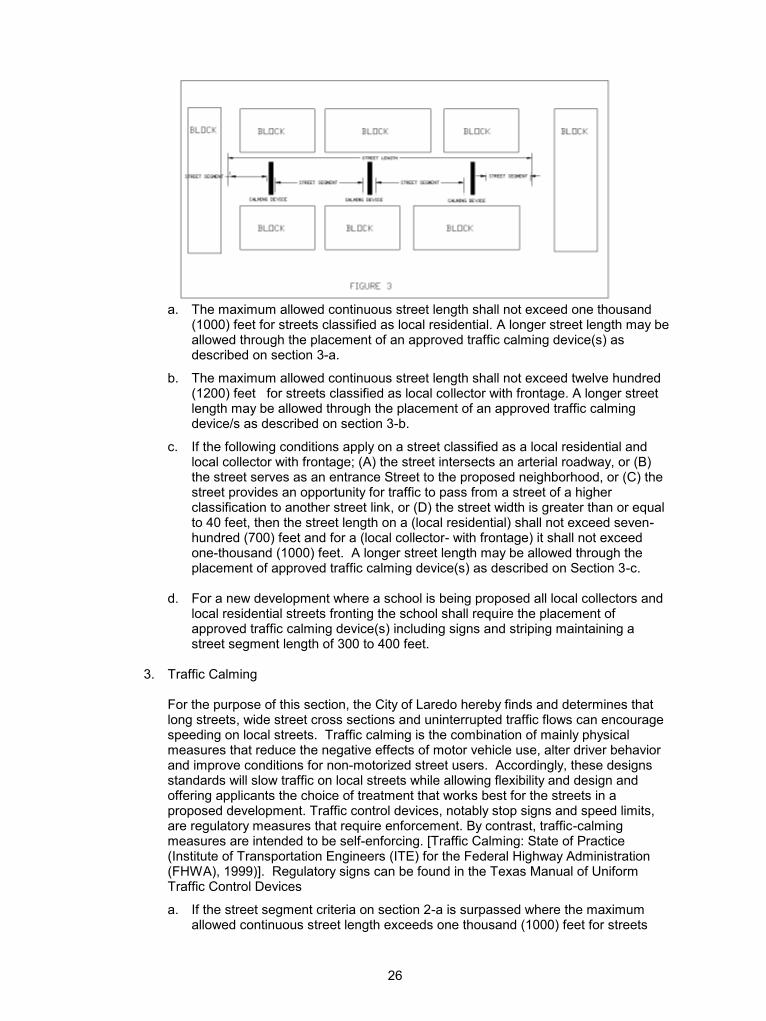
For the purposes of this ordinance, street length shall mean the distance following the centerline of the intersecting centerlines of the improved roadway between traffic control devices or cul-de-sacs that halt vehicular movement (FIGURE 1), except for L-shaped type intersections. L-shaped (elbow type) intersection shall mean the intersection formed by the roadway centerlines of two different non-continuous street lengths where the interior angle formed by these intersecting street lengths is not less than 72 degrees and not greater than 120 degrees (FIGURE 2). Each leg of an L-shaped (elbow type) intersection will be considered as separate street sections in determining street length. Street segment shall mean the sections of the street length that result from the placement of traffic calming devices (FIGURE 3).
26
a. The maximum allowed continuous street length shall not exceed one thousand
(1000) feet for streets classified as local residential. A longer street length may be allowed through the placement of an approved traffic calming device(s) as described on section 3-a.
b. The maximum allowed continuous street length shall not exceed twelve hundred (1200) feet for streets classified as local collector with frontage. A longer street length may be allowed through the placement of an approved traffic calming device/s as described on section 3-b.
c. If the following conditions apply on a street classified as a local residential and local collector with frontage; (A) the street intersects an arterial roadway, or (B) the street serves as an entrance Street to the proposed neighborhood, or (C) the street provides an opportunity for traffic to pass from a street of a higher classification to another street link, or (D) the street width is greater than or equal to 40 feet, then the street length on a (local residential) shall not exceed seven-hundred (700) feet and for a (local collector- with frontage) it shall not exceed one-thousand (1000) feet. A longer street length may be allowed through the placement of approved traffic calming device(s) as described on Section 3-c.
d. For a new development where a school is being proposed all local collectors and
local residential streets fronting the school shall require the placement of approved traffic calming device(s) including signs and striping maintaining a street segment length of 300 to 400 feet.
3. Traffic Calming For the purpose of this section, the City of Laredo hereby finds and determines that
long streets, wide street cross sections and uninterrupted traffic flows can encourage speeding on local streets. Traffic calming is the combination of mainly physical measures that reduce the negative effects of motor vehicle use, alter driver behavior and improve conditions for non-motorized street users. Accordingly, these designs standards will slow traffic on local streets while allowing flexibility and design and offering applicants the choice of treatment that works best for the streets in a proposed development. Traffic control devices, notably stop signs and speed limits, are regulatory measures that require enforcement. By contrast, traffic-calming measures are intended to be self-enforcing. [Traffic Calming: State of Practice (Institute of Transportation Engineers (ITE) for the Federal Highway Administration (FHWA), 1999)]. Regulatory signs can be found in the Texas Manual of Uniform Traffic Control Devices
a. If the street segment criteria on section 2-a is surpassed where the maximum allowed continuous street length exceeds one thousand (1000) feet for streets

27
classified as local residential, a traffic calming device(s) including signs and striping, designed and duly approved by the City of Laredo for this roadway classification, shall be installed. When required, traffic calming devices shall be installed to maintain street segments of 450 to 650 feet for local residential streets.
b. If the street segment criteria on section 2-b is surpassed where the maximum allowed continuous street length exceeds twelve hundred (1200) feet, for streets classified as local collector with frontage a traffic calming device(s) including signs and striping, designed and duly approved by the City of Laredo for this roadway classification, shall be installed. When required, traffic calming devices shall be installed to maintain street segments of 500 to 800 feet for local collector with frontage.
c. If the street segment criteria on section 2-c is surpassed where the maximum allowed continuous street length exceeds seven hundred (700) feet for local residential and one thousand (1000) feet for local collectors with frontage, for streets classified as local residential and local collector respectively a traffic calming device(s) including signs and striping, designed and duly approved by the City of Laredo for this roadway classification, shall be installed. When required, traffic calming devices shall be installed to maintain street segments of 300 to 400 feet.
d. L-shaped (elbow type) intersections, shall require a traffic calming device if the street length to the center of the intersection, measured from the point where the projection of the center lines for the two street sections intersect, exceeds 600 feet. Each leg of an L-shaped (elbow type) intersection will be considered as separate street sections. When required, the traffic calming device(s) shall be installed a maximum of 400 feet from the center of the L-shaped (elbow type) intersection. Any proposed street section that includes an L-shaped intersection shall be measured, for determining street section length, beginning at the center of the intersection. L-shaped intersections with interior angles less than 72 degrees will not be permitted. Intersections with interior angles greater than 120 degrees will not be considered as L-shape (elbow Type). Where the interior angle exceeds 120 degrees, a smooth curve roadway design with a minimum radius conforming to the standards for the particular geometric section shall be used. Where two L-shaped (elbow type) intersections are used to determine the street length, street length shall not exceed 1000 feet. A longer street length may be allowed through the placement of an approved traffic calming device(s) at distances described on section 3-a.
e. In the event traffic calming is necessary on a roadway adjacent to a school, a raised platform is encouraged and shall be located so as to be utilized as a crosswalk.
f. All required traffic calming devices shall be located a minimum of 150 feet from any intersecting street, cul-de-sac, and L-shaped elbow type intersections (Except those devises specifically designed for intersections and crosswalks).
g. The driveway location for lots affected by any proposed traffic-calming device
shall be clearly identified in the plat during platting process to restrict driveway location to that particular location. Modification of lots fronting a proposed traffic-calming device may also be required so as to minimize impact to these residential lots.
h. When a series of traffic calming devices need to be installed, the same type of
device(s) may be required to be used for a particular street or area. Under special circumstances, the exact placement of any required traffic-calming device,
28
outside the above-mentioned requirements, shall be subject to the review and approval of the Traffic Safety Department.
i. The intersection approaches requiring the installation of a stop sign(s) shall
require review and approval by the Traffic Department. j. The following provisions describe and establish standards for permitted traffic
calming devices where traffic calming measures, for local streets and local collectors, are required by the City of Laredo as part of the roadway design for new subdivisions. The descriptions set forth herein are described in the document entitled R. Ewing, Traffic Calming: State of Practice (Institute of Transportation Engineers (ITE) for the Federal Highway Administration (FHWA), 1999), which document is hereby incorporated by this reference. Defined traffic calming options for local and local collectors for the City of Laredo are noted below: These design standards and others that may be referenced in the document entitled R. Ewing, Traffic Calming: State of Practice (Institute of Transportation Engineers (ITE) for the Federal Highway Administration (FHWA), 1999) which will allow flexibility in design and offering applicants the choice of treatment that works best for the streets in a proposed development subject to the review and approval by the City of Laredo.
(1) Chicane - curb extensions that alternate from one side of the street to the
other, forming S-shaped curves. (2) Speed Table - flat-topped speed humps often constructed with brick or other
textured materials on the flat section. (3) Traffic Circle - raised islands, placed in intersections, around which traffic
circulates. (4) Raised intersection platform-flat raised areas covering entire intersections,
with ramps on all approaches and often with brick or other textured material on the flat section.
(5) Temporary Traffic Calming Device – This device is to be used in special
circumstances upon approval by the City of Laredo Traffic Engineer where a temporary solution is applicable. It could be in any form or shape as the devices listed above and shall conform to the norms and specifications listed in the specification book. This temporary traffic-calming device will have the distinctiveness of being easy to install and to remove and use a rubber type material that can withstand the natural elements and the constant strain caused by motor vehicles. It is strictly for temporary use and is the responsibility of the developer to maintain it until a decision is made to install a permanent or removal of the calming devices.
Specification for these devices can be found in the City of Laredo Standard
Technical Specification Manual. O. Pedestrian crosswalks, not less ten (10) feet wide, shall be required where deemed
essential to provide circulation, or access to schools, playgrounds, shopping centers, transportation and other community facilities.
P. Street signs and traffic control devises shall be approved by the Director of Traffic Safety
and provided in accordance with the City of Laredo Specification Manual. Q. Valley Gutter: 5 ft. wide as specified by City of Laredo Engineering Department.

29
R. Pavement Standards.
(1) Pavement Structure. The design of pavement structures shall be in accordance with the American Association of State Highway and Transportation Officials (AASHTO) Guide for Design of Pavement Structures latest approved edition. The pavement design report shall be prepared and signed by, or under the supervision of, a professional engineer registered in the State of Texas. The design requirements in (3) below shall be used for pavement design.
(2) Length of Service Life. Pavement shall be designed for a twenty-year service life. (3) Traffic Load, Reliability and Pavement Structures. The traffic load is the cumulative
expected 18-Kip equivalent single axle loads (ESAL) for the service life. The following 18-Kip ESAL Reliability Level and Pavement Structure shall be used in the design of streets for each street classification:
Pavement Specifications for Public and Private Streets
Street Classification 18-KIP
ESAL
Reliability
Level
Minimum
Pavement
Structure
Maximum
Pavement
Structure
Major, Minor Arterials,
Industrial Collector 3,000,000 R-95 SN = 3.80 SN = 5.76
Major Collector, Industrial
Street 2,000,000 R-90 SN = 2.92 SN = 5.08
Local Collector 1,000,000 R-70 SN = 2.58 SN = 4.20
Local street and access
easements intended for
primary access to a proposed
lot or building. 100,000 R-70 SN = 1.98 SN = 3.18
Traffic loads for major arterials, minor arterials, major collector and local collector
streets shall include bus traffic. (4) Serviceability. The serviceability of a pavement is defined as the pavement's ride
quality and its ability to serve the type of traffic (automobiles and trucks) which uses the facility. The initial serviceability index (p0) for flexible pavements shall be 4.2 and for rigid pavement shall be 4.5. The minimum terminal serviceability index (Pt) for local streets shall be 2.0 and for collectors and arterials shall be 2.5. A standard deviation (S0) for flexible pavement shall be 0.45 and for rigid pavement shall be 0.35.
(5) Roadbed Soil. A soil investigation must be performed for the design of pavement
structures. The number of borings and locations shall be sufficient to accurately determine the stratum along the route. Any existing soil information that is available either from the city or from private sources will be evaluated and, if determined to be applicable and valid, will be allowed in place of new soil tests.
Roadbed soil having a plasticity index (P.I.) greater than twenty (20) shall be treated
with lime to reduce the P.I. below twenty (20). Application rate of lime shall be determined based on laboratory testing. In no case shall the lime be less than fifteen (15) pounds/S.Y. for six (6) inches of lime treated subgrade. Lime treated subgrade will be included as a "structural layer" within the pavement design calculations. Proposals for stabilization alternatives in place of the use of lime will be considered
30
upon submittal of an engineering report verifying adequate stabilization of the highly plastic soil (particularly in soils high in sulfates where lime and cement are deemed inappropriate).
Where the roadbed is in a rock excavation a "structural layer" within the pavement
design calculations can be used that is equivalent to a structural layer for lime stabilized subgrade. If a roadbed structural layer is used in the pavement calculation for rock subgrade an engineering report will be provided to public works addressing the consistency of the subgrade prior to base placement.
(6) Pavement Layer Material. Alternative pavement materials may be used where the
existing soil or subsurface conditions, or the alternative materials, provide a level of drivability comparable to the materials otherwise required by this section. Proposals for alternative pavement materials with supporting engineering documentation may be submitted to the city for consideration for use. The combination of the following materials will be allowed for pavement structure:
a. Lime treatment for subgrade. b. Flexible base (crushed limestone or caliche). c. Prime coat. d. Tack coat. e. Hot mix asphaltic concrete pavement. f. Asphalt treated base. g. Reinforced concrete. h. Base reinforcement (Geogrids).
The City Engineer or his appointed agent, in accordance with the standards provided herein, must approve the pavement combination.
(7) Minimum Layer Thickness (Compacted). If the following components are utilized in
proposed pavement sections, the minimum thickness for the components shall be:
a. Hot mix asphaltic concrete pavement shall not be less than one and one-half (1 1/2) inches thick for surface course (Type D).
b. Hot mix asphaltic concrete pavement shall not be less than two and one-half (2 1/2) inches thick for a leveling-up course (Type B).
c. Asphalt treated base shall not be less than four (4) inches thick. d. Flexible base shall not be less than eight (8) inches thick. e. Lime treatment for subgrade shall not be less than six (6) inches thick.
(8) Curb and Gutter. Concrete curbs or monolithic curbs and gutters constructed in
accordance with the City of Laredo standard details shall be provided where indicated on the typical cross sections and shall conform to the City of Laredo Standard Specification Manual. Where the street upon which the lot or lots abut is a state numbered highway as defined in the Texas Highway and Public Transportation Commission Regulations of the Texas Administrative Code, and has a rural design or cross section, the owner of the lot or lots shall not be obligated to construct curb and gutter adjacent thereto, provide security in lieu of construction, or place the cost of said improvements in a trust account for the City's cost of said improvements when the abutting street is converted to an urban design.
(9) Medians and Dividers. Medians and dividers having curbs shall be constructed in
accordance with the approved cross section. Where divider strips on primary and secondary streets are constructed without curbs, they shall be graded to a slope of one-quarter (0.25) inch per foot from the center of the divider strip to a point seven (7) inches from above the edge of pavement and from that point to the edge of pavement.
31
(10) Arterials. Arterial slopes shall be one-quarter (0.25) inch per foot toward the street except in heavy cuts, where a maximum of one (1) inch per foot shall be permitted. Landscaping, walls or fences placed in the parkway for aesthetic purposes shall not obstruct sight distance.
(11) Intersections within industrial parks, truck routes, and industrial collectors. Turning
locations and queuing lanes at intersections shall be constructed using reinforced concrete.
Section 3.3: Lots and Lot Arrangement A. The lot size, width depth, shape and orientation, and the minimum building setback lines
shall be in conformance of Dimensional Standards established in the Laredo Land Development Code
B. Corner lots for residential use shall have extra width to permit appropriate building
setback from and orientation to both streets. C. Each lot shall be provided with adequate access to an existing public street by frontage
along such street or through connection of a new street or a permanent easement to an existing street.
D. Double frontage, reverse frontage lots, should be avoided except where essential to
provide separation of residential development from traffic arteries or to overcome specific disadvantages of topography and orientation. A planting screen easement of at least ten (10) feet, or a fence at the property line, and across which there shall be no right of access, shall be provided along the line of lots abutting such a traffic artery or other disadvantageous use. A residential service road is not considered a traffic artery for these purposes. Where such a planting screen or fence does not allow access for the adjacent residences, the right-of-way normally maintained by the adjoining property owner becomes the responsibility of the city to maintain if within city limits.
E. Side lot lines shall be substantially at right angles or radial to street lines. If possible, the
placing of adjacent lots at right angles to each other shall be avoided. F. Monuments:
1. Monuments shall be placed properly and referenced at all block corners, at all subdivision boundary corners and angle points, points of curves in streets, and at intermediate points as shall be required by the City Engineer. The description and location of all blocks corners and permanent survey monuments shall be shown on the plat. Such corners and monuments shall meet the following standards:
(a) Lot corners need not be marked with monuments; however, marking of same
shall be done as required by the private engineer and/or owner. (b) All block corners shall be marked with concrete monuments and property
referenced. Block angle points and intermediate points shall be marked with concrete monuments as required by the City Engineer.
(c) Concrete Monuments: Monuments shall have a 1/2 inch diameter by 12 inches
long iron rod centered and imbedded in a 6 inch diameter by 24 inches long concrete cylinder. This iron rod shall be flush with the top of the concrete cylinder and the cylinder buried firmly in place at least 12 inches below existing ground surface.

32
Where concrete monuments will be covered by concrete sidewalks or obliterated during construction, the private engineer shall coordinate with the City Engineer for approval of alternative methods of subdivision monumentation.
Alternative methods of subdivision monumentation include but are not limited to
(1) spike, tin and washer, (2) 1/2" diameter brass rings, (3) lead and tag, etc. Monumentation may be placed on an offset from the required location; however, the private engineer must obtain prior approval from the City Engineer.
(d) Accuracy of Survey: Closures of all boundary survey work and survey work within
the subdivision shall be within an error of one in seven thousand five hundred (1/7500).
(e) Project engineer shall submit to the City Engineering one copy of the recorded
subdivision plat showing all monuments installed and reference points.
Section 3-4: Easements
A. Rear Lot Utility Easements: Easements across lots or centered on rear lot lines shall be provided for utilities where necessary and shall be at least twelve (12) feet wide. Utility easements centered on side lot lines shall be at least ten (10) feet wide. If the required easement is along a plat boundary with adjacent unplatted land, or platted land, or platted with an adjacent utility easement, the minimum rear lot easement width required is six (6) feet, the minimum side lot easement is five (5) feet. Such easements may be required across parts of lots other than as described above upon recommendation of the City Engineer or Utilities Director. (As Amended 12/4/84, Ordinance # 84-0-199)
B. Front Lot Utility Easements: The developer of a residential (single family R-1 or R-1A)
subdivision, may, in his/her sole discretion, choose to locate utilities (electric, gas, telephone and cable) within the front yard setbacks of the lots within the subdivision in an easement that is six feet wide being no less than four feet from the front property line and no more than ten feet from the front property line of each lot and meet the following minimum requirements. (As Amended 8/20/12, Ordinance # 2012-O-108)
1. All transformers, pedestals, boxes or any other distribution boxes or pedestals shall be
placed within the easement and shall be centered on the side yard property line with the transformers placed nearest to the street and pedestals or other boxes aligned behind the transformer box.
2. A developer who chooses to place utilities (electric, gas, telephone and television/internet,
cable) in the front of the lots of a residential subdivision shall submit the utility layout/schematics at the same time the preliminary plat is submitted and shall clearly show on the preliminary and final plat the location of the front of lot utility easement
3. Trenches shall be not more than twenty-four inches wide nor more that forty-eight inches
deep. 4. Only AEP primary and secondary cable shall be placed at the forty-eight inch depth and
covered with twenty-four inches of fill. 5. Telephone, Cable and Gas shall be placed twenty-four inches below grade within the
same trench. 6. All back fill shall be at 95% compaction or as set out in the Standard Technical
Specification Manual, flowable backfill may be used if it meets the following:

33
A. Cement. Portland Cement shall conform to the requirements of the latest revision of ASTM Designation C150, Type 1, or Type II. Only one brand or kind of cement shall be used in any one structure or trench except as permitted in writing by the City Engineer. All cement shall be delivered in bags plainly marked with the brand and name of the manufacturer.
B. Fine Aggregate. Provide fine aggregate that will stay in suspension in the mortar to
the extent required for proper flow and that meets the gradation requirements of the aggregate gradation chart below.
Test fine aggregate gradation in accordance with Tex-401-A. Plasticity Index (PI) must
not exceed 6 when tested in accordance with Tex-106-A. C. Mixing Water. Use mixing water conforming to the requirements of TxDOT Item 421,
“Hydraulic Cement Concrete.” 7. One Sewer tap/service line shall be centered on each lot. 8. The utility easement may extend into the lot along the side yard property line so long as it
centered on the side yard lot line and does not extend past the side yard setback line (being five feet on each side of the side yard lot line) to a point where it intersects with the projection of the front of the house’s foundation. This additional easement extension is to be used for the utilities service lines to the house.
9. The developer and builders shall ensure that driveways are not constructed on the same
side of the lot where a transformer has been or will be placed. 10. In the event of any conflict t between the above requirements and the City of Laredo
Standard Technical Specification Manual, the Standard Technical Specification Manual shall control.
C. All utilities shall be designed and installed in conformance with the City Of Laredo
Standard Technical Specification Manual, as amended from time to time and [Standard Specification Manual] upon the approval of the Utilities Director and City Engineer.
Where the subdivider installs the utilities with private contractor, all the engineering
covering plans and specifications shall be accomplished by him and approved by the Engineering Department of the City of Laredo prior to the start of any installation. All engineering work shall be accomplished by persons qualified under State of Texas laws to do such work.
It shall be at the discretion of the City whether construction of sewer and water lines within
the subdivision will be contracted to private companies or whether City forces will accomplish the installations.
D. The Director of Utilities shall provide the Commission with a statement that the proposed
water and sewer system for the subdivision meets their current engineering standards for water and sewer service, prior to Commission approval of the subdivision.
E. As the City of Laredo has rights to the water of the Rio Grande to only a limited extent,
and that it is expected that the City's demand for water will exceed its supply within the planning period that this document addresses, the following is required:
All subdivisions within the jurisdiction of this ordinance, and outside the Laredo city limits
as of the date of passage of this ordinance, shall provide to the Laredo Utilities Department those water rights (or money in lieu thereof) that are fair and equitable for the creation of any additional lots that the system will have to serve.

34
Section 3-5: Laboratory Testing All materials to be used in new land development construction shall be subject to testing. The preponderance of testing to be performed in new developments is directly related to public improvement construction, and a series of laboratory tests normally associated with public improvement construction will be required in new developments. Said tests shall be performed by an independent testing laboratory using qualified personnel. The testing laboratory may be selected by the developer no more than five working days from the date of final plat approval by the Planning and Zoning Commission. Selection shall be submitted to the City Engineer in writing from a list of testing laboratories approved by the City. In the event no qualified laboratory is selected within the specified time period, the testing laboratory shall be selected by the City from the approved list on a rotational basis. Changing of laboratory firm, once selected, shall be prohibited. If unforeseen circumstances arise, and an alternative laboratory is required, the replacement laboratory shall be selected by the City Engineer from the list of approved laboratories on a rotational basis. The testing laboratory shall bill directly to the developer. It is assumed that the preponderance of testing required in the development is that testing related directly to street construction. For this reason, the following ratio of testing is established: RATIO OF TESTING: Subgrade ....................................... Minimum 1 per 150 feet of street Under curb and gutter .................... Minimum 1 per 150 feet of curb Caliche Base .................................. Minimum 1 per 150 feet of street Lime stabilized base ...................... Minimum 1 per 150 feet of street Sand base ...................................... Minimum 1 per 150 feet of street Backfill density control ................... Minimum of 10 (10) PROCTOR (MOISTURE/DENSITY RELATIONSHIP): Subgrade (new) ......................... 1 per development, unless material changes Lime stabilized base .................. 1 per development, unless material changes Caliche ....................................... 1 per 5,000 cubic yards material or less ATTERBERG LIMITS AND GRADATION: Caliche ....................................... 1 per 5,000 cubic yards material Sand base .................................. 1 per 2,500 cubic yards material HOT-MIX CONTROL: Surface course design ............... 1 per development Base course design ................... 1 per development Extractions ................................. 2 per day run/minimum 1 per 500 ton Densities (in place) .................... 1 per 1,000 feet of street CONCRETE: Curb/gutter ................................. 1 set (3) per 500 feet Sidewalk..................................... 1 set (3) per 4,000 square feet Inlets .......................................... 1 set (3) per 6 inlets
35
The above schedule is a minimum schedule for testing, failures are not included. In the event of failures, additional tests will be taken. If excessive rain occurs on a previously tested section, the City shall have the right to order re-testing as necessary. The contractor shall notify the City of Laredo Engineer at least twenty-four (24) hours prior that he is ready for testing, and the City's representative shall inspect the work and concur with the Contractor before testing can be authorized. The City Engineer or its representative shall notify the testing laboratory when tests are to be taken. In the event that neither the City Engineer nor its representative is available for inspection of the work within four (4) hours, the contractor may order the laboratory testing. Provided; however, in the event of failures, re-testing shall be at the contractor's expense. Except as otherwise provided above, it is the intent of the City that the contractor not contact the laboratory for the purpose of requesting routine test. The scope of materials incorporated in new development construction is not necessarily limited to those tests outlined herewith. In the event of unusual conditions or factors which may give the City reason to question the quality of the materials in any portion of the development, the City will have the right to order such tests as are necessary at the developer's expense. However, the City will consult with the project engineer on reasons for such additional tests before a testing laboratory will be asked to conduct such test. All testing in accordance with these requirements will be performed in accordance with the American Society of Testing Materials (ASTM) latest revision, and/or as elsewhere provided unapproved plans and specifications for the development. The City will require all development test reports to be certified by a Registered Professional Engineer (Texas Registration) and will further require that the City be furnished a minimum of two (2) copies of testing reports. Further, the project engineer shall provide the City for the testing laboratory a set of plans and specifications as well as a tabulation showing the estimate of quantities of material in the development. Section 3-6: Street Lighting All new subdivisions (excluding replats of tracts where the below standards are met) shall be provided with street lighting, and a plan for the installation of street lighting in conformance to the standards below shall be presented to the Director of Traffic Safety for approval prior to final plat submittal in conformance to the following standards: Arterial streets = 27,000 Lumens approximately every 300 feet of street length. (Amended 4/6/92, Ordinance # 92-0-080)
All other streets = 16,000 Lumens approximately every 300 feet of street length. (Amended 4/6/92, Ordinance # 92-0-080)
Minor variations in positioning of lamp poles due to lot and block configuration may be allowable with the approval of the Commission. On streets that serve as exterior boundaries of the subdivision, the Commission may allow alternate spacings for lamp poles, where the adjacent land can be expected to develop and provide for its alternate half of the Street Lighting. Installation and the first year's electricity costs shall be borne by the owner, and considered as a utility cost for bonding requirements (or alternative guarantees as may be allowed). (As amended 10/30/84, Ordinance # 84-0-178)
Section 3-7: Lot Grading

36
Lot grading in developments will be such that lots drain toward the street. Accordingly, all lots graded within developments will be sloped such that a minimum grade of one-half of one percent exists from the property lines to the rear of the lot. In the event it is not practical to drain lots to the street (rear to front) then an alternate drainage plan may be submitted for approval by the City of Laredo Engineering Department. If drainage from adjacent property crosses such development, drainage from adjacent property will be physically diverted to adequate drainage facilities or handled with the run-off from the development itself. A lot grading plan shall be made part of the final plans and shall be considered an improvement for the development. Construction of same shall be a condition precedent to the final acceptance of the development by the City Engineer. Section 3-8: Commercial Condominium Design Standards For purpose of this ordinance, a commercial condominium is defined as development where the land under each commercial unit is owned by the building owner(s) and common parking, ingress, egress, easements and landscaped areas are owned and maintained by a condominium association. Standards: 1. Minimum development size shall be 31,000 square feet. 2. Minimum commercial unit (lot) size shall be 1,000 sq. ft. 3. Minimum ratio of floor area to common area 1:2. That is for every square foot of floor
area, there shall be at least two (2) square feet of common area. 4. Utility easement requirements, design and specifications for public and private utility
distribution are subject to approval of the City. In the absence of written approval, a minimum twelve (12) foot utility easement is required along the outside perimeter of the land to be platted to provide services to this development and future development.
5. At least five percent (5%) of the common area shall be devoted to landscaping and
maintained by the condominium association. 6. The common area shall have at least two separate curb cuts to a public street. 7. A condominium association shall be formed, and, the association agreement shall be,
with the City's concurrence, filed simultaneously with the final plat with the County Clerk's records. The association agreement shall contain binding provisions between the property owners for the allocation of costs and responsibilities associated with the common area. (As amended 4/21/86, Ordinance # 86-0-074)
Section 3-9: Electrical Service It shall be required for final plats approved after December 31, 1992 that all single-phase electrical service in new subdivisions of land be installed underground in accordance with the underground service policy of the electric utility, except that service to the perimeter lots may be underground from overhead facilities. Primary, secondary and street light conductors shall be located in dedicated utility easements located adjacent to rear or side lots lines.

37
CHAPTER IV
EXCEPTIONS, ENFORCEMENT, VALIDITY Section 4-1: Exceptions A. Deleted by Ordinance #: 85-0-102, 7/2/85. B. Where a replat is proposed in the Eastern or Western Division of the City of Laredo and
the land area proposed for a replat is less than 20,000 square feet, the following exceptions to the ordinance apply:
A. Provision by the developer for sidewalks, landscaping, and street lights elsewhere
required by the ordinance, are optional: and, B. In cases where a street has been opened for traffic and said street contains a substantial
base of caliche or gravel, then and in that event in lieu of immediate street paving, the present record owner or owners of abutting properties shall be required by the City of Laredo to file or cause to be filed at the County of Webb Deed Record Office a covenant running with the land binding the present record owners, their heirs, devises, successors and assigns to join, participate and pay any corresponding share of paving costs of any future street paving assessment program involving said street along said abutting properties. Thereafter, said assessments when made shall constitute a lien on the property until fully discharged. (As amended on 7/2/85, Ordinance # 85-0-98)
C. Any mobile home park, in existence on January l, 1984 may be subdivided into lots if the
mobile home park was designed and built in accordance with mobile home park standards set forth by the Land Development Ordinance in effect at the time the mobile home park was constructed and the following subdivision standards are fully complied with: (As amended 8/21//84, Ordinance # 84-0-128)
1. All lots shall have access to street right-of-way at least 30 feet wide dedicated to the
public; 2. Street paving of at least 30 feet back-of-curb to back-of-curb; 3. Street construction according to City Standards, except the Street may be either roll
over or high back curb and gutter; 4. Four feet wide sidewalks constructed to City standards, along at least one side of
street rights-of-way. 5. Cul-de-sac raddii of at least 40 feet; 6. Minimum 4,000 square feet lots; 7. Easements at least 12 feet wide for all utilities, unless the utility is located in the
street, which is together with the utility easement, at least a fifty (50) foot right-of-way. 8. Water, sewer, drainage, street lights, street name signs and all other Subdivision
Ordinance requirements except as stated under this section. After any subdivision of a mobile home park, there shall be a three year period during
which subdivided lots may be rented.
38
D. Where there is proposed to be platted a subdivision or resubdivision of land to be used for residential purposes, there may be dedication of less than fifty (50) feet in width of residential right-of-way adjacent to or within the proposed subdivision, if said right- of-way is part of Ejido Avenue between Cortez Street on the south and the Tex-Mex Railway right-of-way on the north, is at least thirty (30) feet wide, and results from a conveyance by the City prior to the adoption of the Subdivision Ordinance of 1961.
The Planning Commission may accept, according to the provisions of this subsection, the
subdivision or resubdivision of land, with less than fifty (50) feet of width of abutting or internal right-of-way, only if said right-of-way is to be used as a local residential street as defined by Section 3-3 (A) (4) herein. (As amended 4/20/87, Ordinance # 87-0-64)
Section 4-2: Enforcement
In order to ensure that the development of any property within the Jurisdiction of this ordinance is completed in a manner that follows the purpose of guiding and accomplishing a coordinated, adjusted, and harmonious development of the City of Laredo, and to insure the public welfare, the following standards shall be followed. These standards are in addition to the design specifications required by either the City Engineering Department or the Laredo Waterworks and Sewer Systems. The standards are as listed below. A. No land shall be used for a purpose prohibited by any restrictive covenant, inscribed on
the plat as approved by the Planning and Zoning Commission, nor shall any land be used that is not in accordance with the regulations of this ordinance.
B. No building shall be erected, converted, enlarged, reconstructed or structurally altered or
moved for a purpose or purposes prohibited by covenants incorporated as plat restrictions and approved by the Commission.
C. No building shall be erected, nor moved, nor shall any permit be issued for an
improvement by the Building Official, on a parcel of land, except on a lot as platted in accordance with these regulations.
D. No building shall be enlarged except on a lot as platted in accordance with these
regulations. E. No building affected by fire, flood, wind, or other disaster shall be reconstructed beyond
fifty (50%) percent of its present floor area except on a lot as platted in accordance with these regulations.
F. Unless and until any such plan, plat, or replat shall have been first approved in the
manner and by the authorities provided for in this ordinance, it shall be unlawful within the area covered by said plan, plat, or replat for any officials representing the City of Laredo to serve or connect said land or any part thereof, for the use of the owners or purchasers of said land or any part thereof, with any public utility which may be owned or controlled or distributed by the City of Laredo.
G. The acceptance of a final plat by the City of Laredo does not, in any manner, obligate the
City to finance or furnish any storm sewers, drainage structures, or street or water or sewer improvements or any other improvements within the approved subdivision. Expenditure of public funds for these purposes must be approved by ordinance passed by the City Council of the City of Laredo. (As amended 4/20/87, Ordinance # 87-0-83)
H. The Building Official may issue a permit, on a parcel of land, not platted in accordance with these regulations if and only if:
39
1. The permit is for the repair or improvement of an existing single family residential structure located within the City, provided however that such repair or improvement would not further encroach in any building setback, except upon the approval of a variance from the Board Adjustments.
2. Any permit request to remedy a residence unsafe as per Section 103.2, Unsafe
Residential buildings, of the Standard Housing Code by the Southern Building Code Congress International, Inc.
3. The permit is for construction on an Oil and Gas exploration or extraction site after the
issuance of a Special Use Permit by the City Council of the City of Laredo as outlined in Section 24-79, Special Use Permits, of the City of Laredo Zoning Ordinance.
4. The permit is for the removal of a mobile-home, or the demolition of a house, or
building. 5. The permit is for improvements or construction on city owned property for which a
public purpose is intended, specifically a park or utility enhancement. 6. A building permit, permit for electricity or permit for other construction related services
may be issued for the construction of improvements by a political subdivision of the State of Texas on property (for which a public purpose is intended and there will be no resale of the property) which has received final plat approval by the Planning & Zoning Commission but the plat has not been recorded provided that the following criteria is met:
a) A resolution, order or ordinance has been approved by the governing body of the
political subdivision and said resolution, order or ordinance clearly guarantees that any public improvements shall be constructed in accordance with the plans and specifications as submitted to and approved by the Planning and Zoning Commission and the City (including all City departments which have review and approval authority).
b) A written request, accompanied by a certified copy of the resolution, order,
ordinance or certified minutes, has been submitted to the City Manager by the chief Executive Officer or Director of the political subdivision which clearly requests the issuance of a building permit, other permit for electricity or permit for other construction related services and reaffirms the political subdivision’s guarantee to complete the public improvements.
c) Once the City Manager has approved said request it shall be forwarded to the
City Council for approval. Once approved by the City Council building permits or other permits for electricity or other construction related services may be issued.
d) No certificate of occupancy shall be issued until all improvements have been
accepted by the City in writing and the approved plat has been recorded. 7. The permit is for improvements or construction on property that is a lot of record as
defined in Appendix A of the Laredo Land Development Code located in Eastern or Western Division. Excluded from this exception is a lot of record as defined by (ii) in Appendix A of the Laredo Land Development Code within one block of the intersection of any two arterials and/or collectors identified on the City of Laredo’s Major Thoroughfare Plan. (Created on 12/7/09, Ordinance # 2009-O-213)

40
CHAPTER V
MISCELLANEOUS
Section 5-1: Interpretation, Purpose and Conflict
In interpreting and applying the provisions of this ordinance, they shall be held to be the minimum requirements for the promotion of public safety, health, convenience, comfort, prosperity, and general welfare. It is not intended by this ordinance to interfere with or abrogate or annul any easements, covenants, or other agreements between parties, provided, however, that where this ordinance imposes a greater restriction upon the use of buildings or premises or upon height of buildings or requires larger open spaces than are imposed or required by other ordinances, rules, regulations, or by easements, covenants, or agreements, the provisions of this ordinance shall govern. Section 5-2: Enforcement; Procedure It shall be the duty of the Building Official to enforce this ordinance as related to the building construction to insure compliance with this ordinance. In case any building or structure is erected, constructed, reconstructed, altered, repaired, converted, or maintained or any building, structure or land is used in violation of this ordinance, the City, in addition to other remedies, may institute any appropriate action or proceedings to prevent such unlawful erection, maintenance, or use, to restrain, correct, or abate such violation, to prevent the occupancy of said building, structure or land or to prevent any illegal act, conduct, business or use in or about such premises. The Building Official shall not issue any permit for any development unless that development has a system for water supply and sewage disposal approved in accordance with this ordinance, and additionally has a street right-of-way compatible with the requirements contained herein. Section 5-3: Extraterritorial Effect of this Ordinance All portions of this ordinance pertaining to the subdivision of land shall apply both within the corporate limits of the City, and also within the extraterritorial jurisdiction of the City of Laredo. All of the ordinances pertaining to the erection, construction, enlargement, alteration, repair, moving, removal, demolition, conversion, occupancy, equipment, use, height, area and maintenance of buildings or structures within the City of Laredo shall apply to that area as amended from time to time which shall remain outside the corporate limits of the City of Laredo and yet within the extraterritorial subdivision authority of the City of Laredo, as may be agreed to through the process of covenant restrictions, as placed on subdivision plats, as outlined in this ordinance. Section 5-4: Penalty Any person who shall violate any of the provisions of this ordinance shall be deemed guilty of a misdemeanor and upon conviction thereof, by the corporation Court of the City of Laredo, shall be fined in a sum not exceeding five hundred dollars ($500), and each day such violation continues shall constitute a separate offense. Prosecution or conviction under this provision shall never be a bar to any other remedy or relief for violations of this ordinance. (Amended 4-7-98,
Ordinance # 98-0-091) Within the terms of the Municipal Annexation Act, the City of Laredo shall enjoin in the District Court any violation of any provision of this ordinance in the area outside the corporate limits of the City, but within its extraterritorial jurisdiction. (As amended 8/21/89, Ordinance # 89-0-154)

41
Section 5-5: Right of Appeal (Deleted 1/16/86, Ordinance #86-0-001) Section 5-6: Repealing Clause
Any ordinance inconsistent with the terms and provisions of this ordinance is hereby repealed; such repeal, however, is only to the extent of such inconsistency and in all other respects this ordinance shall be cumulative of other ordinances regulating the subject matter covered herein. Any inconsistency, however, shall not have the effect of reducing the requirements of those regulations pertaining to fire prevention, health, sanitation or safety of persons or property heretofore enacted by the City. If ever and whenever in this Ordinance, restrictions, prohibitions, or provisions conflict, and if this Ordinance conflicts with laws of the State of Texas, or with regulations of State or Federal Regulatory Bodies having jurisdiction, each instance the more restrictive restriction, regulation, prohibition or provision shall apply. Section 5-7: Filing Fee (Rescinded by Ordinance #93-0-22, 2/1/93) Section 5-8: Severability If any chapter, section, paragraph, subdivision, clause, phrase or provision of this Ordinance shall, for any reason, be adjudged invalid or held to be unconstitutional, the invalidity or non-constitutionality of such particular chapter, section, paragraph, subdivision, clause, phrase or provision so declared shall not affect the validity or constitutionality of the remaining provisions hereof, but the same, and each of them, shall remain in full force and effect. Section 5-9: Headings of Sections The headings of the several sections or chapters of this Ordinance are inserted for convenience only and shall not have any operative effect and shall not control or affect the meaning or construction of any of the provisions of this Ordinance. Section 5-10: Uniform Application and Enforcement The application and enforcement of this Ordinance shall apply uniformly to all property and citizens within the jurisdiction of this ordinance with the following points of clarification: A. Any reference to the issuance of building permits by the City Building Official shall apply
only to the City limits of the City of Laredo, except for those cases in which the property owner has so contracted through subdivision plat restrictions, or another legal instrument, to extend the authority of the City of Laredo to issue building permits for construction on his property.
B. Any reference to the authority of the City Engineer to inspect the construction of
necessary subdivision improvements shall apply both within the City limits of the City of Laredo and to the extraterritorial jurisdiction of the City of Laredo, except in those cases in which the property owner has so contracted with the City through subdivision plat restrictions, or another legal instrument.
C. Section 5-5 of Chapter V shall apply, as so written in that section, with different provisions
for penalties to violations of this Ordinance, depending upon whether the location of the violation was within or outside the city limits of the City of Laredo.

42
CHAPTER VI
AMENDMENTS AND CHANGES Section 6-1: Requirements The City Council may on its own motion or on petition, amend, supplement or change by ordinance the regulations established herein or subsequently established but no such amendment shall be made without a public hearing before the Planning Commission. The public hearing shall be recessed and continued to a time and date certain, to be not less than ten (10) days after the initial hearing after which second meeting; the Commission shall forward its recommendations to the City Council. Section 6-2: Notice Required Notice of the time, place, and purpose of the opening of the public hearing shall be given by publication once in the daily newspapers of the City, at least three days prior to the initial hearing. The notice shall explain in sufficient detail the nature of the proposed change(s) to the ordinance. PASSED BY CITY COUNCIL AND APPROVED BY THE MAYOR ON THIS THE 17TH DAY OF JANUARY 1984.