Embed Size (px)
Citation preview

Draft Supplementary Planning Document I March 2017
HAMPTON HILL


Contents
1. Introduction 2. Planning Policy and Wider Context 3. Spatial Context 4. Vision for Hampton Hill5. Objectives 6. Character Area Assessments
■ Character Area 1: Burtons Road ■ Character Area 2: St James’s Estate ■ Character Area 3: Links View Road and eastern end of Park Road ■ Character Area 4: High Street (Hampton Hill) Conservation Area ■ Character Area 5: Uxbridge Road South and Park Place ■ Character Area 6: Joanna Southcott Chapel Conservation Area
7. Features and Materials 8. Guidance for Development Sites 9. Shop Front Guidance 10. Forecourt Parking
Appendix 1: Relevant Policies and Guidance

4
1. Introduction
The purpose of this Village Planning Guidance Supplementary Planning Document (SPD) is primarily to establish a vision and planning policy aims for the area, in the light of existing and emerging Local Plan policy. The SPD intends to define, maintain and enhance the character of Hampton Hill, and to provide guidance in this regard. The SPD forms part of the wider Village Plan.
By identifying key features of the village, the SPD clarifies the most important aspects and features that contribute to local character to guide those seeking to make changes to their properties or to develop new properties in the area, as well as being a material consideration in determining planning applications.
The core of this SPD is a series of character area assessments for the component areas of Hampton Hill. These character areas have been identified through the similarity of key features that are deemed to define their individual local character. The assessments establish dominant features and materials as well as an overall description of the street pattern and housing types.
The London Borough of Richmond upon Thames has been divided into a series of smaller village areas. Each village is distinctive in terms of the community, facilities and local character – as are many sub areas within the villages.
The villages of the London Borough Richmond upon Thames are attractive with many listed buildings and Conservation Areas, the local character of each being unique, recognisable and important to the community and to the aesthetic of the borough as a whole.
Hampton Hill SPD Area Boundary

5
The boundary for the SPD is based on:
■ a review of how each area’s design characteristics can best be grouped;
■ taking account of physical and administrative boundaries, including conservation area boundaries to avoid these being split between village areas; and
■ how local communities viewed their local areas when asked through the Council’s 2010 ‘All-In-One’ survey and subsequent consultations.
This SPD has been produced by the Council working closely with the community. This has ensured that local residents, businesses and stakeholders have been genuinely involved in defining the important features – as well as the opportunities and threats – that define their local area.
The community has been involved through:
■ Drop in session at Hampton Hill Junior School on 5th March.
■ A resident walkabout held on 5th March 2016.
■ Online and hard copy questionnaire consultation from 5th February to 21st March 2016.
■ Stakeholder workshop at Hampton Hill Junior School 9th June 2016.
■ Online and hard copy questionnaire
consultation (statutory consultation) 9th September to 21st October 2016.
■ Drop in at Hampton Hill Junior School 1st October 2016.
Wider Context (Village Plans)
Village Plans have been developed for each of Richmond’s 14 villages. Each Village Plan describes a vision for the village area and identifies what the Council will do and what local people can do to achieve the vision together. It sets out the key issues and priorities and provides background information on the village area. The Village Plans are maintained on the Council’s website and are updated as projects are progressed. They cover a wide range of topics, including matters not within the remit of the SPD.
This Village Planning Guidance SPD forms part of the Village Plan by providing a formal planning policy document which can be used to guide new development that has responded to residents’ desire to have greater control and influence over planning and development decisions in their local area. The involvement of the local community in the production of the SPD has been essential in ensuring it is a genuine reflection of residents’ priorities. Hampton Hill drop in session, 1st March 2016

6
2. Planning Policy and Wider Context
2.1 Planning Policy Framework
National Planning Policy
The National Planning Policy Framework (NPPF) sets out the Government’s planning policies for England and how these are expected to be applied. The NPPF is a key part of the Government’s reforms to make the planning system less complex and more accessible. The NPPF provides the context for local planning authorities and decision takers, both when drawing up plans and making decisions about planning applications. It must be taken into account in the preparation of local and neighbourhood plans, and is a material consideration in planning decisions.
Regional Planning Policy
At a regional level, the London Plan is the overall strategic plan for London setting out an integrated economic, environmental, transport and social framework for the development of London over the next 20-25 years. This document has been adopted to ensure that a longer-term view of London’s development is taken when producing local plans, making planning decisions and investing in infrastructure.
Local Planning Policy
The London Borough of Richmond upon Thames current statutory planning policy framework is set out in adopted Plans including the Core Strategy, adopted in April 2009, and the Development Management Plan, adopted in November 2011. There is an online proposals map and a range of guidance provided through Supplementary Planning Documents (SPDs) and Supplementary Planning Guidance (SPG) for the area.
This SPD forms part of the planning policy framework and should be read in conjunction with the Council’s suite of planning policy and guidance as applicable. There is also a range of evidence base studies that the Council has undertaken which help to guide policy making.
The Council has progressed its Local Plan and in December 2016 approved the “Publication” version of the new Local Plan. This is the version of the plan which the Council intends to submit to the Secretary of State for Examination in 2017, following a 6 week period in early 2017 during which the public can comment on the “soundness” of the plan. The Publication Local Plan takes into account responses made during public consultation in summer 2016. Throughout the rest of this document this is referred to as the “Local Plan”.
The Local Plan has now reached a stage where it is given considerable weight in the decision making process, and is used in determining planning applications.
It is expected that the Local Plan will be adopted in spring 2018, at which point it will supersede all existing policies in the Core Strategy and Development Management Plan.
Alongside existing adopted planning policies, suitable references have been made to the equivalent policies in the Local Plan.
Up-to-date information on the Council’s Local Plan can be viewed at: http://www.richmond. gov.uk/home/services/planning/planning_ policy/local_plan.htm.

7
2.2 Key Planning Policies
SPDs cannot create new policies but expand on policies set out in higher plans, notably the LBRuT Local Plan (2017).
This SPD relates to a considerable number of higher policies, notably:
Policy LP 1: Local Character and Design Quality
The Council will require all development to be of high architectural and urban design quality. The high quality character and heritage of the Borough and its villages will need to be maintained and enhanced where opportunities arise. Development proposals will have to demonstrate a thorough understanding of the site and how it relates to its existing context, including character and appearance, and take opportunities to improve the quality and character of buildings, spaces and the local area.
Shop fronts
The Council will resist the removal of shopfronts of architectural or historic interest. Shopfronts, including signage and illumination, should complement the proportions, character, materials and detailing, surrounding streetscene and the building of which it forms part. Blinds, canopies or shutters, where acceptable in principle, must be appropriate to the character of the shopfront and its context within which it is located. External security
grilles and large illuminated fascias will only be allowed in exceptional circumstances. In sensitive areas, rigid and gloss finish blinds will generally be unacceptable.
Advertisements and hoardings
The Council will exercise strict control over the design and siting of advertisements and hoardings to ensure the character of individual buildings and streets are not materially harmed, having regard to the interests of amenity and public safety (including highway safety).
Within the existing Core Strategy (2009) the equivalent policy is Policy CP7 and in the Development Management Plan (2011) the equivalent policies are Policy DC1 and Policy DC7.
Policy LP 25: Development in Centres
Development in the Borough’s centres, as defined in the centre hierarchy, will be acceptable if it:
1. Is in keeping with the centre’s role and function within the hierarchy and is of a scale appropriate to the size of the centre (also see the Spatial Strategy of this Plan).
2. Is in an appropriate location.
3. Does not adversely impact on the vitality and viability of the centre in which the development is proposed, or another centre. When assessing
proposals for development outside of existing centres, applicants will have to comply with the requirements of national policy and guidance in relation to impact assessments. For retail developments, including extensions of over 500sqm gross, the Council will require a Retail Impact Assessment.
4. Optimises the potential of sites by contributing towards a suitable mix of uses that enhance the vitality and viability of the centre.
The full policy is set out in Appendix 1.
Within the existing Core Strategy (2009) the equivalent policy is Policy CP8.
Policy LP 3: Designated Heritage Assets
The Council will require development to conserve and, where possible, take opportunities to make a positive contribution to the historic environment of the borough.
The full policy is set out in Appendix 1.
Within the existing Development Management Plan (2011) the equivalent policies are Policy DM OS 1, Policy DM HD 1 and Policy DM HD 2.
Policy LP 4: Non-Designated Heritage Assets
The Council will seek to preserve, and where possible enhance, the significance,
character and setting of non-designated heritage assets, including Buildings of Townscape Merit, memorials, particularly war memorials, and other local historic features.
There will be a presumption against the demolition of Buildings of Townscape Merit.
The full policy is set out in Appendix 1.
Within the existing Development Management Plan (2011) the equivalent policy is Policy DM HD 3.
Policy LP 45: Parking Standards and Servicing
The Council will require new development to make provision for the accommodation of vehicles in order to provide for the needs of the development while minimising the impact of car based travel including on the operation of the road network and local environment, and ensuring making the best use of land. For example, this will be achieved by:
Resisting the provision of front garden car parking unless it can be demonstrated that:
a. There would be no material impact on road or pedestrian safety;
b. There would be no harmful impact on the character of the area, including the streetscape or setting of the property, in line with the policies on Local Character and Design; and

8
c. The existing on street demand is less than available capacity.
The full policy is set out in Appendix 1.
Within the existing Development Management Plan (2011) the equivalent policy is Policy DM TP 9.
A wider list of relevant policies can be found in Appendix 1.
It should be noted that all adopted policies and guidance should be assessed for their relevance in respect of individual planning applications, not just those referred to above.
2.3 Planning Policy Aims
This SPD reinforces the existing planning policy aims for Hampton Hill, and draws on the Local Plan. Planning policy seeks to achieve the following:
■ The distinctive local character of the area will be maintained and enhanced, including Hampton Hill’s listed buildings and Conservation Areas. New development, including associated open space and planting, will be of high quality design which respects and enhances the distinctive local character.
■ Hampton Hill High Street will continue to perform well and thrive, providing a good mix of shopping and other services to meet local needs. Shopfronts, signs and advertisements will maintain local character.
■ The loss of housing generally, and that which meets specific community needs, will be resisted, and new housing to meet local needs will be provided on appropriate sites.
■ Hampton Hill’s parks and open spaces and the Longford River will be protected, and enhanced where possible, for wildlife and recreation.
■ Land will be protected for employment use, including Key Office Areas at Hampton Hill Business Park and the northern part of the High Street.
■ The impact of new development on the transport network will be carefully considered, and appropriate provision for parking, walking and cycling will be made. The impact of through traffic and congestion will be managed and reduced where possible.
■ Front garden parking will be resisted unless there would be no harmful impact on the character of the area including the streetscape or setting of the property, as well as other considerations.

9
3. Spatial Context
This section covers transport, green spaces, shops and services which are an essential part of the village’s character. These are detailed below and, together with its historic assets, are mapped on the following pages.
Facilities in Hampton Hill
■ The High Street is the main retail frontage and supports a large number of national and independent shops.
■ The main cultural offer is Hampton Hill Theatre together with Hampton Hill Library, as well as a number of restaurants and public houses including the Windmill and the Bloated Mallard.
■ The only school within the area is Hampton Hill Junior School.
■ The main doctor’s surgery in the area is Hampton Hill Medical Centre, along with two dental surgeries, all located on the High Street.
■ There are a number of places of worship including St James’s Church, United Reformed Church and Hampton Hill Spiritualist Church.
Connectivity and accessibility
■ A number of bus routes including 285, R68 and R70 run through the High Street.
■ The High Street/A311 is the main transport route through the area, with the area also bounded by Park Road to the north and Uxbridge Road to the west.
■ Changes to bus stop locations in the High Street are being made as part of a wider scheme to improve congestion on the High Street.
■ The nearest rail links are Fulwell and Hampton, both outside the Hampton Hill area.
Green Infrastructure
■ Green spaces in the area include Holly Road Recreation Ground and the grounds surrounding St James’s Church.
■ Bushy Park sits behind the High Street.
■ Longford River runs through Bushy Park and through the Hampton Hill area running most notably along Windmill Road.

10
Connectivity and Accessibility in Hampton Hill
© Crown copyright and database rights 2014 Ordnance Survey 100019441
KEY

11
Facilities in Hampton Hill
High Street
Hampton Hill Theatre
© Crown copyright and database rights 2014 Ordnance Survey 100019441
St James’s Church
Hampton Hill Junior School
Hampton Hill Spiritualist
Church
Clarence House Prep
School
The Greenwood Centre
Hampton Hill Medical
Centre
Hampton Hill Theatre
United Reformed Church
Hampton Hill Library

12
Green Infrastructure in Hampton Hill
© Crown copyright and database rights 2014 Ordnance Survey 100019441
War Memorial
Longford River
Holly Road Recreation Ground
Pantile Bridge Green

13
Historic Assets in Hampton Hill
Note that Archaeological Priority Areas are recorded in the Development Management Plan.
Buildings Of Townscape Merit are not designated and are locally listed. Listed Buildings are designated and recognised nationally. Please note that these are correct at the time of adoption of the SPD. For the most up to date information please see the Council’s website.
Produced from our Corporate Geographic Information System© Crown copyright and database rights 2015. Ordnance Survey 100019441
Hampton HillPrinted: 11/07/2016
1:5,169Scale
Legend
Village_Boundary
Listed Buildings
Buildings of Townscape Merit
Borough Boundary
Conservation Areas
SPD Boundary
Produced from our Corporate Geographic Information System© Crown copyright and database rights 2015. Ordnance Survey 100019441
Hampton HillPrinted: 11/07/2016
1:5,169Scale
Legend
Village_Boundary
Listed Buildings
Buildings of Townscape Merit
Borough Boundary
Conservation Areas

14
4. Vision for Hampton Hill
Hampton Hill - a Pen Portrait
Hampton Hill is an established local centre providing a wide range of shops and services as well as small scale offices and the theatre. It maintains its village character, composed of Victorian shops (often converted from cottages), some listed houses, a picturesque backdrop of trees from Bushy Park and a pleasant arrangement of neighbouring residential streets. Further away from the High Street the area is residential with a predominantly Victorian and Edwardian character of uniform semi-detached homes in avenues of mature trees.
There are large open spaces to the north of the area (Twickenham and Fulwell golf courses), the east (Bushy Park) and to the south west (Longford River) and these very much define the Hampton Hill area. Green spaces, street trees and gardens are highly valued by local people as contributing to the character of the area.
In future Hampton Hill will continue to be a thriving local centre with a range of shops and community facilities to meet local needs through a good balance of independent shops(as well as multiples) supported
by sufficient convenient car parking. The appearance will be enhanced through improvements to buildings, particularly shop fronts and the public realm.
The impact of through traffic on the High Street and residential roads will if possible be reduced and facilities for both pedestrians and cyclists enhanced. Parking will be managed to ensure that residents can access their centre and enjoy the amenities of the area and its surroundings.
Identify local character – to identify local character and historic assets for enhancement or protection.
Promote high standards of design - through high quality illustrative material and simple guidance and advice to local residents and businesses.
Development Management – to set design guidelines for householders, developers and the Council (in relation to public realm) to encourage high quality development and, if possible, avoid the need to refuse development proposals.
Implementation of schemes – to provide advice for householders and businesses that will help them achieve repairs and modernisation which respects local character and where possible restore original details which have been lost during earlier modifications.
Design Review – to provide a framework for the Council to use in reviewing the effectiveness of planning and public realm decisions.
Local Policy Context - to identify policies in the Local Plan which are essential to addressing local issues.
A vibrant, caring community with a thriving High Street and community facilities to meet local needs.
The Hampton Hill Village Planning Guidance SPD has been developed to meet the following objectives, which correspond to those in the Council’s Design Quality SPD.
5. Objectives
14

15
6. Character Area Assessments
Character Area Plan
The identification of local character is one of the primary objectives of the SPD.
The character area assessments sub-divide the village into a smaller set of sub areas, some of which are further sub-divided.
Each area has been defined by grouping properties where a large proportion have similar characteristics, features and materials. These have been identified and recorded.
A number of the areas included within this section are adopted Conservation Areas. More information regarding Conservation Areas can be viewed at http://www.richmond.gov.uk/home/services/planning/conservation_areas.htm
Some areas are the subject of what is known as an Article 4 direction. These remove certain Permitted Development Rights from properties. This means that if you want to extend or alter your home in a way that would normally be allowed under permitted development you will need to apply for planning permission to do so. The fact that Permitted Development Rights have been removed does not automatically mean that planning permission will not be granted, but careful consideration will be given as to the effect that the proposal will have on the character and appearance of the local area. Information on Article 4 Directions can be viewed at http://www.richmond.gov.uk/home/services/planning/conservation_areas/article_4_directions.htm
15
© Crown copyright and database rights 2014 Ordnance Survey 100019441
1
23
45
6
Character Area 1: Burtons RoadCharacter Area 2: St James’s EstateCharacter Area 3: Links View Road and eastern end of Park RoadCharacter Area 4: High Street (Hampton Hill) Conservation AreaCharacter Area 5: Uxbridge Road South and Park PlaceCharacter Area 6: Joanna Southcott Chapel Conservation Area

16
Park Road
Character SummaryThis character area occupies the north western triangle of the Hampton Hill district. The area is bounded to the north by Burtons Road, to the west by Longford River, and St James’s Church provides a visual stop at the east boundary of the area. Uxbridge Road and Park Road are the arterial routes through this character area. Uxbridge Road (A312) runs parallel to the western edge; this is a busy single-carriageway road, while Park Road (A313) leads from Uxbridge Road towards Teddington and is less busy. The majority of housing is from the interwar period, although there are examples of Victorian, Edwardian and Art Deco houses.
Burtons RoadBurtons Road is a quiet road; on the north side is Fulwell Golf Club which gives the road a leafy appearance and quiet atmosphere and along the south are detached and semi-detached houses which are predominantly twentieth century but they vary in style. To the west end of Burtons Road are interwar detached and semi-detached houses. The middle stretch is characterised by interwar housing and a number of well-maintained Art Deco semi-detached dwellings; these also run along the east side of Seymour Road. The houses are two storeys high and are made of red brick with painted rendered sections, and hipped or half hipped roofs with gablets covered with clay tiles.
Uxbridge RoadHouses facing onto Uxbridge Road are mostly interwar two storey semi-detached red brick houses with rendered sections on the upper stories of their gable fronts and hipped roofs covered in clay tiles. In addition, there are several late-Victorian villas in stock brick with white-painted stone work around windows and doorways and slate roof coverings.
Queens RoadQueens Road links Uxbridge Road and Burtons Road in the north west corner of the character area. The road has a similar character to Burtons Road but possesses a wider range of housing types including: late twentieth century, interwar, Victorian and a handsome late-nineteenth century villa (the first building on this road). Houses are either formed of red or stock brick and have differing roof types. Front gardens are generally well-maintained and the street has several dwarf walls with a range of materials and styles.
Park RoadPark Road runs east from Uxbridge Road past St James’s Church and beyond (to Teddington). It is the main road through the character area and has higher frequency of traffic. The majority of the houses here are interwar semi-detached dwellings with hipped-roofs covered in clay tiles. However, the west end of the road includes a variety of house styles and periods including a large brick villa with tower, and three storey block of late-twentieth century maisonettes. There are mature trees and planting along the length of the road. The stretch between Cranmer Road and St James’s Road has an access road to the properties set back from the main road with a grass verge running along between the pavement and the lane. Housing in the area to the south of Park Road is mostly large interwar semi-detached.
St James’s RoadSt James’s Road was originally laid out in the late-nineteenth century with eight villas and the vicarage to St James’s Church. The housing along this road has since been rebuilt and only one brick villa appears to have survived. As a whole, the buildings are very mixed in character and age along this road. All properties, however, are generously set back from the road, with large front gardens
that have a variety of treatments.
Dominant Materials and Features
Characteristic features and materials include: red brick, render, stock brick, hipped roofs covered with clay tiles, slate roof covering, chimneys, timber casements, chimneys, uPVC casements, dwarf red brick front gardens walls, mature garden planting and street trees.
Threats from Development ■ Replacement of historic windows and doors
with those of modern materials (uPVC) or designs that do not follow the original glazing pattern and opening style.
■ Removal of front garden boundaries and replacement with different design/material (often to provide vehicular parking). This undermines the quiet residential character of the area and regularity of the terraces, and results in a loss of decorative detail.
■ Rooflights on front roof slopes which interrupt the regularity of the terraces.
■ Loss of front gardens to parking.
Opportunities ■ Retain and protect front garden boundaries.
Character Area 1: Burtons Road
St James’s Road
Burtons Road

17
Character Area 1: Burtons Road

18
Character SummaryThis character area covers the central area of Hampton Hill. It consists of buildings from the 19th and early 20th Century, largely Edwardian and interwar houses on tree-lined streets, with St James’s Church providing the focal point. Along the northern edge of the character area is Park Road which is the main route through this area linking Uxbridge Road to Teddington and Seymour Road leads north from Park Road. St James’s Estate (comprising St James’s Avenue) makes up the largest part of this character area.
Park RoadPark Road is a relatively busy road, but it has an attractive appearance being lined with mature street trees and front gardens to the houses. The interwar semi-detached houses have red brick front elevations and stock brick side elevations while the upper storey is roughcast, and has half-hipped roofs with gablets covered in clay tiles (although there are a small number of slate roofs). They have front gardens which are generally planted with mature plants, bounded by dwarf and regular height brick walls. Seymour Road runs north from Park Road in the north east corner of this character area. It contains mostly early interwar houses, but at the end is a small row of Victorian terraces (built by 1895). These are formed of six semi-detached two storey dwellings. Each dwelling has a main bay with a large window frame divided into three sash windows, and a narrow entrance bay that is recessed, with a narrow, segmental-headed sash window. The houses are of stock brick with chamfered quoins and plain band; the decorative elements are painted white.
St James’s AvenueSt James’s Avenue is a large U-shaped road lined with substantial Edwardian semi-detached houses
with rusticated dwarf garden walls. In general, each pair of houses has a projecting bay with Queen Anne style windows, either canted or rectangular, through both ground and first floors. Windows of several properties have been replaced in different glazing styles. The projecting bays typically have some decorative treatment: rusticated quoins surrounding the windows, and hung tiles between the ground and first floor windows. The elevation at ground-floor level is finished in red brick, with the first floor elevations rendered. The roofs are pitched with gable ends to the front which often feature decorative barge boards and are covered in clay tiles. Front gardens feature mature planting and are edged with dwarf walls of rusticated stone appearance with articulated openings. There are some examples of larger detached houses, but these are similar in appearance and character.
St James’s Church is Grade II-listed. It is built in the Gothic Revival style, and is of yellow stock brick with red brick and stone dressing with a slate roof. It is surrounded by a large churchyard with mature trees.
Dominant Materials and FeaturesCharacteristic materials and features include: red brick, render, clay tiles, chimneys, casement windows, sash windows, dwarf front garden walls, street trees, concrete paving stones and tarmac paving.
Threats from Development ■ Replacement of historic windows and doors
with those of modern materials (uPVC) or designs that do not follow the original glazing pattern and opening style.
■ Removal of front garden boundaries and replacement with different design/material (often to provide vehicular parking). This undermines the quiet residential character of the area and regularity of the terraces, and
results in a loss of decorative detail. ■ Tree roots uplifting paving stones. ■ Untidy pavement treatment detracts from well-
maintained front gardens. ■ Loss of front gardens to parking.
Opportunities ■ Improve pavements.
Character Area 2: St James’s Estate
Park Road
St James’s Avenue
St James’s Avenue

19
Character Area 2: St James’s Estate

20
Character SummaryThis character area occupies the north eastern edge of Hampton Hill and borders Teddington to the east. The railway forms the boundary to the west and Wellington Road and the High Street (A311) is towards the east. Twentieth century housing is the overriding feature of this character area, although it does have some late-Victorian terraced houses.
Links View RoadThere is late interwar housing along Links View Road. The houses are rendered and often painted over and have rectangular bay windows on the ground floor and canted or circular bays on the first floor. The windows are of varying dates and styles, with many being uPVC. The pitched roofs are covered in clay tiles, many are pierced with Velux roof lights and there are lean-to clay tile covered roofs at ground-floor level which provide porches. Dwarf garden walls are of various materials which enhances the street scene with low planting, shrubs, grass and trees. The pavement treatment is of low quality.
Wellington RoadInterwar detached and semi-detached houses line Wellington Road. The generous front gardens have been given over to car parking. As this road becomes the High Street and continues south into the Conservation Area, the character becomes commercial with a lively parades of shops with varying archiectural quality.
Park RoadAlong Park Road there are four pairs of large, handsome late Victorian/Edwardian three storey semi-detached houses; these stand out amongst the other buildings along this stretch of the road. Each pair of buildings is formed of stock brick with
painted window dressings and plait bands. Windows at first-floor level feature enriched window-heads with a radial design. The slate-covered hipped roofs have slightly overhanging eaves with painted eaves brackets and slender chimney stacks.
In the southern half of this character area, near the railway line, are late Victorian cottages, especially along Edward Road and Eastbank Road. These dwellings are of yellow stock brick with red brick dressings. They have canted bay windows on the ground floor and the pitched roofs have slate roof coverings. Lots of the small front gardens have been paved over.
Dominant Materials and FeaturesCharacteristic materials and features include: yellow stock brick, red brick, sash windows, ,recessed wood panel doors, uPVC windows, timber garden fences, slate roofs, dwarf stock brick garden walls and concrete paving stones.
Threats from Development ■ Replacement of historic windows and doors
with those of modern materials (uPVC) or designs that do not follow the original glazing pattern and opening style.
■ Removal of front garden boundaries and replacement with different design/material (often to provide vehicular parking). This undermines the quiet residential character of the area and regularity of the terraces, and results in a loss of decorative detail.
Opportunities ■ Improve the public realm surrounding the local
parades of shops.
Character Area 3: Links View Road and eastern end of Park Road
Park Road
Links View RoadAlbert Road

21
Character Area 3: Links View Road and eastern end of Park Road

22
Character Area 4: High Street (Hampton Hill) Conservation Area
High Street
High Street
High Street
Character SummaryHigh Street (Hampton Hill) Conservation Area is situated between Uxbridge Road to the south, Bushy Park to the east and the Longford River to the south and west. The railway line runs parallel and to the west of the High Street, bisecting the village. The High Street (Hampton Hill) Conservation Area was designated in 1982 and was extended in 1996. It adjoins Bushy Park Conservation Area.
It is a largely residential area that also retains a distinctive traditional village street character. The early settlement pattern of a linear street fronted by properties on narrow plots with long rear gardens is still apparent. The linear character is reinforced by the listed brick walls of Bushy Park along the eastern side, and by the railway line and adjacent terrace housing to the west.
The High Street is enclosed by tightly packed predominately two storey Victorian buildings occupying traditional long narrow plots. To the eastern side of the High Street, passage ways between properties are key to the character of the area, historically offering access to the rear of these properties. Facades are predominately mixed stock brickwork, exposed, rendered or painted. Wooden gates, doors and passages leading to the gardens reflect the working origins of the village. The roofscape is characterised by mostly shallow pitched slate roofs with brick chimneys, all providing unity, rhythm and interest to the street.
The evolution of the High Street has resulted in many properties developing their front gardens as single storey shop units. It is a busy commercial area, and supports a wide variety of building uses, such as houses, flats, cottages, a church, several
public houses, restaurants, newsagents, and more specialist shops selling antiques, craft materials and bicycles.
The Pantile Bridge crossing the Longford River forms the south gateway to the High Street, located at the junction with Uxbridge Road and the low wall to Bushy Park, here are wide open views into the park, which sit in contrast to the enclosed character of the High Street to the north.
The Bushy Park boundary provides an almost continuous line of mature trees whose canopies extend above the roof line of the High Street properties. They accentuate the linear form of the High Street and contribute to the enclosure and distinctive village character of this area.
Cross Street and Windmill Road are located off the High Street and are formed of two storey cottages set behind small front gardens and boundary walls. Glimpses up these narrow streets add further interest to the streetscene.
Dominant materials and featuresCharacteristic materials and features include: Victorian housing with a variety of sizes and styles along the High Street, mixture of terraces, large detached and semi-detached townhouses in yellow stock brickwork and small Victorian artisan’s cottages with sash style windows, Bushy Park boundary wall, and original shopfronts in the form of the old Hampton Hill Post Office and Star public house.
Threats from Development ■ Loss of traditional architectural features and
materials due to unsympathetic alterations.
■ Lack of coordination and poor quality of street furniture and paving.
■ Domination of traffic and poor pedestrian safety leading to a clutter of signage and street furniture.
■ Loss of original or quality shopfronts and insensitive alterations and advertisement.
Opportunities ■ Preservation, enhancement and reinstatement
of architectural quality and unity. ■ Coordination of colour and design and
improvement in quality of street furniture and paving.
■ Improvement of highways conditions and pedestrian convenience, and rationalisation of existing signage and street furniture: including additional cycle parking. A major improvement scheme is taking place in 2016.
■ Retain and improve the quality of shopfronts and advertisement.
■ New paving between Park Place and Pantile Bridge
Conservation Area Statement: http://www.richmond.gov.uk/home/services/planning/conservation_areas/conservation_area_statements.htm
Conservation Area Study: http://www.richmond.gov.uk/hamptonhillhighststudy38-2.pdf
This section provides a summary of the main characteristics of the Conservation Area. More detailed information can be viewed using the link provided below.

23
Character Area 4: High Street (Hampton Hill) Conservation Area

24
Character Area 5: Uxbridge Road South and Park Place
Wolsey Road
Character SummaryThis character area covers the southern triangle of Hampton Hill. It is bordered by a branch of Longford River to the west and the High Street (Hampton Hill) Conservation Area to the east. A second branch of Longford River runs through it from the north west to the south east. This character area is dissected by the railway and the busy Uxbridge Road and Windmill Road provides a main access route west to east through it.
Windmill Road
At its west end, the buildings along the northern side of Windmill Road and the main tributary road Wolsey Road are predominantly twentieth century, while the river runs parallel on its southern side.This area supports a variety of characteristics and as such there are a number of roads with small clusters of developments from 1970s to 1990s, notably along Brooklands Place, Sanders Close and Vincent Row.
Hampton Hill Junior School is sited approximately half way along this street and is bounded by a variety of styles of fencing and border treatments. The main school building is formed of two storeys, has red brick walls with large windows with uPVC frames, and hipped roofs with gablets, covered in clay roof tiles. There is a modern single storey building to the rear.
The area south of Windmill Road is for the most part made up of late-Victorian terraced houses along narrower streets. Typically these houses are two storeys high and of yellow stock brick with some decorative use of red brick, around door and sash window frames for instance. Roofs are a mix of pitched or hipped with slate covering. There are a number of isolated late twentieth century houses evident within this area. Front gardens are generally well-maintained with planting and front boundary dwarf walls are either yellow stock brick, mixed
stock brick with metal railings, or wooden picket fences.
Holly Road
Holly Road, which leads onto Wolsey Road, has a number of high quality examples of runs of cohesive terraces, which have mantained their original features and character. In particular, their low boundary wall treatments, which should be retained where possible.
Holly Road Recreation Ground is a large green space which is bordered by Longford River, School Road Avenue and the railway which gives this area a quiet village feel.
Park Place
Adjoining the main High Street, Park Place and tributary roads Westbank Road and Myrtle Road host an array of terraces and a few semi-detached Victorian homes. Each road supports a number of unique design features including, for example, patterned bricks on painted or pebble dash first floors. Myrtle Road’s boundary treatments are very consistent, with the majority retaining their picket fencing.
Uxbridge Road
Houses along the upper part of the east side of Uxbridge Road tend to be either small, plain Victorian terraces of stock brick with pitched slate roofs, or larger Victorian semi-detached houses of stock brick with red brick dressing and slate pitched or hipped roofs with chimneys. The late twentieth century houses of The Garth are in contrast to the period houses along this road. On the west side of the road are 1930s semi-detached houses. On both sides of the lower part of Uxbridge Road are corresponding 1930s detached houses. These houses have a projecting circular bay with large Queen Anne style windows and porches,
and the gable end roofs are covered in clay tiles. The elevations are of stock brick with red brick dressings. A curious feature of these houses is the alternating design of the small window that pierces each gable. They have generous front gardens and driveways.
Dominant Materials and Features
Characteristic materials and features include: red brick, render, clay tiles, chimneys, timber doors and timber casements with leaded lights, chimneys, porches, dwarf red brick front garden walls with timber gates and street trees.
Threats from Development ■ A mix of boundary treatments may encourage
future inconsistency. ■ Intrusive road marking and street furniture. ■ Vehicular traffic and parking around the school. ■ Painting of brick bays along Uxbridge Road
disrupt the rhythm of these houses which were designed and built as a set.
Opportunities ■ The few open green spaces lend a village feel to
this area and should be maintained. ■ Longford River runs through this area but is
almost imperceptible for the most part; visual connection with the river could be improved.
Holly Road
Myrtle Road

25
Character Area 5: Uxbridge Road South and Park Place

26
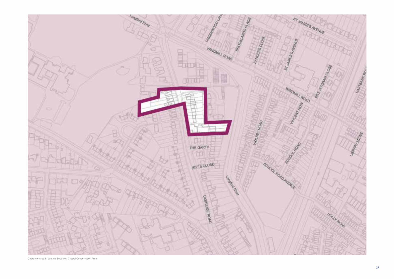
Character SummaryJoanna Southcott Chapel Conservation Area is situated within suburban Hampton Hill. It lies on the main Uxbridge Road and is contained to the west by Lady Eleanor Holles School grounds, to the north and east by the Longford River, and to the south by later suburban housing.
Joanna Southcott Chapel Conservation Area is a small cohesive historic group of modest unspoilt terraced and semi-detached cottages. They are set in garden plots with substantial, well planted and landscaped front gardens behind consistent boundary walls and fences to the street. All properties within the Conservation Area are recognised as ‘Buildings of Townscape Merit’.
The modest scale and character of this defined group of cottages, their mature gardens and trees, and the wider setting of open green spaces associated with Lady Eleanor Holles School, Fairlight and the Longford River and drains, provides an exceptional rural village like character to this area. The area has two distinctive elements to the east and west side of Uxbridge Road.
The cottages on the east side of the busy Uxbridge Road are attractive and simple in appearance with distinctly large front gardens.
The slightly later semi-detached houses on the west side of road have notably smaller front gardens but are slightly larger in scale and more formal in character including large bay windows projecting onto Uxbridge Road.
Key buildings include the exceptional former Chapel of Joanna Southcott (no.108) to the east of Uxbridge Road and in the north of the Conservation Area. The former public house (no.94)
in the south of the Conservation Area is also noteworthy and projects forward to the building line of the cottages at the centre, framing the buildings within the area.
Dominant Materials and Features Characteristic materials and features include: stock brick, traditional timber windows and shallow slate roofs.
Threats from Development ■ Loss of traditional architectural features and
materials due to unsympathetic alterations. ■ Loss of front boundary treatments and front
gardens for car parking. ■ Lack of coordination and poor quality of street
furniture and paving. ■ Domination of traffic and poor pedestrian safety
leading to clutter of signage and street furniture.
Opportunites
■ Preservation, enhancement and reinstatement of architectural quality and unity.
■ Retain and enhance front boundary treatments and discourage increase in the amount of hard surfacing in front gardens.
■ Coordination of colour and design and improvement in quality of street furniture and paving.
■ Improvement of highways conditions and pedestrian convenience, and rationalisation of existing signage and street furniture.
Conservation Area Statement: http://www.richmond.gov.uk/home/services/planning/conservation_areas/conservation_area_statements.htm
Character Area 6: Joanna Southcott Chapel Conservation Area
Former Public House, Uxbridge Road
Uxbridge RoadJoanna Southcott Chapel
This section provides a summary of the main characteristics of the Conservation Area. More detailed information can be viewed using the link provided below.
27
Character Area 6: Joanna Southcott Chapel Conservation Area

28
7. Features and Materials
The architectural features and palette of materials used in the construction and decoration of buildings are a large part of what makes up the character of an area. They vary depending on when and where a building was constructed. Even for buildings of the same period, subtle differences in construction materials can be what distinguish buildings in one part of the country from another, contributing to local distinctiveness.
Materials
The Hampton Hill area is made up of a wide variety of historic buildings that define the character of the area. Through the eighteenth, nineteenth and twentieth centuries, a palette of similar materials predominated in house building.
Using the correct materials (such as stock and red brick, clay tiles, slate and timber) is important for any repairs, alterations or extensions to existing buildings but also should be a consideration for any new development if it is to respect the context and character of the area. This is also important as traditional materials allow a building to ‘breathe’ (allow air to circulate and the materials to both absorb water when it rains and subsequently dry out).
Using modern, impervious materials can trap water and cause damp. Sourcing materials is very important, and it is always advisable to ask for samples that you can look at on site and compare with the palette of existing materials.In the context of historic buildings it is useful to look at the directory of specialist professionals on www.buildingconservation.com
Features
Victorian: The Victorian period (1837- 1901) saw an explosion of different styles and technological innovation. House building increased at a great rate to deal with the surge in population. The terraced house continued as the most popular and proliferate form of housing but mansion blocks of flats became increasingly common in London through the nineteenth century for all classes of people. Whilst Classicism retained a strong foothold through Queen Victoria’s reign and the simple, brick terraced house persisted, particularly as the most basic form of housing, the Gothic Revival is most commonly associated with this period and was popular as a way of enlivening houses.
Brick was still the basic load-bearing material for most buildings during this period though decorative coloured detailing became more popular. Renders and ornament (the latter usually made from artificial stone) also became more widespread. The Borough hosts a wide array of quality Victorian housing of all scales, styles and forms, from terraced mews to large detached villas.
Wolsey Road supports a number of fine examples of detached, semi-detached and short terraces all with a variety of details such as ornate barge boards and painted lintels. Similar examples can be found on Edwards Road. Holly Road, Park Place and Myrtle Road have consistent runs of terraces,
some with detailed render which defines the roads individual character.
Seymour Road has a run of well maintained picturesque semi-detached properties with distinctive white painted cornerstones and detailing all bound by distinctive white picket fencing.
Edwardian and Late Victorian: The Edwardian period was a high point in traditional construction and late-Victorian architecture is often indistinguishable from that of this period. The architecture of this period confidently mixes features from numerous styles. The work of Norman Shaw and the Arts and Crafts movement had a profound effect on house-design that was to dominate for decades to come with features of vernacular architecture becoming much more common.
St James’s Avenue includes a number of fine Edwardian buildings, with ornate painted render and timbered gables, a variety of original glass work with some buildings with turrets. Park Road also supports a number of grand Late Edwardian properties.
Late Victorian townhouses along Cranmer Road and Uxbridge Road are also from this period, set over three storeys these are gable ended properties with white painted features and stock brick.

29
Cast iron rainwater goodsProfiled parapet Dormer window with gable and bargeboard
Clay tiled roof
Tall brick chimneystack
Balcony with timber balustrade and brackets
Ornate glazing patternGate pier with coping
stonePeddledash render (right
hand house has been painted)
EDWARDIAN
Overhanging eaves Stock brick Slate roof
Classical mouldings in Stucco
Painted timber picket fence
Panelled door set in classical doorcase
VICTORIAN
Quoins
Keystone
String-course

30
Interwar housing: Interwar housing can be found across the Borough. The vernacular semi-detached houses that became popular pre-WWI became regularised into the standardised designs of the ‘Mock-Tudor semi’.
Fine examples of Mock-Tudor semis can be found on Park Road interspersed by Edwardian properties. Cranmer Road, St James’s Road and Burtons Road all have examples of 1930s semi-detached and detached properties from this period, some with oriel windows and a combination of brick and pebble dashed finishes.
Burtons Road and St James’s Road also include fine examples of Art Deco housing from later in this period, with curved bay windows and defining white painted lines, these are distinctive properties found across the Borough.
Post war (1960s and 1970s): A radical shift away from the traditional styles of the past century occurred with modernism and a new attitude to architecture and place-making. Blocks of flats were seen as the ideal solution to increasing density though the regular terraced house and low rise blocks of flats and maisonettes persisted.
Taylor Close represents a typical 1960/70s estate with its four storey blocks in a low density setting surrounded by green space
and parking, the blocks have simple detailing with white painted barge boards, red brick and hanging tiles. Other examples include The Garth on Uxbridge Road, which hosts properties typical of this period with interesting pointed and layered tiling.
Contemporary: There is a variety of more modern development across the area, including some infill and some more substantial estates. Recent development less rigorously conforms to a particular style or ethos. Higher density developments are more common as the pressure on land is greater.
There are a small number of contemporary developments found in pockets across the Village Plan area, including a stock brick run of terraces along Brooklands Place and Templeton Court on the High Street, a three or four storey block of flats with stock brick, cream rendering, Juliet balconies and a neutral string courses between floors.
7. Features and Materials (continued)

31
Red brick with tile courses
Red brick
Shallow pitched roof (tiled)Gable with patterned
brickwork, applied timbering and bargeboard
Panelled and glazed door
Clay tiled roof with ridge tiles
Hung tiles forming a pattern
WeatherboardingFlat roof
Integrated garage
Metal windows (horizontal proportions)
Integral garage
INTERWAR POSTWAR
Hung tiles

32
Windows
Windows are key features in all the buildings in Hampton Hill irrespective of the construction period. The location of the windows, their proportions, the number of glazing bars, the use of coloured glass, or the presence of old glass and the decorative treatment around the windows, all give each building its special character. The diversity of window types across the area add to its character and reinforce the distinctiveness of the different styles. Therefore, if houses or flats have original windows they should be restored or, if necessary, replaced like with like. Along with the promotion of character, sustainable materials should also be prioritised, through the use of environmentally friendly materials and also improving the energy efficiency of buildings.
Timber windows:
■ Historic timber windows are made from more durable timber than modern, softwood timber. Repairing them is therefore often a more durable as well as sustainable option.
■ Timber windows were always meant to be painted to protect them from the elements. Keeping them painted will help prevent them from rotting. If maintained, they can last indefinitely.
Window details:
■ Original leaded lights can add character to the street and be an important aspect of the design of the buildings. If the original windows have leaded lights they should be replicated if repairing them is not possible.
■ Stained glass should be retained or incorporated in replacement windows.
Double-glazing and thermal efficiency:
Improving the thermal efficiency of historic windows is a common reason for replacing them with double-glazing. If you are considering replacing your timber windows with uPVC bear in mind that the embodied energy lost by disposing of your windows and replacing them with uPVC, which have a limited life-expectancy, can be less sustainable than repairing them or installing secondary glazing. Traditional internal shutters are also a very effective means of improving thermal efficiency so if your property once had shutters, restoring them can be a sensible option.
There are a number of options to consider if the installation of double-glazing is pursued:
■ Have existing windows adapted by inserting an additional pane of glass within the existing frame to improve sound and thermal insulation. This is only really possible with unlisted buildings with deep window profiles.
■ Timber double-glazing is now a good option with improving technology that can achieve very slim window profiles that compare with Victorian and Edwardian single-glazing.
■ Thin profile double glazed acoustic glass is available that can be fitted into existing timber frames. This can be a way of upgrading the sound and insulation performance of windows without the need for total replacement.
■ Install secondary glazing which is very effective in improving thermal and sound insulation. They can often be removed in the summer months when less needed.
uPVC is often considered as it is seen as a cheaper option than most timber double-glazed units. However, it is not authentic and cannot achieve the same detailed mouldings or appearance and is therefore discouraged. If you feel that this is your only option you should bear in mind:
■ the materials, design, proportions and the means of opening (sash/casement) of the existing windows and try to faithfully replicate them.
■ the proportions of the glazing bars should replicate those on the original windows.
■ glazing bars should be integral to the structure of the window and not applied to the outside of the glass and should be raised rather than flat.
■ top-hung casements are not a good substitute for sliding sashes.
Historic England provide guidance on sensitive alterations to enhance environmental performance in historic buildings: https://historicengland.org.uk/advice/technical-advice/energy-efficiency-and-historic-buildings/
7. Features and Materials (continued)

33
Curved sash windows with stock brick keystone
Timber casement window in a Victorian house
Art deco style curved metal framed window
Timber front enterance door with oval stained glass glazing. Porch surround includes significant black and white painted timber consoles
Dutch gabled frontage with stock brick, white painted keystones above six over six sash windows
Half colonial sash window with original render detailing either side
Panelled timber front door with white painted classical door frame
Painted door with glazing set in a significant porch with hanging tiles, ornate timber barge boards
Painted render and timber frontage and timber casement windows

34
Late Victorian / Edwardian InterwarVictorian
7. Features and Materials (continued)

35
Post War Contemporary

36
8. Development Guidance
St Clare Business Park, Holly Road
The Local Plan identifies this site as Locally Important Industrial Land and Business Park (Policy LP42). While there is no specific proposal for its redevelopment in the Local Plan, its poor condition was identified during the consultation on the SPD.

37
St Clare Business Park

38
9. Shop Front Guidance
The Council has an adopted general guide to shopfront design (Shopfronts Supplementary Planning Document (SPD), March 2010). The guidance provided here does not replace that SPD but provides area-specific information on shopfronts in Hampton Hill, highlighting positive features in particular shopfronts. This is a means of identifying shopfronts worth preserving and provides a context for enhancing other shopfronts.
The Shopfronts SPD sets out the policy context for when planning permission and listed building consent is needed for new shopfronts and gives Borough wide guidance. Planning permission is invariably needed for replacement shopfronts, and advertisement consent may be needed for new signage. This Village Planning Guidance SPD should be read in conjunction with the 2010 SPD.
Hampton Hill has individual historic shopfronts as well as unified shopping parades. These should be preserved and, where architectural details are missing, they should ideally be replaced. As a general rule, shopfronts and alterations proposed to them should respect the character, overall design and materials of the host building.
Shopping parades were often built with the same shopfronts along their length. Over time many get replaced and the uniformity of the parades is undermined. Sometimes the replacement shopfronts have value for the quality of their design, craftsmanship or historic value and should be retained. Often
however, the replacement shopfronts lack aesthetic value and are installed without consideration for how they will affect the appearance of the whole parade and street.
When considering alterations to a shopfront or its replacement, consideration should be given to:
■ the appearance of the host building as a whole and the designs of the adjacent shopfronts;
■ uniformity: where a parade historically had identical shopfronts, reinstating the same appropriate design and materials, where the replacements are poor quality, can help create a more attractive street; and
■ if there are a couple of identical surviving historic shopfronts in a parade these may well be the original historic design, replicating them in place of low-quality modern shopfronts should be explored.
Within a building or parade there are often two or more good different examples of shopfronts which should be retained and sometimes the subtle differences in detail will enhance the character of the area. However, the basic structure and features of traditional shopfronts (as identified in the Shopfront SPD) are usually present and should be adhered to and enhanced where possible.
Shutters
External metal security shutters are not a traditional feature of shopfronts and generally detract from their character. Roller shutters, when lowered, can create an unattractive environment. If considered necessary, metal lattice-type shutters on the inside of the shop window can provide security without spoiling the external appearance of the shop front. The other traditional alternatives are external canvas awnings or timber shutters.

39
Slender timber glazing bars Leaded upper lights with stained glass
Typical key features to shop fronts
Timber glazing bars divided into smaller upper lights
Recessed entrance with stone threshold
Panelled stallriser and pilasters
Retractable canvas awning with timber end-board
Historic fascia board with distinctive intact white-on-
black letteringDentil cornice
Console bracketsConsole bracketsRetractable canvas awning
with timber end-board
Recessed entrance with chequerboard tiled pavement

40
9. Shop Front Guidance (continued)
High Street, Hampton Hill
The High Street in Hampton Hill has an unusually long sequence of shops, extending approximately from the bridge over Bushy Park’s Longford River, northward up to the junction with Hampton Road. It is characterised just as much by the individual, one-off shops as by the longer parades, which are relatively few in number and vary in style. This variety, coupled with the modest height of the buildings (often two storeys) helps to create an informal village-like character.
The nineteenth century parade at Nos. 35-41 (odd) is a simple two storey building of brick, with console brackets between each shop. It includes a corner shop at No. 41 that is exceptionally well preserved, complete with fascia board retaining distinctive lettering of c. 1900.
Nos. 58-64 (even) High Street, Hampton Hill is a relatively well-preserved Neo-Georgian parade, c. 1930s. The shops are divided by distinctive scrolled console brackets and the shopfronts at Nos. 58 and 64 retain traditional features.
The parade at Nos. 109-141 (odd) High Street, Hampton Hill dates from the Edwardian period but is marred by crude modern shopfronts with oversized detracting fascia boards. The shops are still divided by the original, distinctive piers which are clad in two shades of green faience.
There is a modern, 1950s parade at 169-177 (odd) High Street, Hampton Hill, the upper storeys clad with hung tiles. As a group the shopfronts now lack any coherence. The original treatment may perhaps be indicated by No. 173, which has chrome edging and a distinctive disk-like door handle.
The terrace at Nos. 185-195 (odd) High Street, Hampton Hill does not have the traditional dividing piers and brackets between the shops, so may not have been built as a parade. It resembles a domestic terrace, c. 1860s. The shopfronts are now entirely modern, with large fascia boards that detract from the character.
Around the corner at Nos. 1-6 New Broadway (on Hampton Road) is a simple 1920s parade with detracting uPVC windows to the upper floors but there are two matching, very well-preserved shopfronts at Nos. 3 and 4, each with a sunburst glazing pattern.
169-177 High Street3-4 New Broadway
35-42 HIgh Street

41
Key examples
No. 12 High Street, Hampton Hill
The unit, currently occupied by a Bakery, is in good condition which stands out on this part of the High Street between intermittent shop frontages and residential properties. The frontage itself supports a number ofpositive features including recessed entrance with chequerboard tiled pavement, console brackets, slender timber glazing bars, leaded upper lights with stained glass, retractable canvas awning with timber end-board.
No. 34 High Street, Hampton Hill
The black painted shop frontage has a recessed entrance, slender glazing bars designed as colonettes (i.e. with bases and capitals), ventilation grilles, tiled stallriser (NB. paint detracts).
No. 41 High Street, Hampton Hill
The unit occupies the corner of Holly Road with its recessed entrance with stone threshold and an array of original features including panelled stallriser and pilasters, console brackets, timber glazing bars divided into zones with smaller upper lights, historic fascia board with distinctive intact white-on-black lettering, dentil cornice and retractable canvas awning with timber end-board.
Nos. 3-4 New Broadway, Hampton Road, Hampton Hill
Located on the 1920s parade to the East of the charater area, these frontages boast recessed entrances with chequerboard tiled pavements, stallriser, slender chrome glazing bars, upper lights with frosted glass in sunburst design and retractable canvas awning with timber end-board.

42
10. Forecourt Parking
The Council has an existing Supplementary Planning Document (SPD) covering ‘Front Garden and Other Off Street Parking Standards’ (adopted September 2006). This document provides detailed advice on the legal and design issues when creating a parking area in your front garden and access to it from the highway. Council Local Plan Policy LP45 also establishes the principle approach to Forecourt Parking, notably that it will be discouraged. Highway Authority permission for construction of a crossover is required in all cases, and the SPD standard will be applied to all highway crossover applications.
The Hampton Hill Village Planning Guidance SPD draws upon the 2006 SPD, providing updated and specific information for Hampton Hill. It is important that the 2006 SPD is read in conjunction with the guidance below. It is also advised to refer to the Council’s Supplementary Planning Document on ‘Design Quality’ and ‘Public Space Design Guide’.
In Hampton Hill as in other areas of Richmond and across London as a whole, increases in population and car ownership have resulted in greater demand for car parking spaces. Where houses are not able to have garages, or where there is insufficient on and off street parking, this can lead to increased demand for front garden parking. Conversion of front gardens for car parking can individually and cumulatively
adversely impact on the appearance of an area and detract from its overall character if undertaken without careful consideration.
The Council is keen that where front garden parking does occur, it is done in the best possible way, by following guidance given in this and the 2006 SPD.
Planning Permission
In some cases alterations to front gardens fall within the terms of ‘permitted development’, in which case planning approval is not required and therefore the Council has little or no control over the creation of forecourt parking. You will not normally need planning permission, outside of a Conservation Area if a new or replacement driveway of any size uses permeable (or porous) surfacing which allows water to drain through, such as permeable concrete block paving or porous asphalt, or by directing rainfall to a lawn or border to drain naturally.
If the surface to be covered is more than five square metres planning permission will be needed for laying traditional, impermeable driveways. It is important to note that in Conservation Areas, planning permission is required for demolition of boundary walls, fences and railings over 1m in height.
Article 4(2) Directions can also restrict the removal of structures such as those that would be required to allow access for parking (see the 2006 SPD for details).
The Council’s Local Plan (Policy LP45)generally discourages front garden parking because of the impact on the appearance of the street and loss of vegetation and biodiversity. When forecourt parking is proposed, this SPD seeks to ensure it is provided in a sympathetic way.
It is generally considered that additional forecourt parking does not significantly reduce parking congestion as it results in the loss of on-street parking.
Important features in Hampton Hill
Many front gardens and frontage features in Hampton Hill contribute significantly to the overall character of the area and local street scene both within and outside of the Conservation Areas. These include brick gate piers, dwarf walls incorporating railings or hedges, planted front gardens and a very high number of street trees.
Boundary Walls
Boundary walls are perhaps the most important and defining feature of a street scene, and their preservation and uniformity adds considerably to an area’s character. They enclose front gardens and define public and private space. Low walls create this space without reducing visibility. Conforming traditional brick types and brickwork along a street is an important characteristic.
Boundary walls to Victorian and Edwardian housing often consist of low brick walls
punctuated by taller piers in the same brick, topped by coping stones. The larger houses would often have bespoke, more ornate versions, as seen in the notable surviving examples on Park Road and St James’s Avenue.
The interwar period, especially, produced a streetscape with a distinctive character. The boundary walls to the many detached and semi-detached houses from this period often had a stepped or undulating profile, sometimes rendered but more often in brick. Again, the larger houses would have the more ornate examples, as seen on St James’s Road, Hampton Hill. But, the simpler examples, e.g. as seen in Longford Close, Hampton Hill are just as distinctive.
However, a large number of boundary walls have either been replaced with a different design or with no wall at all. There is an opportunity to reinforce local distinctiveness by installing boundary walls that are based on intact examples nearby, particularly along parts of Windmill Road and Cranmer Road which impact the rhythm of the streets and frontages.
Fencing
Picket fencing is a feature found across the Hampton Hill area. It is common that modest examples of Victorian housing found in the Borough i.e. the simple brick two storey cottages and terraces, are often given a timber picket fence. These are just

43
as distinctive and can add positively to local character, though require regular maintenance.
The majority of properties in the tight-knit Victorian Terraces along Park Place and Myrtle Road have retained their original picket fencing, within few replaced by boundary walls or removed entirely.
Seymour Road’s run of early Victorian terraces with distinctive white painted cornerstones have all maintained their original white picket fencing, which emphasises the quality and consistency of the properties.
Iron railings and gates
Iron railings (and gates) feature on some houses in Hampton Hill but are generally a less common feature. Where they are present, traditional railings are typically embedded into a lower boundary wall, enclosing the front garden whilst keeping visual obstruction to a minimum. Examples of this can be found on Albert Road and Wolsey Road.
Hedges
Hedges enclose front gardens and define public and private space. They provide an attractive green feature to the streetscape. Therefore it is important for them to be retained as frontage features, either on their own or in combination with walls or railings.
Park Road has a number of fine houses fronted with hedges, used to buffer noise and the general disturbance of the road. Burtons Road, bound to the north by a significant hedge, bounded by many of the front gardens, with a variety of individual hedges and hedging above dwarf walls.
Retention of existing features
The general aim of any design for car parking in front gardens should be to retain as much of the existing features as is practical – such as existing walls, railings or hedging. Where an opening has to be made in an existing wall, railing or fence, it should be made good at both ends to match existing materials and details, and should be no more than a car width wide.
Enclosure
Retaining a form of enclosure to front gardens and forecourts is an essential part of retaining local character and maintaining the street scene. Partial loss of existing structures is inevitable to allow vehicle access but some structure should be retained. Inward opening gates help to complete a defensible line. For the above reasons the gap in the boundary should not exceed that needed for the passage of a car. This also reduces the loss of parking space in the road outside.
Permeability
The base and finished surface should be laid at a slight gradient and be of a permeable material, to allow the satisfactory drainage and absorption of rainwater. Water should not drain from the property onto the footway. A length of drain or soak-away may be required at the site boundary to prevent this or a connection to a surface water sewer can be established with the agreement of the Water Authority. Loose gravel should be avoided.
Green features
Loss of existing green space may be inevitable, however retaining and / or replacing some planting in a generous manner may help to maintain the area’s character, screen vehicles and create a more pleasant natural environment by absorbing local exhaust fumes.
St James’s Avenue, Hedges
St James’s Road, Boundary Wall
Seymour Road, Fencing

44
LBRuT Publication Local Plan (January 2017)
Main policies that the SPD will support:
Policy LP 1: Local Character and Design Quality
The Council will require all development to be of high architectural and urban design quality. The high quality character and heritage of the borough and its villages will need to be maintained and enhanced where opportunities arise. Development proposals will have to demonstrate a thorough understanding of the site and how it relates to its existing context, including character and appearance, and take opportunities to improve the quality and character of buildings, spaces and t he local area.
To ensure development respects, contributes to and enhances the local environment and character, the following will be considered when assessing proposals:
1. Compatibility with local character including the relationship to existing townscape, development patterns, views, local grain and frontages as well as scale, height, massing, density, landscaping, proportions, form, materials and detailing;
2. Sustainable design and construction, including adaptability, subject to aesthetic considerations;
3. Layout, siting and access, including making
best use of land;
4. Space between buildings, relationship of heights to widths and relationship to the public realm, heritage assets and natural features;
5. Inclusive design, connectivity, permeability (as such gated developments will not be permitted), natural surveillance and orientation; and
6. Suitability and compatibility of uses, taking account of any potential adverse impacts of the co-location of uses through the layout, design and management of the site.
All proposals, including extensions, alterations and shop fronts, will be assessed against the advice set out in the relevant Village Planning Guidance and other SPDs relating to character and design.
Shop fronts
The Council will resist the removal of shopfronts of architectural or historic interest. Shopfronts, including signage and illumination, should complement the proportions, character, materials and detailing, surrounding streetscene and the building of which it forms part. Blinds, canopies or shutters, where acceptable in principle, must be appropriate to the character of the shopfront and its context within which it is located. External security grilles and large illuminated fascias will only be allowed in exceptional circumstances. In
sensitive areas, rigid and gloss finish blinds will generally be unacceptable.
Advertisements and hoardings
The Council will exercise strict control over the design and siting of advertisements and hoardings to ensure the character of individual buildings and streets are not materially harmed, having regard to the interests of amenity and public safety (including highway safety).
Within the existing Core Strategy (2009) the equivalent policy is Policy CP7 and in the Development Management Plan (2011) the equivalent policies are Policy DC1 and Policy DC7.
Policy LP 25: Development in Centres
A. Development in the Borough’s centres, as defined in the centre hierarchy, will be acceptable if it:
1. Is in keeping with the centre’s role and function within the hierarchy and is of a scale appropriate to the size of the centre (also see the Spatial Strategy of this Plan); and
2. Is in an appropriate location, as follows:
a. A1 uses should be located within, adjacent to or well-related (or capable of being made so) to designated shopping frontages.
b. For other appropriate uses (see B below), major development and/or developments which generate high levels of trips should
be located within a Main Centre Boundary. Elsewhere development should be located within the defined Area of Mixed Use (AMU boundary). For centres, or parts of centres where no boundary exists, proposals should be well-related to designated shopping frontages.
Proposals not in the above locations, including extensions to existing retail and leisure developments of more than 200sqm gross, should satisfy the Sequential Test as set out in national policy and guidance. Out of centre retail development is not considered appropriate in line with the London Plan; and
3. Does not adversely impact on the vitality and viability of the centre in which the development is proposed, or another centre. When assessing proposals for development outside of existing centres, applicants will have to comply with the requirements of national policy and guidance in relation to impact assessments. For retail developments, including extensions of over 500sqm gross, the Council will require a Retail Impact Assessment.
The scope of such assessments will need to be agreed with the Council before submitting a planning application; and
4. Optimises the potential of sites by contributing towards a suitable mix of uses that enhance the vitality and viability of the centre. Commercial or community uses should be provided on the ground floor
Appendix 1: Relevant Policies and GuidanceIt should be noted that all adopted policies and guidance should be assessed for their relevance in respect of individual planning applications, not just those listed below.

45
fronting the street, subject to other Local Plan policies, including the retail frontages policy LP 26.
B. In addition to A above, the following applies to development proposals in the borough’s five main centres:
1. The Council will support appropriate development in the five main centres.
2. The Council will encourage proposals for leisure, cultural and tourism facilities which contribute to the diversity of the offer.
3. Proposals for A1 uses should include, where appropriate, units of a size suitable for modern retail needs (particularly in Richmond centre, where there is a shortage of retail units with larger floor-plates) whilst retaining sufficient traditional smaller units that add to the local character and which are important to local businesses.
C. In addition to A above, in the local and neighbourhood centres as well as parades of local importance, the following applies:
1. Appropriate uses could include new retail (including markets), business or employment developments, which maintain suitable provision for small businesses, and other uses, which primarily serve the needs of the local community or attract visitors and develop cultural opportunities.
2. Development should, wherever possible, include overall improvements and enhancements of the small centres where
appropriate, and/or modernise outdated premises.
Within the existing Core Strategy (2009) the equivalent policy is Policy CP7 and in the Development Management Plan (2011) the equivalent policies are Policy DC1, Policy DC7, Policy DM TC 2.
Policy LP35: Housing Mix and Standards
A. Development should generally provide family sized accommodation, except within the five main centres and Areas of Mixed Use where a higher proportion of small units would be appropriate. The housing mix should be appropriate to the location.
B. All new housing development, including conversions, are required to comply with the Nationally Described Space Standard.
C. All new housing development, including conversions, are required to comply with the Council’s external space standards. For houses a minimum total private space of 70sqm for 3 or more beds and 40sqm for 2 beds should be provided. To provide adequate private amenity space for flats, a minimum of 5sqm of private outdoor space for 1-2 person dwellings should be provided and an extra 1sqm should be provided for each additional occupant. Purpose built, well designed and positioned balconies or terraces are encouraged where new residential units are on upper floors, if they comply with policy LP8 Amenity and Living
Conditions.
D. Amenity space for all new dwellings, including conversions, should be:
a. private, usable, functional and safe;
b. easily accessible from living areas;
c. orientated to take account of need for sunlight and shading;
d. of a sufficient size to meet the needs of the likely number of occupiers; and
e. accommodation likely to be occupied by families with young children should have direct and easy access to adequate private amenity space.
E. 90% of all new build housing is required to meet Building Regulation Requirement M4 (2) ‘accessible and adaptable dwellings’ and 10% of all new build housing is required to meet Building Regulation Requirement M4 (3) ‘wheelchair user dwellings’.
Within the existing Core Strategy (2009) the equivalent policy is Policy CP14.
Policy LP43: Visitor Economy
A. The Council will support the sustainable growth of the visitor economy for the benefit of the local area by:
1. Supporting proposals which promote and enhance the Borough’s existing tourist attractions, including the unique, historic and cultural assets that are connected via the River Thames, such as The Royal Botanic
Gardens, Kew, Ham House and Hampton Court Palace;
2. Proposals that lead to increased visitors and tourists need to be of an appropriate scale for the size of the centre and will be assessed against the transport policies of this Plan;
3. Requiring accommodation and facilities to be accessible to all; at least 10% of hotel bedrooms should be wheelchair accessible;
4. Enhancing the environment in areas leading to, within and around visitor destinations where appropriate.
B. In relation to visitor accommodation:
1. Proposals which result in the loss of bedspaces will be resisted;
2. Proposals which increase the number of bedspaces will be supported subject to other Local Plan policies;
3. Proposals will be supported which contribute towards providing a range of visitor accommodation, including small independent hotels and bed and breakfast accommodation, subject to other Local Plan policies.
Within the existing Core Strategy (2009) the equivalent policy is Policy CP20.
LP12: Green Infrastructure
Green infrastructure is a network of multi-functional green spaces and natural elements, which provides multiple benefits

46
for people, nature and the economy.
A. To ensure all development proposals protect, and where opportunities arise enhance, green infrastructure, the following will be taken into account when assessing development proposals:
a. The need to protect the integrity of the green spaces and assets that are part of the wider green infrastructure network; improvements and enhancements to the green infrastructure network are supported;
b. Its contribution to the wider green infrastructure network by delivering landscape enhancement, restoration or re-creation; and
c. Incorporating green infrastructure assets, which make positive contributions to the wider green infrastructure network.
Within the existing Core Strategy (2009) the equivalent policy is Policy C10.
LP13: Green Belt, Metropolitan Open Land and Local Green Space
Green Belt and Metropolitan Open Land
A. The Borough’s Green Belt and Metropolitan Open Land will be protected and retained in predominately open use. Inappropriate development will be refused unless ‘very special circumstances’ can be demonstrated that clearly outweigh the harm to the Green Belt or Metropolitan Open Land.
Appropriate uses within Green Belt or Metropolitan Open Land include public and private open spaces and playing fields, open recreation and sport, biodiversity including rivers and bodies of water and open community uses including allotments and cemeteries. Development will be supported if it is appropriate and helps secure the objectives of improving the Green Belt or Metropolitan Open Land.
B. It will be recognised that there may be exceptional cases where inappropriate development such as small scale structures may be acceptable, but only if it:
1. Does not harm the character and openness of the Green Belt or Metropolitan Open Land; and
2. Is linked to the functional use of the Green Belt or Metropolitan Open Land, or supports outdoor open space uses; or
3. Is for essential utility infrastructure and facilities for which it needs to be demonstrated that no alternative locations are available and that they do not have any adverse impacts on the character and openness of the Green Belt or Metropolitan Open Land.
C. Improvement and enhancement of the openness and character of the Green Belt or Metropolitan Open Land and measures to reduce visual impacts will be encouraged where appropriate.
When considering developments on sites
outside Green Belt or Metropolitan Open Land, any possible visual impacts on the character and openness of the Green Belt or Metropolitan Open Land will be taken into account.
Local Green Space
D. Local Green Space, which has been demonstrated to be special to a local community and which holds a particular local significance, will be protected from inappropriate development that could cause harm to its qualities.
Within the existing Core Strategy (2009) the equivalent policy is Policy CP10.
Policy LP14: Other Open Land of Townscape Importance
Other open areas that are of townscape importance will be protected in open use, and enhanced where possible. It will be recognised that there may be exceptional cases where appropriate development is acceptable. The following criteria will be taken into account when assessing whether development is appropriate:
a. It must be linked to the functional use of the Other Open Land of Townscape Importance;
or
b. It can only be a replacement of, or minor extension to, existing built facilities; and
c. It does not harm the character or
openness of the open land.
Improvement and enhancement of the openness or character of other open land and measures to open up views into and out of designated other open land will be encouraged.
When considering developments on sites outside designated other open land, any possible visual impacts on the character and openness of the designated other open land will be taken into account.
Within the existing Core Strategy (2009) the equivalent policy is Policy CP10 and in the Development Management Plan (2011) the equivalent policy is OS3.
Policy LP30: Health and Wellbeing
Planning, at all levels, can play a crucial role in creating environments that enhance people’s health and wellbeing. The Council promotes and supports healthy and active lifestyles and measures to reduce health inequalities.
A. The Council will support development that results in a pattern of land uses and facilities that encourage:
1. Sustainable modes of travel such as safe cycling routes, attractive walking routes and easy access to public transport to reduce car dependency.
2. Access to green infrastructure, including river corridors, local open spaces as well as leisure, recreation and play facilities to encourage physical activity.

47
3. Access to local community facilities, services and shops which encourage opportunities for social interaction and active living, as well as contributing to dementia-friendly environments.
4. Access to local healthy food, for example, allotments and food growing spaces.
5. Access to toilet facilities which are open to all in major developments where appropriate (linked to the Council’s Community Toilet Scheme).
6. An inclusive development layout and public realm that considers the needs of all, including the older population and disabled people.
B. This policy will be delivered by requiring developments to comply with the following:
1. A Health Impact Assessment must be submitted with all major development proposals.
2. The Council will refuse proposals for new fast food takeaways (A5 uses) located within 400 metres of the boundaries of a primary or secondary school in order to restrict the availability of unhealthy foods.
3. Existing health facilities will need to be retained where these continue to meet, or can be adapted to meet residents’ needs.
4. Applications for new or improved facilities or loss of health and social care facilities will be assessed in line with
the criteria set out in the Social and Community Infrastructure policy.
Within the existing Core Strategy (2009) the equivalent policy is Policy CP17.
Policy LP26: Retail Frontages
The Council has designated parts of centres as Key Shopping Frontage or Secondary Shopping Frontage.
Key Shopping Frontages
A. Proposals that result in a loss of floorspace in Use Class A1 in Key Shopping Frontages will be resisted. Other uses converting to retail will be supported, subject to there being no adverse impact on the centre. The Council will seek to retain key facilities including Post Offices.
Secondary Shopping Frontages
B. A non-A1 proposal will be acceptable in the secondary shopping frontages only if it:
1. (a) Meets community needs (such as a dentist, clinic or health centre, veterinary surgery, gym, fitness studio and facilities which would enable the public better access to police services) and provides a direct service to visiting members of the public, or
(b) Falls within Use Classes A2 to A5, or
(c) Is another commercial use which provides a direct service to visiting members of the public without appointment.
In addition to (a) or (b) above, the proposal must the meet the following criteria:
2. the proposed use should retain a ‘shop-like’ appearance; it should not have a detrimental visual impact on the shopfront and should respect the heritage and character of the centre, taking into account the Village Planning Guidance SPDs;
3. the proposed use has to be complementary to the area’s shopping function and provide a direct service to the public; and
4. it will not create an unbroken run of three or more non-A1 units.
Within the existing Development Management Plan (2011) the equvielent policy is Policy DM TC 3.
Policy LP3: Designated Heritage Assets
A. The Council will require development to conserve and, where possible, take opportunities to make a positive contribution to, the historic environment of the borough. The significance (including the settings) of the borough’s designated heritage assets, encompassing Conservation Areas, Listed Buildings, Scheduled Monuments as well as the Registered Historic Parks and Gardens, will be conserved and enhanced by the following means:
1. Give great weight to the conservation of the heritage asset when considering the impact of a proposed development on the significance of the asset.
2. Resist the demolition in whole, or in part, of Listed Buildings. Consent for demolition of Grade II Listed Buildings will only be granted in exceptional circumstances and for Grade II* and Grade I Listed Buildings in wholly exceptional circumstances following a thorough assessment of their significance.
3. Resist the change of use of Listed Buildings where this would materially harm their character and distinctiveness, particularly where the current use contributes to the character of the surrounding area and to its sense of place.
4. Require the retention and preservation of the original structure, layout, architectural features, materials as well as later features of interest within Listed Buildings, and resist the removal or modification of features that are both internally and externally of architectural importance or that contribute to the significance of the asset.
5. Demolitions (in whole or in part), alterations, extensions and any other modifications to Listed Buildings should be based on an accurate understanding of the significance of the heritage asset.
6. Require, where appropriate, the reinstatement of internal and external

48
features of special architectural or historic significance within Listed Buildings, and the removal of internal and external features that harm the significance of the asset, commensurate with the extent of proposed development.
7. Require the use of appropriate materials and techniques and strongly encourage any works or repairs to a designated heritage asset to be carried out in a correct, scholarly manner by appropriate specialists.
B. Resist substantial demolition in Conservation Areas and any changes that could harm heritage assets, unless it can be demonstrated that:
1. in the case of substantial harm or loss to the significance of the heritage asset, it is necessary to achieve substantial public benefits that outweigh that harm or loss;
2. in the case of less than substantial harm to the significance of the heritage asset, that the public benefits, including securing the optimum viable use, outweigh that harm; or
3. the building or part of the building or structure makes no positive contribution to the character
or distinctiveness of the area.
C. All proposals in Conservation Areas are required to preserve and, where possible, enhance the character or the appearance of the Conservation Area.
D. Where there is evidence of intentional
damage or deliberate neglect to a designated heritage asset, its current condition will not be taken into account in the decision-making process.
E. Outline planning applications will not be accepted in Conservation Areas. The Council’s Conservation Area Statements, and where available Conservation Area Studies, and/or Management Plans, will be used as a basis for assessing development proposals within, or where it would affect the setting of, Conservation Areas, together with other policy guidance, such as Village Planning Guidance SPDs.
Within the existing Development Management Plan (2011) the equivalent policies are Policy DM OS 4, Policy DM HD 1 and Policy DM HD 2.
Policy LP 4: Non-Designated Heritage Assets
The Council will seek to preserve, and where possible enhance, the significance, character and setting of non-designated heritage assets, including Buildings of Townscape Merit, memorials, particularly war memorials, and other local historic features.
There will be a presumption against the demolition of Buildings of Townscape Merit.Applicants will be required to:
1. Retain the character of Buildings of Townscape Merit, war memorials and any other non-designated heritage assets;
2. Submit a Heritage Statement to assess
the potential harm to, or loss of, the significance of the non-designated heritage asset, including from both direct and indirect effects;
3. Describe the significance of the non-designated heritage asset affected, including any contribution made by their setting; the extent of the relevant setting will be proportionate to the significance of the asset. Appropriate expertise should be used to assess a non-designated heritage asset; and
4. Retain or restore the structures, features and materials of the asset, which contribute to its architectural integrity and historic interest.
Within the existing Development Management Plan (2011) the equivalent policy is Policy DM HD 3.
Policy LP5: Views and Vistas
The Council will protect the quality of the views, vistas, gaps and the skyline, all of which contribute significantly to the character, distinctiveness and quality of the local and wider area, by the following means:
1. Protect the quality of the views and vistas as identified on the Proposals Map, and demonstrate such through computer-generated imagery (CGI) and visual impact assessments;
2. Resist development which interrupts, disrupts or detracts from strategic and local
vistas, views, gaps and the skyline;
3. Require developments whose visual impacts extend beyond that of the immediate street to demonstrate how views are protected or enhanced;
4. Require development to respect the setting of a landmark, taking care not to create intrusive elements in its foreground, middle ground or background;
5. Improvements to views, vistas, gaps and the skyline, particularly where views or vistas have been obscured, will be encouraged where appropriate;
6. Seek improvements to views within Conservation Areas, which:
a. Are identified in Conservation Area Statements and Studies and Village Plans;
b. Are within, into, and out of Conservation Areas;
c. Affect the setting of and from development on sites adjacent to Conservation Areas and Listed Buildings.
Within the existing Development Management Plan (2011) the equivalent policy is Policy DM TC 7.
Policy LP38: Loss of Housing
A. Existing housing should be retained.
B. Proposals for reversions and conversions should assess the suitability of the property and design considerations.

49
C. Redevelopment of existing housing should normally only take place where:
a. It has first been demonstrated that the existing housing is incapable of improvement or conversion to a satisfactory standard to provide an equivalent scheme; and, if this is the case
b. The proposal does not have an adverse impact on local character; and
c. The proposal provides a reasonable standard of accommodation.
Within the existing Development Management Plan (2011) the equivalent policy is Policy DM HO 1.
Policy LP39: Infill, Backland and Backgarden Development
Infill and Backland Development
A. All infill and backland development must reflect the character of the surrounding area and protect the amenity and living conditions of neighbours. In considering applications for infill and backland development the following factors should be addressed:
1. Retain plots of sufficient width for adequate separation between dwellings;
2. Retain similar spacing between new buildings to any established spacing;
3. Retain appropriate garden space for adjacent dwellings;
4. Respect the local context, in accordance with policy LP 2 Building Heights;
5. Enhance the street frontage (where applicable) taking account of local character;
6. Incorporate or reflect materials and detailing on existing dwellings, in accordance with policy LP 1 Local Character and Design Quality;
7. Retain or re-provide features important to character, appearance or wildlife, in accordance with policy LP 16 Trees and Landscape;
8. Result in no unacceptable adverse impact on neighbours, including loss of privacy to existing homes or gardens, in accordance with policy LP 8 Amenity and Living Conditions;
9. Provide adequate servicing, recycling and refuse storage as well as cycle parking;
10. Result in no adverse impact on neighbours in terms of visual impact, noise or light from vehicular access or car parking.
Back Garden Development
B. There is a presumption against loss of back gardens due to the need to maintain local character, amenity space and biodiversity. Back garden land which contributes either individually or as part of a larger swathe of green space to amenity of residents or provides wildlife
habitats must be retained. In exceptional cases where it is considered that a limited scale of back garden development may be acceptable it should not have a significantly adverse impact upon the factors set out above. Development on back garden sites must be more intimate in scale and lower than frontage properties.
Within the existing Development Management Plan (2011) the equivalent policies are Policy DM HO 2 and Policy DM HO 3.
Policy LP45: Parking Standards and Servicing
Parking standards
The Council will require new development to make provision for the accommodation of vehicles in order to provide for the needs of the development while minimising the impact of car based travel including on the operation of the road network and local environment, and ensuring making the best use of land. It will achieve this by:
1. Requiring new development to provide for car, cycle, 2 wheel and, where applicable, lorry parking and electric vehicle charging points, in accordance with the standards set out in Appendix 3. Opportunities to minimise car parking through its shared use will be encouraged.
2. Resisting the provision of front garden car parking unless it can be demonstrated that:
a. There would be no material impact on road or pedestrian safety;
b. There would be no harmful impact on the character of the area, including the streetscape or setting of the property, in line with the policies on Local Character and Design; and
c. The existing on street demand is less than available capacity.
3. Car free housing developments may be appropriate in locations with high public transport accessibility, such as areas with a PTAL of 5 or 6, subject to:
a. The provision of disabled parking;
b. Appropriate servicing arrangements; and
c. Demonstrating that proper controls can be put in place to ensure that the proposal will not contribute to on-street parking stress in the locality.
All proposals for car free housing will need to be supported by the submission of a Travel Plan.
4. Managing the level of publicly available car parking to support the vitality and viability of town and local centres within the borough whilst limiting its impacts on the road network.
Freight and Servicing
New major development which involves freight movements and has servicing needs

50
will be required to demonstrate through the submission of a Delivery and Servicing Plan and Construction and Logistics Plan that it creates no severe impacts on the efficient and safe operation of the road network and no material harm to the living conditions of nearby residents.
Within the existing Development Management Plan (2011) the equivalent policies are Policy DM TP 8 and Policy DM TP 9.
Policy LP 16: Trees and Landscape
The Council will require the protection of existing trees and the provision of new trees, shrubs and other vegetation of landscape significance that compliment existing, or create new, high quality green areas, which deliver amenity and biodiversity benefits.
To ensure development protects, respects, contributes to and enhances trees and landscaping, the Council, when assessing development proposals, will:
Trees
1. Resist the loss of trees unless the tree is dead, dying or dangerous; or the tree is causing significant damage to adjacent structures; or the tree has little or no amenity value; or felling is for reasons of good arboricultural practice;
2. Resist development which results in the
damage or loss of trees that are considered to be of townscape or amenity value; the Council will require that site design or layout ensures a harmonious relationship between trees and their surroundings and will resist development which will be likely to result in pressure to significantly prune or remove trees;
3. Require, where practicable, an appropriate replacement for any tree that is felled; a financial contribution to the provision for an off-site tree in line with the monetary value of the existing tree to be felled will be required in line with the ‘Capital Asset Value for Amenity Trees’ (CAVAT);
4. Require new trees to be of a suitable species for the location in terms of height and root spread; the use of native species is encouraged where appropriate;
5. Require that trees are adequately protected throughout the course of development, in accordance with British Standard 5837 (Trees in relation to design, demolition and construction – Recommendations).
The Council may serve Tree Preservation Orders or attach planning conditions to protect trees considered to be of value to the townscape and amenity and which are threatened by development.
Landscape
1. Require the retention of important existing landscape features where practicable;
2. Require landscape design and materials to be of high quality and compatible with the surrounding landscape and character; and
3. Encourage planting, including new trees, shrubs and other significant vegetation where appropriate.
Other relevant policies
Policy LP18: River corridors
A. The natural, historic and built environment of the River Thames corridor and the various watercourses in the borough, including the River Crane, Beverley Brook, Duke of Northumberland River, Longford River and Whitton Brook, will be protected. Development adjacent to the river corridors will be expected to contribute to improvements and enhancements to the river environment.
Thames Policy Area
B. Development proposals within the Thames Policy Area should respect and take account of the special character of the reach as set out in the Thames Landscape Strategy and Thames Strategy as well as the Council’s Conservation Area Statements, and where available Conservation Area Studies, and/or Management Plans.
Developments alongside and adjacent to the River Thames should ensure that they establish a relationship with the river, maximise the benefits of its setting in terms of views and vistas, and incorporate uses that enable local communities and the public to enjoy the riverside, especially at ground level in buildings fronting the river.
Public Access
C. All development proposals alongside or adjacent to the borough’s river corridors should:
a. Retain existing public access to the riverside and alongside the river; and
b. Enhance existing public access to the riverside where improvements are feasible; or
c. Provide new public access to the riverside and the foreshore where possible. There is an expectation that all major development proposals adjacent to the borough’s rivers shall provide public access to the riverside and foreshore.
River Thames public riverside walk
D. All development proposals adjoining the River Thames are required to provide a public riverside
walk, including for pedestrians and cyclists, which will contribute to the overarching aim of providing a continuous publicly accessible riverside walk. For major

51
developments, applicants will be expected to work with adjoining landowners in case ownership issues would prevent public access.
Riverside uses, including river-dependent and river-related uses
E. The Council will resist the loss of existing river-dependent and river-related uses that contribute to the special character of the River Thames, including river-related industry (B2) and locally important wharves, boat building sheds and boatyards and other riverside facilities such as slipways, docks, jetties, piers and stairs.
This will be achieved by:
1. resisting redevelopment of existing river-dependent or river-related industrial and business uses to non-river related employment uses or residential uses unless it can be demonstrated that no other river-dependent or river-related use is feasible or viable;
2. ensuring development on sites along the river is functionally related to the river and includes river-dependent or river-related uses where possible, including gardens which are designed to embrace and enhance the river, and be sensitive to its ecology;
3. requiring an assessment of the effect of the proposed development on the operation of existing river-dependent uses
or riverside gardens on the site and their associated facilities on- and off-site; or requiring an assessment of the potential of the site for river-dependent uses and facilities if there are none existing;
4. ensuring that any proposed residential uses, where appropriate, along the river are compatible with the operation of the established river-related and river-dependent uses;
5. requiring setting back development from river banks and existing flood defences along the River Thames.
Within the existing Development Management Plan (2011) the equivalent policy is Policy DM OS 11.
Policy LP44: Sustainable Travel Choices
The Council will work in partnership to promote safe, sustainable and accessible transport solutions, which minimise the impacts of development including in relation to congestion, air pollution and carbon dioxide emissions, and maximise opportunities including for health benefits and providing access to services, facilities and employment. The Council will:
A. Location of development
Encourage high trip generating development to be located in areas with good public transport
with sufficient capacity, or which are capable
of supporting improvements to provide good public
transport accessibility and capacity, taking account of local character and context.
B. Walking and cycling
Ensure that new development is designed to maximise permeability within and to the immediate vicinity of the development site through the provision of safe and convenient walking and cycling routes, and to provide opportunities for walking and cycling, including through the provision of links and enhancements to existing networks.
C. Public transport
Ensure that major new developments maximise opportunities to provide safe and convenient access to public transport services. Proposals will be expected to support improvements to existing services and infrastructure where no capacity currently exists or is planned to be provided.
Protect existing public transport interchange facilities unless suitable alternative facilities can be provided which ensure the maintenance of the existing public transport operations. Applications will need to include details setting out how such re-provision will be secured and provided in a timely manner.
D. The road network
Ensure that new development does not have a severe impact on the operation, safety or accessibility to the local or strategic highway networks. Any impacts on the local or strategic highway networks, arising from the development itself or the cumulative effects of development, including in relation to on-street parking, should be mitigated through the provision of, or contributions towards, necessary and relevant transport improvements.
In assessing planning applications the cumulative impacts of development on the transport network will be taken into account. Planning applications will need to be supported by the provision of a Transport Assessment if it is a major development, and a Transport Statement if it is a minor development.
E. River transport
Encourage the use of the River Thames for passenger and freight transport through the protection of, improvement to, and provision of new relevant infrastructure including wharves, slipways and piers.
F. Safeguarding of routes and facilities
Land required for proposed transport schemes as identified in the London Plan and the Council’s Local Implementation Plan for Transport will be protected from developments which would prevent their

52
proper implementation.
Local filling stations and supporting services such as car repair facilities will be protected from redevelopment for alternative uses unless exceptional circumstances can be demonstrated that warrant their loss.
G. Taxis and private hire vehicles
Ensure that taxis and private hire vehicles are adequately catered for in appropriate locations.
Within the existing Development Management Plan (2011) the equivalent policies are Policy DM TP 6 and Policy DM TP 7.
Relevant SPDs/SPGs
■ Design Quality SPD Adopted Feb 2006 www.richmond.gov.uk/spd_design_quality_doc_lowres-2.pdf
■ Front Gardens and other Off-street Parking Standards SPD Sept 2006 www.richmond.gov.uk/spg_supplementary_planning_guidance_draft_approved.pdf
■ Residential Development Standards March 2010 www.richmond.gov.uk/spd_residential_development_standards_2010_final_version_30_11_10.pdf
■ Shopfronts SPD March 2010 www.richmond.gov.uk/cg_shopfronts_ca1_lr.pdf
■ Small and Medium Housing Sites SPD Feb 2006 www.richmond.gov.uk/spd_small_and_medium_housing_sites.pdf
■ Design Guidelines Leaflets 3 and 4: House Extensions and External Alterations. Adopted Sept 2002. Reformatted with minor updates July 2005. Based on UDP policies www.richmond.gov.uk/a4_houseext_design_web_adpt-2.pdf
■ Design Guidelines leaflet 11: Shopfront Security. First published 1997 and Reformatted with minor updates July 2005. Based on UDP policies www.richmond.gov.uk/shopsfront_security.pdf
■ Also of relevance is the Council’s ‘Public Space Design Guide’ (Jan 2006).
The overall aim is to provide guidance to help deliver the goal of improved streetscene and public spaces. www.richmond.gov.uk/public_space_design_guide
■ Thames Landscape Strategy (2012 refresh). This can be viewed at www.thameslandscape-strategy.org.uk
■ The Council’s policy on tree management is set out at: www.richmond.gov.uk/tree_policy.pdf

53