Embed Size (px)
Citation preview
Appendix I Habitats Regulations Assessment (AA) Report: South Worcestershire Development Plan
189 SWDP HRA 1/43 ENFUSION
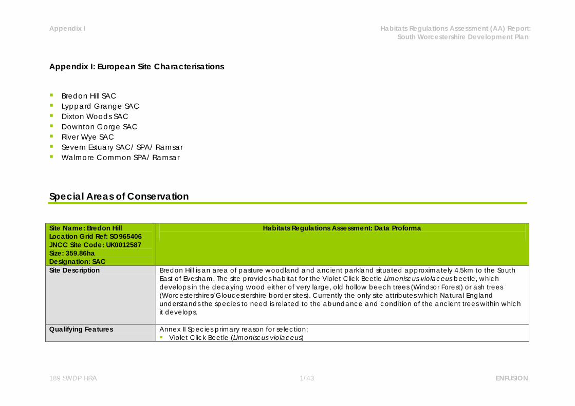
Appendix I: European Site Characterisations Bredon Hill SAC Lyppard Grange SAC Dixton Woods SAC Downton Gorge SAC River Wye SAC Severn Estuary SAC/ SPA/ Ramsar Walmore Common SPA/ Ramsar Special Areas of Conservation
Site Name: Bredon Hill Location Grid Ref: SO965406 JNCC Site Code: UK0012587 Size: 359.86ha Designation: SAC
Habitats Regulations Assessment: Data Proforma
Site Description Bredon Hill is an area of pasture woodland and ancient parkland situated approximately 4.5km to the South East of Evesham. The site provides habitat for the Violet Click Beetle Limoniscus violaceus beetle, which develops in the decaying wood either of very large, old hollow beech trees (Windsor Forest) or ash trees (Worcestershires/Gloucestershire border sites). Currently the only site attributes which Natural England understands the species to need is related to the abundance and condition of the ancient trees within which it develops.
Qualifying Features
Annex II Species primary reason for selection: Violet Click Beetle (Limoniscus violaceus)

Appendix I Habitats Regulations Assessment (AA) Report: South Worcestershire Development Plan
189 SWDP HRA 2/43 ENFUSION
Site Name: Bredon Hill Location Grid Ref: SO965406 JNCC Site Code: UK0012587 Size: 359.86ha Designation: SAC
Habitats Regulations Assessment: Data Proforma
Conservation Objectives
Avoid the deterioration of the qualifying natural habitats and the habitats of qualifying species, and the significant disturbance of those qualifying species, ensuring the integrity of the site is maintained and the site makes a full contribution to achieving Favourable Conservation Status of each of the qualifying features. Subject to natural change, to maintain or restore: The extent and distribution of qualifying natural habitats and habitats of qualifying species; The structure and function (including typical species) of qualifying natural habitats and habitats of
qualifying species; The supporting processes on which qualifying natural habitats and habitats of qualifying species rely; The populations of qualifying species; The distribution of qualifying species within the site. Qualifying Features: S1079. Limoniscus violaceus; Violet click beetle
Vulnerabilities (includes existing pressures and trends)
Lack of a replacement generation of trees for the current ancient trees over much of the hill, as many of the younger trees have been removed to increase stock grazing areas; the overall number of ancient trees suitable for Limoniscus violaceus is relatively small.
Acid and nitrogen deposition currently exceed vegetation thresholds at site1. Ozone levels are also above the critical level.
It is very important that no attempt should be made to measure the population size of this species directly, as methods currently available to find the species lead to destruction of its habitat.
1 Habitats Regulations Assessment of the Phase II Revision of the Regional Spatial Strategy for the West Midlands, 2007.

Appendix I Habitats Regulations Assessment (AA) Report: South Worcestershire Development Plan
189 SWDP HRA 3/43 ENFUSION
Site Name: Lyppard Grange Ponds Location Grid Ref: SO879556 JNCC Site Code: UK0030198 Size: 1.09ha Designation: SAC
Habitats Regulations Assessment: Data Proforma
Site Description The site is situated on the outskirts of Worcester set amongst a recent housing development on former pastoral farmland. Lyppard Grange SAC is composed of two ponds in an area of grassland and scrub (public open space). The site provides habitat for Great Crested Newts Triturus cristatus, which are dependent on both the terrestrial habitat (to provide foraging areas and refuge) and aquatic habitat (for breeding).
Qualifying Features
Annex II Species primary reason for selection: Great Crested Newt (Triturus cristatus)
Conservation Objectives
Avoid the deterioration of the qualifying natural habitats and the habitats of qualifying species, and the significant disturbance of those qualifying species, ensuring the integrity of the site is maintained and the site makes a full contribution to achieving Favourable Conservation Status of each of the qualifying features. Subject to natural change, to maintain or restore: The extent and distribution of qualifying natural habitats and habitats of qualifying species; The structure and function (including typical species) of qualifying natural habitats and habitats of
qualifying species; The supporting processes on which qualifying natural habitats and habitats of qualifying species rely; The populations of qualifying species; The distribution of qualifying species within the site. Qualifying Features: S1166. Triturus cristatus; Great crested newt
Vulnerabilities (includes existing pressures and trends)
Recreational pressure from the public. Introduction of fish - which affect the suitability of ponds as breeding habitats for great crested newts.

Appendix I Habitats Regulations Assessment (AA) Report: South Worcestershire Development Plan
189 SWDP HRA 4/43 ENFUSION
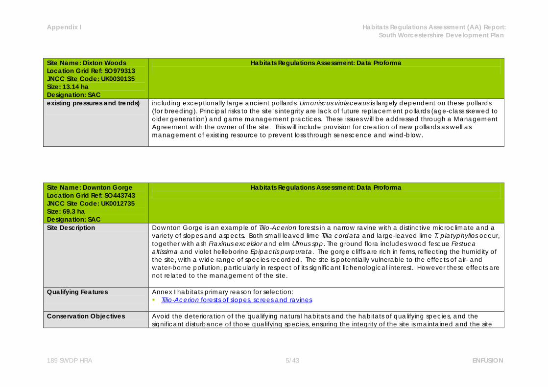
Site Name: Dixton Woods Location Grid Ref: SO979313 JNCC Site Code: UK0030135 Size: 13.14 ha Designation: SAC
Habitats Regulations Assessment: Data Proforma
Site Description Dixton Wood is situated approximately 6.7km to the South East of Tewkesbury and is an area of broadleaved woodland (formerly partially grazed) with a dominance of ash including exceptionally large ancient pollards. The site is designated for its population of Violet Click Beetle Limoniscus violaceaus, which is largely dependent on these pollards (for breeding). Principal risks to the site's integrity are lack of future replacement pollards (age-class skewed to older generation) and game management practices.
Qualifying Features
Annex II species primary reason for selection: Violet click beetle Limoniscus violaceus
Conservation Objectives
Avoid the deterioration of the qualifying natural habitats and the habitats of qualifying species, and the significant disturbance of those qualifying species, ensuring the integrity of the site is maintained and the site makes a full contribution to achieving Favourable Conservation Status of each of the qualifying features. Subject to natural change, to maintain or restore: The extent and distribution of qualifying natural habitats and habitats of qualifying species; The structure and function (including typical species) of qualifying natural habitats and habitats of
qualifying species; The supporting processes on which qualifying natural habitats and habitats of qualifying species rely; The populations of qualifying species; The distribution of qualifying species within the site. Qualifying Features: S1079. Limoniscus violaceus; Violet click beetle
Vulnerabilities (includes Dixton Wood is an area of broadleaved woodland (formerly partially grazed) with a dominance of ash
Appendix I Habitats Regulations Assessment (AA) Report: South Worcestershire Development Plan
189 SWDP HRA 5/43 ENFUSION
Site Name: Dixton Woods Location Grid Ref: SO979313 JNCC Site Code: UK0030135 Size: 13.14 ha Designation: SAC
Habitats Regulations Assessment: Data Proforma
existing pressures and trends)
including exceptionally large ancient pollards. Limoniscus violaceaus is largely dependent on these pollards (for breeding). Principal risks to the site’s integrity are lack of future replacement pollards (age-class skewed to older generation) and game management practices. These issues will be addressed through a Management Agreement with the owner of the site. This will include provision for creation of new pollards as well as management of existing resource to prevent loss through senescence and wind-blow.
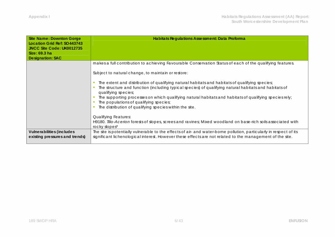
Site Name: Downton Gorge Location Grid Ref: SO443743 JNCC Site Code: UK0012735 Size: 69.3 ha Designation: SAC
Habitats Regulations Assessment: Data Proforma
Site Description Downton Gorge is an example of Tilio-Acerion forests in a narrow ravine with a distinctive microclimate and a variety of slopes and aspects. Both small leaved lime Tilia cordata and large-leaved lime T. platyphyllos occur, together with ash Fraxinus excelsior and elm Ulmus spp. The ground flora includes wood fescue Festuca altissima and violet helleborine Epipactis purpurata. The gorge cliffs are rich in ferns, reflecting the humidity of the site, with a wide range of species recorded. The site is potentially vulnerable to the effects of air- and water-borne pollution, particularly in respect of its significant lichenological interest. However these effects are not related to the management of the site.
Qualifying Features
Annex I habitats primary reason for selection: Tilio-Acerion forests of slopes, screes and ravines
Conservation Objectives
Avoid the deterioration of the qualifying natural habitats and the habitats of qualifying species, and the significant disturbance of those qualifying species, ensuring the integrity of the site is maintained and the site
Appendix I Habitats Regulations Assessment (AA) Report: South Worcestershire Development Plan
189 SWDP HRA 6/43 ENFUSION
Site Name: Downton Gorge Location Grid Ref: SO443743 JNCC Site Code: UK0012735 Size: 69.3 ha Designation: SAC
Habitats Regulations Assessment: Data Proforma
makes a full contribution to achieving Favourable Conservation Status of each of the qualifying features. Subject to natural change, to maintain or restore: The extent and distribution of qualifying natural habitats and habitats of qualifying species; The structure and function (including typical species) of qualifying natural habitats and habitats of
qualifying species; The supporting processes on which qualifying natural habitats and habitats of qualifying species rely; The populations of qualifying species; The distribution of qualifying species within the site. Qualifying Features: H9180. Tilio-Acerion forests of slopes, screes and ravines; Mixed woodland on base-rich soils associated with rocky slopes*
Vulnerabilities (includes existing pressures and trends)
The site is potentially vulnerable to the effects of air- and water-borne pollution, particularly in respect of its significant lichenological interest. However these effects are not related to the management of the site.

Appendix I Habitats Regulations Assessment (AA) Report: South Worcestershire Development Plan
189 SWDP HRA 7/43 ENFUSION
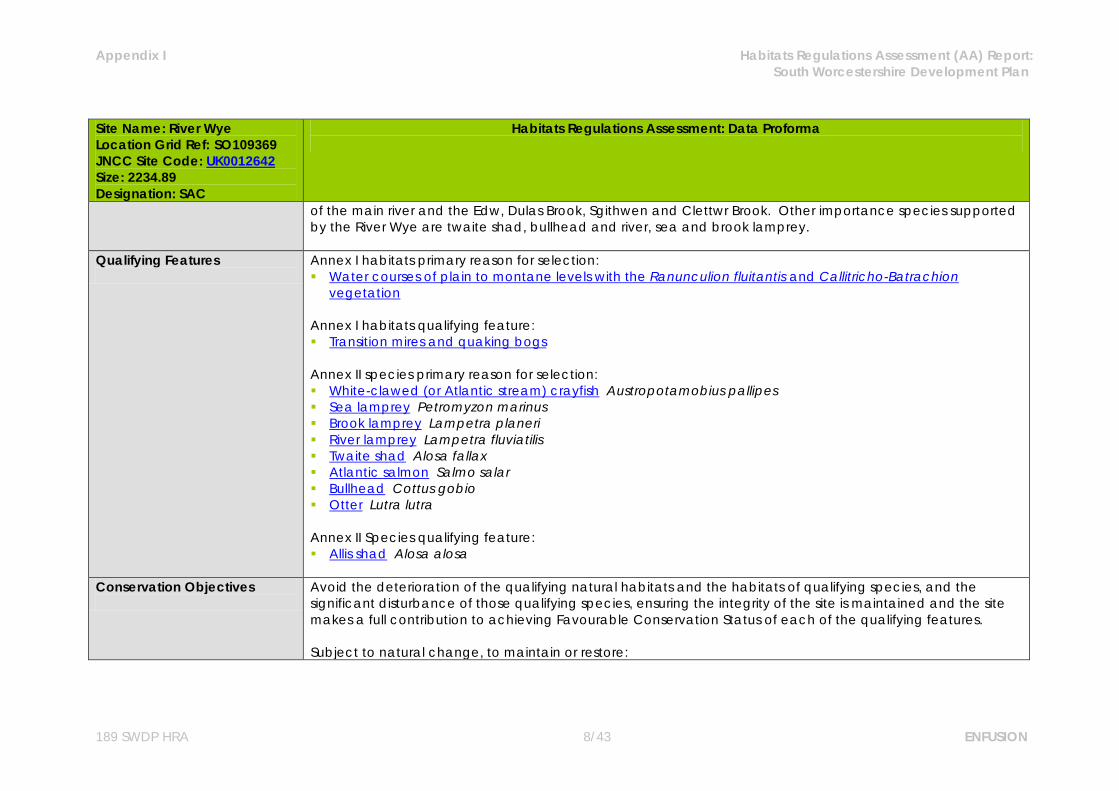
Site Name: River Wye Location Grid Ref: SO109369 JNCC Site Code: UK0012642 Size: 2234.89 Designation: SAC
Habitats Regulations Assessment: Data Proforma
Site Description The River Wye rises on Plynlimon in the Cambrian Mountains and flows in a generally south-easterly direction to enter the Severn Estuary at Chepstow. The upper catchment comprises several large sub-catchments, including the Irfon on the generally infertile upland landscape in the north-west, the Ithon in the north-east often on more low-lying, fertile terrain and the Lugg in the east in a predominantly low-lying fertile landscape much of which lies within England. The underlying geology consists predominantly of impermeable, acidic rocks of Silurian and Ordovician age in the north-west and more permeable Devonian Old Red Sandstone with a moderate base status in the middle and lower catchment. This geology produces a generally low to moderate nutrient status and a low to moderate base-flow index, making the river characteristically flashy. The run-off characteristics and nutrient status are significantly modified by land use in the catchment, which is predominantly pastoral with some woodland and commercial forestry in the headwaters and arable in the lower catchment and the Lugg. The Wye catchment is divided between Wales and England; the river forms the border from south of Monmouth to Chepstow and to the east of Hay-on-Wye. Historically, the Wye is the most famous and productive river in Wales for Atlantic salmon Salmo salar, with high-quality spawning grounds and juvenile habitat in both the main channel and tributaries. The Wye salmon population is particularly notable for the very high proportion (around 75%) of multi sea winter (MSW) fish, a stock component which has declined sharply in recent years throughout the UK. This pattern has also occurred in the Wye, with a consequent marked decline in the population since the 1980s. However, the Wye salmon population is still of considerable importance in UK terms. The Atlantic salmon is the focus for much of the management activity carried out on the Wye. The relatively demanding water quality and spawning substrate quality requirements of this feature mean that reduction in diffuse pollution and siltation impacts is a high priority. The Wye also holds the densest and most well-established otter Lutra lutra population in Wales, representative of otters occurring in lowland freshwater habitats in the borders of Wales. The river has bank-side vegetation cover, abundant food supply, clean water and undisturbed areas of dense scrub suitable for breeding, making it particularly favourable as otter habitat. The population remained even during the lowest point of the UK decline, confirming that the site is particularly favourable for this species and the population likely to be highly stable. The site is considered one of the best in the UK for white-clawed crayfish Austropotamobius pallipes. The tributaries are the main haven for the species, particularly at the confluences
Appendix I Habitats Regulations Assessment (AA) Report: South Worcestershire Development Plan
189 SWDP HRA 8/43 ENFUSION
Site Name: River Wye Location Grid Ref: SO109369 JNCC Site Code: UK0012642 Size: 2234.89 Designation: SAC
Habitats Regulations Assessment: Data Proforma
of the main river and the Edw, Dulas Brook, Sgithwen and Clettwr Brook. Other importance species supported by the River Wye are twaite shad, bullhead and river, sea and brook lamprey.
Qualifying Features
Annex I habitats primary reason for selection: Water courses of plain to montane levels with the Ranunculion fluitantis and Callitricho-Batrachion
vegetation Annex I habitats qualifying feature: Transition mires and quaking bogs Annex II species primary reason for selection: White-clawed (or Atlantic stream) crayfish Austropotamobius pallipes Sea lamprey Petromyzon marinus Brook lamprey Lampetra planeri River lamprey Lampetra fluviatilis Twaite shad Alosa fallax Atlantic salmon Salmo salar Bullhead Cottus gobio Otter Lutra lutra Annex II Species qualifying feature: Allis shad Alosa alosa
Conservation Objectives
Avoid the deterioration of the qualifying natural habitats and the habitats of qualifying species, and the significant disturbance of those qualifying species, ensuring the integrity of the site is maintained and the site makes a full contribution to achieving Favourable Conservation Status of each of the qualifying features. Subject to natural change, to maintain or restore:

Appendix I Habitats Regulations Assessment (AA) Report: South Worcestershire Development Plan
189 SWDP HRA 9/43 ENFUSION
Site Name: River Wye Location Grid Ref: SO109369 JNCC Site Code: UK0012642 Size: 2234.89 Designation: SAC
Habitats Regulations Assessment: Data Proforma
The extent and distribution of qualifying natural habitats and habitats of qualifying species; The structure and function (including typical species) of qualifying natural habitats and habitats of
qualifying species; The supporting processes on which qualifying natural habitats and habitats of qualifying species rely; The populations of qualifying species; The distribution of qualifying species within the site. Qualifying Features: H3260. Water courses of plain to montane levels with the Ranunculion fluitantis and Callitricho-Batrachion vegetation; Rivers with floating vegetation often dominated by water-crowfoot H7140. Transition mires and quaking bogs; Very wet mires often identified by an unstable `quaking` surface S1092. Austropotamobius pallipes; White-clawed (or Atlantic stream) crayfish S1095. Petromyzon marinus; Sea lamprey S1096. Lampetra planeri; Brook lamprey S1099. Lampetra fluviatilis; River lamprey S1102. Alosa alosa; Allis shad S1103. Alosa fallax; Twaite shad S1106. Salmo salar; Atlantic salmon S1163. Cottus gobio; Bullhead S1355. Lutra lutra; Otter
Vulnerabilities (includes existing pressures and trends)
Abstraction levels - entrainment in water abstractions directly impacts on species population dynamics through reduced recruitment and survival rates. The impact of flow depletion resulting from a small number of major abstractions was highlighted in the Review of Consents process. As a result of this process, flow targets have been set which are considered likely to significantly reduce or remove the potential impacts on SAC features.
Eutrophication - factors that are important to the favourable conservation status of this feature include flow,
Appendix I Habitats Regulations Assessment (AA) Report: South Worcestershire Development Plan
189 SWDP HRA 10/43 ENFUSION
Site Name: River Wye Location Grid Ref: SO109369 JNCC Site Code: UK0012642 Size: 2234.89 Designation: SAC
Habitats Regulations Assessment: Data Proforma
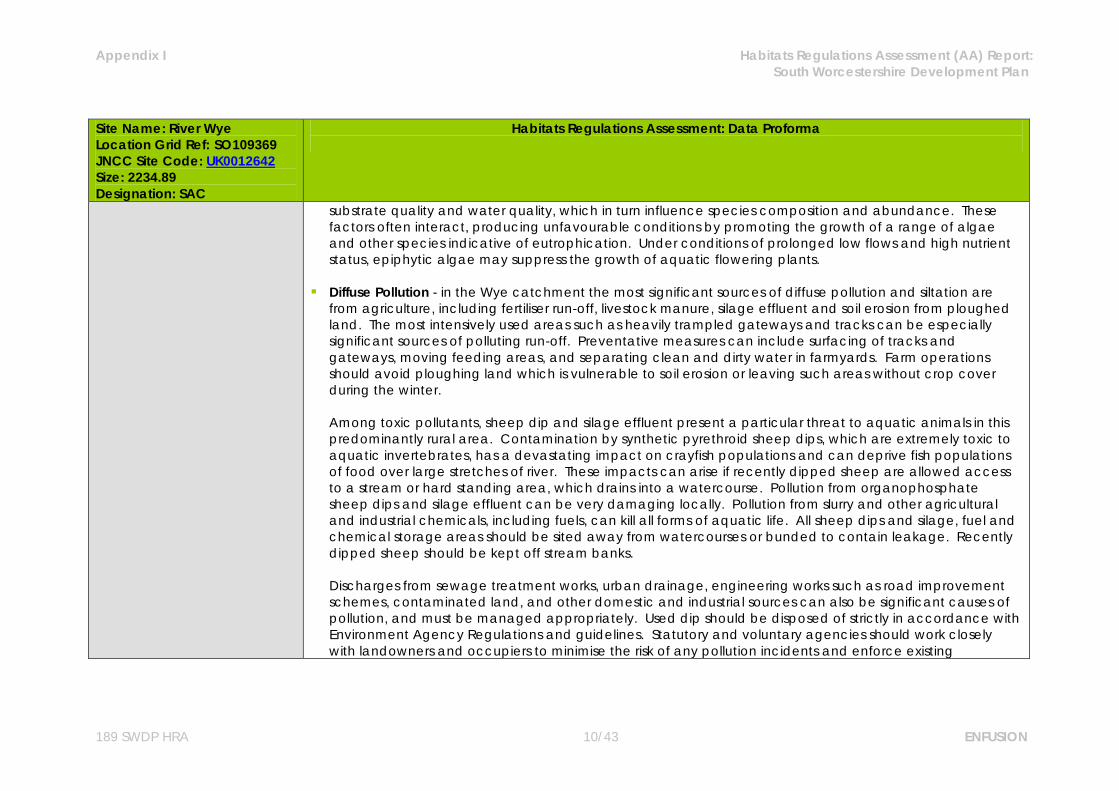
substrate quality and water quality, which in turn influence species composition and abundance. These factors often interact, producing unfavourable conditions by promoting the growth of a range of algae and other species indicative of eutrophication. Under conditions of prolonged low flows and high nutrient status, epiphytic algae may suppress the growth of aquatic flowering plants.
Diffuse Pollution - in the Wye catchment the most significant sources of diffuse pollution and siltation are
from agriculture, including fertiliser run-off, livestock manure, silage effluent and soil erosion from ploughed land. The most intensively used areas such as heavily trampled gateways and tracks can be especially significant sources of polluting run-off. Preventative measures can include surfacing of tracks and gateways, moving feeding areas, and separating clean and dirty water in farmyards. Farm operations should avoid ploughing land which is vulnerable to soil erosion or leaving such areas without crop cover during the winter.
Among toxic pollutants, sheep dip and silage effluent present a particular threat to aquatic animals in this predominantly rural area. Contamination by synthetic pyrethroid sheep dips, which are extremely toxic to aquatic invertebrates, has a devastating impact on crayfish populations and can deprive fish populations of food over large stretches of river. These impacts can arise if recently dipped sheep are allowed access to a stream or hard standing area, which drains into a watercourse. Pollution from organophosphate sheep dips and silage effluent can be very damaging locally. Pollution from slurry and other agricultural and industrial chemicals, including fuels, can kill all forms of aquatic life. All sheep dips and silage, fuel and chemical storage areas should be sited away from watercourses or bunded to contain leakage. Recently dipped sheep should be kept off stream banks. Discharges from sewage treatment works, urban drainage, engineering works such as road improvement schemes, contaminated land, and other domestic and industrial sources can also be significant causes of pollution, and must be managed appropriately. Used dip should be disposed of strictly in accordance with Environment Agency Regulations and guidelines. Statutory and voluntary agencies should work closely with landowners and occupiers to minimise the risk of any pollution incidents and enforce existing

Appendix I Habitats Regulations Assessment (AA) Report: South Worcestershire Development Plan
189 SWDP HRA 11/43 ENFUSION
Site Name: River Wye Location Grid Ref: SO109369 JNCC Site Code: UK0012642 Size: 2234.89 Designation: SAC
Habitats Regulations Assessment: Data Proforma
regulations. Measures to control diffuse pollution in the water environment, including ‘Catchment Sensitive Farming’, may be implemented as a result of the Water Framework Directive and, along with existing agri-environment schemes, will help to achieve the conservation objectives for the SAC. Pollution of rivers with toxic chemicals, such as PCBs, was one of the major factors identified in the widespread decline of otters during the last century. There should be no increase in pollutants potentially toxic to otters.
Barriers to migration - Artificial obstructions including weirs and bridge sills can reduce connectivity for some species. In addition, reaches subject to depleted flow levels, pollution, or disturbance due to noise, vibration or light, can all inhibit the movement of sensitive species. The dispersal of semi-terrestrial species, such as the otter, can be adversely affected by structures such as bridges under certain flow conditions, therefore these must be designed to allow safe passage.
Development pressure - can cause temporary physical, acoustic, chemical and sediment barrier effects
that need to be addressed in the assessment of specific plans and projects. Noise/vibration eg. due to impact piling, drilling, salmon fish counters present within or in close proximity to the river can create a barrier to shad migration. Barriers resulting from vibration, chemicals, low dissolved oxygen and artificially high sediment levels must be prevented at key times. Engineering works such as bridge repairs in reaches where white-clawed crayfish are known to occur should include appropriate pollution prevention measures and a crayfish rescue by a suitably licensed person where there is a risk of physical damage to crayfish.
Invasive and non-native species - are a detrimental impact on the water courses of plain to montane levels
with the Ranunculion fluitantis and Callitricho-Batrachion vegetation. Giant hogweed, Himalayan balsam and Japanese knotweed should be actively managed to control their spread and hopefully reduce their extent in the SAC. The American signal crayfish is present in the Wye catchment and poses a very serious threat to the continued existence of the native white-clawed crayfish in the site and in Wales. Native crayfish are unable to co-exist where signal crayfish are present, due to the latter’s superior competitive ability and a disease, crayfish plague, which it carries but to which native crayfish have no immunity. American signal crayfish and crayfish plague are widespread and abundant in nearby catchments such as
Appendix I Habitats Regulations Assessment (AA) Report: South Worcestershire Development Plan
189 SWDP HRA 12/43 ENFUSION
Site Name: River Wye Location Grid Ref: SO109369 JNCC Site Code: UK0012642 Size: 2234.89 Designation: SAC
Habitats Regulations Assessment: Data Proforma
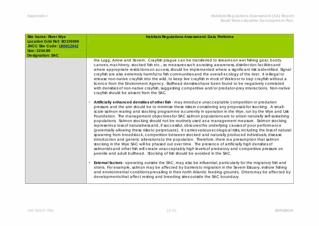
the Lugg, Arrow and Severn. Crayfish plague can be transferred to streams on wet fishing gear, boots, canoes, machinery, stocked fish etc., so measures such as raising awareness, disinfection facilities and where appropriate restrictions on access, should be implemented where a significant risk is identified. Signal crayfish are also extremely harmful to fish communities and the overall ecology of the river. It is illegal to release non-native crayfish into the wild, to keep live crayfish in most of Wales or to trap crayfish without a licence from the Environment Agency. Bullhead densities have been found to be negatively correlated with densities of non-native crayfish, suggesting competitive and/or predator-prey interactions. Non-native crayfish should be absent from the SAC.
Artificially enhanced densities of other fish - may introduce unacceptable competition or predation
pressure and the aim should be to minimise these risks in considering any proposals for stocking. A small-scale salmon rearing and stocking programme is currently in operation in the Wye, run by the Wye and Usk Foundation. The management objectives for SAC salmon populations are to attain naturally self-sustaining populations. Salmon stocking should not be routinely used as a management measure. Salmon stocking represents a loss of naturalness and, if successful, obscures the underlying causes of poor performance (potentially allowing these risks to perpetuate). It carries various ecological risks, including the loss of natural spawning from broodstock, competition between stocked and naturally produced individuals, disease introduction and genetic alterations to the population. Therefore, there is a presumption that salmon stocking in the Wye SAC will be phased out over time. The presence of artificially high densities of salmonids and other fish will create unacceptably high levels of predatory and competitive pressure on juvenile and adult bullhead. Stocking of fish should be avoided in the SAC.
External factors - operating outside the SAC, may also be influential, particularly for the migratory fish and
otters. For example, salmon may be affected by barriers to migration in the Severn Estuary, inshore fishing and environmental conditions prevailing in their north Atlantic feeding grounds. Otters may be affected by developments that affect resting and breeding sites outside the SAC boundary.
Appendix I Habitats Regulations Assessment (AA) Report: South Worcestershire Development Plan
189 SWDP HRA 13/43 ENFUSION
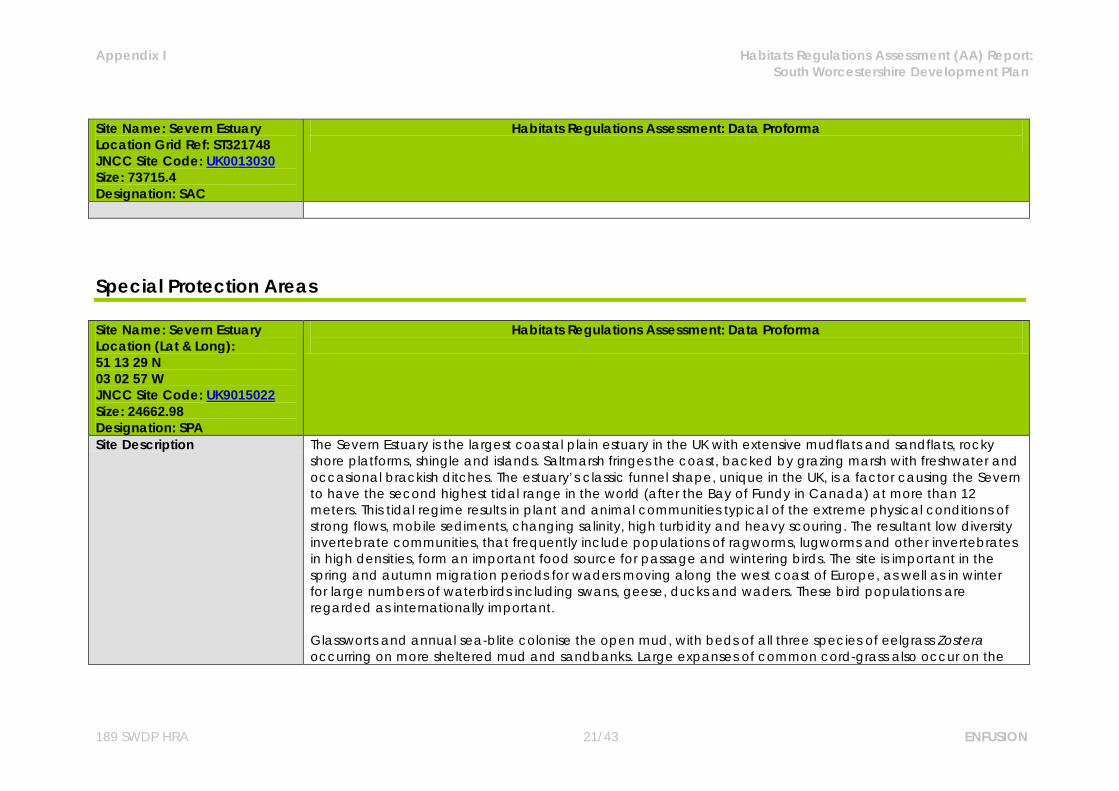
Site Name: Severn Estuary Location Grid Ref: ST321748 JNCC Site Code: UK0013030 Size: 73715.4 Designation: SAC
Habitats Regulations Assessment: Data Proforma
Site Description The Severn Estuary is the largest coastal plain estuary in the UK with extensive mudflats and sandflats, rocky shore platforms, shingle and islands. Saltmarsh fringes the coast, backed by grazing marsh with freshwater and occasional brackish ditches. The estuary’s classic funnel shape, unique in the UK, is a factor causing the Severn to have the second highest tidal range in the world (after the Bay of Fundy in Canada) at more than 12 meters. This tidal regime results in plant and animal communities typical of the extreme physical conditions of strong flows, mobile sediments, changing salinity, high turbidity and heavy scouring. The resultant low diversity invertebrate communities, that frequently include populations of ragworms, lugworms and other invertebrates in high densities, form an important food source for passage and wintering birds. The site is important in the spring and autumn migration periods for waders moving along the west coast of Europe, as well as in winter for large numbers of waterbirds including swans, geese, ducks and waders. These bird populations are regarded as internationally important. Glassworts and annual sea-blite colonise the open mud, with beds of all three species of eelgrass Zostera occurring on more sheltered mud and sandbanks. Large expanses of common cord-grass also occur on the outer marshes. Heavily grazed saltmarsh fringes the estuary with a range of saltmarsh types present. The middle marsh sward is dominated by common saltmarsh-grass with typical associated species. In the upper marsh, red fescue and saltmarsh rush become more prominent. Areas of saltmarsh fringe the estuary, mostly grazed with a range of vegetation communities. There are gradual and stepped transitions between bare mudflat to upper marsh and grassland. Main vegetation types are: upper saltmarsh with Festuca rubra and Juncus gerardii; middle marsh dominated by Puccinellia maritima with Glaux maritima and Triglochin maritima; dense monocultures of Spartina anglica at the edge of the mudflats-brackish pools and depressions with Phragmites australis and Bolboschoenus maritimus.
Qualifying Features Annex I Habitats primary reason for selection:

Appendix I Habitats Regulations Assessment (AA) Report: South Worcestershire Development Plan
189 SWDP HRA 14/43 ENFUSION
Site Name: Severn Estuary Location Grid Ref: ST321748 JNCC Site Code: UK0013030 Size: 73715.4 Designation: SAC
Habitats Regulations Assessment: Data Proforma
Estuaries Mudflats and sandflats not covered by seawater at low tide Atlantic salt meadows (Glauco-Puccinellietalia maritimae) Annex I Habitats qualifying feature: Sandbanks which are slightly covered by sea water all the time Reefs Annex II Species primary reason for selection: Sea lamprey Petromyzon marinus River lamprey Lampetra fluviatilis Twaite shad Alosa fallax
Conservation Objectives
SAC interest feature 1: Estuaries The conservation objective for the “estuaries” feature of the Severn Estuary SAC is to maintain the feature in favourable condition, as defined below: The feature will be considered to be in favourable condition when, subject to natural processes, each of the following conditions are met: i. the total extent of the estuary is maintained; ii. the characteristic physical form (tidal prism/cross sectional area) and flow (tidal regime) of the estuary
is maintained; iii. the characteristic range and relative proportions of sediment sizes and sediment budget within the site
is maintained; iv. the extent, variety and spatial distribution of estuarine habitat communities5 within the site is

Appendix I Habitats Regulations Assessment (AA) Report: South Worcestershire Development Plan
189 SWDP HRA 15/43 ENFUSION
Site Name: Severn Estuary Location Grid Ref: ST321748 JNCC Site Code: UK0013030 Size: 73715.4 Designation: SAC
Habitats Regulations Assessment: Data Proforma
maintained; v. the extent, variety, spatial distribution and community composition of hard substrate habitats and their
notable communities is maintained; vi. the abundance of the notable estuarine species assemblages7 is maintained or increased; vii. the physico-chemical characteristics of the water column9 support the ecological objectives
described above; viii. Toxic contaminants in water column and sediment are below levels which would pose a risk to the
ecological objectives described above. ix. Airborne nutrient and contaminant loads are below levels which would pose a risk to the ecological
objectives described above SAC interest feature 2: Subtidal sandbanks which are covered by sea water all the time (subtidal sandbanks) The conservation objective for the “subtidal sandbanks” feature of the Severn Estuary SAC is to maintain the feature in favourable condition, as defined below: The feature will be considered to be in favourable condition when, subject to natural processes, each of the following conditions are met: i. the total extent of the subtidal sandbanks within the site is maintained; ii. the extent and distribution of the individual subtidal sandbank communities within the site is
maintained; iii. the community composition of the subtidal sandbank feature within the site is maintained; iv. the variety and distribution of sediment types across the subtidal sandbank feature is maintained; v. the gross morphology (depth, distribution and profile) of the subtidal sandbank feature within the site is
maintained. SAC interest feature 3: Mudflats and sandflats not covered by seawater at low tide (mudflats and sandflats)

Appendix I Habitats Regulations Assessment (AA) Report: South Worcestershire Development Plan
189 SWDP HRA 16/43 ENFUSION
Site Name: Severn Estuary Location Grid Ref: ST321748 JNCC Site Code: UK0013030 Size: 73715.4 Designation: SAC
Habitats Regulations Assessment: Data Proforma
The conservation objective for “mudflats and sandflats” feature of the Severn Estuary SAC is to maintain the feature in favourable condition, as defined below: The feature will be considered to be in favourable condition when, subject to natural processes, each of the following conditions are met: i. The total extent of the mudflats and sandflats feature is maintained; ii. the variety and extent of individual mudflats and sandflats communities within the site is maintained; iii. the distribution of individual mudflats and sandflats communities3 within the site is maintained; iv. the community composition of the mudflats and sandflats feature within the site is maintained; v. the topography of the intertidal flats and the morphology (dynamic processes of sediment movement
and channel migration across the flats) are maintained. SAC interest feature 4: Atlantic salt meadow The conservation objective for the “Atlantic salt meadow” feature of the Severn Estuary SAC is to maintain the feature in favourable condition, as defined below: The feature will be considered to be in favourable condition when, subject to natural processes, each of the following conditions are met: i. the total extent of Atlantic salt meadow and associated transitional vegetation communities within the
site is maintained; ii. the extent and distribution of the individual Atlantic salt meadow and associated transitional
vegetation communities within the site is maintained; iii. the zonation of Atlantic salt meadow vegetation communities and their associated transitions to other
estuary habitats is maintained;

Appendix I Habitats Regulations Assessment (AA) Report: South Worcestershire Development Plan
189 SWDP HRA 17/43 ENFUSION
Site Name: Severn Estuary Location Grid Ref: ST321748 JNCC Site Code: UK0013030 Size: 73715.4 Designation: SAC
Habitats Regulations Assessment: Data Proforma
iv. the relative abundance of the typical species of the Atlantic salt meadow and associated transitional vegetation communities is maintained;
v. the abundance of the notable species of the Atlantic salt meadow and associated transitional vegetation communities is maintained.
vi. the structural variation of the salt marsh sward (resulting from grazing) is maintained within limits sufficient to satisfy the requirements of conditions iv and v above and the requirements of the Ramsar and SPA features
vii. the characteristic stepped morphology of the salt marshes and associated creeks, pills, drainage ditches and pans, and the estuarine processes that enable their development, is maintained.
viii. Any areas of Spartina anglica salt marsh (SM6) are capable of developing naturally into other saltmarsh communities.
SAC interest feature 5: Reefs The conservation objective for the “reefs” feature of the Severn Estuary SAC is to maintain the feature in a favourable condition, as defined below: The feature will be considered to be in favourable condition when, subject to natural processes, each of the following conditions are met: i. the total extent and distribution of Sabellaria reef is maintained; ii. the community composition of the Sabellaria reef is maintained; iii. the full range of different age structures of Sabellaria reef are present; iv. the physical5and ecological processes necessary to support Sabellaria reef are maintained. SAC interest feature 6: River lamprey Lampetra fluviatilis The conservation objective for the river lamprey Lampetra fluviatilis feature of the Severn Estuary SAC is to
Appendix I Habitats Regulations Assessment (AA) Report: South Worcestershire Development Plan
189 SWDP HRA 18/43 ENFUSION
Site Name: Severn Estuary Location Grid Ref: ST321748 JNCC Site Code: UK0013030 Size: 73715.4 Designation: SAC
Habitats Regulations Assessment: Data Proforma
maintain the feature in a favourable condition, as defined below: The feature will be considered to be in favourable condition when, subject to natural processes, each of the following conditions are met: i. the migratory passage of both adult and juvenile river lamprey through the Severn Estuary between
the Bristol Channel and any of their spawning rivers is not obstructed or impeded by physical barriers, changes in flows, or poor water quality;
ii. the size of the river lamprey population in the Severn Estuary and the rivers which drain into it, is at least maintained and is at a level that is sustainable in the long term;
iii. the abundance of prey species forming the river lamprey’s food resource within the estuary, is maintained.
iv. Toxic contaminants in the water column and sediment are below levels which would pose a risk to the ecological objectives described above.
SAC interest feature 7: The conservation objective for sea lamprey Petromyzon marinus The conservation objective for the sea lamprey Petromyzon marinus feature of the Severn Estuary SAC is to maintain the feature in a favourable condition, as defined below: The feature will be considered to be in favourable condition when, subject to natural processes, each of the following conditions are met: i. the migratory passage of both adult and juvenile sea lamprey through the Severn Estuary between the
Bristol Channel and any of their spawning rivers is not obstructed or impeded by physical barriers, changes in flows, or poor water quality;
ii. the size of the sea lamprey population in the Severn Estuary and the rivers which drain into it, is at least maintained as is at a level that is sustainable in the long term;
Appendix I Habitats Regulations Assessment (AA) Report: South Worcestershire Development Plan
189 SWDP HRA 19/43 ENFUSION
Site Name: Severn Estuary Location Grid Ref: ST321748 JNCC Site Code: UK0013030 Size: 73715.4 Designation: SAC
Habitats Regulations Assessment: Data Proforma
iii. the abundance of prey species forming the sea lamprey’s food resource within the estuary, is maintained.
vi. Toxic contaminants in the water column and sediment are below levels which would pose a risk to the ecological objectives described above.
SAC interest feature 8: The conservation objective for twaite shad Alosa fallax The conservation objective for the twaite Shad Alosa fallax feature of the Severn Estuary SAC is to maintain the feature in a favourable condition, as defined below: The feature will be considered to be in favourable condition when, subject to natural processes, each of the following conditions are met: i. the migratory passage of both adult and juvenile twaite shad through the Severn Estuary between the
Bristol Channel and their spawning rivers is not obstructed or impeded by physical barriers, changes in flows or poor water quality;
ii. the size of the twaite shad population within the Severn Estuary and the rivers draining into it is at least maintained and is at a level that is sustainable in the long term.
iii. the abundance of prey species forming the twaite shad’s food resource within the estuary, in particular at the salt wedge, is maintained.
iv. Toxic contaminants in the water column and sediment are below levels which would pose a risk to the ecological objectives described above.
Vulnerabilities (includes existing pressures and trends)
Physical loss of supporting habitats through removal - The physical loss of areas of intertidal habitats may be caused directly through change of land use or indirectly as a consequence of changes to sedimentation processes (e.g. coastal defences) as well as via the effects of smothering by artificial structures (e.g. jetties) or the disposal of spoils. The intertidal mudflats and sandflats and the saltmarsh are highly sensitive to removal by land reclamation and barrage construction. Information provided by NE and CCW states that
Appendix I Habitats Regulations Assessment (AA) Report: South Worcestershire Development Plan
189 SWDP HRA 20/43 ENFUSION
Site Name: Severn Estuary Location Grid Ref: ST321748 JNCC Site Code: UK0013030 Size: 73715.4 Designation: SAC
Habitats Regulations Assessment: Data Proforma
large areas of the European marine site are not currently under threat, however when combined with a high level of sensitivity this leads to a moderate vulnerability.
Contamination by synthetic and/or non-synthetic toxic compounds - At the moment there is no evidence
to show that this is the case on the Severn Estuary, but the estuary is vulnerable to oil spills and there is a continuous discharge of toxins into the estuary, some of which bind to the sediments. NE and CCW identify this is an area which requires further assessment. The intertidal mudflats and sandflats and the saltmarsh are currently highly vulnerable to the introduction of synthetic and non-synthetic compounds.
Damage by abrasion or selective extraction - Saltmarsh may be physically damaged from overgrazing or
eroded when boats are moored on it and when paths are worn through it to reach moored boats on foot or via vehicles. Currently all supporting habitats are considered to be moderately vulnerable to abrasion. Intertidal habitats are highly sensitive to damage by direct and indirect effects of aggregate dredging. The intertidal mudflats and sandflats and the shingle and rocky shore are therefore considered by NE and CCW to be highly vulnerable to selective extraction.
Changes in nutrient and/or organic loading - Changes in organic or nutrient loading can change the
species composition of the plants on the saltmarsh and thus the structure of the sward. Increases in nutrients can also cause excessive algal growth on the mudflats, denying the birds access to their invertebrate prey and changing the invertebrate species composition in the sediment. Though the water quality has been improved in recent years there are still local areas of concern and any increase in nutrient loading should be avoided. At present the intertidal mudflats and sandflats are moderately vulnerable to this category of operation.
Inappropriate grazing - Much of the saltmarsh is managed by grazing and changes in management can
alter the availability of prey and suitability of roosting sites. The saltmarsh is currently highly vulnerable to the selective extraction of species.
Appendix I Habitats Regulations Assessment (AA) Report: South Worcestershire Development Plan
189 SWDP HRA 21/43 ENFUSION
Site Name: Severn Estuary Location Grid Ref: ST321748 JNCC Site Code: UK0013030 Size: 73715.4 Designation: SAC
Habitats Regulations Assessment: Data Proforma
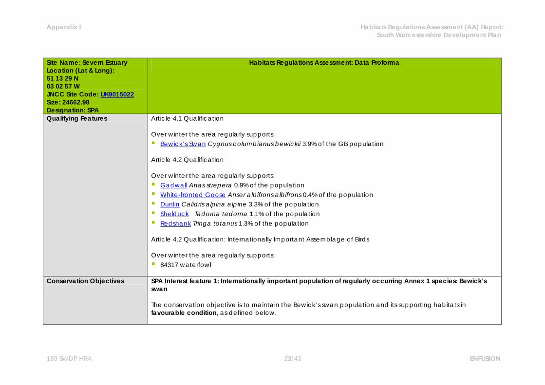
Special Protection Areas Site Name: Severn Estuary Location (Lat & Long): 51 13 29 N 03 02 57 W JNCC Site Code: UK9015022 Size: 24662.98 Designation: SPA
Habitats Regulations Assessment: Data Proforma
Site Description The Severn Estuary is the largest coastal plain estuary in the UK with extensive mudflats and sandflats, rocky shore platforms, shingle and islands. Saltmarsh fringes the coast, backed by grazing marsh with freshwater and occasional brackish ditches. The estuary’s classic funnel shape, unique in the UK, is a factor causing the Severn to have the second highest tidal range in the world (after the Bay of Fundy in Canada) at more than 12 meters. This tidal regime results in plant and animal communities typical of the extreme physical conditions of strong flows, mobile sediments, changing salinity, high turbidity and heavy scouring. The resultant low diversity invertebrate communities, that frequently include populations of ragworms, lugworms and other invertebrates in high densities, form an important food source for passage and wintering birds. The site is important in the spring and autumn migration periods for waders moving along the west coast of Europe, as well as in winter for large numbers of waterbirds including swans, geese, ducks and waders. These bird populations are regarded as internationally important. Glassworts and annual sea-blite colonise the open mud, with beds of all three species of eelgrass Zostera occurring on more sheltered mud and sandbanks. Large expanses of common cord-grass also occur on the

Appendix I Habitats Regulations Assessment (AA) Report: South Worcestershire Development Plan
189 SWDP HRA 22/43 ENFUSION
Site Name: Severn Estuary Location (Lat & Long): 51 13 29 N 03 02 57 W JNCC Site Code: UK9015022 Size: 24662.98 Designation: SPA
Habitats Regulations Assessment: Data Proforma
outer marshes. Heavily grazed saltmarsh fringes the estuary with a range of saltmarsh types present. The middle marsh sward is dominated by common saltmarsh-grass with typical associated species. In the upper marsh, red fescue and saltmarsh rush become more prominent. Areas of saltmarsh fringe the estuary, mostly grazed with a range of vegetation communities. There are gradual and stepped transitions between bare mudflat to upper marsh and grassland. Main vegetation types are: upper saltmarsh with Festuca rubra and Juncus gerardii; middle marsh dominated by Puccinellia maritima with Glaux maritima and Triglochin maritima; dense monocultures of Spartina anglica at the edge of the mudflats-brackish pools and depressions with Phragmites australis and Bolboschoenus maritimus.
Appendix I Habitats Regulations Assessment (AA) Report: South Worcestershire Development Plan
189 SWDP HRA 23/43 ENFUSION
Site Name: Severn Estuary Location (Lat & Long): 51 13 29 N 03 02 57 W JNCC Site Code: UK9015022 Size: 24662.98 Designation: SPA
Habitats Regulations Assessment: Data Proforma
Qualifying Features
Article 4.1 Qualification Over winter the area regularly supports: Bewick’s Swan Cygnus columbianus bewickii 3.9% of the GB population Article 4.2 Qualification Over winter the area regularly supports: Gadwall Anas strepera 0.9% of the population White-fronted Goose Anser albifrons albifrons 0.4% of the population Dunlin Calidris alpina alpine 3.3% of the population Shelduck Tadorna tadorna 1.1% of the population Redshank Tringa totanus 1.3% of the population Article 4.2 Qualification: Internationally Important Assemblage of Birds Over winter the area regularly supports: 84317 waterfowl
Conservation Objectives
SPA Interest feature 1: Internationally important population of regularly occurring Annex 1 species: Bewick’s swan The conservation objective is to maintain the Bewick’s swan population and its supporting habitats in favourable condition, as defined below.
Appendix I Habitats Regulations Assessment (AA) Report: South Worcestershire Development Plan
189 SWDP HRA 24/43 ENFUSION
Site Name: Severn Estuary Location (Lat & Long): 51 13 29 N 03 02 57 W JNCC Site Code: UK9015022 Size: 24662.98 Designation: SPA
Habitats Regulations Assessment: Data Proforma
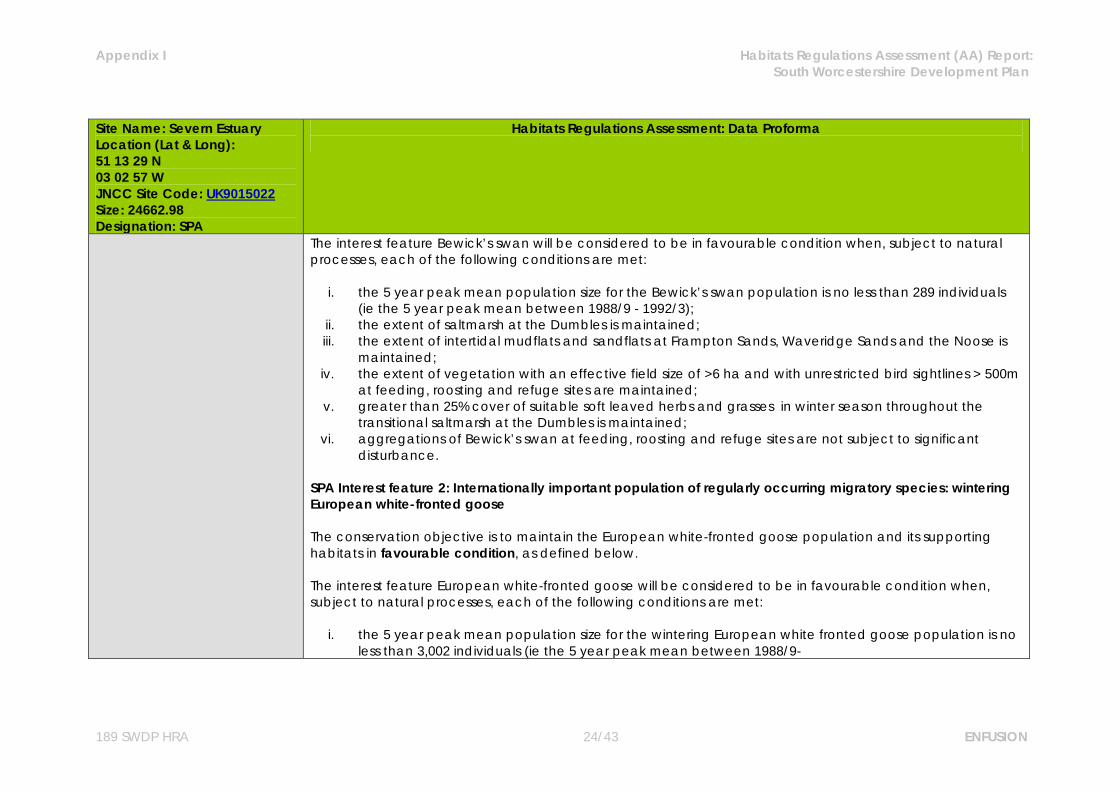
The interest feature Bewick’s swan will be considered to be in favourable condition when, subject to natural processes, each of the following conditions are met:
i. the 5 year peak mean population size for the Bewick’s swan population is no less than 289 individuals (ie the 5 year peak mean between 1988/9 - 1992/3);
ii. the extent of saltmarsh at the Dumbles is maintained; iii. the extent of intertidal mudflats and sandflats at Frampton Sands, Waveridge Sands and the Noose is
maintained; iv. the extent of vegetation with an effective field size of >6 ha and with unrestricted bird sightlines > 500m
at feeding, roosting and refuge sites are maintained; v. greater than 25% cover of suitable soft leaved herbs and grasses in winter season throughout the
transitional saltmarsh at the Dumbles is maintained; vi. aggregations of Bewick’s swan at feeding, roosting and refuge sites are not subject to significant
disturbance. SPA Interest feature 2: Internationally important population of regularly occurring migratory species: wintering European white-fronted goose The conservation objective is to maintain the European white-fronted goose population and its supporting habitats in favourable condition, as defined below. The interest feature European white-fronted goose will be considered to be in favourable condition when, subject to natural processes, each of the following conditions are met:
i. the 5 year peak mean population size for the wintering European white fronted goose population is no less than 3,002 individuals (ie the 5 year peak mean between 1988/9-
Appendix I Habitats Regulations Assessment (AA) Report: South Worcestershire Development Plan
189 SWDP HRA 25/43 ENFUSION
Site Name: Severn Estuary Location (Lat & Long): 51 13 29 N 03 02 57 W JNCC Site Code: UK9015022 Size: 24662.98 Designation: SPA
Habitats Regulations Assessment: Data Proforma
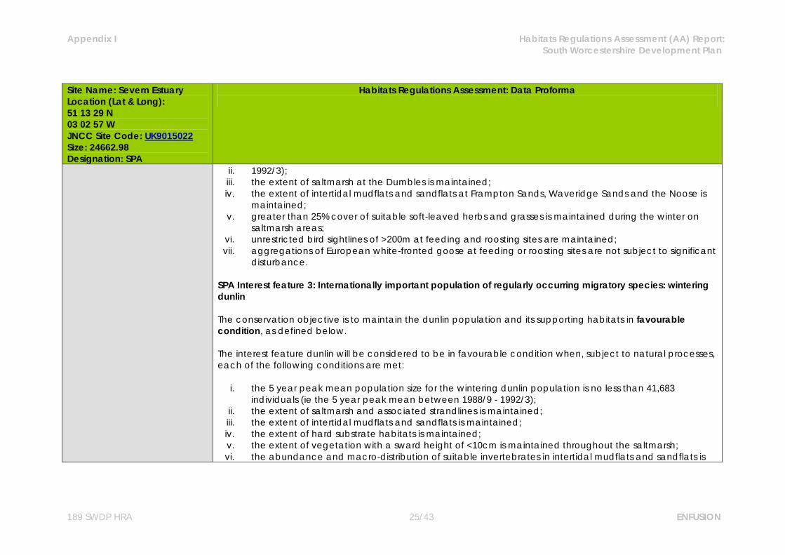
ii. 1992/3); iii. the extent of saltmarsh at the Dumbles is maintained; iv. the extent of intertidal mudflats and sandflats at Frampton Sands, Waveridge Sands and the Noose is
maintained; v. greater than 25% cover of suitable soft-leaved herbs and grasses is maintained during the winter on
saltmarsh areas; vi. unrestricted bird sightlines of >200m at feeding and roosting sites are maintained; vii. aggregations of European white-fronted goose at feeding or roosting sites are not subject to significant
disturbance. SPA Interest feature 3: Internationally important population of regularly occurring migratory species: wintering dunlin The conservation objective is to maintain the dunlin population and its supporting habitats in favourable condition, as defined below. The interest feature dunlin will be considered to be in favourable condition when, subject to natural processes, each of the following conditions are met:
i. the 5 year peak mean population size for the wintering dunlin population is no less than 41,683 individuals (ie the 5 year peak mean between 1988/9 - 1992/3);
ii. the extent of saltmarsh and associated strandlines is maintained; iii. the extent of intertidal mudflats and sandflats is maintained; iv. the extent of hard substrate habitats is maintained; v. the extent of vegetation with a sward height of <10cm is maintained throughout the saltmarsh; vi. the abundance and macro-distribution of suitable invertebrates in intertidal mudflats and sandflats is
Appendix I Habitats Regulations Assessment (AA) Report: South Worcestershire Development Plan
189 SWDP HRA 26/43 ENFUSION
Site Name: Severn Estuary Location (Lat & Long): 51 13 29 N 03 02 57 W JNCC Site Code: UK9015022 Size: 24662.98 Designation: SPA
Habitats Regulations Assessment: Data Proforma
maintained; vii. the abundance and macro-distribution of suitable invertebrates in hard substrate habitats is
maintained; viii. unrestricted bird sightlines of >200m at feeding and roosting sites are maintained; ix. aggregations of dunlin at feeding or roosting sites are not subject to significant disturbance.
SPA Interest feature 4: Internationally important population of regularly occurring migratory species: wintering redshank The conservation objective is to maintain the redshank population and its supporting habitats in favourable condition, as defined below. The interest feature redshank will be considered to be in favourable condition when, subject to natural processes, each of the following conditions are met:
i. the 5 year peak mean population size for the wintering redshank population is no less than 2,013 individuals (ie the 5 year peak mean between 1988/9 - 1992/3);
ii. the extent of saltmarsh and associated strandlines is maintained; iii. the extent of intertidal mudflats and sandflats is maintained; iv. the extent of hard substrate habitats is maintained; v. the extent of vegetation with a sward height of <10cm throughout the saltmarsh is maintained; vi. the abundance and macro-distribution of suitable invertebrates in intertidal mudflats and sandflats is
maintained; vii. the abundance and macro-distribution of suitable invertebrates in hard substrate habitats is
maintained; viii. unrestricted bird sightlines of >200m at feeding and roosting sites are maintained;
Appendix I Habitats Regulations Assessment (AA) Report: South Worcestershire Development Plan
189 SWDP HRA 27/43 ENFUSION
Site Name: Severn Estuary Location (Lat & Long): 51 13 29 N 03 02 57 W JNCC Site Code: UK9015022 Size: 24662.98 Designation: SPA
Habitats Regulations Assessment: Data Proforma
ix. aggregations of redshank at feeding or roosting sites are not subject to significant disturbance. SPA Interest feature 5: Internationally important population of regularly occurring migratory species: wintering shelduck The conservation objective is to maintain the shelduck population and its supporting habitats in favourable condition, as defined below. The interest feature shelduck will be considered to be in favourable condition when, subject to natural processes, each of the following conditions are met:
i. the 5 year peak mean population size for the wintering shelduck population is no less than 2,892 individuals (ie the 5 year peak mean between 1988/9 - 1992/3);
ii. the extent of saltmarsh is maintained; iii. the extent of intertidal mudflats and sandflats is maintained; iv. the extent of hard substrate habitats is maintained; v. the abundance and macro-distribution of suitable invertebrates in intertidal mudflats and sandflats is
maintained; vi. unrestricted bird sightlines of >200m at feeding and roosting sites are maintained; vii. aggregations of shelduck at feeding or roosting sites are not subject to significant disturbance.
SPA interest feature 6: Internationally important population of regularly occurring migratory species: wintering gadwall The conservation objective is to maintain the gadwall population and its supporting habitats in favourable condition, as defined below:

Appendix I Habitats Regulations Assessment (AA) Report: South Worcestershire Development Plan
189 SWDP HRA 28/43 ENFUSION
Site Name: Severn Estuary Location (Lat & Long): 51 13 29 N 03 02 57 W JNCC Site Code: UK9015022 Size: 24662.98 Designation: SPA
Habitats Regulations Assessment: Data Proforma
The interest feature gadwall will be considered to be in favourable condition when, subject to natural processes, each of the following conditions are met: i. the 5 year peak mean population size for the wintering gadwall population is no less than 330 (ie the 5
year peak mean between 1988/9 - 1992/3); ii. the extent of intertidal mudflats and sandflats (Appendix 8) is maintained; iii. unrestricted bird sightlines of >200m at feeding and roosting sites are maintained; iv. aggregations of gadwall at feeding or roosting sites are not subject to significant disturbance. SPA Interest feature 7: Internationally important assemblage of waterfowl The conservation objective is to maintain the waterfowl assemblage and its supporting habitats in favourable condition, as defined below. The interest feature waterfowl assemblage will be considered to be in favourable condition when, subject to natural processes, each of the following conditions are met:
i. the 5 year peak mean population size for the waterfowl assemblage is no less than 68,026 individuals (ie the 5 year peak mean between 1988/9 - 1992/3);
ii. the extent of saltmarsh and their associated strandlines is maintained; iii. the extent of intertidal mudflats and sandflats is maintained; iv. the extent of hard substrate habitats is maintained; v. extent of vegetation of <10cm throughout the saltmarsh is maintained; vi. the abundance and macro-distribution of suitable invertebrates in intertidal mudflats and sandflats is
maintained;
Appendix I Habitats Regulations Assessment (AA) Report: South Worcestershire Development Plan
189 SWDP HRA 29/43 ENFUSION
Site Name: Severn Estuary Location (Lat & Long): 51 13 29 N 03 02 57 W JNCC Site Code: UK9015022 Size: 24662.98 Designation: SPA
Habitats Regulations Assessment: Data Proforma
vii. the abundance and macro-distribution of suitable invertebrates in hard substrate habitats is maintained;
viii. greater than 25% cover of suitable soft leaved herbs and grasses during the winter on saltmarsh areas is maintained;
ix. unrestricted bird sightlines of >500m at feeding and roosting sites are maintained; x. waterfowl aggregations at feeding or roosting sites are not subject to significant disturbance.
Vulnerabilities (includes existing pressures and trends)
Internationally important populations of regularly occurring Annex 1 species: Physical loss of supporting habitats through removal - The physical loss of areas of intertidal habitats may be
caused directly through change of land use or indirectly as a consequence of changes to sedimentation processes (e.g. coastal defences) as well as via the effects of smothering by artificial structures (e.g. jetties) or the disposal of spoils. Activities or developments resulting in physical loss of the intertidal supporting habitats are likely to reduce the availability of feeding and roosting habitat and thus be detrimental to the favourable condition of the SPA interest features including the Annex 1 species, Bewick’s swan. The intertidal mudflats and sandflats and the saltmarsh are highly sensitive to removal by land reclamation and barrage construction. Information provided by NE and CCW states that large areas of the European marine site are not currently under threat, however when combined with a high level of sensitivity this leads to a moderate vulnerability.
Noise or visual disturbance - Overwintering birds are disturbed by sudden movements and sudden noises.
This can displace the birds from their feeding grounds. Disturbance can prevent the birds from feeding and in response they either a) decrease their energy intake at their present (disturbed) feeding site through displacement activity, or b) move to an alternative less favoured feeding site. Such a response affects energy budgets and thus survival. There is intermittent disturbance from both the landward and seaward side of the site. Bewick’s swans are mainly affected by disturbance from the landward side and any
Appendix I Habitats Regulations Assessment (AA) Report: South Worcestershire Development Plan
189 SWDP HRA 30/43 ENFUSION
Site Name: Severn Estuary Location (Lat & Long): 51 13 29 N 03 02 57 W JNCC Site Code: UK9015022 Size: 24662.98 Designation: SPA
Habitats Regulations Assessment: Data Proforma
increase in disturbance should be avoided. At present NE and CCW assess that the Annex 1 species are moderately vulnerable to noise and visual disturbance on the intertidal mudflats and sandflats and highly vulnerable to this category of operation on the saltmarsh.
Contamination by synthetic and/or non-synthetic toxic compounds - Waterfowl are subject to the
accumulation of toxins through the food chain or through direct contact with toxic substances when roosting or feeding. Their ability to feed can also be affected by the abundance or change in palatability of their prey caused by toxic contamination. At the moment there is no evidence to show that this is the case, but the estuary is vulnerable to oil spills and there is a continuous discharge of toxins into the estuary, some of which bind to the sediments. NE and CCW identify this is an area which requires further assessment. They also identify Bewick’s swans as currently moderately vulnerable to toxic contamination.
Internationally important waterfowl assemblage including populations of regularly occurring migratory species: Physical loss through removal - The physical loss of areas of intertidal habitats may be caused directly
through change of land use or indirectly as a consequence of changes to sedimentation processes (e.g. coastal defences) as well as via the effects of smothering by artificial structures (e.g. jetties) or the disposal of spoils. Eelgrass beds are being affected by siltation due to changes in sediment movement after construction of the Second Severn Crossing which has resulted in smothering. Activities or developments resulting in physical loss of the intertidal supporting habitats are likely to reduce the availability of food and roosting habitat and thus be detrimental to the favourable condition of the SPA interest features including all the migratory species and waterfowl assemblage. All three supporting habitats are highly sensitive to removal by land reclamation and barrage construction. Information provided by NE and CCW states that large areas of the European marine site are not currently under threat, however when combined with a high level of sensitivity this leads to a moderate vulnerability.

Appendix I Habitats Regulations Assessment (AA) Report: South Worcestershire Development Plan
189 SWDP HRA 31/43 ENFUSION
Site Name: Severn Estuary Location (Lat & Long): 51 13 29 N 03 02 57 W JNCC Site Code: UK9015022 Size: 24662.98 Designation: SPA
Habitats Regulations Assessment: Data Proforma
Damage by abrasion or selective extraction - Saltmarsh may be physically damaged from overgrazing or
eroded when boats are moored on it and when paths are worn through it to reach moored boats on foot or via vehicles. Currently all supporting habitats are considered to be moderately vulnerable to abrasion. Intertidal habitats are highly sensitive to damage by direct and indirect effects of aggregate dredging. The intertidal mudflats and sandflats and the shingle and rocky shore are therefore considered by NE and CCW to be highly vulnerable to selective extraction.
Noise or visual disturbance - Overwintering birds are disturbed by sudden movements and sudden noises.
This can have the effect of displacing the birds from their feeding grounds. Disturbance can prevent the birds from feeding and in response they either a) decrease their energy intake at their present (disturbed) feeding site through displacement activity, or b) move to an alternative less favoured feeding site. Such a response affects energy budgets and thus survival. There is intermittent disturbance to the internationally important migratory species and the waterfowl assemblage from both the landward and seaward side of the site which has increased in recent years, due to the estuary becoming more populated and the development of all weather recreational pursuits. All supporting habitats are currently highly vulnerable to noise and visual disturbance.
Contamination by synthetic and/or non-synthetic toxic compounds - Waterfowl are subject to the
accumulation of toxins through the food chain or through direct contact with toxic substances when roosting or feeding. Their ability to feed can also be affected by the abundance or change in palatability of their prey caused by toxic contamination. At the moment there is no evidence to show that this is the case on the Severn Estuary, but the estuary is vulnerable to oil spills and there is a continuous discharge of toxins into the estuary, some of which bind to the sediments. NE and CCW identify this is an area which requires further assessment. The intertidal mudflats and sandflats and the saltmarsh are currently highly vulnerable to the introduction of synthetic and non-synthetic compounds.
Appendix I Habitats Regulations Assessment (AA) Report: South Worcestershire Development Plan
189 SWDP HRA 32/43 ENFUSION
Site Name: Severn Estuary Location (Lat & Long): 51 13 29 N 03 02 57 W JNCC Site Code: UK9015022 Size: 24662.98 Designation: SPA
Habitats Regulations Assessment: Data Proforma
Changes in nutrient and/or organic loading - Changes in organic or nutrient loading can change the
species composition of the plants on the saltmarsh and thus the structure of the sward. Increases in nutrients can also cause excessive algal growth on the mudflats, denying the birds access to their invertebrate prey and changing the invertebrate species composition in the sediment. Though the water quality has been improved in recent years there are still local areas of concern and any increase in nutrient loading should be avoided. At present the intertidal mudflats and sandflats are moderately vulnerable to this category of operation.
Biological disturbance through the selective extraction of species - Wildfowling is carried out all around the
estuary. NE and CCW have not established that it has a detrimental effect on the overall bird populations but state that wildfowling needs to be exercised in a managed and sustainable manner preferably by a British Association of Shooting and Conservation (BASC) affiliated association, applying the BASC wildfowlers code of conduct. Bait digging is also carried out around the estuary. If too large an area is regularly dug over, it can change the availability of prey in the sediment as the area needs a period of recovery and recolonisation. The removal of strandline vegetation by beach cleaning removes an important habitat for invertebrates, as well as many of the invertebrates themselves, reducing the quantity and variety of prey available to the birds. Much of the saltmarsh is managed by grazing and changes in management can alter the availability of prey and suitability of roosting sites. The saltmarsh is currently highly vulnerable to the selective extraction of species.
Appendix I Habitats Regulations Assessment (AA) Report: South Worcestershire Development Plan
189 SWDP HRA 33/43 ENFUSION
Site Name: Walmore Common Location (Lat & Long): 51 49 58 N 02 22 14 W JNCC Site Code: UK9007051 Size: 52.85 ha Designation: SPA
Habitats Regulations Assessment: Data Proforma
Site Description Walmore Common is located in Gloucestershire, in the west of England, about 10 km south-west of Gloucester. The site is a wetland overlying peat providing a variety of habitats including improved neutral grassland, unimproved marshy grassland and open water ditches. The area is subject to regular winter flooding and this creates suitable conditions for regular wintering by an important number of Bewick's Swan Cygnus columbianus bewickii. The highest bird numbers are seen during the harshest winters, when Walmore Common provides an essential feeding and roosting area.
Qualifying Features
Article 4.1 Qualification Over winter the area regularly supports: Bewick’s Swan Cygnus columbianus bewickii 1.4% of the GB population
Conservation Objectives
Avoid the deterioration of the qualifying natural habitats and the habitats of qualifying species, and the significant disturbance of those qualifying species, ensuring the integrity of the site is maintained and the site makes a full contribution to achieving Favourable Conservation Status of each of the qualifying features. Subject to natural change, to maintain or restore: The extent and distribution of qualifying natural habitats and habitats of qualifying species; The structure and function (including typical species) of qualifying natural habitats and habitats of
qualifying species; The supporting processes on which qualifying natural habitats and habitats of qualifying species rely; The populations of qualifying species; The distribution of qualifying species within the site. Qualifying Features:
Appendix I Habitats Regulations Assessment (AA) Report: South Worcestershire Development Plan
189 SWDP HRA 34/43 ENFUSION
Site Name: Walmore Common Location (Lat & Long): 51 49 58 N 02 22 14 W JNCC Site Code: UK9007051 Size: 52.85 ha Designation: SPA
Habitats Regulations Assessment: Data Proforma
A037 Cygnus columbianus bewickii; Bewick‟s swan (Non-breeding) Vulnerabilities (includes existing pressures and trends)
Bewick's swans are attracted for feeding and roosting by the grassland, which is maintained by grazing and the natural winter flooding which is in turn determined by rainfall, run-off and river levels. A water level management plan, currently in preparation, will ensure appropriate conditions are retained for wintering bird interest. The marshy grassland and ditches will be maintained and enhanced by maintaining high water levels from spring to autumn through the implementation of a water level management plan.
Appendix I Habitats Regulations Assessment (AA) Report: South Worcestershire Development Plan
189 SWDP HRA 35/43 ENFUSION
Ramsar Sites Site Name: Severn Estuary Location (Lat & Long): 51 13 29 N 03 02 57 W JNCC Site Code: UK11081 Size: 24662.98 Designation: Ramsar
Habitats Regulations Assessment: Data Proforma
Site Description The Severn Estuary is the largest coastal plain estuary in the UK with extensive mudflats and sandflats, rocky shore platforms, shingle and islands. Saltmarsh fringes the coast, backed by grazing marsh with freshwater and occasional brackish ditches. The estuary’s classic funnel shape, unique in the UK, is a factor causing the Severn to have the second highest tidal range in the world (after the Bay of Fundy in Canada) at more than 12 meters. This tidal regime results in plant and animal communities typical of the extreme physical conditions of strong flows, mobile sediments, changing salinity, high turbidity and heavy scouring. The resultant low diversity invertebrate communities, that frequently include populations of ragworms, lugworms and other invertebrates in high densities, form an important food source for passage and wintering birds. The site is important in the spring and autumn migration periods for waders moving along the west coast of Europe, as well as in winter for large numbers of waterbirds including swans, geese, ducks and waders. These bird populations are regarded as internationally important. Glassworts and annual sea-blite colonise the open mud, with beds of all three species of eelgrass Zostera occurring on more sheltered mud and sandbanks. Large expanses of common cord-grass also occur on the outer marshes. Heavily grazed saltmarsh fringes the estuary with a range of saltmarsh types present. The middle marsh sward is dominated by common saltmarsh-grass with typical associated species. In the upper marsh, red fescue and saltmarsh rush become more prominent. Areas of saltmarsh fringe the estuary, mostly grazed with a range of vegetation communities. There are gradual and stepped transitions between bare mudflat to upper marsh and grassland. Main vegetation types are: upper saltmarsh with Festuca rubra and Juncus gerardii; middle marsh dominated by Puccinellia maritima with Glaux maritima and Triglochin maritima; dense monocultures of Spartina anglica at the edge of the mudflats-brackish pools and depressions with Phragmites australis and Bolboschoenus maritimus.

Appendix I Habitats Regulations Assessment (AA) Report: South Worcestershire Development Plan
189 SWDP HRA 36/43 ENFUSION
Site Name: Severn Estuary Location (Lat & Long): 51 13 29 N 03 02 57 W JNCC Site Code: UK11081 Size: 24662.98 Designation: Ramsar
Habitats Regulations Assessment: Data Proforma
Qualifying Features
Ramsar criterion 1 Immense tidal range (second-largest in world) creating diversity of physical environment and biological
communities. Ramsar criterion 3 Due to unusual estuarine communities, reduced diversity and high productivity. Ramsar criterion 4 This site is important for the run of migratory fish between sea and river via estuary. Species include Salmon
Salmo salar, sea trout S. trutta, sea lamprey Petromyzon marinus, river lamprey Lampetra fluviatilis, allis shad Alosa alosa, twaite shad A. fallax, and eel Anguilla anguilla. It is also of particular importance for migratory birds during spring and autumn.
Ramsar criterion 5 Species with peak counts in winter: 70919 waterfowl Ramsar criterion 6 Species with peak counts in winter: Bewick’s swan Greater white-fronted goose Common shelduck Gadwall
Appendix I Habitats Regulations Assessment (AA) Report: South Worcestershire Development Plan
189 SWDP HRA 37/43 ENFUSION
Site Name: Severn Estuary Location (Lat & Long): 51 13 29 N 03 02 57 W JNCC Site Code: UK11081 Size: 24662.98 Designation: Ramsar
Habitats Regulations Assessment: Data Proforma
Dunlin Common redshank Ramsar criterion 8 The fish of the whole estuarine and river system is one of the most diverse in Britain, with over 110 species
recorded. Salmon Salmo salar, sea trout S. trutta, sea lamprey Petromyzon marinus, river lamprey Lampetra fluviatilis, allis shad Alosa alosa, twaite shad A. fallax, and eel Anguilla Anguilla use the Severn Estuary as a key migration route to their spawning grounds in the many tributaries that flow into the estuary. The site is important as a feeding and nursery ground for many fish species particularly allis shad Alosa alosa and twaite shad A. fallax which feed on mysid shrimps in the salt wedge.
Conservation Objectives
Ramsar interest feature 1: Estuaries The conservation objective for the “estuaries” feature of the Severn Estuary Ramsar Site is to maintain the feature in favourable condition, as defined by the conservation objective for the SAC “estuaries” feature”, in so far as these objectives are applicable to the area designated as Ramsar Site. Ramsar interest feature 2: Assemblage of migratory fish species The conservation objective for the “assemblage of migratory fish species” feature of the Severn Estuary Ramsar Site is to maintain the feature in favourable condition, as defined below: The feature will be considered to be in favourable condition when, subject to natural processes, each of the following conditions are met: i. the migratory passage of both adults and juveniles of the assemblage of migratory fish species through
Appendix I Habitats Regulations Assessment (AA) Report: South Worcestershire Development Plan
189 SWDP HRA 38/43 ENFUSION
Site Name: Severn Estuary Location (Lat & Long): 51 13 29 N 03 02 57 W JNCC Site Code: UK11081 Size: 24662.98 Designation: Ramsar
Habitats Regulations Assessment: Data Proforma
the Severn Estuary between the Bristol Channel and any of their spawning rivers is not obstructed or impeded by physical barriers, changes in flows, or poor water quality;
ii. the size of the populations of the assemblage species in the Severn Estuary and the rivers which drain into it, is at least maintained and is at a level that is sustainable in the long term;
iii. the abundance of prey species forming the principle food resources for the assemblage species within the estuary, is maintained.
iv. Toxic contaminants in the water column and sediment are below levels which would pose a risk to the ecological objectives described above.
Ramsar interest feature 3: Internationally important populations of waterfowl : Bewick’s swan The conservation objective for the “Bewick’s swan” feature of the Severn Estuary Ramsar Site is to maintain the feature in favourable condition, as defined by the conservation objective for the SPA “Bewick’s swan ” feature. Ramsar interest feature 4: Internationally important populations of waterfowl: European white-fronted goose The conservation objective for the “European white-fronted goose” feature of the Severn Estuary Ramsar Site is to maintain the feature in favourable condition, as defined by the conservation objective for the SPA “wintering European white-fronted goose” feature. Ramsar interest feature 5: Internationally important populations of waterfowl: dunlin The conservation objective for the “dunlin” feature of the Severn Estuary Ramsar Site is to maintain the feature in favourable condition, as defined by the conservation objective for the SPA “wintering dunlin” feature.

Appendix I Habitats Regulations Assessment (AA) Report: South Worcestershire Development Plan
189 SWDP HRA 39/43 ENFUSION
Site Name: Severn Estuary Location (Lat & Long): 51 13 29 N 03 02 57 W JNCC Site Code: UK11081 Size: 24662.98 Designation: Ramsar
Habitats Regulations Assessment: Data Proforma
Ramsar interest feature 6: Internationally important populations of waterfowl: redshank The conservation objective for the “redshank” feature of the Severn Estuary Ramsar Site is to maintain the feature in favourable condition, as defined by the conservation objective for the SPA “wintering redshank” feature. Ramsar interest feature 7: Internationally important populations of waterfowl: shelduck The conservation objective for the “shelduck” feature of the Severn Estuary Ramsar Site is to maintain the feature in favourable condition, as defined by the conservation objective for the SPA “wintering shelduck” feature. Ramsar interest feature 8: Internationally important populations of waterfowl: gadwall The conservation objective for the “gadwall” feature of the Severn Estuary Ramsar Site is to maintain the feature in favourable condition, as defined by the conservation objective for the SPA “wintering gadwall” feature. Ramsar interest feature 9: Internationally important assemblage of waterfowl The conservation objective for the “internationally important assemblage of waterfowl” feature of the Severn Estuary Ramsar Site is to maintain the feature in favourable condition, as defined by the conservation objective for the SPA “internationally important assemblage of waterfowl” feature - with special reference to the individual species listed and their population figures.
Vulnerabilities (includes Physical loss of supporting habitats through removal - The physical loss of areas of intertidal habitats may be
Appendix I Habitats Regulations Assessment (AA) Report: South Worcestershire Development Plan
189 SWDP HRA 40/43 ENFUSION
Site Name: Severn Estuary Location (Lat & Long): 51 13 29 N 03 02 57 W JNCC Site Code: UK11081 Size: 24662.98 Designation: Ramsar
Habitats Regulations Assessment: Data Proforma
existing pressures and trends)
caused directly through change of land use or indirectly as a consequence of changes to sedimentation processes (e.g. coastal defences) as well as via the effects of smothering by artificial structures (e.g. jetties) or the disposal of spoils. Activities or developments resulting in physical loss of the intertidal supporting habitats are likely to reduce the availability of feeding and roosting habitats. The intertidal mudflats and sandflats and the saltmarsh are highly sensitive to removal by land reclamation and barrage construction. Information provided by NE and CCW states that large areas of the European marine site are not currently under threat, however when combined with a high level of sensitivity this leads to a moderate vulnerability.
Noise or visual disturbance - Overwintering birds are disturbed by sudden movements and sudden noises.
This can displace the birds from their feeding grounds. Disturbance can prevent the birds from feeding and in response they either a) decrease their energy intake at their present (disturbed) feeding site through displacement activity, or b) move to an alternative less favoured feeding site. Such a response affects energy budgets and thus survival. There is intermittent disturbance to the internationally important migratory species and the waterfowl assemblage from both the landward and seaward side of the site which has increased in recent years, due to the estuary becoming more populated and the development of all weather recreational pursuits. Bewick’s swans are mainly affected by disturbance from the landward side and any increase in disturbance should be avoided. All supporting habitats are currently highly vulnerable to noise and visual disturbance.
Contamination by synthetic and/or non-synthetic toxic compounds - Waterfowl are subject to the
accumulation of toxins through the food chain or through direct contact with toxic substances when roosting or feeding. Their ability to feed can also be affected by the abundance or change in palatability of their prey caused by toxic contamination. At the moment there is no evidence to show that this is the case, but the estuary is vulnerable to oil spills and there is a continuous discharge of toxins into the estuary, some of which bind to the sediments. NE and CCW identify this is an area which requires further assessment. The intertidal mudflats and sandflats and the saltmarsh are currently highly vulnerable to the introduction of

Appendix I Habitats Regulations Assessment (AA) Report: South Worcestershire Development Plan
189 SWDP HRA 41/43 ENFUSION
Site Name: Severn Estuary Location (Lat & Long): 51 13 29 N 03 02 57 W JNCC Site Code: UK11081 Size: 24662.98 Designation: Ramsar
Habitats Regulations Assessment: Data Proforma
synthetic and non-synthetic compounds. Damage by abrasion or selective extraction - Saltmarsh may be physically damaged from overgrazing or
eroded when boats are moored on it and when paths are worn through it to reach moored boats on foot or via vehicles. Currently all supporting habitats are considered to be moderately vulnerable to abrasion. Intertidal habitats are highly sensitive to damage by direct and indirect effects of aggregate dredging. The intertidal mudflats and sandflats and the shingle and rocky shore are therefore considered by NE and CCW to be highly vulnerable to selective extraction.
Changes in nutrient and/or organic loading - Changes in organic or nutrient loading can change the
species composition of the plants on the saltmarsh and thus the structure of the sward. Increases in nutrients can also cause excessive algal growth on the mudflats, denying the birds access to their invertebrate prey and changing the invertebrate species composition in the sediment. Though the water quality has been improved in recent years there are still local areas of concern and any increase in nutrient loading should be avoided. At present the intertidal mudflats and sandflats are moderately vulnerable to this category of operation.
Biological disturbance through the selective extraction of species - Wildfowling is carried out all around the
estuary. NE and CCW have not established that it has a detrimental effect on the overall bird populations but state that wildfowling needs to be exercised in a managed and sustainable manner preferably by a British Association of Shooting and Conservation (BASC) affiliated association, applying the BASC wildfowlers code of conduct. Bait digging is also carried out around the estuary. If too large an area is regularly dug over, it can change the availability of prey in the sediment as the area needs a period of recovery and recolonisation. The removal of strandline vegetation by beach cleaning removes an important habitat for invertebrates, as well as many of the invertebrates themselves, reducing the quantity and variety of prey available to the birds. Much of the saltmarsh is managed by grazing and changes in
Appendix I Habitats Regulations Assessment (AA) Report: South Worcestershire Development Plan
189 SWDP HRA 42/43 ENFUSION
Site Name: Severn Estuary Location (Lat & Long): 51 13 29 N 03 02 57 W JNCC Site Code: UK11081 Size: 24662.98 Designation: Ramsar
Habitats Regulations Assessment: Data Proforma
management can alter the availability of prey and suitability of roosting sites. The saltmarsh is currently highly vulnerable to the selective extraction of species.
Site Name: Walmore Common Location (Lat & Long): 51 49 58 N 02 22 14 W JNCC Site Code: UK11076 Size: 52.85 ha Designation: Ramsar
Habitats Regulations Assessment: Data Proforma
Site Description Walmore Common is located in Gloucestershire, in the west of England, about 10 km south-west of Gloucester. The site is a wetland overlying peat providing a variety of habitats including improved neutral grassland, unimproved marshy grassland and open water ditches. The area is subject to regular winter flooding and this creates suitable conditions for regular wintering by an important number of Bewick's Swan Cygnus columbianus bewickii. The highest bird numbers are seen during the harshest winters, when Walmore Common provides an essential feeding and roosting area.
Qualifying Features Ramsar criterion 6
Appendix I Habitats Regulations Assessment (AA) Report: South Worcestershire Development Plan
189 SWDP HRA 43/43 ENFUSION
Site Name: Walmore Common Location (Lat & Long): 51 49 58 N 02 22 14 W JNCC Site Code: UK11076 Size: 52.85 ha Designation: Ramsar
Habitats Regulations Assessment: Data Proforma
Species with peak counts in winter: Bewick’s swan
Conservation Objectives
Avoid the deterioration of the qualifying natural habitats and the habitats of qualifying species, and the significant disturbance of those qualifying species, ensuring the integrity of the site is maintained and the site makes a full contribution to achieving Favourable Conservation Status of each of the qualifying features. Subject to natural change, to maintain or restore: The extent and distribution of qualifying natural habitats and habitats of qualifying species; The structure and function (including typical species) of qualifying natural habitats and habitats of
qualifying species; The supporting processes on which qualifying natural habitats and habitats of qualifying species rely; The populations of qualifying species; The distribution of qualifying species within the site. Qualifying Features: A037 Cygnus columbianus bewickii; Bewick‟s swan (Non-breeding)
Vulnerabilities (includes existing pressures and trends)
Bewick's swans are attracted for feeding and roosting by the grassland, which is maintained by grazing and the natural winter flooding which is in turn determined by rainfall, run-off and river levels. A water level management plan, currently in preparation, will ensure appropriate conditions are retained for wintering bird interest. The marshy grassland and ditches will be maintained and enhanced by maintaining high water levels from spring to autumn through the implementation of a water level management plan.