Embed Size (px)
Citation preview

Why are weconcerned?
• The habitat functions holistically, so anychanges to a part may affect the entirehabitat.
• Certain land uses affect habitat quality andstream health.
• The Habitat Check-List uses visualmeasurements of land and water conditionsto help pinpoint land uses affecting waterquality.
DEFINITION OF TERMS
Riparian Zone: The land between the water’s edge and the upper edge of the flood plain; transitionzone between water and land.
Embeddedness: The extent to which rocks are buried by silt, sand or mud on the stream bottom.
Substrate: The stream bottom surface on which plants and animals attach or live.
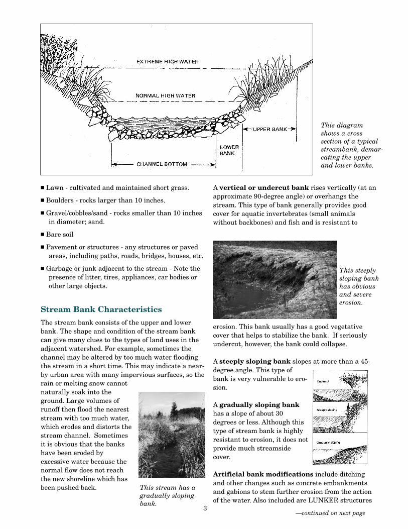
Lower Bank: The intermittently submerged portion of the bank from the normal water line to thehigh water line, or beginning of the upper bank (see page 3 diagram).
Upper Bank: The portion of the bank from the beginning of the high water line to the extreme highwater line (see page 3 diagram).
Time Needed:30 minutes
Equipment Needed:
— measuring tape
— markers/flags/ties for trees
— Habitat Check List
— watch with second hand/ stopwatch
— pen or pencil, clipboard
Volunteer MonitoringFactsheet Series
2006The Parts Equal the WholeHabitat Assessment:Habitat Assessment:
A stream with a healthy riparianzone.
Overview of Stream HabitatA healthy stream is a busy place. Wildlife find shelter and food nearand in its waters. Vegetation grows along its banks, shading thestream and filtering pollutants before they enter the stream. Withinthe stream itself are fish, insects and other tiny creatures with specificneeds: dissolved oxygen to breathe; rocks, overhanging tree limbs, logsand roots for shelter; vegetation and other tiny animals to eat; andspecial places to breed and hatch their young. For any of theseactivities, they might also need water of specific velocity, depth andtemperature. Many land-use activities can alter these characteristics,causing problems within the entire habitat.
When to Measure: Usually once a year in thesummer once leaves have emerged.
The Habitat Assessment is an easy-to-useapproach for identifying and assessing theelements of a stream’s habitat. It is based on
a simple protocol developed by the EnvironmentalProtection Agency, using observations of stream habitat characteristics and major physical attributes.Conducting an assessment is usually an annualevent, best performed in summer once leaves haveemerged. This assessment is useful as: 1) a screeningtool to identify habitat stressors and 2) a method forlearning about stream ecosystems and environmentalstewardship.
Taking stock of the habitat’s characteristics maybegin at the riparian zone where land is making atransition into water. Within healthy streamcorridors, this area generally has certain kinds of vegetation that acts as a buffer between land andwater, soaking up many runoff pollutants. Moving on,the stream assessment will then focus on thecondition of the upper and lower banks and finally thestream channel and stream itself. In order to helpprepare you to fill out the Habitat Check List, certainstream and river characteristics and concepts aredefined on the following pages.
Riparian Zone
The healthy riparian zone is characterized by trees,bushes, shrubs and tall grasses that help to buffer the
stream from polluted runoff and create habitat forfish and wildlife. These plants also provide streamshading (or overhead canopy) and serve severalimportant functions in the stream habitat. Thecanopy helps keep water temperatures cool byshading it from the sun, while offering protection andrefuge for animals.
Certain conditions in the riparian zone can negativelyaffect the stream’s habitat. Lawns maintained to thewater’s edge are abrupt transitions from land towater, offering very little or no buffering protectionfor the stream. In these cases, lawn care products andgrass clippings could be entering the stream. Short-grassed stream banks also provide poor habitat foranimals. Bare soil and pavement provide no bufferingaction from runoff.
Features to note in riparian zones:
■ Evergreen trees (conifers) - cone-bearing trees thatdo not lose their leaves in winter.
■ Hardwood trees (deciduous) - in general, trees thatshed their leaves at the end of the growing season.
■ Bushes - short conifers or deciduous shrubs lessthan 15 feet high.
■ Tall grass, ferns, etc. - includes tall, natural grasses,ferns, vines, and mosses.
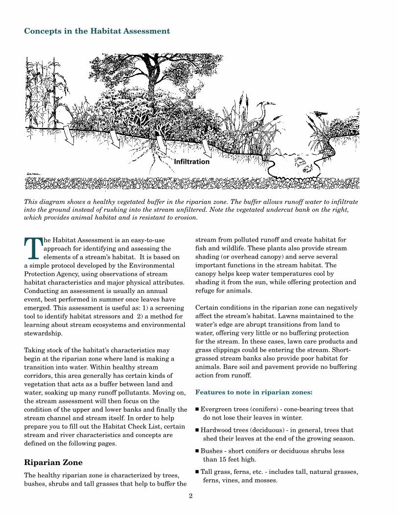
Concepts in the Habitat Assessment
This diagram shows a healthy vegetated buffer in the riparian zone. The buffer allows runoff water to infiltrateinto the ground instead of rushing into the stream unfiltered. Note the vegetated undercut bank on the right,which provides animal habitat and is resistant to erosion.
Infiltration
2
■ Lawn - cultivated and maintained short grass.
■ Boulders - rocks larger than 10 inches.
■ Gravel/cobbles/sand - rocks smaller than 10 inchesin diameter; sand.
■ Bare soil
■ Pavement or structures - any structures or pavedareas, including paths, roads, bridges, houses, etc.
■ Garbage or junk adjacent to the stream - Note thepresence of litter, tires, appliances, car bodies orother large objects.
Stream Bank Characteristics
The stream bank consists of the upper and lowerbank. The shape and condition of the stream bankcan give many clues to the types of land uses in theadjacent watershed. For example, sometimes thechannel may be altered by too much water floodingthe stream in a short time. This may indicate a near-by urban area with many impervious surfaces, so therain or melting snow cannotnaturally soak into theground. Large volumes ofrunoff then flood the neareststream with too much water,which erodes and distorts thestream channel. Sometimesit is obvious that the bankshave been eroded byexcessive water because thenormal flow does not reachthe new shoreline which hasbeen pushed back.
A vertical or undercut bank rises vertically (at anapproximate 90-degree angle) or overhangs thestream. This type of bank generally provides goodcover for aquatic invertebrates (small animalswithout backbones) and fish and is resistant to
erosion. This bank usually has a good vegetativecover that helps to stabilize the bank. If seriouslyundercut, however, the bank could collapse.
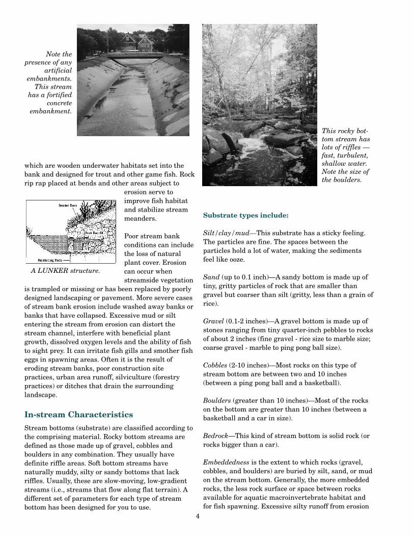
A steeply sloping bank slopes at more than a 45-degree angle. This type ofbank is very vulnerable to ero-sion.
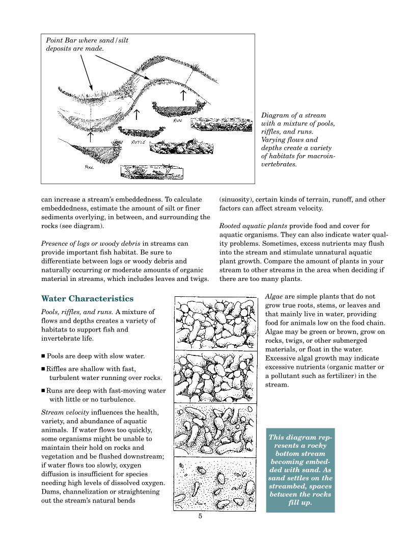
A gradually sloping bankhas a slope of about 30degrees or less. Although thistype of stream bank is highlyresistant to erosion, it does notprovide much streamsidecover.
Artificial bank modifications include ditchingand other changes such as concrete embankmentsand gabions to stem further erosion from the actionof the water. Also included are LUNKER structures
—continued on next page
This steeplysloping bankhas obviousand severeerosion.
This diagramshows a cross section of a typicalstreambank, demar-cating the upperand lower banks.
This stream has agradually slopingbank.
3
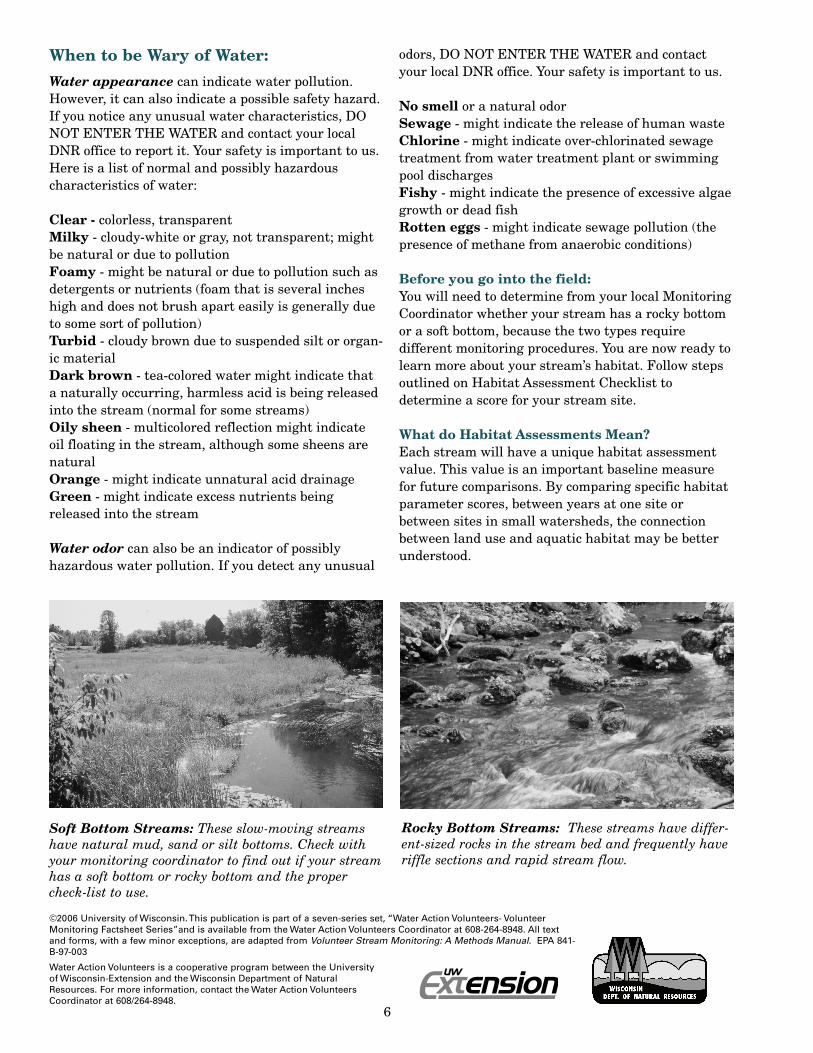
which are wooden underwater habitats set into thebank and designed for trout and other game fish. Rockrip rap placed at bends and other areas subject to
erosion serve toimprove fish habitatand stabilize streammeanders.
Poor stream bank conditions can includethe loss of naturalplant cover. Erosioncan occur whenstreamside vegetation
is trampled or missing or has been replaced by poorlydesigned landscaping or pavement. More severe casesof stream bank erosion include washed away banks orbanks that have collapsed. Excessive mud or siltentering the stream from erosion can distort thestream channel, interfere with beneficial plantgrowth, dissolved oxygen levels and the ability of fishto sight prey. It can irritate fish gills and smother fisheggs in spawning areas. Often it is the result oferoding stream banks, poor construction sitepractices, urban area runoff, silviculture (forestrypractices) or ditches that drain the surroundinglandscape.
In-stream Characteristics
Stream bottoms (substrate) are classified according tothe comprising material. Rocky bottom streams aredefined as those made up of gravel, cobbles andboulders in any combination. They usually havedefinite riffle areas. Soft bottom streams havenaturally muddy, silty or sandy bottoms that lackriffles. Usually, these are slow-moving, low-gradientstreams (i.e., streams that flow along flat terrain). Adifferent set of parameters for each type of streambottom has been designed for you to use.
Substrate types include:
Silt/clay/mud—This substrate has a sticky feeling.The particles are fine. The spaces between theparticles hold a lot of water, making the sedimentsfeel like ooze.
Sand (up to 0.1 inch)—A sandy bottom is made up oftiny, gritty particles of rock that are smaller thangravel but coarser than silt (gritty, less than a grain ofrice).
Gravel (0.1-2 inches)—A gravel bottom is made up ofstones ranging from tiny quarter-inch pebbles to rocksof about 2 inches (fine gravel - rice size to marble size;coarse gravel - marble to ping pong ball size).
Cobbles (2-10 inches)—Most rocks on this type ofstream bottom are between two and 10 inches(between a ping pong ball and a basketball).
Boulders (greater than 10 inches)—Most of the rockson the bottom are greater than 10 inches (between abasketball and a car in size).
Bedrock—This kind of stream bottom is solid rock (orrocks bigger than a car).
Embeddedness is the extent to which rocks (gravel,cobbles, and boulders) are buried by silt, sand, or mudon the stream bottom. Generally, the more embeddedrocks, the less rock surface or space between rocksavailable for aquatic macroinvertebrate habitat andfor fish spawning. Excessive silty runoff from erosion
Note the presence of any
artificialembankments.
This stream has a fortified
concreteembankment.
This rocky bot-tom stream haslots of riffles —fast, turbulent,shallow water.Note the size ofthe boulders.
A LUNKER structure.
4
can increase a stream’s embeddedness. To calculateembeddedness, estimate the amount of silt or finersediments overlying, in between, and surrounding therocks (see diagram).
Presence of logs or woody debris in streams canprovide important fish habitat. Be sure todifferentiate between logs or woody debris andnaturally occurring or moderate amounts of organicmaterial in streams, which includes leaves and twigs.
Water Characteristics
Pools, riffles, and runs. A mixture offlows and depths creates a variety ofhabitats to support fish andinvertebrate life.
■ Pools are deep with slow water.
■ Riffles are shallow with fast,turbulent water running over rocks.
■ Runs are deep with fast-moving waterwith little or no turbulence.
Stream velocity influences the health,variety, and abundance of aquaticanimals. If water flows too quickly,some organisms might be unable tomaintain their hold on rocks andvegetation and be flushed downstream;if water flows too slowly, oxygendiffusion is insufficient for speciesneeding high levels of dissolved oxygen.Dams, channelization or straighteningout the stream’s natural bends
(sinuosity), certain kinds of terrain, runoff, and otherfactors can affect stream velocity.
Rooted aquatic plants provide food and cover foraquatic organisms. They can also indicate water qual-ity problems. Sometimes, excess nutrients may flushinto the stream and stimulate unnatural aquaticplant growth. Compare the amount of plants in yourstream to other streams in the area when deciding ifthere are too many plants.
Algae are simple plants that do notgrow true roots, stems, or leaves andthat mainly live in water, providingfood for animals low on the food chain.Algae may be green or brown, grow onrocks, twigs, or other submergedmaterials, or float in the water.Excessive algal growth may indicateexcessive nutrients (organic matter ora pollutant such as fertilizer) in thestream.
This diagram rep-resents a rockybottom stream
becoming embed-ded with sand. Assand settles on thestreambed, spacesbetween the rocks
fill up.
Diagram of a streamwith a mixture of pools,riffles, and runs.Varying flows anddepths create a varietyof habitats for macroin-vertebrates.
Point Bar where sand/siltdeposits are made.
5
Water Action Volunteers is a cooperative program between the Universityof Wisconsin-Extension and the Wisconsin Department of NaturalResources. For more information, contact the Water Action VolunteersCoordinator at 608/264-8948.
Soft Bottom Streams: These slow-moving streamshave natural mud, sand or silt bottoms. Check withyour monitoring coordinator to find out if your streamhas a soft bottom or rocky bottom and the propercheck-list to use.
Rocky Bottom Streams: These streams have differ-ent-sized rocks in the stream bed and frequently haveriffle sections and rapid stream flow.
©2006 University of Wisconsin. This publication is part of a seven-series set, “Water Action Volunteers- VolunteerMonitoring Factsheet Series”and is available from the Water Action Volunteers Coordinator at 608-264-8948. All textand forms, with a few minor exceptions, are adapted from Volunteer Stream Monitoring: A Methods Manual. EPA 841-B-97-003
6
When to be Wary of Water:
Water appearance can indicate water pollution.However, it can also indicate a possible safety hazard.If you notice any unusual water characteristics, DONOT ENTER THE WATER and contact your localDNR office to report it. Your safety is important to us.Here is a list of normal and possibly hazardouscharacteristics of water:
Clear - colorless, transparentMilky - cloudy-white or gray, not transparent; mightbe natural or due to pollutionFoamy - might be natural or due to pollution such asdetergents or nutrients (foam that is several incheshigh and does not brush apart easily is generally dueto some sort of pollution)Turbid - cloudy brown due to suspended silt or organ-ic materialDark brown - tea-colored water might indicate thata naturally occurring, harmless acid is being releasedinto the stream (normal for some streams)Oily sheen - multicolored reflection might indicateoil floating in the stream, although some sheens arenaturalOrange - might indicate unnatural acid drainageGreen - might indicate excess nutrients beingreleased into the stream
Water odor can also be an indicator of possiblyhazardous water pollution. If you detect any unusual
odors, DO NOT ENTER THE WATER and contactyour local DNR office. Your safety is important to us.
No smell or a natural odorSewage - might indicate the release of human wasteChlorine - might indicate over-chlorinated sewagetreatment from water treatment plant or swimmingpool dischargesFishy - might indicate the presence of excessive algaegrowth or dead fishRotten eggs - might indicate sewage pollution (thepresence of methane from anaerobic conditions)
Before you go into the field:You will need to determine from your local MonitoringCoordinator whether your stream has a rocky bottomor a soft bottom, because the two types requiredifferent monitoring procedures. You are now ready tolearn more about your stream’s habitat. Follow stepsoutlined on Habitat Assessment Checklist todetermine a score for your stream site.
What do Habitat Assessments Mean?Each stream will have a unique habitat assessmentvalue. This value is an important baseline measurefor future comparisons. By comparing specific habitatparameter scores, between years at one site orbetween sites in small watersheds, the connectionbetween land use and aquatic habitat may be betterunderstood.