Embed Size (px)
Citation preview

Habitat Advisory Visit
River Whitewater, Hampshire
On behalf of Mr Richard Burt 8th September 2006
Sponsored By
2
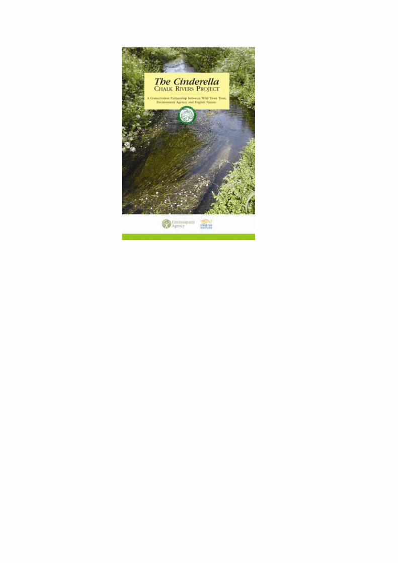
1.0 Introduction This report is the output of a site visit undertaken by the Wild Trout Trust on the River Whitewater within the Castle Mill House Estate, Hampshire on 8th September 2006. Comments in this report are based on observations on the day of the site visit and discussions with owner Mr Richard Burt and river keeper Shane ??? . Normal convention is applied throughout the report with respect to bank identification, i.e., the banks are designated left hand bank (LHB) or right hand bank (RHB) whilst looking downstream. 2.0 Overview The River Whitewater is a chalk stream and is a second order tributary of the River Thames The river has no statutory nature conservation designation and the WTT AV is funded by the Cinderella Chalk Rivers Project. The river adjoins the Greywell Fen calcareous valley mire Site of Special Scientific Interest (SSSI – see appendix 1) The project aims to initiate partnership projects to improve the conservation status of the less well known, but equally important chalk rivers, which have been termed ‘The Cinderella’s’ (See enclosed leaflet) The Whitewater can be best described as a typical example of modified lowland chalk river. Over many decades the river has been subjected to over-zealous flood defence works, the installation of mill and weir structures and appears to be suffering from the effects of poor rainfall (drought) and possible over-abstraction. In broad terms it would appear this reach of the river is currently failing to provide the mosaic of habitat types wild trout need to fulfil their ‘life-cycle requirements’ (Fig 1) This also has impacts on the myriad of other species (some of European importance, e.g. water vole, bullhead and brook lamprey) that also rely on a range of diverse habitat types.
Eyed ova Fry
Parr Adult
3

Fig 1) The wild trout’s ‘life-cycle’ habitat requirements Despite these impacts there are areas of adequate habitat to use as a foundation t work towards the goal creating a self-sustaining population of wild trout. The Whitewater catchment is known to be stocked throughout it’s length with domesticated diploid (fertile) brown trout. The Castle Mill House reach stocks with both adult and fingerling diploid brown trout. Adult browns are hand fed with pellet before being released periodically into the reach upstream of the mill. Environment Agency (EA) Fisheries Officers confirm the presence of wild fish in the catchment albeit in small numbers. The EA class the river as a native trout water, allowing stocking within certain parameters. Of particular concern is the confirmed presence of the American Signal Crayfish an alien species, which is known to have disastrous impacts on populations of native White-clawed crayfish. It should be noted that it is a legal requirement that introductions of fish, fry and ova require written EA consent prior to stocking. The problems listed above are not unique to the Whitewater and are common to many chalk rivers in England. The potential scale and cost of actions to enhance and restore habitat can seem a daunting task. The owner Mr Richard Burt wishes to restore the natural heritage of the river and fishery in his care. Since acquiring the estate Mr Burt and his river keeper have undertaken a programme of small-scale enhancements and annual maintenance tasks in order to improve the fishing. A WTT AV has been requested with a view to undertaking a more ambitious restoration project. Many of the recommendations in this report are detailed in the WTT’s new Wild Trout Survival Guide (WTSG), a copy of which was supplied during the visit. Relevant sections of the WTSG will be highlighted as footnotes.
4
3.0 – Site Visit and Recommendations Broadly speaking the visit was broadly split into two reaches:
1) Downstream of Deptford Bridge to the Basingstoke Canal culvert 2) U/s Castle Mill House to the Basingstoke Canal
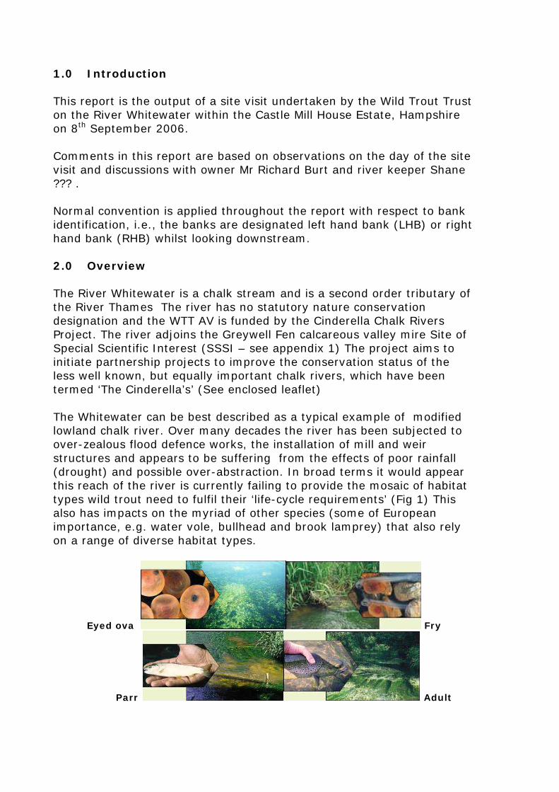
3.1 D/s Deptford Bridge The river here appears to be suffering from the effects of low flows . Filamentous algae covers most of the bed of the river with very little remaining in the way macrophyte growth (e.g. Starwort). The low flow velocity is exacerbated further due to the presence of a weir structure 50m d/s of the bridge.
The Whitewater d/s Deptford Bridge (note 100% algal coverage)
5
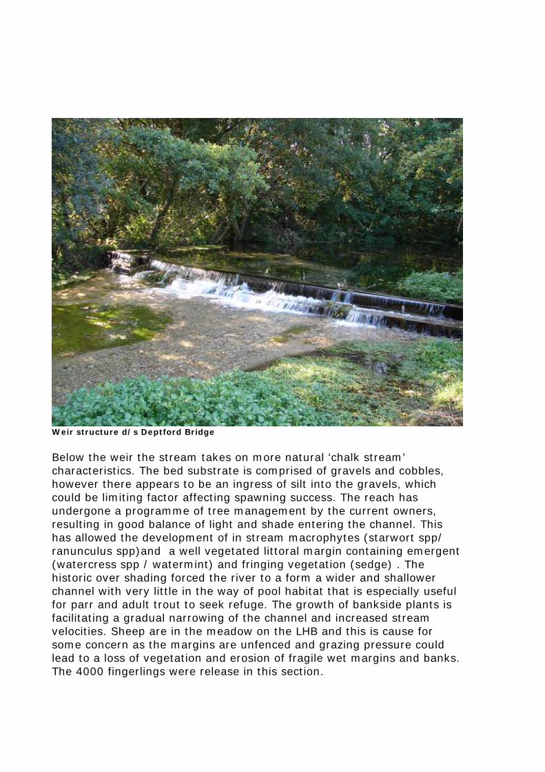
Weir structure d/s Deptford Bridge
Below the weir the stream takes on more natural ‘chalk stream’ characteristics. The bed substrate is comprised of gravels and cobbles, however there appears to be an ingress of silt into the gravels, which could be limiting factor affecting spawning success. The reach has undergone a programme of tree management by the current owners, resulting in good balance of light and shade entering the channel. This has allowed the development of in stream macrophytes (starwort spp/ ranunculus spp)and a well vegetated littoral margin containing emergent (watercress spp / watermint) and fringing vegetation (sedge) . The historic over shading forced the river to a form a wider and shallower channel with very little in the way of pool habitat that is especially useful for parr and adult trout to seek refuge. The growth of bankside plants is facilitating a gradual narrowing of the channel and increased stream velocities. Sheep are in the meadow on the LHB and this is cause for some concern as the margins are unfenced and grazing pressure could lead to a loss of vegetation and erosion of fragile wet margins and banks. The 4000 fingerlings were release in this section.
6
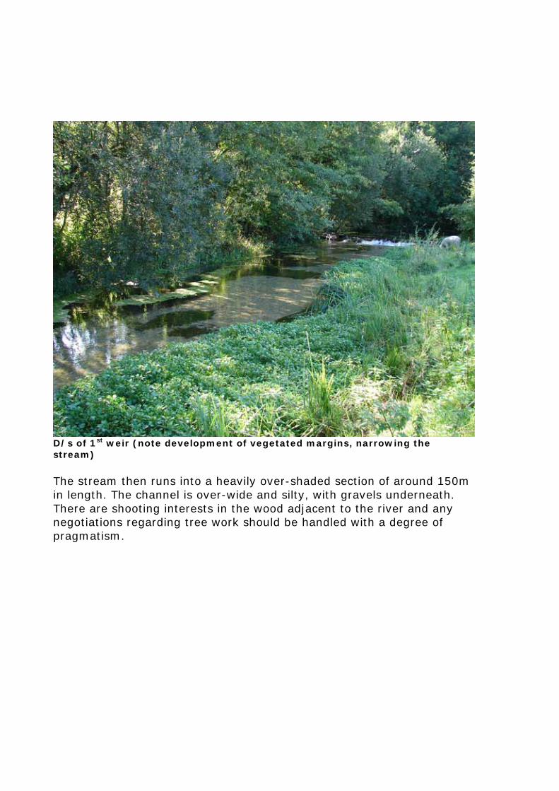
D/s of 1st weir (note development of vegetated margins, narrowing the stream) The stream then runs into a heavily over-shaded section of around 150m in length. The channel is over-wide and silty, with gravels underneath. There are shooting interests in the wood adjacent to the river and any negotiations regarding tree work should be handled with a degree of pragmatism.
7
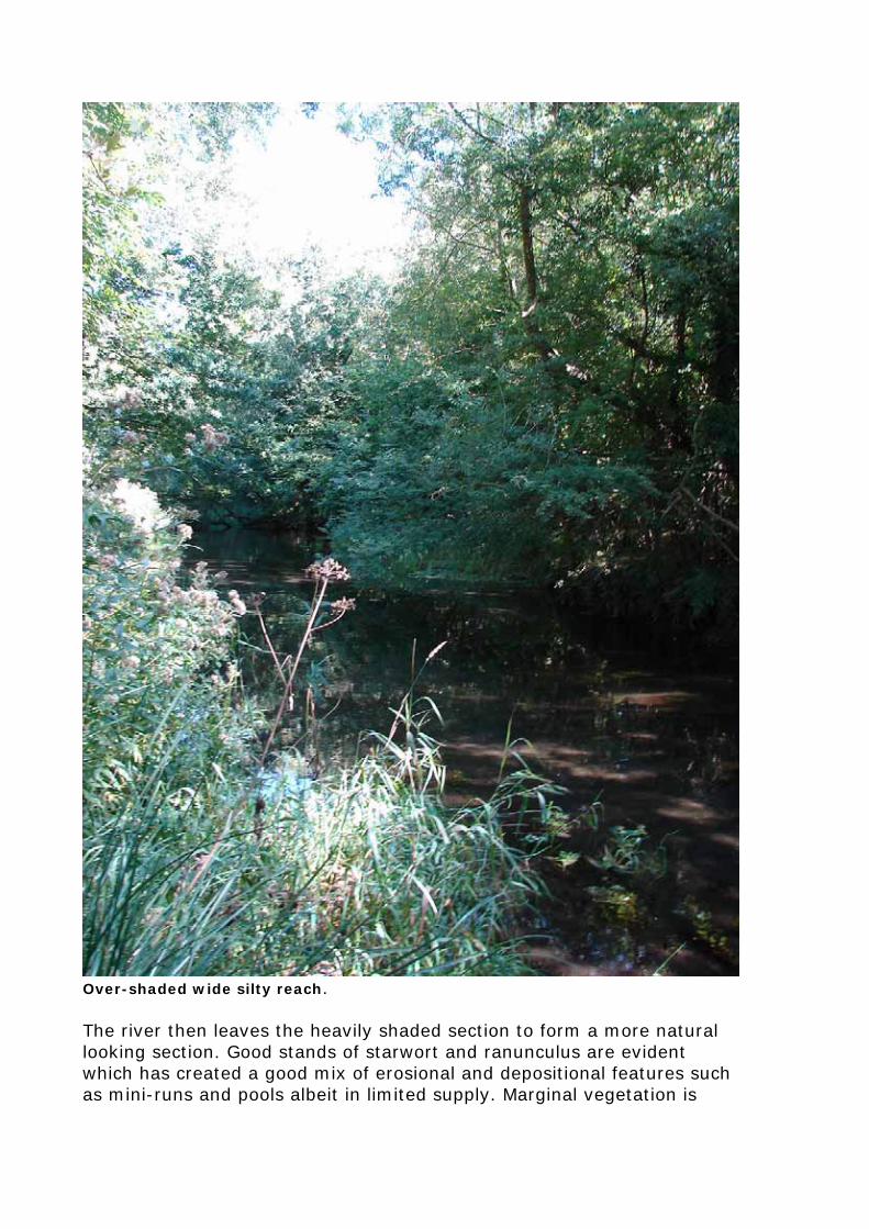
Over-shaded wide silty reach. The river then leaves the heavily shaded section to form a more natural looking section. Good stands of starwort and ranunculus are evident which has created a good mix of erosional and depositional features such as mini-runs and pools albeit in limited supply. Marginal vegetation is
8
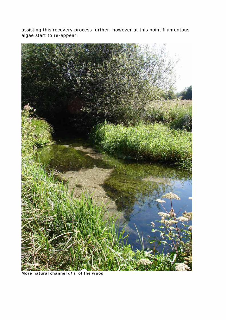
assisting this recovery process further, however at this point filamentous algae start to re-appear.
More natural channel d/s of the wood
9
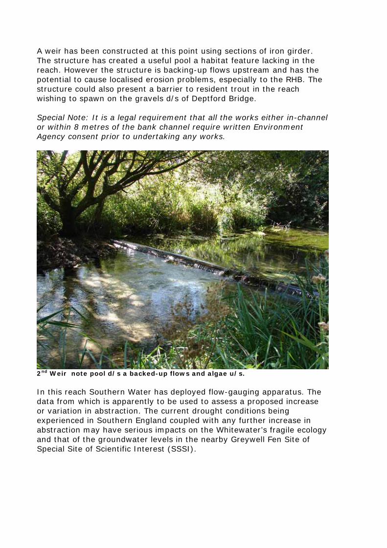
A weir has been constructed at this point using sections of iron girder. The structure has created a useful pool a habitat feature lacking in the reach. However the structure is backing-up flows upstream and has the potential to cause localised erosion problems, especially to the RHB. The structure could also present a barrier to resident trout in the reach wishing to spawn on the gravels d/s of Deptford Bridge. Special Note: It is a legal requirement that all the works either in-channel or within 8 metres of the bank channel require written Environment Agency consent prior to undertaking any works.
2nd Weir note pool d/s a backed-up flows and algae u/s. In this reach Southern Water has deployed flow-gauging apparatus. The data from which is apparently to be used to assess a proposed increase or variation in abstraction. The current drought conditions being experienced in Southern England coupled with any further increase in abstraction may have serious impacts on the Whitewater’s fragile ecology and that of the groundwater levels in the nearby Greywell Fen Site of Special Site of Scientific Interest (SSSI).
10
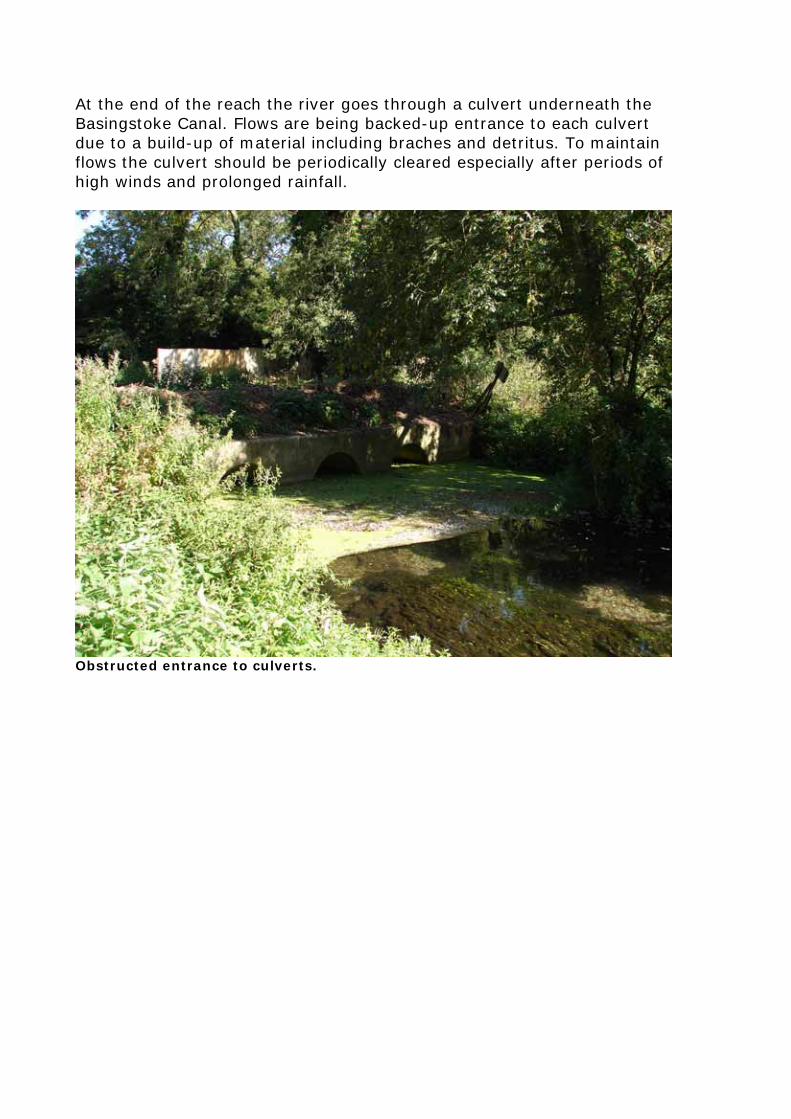
At the end of the reach the river goes through a culvert underneath the Basingstoke Canal. Flows are being backed-up entrance to each culvert due to a build-up of material including braches and detritus. To maintain flows the culvert should be periodically cleared especially after periods of high winds and prolonged rainfall.
Obstructed entrance to culverts.
11
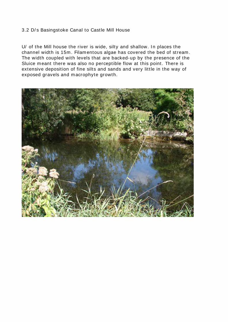
3.2 D/s Basingstoke Canal to Castle Mill House U/ of the Mill house the river is wide, silty and shallow. In places the channel width is 15m. Filamentous algae has covered the bed of stream. The width coupled with levels that are backed-up by the presence of the Sluice meant there was also no perceptible flow at this point. There is extensive deposition of fine silts and sands and very little in the way of exposed gravels and macrophyte growth.
12
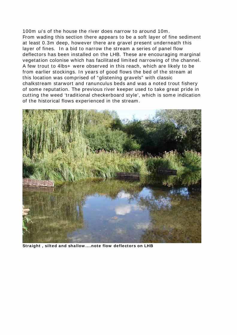
100m u/s of the house the river does narrow to around 10m. From wading this section there appears to be a soft layer of fine sediment at least 0.3m deep, however there are gravel present underneath this layer of fines. In a bid to narrow the stream a series of panel flow deflectors has been installed on the LHB. These are encouraging marginal vegetation colonise which has facilitated limited narrowing of the channel. A few trout to 4lbs+ were observed in this reach, which are likely to be from earlier stockings. In years of good flows the bed of the stream at this location was comprised of “glistening gravels” with classic chalkstream starwort and ranunculus beds and was a noted trout fishery of some reputation. The previous river keeper used to take great pride in cutting the weed ‘traditional checkerboard style’, which is some indication of the historical flows experienced in the stream.
Straight , silted and shallow....note flow deflectors on LHB
13
4.0 – Recommendations It is a legal requirement that all the works to the river written Environment Agency consent prior to undertaking any works, either in-channel or within 8 metres of the bank. Local EA Fisheries, Recreation and Biodiversity and Development Control staff should be contacted at the earliest opportunity to discuss any recommendations arising from this report the estate may wish to pursue. 4.1) Reach 1 - Downstream of Deptford Bridge to the Basingstoke Canal In the field on the RHB immediately downstream of Deptford Bridge it is recommended to install a stock proof fence with sheep netting to prtect the fragile nature of the riverbank plant community. The stream in this section is over-wide (approx 7m). There are sections where channel width narrows to around 4m and stream velocities improve and exposed gravels are present. It is these sections that provide a good template for restoration works d/s. In over-wide sections a new bank line should be created using brushwood faggots staked along the RHB1. At various points it is also recommended that flows be ‘pinched’ by installing paired and single faggot deflectors to allow the river to scour pool habitat2. Chalk should be used as suitable backfill for these features. The new bank should be set no more than 10cm above summer water level to allow the development of emergent wetland plants such as sedge, water forget-me-not, brooklime, yellow flag-iris and water mint, etc. Consideration should be given to transplanting well-established emergent vegetation from adjacent areas to facilitate the colonisation process. A density of four plants per square metre should achieve rapid results. This habitat is particularly important for grey wagtails, reed warblers, southern damselfly and water voles, (which are known to forage along wet vegetated berms). Fringing vegetation will also provide cover for trout fry on emergence from spawning gravels. Woody debris3 in rivers can provide habitat for a variety of animals. Brown trout numbers increase significantly with the presence of woody debris along the banks and in the river as they provide refuge and cover. They may offer lies for otters or perches for kingfishers. Woody debris in the river may also create pools and riffles in sections of the river that would otherwise have a dearth of aquatic habitats. They also retain leaf litter and act as an energy reservoir for the river section.
1 See WTSG page 42 2 See WTSG page 44 3 See WTSG page 39
14
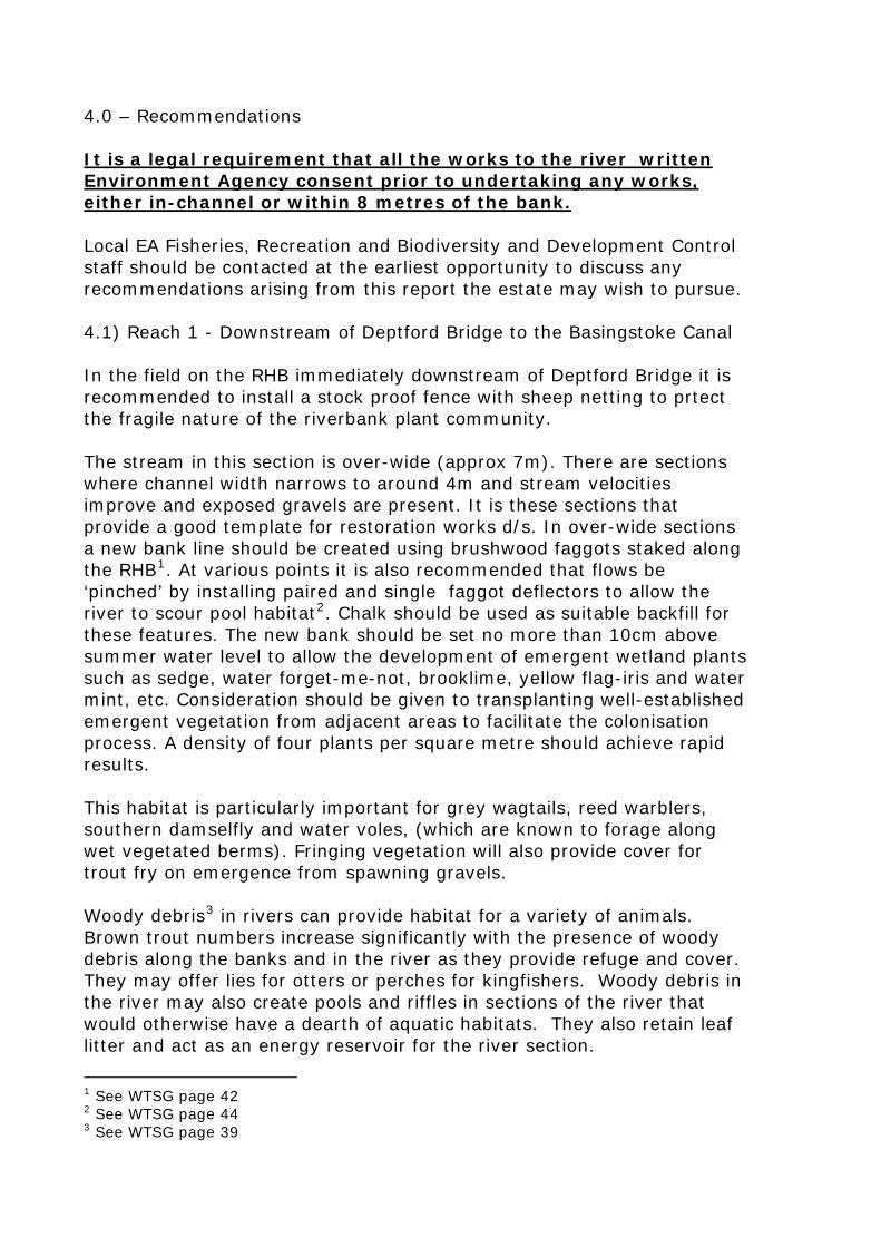
Fallen timber can be used to create flow deflectors. Deflectors need to be; 1) keyed into the bank to avoid localised erosion and; 2) staked and wired to the bed of the river to avoid being washed-away. During winter flows the deflectors will scour out pools and naturally sort and clean gravels suitable for trout spawning. As a very rough guide deflectors should be set at approximately 30 degrees to the bank with a length of between 40-50% of channel width, or staked in mid channel as paired submerged upstream facing logs. Deflectors keyed in from the bank should be just at summer water level Scour pools have been shown to be very important habitat for all life stages of brown trout. Deflectors could be particularly useful if placed silted riffle areas.
15
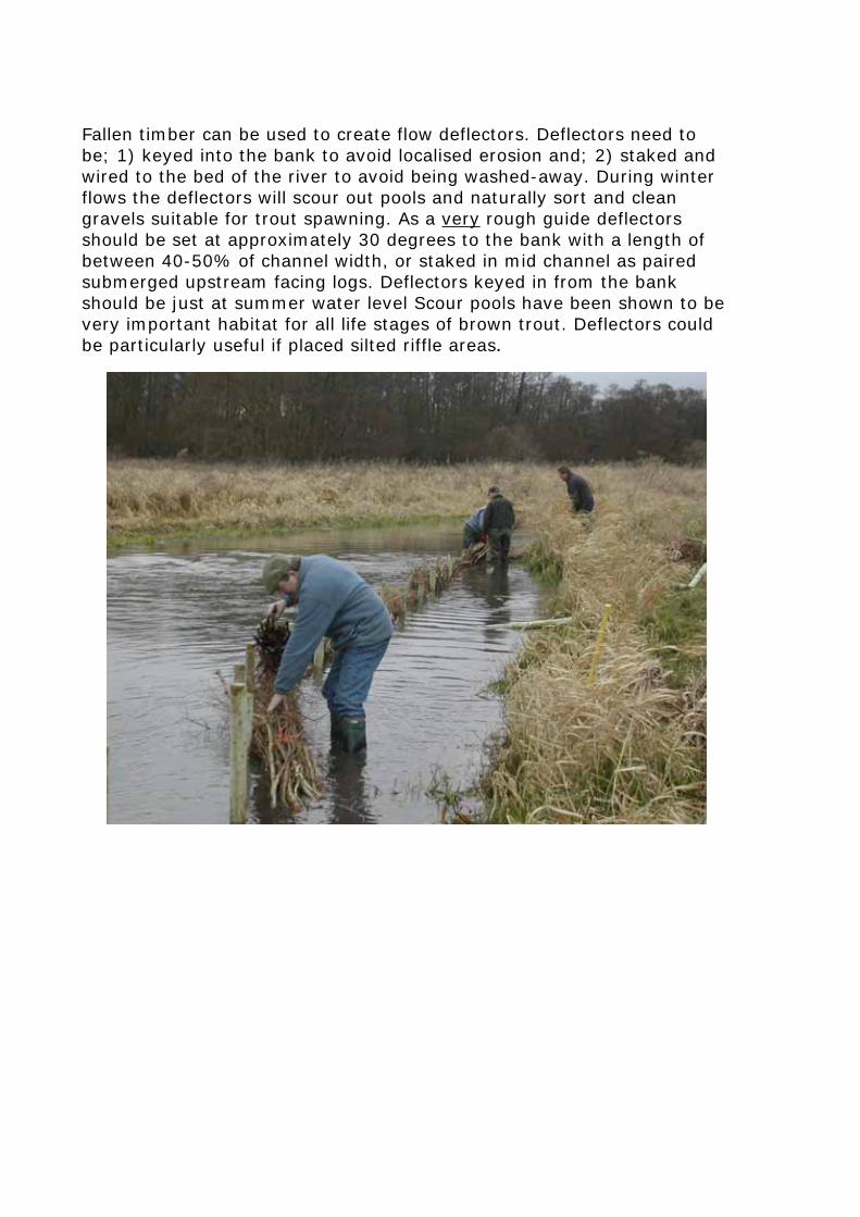
Installation of new bank using faggots and chalk backfill on the River Wensum, Norfolk
16
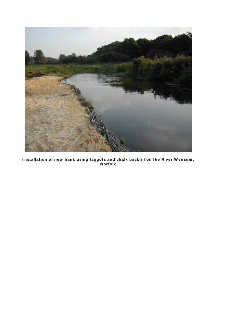
Introduction of single u/s ‘natural’ deflectors (single, near bank and triangular’
far bank) on the Wylye in Wiltshire formed a chicane, sending flow from one bank to another. Note set just above summer water levels.
17
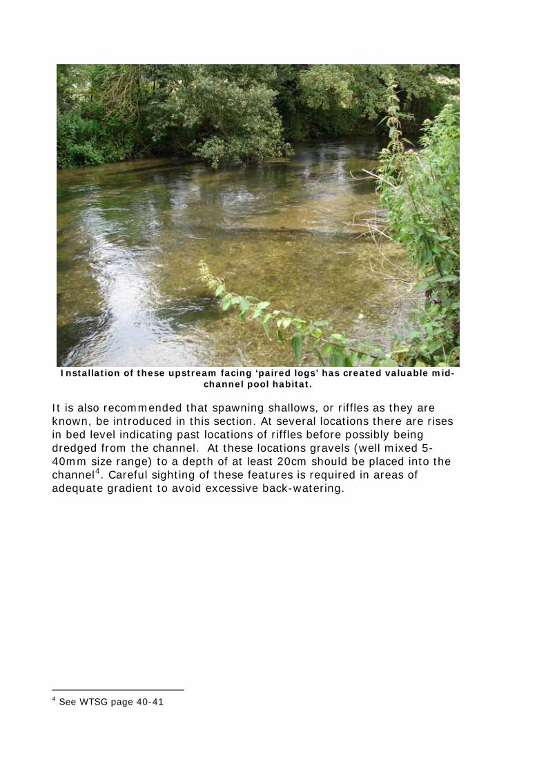
Installation of these upstream facing ‘paired logs’ has created valuable mid-
channel pool habitat. It is also recommended that spawning shallows, or riffles as they are known, be introduced in this section. At several locations there are rises in bed level indicating past locations of riffles before possibly being dredged from the channel. At these locations gravels (well mixed 5-40mm size range) to a depth of at least 20cm should be placed into the channel4. Careful sighting of these features is required in areas of adequate gradient to avoid excessive back-watering.
4 See WTSG page 40-41
18
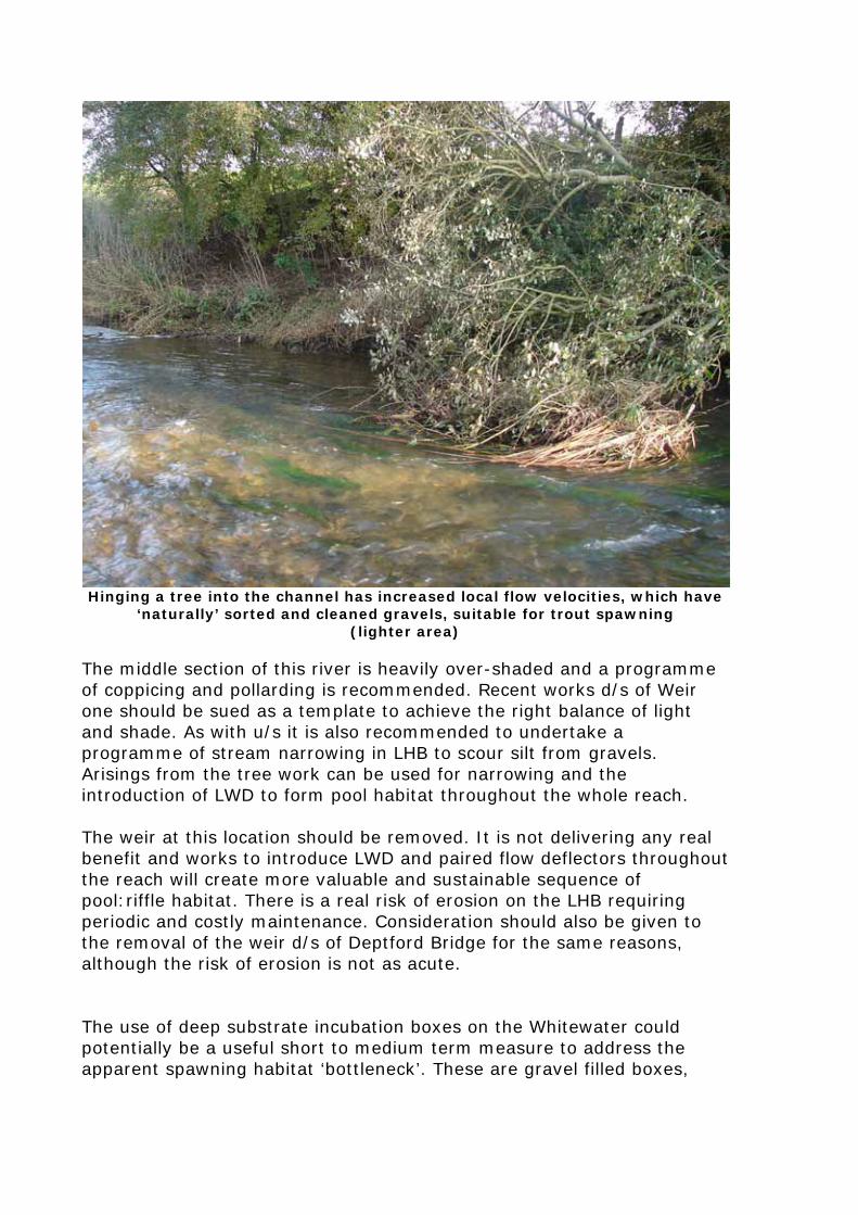
Hinging a tree into the channel has increased local flow velocities, which have
‘naturally’ sorted and cleaned gravels, suitable for trout spawning (lighter area)
The middle section of this river is heavily over-shaded and a programme of coppicing and pollarding is recommended. Recent works d/s of Weir one should be sued as a template to achieve the right balance of light and shade. As with u/s it is also recommended to undertake a programme of stream narrowing in LHB to scour silt from gravels. Arisings from the tree work can be used for narrowing and the introduction of LWD to form pool habitat throughout the whole reach. The weir at this location should be removed. It is not delivering any real benefit and works to introduce LWD and paired flow deflectors throughout the reach will create more valuable and sustainable sequence of pool:riffle habitat. There is a real risk of erosion on the LHB requiring periodic and costly maintenance. Consideration should also be given to the removal of the weir d/s of Deptford Bridge for the same reasons, although the risk of erosion is not as acute. The use of deep substrate incubation boxes on the Whitewater could potentially be a useful short to medium term measure to address the apparent spawning habitat ‘bottleneck’. These are gravel filled boxes,
19
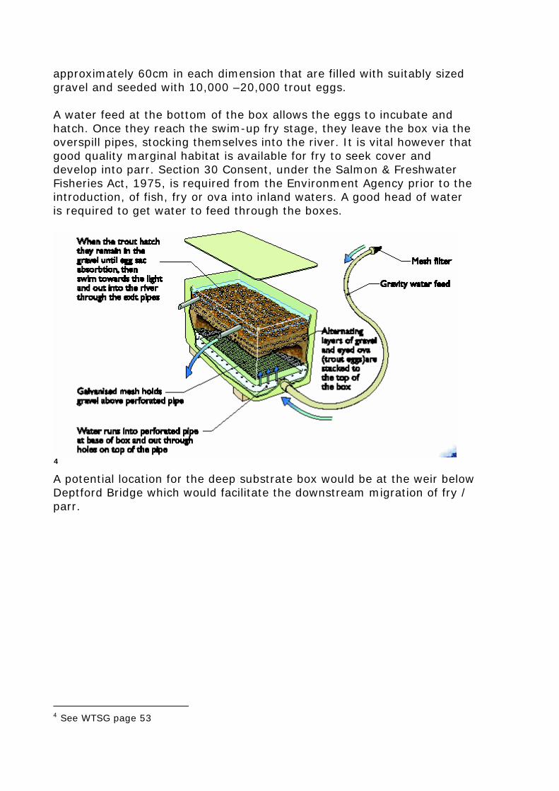
approximately 60cm in each dimension that are filled with suitably sized gravel and seeded with 10,000 –20,000 trout eggs. A water feed at the bottom of the box allows the eggs to incubate and hatch. Once they reach the swim-up fry stage, they leave the box via the overspill pipes, stocking themselves into the river. It is vital however that good quality marginal habitat is available for fry to seek cover and develop into parr. Section 30 Consent, under the Salmon & Freshwater Fisheries Act, 1975, is required from the Environment Agency prior to the introduction, of fish, fry or ova into inland waters. A good head of water is required to get water to feed through the boxes.
4
A potential location for the deep substrate box would be at the weir below Deptford Bridge which would facilitate the downstream migration of fry / parr.
4 See WTSG page 53
20
4.2 – Reach 2 - U/s Castle Mill House to the Basingstoke Canal The approach to address habitat improvement of this reach requires a differing scale of approach to that upstream. Downstream for approximately 100m from the canal culvert it is recommended that a programme of significant narrowing (5m+) be undertaken. This could be either narrow from the RHB or perhaps the installation of mid-channel brushwood islands.5
Both prescriptions should be installed to just above mean summer water levels to allow them to drown out at high winter flows. Some consideration needs to be given to the fact that the river is experiencing drought conditions and this will need to be factored into any design works. The net effect of both features will be to increase flow velocity and depth to create a deeper flowing channel with an exposed gravel substrate, promoting the growth of starwort and ranunculus spp. The mill structure may be having a significant impact on flow velocities within the reach. Consideration should be given to the manipulation of water levels by lowering the sluice gates to increase flow velocity. This option needs to discussed in detail with the Environment Agency and Natural England who will have views on the Water Resource implications and possible impacts on ground water levels in Greywell Fen. A possible option here would be to install a gravel riffle downstream of Greywell Fen to maintain water groundwater levels. Options for the area of the stream in the immediate 50-100 m u/s of the sluice should be left until decisions have been made about manipulation water levels and stream velocities. Traditionally these areas were wide and deep to allow the build-up of a head of water overnight to power the mill the next morning. 5 See WTSG page 41-46
21
4.0 – What next? – Making it all happen! This report makes a series of recommendations that will improve both the biodiversity and status of the wild trout populations in both rivers. Recommendations range from low tech, low cost and can hopefully be undertaken by the river keeper and assistants through to larger scale and more costly options requiring the use of specialist consultants and contractors. This report represents phase 1 of a potential 4 phase package of WTT assistance. At this point it is worth discussing restoration plans with suitably qualified to contractor to get ball park figure project costs, before requesting Phase 2, a worked-up WTT project proposal. However before this happens it strongly recommended that contact be made with the Fisheries/ Biodiversity and Development Control functions of the local Environment Agency to arrange a ‘pre-application meeting’. Pre-application meetings are extremely useful to help scope out design work and to take into consideration any issues that could affect proposed works. At this point local Natural England staff should be invited to any pre-application meetings. The worked-up proposal should provide all the necessary information for the completion of a land drainage consent application. This legal consent from the Environment Agency must be obtained in writing before works can commence. Consents can take up to two months to process. It is proposed that the WTT, or its representative, attends the pre-application meeting before commencing a detailed project specification / proposal On successful completion of phase two of the project an application can be made (Phase three), for seed-corn funding to kick start the project. Typically this is between £1000-2000. Physical works could be yet further ‘kick-started’ with the assistance of a WTT ‘Practical Visit’ (PV) (Phase 4). The WTT will fund the cost of labour (two man team) and materials. Recipients will be expected to cover travel and accommodation expenses of the contractor. The use of specialist plant will be by separate negotiation. The PV would be particularly suited to works u/s of the canal culvert.
22
Wet-work advisers will demonstrate one or more of the following techniques that are appropriate to the site.
• Tree management (coppice, pollard, sky-lighting) • Tree Planting • Fencing (Installation & Repair) • Stream Narrowing (Faggots, Coir Rolls, Spilling) • Flow Deflectors • Introduction of spawning substrate • Gravel Jetting • Introduction / Management of Woody Debris
Note: Recipients of the programme must have received a WTT AV and have obtained the appropriate consents from the Environment Agency, English Nature, ,etc, prior to arrangements being made to undertake the PV.
Applications for all the above should be made via [email protected] or [email protected]. 6.0 Disclaimer This report is produced for guidance only and should not be used as a substitute for full professional advice. Accordingly, no liability or responsibility for any loss or damage can be accepted by the Wild Trout Trust as a result of any other person, company or organisation acting, or refraining from acting, upon comments made in this report.
23
Appendix 1 County: Hampshire Site Name: Greywell Fen SSSI Local Planning Authority: Hampshire County Council, Hart District Council National Grid Reference: SU 719509 Ordnance Survey Sheet 1:50,000: 1 8 6 1:25,000: SU 75 Area: 29.19 (ha) 72.13 (ac) Date Notified (Under 1949 Act): 1 9 5 1 Date of Last Revision: 1 9 7 8 Date Notified (Under 1981 Act): 1 9 8 4 Date of Last Revision: – Other Information: Reasons for Notification: Greywell Fen is a calcareous valley mire extending for about 2km along the headwaters of the River Whitewater, a second order tributary of the River Thames. The vegetation of the fen falls into two distinct sections. Upstream from Deptford Bridge, the fen is primarily unmanaged agriculturally and is dominated by alder carr with tussock sedge Carex paniculata below. In a few small areas the canopy has remained open and these patches contain a very rich flora with a wide range of rich-fen species, including various sedges such as Carex diandra and C . lepidocarpa, a rare hybrid marsh orchid Dactylorhiza traunsteineri 3 praetermissa, marsh helleborine Epipactis palustris, broad-leaved cottongrass E r i o p h o r u m latifolium, water avens Geum rivale, marsh arrowgrass Triglochin palustris, marsh valerian Valeriana dioica and marsh fern Thelypteris thelypteroides. Other rare species formerly recorded, such as great fen-sedge Cladium mariscus and slender cottongrass Eriophorum gracile, appear to have been lost through competition with more vigorous vegetation. The lower section of the site is best described as wet fen meadow, grazed by cattle, with the exception of an area of carr woodland along the side of the Basingstoke Canal. Parts of this lower section have been agriculturally improved in recent years and their flora has been much reduced in diversity overall. Collectively, however, there is still a very rich flora, including most fen species, together with meadow species such as cowslip Primula veris, dyer’s greenweed Genista tinctoria and pepper-saxifrage Silaum silaus. One small area supports colonies of an unusual variant marsh helleborine Epipactis palustris var. o c h r o l e n c a and the fen subspecies of fragrant orchid Gymnadenia conopsea var. densiflora.
24