Embed Size (px)
Citation preview
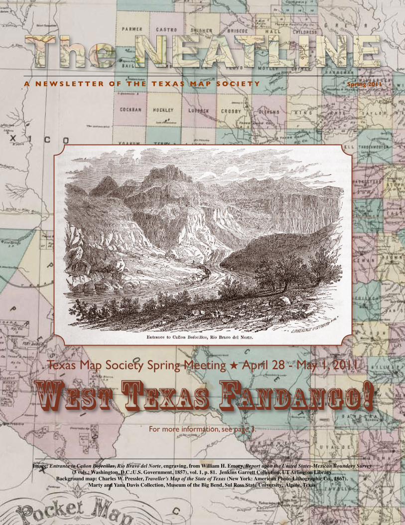
A N E W S L E T T E R O F T H E T E X A S M A P S O C I E T Y Spring 2011
Image: Entrance to Cañon Bofecillas, Rio Bravo del Norte, engraving, from William H. Emory, Report upon the United States-Mexican Boundary Survey (3 vols.; Washington, D.C.:U.S. Government, 1857), vol. 1, p. 81. Jenkins Garrett Collection, UT Arlington Library
Background map: Charles W. Pressler, Traveller’s Map of the State of Texas (New York: American Photo-Lithographic Co., 1867). Marty and Yana Davis Collection, Museum of the Big Bend, Sul Ross State University, Alpine, Texas
West texas Fandango!Texas Map Society Spring Meeting h April 28 - May 1, 2011
For more information, see page 3.

2 • The Neatline
FROM THE PRESIdENTPreliminary to beginning my term as the Society’s
next president, I reviewed our charter and mission accomplishments so far. Although only a decade old, we have achieved much toward the goals set by the founding members. Programs have continued to inform and entertain, while establishing a fraternal bond among members. Past leadership moved toward ever improving administration and an efficient balance of good organization and friendly responsiveness.
Challenges ahead include enhanced membership, more participation from public custodians of Texas map collections, extension of semi-annual education programs to more teachers and students of history, geography and political science, in both high school and universities, and examination of methods to create an easily viewable inventory of significant Texas maps held by institutions. I extend an invitation for volunteers, ideas and insight on how to achieve any or all of the above.
Next month, we are ready for our return session to the Trans-Pecos, Big Bend and the Davis Mountains. The spring meeting will feature an “early bird” Thursday night dinner at Casa Davis, followed the next day by an afternoon escorted field trip by the Center for Big Bend Studies to an active archeological site. That evening will be a viewing of the traveling exhibit Going to Texas: Five Hundred Years of Texas Maps and a tour of the exhibits at the Museum of the Big Bend, with eats and drinks. After the activities of the day-long Saturday program (see Ben’s article in this issue for details), we all are invited to a dinner at the Sproul Ranch, situated behind Prude Ranch and below the McDonald Observatory. The weekend will conclude on Sunday with a cowboy campfire breakfast at historic Fort Davis, with a tour of the National Historic Site.
Register early and get your accommodations now, because this is a resort area. And bring friends and a new member or two! See you all “west of the Pecos”.–Marty Davis, TMS President 2010-2012
The Neatline is published semi-annually by the Texas Map Societyc/o Special Collections - The University of Texas at Arlington LibraryBox 19497 - 902 Planetarium Place - Arlington, TX 76019-0497http://www.TexasMapSociety.org
For more information contact David Finfrock - Editor, Texas Map Society.Phone: 972.299.6454 - Email: [email protected]
Texas Map Society members who helped produce this issue are: Marty Davis, Imre Demhardt, David Finfrock, Shari Finfrock, Max Gross, Ben Huseman, Mark Lambert, Dianne Powell, Bob Rodriguez, Lynne Starnes, Peter van der Krogt, Matt Walter, Walt Wilson and our artist and graphic designer Carol Lehman.
A Neatline is the outermost drawn line surrounding a map. It defines the height and width of the map and usually constrains the cartographic images.
FROM THE EdITORFor those who attended the fall TMS meeting in
Arlington, you may remember me announcing that my employer, KXAS-TV NBC5 in Dallas-Fort Worth would be shooting a promotional video in the Special Collections at the UTA library. Thanks to the generosity of Ann Hodges and Ben Huseman, the promo was shot, and has been running on the air in the Metroplex for the last couple of months. If you live outside of North Texas and would like to see it, you can go to: http://www.nbcdfw.com/station/as-seen-on/Get_More_Local__David_Finfrock_s_Maps_Dallas-Fort_Worth-116336439.html
After a successful Fall 2010 meeting in Arlington, and an upcoming Spring 2011 meeting in Fort Davis (both are reviewed or previewed in this newsletter) the Texas Map Society is now thinking even farther ahead. In 2012, we will have our regular Fall meeting in Arlington. But the Spring 2012 meeting will be postponed a few months and take place in the summer instead.
For the first time, the Texas Map Society will team up with the Rocky Mountain Map Society to present The Mapping of North America: Westward Expansion. Other sponsors include the Denver Public Library, and the University of Denver. The meeting will take place 26-27 July 2012 at the University of Denver. That will be followed by another two day event: The Map Fair of the West, on 28-29 July 2012, which will be at The Denver Public Library. Ben Huseman tells us that he has heard rumors that the California Map Society may take part as well.
Here is a link to the home page of the web site of the Rocky Mountain Map Society: http://lamar.colostate.edu/~mcole/
The following link provides more information, including the exciting list of confirmed speakers, including our own Dr. Imre Demhardt: http://lamar.colostate.edu/~mcole/2012_Conference.pdf
So be sure to set aside time in late July 2012 for an exciting four day map extravaganza.
The TMS Board of Directors has voted to continue printing paper copies of each issue of The Neatline. So you will continue to receive those. But be aware that while the paper version is usually restricted to only 8 pages for each edition, the online version has no such restrictions. So by checking the electronic version, you may find some articles in longer, unedited versions, and more photographs to go along with the articles. So check out the web version, even if you have a paper copy.
And remember that even more information on the Texas Map Society can be found at our website at: http://www.TexasMapSociety.org. – David Finfrock
3 • The Neatline
The Annual Spring Meeting of the Texas Map Society will be held in Alpine and Fort Davis from Thursday, April 28, through Sunday, May 1. A Thursday-night dinner for speakers and early arrivals at Casa Davis in Fort Davis kicks off the four-day event. Attendees may check-in and receive their meeting materials anytime on Friday between 9:00 a.m. and 4:00 p.m. at the boardroom of the Museum of the Big Bend, located in the northeast quadrant of the campus of Sul Ross State University in Alpine. A special guided archaeological field trip for TMS members sponsored by SRSU’s Center for Big Bend Studies leaves at 1:00 p.m. from the parking lot north of the museum. With hundreds of possible sites available but not generally promoted or advertised to the public in this historic area, the tour should prove quite interesting for those privileged to attend. That evening the staff members of the Museum of the Big Bend will host a reception for TMS members, who will be given guided tours of the facility and several exhibits, including “Going to Texas: Five Centuries of Texas Maps.” This is the magnificent exhibit that has toured the state for the past two years, drawn entirely from the Marty and Yana Davis Map Collection of the Museum of the Big Bend and accompanied by a catalog published by the TCU Press in Fort Worth. The maps in this stunning exhibit – all beautifully matted and framed – should not be missed by anyone with an interest in maps and in Texas, and those of us who have already seen the exhibit even several times at different venues will welcome this marvelous opportunity to see them all once again, this time in their beautiful permanent home. (Some TMS members may recall that in the last official TMS visit to Alpine in Spring 2006 the Museum’s new facilities were still under construction.)
The Saturday TMS Spring 2011 meeting presentation sessions will be held at the Vic and Mary Jane Morgan University Center, located just across from the Museum of the Big Bend on the Sul Ross State University campus. After a light continental breakfast at 8:00 a.m., the sessions officially begin at 9:00 a.m. Matt Walter, Curator of Cartographic Collections and Historian, Museum of the Big Bend will present “Putting Texas on the Map” and Paul Wright, Professor of Geography and Sociology, Sul Ross State University, will speak on “Changing Big Bend Boundaries as Portrayed in Contemporary Maps, 1850-1930.” Lunch will be served and TMS members receive a special treat as Joaquin Walker, Retired Texas Ranger Captain and Author of One Ranger addresses the group and recounts some of his own real-life adventures. That afternoon, Andy Cloud, Director, Center for Big Bend Studies, Sul Ross State University, will speak on “Archaeological Mapping: Traditional and New Innovative Approaches.” Then Gerald Saxon, Dean of the Library and Professor of History, UT Arlington, presents “The Texan Santa Fe Expedition: Disaster for Want of a Map.”
TMS members can then look forward to a delightful evening of good food and fellowship at Sproul Ranch. A Sunday morning “Cowboy Campfire Breakfast” and tour at Fort Davis National Park concludes the meeting. Please join us for what promises to be a memorable and informative meeting. Registration brochures will be mailed to members and online registration will be up on the TMS website at http://www.texasmapsociety.org/events.html. – Ben Huseman, Secretary
Texas Map Society Spring Meeting
West Texas Fandango!
Hotel Reservations fill up very fast in West Texas, so reserve yours as soon as possible in one of the following:
In Alpine
The Maverick Inn1200 E. Holland Ave.Alpine, TX 79830432-837-0628Email: [email protected]: http://www.themaverickinn.comRates vary between $94.00 and $104.00
The Limpia Hotel100 Main StreetFort Davis, TX 79734432-426-3237Website: http://www.hotellimpia.com
Holland Hotel209 West Holland Ave.Alpine, TX 79830432-837-2800Email: [email protected]: http://www.thehollandhoteltexas.comRate: $99.00
Hampton Inn2607 West Highway 90Alpine, TX 79830432-837-7344Website: http://www.hampton.hilton.comRate: $99.00
At Nearby Fort davisThe Veranda Historic Inn210 Court AvenueFort Davis, TX 79734432-426-2233Website: http://www.theveranda.com
The Harvard Hotel 109 N. State StreetFort Davis, TX 79734432-426-2500
4 • The Neatline
The Archives and Records Program of the Texas General Land Office is pleased to announce the recent acquisition of the Twichell Survey Records. Willis Day Twichell (1864-1959), a prominent surveyor in West Texas and the Panhandle Plains from 1885 until his death in 1959, surveyed a vast amount of land, including the XIT ranch and the disputed Texas-New Mexico boundary along the 103nd meridian, as well as lands and boundaries for the Texas permanent school fund, railroads, and ranchers. Originally brought to Texas by an immigration company to plat the town of Garden City, Twichell ultimately surveyed lands in 165 of Texas’ 254 counties as well as locations in New Mexico, Arizona, Oklahoma and Northern Mexico.
The Twichell Survey Records have been held since 1959 by a consortium of oil companies that purchased them from the Twichell family. Their deposit at the Texas General Land Office Archives will make them publicly available for the first time.
The records date from the mid 1800s to the 1960s and are comprised of 119 linear feet of maps and 56 linear feet of field books, correspondence, and photographs from the records of Twichell and several other West Texas surveyors, including Robert Estes, Sylvan Sanders, and Edward Saunders. Correspondence reflects business with the Texas General Land Office, private clients, or between surveyors, and includes field notes, maps and plats of the land under discussion. Maps and files will remain organized as they arrived, by county and by land block or area.
“The Twichell Survey Records are a treasure trove of magnificent proportions,” said archivist and historian David B. Gracy. “Beyond the specific records of surveys, Twichell’s correspondence with landowners and their agents is rich in documentation of settlement and land use, adding an important dimension to the survey records. Snapshots taken by the surveying crews of the land over which they worked provide a particularly outstanding document of land use in themselves, and by comparison with contemporary photographs, of land change.”
These records greatly complement the GLO holdings of county maps, survey files, and field notes for the West Texas and Panhandle Plains regions. The records will be available to the public beginning January 3, 2011. A finding aid will be posted on Texas Archival Resources Online (TARO) soon thereafter, and maps and select small-format documents will be digitized and available online on the GLO website by January 1, 2012.
Mark Lambert Deputy Commissioner, Archives and RecordsTexas General Land Office1700 N. Congress Ave., Suite 130, Austin, TX 78701512-463-5260 • 512-475-4619 (fax)[email protected] Visit our website: http://www.glo.texas.gov/what-we-do/history-and-archives/index.html
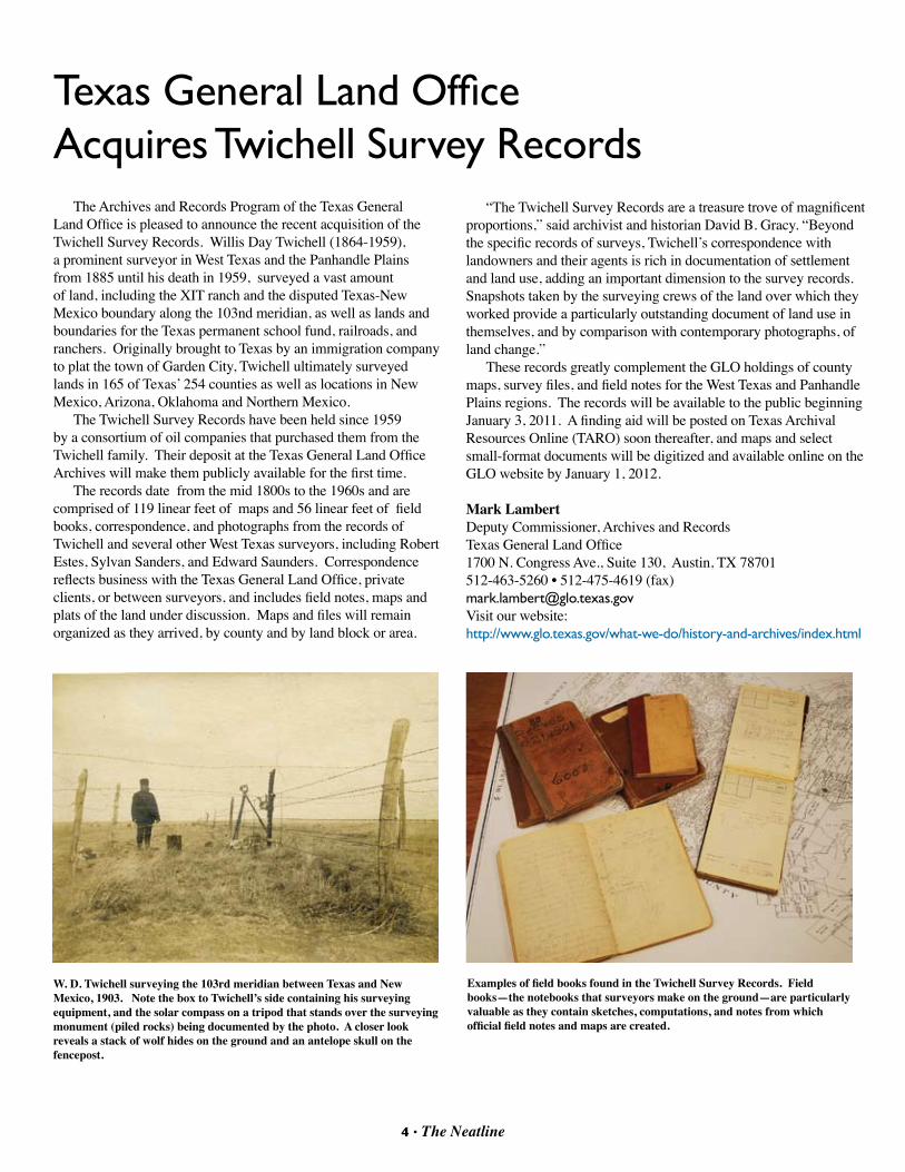
W. D. Twichell surveying the 103rd meridian between Texas and New Mexico, 1903. Note the box to Twichell’s side containing his surveying equipment, and the solar compass on a tripod that stands over the surveying monument (piled rocks) being documented by the photo. A closer look reveals a stack of wolf hides on the ground and an antelope skull on the fencepost.
Examples of field books found in the Twichell Survey Records. Field books—the notebooks that surveyors make on the ground—are particularly valuable as they contain sketches, computations, and notes from which official field notes and maps are created.
Texas General Land Office Acquires Twichell Survey Records
5 • The Neatline
MY FAvORITE MAP by Matt Walter
If you would like to submit an article about your own favorite map for a future issue of The Neatline, contact the editor David Finfrock at [email protected].
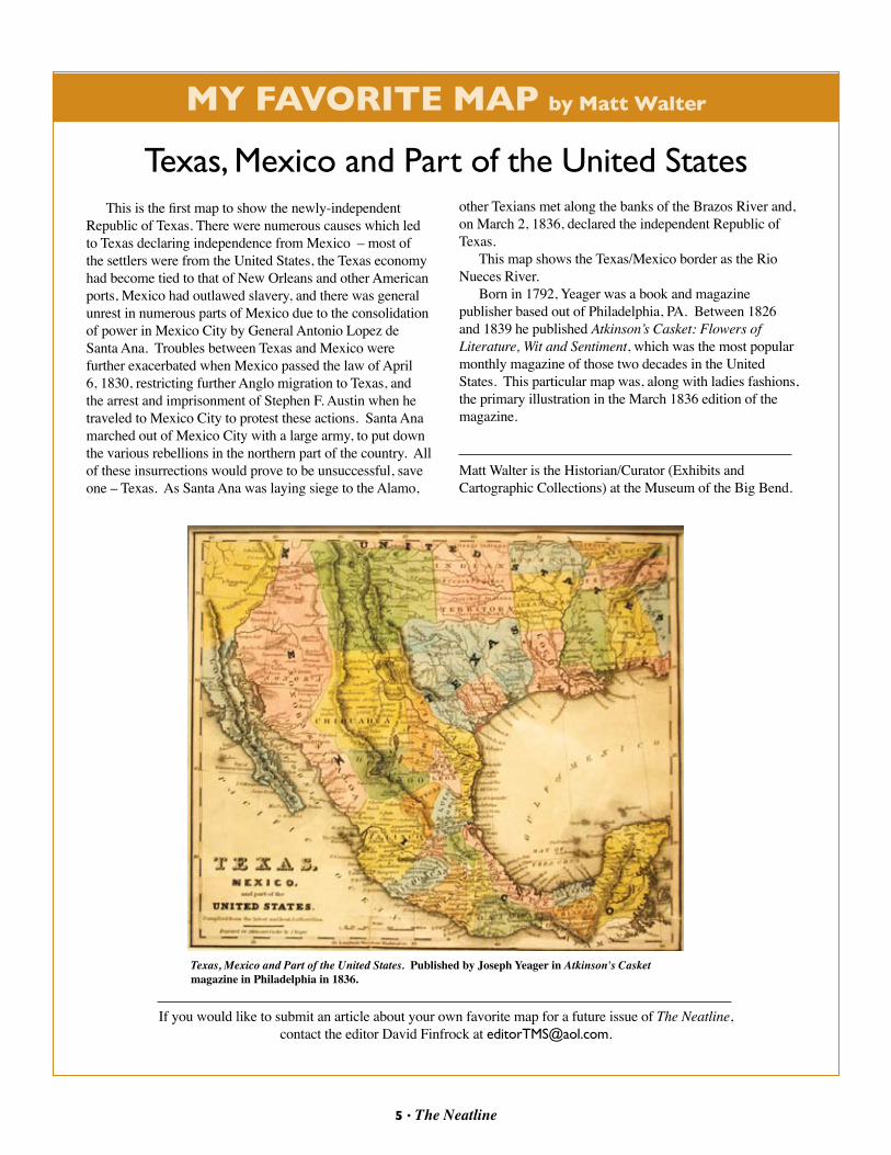
Texas, Mexico and Part of the United StatesThis is the first map to show the newly-independent
Republic of Texas. There were numerous causes which led to Texas declaring independence from Mexico – most of the settlers were from the United States, the Texas economy had become tied to that of New Orleans and other American ports, Mexico had outlawed slavery, and there was general unrest in numerous parts of Mexico due to the consolidation of power in Mexico City by General Antonio Lopez de Santa Ana. Troubles between Texas and Mexico were further exacerbated when Mexico passed the law of April 6, 1830, restricting further Anglo migration to Texas, and the arrest and imprisonment of Stephen F. Austin when he traveled to Mexico City to protest these actions. Santa Ana marched out of Mexico City with a large army, to put down the various rebellions in the northern part of the country. All of these insurrections would prove to be unsuccessful, save one – Texas. As Santa Ana was laying siege to the Alamo,
other Texians met along the banks of the Brazos River and, on March 2, 1836, declared the independent Republic of Texas.
This map shows the Texas/Mexico border as the Rio Nueces River.
Born in 1792, Yeager was a book and magazine publisher based out of Philadelphia, PA. Between 1826 and 1839 he published Atkinson’s Casket: Flowers of Literature, Wit and Sentiment, which was the most popular monthly magazine of those two decades in the United States. This particular map was, along with ladies fashions, the primary illustration in the March 1836 edition of the magazine.
Matt Walter is the Historian/Curator (Exhibits and Cartographic Collections) at the Museum of the Big Bend.
Texas, Mexico and Part of the United States. Published by Joseph Yeager in Atkinson's Casket magazine in Philadelphia in 1836.
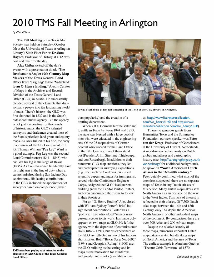
The Fall Meeting of the Texas Map Society was held on Saturday, October 9th at the University of Texas at Arlington Library’s Sixth Floor Parlor. Dr. Sam Haynes, Professor of History at UTA was host and chair for the day.
Alex Chiba kicked off the day’s events with a presentation titled, “The Draftsman’s Angle: 19th Century Map Makers of the Texas General Land Office from ‘Peg Leg’ to the ‘Vaterland’ to an O. Henry Ending.” Alex is Curator of Maps in the Archives and Records Division of the Texas General Land Office (GLO) in Austin. He successfully blended several of the elements that draw so many people into the fascinating world of maps. There’s history: the GLO was first chartered in 1837 and is the State’s oldest continuous agency. But the agency is not just a repository for thousands of historic maps, the GLO’s talented surveyors and draftsmen created most of the State’s priceless land grant and county maps. As Alex hinted in his title, the early mapmakers of the GLO were a colorful lot. Thomas William “Peg Leg” Ward is a good example. Peg Leg was the second Land Commissioner (1841 – 1848) who had lost his leg in the siege of Bexar (1835). As Commissioner, he literally gave his right arm in the line of duty when a cannon misfired during San Jacinto Day celebrations. His lasting contributions to the GLO included the appointment of surveyors based on competence (rather
2010 TMS Fall Meeting in ArlingtonBy Walt Wilson
than popularity) and the creation of a drafting department.
When 7,000 Germans left the Vaterland to settle in Texas between 1844 and 1853, the state was blessed with a large pool of men who were educated in the engineering arts. Of the 25 mapmakers of German descent who worked for the Land Office in the 19th Century, five of them stand out (Pressler, Arlitt, Stremme, Thielepape, and von Rosenberg). In addition to their numerous GLO map creations, they led and participated in surveying expeditions (e.g., for Jacob de Cordova), published scientific papers and maps for immigrants, served with the Confederate Engineer Corps, designed the GLO Headquarters building (now the Capitol Visitor Center), and even encouraged their sons to follow in their footsteps.
For an “O. Henry Ending” Alex closed with William Sydney Porter’s brief, but significant contributions. Porter was a “political” hire who added “unnecessary” pastoral scenes to his work. His name only appears on two maps at GLO. He left the agency with the departure of commissioner Hall (1887 – 1891), but his experiences at the GLO are reflected in two of his famous short stories. Both “Bexar Scrip No. 2692” (1894) and Georgia’s Ruling” (1900) use the GLO building as the setting and its maps as the motivation for murderous and greedy land sharks (available online
at: http://www.literaturecollection.com/a/o_henry/140/ and http://www.literaturecollection.com/a/o_henry/303/).
Thanks to generous grants from Humanities Texas and the Summerlee Foundation, our next speaker was Peter van der Krogt, Professor of Geosciences at the University of Utrecht, Netherlands. A world-renowned authority on Dutch globes and atlases and cartographic history (see: http://cartography.geog.uu.nl/vanderkrogt/ for additional background), he spoke on “North America in Dutch Atlases in the 16th-20th century.” Peter quickly confirmed what most of the attendees suspected: there are no separate maps of Texas in any Dutch atlases of this period. Many Dutch mapmakers saw North America as an obstacle on the way to the West Indies. This lack of interest is reflected in their atlases. Of 7,500 Dutch atlas maps between the 16th and 18th Century, only 184 depict the Americas, North America, or other individual maps of the continent. By comparison there are over 500 Asian and 200 African maps.
Despite the relative scarcity of these maps, numerous important Dutch mapmakers created breathtaking maps of North America and the area of Texas. The earliest example is Abraham Ortelius’ “Theatur Orbis Terrarum” of 1570.
It was a full house at last fall's meeting of the TMS at the UTA library in Arlington.
TMS members paying rapt attention to the discourse by Alex Chiba of the Texas General Land Office.
6 • The Neatline
Continued on page 7
6 • The Neatline
Generally recognized as the first modern atlas, it had one map of America. Later editions added the east coast of Mexico and the 1584 edition included a map of “La Florida” by the cartographer Chavez’ which extended to the Rio Escondido (Rio Grande) and Central Texas.
The popularity of the Ortelius atlases probably contributed to the sluggish sales of Gerard de Jode’s “Speculum Orbis Terrarum” (1578), that included the first separate map of North America. Another competitor and arguably the most important mapmaker of the 16th century, Gerard Mercator (1512-1594), never made a separate map of North America. Shortly after Mercator’s death, Cornelis van Wijtfliet (Wytfliet) published the first atlas devoted to Americas, (Descriptionis Plolomaicae Augmentum, 1597); it had 19 derivative regional maps.
In 1606, Hondius published an Atlas with 37 new maps, including one of Virginia (based on Smith and le Moyne) and New Spain. His sons took over in 1612, but there was little competition and not much change. Willem Jansz Blaeu and sons carried on the tradition of Hondius, and published their first atlas in 1630 that
included the Smith map of Virginia. Blaeu just put his name on it in place of Hondius (his Indian is looking away from the map).
Blaeu began publishing his atlases in other languages other than Latin and in 1634 added two new maps of North America including one of New Spain whose inhabitants, “mostly live on hunting and fruits.” This area was included in many atlases such as the 1638 Janssoniius edition that labeled the Texas area as “Nueva Granada.” There were a number of second generation Dutch mapmakers that included North America in their atlases, but French mapmaking eventually surpassed the Dutch. However, Dutch production methods continued to be superior as they copied the new French maps and produced higher quality versions at lower cost (e.g., the Amsterdam editions of De l’Isles’ atlases). For Dutch mapmakers, Texas would always remain a “Region of which we do not have particular knowledge.”
Andrew Torget, Assistant Professor of History at the University of North Texas spoke on “Slavery and the Southwest: Mapping People and Ideas in Early Texas.” Andrew discussed the application of innovative digital scholarship methods to the Texas Slavery Project and the study of slavery’s role in the development of Texas prior to statehood. Establishment of a cotton economy was a key element of Stephen F. Austin’s effort to establish Texas as a viable state. His land grants were for 4,220 acres instead of the 160 that were common in US territories. About 90% of the earliest Texians came from the American south and most of these were men and women from Mississippi and Alabama who were looking for new and fertile fields to grow cotton. Austin believed that cotton was the primary product that could elevate his colony from poverty and it appeared that this goal could not be reached without slaves.
A small complication in the plan was the fact that slavery was illegal in Mexico. Those Cotton planters that did not simply ignore the law implemented a level of servitude that was de facto slavery. The first constitution of Texas rectified this problem by following the lead of the United States. Slavery was not only legal
in Texas, it could never be outlawed and slaves could not be freed, and if they were, they could not live in the Republic of Texas.
Within this context, several important, but unanswered questions arise. For example, how important was slave labor to the Texas economy and where did they come from; did slaveholders in Texas import slaves from Africa? To help answer these and other questions, Andrew used digital mapping of historical sources. Census and tax records were important resources. In 1837, the Republic was broke and to raise money, County Sheriffs were tasked to itemize taxable personal possession including horses, clocks, watches, pleasure carriages, mules, land, and slaves.
By mapping county slave and master population by location and date, Andrew’s initial analysis indicated that the total slave population increased 557% while the master population increased 417% from 1837 to 1846. Wealthy cotton growers with larger slave holdings were primarily located in east Texas and Austin’s Colony. While hydrology was an important factor, the deciding issues for this demographic were security and easy transportation to New Orleans. After the Mexican invasions of 1842, many of the cotton planters in Travis and Fayette Counties retreated to east Texas or across the border into United States. After 1843, there was a relatively flat increase in the number of slaves
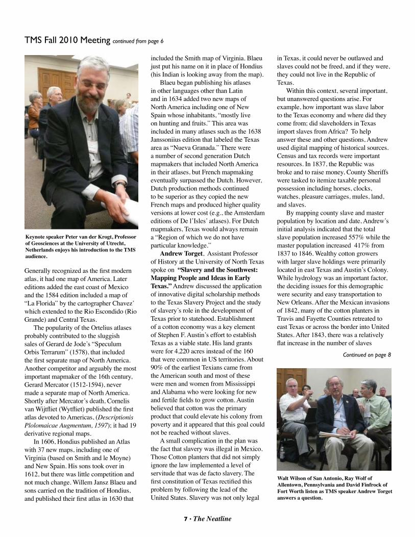
Keynote speaker Peter van der Krogt, Professor of Geosciences at the University of Utrecht, Netherlands enjoys his introduction to the TMS audience.
7 • The Neatline
TMS Fall 2010 Meeting continued from page 6
Continued on page 8
Walt Wilson of San Antonio, Ray Wolf of Allentown, Pennsylvania and David Finfrock of Fort Worth listen as TMS speaker Andrew Torget answers a question.
and the proportion of slaves and owners remained constant. An early conclusion is that slaves entered and exited the state with their masters and were not illegally imported in slave-ships from Africa.
There are several challenges in compiling this data, not the least of which is incomplete or missing records. However, there are exciting opportunities to fill in the gaps using primary sources. This effort requires the relatively new data mining discipline of “language mapping.” Andrew is working with others to find relationships in words to extract meaning and trends from contemporary documents. For example “cotton” is most often
associated with Texian, raw production culture, duty, markets, and privilege. The topic of slaves and slavery is frequently found in association with the words: Government, shall, Mexico, states, tax, Texas treaty, trade, African, African Slave trade, and suppression. These efforts to connect documents and letters with the physical landscape should continue to provide insights to our history.
Lunch Business Meeting. President Dianne Powell offered thanks to Board members Lynne Starnes Treasurer, Ben Huseman Secretary, Gerald Saxon Programs and facilities, Carolyn Kadri, and David Finfrock editor of the new
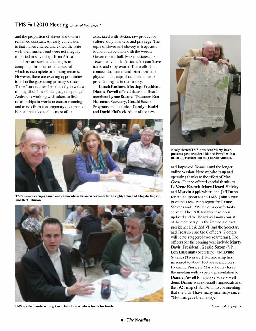
and improved Neatline and the longer online version. New website is up and operating thanks to the effort of Max Gross. Dianne offered special thanks to LaVerne Knezek, Mary Heard, Shirley and Marvin Applewhite, and Jeff Dunn for their support to the TMS. John Crain gave the Treasurer’s report for Lynne Starnes and TMS remains comfortably solvent. The 1996 bylaws have been updated and the Board will now consist of 14 members plus the immediate past president (1st & 2nd VP and the Secretary and Treasurer are the 6 officers; 9 others will serve staggered two year terms). The officers for the coming year include Marty Davis (President), Gerald Saxon (VP), Ben Huseman (Secretary), and Lynne Starnes (Treasurer). Membership has increased to about 160 active members. Incoming President Marty Davis closed the meeting with a special presentation to Dianne Powell for a job very, very well done. Dianne was especially appreciative of the 1921 map of San Antonio commenting that she didn’t have many nice maps since “Momma gave them away.”
TMS speaker Andrew Torget and John Freese take a break for lunch.
Newly elected TMS president Marty Davis presents past president Dianne Powell with a much appreciated old map of San Antonio.
8 • The Neatline
TMS Fall 2010 Meeting continued from page 7
Continued on page 9
TMS members enjoy lunch and camaraderie between sessions: left to right, John and Magola English and Bert Johnson.
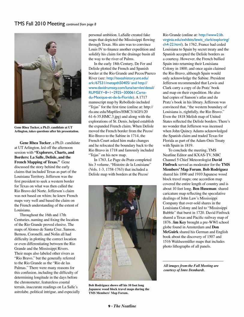
Gene Rhea Tucker, a Ph.D. candidate at UT Arlington, led off the afternoon session with “Explorers, Charts, and Borders: La Salle, Delisle, and the French Mapping of Texas.” Gene discussed the story behind the early claims that included Texas as part of the Louisiana Territory. Jefferson was the first president to seek a western border for Texas on what was then called the Rio Bravo del Norte. Jefferson’s claim was not based on whim; he knew French maps very well and based the claim on the French understanding of the extent of Louisiana.
Throughout the 16th and 17th Centuries, naming and fixing the location of the Rio Grande proved elusive. The maps of Alonso de Santa Cruz, Sanson, Bernou, Coronelli, and Nolin all had difficulty in plotting the correct location or even differentiating between the Rio Grande and the Mississippi Rivers. Their maps also labeled other rivers as “Rio Bravo,” but the generally referred to the Rio Grande as the “Rio de las Palmas.” There were many reasons for this confusion, including the difficulty of determining longitude in the days before the chronometer, featureless coastal terrain, inaccurate readings on La Salle’s astrolabe, political intrigue, and especially
9 • The Neatline
Bob Rodriguez shows off his 10 foot long Japanese wood block travel maps during the TMS Members' Map Forum.
Gene Rhea Tucker, a Ph.D. candidate at UT Arlington, takes questions after his presentation.
personal ambition. LaSalle created fake maps that depicted the Mississippi flowing through Texas. His aim was to convince Louis IV to finance another expedition and solidify his claim for the drainage basin all the way to the river of Palms.
In the early 18th Century, De Fer and Delisle plotted the French and Spanish border at the Rio Grande and Pecos/Puerco River (see: http://texashistory.unt.edu/ark:/67531/metapth50405/ and http://www.davidrumsey.com/luna/servlet/detail/RUMSEY~8~1~2925~300061:Carte-du-Mexique-et-de-la-Floride). A 1717 manuscript map by Rebolledo included “Tejas” for the first time (online at: http://rla.unc.edu/Mapfiles/HMC3/AGI%2061-6-35.HMC.3.jpg) and along with the explorations of St. Denis, helped establish the expanded French claim. When Delisle moved the French border from the Pecos/Rio Bravo to the Sabine in 1714, the French Court asked him make changes and he relocated the boundary back to the Rio Bravo in 1718 and famously included “Tejas” on his new map.
In 1763, Le Page du Pratz completed his 3 volume, “Histoire de la Louisiane” (Vols. 1-3, 1758-1763) that included a Delisle map with borders at the Pecos/
All images from the Fall Meeting are courtesy of Imre Demhardt.
Rio Grande (online at: http://www2.lib.virginia.edu/exhibits/lewis_clark/exploring/ch4-22.html). In 1762, France had ceded Louisiana to Spain by secret treaty and the Spanish accepted the Delisle borders as a courtesy. However, the French bullied Spain into returning their Louisiana Colony in 1800, and once again claimed the Rio Bravo, although Spain would only acknowledge the Sabine. President Jefferson recommended that Lewis and Clark carry a copy of du Pratz’ book and map on their expedition. He also had copies of Sanson’s atlas and du Pratz’s book in his library. Jefferson was convinced that, “the western boundary of Louisiana is, rightfully, the Rio Bravo.” Even the 1818 Melish map of United States reflected the Delisle borders. There’s no wonder that Jefferson was incensed when John Quincy Adams acknowledged the Spanish claim and traded Texas for Florida as part of the Adam-Onis Treaty with Spain in 1819.
To conclude the meeting, TMS Neatline Editor and KXAS-TV, NBC Channel 5 Chief Meteorologist David Finfrock served as moderator for the TMS Members’ Map Forum. Bob Rodriguez shared his 1890 and 1910 Japanese wood block travel maps; one accordion map covered the entire length of country and is about 10 feet long. Ben Huseman: shared caricature map reflecting the speculative dealings of John Law’s Mississippi Company that over-sold shares in the Louisiana Colony and led to “Mississippi Bubble” that burst in 1720. David Finfrock shared a Texas and Pacific railway map of 1876. Jim Key brought a pre-WWI school globe found in Amsterdam and Don McGuirk shared his German and English book about the discovery of 1507 and 1516 Waldseemüller maps that includes photo lithographs of all panels.
TMS Fall 2010 Meeting continued from page 8
10 • The Neatline
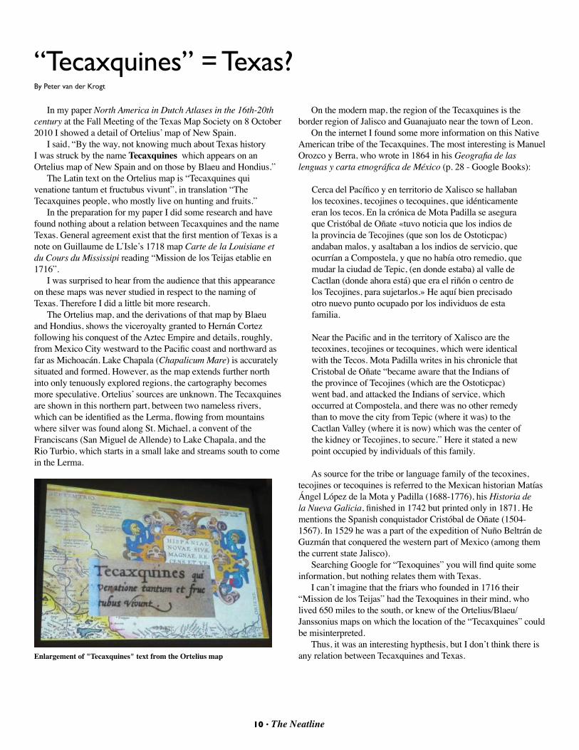
In my paper North America in Dutch Atlases in the 16th-20th century at the Fall Meeting of the Texas Map Society on 8 October 2010 I showed a detail of Ortelius’ map of New Spain.
I said, “By the way, not knowing much about Texas history I was struck by the name Tecaxquines which appears on an Ortelius map of New Spain and on those by Blaeu and Hondius.”
The Latin text on the Ortelius map is “Tecaxquines qui venatione tantum et fructubus vivunt”, in translation “The Tecaxquines people, who mostly live on hunting and fruits.”
In the preparation for my paper I did some research and have found nothing about a relation between Tecaxquines and the name Texas. General agreement exist that the first mention of Texas is a note on Guillaume de L’Isle’s 1718 map Carte de la Louisiane et du Cours du Mississipi reading “Mission de los Teijas etablie en 1716”.
I was surprised to hear from the audience that this appearance on these maps was never studied in respect to the naming of Texas. Therefore I did a little bit more research.
The Ortelius map, and the derivations of that map by Blaeu and Hondius, shows the viceroyalty granted to Hernán Cortez following his conquest of the Aztec Empire and details, roughly, from Mexico City westward to the Pacific coast and northward as far as Michoacán. Lake Chapala (Chapalicum Mare) is accurately situated and formed. However, as the map extends further north into only tenuously explored regions, the cartography becomes more speculative. Ortelius’ sources are unknown. The Tecaxquines are shown in this northern part, between two nameless rivers, which can be identified as the Lerma, flowing from mountains where silver was found along St. Michael, a convent of the Franciscans (San Miguel de Allende) to Lake Chapala, and the Rio Turbio, which starts in a small lake and streams south to come in the Lerma.
On the modern map, the region of the Tecaxquines is the border region of Jalisco and Guanajuato near the town of Leon.
On the internet I found some more information on this Native American tribe of the Tecaxquines. The most interesting is Manuel Orozco y Berra, who wrote in 1864 in his Geografia de las lenguas y carta etnográfica de México (p. 28 - Google Books):
Cerca del Pacífico y en territorio de Xalisco se hallaban los tecoxines, tecojines o tecoquines, que idénticamente eran los tecos. En la crónica de Mota Padilla se asegura que Cristóbal de Oñate «tuvo noticia que los indios de la provincia de Tecojines (que son los de Ostoticpac) andaban malos, y asaltaban a los indios de servicio, que ocurrían a Compostela, y que no había otro remedio, que mudar la ciudad de Tepic, (en donde estaba) al valle de Cactlan (donde ahora está) que era el riñón o centro de los Tecojines, para sujetarlos.» He aquí bien precisado otro nuevo punto ocupado por los individuos de esta familia.
Near the Pacific and in the territory of Xalisco are the tecoxines, tecojines or tecoquines, which were identical with the Tecos. Mota Padilla writes in his chronicle that Cristobal de Oñate “became aware that the Indians of the province of Tecojines (which are the Ostoticpac) went bad, and attacked the Indians of service, which occurred at Compostela, and there was no other remedy than to move the city from Tepic (where it was) to the Cactlan Valley (where it is now) which was the center of the kidney or Tecojines, to secure.” Here it stated a new point occupied by individuals of this family.
As source for the tribe or language family of the tecoxines, tecojines or tecoquines is referred to the Mexican historian Matías Ángel López de la Mota y Padilla (1688-1776), his Historia de la Nueva Galicia, finished in 1742 but printed only in 1871. He mentions the Spanish conquistador Cristóbal de Oñate (1504-1567). In 1529 he was a part of the expedition of Nuño Beltrán de Guzmán that conquered the western part of Mexico (among them the current state Jalisco).
Searching Google for “Texoquines” you will find quite some information, but nothing relates them with Texas.
I can’t imagine that the friars who founded in 1716 their “Mission de los Teijas” had the Texoquines in their mind, who lived 650 miles to the south, or knew of the Ortelius/Blaeu/Janssonius maps on which the location of the “Tecaxquines” could be misinterpreted.
Thus, it was an interesting hypthesis, but I don’t think there is any relation between Tecaxquines and Texas.
“Tecaxquines” = Texas?By Peter van der Krogt
Enlargement of "Tecaxquines" text from the Ortelius map
11 • The Neatline
In 1492, Christopher Columbus set into motion a pattern of exploration which changed the world. Up to that point, Europeans – like Marco Polo – had always headed eastward in their quest for the fabled riches and spices of China and India – the Far East. Arab and Persian traders, from the Middle East, had been the primary links between the Kings and Queens of Europe and the treasures of Asia. But as new European city-states and kingdoms began emerging out of the Medieval Period, and as the Arabs and Persians were defeated and pushed from the Iberian Peninsula and the Mediterranean Sea, trade between the new European kingdoms and the Orient was cut off.
Under the leadership of Prince Henry the Navigator, the kingdom of Portugal sent out the first explorers to attempt to re-connect Europe with China and India. Portuguese ships explored down the Atlantic coast of Africa, rounded the Horn, and then headed eastward into the Indian Sea. When the rest of the Iberian Peninsula was united by the marriage of Ferdinand of Aragon and Isabela of Castille, the kingdom of Spain came into existence. Also wanting to reach the riches of the Far East, but not competing directly with Portugal in that quest, the new rulers of Spain listened with great interest to the ideas of a young Italian navigator, Cristobal Colon. Columbus, as he came to be called,
WESTWARD FOR WEALTH!Maps of exploration, territorial expansion and the quest for prosperity in the Americas.
By Matt Walter
convinced the new Regents that it would be much quicker to sail westward to reach the wealth of Asia. What he did not know was that a whole continent stood in his way! The discovery of this new continent, with unexpected sources of wealth and new lands to explore, changed the world forever. Explorers, adventurers, and traders for the first time began to look westward for wealth.
Fifty maps, part of the Yana and Marty Davis Collection at the Museum of the Big Bend, are currently on exhibit at the Petroleum Museum in Midland, TX. These maps help document and tell the story of this new pattern of exploration and expansion. These maps tell stories of adventure and intrigue, murder and war, success and failure, and of people, both good and not-so-good. In other words, these maps help tell the story of the westward expansion of America, often driven by the quest for wealth.
Stop by in Midland on your way to the Spring TMS meeting to see this fabulous collection. The Petroleum Museum is located at 1500 West Interstate 20 in Midland, TX. You can learn more about the exhibit here:http://petroleummuseum.org/Exhibits/FeaturedExhibits2.html
New Map Museum Opens in La Jolla By Dianne Powell
If your travel plans take you to southern California, you might want to visit the nation's newest museum of antique maps. Mike Stone, an avid collector, has opened a private museum in La Jolla. The following article by John Wilkens in the San Diego Union-Tribune provides much more information: http://www.signonsandiego.com/news/2011/feb/08/collector-charts-new-course-with-map-museum-in-l
12 • The Neatline
TMS Officers and BoardOFFICERS
BOard MeMBerS (Jan 2010 - dec 2011)
BOard MeMBerS (Jan 2011- dec 2012)
President Marty DavisJan 2011 - Dec 2012 Fort Davis, TX [email protected]
First Vice President Dr. Gerald SaxonJan 2011 - Dec 2012 Arlington, [email protected]
Second Vice President Shirley ApplewhiteJan 2011 - Dec 2012Fort Worth, [email protected]
Secretary Ben HusemanJan 2010 - Dec 2011Arlington, [email protected]
Treasurer Lynne StarnesJan 2010 - Dec 2011Dallas, TX [email protected]
UNELECTEd OFFICERS
editor, The NeatlineDavid FinfrockCedar Hill, [email protected]
Website ManagerMax GrossDallas, [email protected]
Mark DavidMcKinney, [email protected]
Dr. Imre DemhardtArlington, [email protected]
Jonathan K. GerlandDiboll, [email protected]
Dr. Mary L. VolcansekFort Worth, [email protected]
Joe FletcherMcAllen, TX [email protected]
Mary HeardSan Antonio, [email protected]
Dr. Russell L. MartinDallas, [email protected]
David MurphGrapevine, [email protected]
Margaret (“Peggy”) N. RiddleDallas, TX [email protected]