Embed Size (px)
Citation preview
FS 2H - GNSS CORS Networks - Positioning Infrastructure, Analysis and Applications II Andreas Knoepfler, Frederic Masson, Michael Mayer, Patrice Ulrich, and Bernhard Heck GURN (GNSS Upper Rhine Graben Network) – Status and first Results FIG Congress 2010 Facing the Challenges – Building the Capacity Sydney, Australia, 11-16 April 2010
1/14
GURN (GNSS Upper Rhine Graben Network) – Status and first Results
Andreas KNOEPFLER, Michael MAYER, Bernhard HECK (all Germany) and
Frederic MASSON, Patrice ULRICH (both France)
Key words: Permanent GNSS sites, recent crustal motions, Upper Rhine Graben SUMMARY
In September 2008 the Institut de Physique du Globe de Strasbourg (Ecole et Observatoire des Sciences de la Terre) and the Geodetic Institute of Karlsruhe University established a transnational cooperation called GURN (GNSS Upper Rhine Graben Network). Within the GURN initiative these institutions are cooperating in order to carry out geo-scientific research in the framework of the transnational project TOPO-WECEP (Western and Central European Platform; link: http://www.topo-wecep.eu/), which succeeded the former project URGENT (Upper Rhine Graben Evolution and NeoTectonics; link: http://comp1.geol.unibas.ch/) of the EUCOR universities (European Confederation of Upper Rhine Universities). The research is actually based on GNSS (Global Navigation Satellite Systems) in order to establish a highly precise and highly sensitive network of permanently operating GNSS sites for the detection of recent crustal movements in the Upper Rhine Graben (URG) region. At the beginning, the network existed of the permanent operating sites of SAPOS
® Baden-Württemberg, different data providers in France (e.g. EOST, Teria, RGP, …) and some further sites (e.g. IGS). In July 2009, the network was extended to the South when swisstopo (Switzerland) and to the North when SAPOS
® Rheinland-Pfalz joined GURN. Therefore, actually the GNSS network consists of approx. 80 permanently operating reference sites. The presentation will discuss the actual status of GURN, main research goals and will present first results concerning the data quality as well as time series of a first reprocessing of all available data since 2002 using GAMIT/GLOBK (EOST) and the Bernese GPS Software (GIK).
FS 2H - GNSS CORS Networks - Positioning Infrastructure, Analysis and Applications II Andreas Knoepfler, Frederic Masson, Michael Mayer, Patrice Ulrich, and Bernhard Heck GURN (GNSS Upper Rhine Graben Network) – Status and first Results FIG Congress 2010 Facing the Challenges – Building the Capacity Sydney, Australia, 11-16 April 2010
2/14
GURN (GNSS Upper Rhine Graben Network) – Status and first Results
Andreas KNOEPFLER, Michael MAYER, Bernhard HECK (all Germany) and
Frederic MASSON, Patrice ULRICH (both France)
1. INTRODUCTION
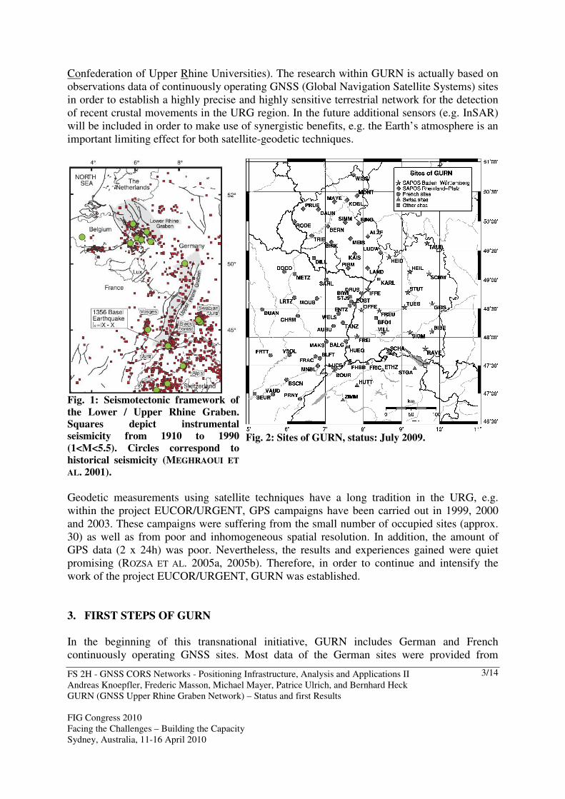
The Rhine Graben is the central, most prominent segment of the European Cenozoic rift system which extends from the North Sea through Germany and France to the Mediterranean sea over a distance of some 1000 km (ZIEGLER 1992; BOURGEOIS ET AL. 2007). Within the here described transnational geo-scientific project GURN (GNSS Upper Rhine Graben Network) the focus will be on the Upper Rhine Graben (URG). The URG is a 300 km long and 40 km wide SSW-NNE trending rift, extending from Basel (Switzerland) to Frankfurt (Germany). It is bounded to the west by the Vosges mountains and to the east by the Black Forest. The graben is bounded to the north by the uplifted area of the Rhenish Massif. To the south, the Leymen, Ferrette, and Vendlincourt folds represent the northern-most structural front of the Jura fold and Thrust belt. This thin-skinned compressive deformation front propagates 30 km further to the north up to Mulhouse (France). Preceded by late Cretaceous volcanism, the rifting was initiated during Late Eocene to early Miocene (42-31 Ma) starting with broadly E-W resp. ENE-WSW extension and lasted until Aquitanian time (20 Ma). Today, the southern end of the Rhine Graben is characterised by small uplift and subsidence rates and by a quasi-compressive, left-lateral strike-slip tectonic regime, with a maximum stress-axis oriented NW-SE. The URG is considered to be the most seismically active region of northwest Europe with significant probability for the occurrence of large earthquakes (MEGHRAOUI ET AL. 2001; see Fig. 1). For a better understanding of the processes that lead to seismic activity in the URG, it is necessary to study not only the location of the faults but also their kinematics. Seismic hazard assessment in this region is hindered by a lack of information on the time-dependent behaviour of active structures. GURN will contribute to remedy this regional defect. In Sect. 2 the recent status of the GNSS Upper Rhine Graben Network will be described. Sect. 3 gives an overview on the first steps within GURN. In Sect. 4 some first GURN results are presented. The paper is closing with an outlook on future goals of GURN (Sect. 5). 2. THE GNSS UPPER RHINE GRABEN NETWORK GURN
In September 2008, the Ecole et Observatoire des Sciences de la Terre (EOST, CNRS and Strasbourg University, France) and the Geodetic Institute of the Karlsruhe University (GIK, Germany) established a transnational cooperation called GURN. Within the GURN initiative these institutions are cooperating in order to carry out geo-scientific research in the framework of the transnational project TOPO-WECEP (Western and Central European Platform; link: http://www.topo-wecep.eu/; CLOETINGH ET AL. 2007), which succeeded the former project URGENT (Upper Rhine Graben Evolution and NeoTectonics; link: http://comp1.geol.unibas.ch/; BEHRMANN ET AL. 2005) of the EUCOR universities (European
FS 2H - GNSS CORS Networks - Positioning Infrastructure, Analysis and Applications II Andreas Knoepfler, Frederic Masson, Michael Mayer, Patrice Ulrich, and Bernhard Heck GURN (GNSS Upper Rhine Graben Network) – Status and first Results FIG Congress 2010 Facing the Challenges – Building the Capacity Sydney, Australia, 11-16 April 2010
3/14
Confederation of Upper Rhine Universities). The research within GURN is actually based on observations data of continuously operating GNSS (Global Navigation Satellite Systems) sites in order to establish a highly precise and highly sensitive terrestrial network for the detection of recent crustal movements in the URG region. In the future additional sensors (e.g. InSAR) will be included in order to make use of synergistic benefits, e.g. the Earth’s atmosphere is an important limiting effect for both satellite-geodetic techniques.
Fig. 1: Seismotectonic framework of
the Lower / Upper Rhine Graben.
Squares depict instrumental
seismicity from 1910 to 1990
(1<M<5.5). Circles correspond to
historical seismicity (MEGHRAOUI ET
AL. 2001).
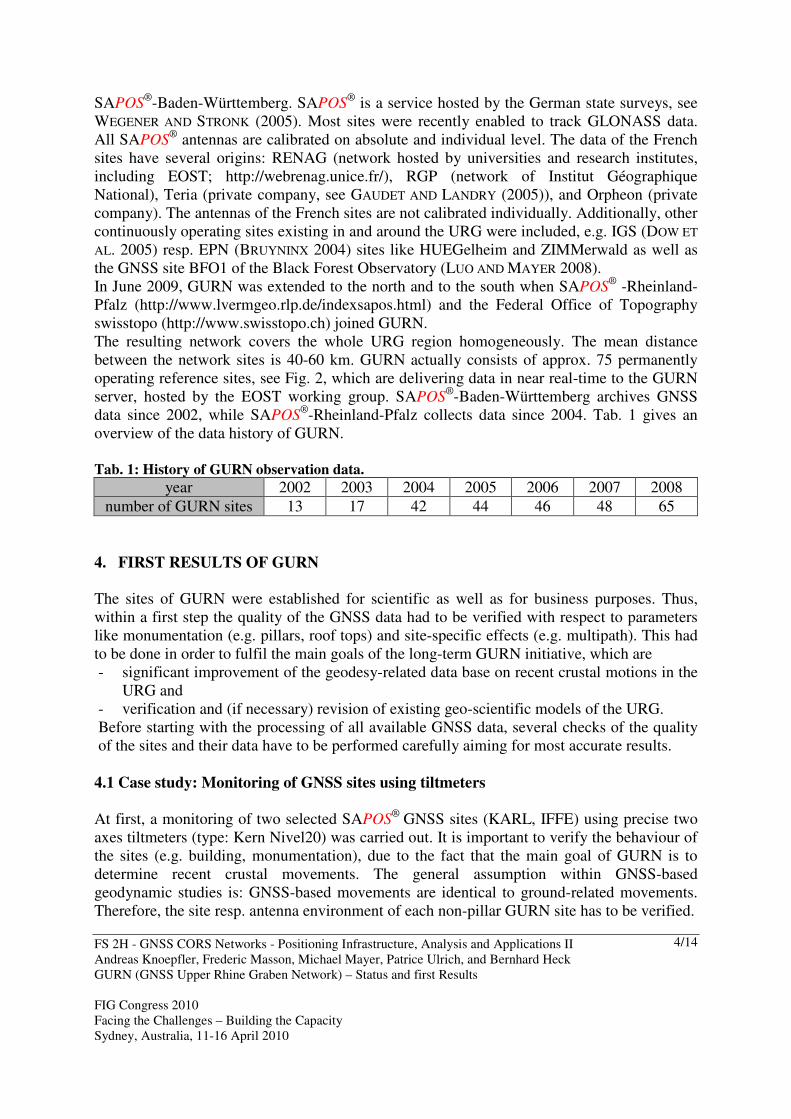
Fig. 2: Sites of GURN, status: July 2009.
Geodetic measurements using satellite techniques have a long tradition in the URG, e.g. within the project EUCOR/URGENT, GPS campaigns have been carried out in 1999, 2000 and 2003. These campaigns were suffering from the small number of occupied sites (approx. 30) as well as from poor and inhomogeneous spatial resolution. In addition, the amount of GPS data (2 x 24h) was poor. Nevertheless, the results and experiences gained were quiet promising (ROZSA ET AL. 2005a, 2005b). Therefore, in order to continue and intensify the work of the project EUCOR/URGENT, GURN was established. 3. FIRST STEPS OF GURN
In the beginning of this transnational initiative, GURN includes German and French continuously operating GNSS sites. Most data of the German sites were provided from
FS 2H - GNSS CORS Networks - Positioning Infrastructure, Analysis and Applications II Andreas Knoepfler, Frederic Masson, Michael Mayer, Patrice Ulrich, and Bernhard Heck GURN (GNSS Upper Rhine Graben Network) – Status and first Results FIG Congress 2010 Facing the Challenges – Building the Capacity Sydney, Australia, 11-16 April 2010
4/14
SAPOS®-Baden-Württemberg. SAPOS
® is a service hosted by the German state surveys, see WEGENER AND STRONK (2005). Most sites were recently enabled to track GLONASS data. All SAPOS
® antennas are calibrated on absolute and individual level. The data of the French sites have several origins: RENAG (network hosted by universities and research institutes, including EOST; http://webrenag.unice.fr/), RGP (network of Institut Géographique National), Teria (private company, see GAUDET AND LANDRY (2005)), and Orpheon (private company). The antennas of the French sites are not calibrated individually. Additionally, other continuously operating sites existing in and around the URG were included, e.g. IGS (DOW ET
AL. 2005) resp. EPN (BRUYNINX 2004) sites like HUEGelheim and ZIMMerwald as well as the GNSS site BFO1 of the Black Forest Observatory (LUO AND MAYER 2008). In June 2009, GURN was extended to the north and to the south when SAPOS
® -Rheinland-Pfalz (http://www.lvermgeo.rlp.de/indexsapos.html) and the Federal Office of Topography swisstopo (http://www.swisstopo.ch) joined GURN. The resulting network covers the whole URG region homogeneously. The mean distance between the network sites is 40-60 km. GURN actually consists of approx. 75 permanently operating reference sites, see Fig. 2, which are delivering data in near real-time to the GURN server, hosted by the EOST working group. SAPOS
®-Baden-Württemberg archives GNSS data since 2002, while SAPOS
®-Rheinland-Pfalz collects data since 2004. Tab. 1 gives an overview of the data history of GURN. Tab. 1: History of GURN observation data.
year 2002 2003 2004 2005 2006 2007 2008 number of GURN sites 13 17 42 44 46 48 65
4. FIRST RESULTS OF GURN The sites of GURN were established for scientific as well as for business purposes. Thus, within a first step the quality of the GNSS data had to be verified with respect to parameters like monumentation (e.g. pillars, roof tops) and site-specific effects (e.g. multipath). This had to be done in order to fulfil the main goals of the long-term GURN initiative, which are - significant improvement of the geodesy-related data base on recent crustal motions in the
URG and - verification and (if necessary) revision of existing geo-scientific models of the URG. Before starting with the processing of all available GNSS data, several checks of the quality of the sites and their data have to be performed carefully aiming for most accurate results.
4.1 Case study: Monitoring of GNSS sites using tiltmeters
At first, a monitoring of two selected SAPOS
® GNSS sites (KARL, IFFE) using precise two axes tiltmeters (type: Kern Nivel20) was carried out. It is important to verify the behaviour of the sites (e.g. building, monumentation), due to the fact that the main goal of GURN is to determine recent crustal movements. The general assumption within GNSS-based geodynamic studies is: GNSS-based movements are identical to ground-related movements. Therefore, the site resp. antenna environment of each non-pillar GURN site has to be verified.
FS 2H - GNSS CORS Networks - Positioning Infrastructure, Analysis and Applications II Andreas Knoepfler, Frederic Masson, Michael Mayer, Patrice Ulrich, and Bernhard Heck GURN (GNSS Upper Rhine Graben Network) – Status and first Results FIG Congress 2010 Facing the Challenges – Building the Capacity Sydney, Australia, 11-16 April 2010
5/14
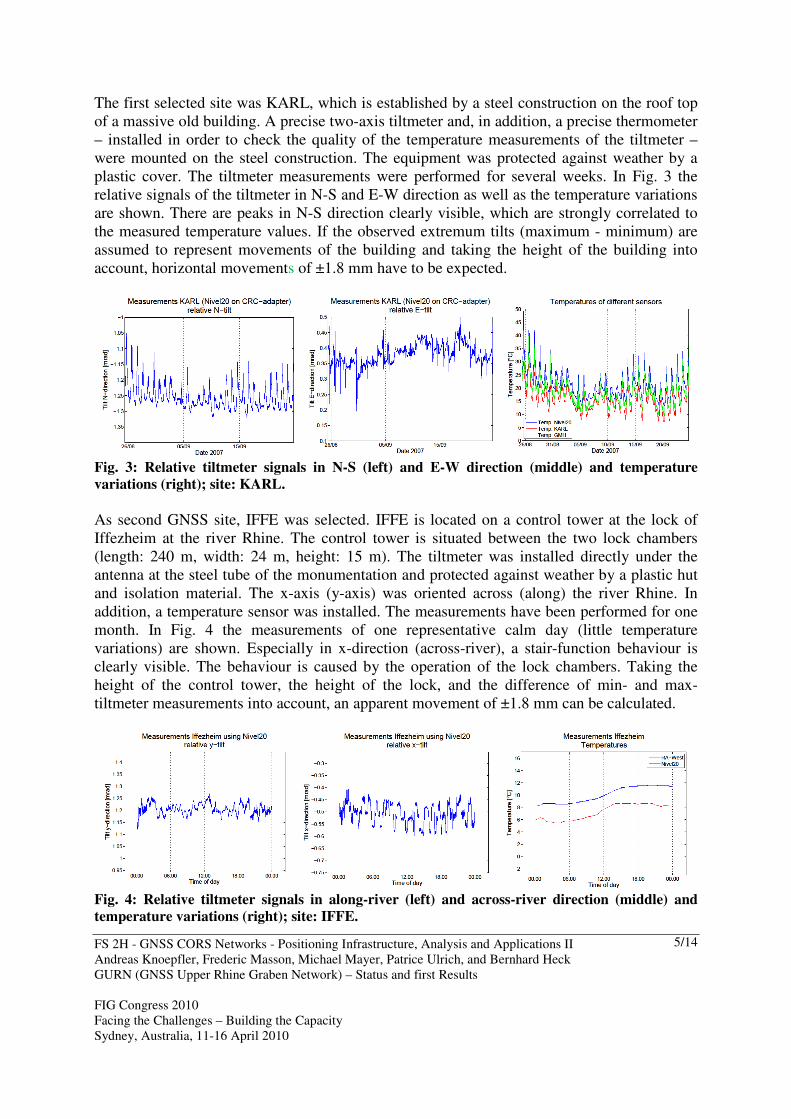
The first selected site was KARL, which is established by a steel construction on the roof top of a massive old building. A precise two-axis tiltmeter and, in addition, a precise thermometer – installed in order to check the quality of the temperature measurements of the tiltmeter – were mounted on the steel construction. The equipment was protected against weather by a plastic cover. The tiltmeter measurements were performed for several weeks. In Fig. 3 the relative signals of the tiltmeter in N-S and E-W direction as well as the temperature variations are shown. There are peaks in N-S direction clearly visible, which are strongly correlated to the measured temperature values. If the observed extremum tilts (maximum - minimum) are assumed to represent movements of the building and taking the height of the building into account, horizontal movements of ±1.8 mm have to be expected.
Fig. 3: Relative tiltmeter signals in N-S (left) and E-W direction (middle) and temperature
variations (right); site: KARL.
As second GNSS site, IFFE was selected. IFFE is located on a control tower at the lock of Iffezheim at the river Rhine. The control tower is situated between the two lock chambers (length: 240 m, width: 24 m, height: 15 m). The tiltmeter was installed directly under the antenna at the steel tube of the monumentation and protected against weather by a plastic hut and isolation material. The x-axis (y-axis) was oriented across (along) the river Rhine. In addition, a temperature sensor was installed. The measurements have been performed for one month. In Fig. 4 the measurements of one representative calm day (little temperature variations) are shown. Especially in x-direction (across-river), a stair-function behaviour is clearly visible. The behaviour is caused by the operation of the lock chambers. Taking the height of the control tower, the height of the lock, and the difference of min- and max-tiltmeter measurements into account, an apparent movement of ±1.8 mm can be calculated.
Fig. 4: Relative tiltmeter signals in along-river (left) and across-river direction (middle) and
temperature variations (right); site: IFFE.
FS 2H - GNSS CORS Networks - Positioning Infrastructure, Analysis and Applications II Andreas Knoepfler, Frederic Masson, Michael Mayer, Patrice Ulrich, and Bernhard Heck GURN (GNSS Upper Rhine Graben Network) – Status and first Results FIG Congress 2010 Facing the Challenges – Building the Capacity Sydney, Australia, 11-16 April 2010
6/14
The two experiments show clearly, that there are movements of the sites caused by different sources. Further investigations (e.g. using more tiltmeters on different floors of buildings, additional terrestrial antenna monitoring using an automated precise tachymeter) are planned in order to distinguish e.g. between movements of the building and movements caused by the antenna monumentation. This will lead to more representative and more realistic recent crustal movement rates derived from GNSS data based on the separation of apparent, environment-induced movement rates. 4.2 Preliminary GNSS-based verification of site quality
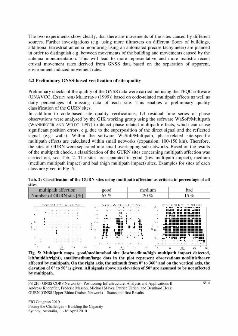
Preliminary checks of the quality of the GNSS data were carried out using the TEQC software (UNAVCO, ESTEY AND MEERTENS (1999)) based on code-related multipath effects as well as daily percentages of missing data of each site. This enables a preliminary quality classification of the GURN sites. In addition to code-based site quality verifications, L3 residual time series of phase observations were analysed by the GIK working group using the software WaSoft/Multipath (WANNINGER AND WILDT 1997) to detect phase-related multipath effects, which can cause significant position errors, e.g. due to the superposition of the direct signal and the reflected signal (e.g. walls). Within the software WaSoft/Multipath, phase-related site-specific multipath effects are calculated within small networks (expansion: 100-150 km). Therefore, the sites of GURN were separated into small overlapping sub-networks. Based on the results of the multipath check, a classification of the GURN sites concerning multipath affection was carried out, see Tab. 2. The sites are separated in good (low multipath impact), medium (medium multipath impact) and bad (high multipath impact) sites. Examples for sites of each class are given in Fig. 5. Tab. 2: Classification of the GURN sites using multipath affection as criteria in percentage of all
sites
multipath affection good medium bad Number of GURN sits [%] 65 % 20 % 15 %
Fig. 5: Multipath maps, good/medium/bad site (low/medium/high multipath impact detected,
left/middle/right), small/medium/large dots in the plot represent observations not/little/heavy
affected by multipath. On the right axis, the azimuth from 0° to 360° and on the vertical axis, the
elevation of 0° to 50° is given. All signals above an elevation of 50° are assumed to be not affected
by multipath.
FS 2H - GNSS CORS Networks - Positioning Infrastructure, Analysis and Applications II Andreas Knoepfler, Frederic Masson, Michael Mayer, Patrice Ulrich, and Bernhard Heck GURN (GNSS Upper Rhine Graben Network) – Status and first Results FIG Congress 2010 Facing the Challenges – Building the Capacity Sydney, Australia, 11-16 April 2010
7/14
Starting as a cooperation with SAPOS® Baden-Württemberg in 2004, yearly multipath
analyses are carried out at the GIK. This enables also – besides determination of the multipath affection of GURN sites – to realise modifications which affect GNSS results (e.g. constructional modifications in the vicinity of the site), in order to avoid pseudo-deformations due to propagation of the effects of the modifications into coordinate time series. In addition, an extended SNR-based stochastic model will be used in the future, in order to reduce the effect of standard GNSS observation weighting on coordinate determination of multipath affected sites (LUO ET AL. 2008). In addition to the above mentioned quality checks, the GNSS data is routinely checked by the GIK working group using the PPP (Precise Point Positioning) module of the Bernese GPS Software (DACH ET AL. 2007). This enables the generation of preliminary time series of all GURN sites independently from data of neighbouring sites. This leads to an improvement of the quality classification, e. g. by means of analysing of scattering of PPP time series. 4.3 On the way to highly precise daily GURN solutions
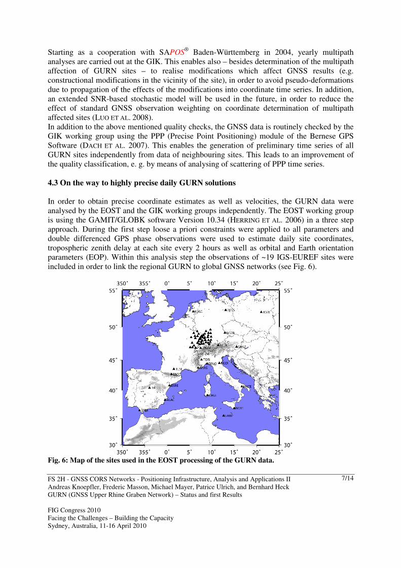
In order to obtain precise coordinate estimates as well as velocities, the GURN data were analysed by the EOST and the GIK working groups independently. The EOST working group is using the GAMIT/GLOBK software Version 10.34 (HERRING ET AL. 2006) in a three step approach. During the first step loose a priori constraints were applied to all parameters and double differenced GPS phase observations were used to estimate daily site coordinates, tropospheric zenith delay at each site every 2 hours as well as orbital and Earth orientation parameters (EOP). Within this analysis step the observations of ~19 IGS-EUREF sites were included in order to link the regional GURN to global GNSS networks (see Fig. 6).
Fig. 6: Map of the sites used in the EOST processing of the GURN data.
FS 2H - GNSS CORS Networks - Positioning Infrastructure, Analysis and Applications II Andreas Knoepfler, Frederic Masson, Michael Mayer, Patrice Ulrich, and Bernhard Heck GURN (GNSS Upper Rhine Graben Network) – Status and first Results FIG Congress 2010 Facing the Challenges – Building the Capacity Sydney, Australia, 11-16 April 2010
8/14
In the second step, a consistent set of coordinates and velocities is estimated using daily loosely constrained estimates of site coordinates, orbits, and EOP as well as their precision information (covariance matrix) as quasi-observations in a Kalman filter. In a third step, generalised constraints (DONG ET AL. 1998) were applied while estimating a six-parameter transformation (rate of change of translation and rotation). To derive velocities of GURN sites relative to the stable Eurasia, the trend of the Eurasian plate defined by ALTAMIMI ET AL. (2002) is removed from the resulting velocity field in the ITRF2000 reference frame.
−20
−10
0
10
20
(mm
)
2004 2006 2008−20
−10
0
10
20
(mm
)
2004 2006 2008−20
−10
0
10
20
(mm
)
2004 2006 2008
KARL North Offset 5455906.848 m
−20
−10
0
10
20
(mm
)
2004 2006 2008−20
−10
0
10
20
(mm
)
2004 2006 2008−20
−10
0
10
20
(mm
)
2004 2006 2008
KARL East Offset 614161.615 m
−20
−10
0
10
20
(mm
)
2004 2006 2008−20
−10
0
10
20
(mm
)
2004 2006 2008−20
−10
0
10
20
(mm
)
2004 2006 2008
KARL Up Offset 182.910 m
−20
−10
0
10
20
(mm
)
2004 2006 2008−20
−10
0
10
20
(mm
)
2004 2006 2008−20
−10
0
10
20
(mm
)
2004 2006 2008
WELS North Offset 5389552.121 m
−20
−10
0
10
20
(mm
)
2004 2006 2008−20
−10
0
10
20
(mm
)
2004 2006 2008−20
−10
0
10
20
(mm
)
2004 2006 2008
WELS East Offset 543161.890 m
−20
−10
0
10
20
(mm
)
2004 2006 2008−20
−10
0
10
20
(mm
)
2004 2006 2008−20
−10
0
10
20
(mm
)
2004 2006 2008
WELS Up Offset 819.086 m
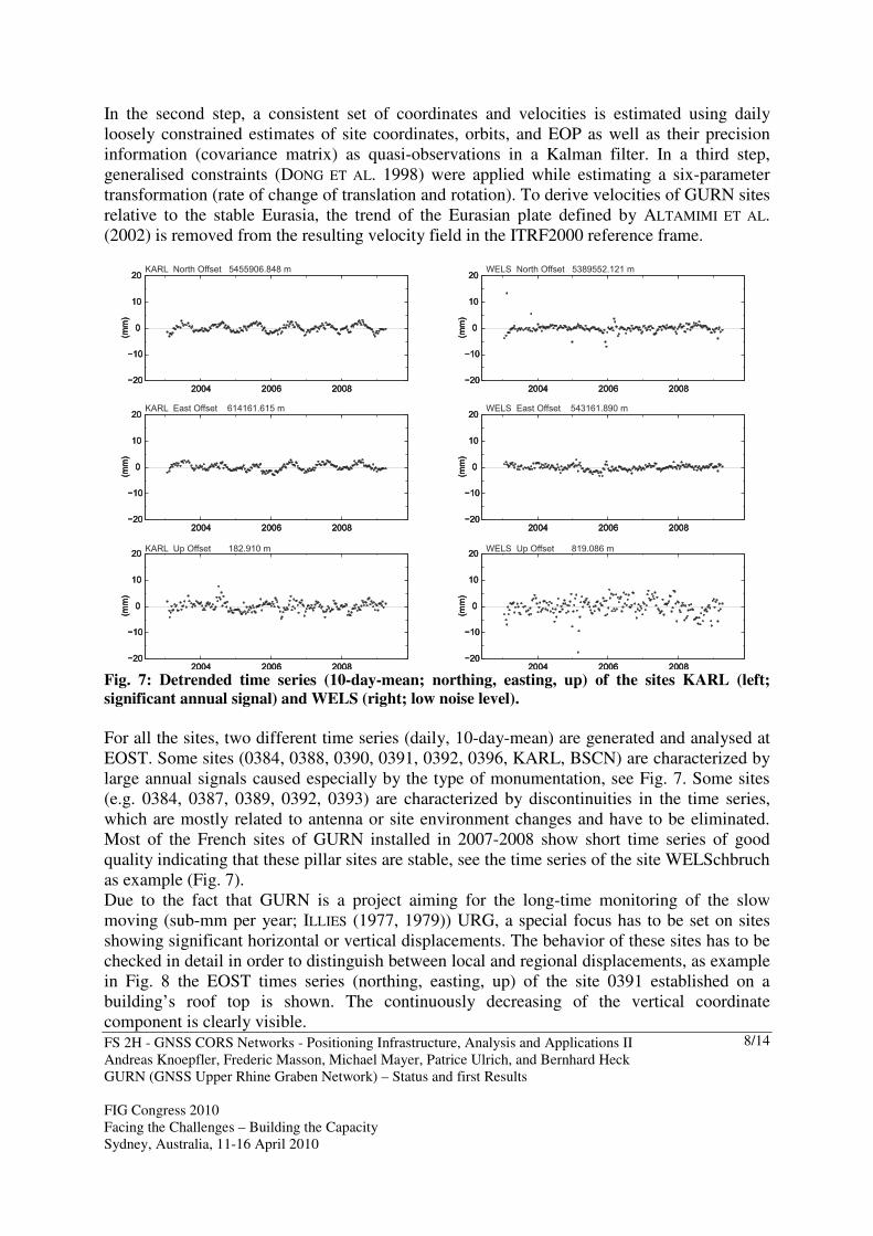
Fig. 7: Detrended time series (10-day-mean; northing, easting, up) of the sites KARL (left;
significant annual signal) and WELS (right; low noise level).
For all the sites, two different time series (daily, 10-day-mean) are generated and analysed at EOST. Some sites (0384, 0388, 0390, 0391, 0392, 0396, KARL, BSCN) are characterized by large annual signals caused especially by the type of monumentation, see Fig. 7. Some sites (e.g. 0384, 0387, 0389, 0392, 0393) are characterized by discontinuities in the time series, which are mostly related to antenna or site environment changes and have to be eliminated. Most of the French sites of GURN installed in 2007-2008 show short time series of good quality indicating that these pillar sites are stable, see the time series of the site WELSchbruch as example (Fig. 7). Due to the fact that GURN is a project aiming for the long-time monitoring of the slow moving (sub-mm per year; ILLIES (1977, 1979)) URG, a special focus has to be set on sites showing significant horizontal or vertical displacements. The behavior of these sites has to be checked in detail in order to distinguish between local and regional displacements, as example in Fig. 8 the EOST times series (northing, easting, up) of the site 0391 established on a building’s roof top is shown. The continuously decreasing of the vertical coordinate component is clearly visible.
FS 2H - GNSS CORS Networks - Positioning Infrastructure, Analysis and Applications II Andreas Knoepfler, Frederic Masson, Michael Mayer, Patrice Ulrich, and Bernhard Heck GURN (GNSS Upper Rhine Graben Network) – Status and first Results FIG Congress 2010 Facing the Challenges – Building the Capacity Sydney, Australia, 11-16 April 2010
9/14
−20
−10
0
10
20(m
m)
−20
−10
0
10
20(m
m)
−20
−10
0
10
20(m
m)
2004 2006 2008
0391 North Offset 5408535.569 m
−20
−10
0
10
20
(mm
)
−20
−10
0
10
20
(mm
)
−20
−10
0
10
20
(mm
)
2004 2006 2008
0391 East Offset 721811.743 m
−20
−10
0
10
20
(mm
)
−20
−10
0
10
20
(mm
)
−20
−10
0
10
20
(mm
)
2004 2006 2008
0391 Up Offset 736.363 m
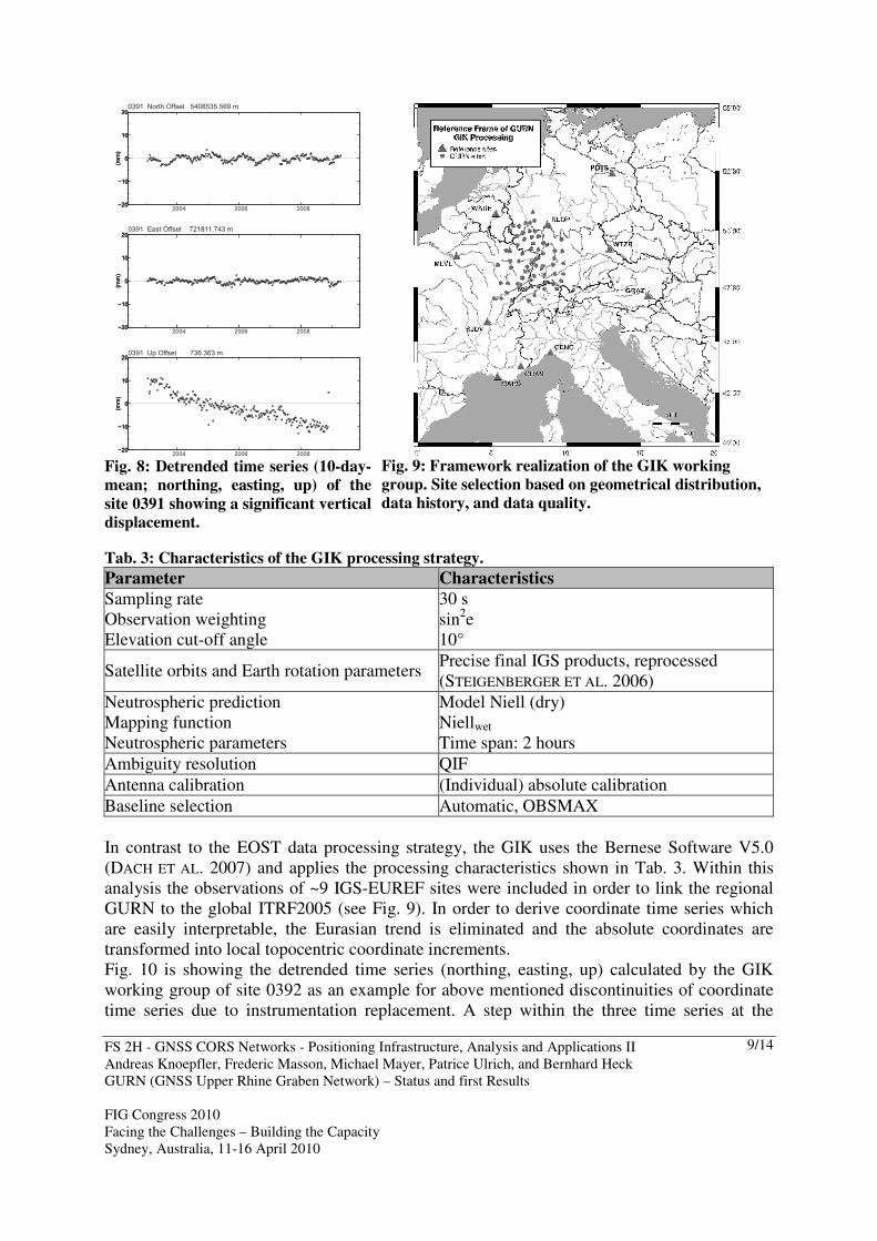
Fig. 8: Detrended time series (10-day-
mean; northing, easting, up) of the
site 0391 showing a significant vertical
displacement.
Fig. 9: Framework realization of the GIK working
group. Site selection based on geometrical distribution,
data history, and data quality.
Tab. 3: Characteristics of the GIK processing strategy.
Parameter Characteristics
Sampling rate Observation weighting Elevation cut-off angle
30 s sin2e
10°
Satellite orbits and Earth rotation parameters Precise final IGS products, reprocessed (STEIGENBERGER ET AL. 2006)
Neutrospheric prediction Mapping function Neutrospheric parameters
Model Niell (dry) Niellwet Time span: 2 hours
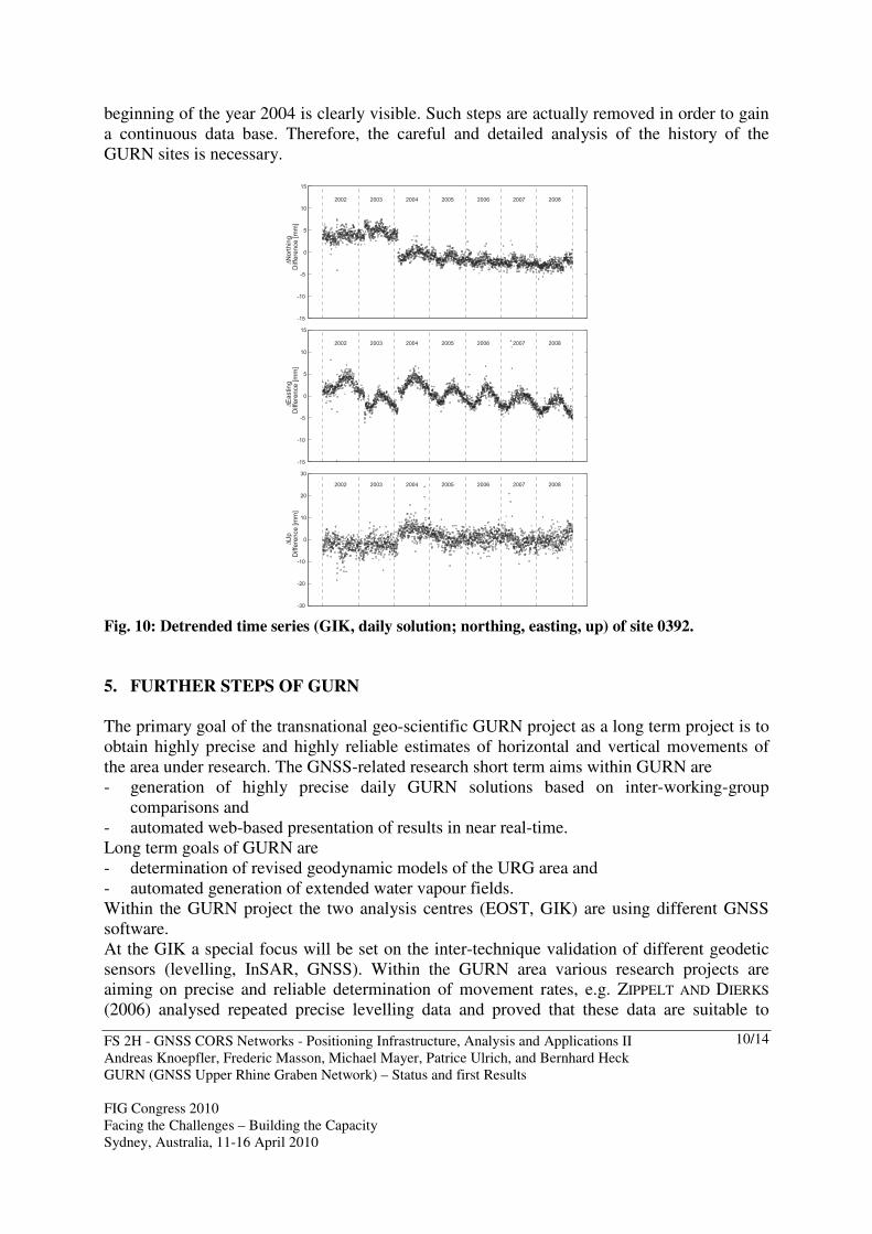
Ambiguity resolution QIF Antenna calibration (Individual) absolute calibration Baseline selection Automatic, OBSMAX In contrast to the EOST data processing strategy, the GIK uses the Bernese Software V5.0 (DACH ET AL. 2007) and applies the processing characteristics shown in Tab. 3. Within this analysis the observations of ~9 IGS-EUREF sites were included in order to link the regional GURN to the global ITRF2005 (see Fig. 9). In order to derive coordinate time series which are easily interpretable, the Eurasian trend is eliminated and the absolute coordinates are transformed into local topocentric coordinate increments. Fig. 10 is showing the detrended time series (northing, easting, up) calculated by the GIK working group of site 0392 as an example for above mentioned discontinuities of coordinate time series due to instrumentation replacement. A step within the three time series at the
FS 2H - GNSS CORS Networks - Positioning Infrastructure, Analysis and Applications II Andreas Knoepfler, Frederic Masson, Michael Mayer, Patrice Ulrich, and Bernhard Heck GURN (GNSS Upper Rhine Graben Network) – Status and first Results FIG Congress 2010 Facing the Challenges – Building the Capacity Sydney, Australia, 11-16 April 2010
10/14
beginning of the year 2004 is clearly visible. Such steps are actually removed in order to gain a continuous data base. Therefore, the careful and detailed analysis of the history of the GURN sites is necessary.
-15
-10
-5
0
5
10
15
2002 2003 2004 2005 2006 2007 2008
∆N
ort
hin
gD
iffe
rence [m
m]
-15
-10
-5
0
5
10
15
2002 2003 2004 2005 2006 2007 2008
∆E
asting
Diffe
rence [m
m]
-30
-20
-10
0
10
20
30
2002 2003 2004 2005 2006 2007 2008
∆U
pD
iffe
rence [m
m]
Fig. 10: Detrended time series (GIK, daily solution; northing, easting, up) of site 0392.
5. FURTHER STEPS OF GURN
The primary goal of the transnational geo-scientific GURN project as a long term project is to obtain highly precise and highly reliable estimates of horizontal and vertical movements of the area under research. The GNSS-related research short term aims within GURN are - generation of highly precise daily GURN solutions based on inter-working-group
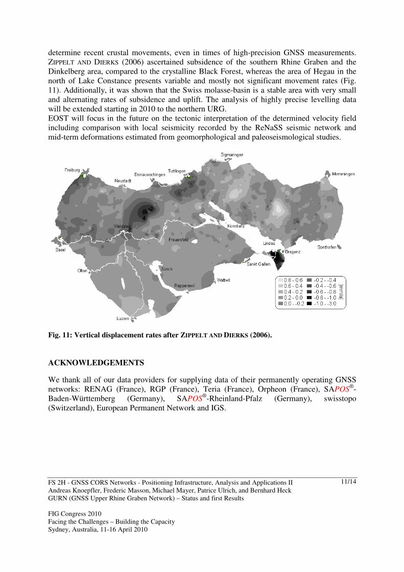
comparisons and - automated web-based presentation of results in near real-time. Long term goals of GURN are - determination of revised geodynamic models of the URG area and - automated generation of extended water vapour fields. Within the GURN project the two analysis centres (EOST, GIK) are using different GNSS software. At the GIK a special focus will be set on the inter-technique validation of different geodetic sensors (levelling, InSAR, GNSS). Within the GURN area various research projects are aiming on precise and reliable determination of movement rates, e.g. ZIPPELT AND DIERKS (2006) analysed repeated precise levelling data and proved that these data are suitable to
FS 2H - GNSS CORS Networks - Positioning Infrastructure, Analysis and Applications II Andreas Knoepfler, Frederic Masson, Michael Mayer, Patrice Ulrich, and Bernhard Heck GURN (GNSS Upper Rhine Graben Network) – Status and first Results FIG Congress 2010 Facing the Challenges – Building the Capacity Sydney, Australia, 11-16 April 2010
11/14
determine recent crustal movements, even in times of high-precision GNSS measurements. ZIPPELT AND DIERKS (2006) ascertained subsidence of the southern Rhine Graben and the Dinkelberg area, compared to the crystalline Black Forest, whereas the area of Hegau in the north of Lake Constance presents variable and mostly not significant movement rates (Fig. 11). Additionally, it was shown that the Swiss molasse-basin is a stable area with very small and alternating rates of subsidence and uplift. The analysis of highly precise levelling data will be extended starting in 2010 to the northern URG. EOST will focus in the future on the tectonic interpretation of the determined velocity field including comparison with local seismicity recorded by the ReNaSS seismic network and mid-term deformations estimated from geomorphological and paleoseismological studies.
Fig. 11: Vertical displacement rates after ZIPPELT AND DIERKS (2006). ACKNOWLEDGEMENTS We thank all of our data providers for supplying data of their permanently operating GNSS networks: RENAG (France), RGP (France), Teria (France), Orpheon (France), SAPOS
®-Baden-Württemberg (Germany), SAPOS
®-Rheinland-Pfalz (Germany), swisstopo (Switzerland), European Permanent Network and IGS.
FS 2H - GNSS CORS Networks - Positioning Infrastructure, Analysis and Applications II Andreas Knoepfler, Frederic Masson, Michael Mayer, Patrice Ulrich, and Bernhard Heck GURN (GNSS Upper Rhine Graben Network) – Status and first Results FIG Congress 2010 Facing the Challenges – Building the Capacity Sydney, Australia, 11-16 April 2010
12/14
REFERENCES ALTAMIMI, Z., P. SILLARD, AND C. BOUCHER (2002). ITRF2000: A new release of the
International Terrestrial Reference Frame for earth science applications. Journal of
Geophysical Research, 107(B10), 2214, doi:10.1029/2001JB000561. BEHRMANN, J., P. ZIEGLER, S. SCHMID, B. HECK, AND M. GRANET (2005). The EUCOR-
URGENT Project. Int. J. Earth Sciences (Geol. Rundschau), 94(4), 505-506. BOURGEOIS, O., M. FORD, M. DIRAISON, C. LE CARLIER DE VESLUD, M. GERBAULT, R. PIK, N.
RUBY, AND S. BONNET (2007). Separation of rifting and lithospheric folding signatures in the NW-Alpine foreland. Int. J. Earth Sciences (Geol. Rundschau), 96, 1003-1031. DOI: 10.1007/s00531-007-0202-2.
BRUYNINX C. (2004). The EUREF Permanent Network: a multi-disciplinary network serving surveyors as well as scientists. GeoInformatics, 7, 32-35.
CLOETINGH, S.A.P.L., P.A. ZIEGLER, P.J.F. BOGAARD, P.A.M. ANDRIESSEN, I.M. ARTEMIEVA, G. BADA, R.T. VAN BALEN, F. BEEKMAN, Z. BEN-AVRAHAM, J.-P. BRUN, H.P. BUNGE, E.B. BUROV, R. CARBONELL, C. FACENNA, A. FRIEDRICH, J. GALLART, A.G. GREEN, O. HEIDBACH, A.G. JONES, L. MATENCO, J. MOSAR, O. ONCKEN, C. PASCAL, G. PETERS, S. SLIAUPA, A. SOESOO, W. SPAKMAN, R.A. STEPHENSON, H. THYBO, T. TORSVIK, G. DE
VICENTE, F. WENZEL, M.J.R. WORTEL and TOPO-EUROPE Working Group (2007). TOPO-EUROPE: The geoscience of coupled deep Earth-surface processes. Global and
Planetary Change, 58(1-4), 1-118. doi:10.1016/j.gloplacha.2007.02.008 DACH, R., U. HUGENTOBLER, P. FRIDEZ, AND M. MEINDL (2007). Bernese GPS Software
Version 5.0. User Manual of the Bernese GPS Software Version 5.0. DONG, D., T.A. HERRING, AND R.W. KING (1998). Estimating regional deformation from a
combination of space and terrestrial geodetic data. Journal of Geodesy, 72, 200-214. DOW, J.M., R.E. NEILAN, AND G. GENDT (2005). The International GPS Service (IGS):
Celebrating the 10th Anniversary and Looking to the Next Decade. Adv. Space Res., 36, 320-326. doi:10.1016/j.asr.2005.05.125
ESTEY, L.H. AND C.M. MEERTENS (1999). TEQC: The Multi-Purpose Toolkit for GPS/GLONASS Data. GPS Solutions, 3(1), 42-49.
GAUDET A. AND J.C. LANDRY (2005). TERIA: The GNSS Network for France. Proceedings, From Pharaohs to Geoinformatics, FIG Working Week 2005 and GSDI-8, April 16th-21th 2005, Cairo, Egypt. Link: http://www.fig.net/pub/cairo/papers/ts_08/ ts08_03_gaudet_landry.pdf.
HERRING T., B. KING, AND S. MCCLUSKY (2006). Introduction to GAMIT/GLOBK. Reference manual. Global Kalman filter VLBI and GPS analysis program. Release 10.3. EAPS, MIT.
ILLIES, J.H. (1977). Ancient and recent rifting in the Rhine graben. Geologie en Mijbouw, 56, 320-350.
ILLIES, J.H. (1979). Rhinegraben: Shear controlled vertical motions of the graben floor. Allgemeine Vermessungs-Nachrichten, 86, 364-367.
LUO. X., M. MAYER, B. HECK (2008). Improving the Stochastic Model of GNSS Observations by Means of SNR-based Weighting. In: SIDERIS, M.G. (Hrsg.): Observing our Changing
Earth. Proceedings of the 2007 IAG General Assembly, Perugia, Italy, July 2 - 13, 2007, Springer Series: IAG Symposia, Vol. 133, Springer Verlag, Berlin Heidelberg 2008, 725-734.
FS 2H - GNSS CORS Networks - Positioning Infrastructure, Analysis and Applications II Andreas Knoepfler, Frederic Masson, Michael Mayer, Patrice Ulrich, and Bernhard Heck GURN (GNSS Upper Rhine Graben Network) – Status and first Results FIG Congress 2010 Facing the Challenges – Building the Capacity Sydney, Australia, 11-16 April 2010
13/14
LUO, X. AND M. MAYER (2008). Automatisiertes GNSS-basiertes Bewegungsmonitoring am Black Forest Observatory (BFO) in Nahezu-Echtzeit. Zeitschrift für Geodäsie,
Geoinformatik und Landmanagement (ZfV), 133(6), 283-294. MEGHRAOUI, M., B. DELOUIS, M. FERRY, D. GIARDINI, P. HUGGENBERGER, I. SPOTKE, AND M.
GRANET (2001). Active normal faulting in the Upper Rine Graben and paleoseismic identification of the 1356 Basel earthquake. Science, 293, 2070-2073.
STEIGENBERGER, P, M. ROTHACHER, R. DIETRICH, M. FRITSCHE, A. RÜLKE, AND S. VEY (2006). Reprocessing of a global GPS network. Journal of Geophysical Research, 111, B05402. doi 10.1029/2005JB003747.
ROZSA, S., M. MAYER, M. WESTERHAUS, K. SEITZ, AND B. HECK (2005a).Towards the determination of displacements in the Upper Rhine Graben area using GPS measurements and precise antenna modelling. Quaternary Science Reviews, 24,425-438.
ROZSA, S., B. HECK, M. MAYER, K. SEITZ, M. WESTERHAUS, AND K. ZIPPELT (2005b). Determination of Displacements in the Upper Rhine Graben Area from GPS and Leveling Data. Int. J. Earth Sci, 94, 538-549.
WANNINGER, L. AND S. WILDT (1997). Identifikation von Mehrwegeeinflüssen in GPS-Referenzstationsbeobachtungen. Allgemeine VermessungsNachrichten, 104, 12-17.
WEGENER, V. AND M. STRONK (2005). SAPOS®- A Satellite Positioning Service of the
German State Survey. GeoInformatics, 8, 40-43. ZIEGLER, P.A. (1992). European Cenozoic Rift System. Tectonophysics, 208, 91-111. ZIPPELT, K. AND O. DIERKS (2006). Auswertung von wiederholten Präzisionsnivellements im
südlichen Schwarzwald, Bodenseeraum sowie in angrenzenden schweizerischen Landesteilen. NAGRA, NAB 07-27.
BIOGRAPHICAL NOTES
Dipl.-Ing. Andreas Knoepfler received his diploma of Karlsruhe University (TH) in 2005. From 2005 to 2007 he worked in the subproject "Recent plate kinematics in Romania" of the Collaborative Research Center 461 "Strong Earthquakes" dealing with the detection of plate kinematics by means of GPS campaign measurements. He is a member of the GNSS working group of Prof. Heck. His actual research focus is on the detection of geodynamics in the area of the Upper Rhine Graben by means of permanent GNSS observations. Dr.-Ing. Michael Mayer received his doctoral degree in 2005 from the Karlsruhe University (TH), when he was researching the appropriate modeling of the deformation network Antarctic Peninsula. He is actually head of the GNSS working group of the chair of Prof. B. Heck. He is interested in mitigation of atmospheric and site-specific GNSS effects with a special focus on continuously operated reference sites. Prof. Dr.-Ing. Dr.h.c. Bernhard Heck holds the chair of Physical and Satellite Geodesy at Karlsruhe Institute of Technology (KIT) in Karlsruhe/Germany. He received the PhD degree in 1979 from the Karlsruhe University and worked in the fields of geometrical geodesy, deformation analysis, gravity field analysis, and GNSS positioning. In addition, he is director of the Black Forest Observatory (BFO).
FS 2H - GNSS CORS Networks - Positioning Infrastructure, Analysis and Applications II Andreas Knoepfler, Frederic Masson, Michael Mayer, Patrice Ulrich, and Bernhard Heck GURN (GNSS Upper Rhine Graben Network) – Status and first Results FIG Congress 2010 Facing the Challenges – Building the Capacity Sydney, Australia, 11-16 April 2010
14/14
Prof. Frederic Masson is head of the geodetic observatory of the Strasbourg University. He is interested in the use of geodetic data to determine the strain in tectonic active zones (mainly the Alpine-Himalayan region). Patrice Ulrich is engineer at the geodetic observatory of the Strasbourg, in charge of the installation and the good health of the French cGPS stations. He also manages the GURN data base.
CONTACTS Dipl.-Ing. Andreas Knoepfler Geodetic Institute, Karlsruhe Institute of Technology (KIT) Englerstr. 7, D-76131 Karlsruhe Karlsruhe GERMANY Tel. ++49 / 721 / 608 2303 Fax ++49 / 721 / 608 6552 Email: [email protected] Web site: www.gik.uni-karlsruhe.de/gurn.html