Embed Size (px)
Citation preview
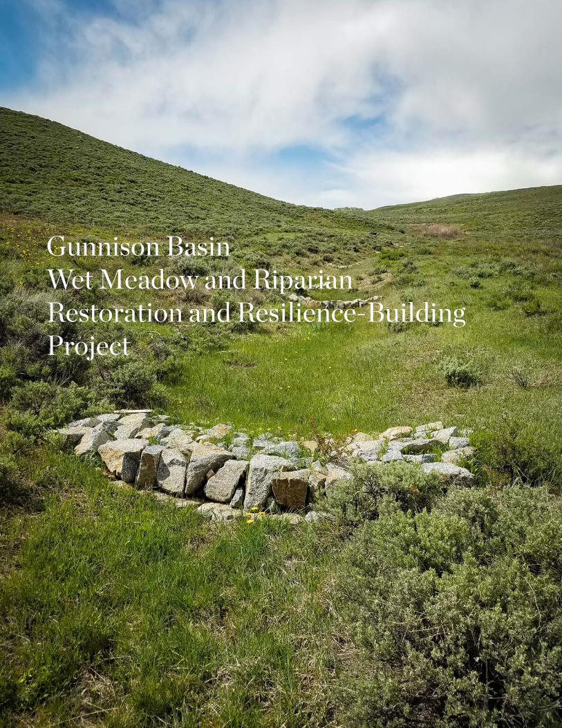
Gunnison Basin Wet Meadow and Riparian Restoration and Resilience-Building Project
1. CRITICAL WILDLIFE HABITATWet meadows and riparian areas occupy a small proportion of the sagebrush ecosystem in the Gunnison Basin, yet provide critically important habitat for many species. These mesic areas, in an otherwise semi-arid climate, are vital to the life cycle of the federally threatened Gunnison sage-grouse, providing important brood-rearing habitat for the grouse to raise their young chicks. These meadows also provide important food and cover for insects, pollinators, neo-tropical migratory birds, mule deer, elk, and forage for domestic livestock.
Wet meadows and riparian areas also serve as natural sponges to hold water in the soil, slowly releasing it after runoff events, ensuring continued base flows and maintenance of water tables throughout the growing season. Holding water in these systems later into the summer season and during droughts benefits plants, wildlife, and ranchers.
2. THREATS TO RESOURCESMany riparian areas and wet meadows in the Gunnison Basin have been degraded by erosion and past land uses, resulting in incised gullies and lowered water tables. Intense episodic droughts, such as the one in 2002, have exacerbated these problems. As our temperatures continue to rise, droughts and intense runoff events that increase erosion are likely to become more frequent. If these already uncommon habitats degrade further, the many plants and animals that depend on them will suffer, including the Gunnison sage-grouse. Since only about 5,000 of these birds remain in the world, they cannot withstand more loss of this important habitat. Degraded riparian areas and wet meadows also pose challenges to ranchers, who are already experiencing other pressures. To help both wildlife and ranchers, we need to restore these habitats and make them better able to withstand change.
“This is the most gratifying project I have worked on as a consultant because of the cooperation of so many people, including NGOs, agencies, and private landowners.”
– Bill Zeedyk, pictured above on the left, is a nationally recognized restoration expert who has worked on over 300 projects across the southwestern US.
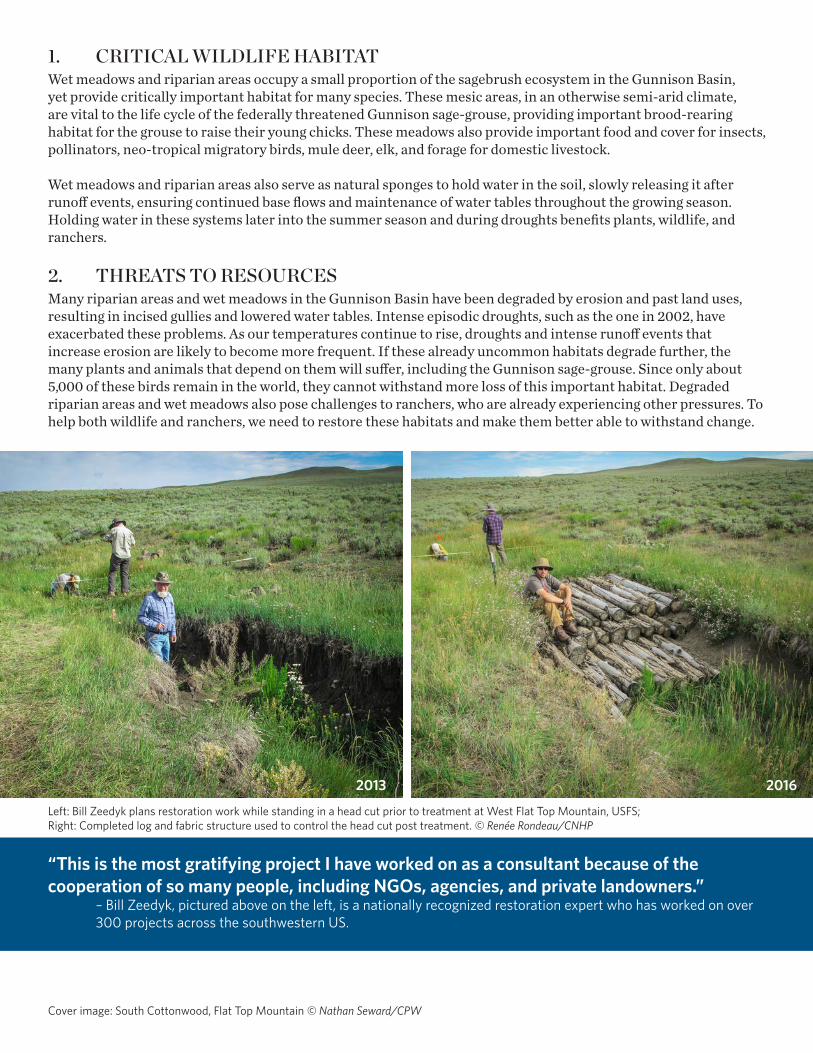
Left: Bill Zeedyk plans restoration work while standing in a head cut prior to treatment at West Flat Top Mountain, USFS; Right: Completed log and fabric structure used to control the head cut post treatment. © Renée Rondeau/CNHP
Cover image: South Cottonwood, Flat Top Mountain © Nathan Seward/CPW
2013 2016
3. ENHANCING ECOSYSTEM RESILIENCE To address these challenges, the Gunnison Climate Working Group (GCWG), a public-private partnership preparing for change in the Gunnison Basin, has been working since 2012 to enhance ecosystem resilience of riparian areas and wet meadows by restoring their hydrologic and ecological function. The group uses a variety of restoration techniques to help slow down water during flow events, raise water tables, reduce erosion, stabilize head cuts, reduce impacts of wildlife and cattle trailing, reconnect channels to floodplains, and increase cover of wetland plants.
Vision:Natural wet meadows and riparian habitats within the sagebrush landscape of the Gunnison Basin are resilient and support a sustaining population of Gunnison sage-grouse and other species, biological communities, ecosystem services and livelihoods in the face of a changing climate. Sustained and long-term community commitment to stewardship of wet meadows and riparian areas helps nature and people adapt to climate change.
Objectives:1. Increase ecosystem resilience by restoring
hydrologic function of wet meadow and riparian habitats at a scale large enough to help the Gunnison sage-grouse, other sagebrush dependent wildlife and ranchers who depend on these habitats for their livelihoods.
2. Build a sustainable and enduring program to increase restoration across the Basin.
3. Ensure scientific rigor of this project through a long-term monitoring program.
4. Develop and evaluate cost-effective tools, methods, and planning to help scale up the project.
5. Share best practices and lessons learned to encourage application of methods within and outside the Basin, particularly in Gunnison and Greater sage-grouse habitats in the West.
4. COLLABORATION AND COMMUNITY ENGAGEMENTThe collaboration of local, state and federal agencies, non-governmental organizations, universities, ranchers and volunteers has been essential in achieving watershed-scale restoration across land management boundaries. This is the type of collaboration that is needed to effectively prepare nature and people for an uncertain future.
The local ranchers that have been engaged recognize that the restoration techniques are improving forage for livestock and helping keep water on the land for a longer time during the growing season. On one private ranch after a year of restoration, the rancher said: “This is the most important project we’ve done for the Gunnison sage-grouse.”
Matt Vasquez, Wildlife Biologist for the USDA Forest Service, Gunnison Ranger District, stated: “Using a holistic-based collaborative approach, this project has unequivocally engaged the Gunnison community on a shared passion to build resiliency and enhance ecosystem services. This shared passion for the natural resources we all depend on has been immensely gratifying and inspiring to be a part of.”
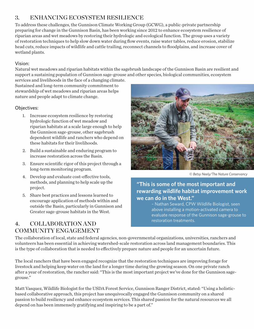
“This is some of the most important and rewarding wildlife habitat improvement work we can do in the West.”
– Nathan Seward, CPW Wildlife Biologist, seen above installing a motion-activated camera to evaluate response of the Gunnison sage-grouse to restoration treatments.
© Betsy Neely/The Nature Conservancy
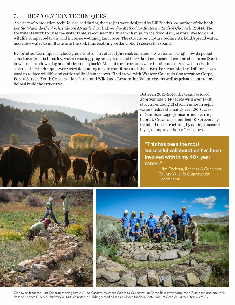
5. RESTORATION TECHNIQUESA variety of restoration techniques used during the project were designed by Bill Zeedyk, co-author of the book, Let the Water do the Work: Induced Meandering: An Evolving Method for Restoring Incised Channels (2014). The treatments work to raise the water table, re-connect the stream channel to the floodplain, restore livestock and wildlife compacted trails, and increase wetland plant cover. The structures capture sediments, hold/spread water, and allow water to infiltrate into the soil, thus enabling wetland plant species to expand.
Restoration techniques include grade control structures (one rock dam and low water crossing), flow dispersal structures (media luna, low water crossing, plug and spread, and filter dam) and headcut control structures (Zuni bowl, rock rundown, log and fabric, and layback). Most of the structures were hand-constructed with rocks, but several other techniques were used depending on site conditions and objectives. For example, the drift fence was used to reduce wildlife and cattle trailing in meadows. Field crews with Western Colorado Conservation Corps, Forest Service Youth Conservation Corps, and Wildlands Restoration Volunteers, as well as private contractors, helped build the structures.
Between 2012-2016, the team restored approximately 140 acres with over 1,000 structures along 21 stream miles in eight watersheds, enhancing over 1,000 acres of Gunnison sage-grouse brood-rearing habitat. Crews also modified 100 previously installed rock structures, by adding a second layer, to improve their effectiveness.
“This has been the most successful collaboration I’ve been involved with in my 40+ year career.”
– Jim Cochran, Rancher & Gunnison County Wildlife Conservation Coordinator
Clockwise from top: Jim Cochran moving cattle © Jaci Cochran, Western Colorado Conservation Corps field crew complete a Zuni bowl and one rock dam at Chance Gulch © Andrew Breibart, Volunteers building a media luna at CPW’s Kaichen State Habitat Area © Claudia Strijek/WSCU
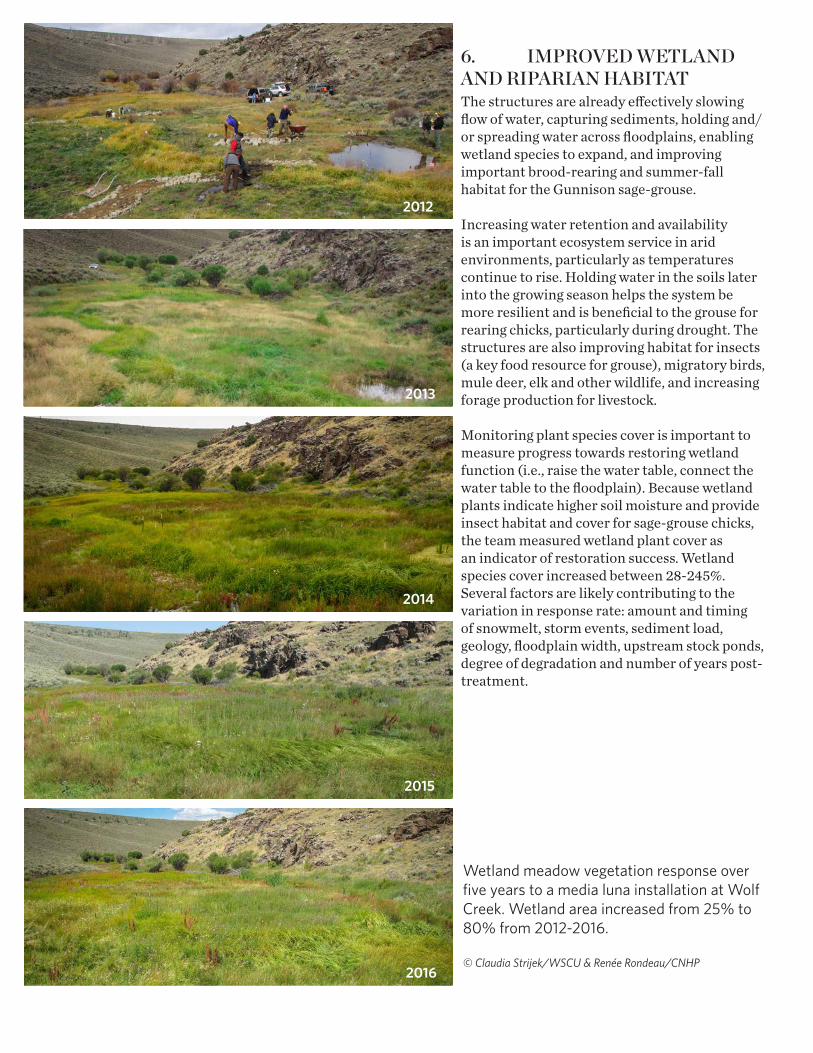
6. IMPROVED WETLAND AND RIPARIAN HABITATThe structures are already effectively slowing flow of water, capturing sediments, holding and/or spreading water across floodplains, enabling wetland species to expand, and improving important brood-rearing and summer-fall habitat for the Gunnison sage-grouse.
Increasing water retention and availability is an important ecosystem service in arid environments, particularly as temperatures continue to rise. Holding water in the soils later into the growing season helps the system be more resilient and is beneficial to the grouse for rearing chicks, particularly during drought. The structures are also improving habitat for insects (a key food resource for grouse), migratory birds, mule deer, elk and other wildlife, and increasing forage production for livestock.
Monitoring plant species cover is important to measure progress towards restoring wetland function (i.e., raise the water table, connect the water table to the floodplain). Because wetland plants indicate higher soil moisture and provide insect habitat and cover for sage-grouse chicks, the team measured wetland plant cover as an indicator of restoration success. Wetland species cover increased between 28-245%. Several factors are likely contributing to the variation in response rate: amount and timing of snowmelt, storm events, sediment load, geology, floodplain width, upstream stock ponds, degree of degradation and number of years post-treatment.
Wetland meadow vegetation response over five years to a media luna installation at Wolf Creek. Wetland area increased from 25% to 80% from 2012-2016.
© Claudia Strijek/WSCU & Renée Rondeau/CNHP
2012
2013
2014
2015
2016
7. BEST PRACTICES AND LESSONS LEARNED It will take many years to build resilience of wet meadows and riparian areas across the Basin and the region, as numerous drainages would benefit from this work. Restoration can be an ongoing task, given that heavy rains and run-off events can rapidly exacerbate erosion and the formation of gullies.
• Collaboration and partner engagement are key to ensuring optimal response when working at the watershed-scale across land ownership and management boundaries. Building trust and establishing credibility with local landowners is essential.
• Restoration treatments need planning and design by restoration experts to ensure effective response. Restoration experts are needed to train and oversee field crews and volunteers in building structures.
• Wetland delineation, permits, agency requirements and landowner agreements should be completed well in advance of work. Consult with the US Fish and Wildlife Service if working within critical habitat of the Gunnison sage-grouse.
• Sharing best practices though trainings with managers and land owners is critical for success and building local capacity.
• Projects require repeat visits to treated stream reaches to monitor effectiveness, determine needs for modification, and maintain structures to ensure long-term success.
• Conducting a climate-informed analysis can identify streams that would benefit from these restoration techniques and can serve as a starting point for field evaluation and prioritization.
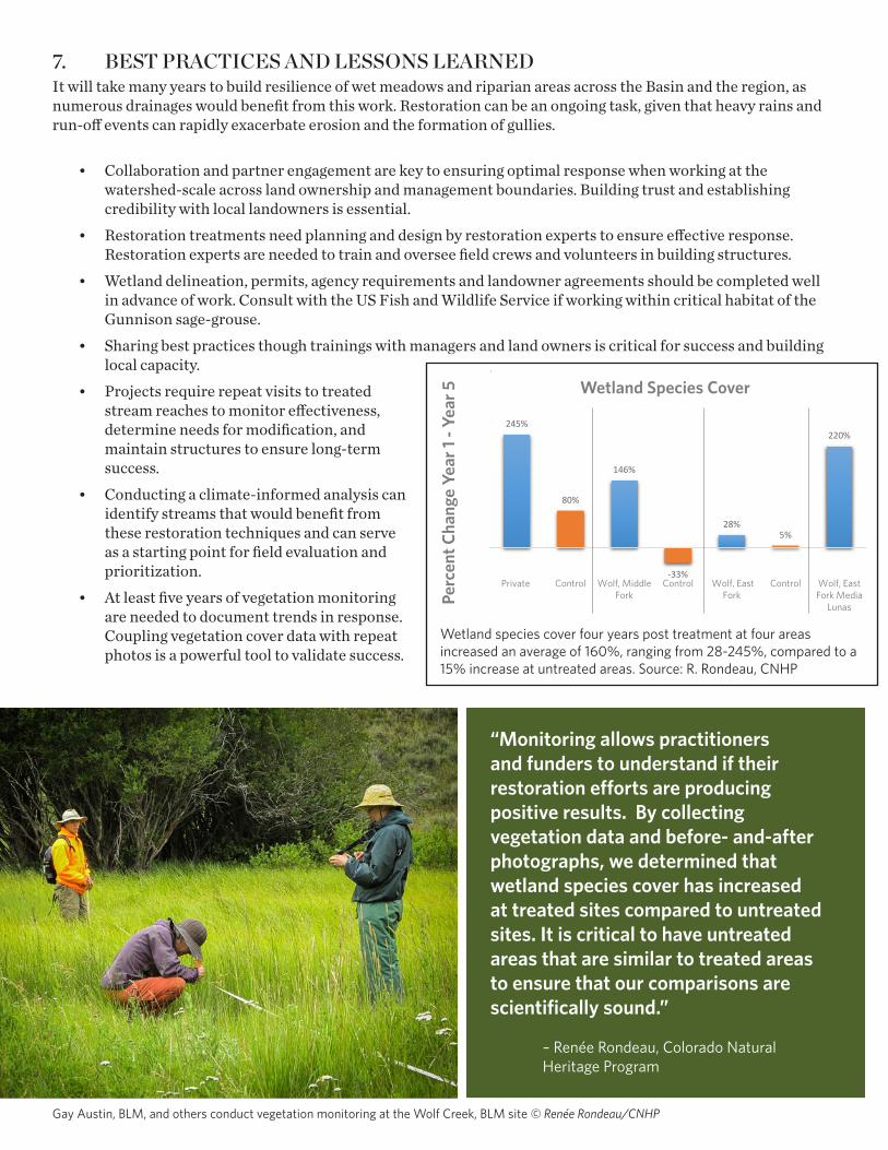
• At least five years of vegetation monitoring are needed to document trends in response. Coupling vegetation cover data with repeat photos is a powerful tool to validate success.
“Monitoring allows practitioners and funders to understand if their restoration efforts are producing positive results. By collecting vegetation data and before- and-after photographs, we determined that wetland species cover has increased at treated sites compared to untreated sites. It is critical to have untreated areas that are similar to treated areas to ensure that our comparisons are scientifically sound.”
– Renée Rondeau, Colorado Natural Heritage Program
Reach Year 1 Year 2 Year 3 Year 4 Year 5
Diff 1st yr vs last year (%)
Four Years Post-StructuresRedden 11% 26% 43% 48% 37% 245%Control 12% 15% 18% 17% 21% 80%Wolf, Midd 15% 28% 26% 33% 37% 146%Control 7% 15% 5% 6% -33% Wolf, East 57% 82% 82% 90% 73% 28%Control 67% 70% 70% 5%Wolf, East 25% 45% 75% 75% 80% 220%
245%
80%
146%
-33%
28%5%
220%
Private Control Wolf, MiddleFork
Control Wolf, EastFork
Control Wolf, EastFork Media
Lunas
Perc
ent C
hang
e Ye
ar1-Y
ear 5
Wetland Species Cover, Four Years Post StructuresWetland Species Cover
Perc
ent C
hang
e Ye
ar 1
- Yea
r 5
Gay Austin, BLM, and others conduct vegetation monitoring at the Wolf Creek, BLM site © Renée Rondeau/CNHP
Wetland species cover four years post treatment at four areas increased an average of 160%, ranging from 28-245%, compared to a 15% increase at untreated areas. Source: R. Rondeau, CNHP
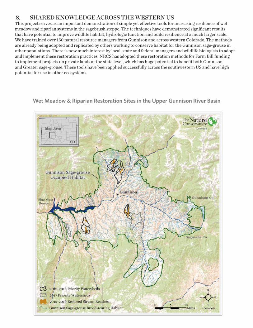
8. SHARED KNOWLEDGE ACROSS THE WESTERN USThis project serves as an important demonstration of simple yet effective tools for increasing resilience of wet meadow and riparian systems in the sagebrush steppe. The techniques have demonstrated significant results that have potential to improve wildlife habitat, hydrologic function and build resilience at a much larger scale. We have trained over 150 natural resource managers from Gunnison and across western Colorado. The methods are already being adopted and replicated by others working to conserve habitat for the Gunnison sage-grouse in other populations. There is now much interest by local, state and federal managers and wildlife biologists to adopt and implement these restoration practices. NRCS has adopted these restoration methods for Farm Bill funding to implement projects on private lands at the state level, which has huge potential to benefit both Gunnison and Greater sage-grouse. These tools have been applied successfully across the southwestern US and have high potential for use in other ecosystems.
Wet Meadow & Riparian Restoration Sites in the Upper Gunnison River Basin
GUNNISON CLIMATE WORKING GROUP PARTNERS & FUNDERSWe thank the many partners for numerous in-kind contributions and generous funding of this project. This project would not have been possible without the cooperating ranchers, landowners and permittees.
• BIO-Logic, Inc.
• Bird Conservancy of the Rockies
• Bureau of Land Management
• Colorado Natural Heritage Program
• Colorado Parks and Wildlife
• Great Outdoors Colorado
• Gunnison County
• Gunnison Conservation District
• National Park Service
• Natural Resources Conservation Service
• Terra Foundation
• The Nature Conservancy
• Upper Gunnison River Water Conservancy District
• USDA Forest Service
• Western Colorado Conservation Corps
• Western State Colorado University
• Western Water Assessment, University of Colorado
• Wildlands Restoration Volunteers
• Wildlife Conservation Society
• Zeedyk Ecological Consulting
For further information about this project, please visit: www.conservationgateway.org and search for Gunnison Basin Reports
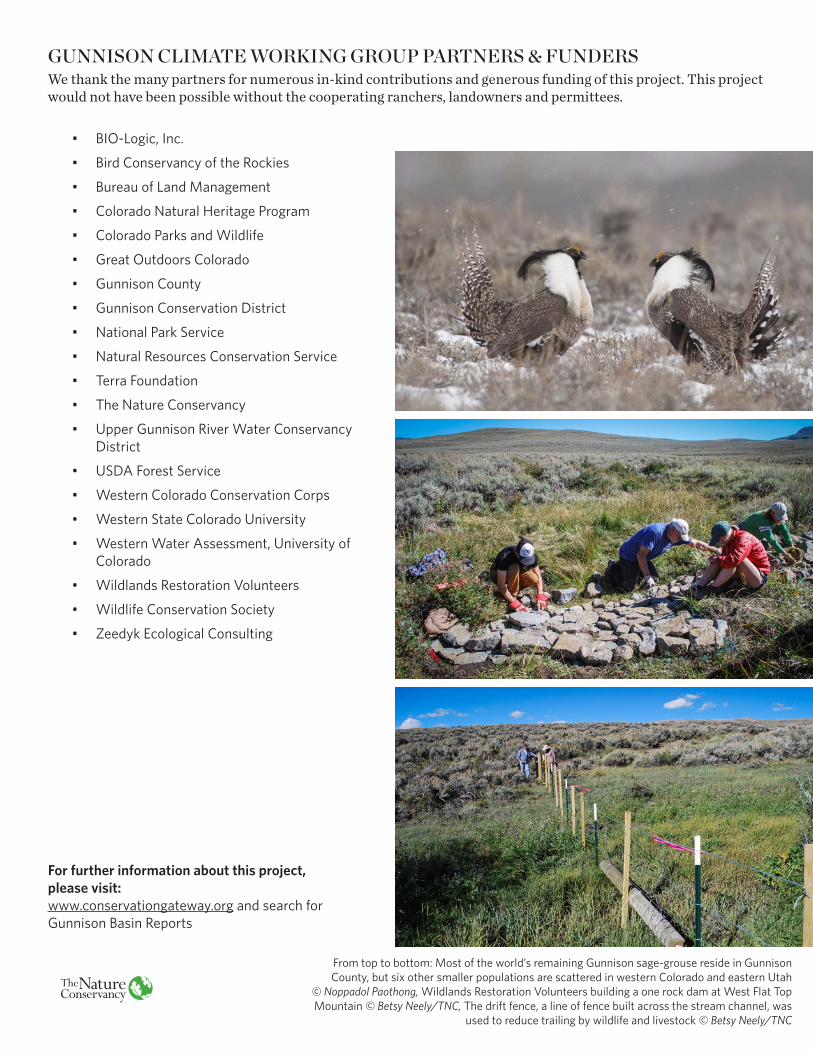
From top to bottom: Most of the world’s remaining Gunnison sage-grouse reside in Gunnison County, but six other smaller populations are scattered in western Colorado and eastern Utah
© Noppadol Paothong, Wildlands Restoration Volunteers building a one rock dam at West Flat Top Mountain © Betsy Neely/TNC, The drift fence, a line of fence built across the stream channel, was
used to reduce trailing by wildlife and livestock © Betsy Neely/TNC