Embed Size (px)
Citation preview
For more information call Parks Victoria on 13 1963
or visit www.parks.vic.gov.au
Healthy Parks Healthy People
Visiting a park can improve your health, mind, body and
soul. So, with over four million hectares of parkland available to Victorians, why not escape
to a park today!
pa
rkn
ote
s
Healthy Parks Healthy People
Visiting a park can improve your health, mind, body and
soul. So, with over four million hectares of parkland available to Victorians, why not escape
to a park today!
Gunbower National Park
Visitor Guide The 8892ha Gunbower National Park is a unique and diverse wonderland of waterbirds, wildlife and aquatic
plants. With a backdrop of the Murray River and majestic River Red Gums, the park is ideal for camping and a
range of water-‐based recreation.
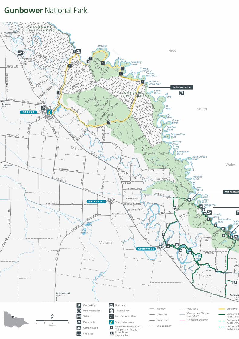
Black Swans – Photo: Paul O’Connor DEPI
River Red Gum forests have high natural, cultural and economic values. These forests are under increasing pressure from climate change, drought and reduced water flows in the northern rivers.
Protecting this precious environment relies on balancing the economic and recreational activities with preserving its natural beauty and values.
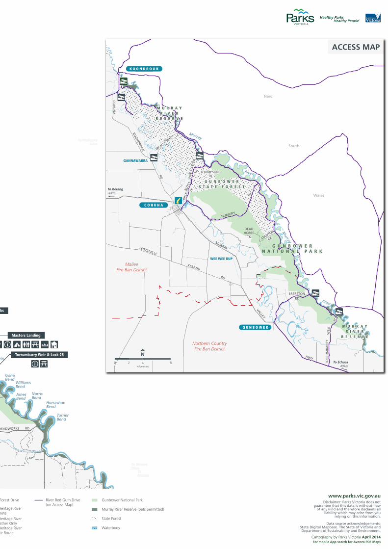
Enjoying the park Walking – A 14km walking track near Koondrook will take you past the Eagle Tree and a number of cultural sites. Contact the Department of Environment and Primary Industries (DEPI) for further information.
Scenic drives – A leisurely half day drive, starting at Cohuna, links a number of historical, cultural and ecological sites (see overleaf).
The River Red Gum Drive is one of Victoria’s Iconic Four Wheel Drives and follows River Track through the park. Information about the drive is available at visitor information centres.
The Gunbower Heritage River Trail is a 35km loop highlighting significant Indigenous and European cultural heritage sites including the Torrumbarry Weir and Masters Landing homestead.
Fishing -‐ The river is a breeding ground for native fish species such as Murray Cod and Golden Perch.
A current NSW Freshwater Recreation Fishing Licence is required for the Murray River. A Victorian Recreational Fishing Licence is required for fishing in waters south of the Murray River.
Camping -‐ Basic bush camping is available along the Murray River and Gunbower Creek on the island.
A designated campsite with toilet facilities is also available downstream from Masters Landing.
Boating and canoeing -‐ The five kilometre canoe trail at Safes Lagoon, near Koondrook in Gunbower State Forest, will take about two hours to complete (return). Bring your own canoe and check water levels and access before you go. See DEPI trail brochure.
Swimming is popular, particularly at the sandy river bend beaches.
Note: Take care when swimming -‐ cold water and fast currents can be hazardous and there may be submerged logs. Diving or jumping into the water can be dangerous.
A rich history Gunbower Island was frequented by two clans -‐ the Barapa Barapa and the Yorta Yorta.
The Barapa Barapa and Yorta Yorta people have long connections with the area now known as Gunbower National Park. The area was known as Kanbowro – twisting and tortuous like the necks of the Black Swans. When exploring you may discover shell middens (kitchen hearths), burial sites and scar trees. These Australian heritage sites are protected by law.
In 1860 Fredrick Masters left Echuca in a rowing boat for Swan Hill, making camp at the site now known as Masters Landing. Fredrick built himself a permanent shelter from the bark of Grey-‐box trees. The house is still standing today, more than 150 years later.
In the 1870s, Paddle Steamers worked up and down the river six or seven months of the year. Goods were off-‐loaded at Masters Landing and taken to Gunbower by horse-‐drawn dray or wagon. Produce was brought to the site for the return trip to Echuca or loaded onto boats headed up the Darling River.
Be fire ready and stay safe On days of forecast Code Red Fire Danger this park will be closed for public safety.
If you are already in the park you should leave the night before or early in the morning for your own safety.
Rangers will patrol where possible, however you may not receive a personal warning that the park is closed so check by calling 13 1963 or visit www.parks.vic.gov.au.
For up to date information on fires in Victoria or general fire safety advice call the Victorian Bushfire Information Line on 1800 240 667 or visit www.emergency.vic.gov.au.
New
South
Wales
Victoria
COH
UN
A
KO
ON
DRO
OK
RD
WEYM
OUTHS RDDICKSONS RD
HUDSONS
TK
CENTRE
BKBARTON
TK
LOG HAULER TK
RIFL
EBU
TTS
TK FIV
ESL
EEPE
R
TK
THOMPSON
TK
WEE
WEE
RUP
TK
WEE
WEE
RUP
TK
GA
RNER
BKCORDUROY
TK
CHETTLE
TK
SWAMP
SMIT
H
TKCEN
TRE
BK
NURSERY
TK
FENCE
TKEAST
ON
SR
D
86
BK86
TK
84TK
NU
RSER
YTK
BART
ON
TK
ROBE
RTSO
N
BK
ROBE
RTSO
N
TK
RIVER
TK
RIVERPETER
CREEK TK
TK
WATT
LETK
RIVER
TK
BRAYS
SPENCESBRIDGERD
RD
CA
RW
AR
DIN
ESR
D
MURRAY VALLEYHWY
MCMILLANS
MC
MIL
LAN
S
RD
MURRAY
VALLEY
PIPE
RS
RD
RA
ND
ALL
SR
DHORNSBYS RD
BOWLANDS RD
KOWSWAMP RD
GR
EEN
S
RD
RD
HW
Y
MU
RRAY
VALLEY
HWY
LEITCHVILLE
KERANG
HILDEBRAND
RD
RD
LEIT
CH
VIL
LE
PYRAMID
RD
PYRA
MID
CO
HU
NA
RD
LEITCH
VILLE
COH
UN
AR
D
COHUNA
ISLAND
RD
DALTONS
RD
BATEMANSBK
DEA
DH
OR
SE TK
STANTONBK
FREES RD
TICKELLS
TK
DEEP CREEK TK
RED
RISE
TK
SCOTTY TK
HEADWORKS RD
MCPHAIL RD
RD
NORMANRD
BAGGOT
CREEKTK
EMU
HOLE
TK
MCGILL
IVRAY
TK
BRERETONRD
MCDONALDS RD
THOMPSONS WEIR
R PEACES RD
RD
FINDLAYS RD
OBRIENS RD
OREILLYS
RD
MUNZEL RD
BA
WD
ENTK
RIVER TK
RIVER
TK
MA
TTH
EWS
RD
GA
MB
LE
TOR
RU
MB
AR
RY
WEIR
RD
DYE RD
TurnerBend
HorseshoeBend
NorrisBend
JonesBend
WilliamsBend
GonaBend
BaldwinBend
Broken RiverBend
WorthyBend
McKay MillBend
DalleyBend
LongBend
BellBend
MopokeBend
Kate MaloneBend
ScottyBend
BonnemanBend
HalfwayBend
SandbarBend
Broken RiverBend
82Bend
GravelBend
SocialBend 86
Bend
84Bend
NurseryBend No.1
NurseryBend No.2
NurseryBend No.3
CemeteryBend
McClureBend
Murray
River
Murray
River
KowSwamp
KowSwamp
G U N B O W E RS T A T E F O R E S T
G U N B O W E RS T A T E F O R E S T
To Echuca
ToPyramid Hill
G U N B O W E RS T A T E F O R E S T
G U N B O W E RS T A T E F O R E S T
To Koondrook20km
To Kerang30km
To Kerang30km
To Pyramid Hill12km To Echuca
33km
C O H U N A
G U N B O W E R
L E I T C H V I L L E
MalleeFire Ban District
Northern CountryFire Ban District
New
South
Wales
CO
HU
NA
KOO
ND
ROO
K
RD
IRON
PUNT
TK
NURSERY
TK
STANTON
BK
BRERETONRD
MURRAY
VALLEY
HWY
LEITCHVILLE
KERANG
RD
DEADHORSE
TK
RD
TOR
RU
MB
AR
RY
W
EIR
RIFL
EBU
TTS
TKFI
VE
SLEE
PER
TK THOMPSONSTK
GANNAWARRA
WEE WEE RUP
G U N B O W E RS T A T E F O R E S T
M U R R A YR I V E R
R E S E R V E
M U R R A YR I V E R
R E S E R V E
G U N B O W E RN A T I O N A L P A R K
To Kerang30km
To Echuca40km
C O H U N A
K O O N D R O O K
G U N B O W E R
Murray
River
Murray
River
42Kilometres
0 8
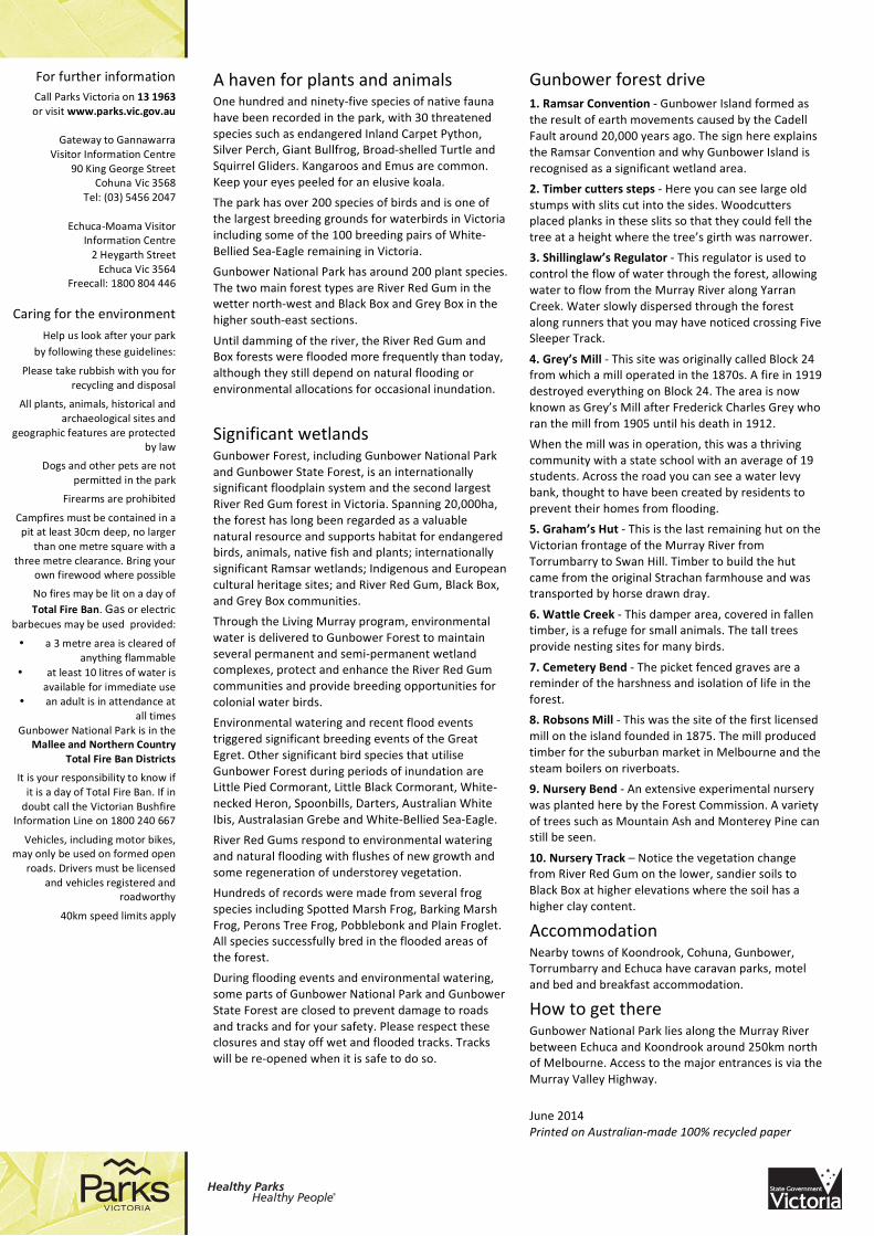
N
ACCESS MAP
PV
Torrumbarry Weir & Lock 26
Old Headworks
Masters Landing
Old Nursery Site
1
2
3
4
5
6
7
8
9
10
Disclaimer: Parks Victoria does notguarantee that this data is without flaw
of any kind and therefore disclaims allliability which may arise from you
relying on this information.
Data source acknowledgements:State Digital Mapbase. The State of Victoria andDepartment of Sustainability and Environment.
Cartography by Parks Victoria April 2014For mobile App search for Avenza PDF Maps
www.parks.vic.gov.au
21Kilometres
0 4
N
Highway
Main road
Sealed road
Unsealed road
Gunbower National Park
Murray River Reserve (pets permitted)
State Forest
Waterbody
Gunbower Forest Drive
Gunbower Heritage RiverTrail Main RouteGunbower Heritage RiverTrail Dry Weather OnlyGunbower Heritage RiverTrail Alternate Route
River Red Gum Drive(on Access Map)
4WD track
Management VehiclesOnly (MVO)
Fire district boundary
Boat ramp
Parks Victoria office
Gunbower Heritage RiverTrail points of interest
PV
1 Forest Drivestop number
Historical hutPark information
Picnic table
Car parking
Toilets
Camping area
Fire place
Visitor Information
Gunbower National Park
New
South
Wales
Victoria
COH
UN
A
KO
ON
DRO
OK
RD
WEYM
OUTHS RDDICKSONS RD
HUDSONS
TK
CENTRE
BKBARTON
TK
LOG HAULER TK
RIFL
EBU
TTS
TK FIV
ESL
EEPE
R
TK
THOMPSON
TK
WEE
WEE
RUP
TK
WEE
WEE
RUP
TK
GA
RNER
BK
CORDUROYTK
CHETTLE
TK
SWAMP
SMIT
H
TK
CENTRE
BK
NURSERY
TK
FENCE
TKEAST
ON
SR
D
86
BK86
TK
84TK
NU
RSER
YTK
BART
ON
TK
ROBE
RTSO
N
BK
ROBE
RTSO
N
TK
RIVER
TK
RIVERPETER
CREEK TK
TK
WATT
LETK
RIVER
TK
BRAYS
SPENCESBRIDGERD
RD
CA
RW
AR
DIN
ESR
D
MURRAY VALLEYHWY
MCMILLANS
MC
MIL
LAN
S
RD
MURRAY
VALLEY
PIPE
RS
RD
RA
ND
ALL
SR
DHORNSBYS RD
BOWLANDS RD
KOWSWAMP RD
GR
EEN
S
RD
RD
HW
Y
MU
RRAY
VALLEY
HWY
LEITCHVILLE
KERANG
HILDEBRAND
RD
RD
LEIT
CH
VIL
LE
PYRAMID
RD
PYRA
MID
CO
HU
NA
RD
LEITCH
VILLE
COH
UN
AR
D
COHUNA
ISLAND
RD
DALTONS
RD
BATEMANSBK
DEA
DH
OR
SE TK
STANTONBK
FREES RD
TICKELLS
TK
DEEP CREEK TK
RED
RISE
TK
SCOTTY TK
HEADWORKS RD
MCPHAIL RD
RD
NORMANRD
BAGGOT
CREEKTK
EMU
HOLE
TK
MCGILL
IVRAY
TK
BRERETONRD
MCDONALDS RD
THOMPSONS WEIR
R PEACES RD
RD
FINDLAYS RD
OBRIENS RD
OREILLYS
RD
MUNZEL RD
BA
WD
ENTK
RIVER TK
RIVER
TK
MA
TTH
EWS
RD
GA
MB
LE
TOR
RU
MB
AR
RY
WEIR
RD
DYE RD
TurnerBend
HorseshoeBend
NorrisBend
JonesBend
WilliamsBend
GonaBend
BaldwinBend
Broken RiverBend
WorthyBend
McKay MillBend
DalleyBend
LongBend
BellBend
MopokeBend
Kate MaloneBend
ScottyBend
BonnemanBend
HalfwayBend
SandbarBend
Broken RiverBend
82Bend
GravelBend
SocialBend 86
Bend
84Bend
NurseryBend No.1
NurseryBend No.2
NurseryBend No.3
CemeteryBend
McClureBend
Murray
River
Murray
River
KowSwamp
KowSwamp
G U N B O W E RS T A T E F O R E S T
G U N B O W E RS T A T E F O R E S T
To Echuca
ToPyramid Hill
G U N B O W E RS T A T E F O R E S T
G U N B O W E RS T A T E F O R E S T
To Koondrook20km
To Kerang30km
To Kerang30km
To Pyramid Hill12km To Echuca
33km
C O H U N A
G U N B O W E R
L E I T C H V I L L E
MalleeFire Ban District
Northern CountryFire Ban District
New
South
Wales
CO
HU
NA
KOO
ND
ROO
K
RD
IRON
PUNT
TK
NURSERY
TK
STANTON
BK
BRERETONRD
MURRAY
VALLEY
HWY
LEITCHVILLE
KERANG
RD
DEADHORSE
TK
RD
TOR
RU
MB
AR
RY
W
EIR
RIFL
EBU
TTS
TKFI
VE
SLEE
PER
TK THOMPSONSTK
GANNAWARRA
WEE WEE RUP
G U N B O W E RS T A T E F O R E S T
M U R R A YR I V E R
R E S E R V E
M U R R A YR I V E R
R E S E R V E
G U N B O W E RN A T I O N A L P A R K
To Kerang30km
To Echuca40km
C O H U N A
K O O N D R O O K
G U N B O W E R
Murray
River
Murray
River
42Kilometres
0 8
N
ACCESS MAP
PV
Torrumbarry Weir & Lock 26
Old Headworks
Masters Landing
Old Nursery Site
1
2
3
4
5
6
7
8
9
10
Disclaimer: Parks Victoria does notguarantee that this data is without flaw
of any kind and therefore disclaims allliability which may arise from you
relying on this information.
Data source acknowledgements:State Digital Mapbase. The State of Victoria andDepartment of Sustainability and Environment.
Cartography by Parks Victoria April 2014For mobile App search for Avenza PDF Maps
www.parks.vic.gov.au
21Kilometres
0 4
N
Highway
Main road
Sealed road
Unsealed road
Gunbower National Park
Murray River Reserve (pets permitted)
State Forest
Waterbody
Gunbower Forest Drive
Gunbower Heritage RiverTrail Main RouteGunbower Heritage RiverTrail Dry Weather OnlyGunbower Heritage RiverTrail Alternate Route
River Red Gum Drive(on Access Map)
4WD track
Management VehiclesOnly (MVO)
Fire district boundary
Boat ramp
Parks Victoria office
Gunbower Heritage RiverTrail points of interest
PV
1 Forest Drivestop number
Historical hutPark information
Picnic table
Car parking
Toilets
Camping area
Fire place
Visitor Information
Gunbower National Park
For more information call Parks Victoria on 13 1963
or visit www.parks.vic.gov.au
Healthy Parks Healthy People
Visiting a park can improve your health, mind, body and
soul. So, with over four million hectares of parkland available to Victorians, why not escape
to a park today!
pa
rkn
ote
sHealthy Parks Healthy People
Visiting a park can improve your health, mind, body and
soul. So, with over four million hectares of parkland available to Victorians, why not escape
to a park today!
For further information Call Parks Victoria on 13 1963 or visit www.parks.vic.gov.au
Gateway to Gannawarra
Visitor Information Centre 90 King George Street
Cohuna Vic 3568 Tel: (03) 5456 2047
Echuca-‐Moama Visitor
Information Centre 2 Heygarth Street Echuca Vic 3564
Freecall: 1800 804 446
Caring for the environment
Help us look after your park by following these guidelines:
Please take rubbish with you for recycling and disposal
All plants, animals, historical and archaeological sites and
geographic features are protected by law
Dogs and other pets are not permitted in the park
Firearms are prohibited
Campfires must be contained in a pit at least 30cm deep, no larger
than one metre square with a three metre clearance. Bring your
own firewood where possible
No fires may be lit on a day of Total Fire Ban. Gas or electric
barbecues may be used provided:
• a 3 metre area is cleared of anything flammable
• at least 10 litres of water is available for immediate use
• an adult is in attendance at all times
Gunbower National Park is in the Mallee and Northern Country
Total Fire Ban Districts
It is your responsibility to know if it is a day of Total Fire Ban. If in doubt call the Victorian Bushfire
Information Line on 1800 240 667
Vehicles, including motor bikes, may only be used on formed open
roads. Drivers must be licensed and vehicles registered and
roadworthy
40km speed limits apply
A haven for plants and animals One hundred and ninety-‐five species of native fauna have been recorded in the park, with 30 threatened species such as endangered Inland Carpet Python, Silver Perch, Giant Bullfrog, Broad-‐shelled Turtle and Squirrel Gliders. Kangaroos and Emus are common. Keep your eyes peeled for an elusive koala.
The park has over 200 species of birds and is one of the largest breeding grounds for waterbirds in Victoria including some of the 100 breeding pairs of White-‐Bellied Sea-‐Eagle remaining in Victoria.
Gunbower National Park has around 200 plant species. The two main forest types are River Red Gum in the wetter north-‐west and Black Box and Grey Box in the higher south-‐east sections.
Until damming of the river, the River Red Gum and Box forests were flooded more frequently than today, although they still depend on natural flooding or environmental allocations for occasional inundation.
Significant wetlands Gunbower Forest, including Gunbower National Park and Gunbower State Forest, is an internationally significant floodplain system and the second largest River Red Gum forest in Victoria. Spanning 20,000ha, the forest has long been regarded as a valuable natural resource and supports habitat for endangered birds, animals, native fish and plants; internationally significant Ramsar wetlands; Indigenous and European cultural heritage sites; and River Red Gum, Black Box, and Grey Box communities.
Through the Living Murray program, environmental water is delivered to Gunbower Forest to maintain several permanent and semi-‐permanent wetland complexes, protect and enhance the River Red Gum communities and provide breeding opportunities for colonial water birds.
Environmental watering and recent flood events triggered significant breeding events of the Great Egret. Other significant bird species that utilise Gunbower Forest during periods of inundation are Little Pied Cormorant, Little Black Cormorant, White-‐necked Heron, Spoonbills, Darters, Australian White Ibis, Australasian Grebe and White-‐Bellied Sea-‐Eagle.
River Red Gums respond to environmental watering and natural flooding with flushes of new growth and some regeneration of understorey vegetation.
Hundreds of records were made from several frog species including Spotted Marsh Frog, Barking Marsh Frog, Perons Tree Frog, Pobblebonk and Plain Froglet. All species successfully bred in the flooded areas of the forest.
During flooding events and environmental watering, some parts of Gunbower National Park and Gunbower State Forest are closed to prevent damage to roads and tracks and for your safety. Please respect these closures and stay off wet and flooded tracks. Tracks will be re-‐opened when it is safe to do so.
Gunbower forest drive 1. Ramsar Convention -‐ Gunbower Island formed as the result of earth movements caused by the Cadell Fault around 20,000 years ago. The sign here explains the Ramsar Convention and why Gunbower Island is recognised as a significant wetland area.
2. Timber cutters steps -‐ Here you can see large old stumps with slits cut into the sides. Woodcutters placed planks in these slits so that they could fell the tree at a height where the tree’s girth was narrower.
3. Shillinglaw’s Regulator -‐ This regulator is used to control the flow of water through the forest, allowing water to flow from the Murray River along Yarran Creek. Water slowly dispersed through the forest along runners that you may have noticed crossing Five Sleeper Track.
4. Grey’s Mill -‐ This site was originally called Block 24 from which a mill operated in the 1870s. A fire in 1919 destroyed everything on Block 24. The area is now known as Grey’s Mill after Frederick Charles Grey who ran the mill from 1905 until his death in 1912.
When the mill was in operation, this was a thriving community with a state school with an average of 19 students. Across the road you can see a water levy bank, thought to have been created by residents to prevent their homes from flooding.
5. Graham’s Hut -‐ This is the last remaining hut on the Victorian frontage of the Murray River from Torrumbarry to Swan Hill. Timber to build the hut came from the original Strachan farmhouse and was transported by horse drawn dray.
6. Wattle Creek -‐ This damper area, covered in fallen timber, is a refuge for small animals. The tall trees provide nesting sites for many birds.
7. Cemetery Bend -‐ The picket fenced graves are a reminder of the harshness and isolation of life in the forest.
8. Robsons Mill -‐ This was the site of the first licensed mill on the island founded in 1875. The mill produced timber for the suburban market in Melbourne and the steam boilers on riverboats.
9. Nursery Bend -‐ An extensive experimental nursery was planted here by the Forest Commission. A variety of trees such as Mountain Ash and Monterey Pine can still be seen.
10. Nursery Track – Notice the vegetation change from River Red Gum on the lower, sandier soils to Black Box at higher elevations where the soil has a higher clay content.
Accommodation Nearby towns of Koondrook, Cohuna, Gunbower, Torrumbarry and Echuca have caravan parks, motel and bed and breakfast accommodation.
How to get there Gunbower National Park lies along the Murray River between Echuca and Koondrook around 250km north of Melbourne. Access to the major entrances is via the Murray Valley Highway.
June 2014 Printed on Australian-‐made 100% recycled paper