Embed Size (px)
Citation preview
Page 1 of 11
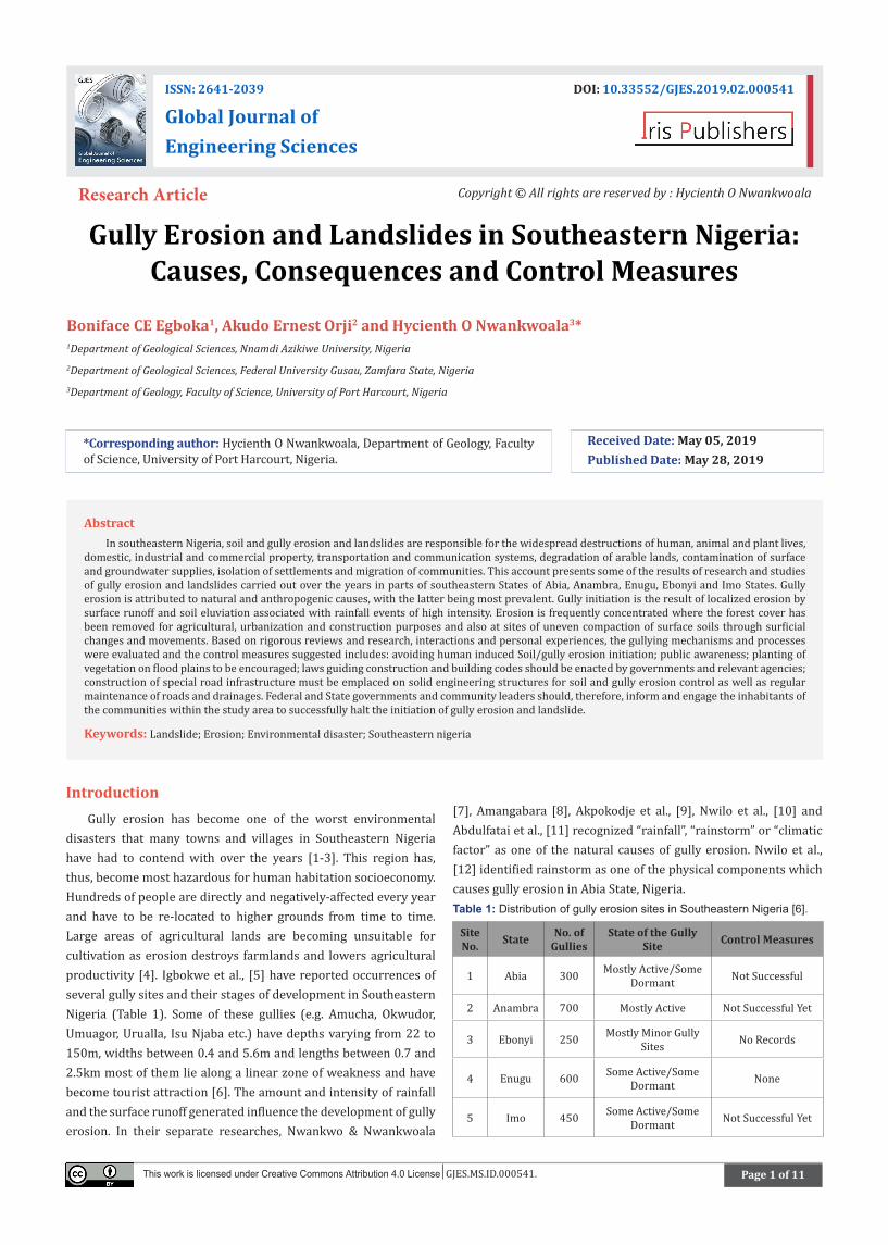
Gully Erosion and Landslides in Southeastern Nigeria: Causes, Consequences and Control Measures
Boniface CE Egboka1, Akudo Ernest Orji2 and Hycienth O Nwankwoala3*1Department of Geological Sciences, Nnamdi Azikiwe University, Nigeria2Department of Geological Sciences, Federal University Gusau, Zamfara State, Nigeria3Department of Geology, Faculty of Science, University of Port Harcourt, Nigeria
IntroductionGully erosion has become one of the worst environmental
disasters that many towns and villages in Southeastern Nigeria have had to contend with over the years [1-3]. This region has, thus, become most hazardous for human habitation socioeconomy. Hundreds of people are directly and negatively-affected every year and have to be re-located to higher grounds from time to time. Large areas of agricultural lands are becoming unsuitable for cultivation as erosion destroys farmlands and lowers agricultural productivity [4]. Igbokwe et al., [5] have reported occurrences of several gully sites and their stages of development in Southeastern Nigeria (Table 1). Some of these gullies (e.g. Amucha, Okwudor, Umuagor, Urualla, Isu Njaba etc.) have depths varying from 22 to 150m, widths between 0.4 and 5.6m and lengths between 0.7 and 2.5km most of them lie along a linear zone of weakness and have become tourist attraction [6]. The amount and intensity of rainfall and the surface runoff generated influence the development of gully erosion. In their separate researches, Nwankwo & Nwankwoala
[7], Amangabara [8], Akpokodje et al., [9], Nwilo et al., [10] and Abdulfatai et al., [11] recognized “rainfall”, “rainstorm” or “climatic factor” as one of the natural causes of gully erosion. Nwilo et al., [12] identified rainstorm as one of the physical components which causes gully erosion in Abia State, Nigeria.Table 1: Distribution of gully erosion sites in Southeastern Nigeria [6].
Site No. State No. of
GulliesState of the Gully
Site Control Measures
1 Abia 300 Mostly Active/Some Dormant Not Successful
2 Anambra 700 Mostly Active Not Successful Yet
3 Ebonyi 250 Mostly Minor Gully Sites No Records
4 Enugu 600 Some Active/Some Dormant None
5 Imo 450 Some Active/Some Dormant Not Successful Yet
*Corresponding author: Hycienth O Nwankwoala, Department of Geology, Faculty of Science, University of Port Harcourt, Nigeria.
Received Date: May 05, 2019 Published Date: May 28, 2019
ISSN: 2641-2039 DOI: 10.33552/GJES.2019.02.000541
Global Journal of Engineering Sciences
Research Article Copyright © All rights are reserved by : Hycienth O Nwankwoala
This work is licensed under Creative Commons Attribution 4.0 License GJES.MS.ID.000541.
Abstract In southeastern Nigeria, soil and gully erosion and landslides are responsible for the widespread destructions of human, animal and plant lives,
domestic, industrial and commercial property, transportation and communication systems, degradation of arable lands, contamination of surface and groundwater supplies, isolation of settlements and migration of communities. This account presents some of the results of research and studies of gully erosion and landslides carried out over the years in parts of southeastern States of Abia, Anambra, Enugu, Ebonyi and Imo States. Gully erosion is attributed to natural and anthropogenic causes, with the latter being most prevalent. Gully initiation is the result of localized erosion by surface runoff and soil eluviation associated with rainfall events of high intensity. Erosion is frequently concentrated where the forest cover has been removed for agricultural, urbanization and construction purposes and also at sites of uneven compaction of surface soils through surficial changes and movements. Based on rigorous reviews and research, interactions and personal experiences, the gullying mechanisms and processes were evaluated and the control measures suggested includes: avoiding human induced Soil/gully erosion initiation; public awareness; planting of vegetation on flood plains to be encouraged; laws guiding construction and building codes should be enacted by governments and relevant agencies; construction of special road infrastructure must be emplaced on solid engineering structures for soil and gully erosion control as well as regular maintenance of roads and drainages. Federal and State governments and community leaders should, therefore, inform and engage the inhabitants of the communities within the study area to successfully halt the initiation of gully erosion and landslide.
Keywords: Landslide; Erosion; Environmental disaster; Southeastern nigeria
Global Journal of Engineering Sciences Volume 2-Issue 4
Citation: Boniface CE Egboka, Akudo Ernest Orji, Hycienth O Nwankwoala. Gully Erosion and Landslides in Southeastern Nigeria: Causes, Consequences and Control Measures. Glob J Eng Sci. 2(4): 2019. GJES.MS.ID.000541. DOI: 10.33552/GJES.2019.02.000541.
Page 2 of 11
The formation of gullies is influenced by increased surface runoff which acts as cutting agent. The very great depths of these gullies and the failure of almost all control measures strongly suggest that they may result from interplay of exogenic and endogenic forces [12]. As shown in Table 1 below, not much of successful attempts have been made by governments in the control of major gullies. Some efforts have been made at Anambra and Imo States, but these efforts are not encouraging enough. The people and communities have tried some palliative control measures that seem not to remedy the disastrous situations really.
Landslides in Nigeria are more profound in the southern part of the country than in the northern part. In Southeastern Nigeria, landslide is caused mainly by gully erosion [14]. Widespread occurrences of large and deep gullies in the southeastern part of Nigeria and the annual impact of rainfall induced floods has been reported to weaken the ground around the gully sites and slopes, resulting in landslides in many locations [5,14]. In 1988 a major landslide that required the evacuation of more than 50 families, occurred in the town of Nanka in Anambra State, Nigeria. Investigation revealed that the landslides were caused by an over-consolidated, very highly plastic mudstone layer (PI=67) which probably contained quantities of montmorillonite clay [15]. Gully initiation is the result of localized erosion by surface runoff, associated with rainfall events of high intensity. Erosion is frequently concentrated where the forest cover has been removed for agricultural purposes and also at the sites of uneven compaction of surface soils by foot (human and livestock) and vehicular traffic at roads and in off-road locations. It also takes place where soils and sediments abut against artificial materials, notably at poorly designed road culverts and roadside gutters. Gullies also occur
where springs issue from permeable sands at contacts with less permeable deposits beneath the sedimentary strata. In general, the propagation of gullies is by sapping, caving-in and sliding at the gully head and sliding along the gully walls and sides, accompanied by the down-slope transportation of gully-floor debris by storm water runoff [16].
Erosivity and erodibility are the factors that contribute to soil erosion and gully formation. Erosivity is a function of rainfall, a natural phenomenon which is outside human control and manipulation. Rainfall intensities can be usually high in Southeast Nigeria. Obi and Salako [17] reported that rainfalls with intensities between the ranges of 100 to 125mmh-1 are likely to occur more than five times a year. Storms with 25mm/h intensity have been reported by Hudson (1981) to be erosive. Erodibility, on the other hand, is dependent on soil properties, topography, and land management. Appropriate land management is very important in an area like Southeast Nigeria where the geotectonic, geologic, and geohydrologic characteristics of the region make many areas within it susceptible to gully erosion. For example, cuestas, fractures and joints are common features in the gully-erosion-prone areas of Southeastern Nigeria and have been identified as significant factors in the formation of gully erosion and landslides [18,19].
Several studies have been conducted on the causes of gully erosion in Southeastern Nigeria and ways to control them. Studies so far conducted on the causes and impacts of the gully erosion in the area have considered interviews, modeling, geological, hydrological and geotechnical investigation techniques [20-24]. This paper, therefore, appraises gully erosion and landslides, its causes, consequences and control measures in Southeastern Nigeria.
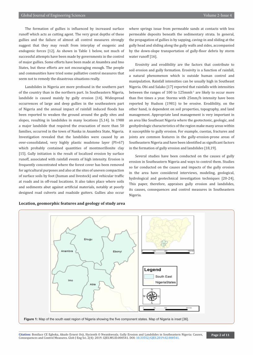
Location, geomorphic features and geology of study area
Figure 1: Map of the south east region of Nigeria showing the five component states. Map of Nigeria is inset [36].
Citation: Boniface CE Egboka, Akudo Ernest Orji, Hycienth O Nwankwoala. Gully Erosion and Landslides in Southeastern Nigeria: Causes, Consequences and Control Measures. Glob J Eng Sci. 2(4): 2019. GJES.MS.ID.000541. DOI: 10.33552/GJES.2019.02.000541.
Global Journal of Engineering Sciences Volume 2-Issue 4
Page 3 of 11
The study area is located within latitudes 4° 47’ 35‟N and 7° 7’ 44‟N, and longitudes 7° 54‟ 26‟E and 8° 27‟ 10‟E (Figure 1) in the tropical rain forest zone of Nigeria. The study area has mean maximum temperature of 27 °C and total annual rainfall exceeding 2500mm [22]. There is usually early rainfall in January/February with full commencement of rainy season in March and stopping in November of each year. The dry season lasts between four to five months. The highest rainfall is recorded from July to October with little break in rainfall in August popularly described as “August break”. The area comprises the geographical location of the following States: Abia, Anambra, Ebonyi, Enugu and Imo. The relative location is bounded in the north west by Kogi and Benue States, in the northeast by Cross River State, in the South by Akwa Ibom and Rivers States and finally in the West by Delta State, as shown on Figure 1 below. The area is well drained. The notable lakes, rivers and streams that are found draining the area in this zone include Rivers Niger, Imo, Nike Lake, Anambra, Idemili, Njaba, Oguta Lake, Nkisi, Ezu, Oji etc.
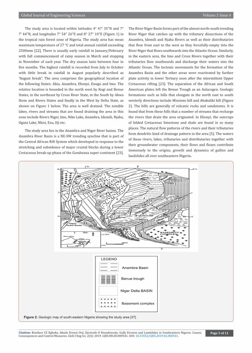
The study area lies in the Anambra and Niger River basins. The Anambra River Basin is a NE-SW trending syncline that is part of the Central African Rift System which developed in response to the stretching and subsidence of major crustal blocks during a lower Cretaceous break-up phase of the Gondwana super-continent [23].
The River Niger Basin forms part of the almost north-south trending River Niger that catches up with the tributary dissections of the Anambra, Idemili and Njaba Rivers as well as their distributaries that flow from east to the west as they forcefully-empty into the River Niger that flows southwards into the Atlantic Ocean. Similarly, in the eastern area, the Imo and Cross Rivers together with their tributaries flow southwards and discharge their waters into the Atlantic Ocean. The tectonic movements for the formation of the Anambra Basin and the other areas were reactivated by further plate activity in lower Tertiary soon after the intermittent Upper Cretaceous rifting [23]. The separation of the African and South American plates left the Benue Trough as an Aulacogen. Geologic formations such as hills that elongate in the north east to south westerly directions include Missions hill and Abakaliki hill (Figure 2). The hills are generally of volcanic rocks and sandstones. It is found that from these hills that a number of streams that recharge the rivers that drain the area originated. In Ebonyi, the outcrops of folded Cretaceous limestone and shale are found in so many places. The natural flow patterns of the rivers and their tributaries form dendritic kind of drainage pattern in the area [5]. The waters of these rivers, lakes, tributaries and distributaries together with their groundwater components, their flows and fluxes contribute immensely to the origins, growth and dynamics of gullies and landslides all over southeastern Nigeria.
Figure 2: Geologic map of south-eastern Nigeria showing the study area [37].
Global Journal of Engineering Sciences Volume 2-Issue 4
Citation: Boniface CE Egboka, Akudo Ernest Orji, Hycienth O Nwankwoala. Gully Erosion and Landslides in Southeastern Nigeria: Causes, Consequences and Control Measures. Glob J Eng Sci. 2(4): 2019. GJES.MS.ID.000541. DOI: 10.33552/GJES.2019.02.000541.
Page 4 of 11
The Geology of the area is a major factor in gully erosion causation and massive landslides that occur in several communities. The sandy members of the Ajalli Sandstone, Ameki Formation and Nanka Sands are very prevalent to denudation where they become exposed as sandy outcrops. Sometimes these sandy Formations have overlying and underlying shaley members that may bind the sandy units together. These Geologic Formations contain saturated groundwater members or aquifers whose pore water pressures enhance groundwater flows and movement of sedimentary materials. Sedimentary units of these Formations sometimes form escarpments or cuestas that may be folded and faulted with fractures of joints and faults all of with planes of weaknesses which facilitate the incidences of gully erosion and landslides. Blocks of sedimentary units of rocky sands and shales may break out and slide downslope into the gully valleys.
Demography, urbanization and socioeconomic effects
In 2006, the population of the southeastern States of Abia, Anambra, Ebonyi, Enugu and Imo were 2,833,999, 4,182,032, 2,173,503, 3,257,298 and 3,934,899 respectively (Table 2). Although Enugu State has the highest landmass (12,440km2), Anambra State with a landmass of 4,844km2 has the highest population density (863people/km2). As more rural areas in the Southeastern Nigeria acquire urban status, there is generally improved standard of living, job opportunities and increased literacy level, exposure to people from different parts of the world and improved medical facilities which orchestrate rural-urban migration. However, urbanization results in high cost of living, environmental pollution, deforestation, high population density, high crime rate, impersonality, high rate of accidents and a host of other socioeconomic problems. The increase in demographic growth in population and urbanization put a lot of stress on the system that may result in some of the environmental disasters of floods, soil and gully erosion, landslides, environmental pollution and contamination all compounded by the incidence of global climate change.Table 2: Demographic characteristics of the Southeastern States.
States Population Landmass (Km2)
Population Density (People/Km2)
Abia 2,834.00 5,420.00 441
Anambra 4,182,032 4,844.00 863
Ebonyi 2,173,501 5,530.00 393
Enugu 3,257,298 12,440.00 262
Imo 3,934,899 5,430.00 725
(Source: National Population Commission, 2006).
Causes of Soil/Gully Erosion and Landslides in The Southeast
The causes of soil and gully erosion and landslides can be classified into natural and anthropogenic causes as briefly discussed below.
Natural causes
Soil and gully erosion and landslides problems arise mainly from natural causes, but their extent and severity are increasingly being attributed to man’s negative environmental impacts due to
ignorance and unintentional action [24]. Natural causes of gully erosion and landslides are high rainfall intensity, low vegetation cover, high altitude, strength of soils and surficial sediments and groundwater/soil interactions. The average annual rainfall in the southern part of Nigeria is over 2000mm. The yearly heavy rainfall has very adverse impacts altering existing landscape and landform. Such landforms create deep gullies that cut into the soil deep down into the subsurface. The gullies which develop from soil outwash, rills and shallow channels, spread and grow until the soil is removed from the sloping ground and mature into deep gullies. Gullies when formed expand rapidly coupled with exceptional storm or torrential rain and floods that rush down into the streams and rivers by headward erosion, gulping up arable lands, economic trees, homes, lives and property and sacking of families and homes [25] and valuable properties that are worth millions of Naira. Although rainfall intensity ranks highest among the natural causes of gully erosion and landslide, man’s activities (deforestation, fossil fuel burning and indiscriminate construction) have indirectly influenced rainfall intensity.
Man-made or anthropogenic causes
Studies have revealed that the major forces causing erosion is the expanding of socio-political power and the necessity of the poor to fulfill their requirements of food, fuel wood and fodder [26]. The studies concluded that unless vast masses of poor people are integrated into the national mainstream through the implementation of equitable and redistributive development policies, it is impossible to control the accelerating rate of flood disasters, soil and gully erosion. In the tropics and semi-arid regions, the ever-abiding presences of gullies are seen to be prevalent. This is, however, associated with traditional agricultural practice seen in that area [27]. Beside the evacuation of farmlands through the excessive removal of the topsoil, bridges, roads, telecommunication, railway lines and electric poles are continuously washed away into rivers including the silting up of lakes, springs and streams. Within the last decade, urbanization and expansion of cities and facilities to improve standard of living and provide for the ever-growing population has exacerbated man’s influence on the severity of gully erosion and landslide occurrences. Development of urban, commercial and industrial centers and population growth has many socioeconomic complexities that negatively-impact upon the sensitive environment. More lands are cleared, thereby, resulting in deforestation, for agricultural practices to grow more food to feed the increasing population. The Nigeria-Biafra war that lasted for three years from 1967 to January 1970 in the then Eastern Nigeria caused a lot of devastation of the environment of the war-ravaged area such as excessive bombardment, digging of obstacles, heavy vehicular movements, concentration of refugee-population etc. All these put enormous negative stresses on the land, the highly commercial and industrial centers of Onitsha, Nnewi, Aba, Umuahia etc. stressed the study area inexorably and was destroying the land. Heavy oil tanker-vehicle transport from the gas and oil fields of the south Niger Delta areas and huge trailers from the Lagos-Southwest as well as the northern Nigeria areas all stress the gully erosion-prone roads as there are no international airports or
Citation: Boniface CE Egboka, Akudo Ernest Orji, Hycienth O Nwankwoala. Gully Erosion and Landslides in Southeastern Nigeria: Causes, Consequences and Control Measures. Glob J Eng Sci. 2(4): 2019. GJES.MS.ID.000541. DOI: 10.33552/GJES.2019.02.000541.
Global Journal of Engineering Sciences Volume 2-Issue 4
Page 5 of 11
seaports for movements of heavy cargo and merchandise. These heavy and continuous vehicular movements that crisscross the poorly constructed eastern roads regularly-destroy them and cause emergence of road gullies all over the east.
Environmental impacts and implications
The socioeconomic-cum-environmental impact of gully erosion and landslides are quite enormous. These impacts include loss of human, animal and plant lives and farmlands, destruction of houses and people’s property, damage of roads and other infrastructure and displacement of citizens, forcing to become refugees in their homelands. They impact are further discussed below.
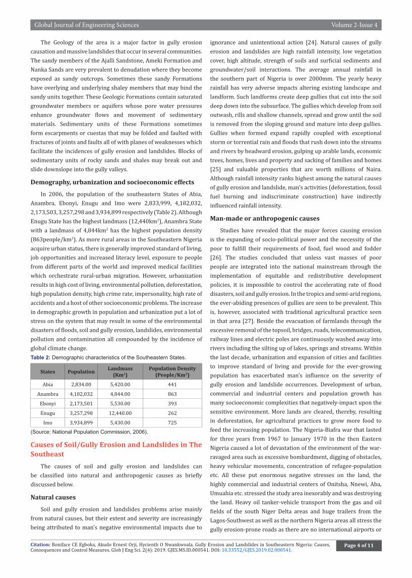
• Displacement of Large Population of People and Refugees: The entire Communities in Amaokwe (see some erosion sites in Figures 3&4), Abia State University, Uturu, Ogudasa and Oruruala were completely displaced due to the expansion of gully sites. The Amuzukwu community in Umuahia North L.G.A of Abia State suffered the same fate and is now hapless refugees. Figure 3: Gully erosion site in Amaokwe.
Figure 4: Eroded sites in Amaokwe Community, Abia State.
Figure 5: A Gully site in Umuchiana, Aguata, Anambra State, Abia State.
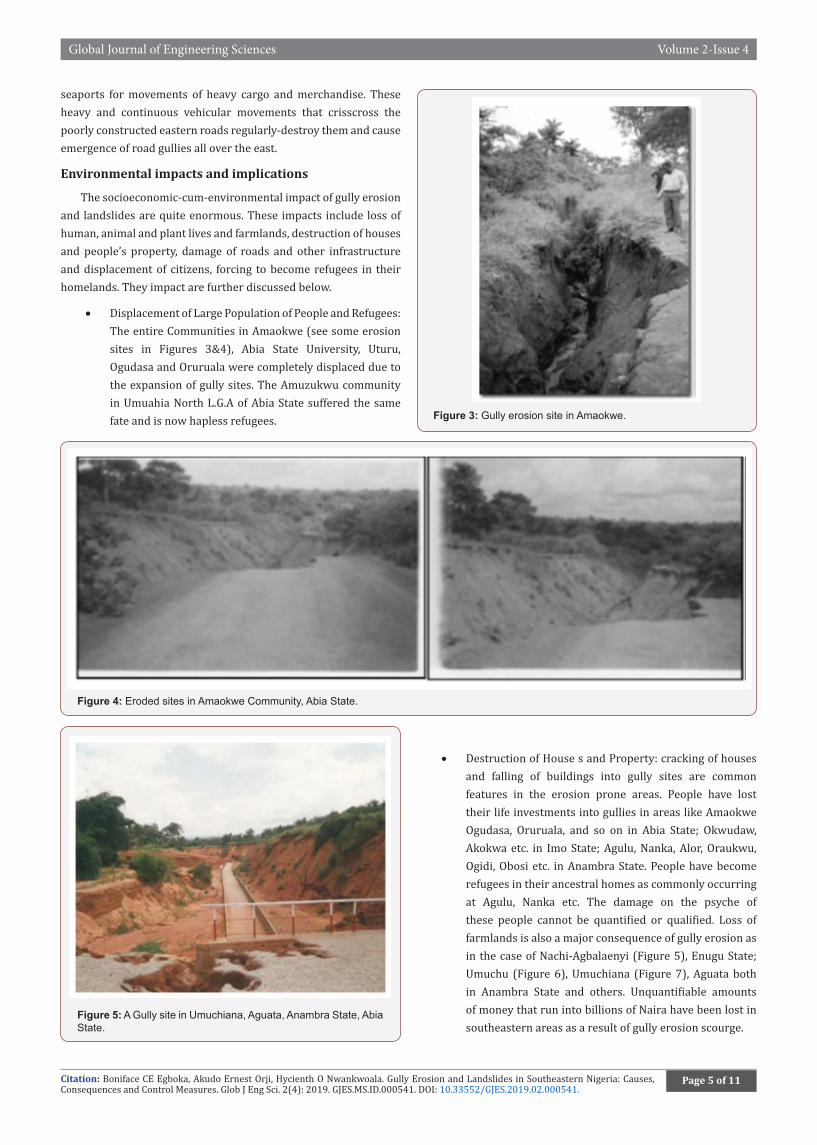
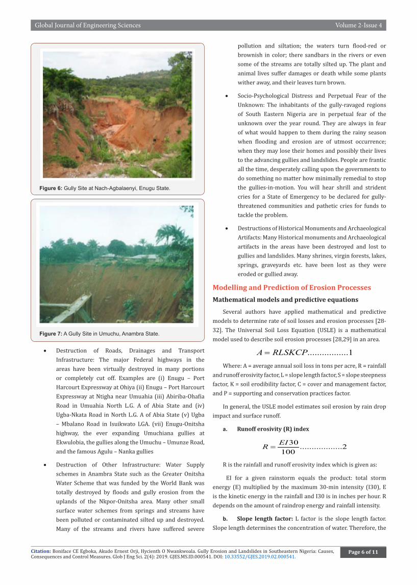
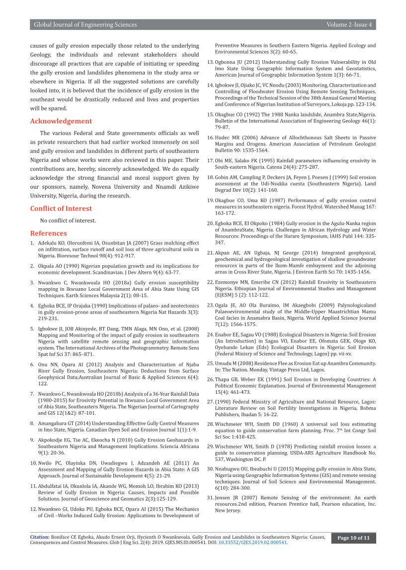
• Destruction of House s and Property: cracking of houses and falling of buildings into gully sites are common features in the erosion prone areas. People have lost their life investments into gullies in areas like Amaokwe Ogudasa, Oruruala, and so on in Abia State; Okwudaw, Akokwa etc. in Imo State; Agulu, Nanka, Alor, Oraukwu, Ogidi, Obosi etc. in Anambra State. People have become refugees in their ancestral homes as commonly occurring at Agulu, Nanka etc. The damage on the psyche of these people cannot be quantified or qualified. Loss of farmlands is also a major consequence of gully erosion as in the case of Nachi-Agbalaenyi (Figure 5), Enugu State; Umuchu (Figure 6), Umuchiana (Figure 7), Aguata both in Anambra State and others. Unquantifiable amounts of money that run into billions of Naira have been lost in southeastern areas as a result of gully erosion scourge.
Global Journal of Engineering Sciences Volume 2-Issue 4
Citation: Boniface CE Egboka, Akudo Ernest Orji, Hycienth O Nwankwoala. Gully Erosion and Landslides in Southeastern Nigeria: Causes, Consequences and Control Measures. Glob J Eng Sci. 2(4): 2019. GJES.MS.ID.000541. DOI: 10.33552/GJES.2019.02.000541.
Page 6 of 11
Figure 6: Gully Site at Nach-Agbalaenyi, Enugu State.
Figure 7: A Gully Site in Umuchu, Anambra State.
• Destruction of Roads, Drainages and Transport Infrastructure: The major Federal highways in the areas have been virtually destroyed in many portions or completely cut off. Examples are (i) Enugu – Port Harcourt Expressway at Ohiya (ii) Enugu – Port Harcourt Expressway at Ntigha near Umuahia (iii) Abiriba-Ohafia Road in Umuahia North L.G. A of Abia State and (iv) Ugba-Nkata Road in North L.G. A of Abia State (v) Ugba – Mbalano Road in Isuikwato LGA. (vii) Enugu-Onitsha highway, the ever expanding Umuchiana gullies at Ekwulobia, the gullies along the Umuchu – Umunze Road, and the famous Agulu – Nanka gullies
• Destruction of Other Infrastructure: Water Supply schemes in Anambra State such as the Greater Onitsha Water Scheme that was funded by the World Bank was totally destroyed by floods and gully erosion from the uplands of the Nkpor-Onitsha area. Many other small surface water schemes from springs and streams have been polluted or contaminated silted up and destroyed. Many of the streams and rivers have suffered severe
pollution and siltation; the waters turn flood-red or brownish in color; there sandbars in the rivers or even some of the streams are totally silted up. The plant and animal lives suffer damages or death while some plants wither away, and their leaves turn brown.
• Socio-Psychological Distress and Perpetual Fear of the Unknown: The inhabitants of the gully-ravaged regions of South Eastern Nigeria are in perpetual fear of the unknown over the year round. They are always in fear of what would happen to them during the rainy season when flooding and erosion are of utmost occurrence; when they may lose their homes and possibly their lives to the advancing gullies and landslides. People are frantic all the time, desperately calling upon the governments to do something no matter how minimally remedial to stop the gullies-in-motion. You will hear shrill and strident cries for a State of Emergency to be declared for gully-threatened communities and pathetic cries for funds to tackle the problem.
• Destructions of Historical Monuments and Archaeological Artifacts: Many Historical monuments and Archaeological artifacts in the areas have been destroyed and lost to gullies and landslides. Many shrines, virgin forests, lakes, springs, graveyards etc. have been lost as they were eroded or gullied away.
Modelling and Prediction of Erosion ProcessesMathematical models and predictive equations
Several authors have applied mathematical and predictive models to determine rate of soil losses and erosion processes [28-32]. The Universal Soil Loss Equation (USLE) is a mathematical model used to describe soil erosion processes [28,29] in an area.
.................1A RLSKCP=
Where: A = average annual soil loss in tons per acre, R = rainfall and runoff erosivity factor, L = slope length factor, S = slope steepness factor, K = soil erodibility factor, C = cover and management factor, and P = supporting and conservation practices factor.
In general, the USLE model estimates soil erosion by rain drop impact and surface runoff.
a. Runoff erosivity (R) index
30 ..................2100EIR =
R is the rainfall and runoff erosivity index which is given as:
EI for a given rainstorm equals the product: total storm energy (E) multiplied by the maximum 30-min intensity (I30), E is the kinetic energy in the rainfall and I30 is in inches per hour. R depends on the amount of raindrop energy and rainfall intensity.
b. Slope length factor: L factor is the slope length factor. Slope length determines the concentration of water. Therefore, the

Citation: Boniface CE Egboka, Akudo Ernest Orji, Hycienth O Nwankwoala. Gully Erosion and Landslides in Southeastern Nigeria: Causes, Consequences and Control Measures. Glob J Eng Sci. 2(4): 2019. GJES.MS.ID.000541. DOI: 10.33552/GJES.2019.02.000541.
Global Journal of Engineering Sciences Volume 2-Issue 4
Page 7 of 11
greater the length of slope of a field the greater the concentration of water and run off. A Digital elevation Model data (DEM) if used together with ArcGIS tools, flow direction and flow accumulation of the study area can be computed [30]. The equation used for computing slope length is:
( )0.4.......322.13
CellsizeDEM FlowDirection FlowAccumulation> > ∗
c. Slope steepness factor: S factor is the slope steepness factor. This is the steepness of the area of study. As a rule, the greater the slope steepness the more erosion that can be expected. DEM data is also used to compute the S factor in ArcGIS. The equation used to compute the slope steepness is:
( )1.3Sin3.14 ......4180 0.0869SlopeDEM Slope> > ∗ >
d. Soil erodibility factor: K factor is the soil erodibility factor. This is an estimate of the ability of soils to resist erosion, based on the physical characteristics of each soil. It depends on soil structure, texture and composition. In this project, K factor is based on values established in literature. A high K factor indicates a lower water infiltration rate thus more prone to erosion. K factor was derived from tables provided by Roose [33].
e. Cover and management factor: Cover and management factor (C factor) indicate the influence of cropping systems and management variables on soil erosion. This factor depends on four sub factors: Prior land use, canopy cover, soil surface cover and surface roughness.
f. Normalized difference vegetation index (NDVI): The normalized difference vegetation index (NDVI) is a simple numerical indicator that can be used to analyze remote sensing measurements, to ascertain whether the target being observed contains live green vegetation or not [31,32]. The NDVI is calculated as follows.
..........5nir redred
nir
P pNDVI PP−= +
g. Correlation model: The Pearson Product Moment Correlation model can be used to determine relationship between soil erosion loss and NDVI value. The correlation model is expressed as follows [30]:
..........6Risk H V= ∗
H = Hazard, and V = Vulnerability
The soil erosion risk was determined from Equation (6)
h. Multivariate analytic model: Logistic regression is a multivariate analytic model useful for predicting the presence or absence of a characteristic or outcome based on values of a set of predictor variables [34].
Quantitatively, the relationship between the occurrence and its dependency on several variables can be expressed as [13]:
( )1 ...............7
1 zPe−=
+
Where p is the probability of an event occurring. The value p is the estimated probability of gully occurrence. The probability varies
from 0 to 1 on a sigmoidal (S) curve and z is the linear combination. It follows that logistic regression involves fitting an equation of the following form to the data:
0 1 1 2 2 ..... ...........8n nZ b b X b X b X= + + +
Where: b0 is the intercept of the model, the b1 (i = 0, 1, 2… n) are the slope coefficients of the logistic regression model, and the x1 (i= 0, 1, 2… n) are the independent variables. The linear model formed is then a logistic regression of presence or absence of gullies [13] on the independent variables.
Uses for predicting rates of sediment removal and soil loss
Mathematical and predictive models are applied for the following in order to:
• Estimate amount of soil loss to erosion in tons per acre per year;
• Determine the impact of vegetal cover in soil erosion process using NDVI;
• Develop erosion vulnerability index for an area;
• Develop a risk index and determine possible affected places; and
• Determine the role of causative factors (slope, distance from drainage, land use and vegetation) on the frequency of gully occurrences.
Results and DiscussionCase example of researches so far on erosion studies in the southeast
Figure 8: Plot of Runoff Shear Stress Flow Depth for Various Slope Angles of Ground Surface [7].
Findings from previous research [12] revealed that soil and gully erosion would be expected to occur when the shear stress of runoff exceeds the soil shear strength. Table 3 and Figure 8 show that the shear strength of topsoil’s is higher than the shear stress of runoff for normal ground surface slope angles of less than 50 and

Global Journal of Engineering Sciences Volume 2-Issue 4
Citation: Boniface CE Egboka, Akudo Ernest Orji, Hycienth O Nwankwoala. Gully Erosion and Landslides in Southeastern Nigeria: Causes, Consequences and Control Measures. Glob J Eng Sci. 2(4): 2019. GJES.MS.ID.000541. DOI: 10.33552/GJES.2019.02.000541.
Page 8 of 11
few depths that occur naturally (much less than 10cm). The red earth (RE) and, in particular, the bottom parent material (FS) have a shear strength values that are less than or marginally comparable to runoff shear stress, more so when flow is not concentrated. It is thus clear that once the topsoil is removed and/or runoff is concentrated (i.e. increase in flow depth), erosion is inevitable. One obvious way by which the top soil is removed and run off is concentrated is through recklessly-executed road construction and civil engineering works and to a very much less degree by traditional or even sophisticated farming practices, suggesting that civil works rather than farming practices are responsible for the erosion problems.
Table 3: Some Textural Properties of Soil and Surficial Sediments from Parts of South-Eastern Nigeria (TS= Topsoil, RE= Red Earth, FS= Unaltered Parent Geologic Material). (Source: Techno Nigeria Limited Report, cited in [7]).
Location No. of Samples Horizon % Fines
(Clay + Silt)Shear Strength
(KN/M2)
Okwudor 3TS 0.9-1.4 15-16.2
RE 0.9-1.6 10.1-9.8
Amucha 4
FS 0.2-0.3 3.0-3.5
TS 1.0-1.2 23.0-24.5
RE 0.6-1.0 18.5-20.2
FS 0.1-0.2 2.1-3.0
Owerri 3
TS 0.9-1.3 5.0-6.0
RE 1.2-1.5 6.0-6.5
FS 1.1-1.0 6.2-6.3
Okigwe 3
TS 4.7-5.0 26.0-25.2
RE 1.8-1.9 24.0-26.5
FS 0.1-0.2 2.0-3.1
Agulu/Nanka 6
TS 1.9-2.0 24.6-25.2
RE 0.6-0.8 18.1-19.5
FS 0.2-0.3 2.30-3.3
Enugu 1TS 70 60
FS 60.2 54
On the nature of topography, a study revealed that gully developments are more pronounced in areas with high terrain undulation [5]. In these areas, the slopes of the ground are steep and vary. This inevitably results in increase in the speed and volume of the overland flow and subsequently the rate of detachment and transportation of soil particles (Table 4).
Table 4: Soil loss in Gully areas in Southeastern Nigeria [5].
S/No. StateSoil Loss (Tons/Ha/Yr)
Min (In Low Areas) Max (In High Areas)
1 Abia 9.2 10.16
2 Anambra 9.11 10.03
3 Ebonyi 8.71 9.6
4 Enugu 9.46 10.54
5 Imo 9.23 9.93
Soil and gully erosion have had more devastating effect on farmlands and farming activities in Southeastern Nigeria. Tables 5&6 show the distribution of land use/land (LU/LC), soil loss, and normalized difference vegetation index (NDVI) for Abia State in 1986 and 2003 respectively. Change analysis was conducted on each of the LU/LC categories [30]. The results obtained showed that farmland in the study area was about 2402.05 km2 in 1986 but by 2003 this had reduced to 791.42 km2. On the other hand, while built-up area was 143.289 km2 in 1986 (covering 3%) it increased to 1791.314 km2 in 2003 (covering 33%). The wetland witnessed a loss from 84.729 km2 in 1986 to 29.725 km2 in 2003. Bare ground areas experienced a 12% (674.235 km2) increase in 2003 over the 1986 figure (514.405 km2). Secondary forest in the study area was about 2297.83 km2 in 1986 but it was reduced to 2045.45 km2 in 2003. Primary forest increased marginally from 104.076 km2 (2%) in 1986 to 105.358 km2 in 2003. A decrease in the area of water bodies was experienced from 5.318 km2 in 1986 to 4.16 km2 in 2003.
Table 5: Land use/land cover, soil loss and NDVI in Abia State in 1986.
Land Use/Land Cover Area (km2) Area (%)Soil Loss
NDVI Scale NDVIMin Max Mean
Farmland 2402.054 43.69 0 1051.32 24.14 0.14 116.16
Built-Up Area 143.289 2.6 0 456.92 29.68 0.08 107.06
Bare Ground 514.405 9.35 0 1082.58 48.93 0.07 109.6
Secondary Forest 2297.833 41.8 0 503.01 9.22 0.18 119.13
Primary Forest 104.076 1.9 0 39.38 1.1 0.23 120.64
Water Bodies 5.318 0.096 0 4.57 1.32 -0.08 88.48
Wetlands 29.725 0.54 0 152.81 4 0.21 123.78
Table 6: Land use/land cover, soil loss and NDVI in Abia State in 2003.
Land Use/Land Cover Area (km2) Area (%)Soil Loss (Ton/Acres)
NDVI Scale NDVIMin Max Mean
Farmland 791.42 14.46 0 928.72 13.64 0.16 116.9
Built-Up Area 1791.314 32.58 0 584.86 33.46 0.08 101.09
Bare Ground 674.235 12.26 0 1120.59 36.46 0.1 104.95
Secondary Forest 2045.451 37.21 0 538.9 9.59 0.19 120.44

Citation: Boniface CE Egboka, Akudo Ernest Orji, Hycienth O Nwankwoala. Gully Erosion and Landslides in Southeastern Nigeria: Causes, Consequences and Control Measures. Glob J Eng Sci. 2(4): 2019. GJES.MS.ID.000541. DOI: 10.33552/GJES.2019.02.000541.
Global Journal of Engineering Sciences Volume 2-Issue 4
Page 9 of 11
Primary Forest 105.358 1091 0 626.6 11.92 0.21 118.61
Water Bodies 4.193 0.07 0 707.93 26.87 -0.11 106.44
Wetlands 84.729 1.54 0 73.75 1.62 0.23 123.81
Suggested control measures
In view of a thorough review of causes, development and consequences of soil/gully erosion and landslides in the Southeastern Nigeria, the following control measures have been suggested to assist the public, government, researchers and affected communities. They include;
• Avoid human induced Soil/gully erosion initiation: such practices as illegal and reckless removal of topsoil, overgrazing, continuous cropping, dumping of wastes and blocking of drains etc. must be avoided.
• Public awareness: the government, non-governmental organizations and community leaders must regularly inform the public especially those from affected communities to adopt farming and other forms of human activities that will not exacerbate gully initiation.
• Planting of crops on flood plains should be encouraged (Simpson 2010, refers to this as vegetative techniques): Planting of plantain and banana on the floodplains have also been found to be effective in controlling erosion. Grasses species such as Eulaliopsiss binata (Babiyo), Neyraudia reynaudiana (Dhonde), Cymbopogon microtheca (Khar), Saccharum pontaneum (Kans) and Thysanolaena maxima (Amliso), Arunduella nepalesis (Phurke) and Themeda species have been suggested by Ojha and Shrestha [30] as suitable especially for slope stability.
• Laws guiding construction and building codes should be enacted by governments and relevant agencies. Government need to map out the entire area and prepare gully erosion hazard/risk maps to guide property developers and builders in order to build anti-erosion structures.
• Government and community leaders should be proactive to halt gully erosion quickly before it results to loss of properties and lives.
• Maintenance of roads and drainages must be placed on giant engineering structures for soil erosion control [7]. Where they must be erected, adequate steps should be taken to ensure that they are on a continuing basis, protected and maintained. Since these structures invariably concentrate runoff water, their failure always results in more serious damage than if there had been no such mechanical structures at all [35-38].
• Proper Environmental Impact Assessment (EIA) should be carried out before emplacement of any infrastructure to prevent development of erosion features.
Summary of Discussion and RecommendationsIn southeastern Nigeria, gully erosion and landslides are
responsible for the widespread destruction of transportation and communication systems, degradation of arable land, contamination of water supply, isolation of settlements and migration of communities.
Besides rainfall events have been the major triggering factors of landslides in these areas. Geologic features and processes also play a part in compounding the intensity of these events and the possibility of landslides with similar magnitudes reoccurring in these areas is high. This is because the landslide causing factors and triggers (rainfall of high intensity, slope angle, removal of vegetation and land cover etc.) are still present in the area. The slopes should be improved upon by such methods as drainage control and slope flattening. The latter reduces the weight of the mass tending to slide, providing a support below the toe and this support also increases the resistance to sliding and hence increases the stability.
In major gully erosion and landslides-prone areas of the southeast, major aquifer-bearing units underlie the area. Also, the urban and rural communities in these areas have no suitable potable water supply systems. It is, hereby, suggested that network of gigantic boreholes should be sunk in such areas to tap the groundwater resource and supply the groundwater to the communities for domestic use [39-41]. This effort would drastically lower the water levels in aquifers as well as the pore water pressures that partake of in gully formation and landslides.
The Federal and State governments in addition to provision of necessary funds should approach international aid agencies to support erosion control programmed in the southeast. Those agencies should provide the funds to the affected communities and supervise the execution by themselves or through their surrogates while the government authorities would provide some local logistic support and security. This will discourage the incidences of fraud and corruption and possible loss of the funds.
Every project being executed in the erosion-prone areas must be executed with ant-erosion measures and techniques.
The governments at all levels in the southeast and the stakeholders in environmental management such as State Ministry of Environment and Federal Ministry of Environment should also sensitize people of the southeast on the causes, impacts and problems of gully erosion and landslides. However, poor or lack of implementation of research findings and recommendations seem to hinder complete evaluation of proposed solutions. For example, even in some cases where an effort is made, poor quality of work usually leads to even greater erosion as in the case of road construction probably due to poor supervision, poor funding and corruption. Although one have little or no control on the natural
Global Journal of Engineering Sciences Volume 2-Issue 4
Citation: Boniface CE Egboka, Akudo Ernest Orji, Hycienth O Nwankwoala. Gully Erosion and Landslides in Southeastern Nigeria: Causes, Consequences and Control Measures. Glob J Eng Sci. 2(4): 2019. GJES.MS.ID.000541. DOI: 10.33552/GJES.2019.02.000541.
Page 10 of 11
causes of gully erosion especially those related to the underlying Geology, the individuals and relevant stakeholders should discourage all practices that are capable of initiating or speeding the gully erosion and landslides phenomena in the study area or elsewhere in Nigeria. If all the suggested solutions are carefully looked into, it is believed that the incidence of gully erosion in the southeast would be drastically reduced and lives and properties will be spared.
AcknowledgementThe various Federal and State governments officials as well
as private researchers that had earlier worked immensely on soil and gully erosion and landslides in different parts of southeastern Nigeria and whose works were also reviewed in this paper. Their contributions are, hereby, sincerely acknowledged. We do equally acknowledge the strong financial and moral support given by our sponsors, namely, Novena University and Nnamdi Azikiwe University, Nigeria, during the research.
Conflict of InterestNo conflict of interest.
References1. Adekalu KO, Olorunfemi IA, Osunbitan JA (2007) Grass mulching effect
on infiltration, surface runoff and soil loss of three agricultural soils in Nigeria. Bioresour Technol 98(4): 912-917.
2. Okpala AO (1990) Nigerian population growth and its implications for economic development. Scandinavian. J Dev Altern 9(4): 63-77.
3. Nwankwo C, Nwankwoala HO (2018a) Gully erosion susceptibility mapping in Ikwuano Local Government Area of Abia State Using GIS Techniques. Earth Sciences Malaysia 2(1): 08-15.
4. Egboka BCE, IP Orajaka (1990) Implications of palaeo- and neotectonics in gully erosion-prone areas of southeastern Nigeria Nat Hazards 3(3): 219-231.
5. Igbokwe JI, JOB Akinyede, BT Dang, TMN Alaga, MN Ono, et al. (2008) Mapping and Monitoring of the impact of gully erosion in southeastern Nigeria with satellite remote sensing and geographic information system. The International Archives of the Photogrammetry. Remote Sens Spat Inf Sci 37: 865–871.
6. Onu NN, Opara AI (2012) Analysis and Characterization of Njaba River Gully Erosion, Southeastern Nigeria: Deductions from Surface Geophysical Data;Australian Journal of Basic & Applied Sciences 6(4): 122.
7. Nwankwo C, Nwankwoala HO (2018b) Analysis of a 36-Year Rainfall Data (1980-2015) for Erosivity Potential in Ikwuano Local Government Area of Abia State, Southeastern Nigeria. The Nigerian Journal of Cartography and GIS 12(1&2): 87-101.
8. Amangabara GT (2014) Understanding Effective Gully Control Measures in Imo State, Nigeria. Canadian Open Soil and Erosion Journal 1(1):1-9.
9. Akpokodje EG, Tse AC, Ekeocha N (2010) Gully Erosion Geohazards in Southeastern Nigeria and Management Implications. Sciencia Africana 9(1): 20-36.
10. Nwilo PC, Olayinka DN, Uwadiegwu I, Adzandeh AE (2011) An Assessment and Mapping of Gully Erosion Hazards in Abia State: A GIS Approach. Journal of Sustainable Development 4(5): 21-29.
11. Abdulfatai IA, Okunlola IA, Akande WG, Momoh LO, Ibrahim KO (2013) Review of Gully Erosion in Nigeria: Causes, Impacts and Possible Solutions. Journal of Geoscience and Geomatics 2(3):125-129.
12. Nwankwo GI, Udoka PU, Egboka BCE, Opara AI (2015) The Mechanics of Civil –Works Induced Gully Erosion: Applications to Development of
Preventive Measures in Southern Eastern Nigeria. Applied Ecology and Environmental Sciences 3(2): 60-65.
13. Ogbonna JU (2012) Understanding Gully Erosion Vulnerability in Old Imo State Using Geographic Information System and Geostatistics, American Journal of Geographic Information System 1(3): 66-71.
14. Igbokwe JI, Ojiako JC, VC Nnodu (2003) Monitoring, Characterization and Controlling of Floodwater Erosion Using Remote Sensing Techniques. Proceedings of the Technical Session of the 38th Annual General Meeting and Conference of Nigerian Institution of Surveyors, Lokoja pp. 123-134.
15. Okagbue CO (1992) The 1988 Nanka landslide, Anambra State,Nigeria. Bulletin of the International Association of Engineering Geology 46(1): 79-87.
16. Hudec MR (2006) Advance of Allochthonous Salt Sheets in Passive Margins and Orogens. American Association of Petroleum Geologist Bulletin 90: 1535-1564.
17. Obi ME, Salako FK (1995) Rainfall parameters influencing erosivity in South-eastern Nigeria. Catena 24(4): 275-287.
18. Gobin AM, Campling P, Deckers JA, Feyen J, Poesen J (1999) Soil erosion assessment at the Udi-Nsukka cuesta (Southeastern Nigeria). Land Degrad Dev 10(2): 141-160.
19. Okagbue CO, Uma KO (1987) Performance of gully erosion control measures in southeastern nigeria. Forest Hydrol. Watershed Manag 167: 163-172.
20. Egboka BCE, EI Okpoko (1984) Gully erosion in the Agulu-Nanka region of AnambraState, Nigeria. Challenges in African Hydrology and Water Resources: Proceedings of the Harare Symposium, IAHS Publ 144: 335-347.
21. Akpan AE, AN Ugbaja, NJ George (2014) Integrated geophysical, geochemical and hydrogeological investigation of shallow groundwater resources in parts of the Ikom-Mamfe embayment and the adjoining areas in Cross River State, Nigeria. J Environ Earth Sci 70: 1435-1456.
22. Ezemonye MN, Emeribe CN (2012) Rainfall Erosivity in Southeastern Nigeria. Ethiopian Journal of Environmental Studies and Management (EJESM) 5 (2): 112-122.
23. Ogala JE, AO Ola Buraimo, IM Akaegbobi (2009) Palynologicaland Palaeoevironmental study of the Middle-Upper Maastrichtian Mamu Coal facies in Anamabra Basin, Nigeria. World Applied Science Journal 7(12): 1566-1575.
24. Enabor EE, Sagau VO (1988) Ecological Disasters in Nigeria: Soil Erosion (An Introduction) in Sagau VO, Enabor EE, Ofomata GEK, Ologe KO, Oyebande Lekan (Eds) Ecological Disasters in Nigeria: Soil Erosion (Federal Minisry of Science and Technology, Lagos) pp. vii-xv.
25. Umudu M (2008) Residence Flee as Erosion Eat up Anambra Community. In: The Nation. Monday, Vintage Press Ltd, Lagos.
26. Thapa GB, Weber EK (1991) Soil Erosion in Developing Countries: A Political Economic Explanation. Journal of Environmental Management 15(4): 461-473.
27. (1990) Federal Ministry of Agriculture and National Resource, Lagos: Literature Review on Soil Fertility Investigations in Nigeria, Bobma Publishers, Ibadan 5: 16-22.
28. Wischmeier WH, Smith DD (1960) A universal soil loss estimating equation to guide conservation farm planning. Proc. 7th Int Congr Soil Sci Soc 1:418-425.
29. Wischmeier WH, Smith D (1978) Predicting rainfall erosion losses: a guide to conservation planning. USDA-ARS Agriculture Handbook No. 537, Washington DC. P.
30. Nnabugwu OU, Ibeabuchi U (2015) Mapping gully erosion in Abia State, Nigeria using Geographic Information Systems (GIS) and remote sensing techniques. Journal of Soil Science and Environmental Management. 6(10): 284-300.
31. Jensen JR (2007) Remote Sensing of the environment: An earth resources.2nd edition, Pearson Prentice hall, Pearson education, Inc. New Jersey.

Citation: Boniface CE Egboka, Akudo Ernest Orji, Hycienth O Nwankwoala. Gully Erosion and Landslides in Southeastern Nigeria: Causes, Consequences and Control Measures. Glob J Eng Sci. 2(4): 2019. GJES.MS.ID.000541. DOI: 10.33552/GJES.2019.02.000541.
Global Journal of Engineering Sciences Volume 2-Issue 4
Page 11 of 11
32. Rouse JW, Haas RH, Schell JA, Deering DW (1973) Monitoring the vernal advancement and retrogradation (green wave effect) of natural vegetation, Prog. Rep. RSC 1978-1, Remote Sensing Center, Texas A&M Univ., College Station, nr. E73-106393, 93.
33. Roose EJ (1977) Application of the universal soil loss Equation of Wischmeier and Smith in West Africa, Greenland DJ, Lal R (Eds) Soil Conservation and Management in the Humid tropics, John Wiley and Son ltd, Printed in Great Britain by William Clowe and Sons, Ltd, London, Beccles and Colchester.
34. HOSMER DW, LEMESHOW S (2000) Applied logistic regression (Wiley: New York), 373 pp.
35. Ojha G, Shrestha R (2007) Bio-Engineering Measures for Stabilizing Cut- Slopes of Dipayal-Mellekh road, Far Western Nepal, Bulletin of Department of Geology, Tribhuvan University, Kathmandu, Nepal 10: 79-88.
36. Anejionu OCD, Nwilo PC, Ebinne ES (2013) Long Term Assessment and Mapping of Erosion Hotspots in South East Nigeria. FIG Working Week 2013, Environment for Sustainability Abuja, Nigeria, pp. 1-19.
37. Chiaghanam OI, Nwozor KK, Chiadikobi KC, Omoboriowo AO, Soronnadi-Ononiwu CG, et al. (2013) Lithofacies, Palynology and Paleoenvironmental Study of Early Campanian to Mid-Maastrichtian Deposits of Udi and Environs in the Anambra Basin South Eastern Nigeria. International Journal of Science and Technology 2(6): 453-470.
38. Goudie A (1990) The Human Impact on the Natural Environment (Basil Blackwell Ltd., Oxford, U.K.) 9: 203-229.
39. Hudson NW (1981) Soil Conservation. New York: Cornell University Press.
40. Nwajide CS, M Hogue (1979) Gullying processes in southeastern Nigeria, The Nigerian Field J 44: 64-74.
41. Simpson F (2010) Prevention and control of Gullying Processes in Diverse Climatic Settings: Lessons for the age of global climate change, 2nd Joint Federal Interagency Conference, Las Vegas, NV.