Embed Size (px)
Citation preview
This file is part of the following reference:
Gullberg, Steven Roland (2009) The cosmology of Inca huacas. PhD thesis, James Cook University.
Access to this file is available from:
http://eprints.jcu.edu.au/10346
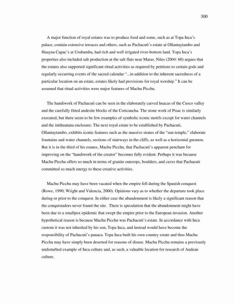
298
Chapter 11
Machu Picchu Region
11.1 Introduction
Machu Picchu has been variously described as a Citadel (Bingham, 1930), a Lost City (Bingham,
1948), a royal estate (Rowe, 1990), and a sacred center (Reinhard, 2002). Machu Picchu was
recognized by the Incas as a place of power, inpart because of its many granite outcrops and
caves and the cardinality of mountains such as Veronica, Huayna Picchu, Pumasillo, and the
snow peak of Salcantay. Salazar (2004) notes the large number of shrines at Machu Picchu,
similar to the huacas that surround Cusco, and acknowledges that there are more such shrines at
Machu Picchu than are found at other royals estates such as Pisac, Chinchero, Huamanmarcha,
and Callachaca.
Machu Picchu may also have been the focal point of a regional pilgrimage center that included
Llactapata (Figure 11-1). Pilgrimage is discussed in section 5.17.
299
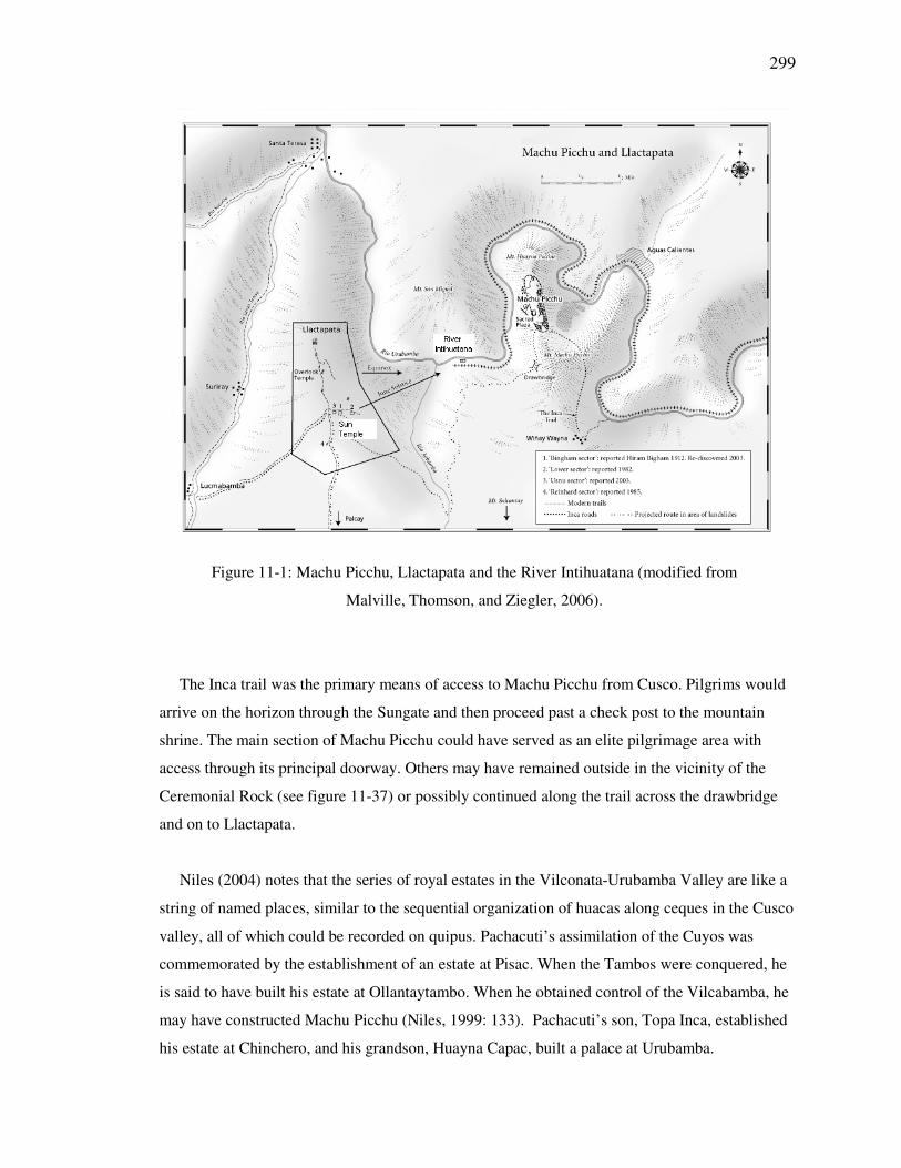
Figure 11-1: Machu Picchu, Llactapata and the River Intihuatana (modified from
Malville, Thomson, and Ziegler, 2006).
The Inca trail was the primary means of access to Machu Picchu from Cusco. Pilgrims would
arrive on the horizon through the Sungate and then proceed past a check post to the mountain
shrine. The main section of Machu Picchu could have served as an elite pilgrimage area with
access through its principal doorway. Others may have remained outside in the vicinity of the
Ceremonial Rock (see figure 11-37) or possibly continued along the trail across the drawbridge
and on to Llactapata.
Niles (2004) notes that the series of royal estates in the Vilconata-Urubamba Valley are like a
string of named places, similar to the sequential organization of huacas along ceques in the Cusco
valley, all of which could be recorded on quipus. Pachacuti’s assimilation of the Cuyos was
commemorated by the establishment of an estate at Pisac. When the Tambos were conquered, he
is said to have built his estate at Ollantaytambo. When he obtained control of the Vilcabamba, he
may have constructed Machu Picchu (Niles, 1999: 133). Pachacuti’s son, Topa Inca, established
his estate at Chinchero, and his grandson, Huayna Capac, built a palace at Urubamba.
300
A major function of royal estates was to produce food and some, such as at Topa Inca’s
palace, contain extensive terraces and others, such as Pachacuti’s estate at Ollantaytambo and
Huayna Capac’s at Urubamba, had rich and well irrigated river-bottom land. Topa Inca’s
properties also included salt production at the salt flats near Maras. Niles (2004: 60) argues that
the estates also supported significant ritual activities as required by petitions to certain gods and
regularly occurring events of the sacred calendar “...in addition to the inherent sacredness of a
particular location on an estate, estates likely had provisions for royal worship.” It can be
assumed that ritual activities were major features of Machu Picchu.
The handiwork of Pachacuti can be seen in the elaborately carved huacas of the Cusco valley
and the carefully fitted andesite blocks of the Coricancha. The stone work of Pisac is similarly
executed, but there seem to be few examples of symbolic iconic motifs except for water channels
and the intihuatana enclosure. The next royal estate to be established by Pachacuti,
Ollantaytambo, exhibits iconic features such as the massive stones of the “sun temple,” elaborate
fountains and water channels, sections of stairways in the cliffs, as well as a horizontal gnomon.
But it is in the third of his estates, Machu Picchu, that Pachacuti’s apparent penchant for
improving on the “handiwork of the creator” becomes fully evident. Perhaps it was because
Machu Picchu offers so much in terms of granite outcrops, boulders, and caves that Pachacuti
committed so much energy to these creative activities.
Machu Picchu may have been vacated when the empire fell during the Spanish conquest
(Rowe, 1990; Wright and Valencia, 2000). Opinions vary as to whether the departure took place
during or prior to the conquest. In either case the abandonment is likely a significant reason that
the conquistadors never found the site. There is speculation that the abandonment might have
been due to a smallpox epidemic that swept the empire prior to the European invasion. Another
hypothetical reason is because Machu Picchu was Pachacuti’s estate. In accordance with Inca
custom it was not inherited by his son, Topa Inca, and instead would have become the
responsibility of Pachacuti’s panaca. Topa Inca built his own country estate and thus Machu
Picchu may have simply been deserted for reasons of disuse. Machu Picchu remains a previously
undisturbed example of Inca culture and, as such, a valuable location for research of Andean
culture.
301
11.1.1 Architectural Plan and Engineering
The site for Machu Picchu lies some 500 meters above the Urubamba River between two reverse
faults that have given it the drop down area between them. Fracturing at the faults created
building material for Inca masons and facilitated the spring necessary for the site’s water supply
(Wright and Valencia, 2000). When selecting this location Pachacuti would have been impressed
by the magnificent views of several sacred mountains.
The estate appears to have been carefully planned and was likely built with mitmae workers.
Like Cusco, Machu Picchu was divided into hanan and hurin sectors, and also included a separate
agricultural sector on higher terrain immediately to the south (Gasparini & Margolies 1980).
Principal temples and palaces were constructed in the hanan sector.
Extensive agricultural terraces were built above and below Machu Picchu. These were
constructed for erosion control, aesthetic appeal, and crop production. The terraces were not
capable of producing enough to feed the site’s population, thus the majority of food products
were brought in from below (Wright and Valencia, 2000).
11.1.2 Ceques, Axes, and Sight-lines
The large number of huacas in Machu Picchu is reminiscent of the concentration of huacas near
the Coricancha of Cusco, where 41 ceques originate. Juan Polo de Ondegardo (1965: 67 [1571])
wrote “In each village the organization was the same; the district was crosscut by ceques and
lines connecting shrines or various consecrations and all the things which seem notable: wells and
springs and stones, hollows and valleys and summits which they call apachetas.” Ceques have
many interpretations, one of which is that of visual alignments. One hypothesis is that ceques
may have existed at Machu Picchu and a potential such orientation involves Machu Picchu,
Llactapata, and the River Intihuatana.
The River Intihuatana lies below the intersection of two major axes (see Figure 11-1). The first
is a solar axis formed between the horizon points of the June solstice sunrise and December
solstice sunset, which includes Llactapata’s Sun Temple and Machu Picchu’s Sacred Plaza. The
second is an east-west axis proceeding directly from Llactapata’s Overlook Temple across the
302
River Intihuatana and on to Cerro Machu Picchu. It remains possible that the River Intihuatana’s
location relates directly to these relationships and that the River Intihuatana may have been part
of a ceque connecting Machu Picchu with Llactapata. It is also a possibility that the precise
geographic location of the River Intihuatana at the junction of these axes or ceques was
intentional and that this may be a testament to the power and status of this huaca.
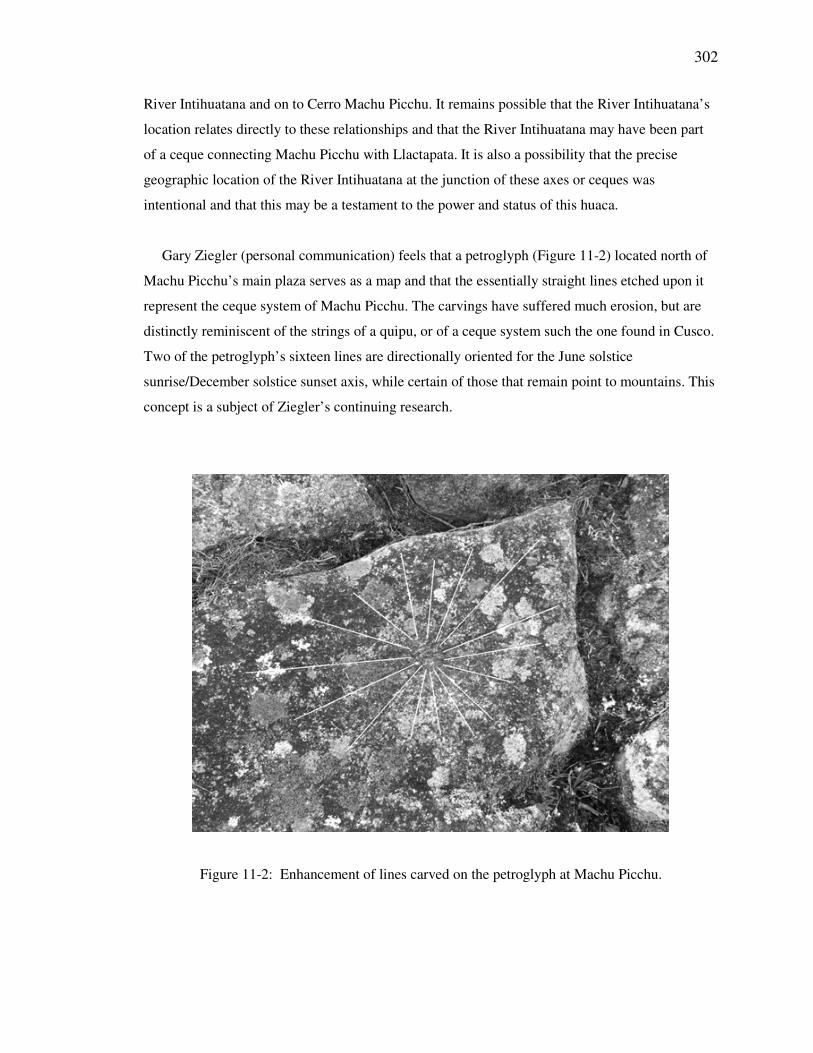
Gary Ziegler (personal communication) feels that a petroglyph (Figure 11-2) located north of
Machu Picchu’s main plaza serves as a map and that the essentially straight lines etched upon it
represent the ceque system of Machu Picchu. The carvings have suffered much erosion, but are
distinctly reminiscent of the strings of a quipu, or of a ceque system such the one found in Cusco.
Two of the petroglyph’s sixteen lines are directionally oriented for the June solstice
sunrise/December solstice sunset axis, while certain of those that remain point to mountains. This
concept is a subject of Ziegler’s continuing research.
Figure 11-2: Enhancement of lines carved on the petroglyph at Machu Picchu.
303
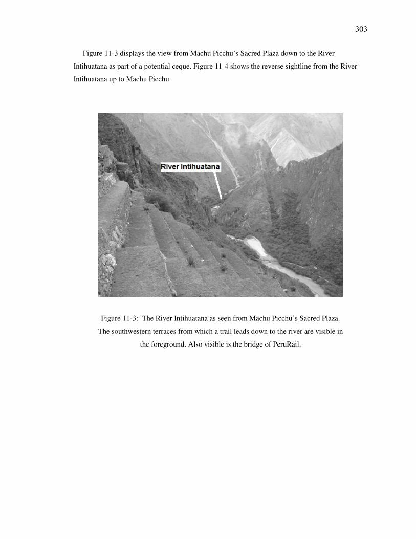
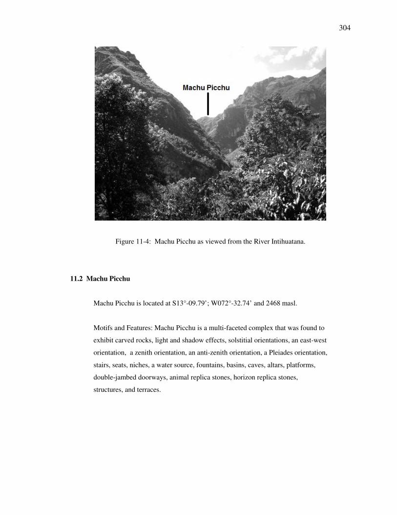
Figure 11-3 displays the view from Machu Picchu’s Sacred Plaza down to the River
Intihuatana as part of a potential ceque. Figure 11-4 shows the reverse sightline from the River
Intihuatana up to Machu Picchu.
Figure 11-3: The River Intihuatana as seen from Machu Picchu’s Sacred Plaza.
The southwestern terraces from which a trail leads down to the river are visible in
the foreground. Also visible is the bridge of PeruRail.
304
Figure 11-4: Machu Picchu as viewed from the River Intihuatana.
11.2 Machu Picchu
Machu Picchu is located at S13°-09.79’; W072°-32.74’ and 2468 masl.
Motifs and Features: Machu Picchu is a multi-faceted complex that was found to
exhibit carved rocks, light and shadow effects, solstitial orientations, an east-west
orientation, a zenith orientation, an anti-zenith orientation, a Pleiades orientation,
stairs, seats, niches, a water source, fountains, basins, caves, altars, platforms,
double-jambed doorways, animal replica stones, horizon replica stones,
structures, and terraces.
305
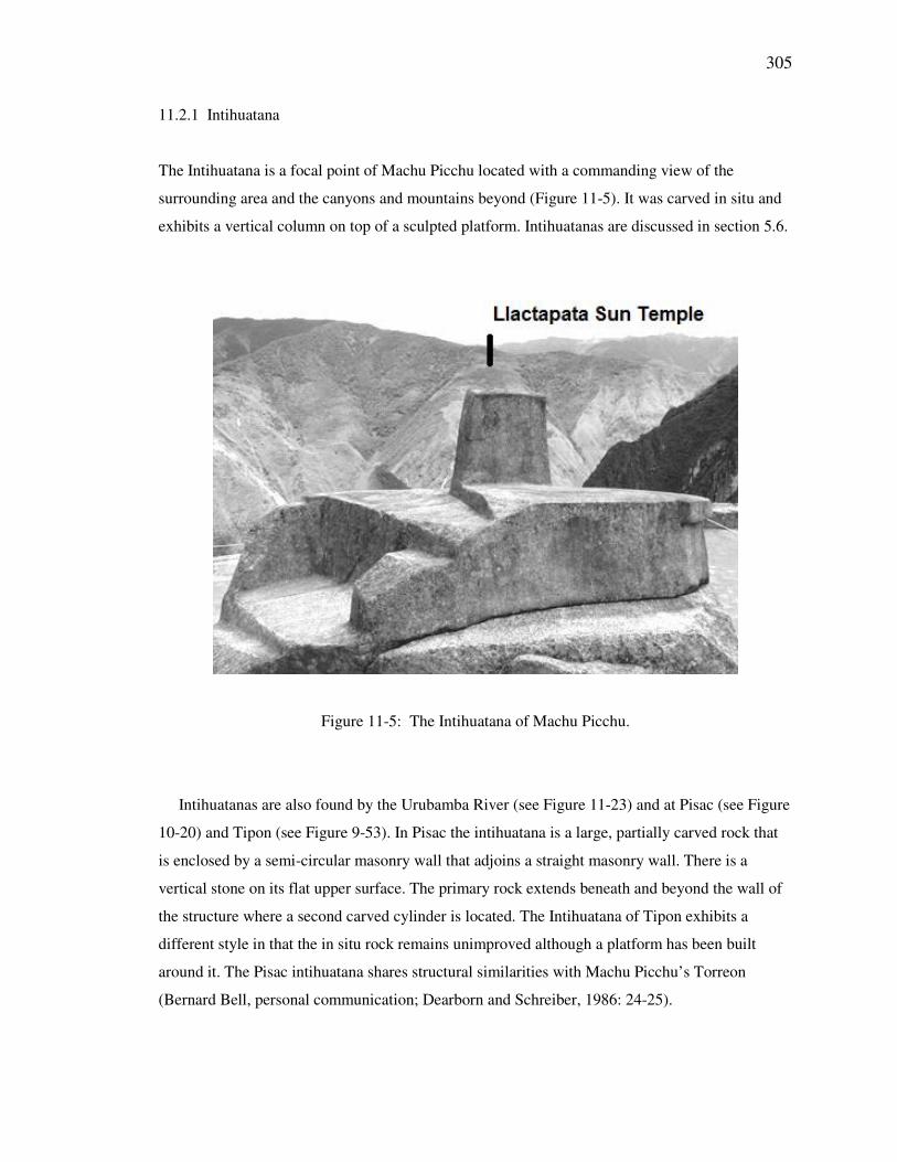
11.2.1 Intihuatana
The Intihuatana is a focal point of Machu Picchu located with a commanding view of the
surrounding area and the canyons and mountains beyond (Figure 11-5). It was carved in situ and
exhibits a vertical column on top of a sculpted platform. Intihuatanas are discussed in section 5.6.
Figure 11-5: The Intihuatana of Machu Picchu.
Intihuatanas are also found by the Urubamba River (see Figure 11-23) and at Pisac (see Figure
10-20) and Tipon (see Figure 9-53). In Pisac the intihuatana is a large, partially carved rock that
is enclosed by a semi-circular masonry wall that adjoins a straight masonry wall. There is a
vertical stone on its flat upper surface. The primary rock extends beneath and beyond the wall of
the structure where a second carved cylinder is located. The Intihuatana of Tipon exhibits a
different style in that the in situ rock remains unimproved although a platform has been built
around it. The Pisac intihuatana shares structural similarities with Machu Picchu’s Torreon
(Bernard Bell, personal communication; Dearborn and Schreiber, 1986: 24-25).
306
Evidence has not been found to indicate that Machu Picchu’s intihuatana served as an
astronomical observing instrument, but its unobstructed views may have made it valuable for
other observations. On an expedition with Dearborn, as viewed from the intihuatana, Bernard Bell
observed two pillar-like objects on San Miguel. These were not substantiated, but similar
observations might be a possibility from such a vantage point (Dearborn and White, 1982).
The Intihuatana was built upon the highest point in Machu Picchu’s urban sector and is
positioned well for visual alignments with Llactapata and the River Intihuatana by the Urubamba.
Llactapata is inclinated at 2.0° at a true azimuth of 241.2°. The River Huaca has an inclination of
-20.0° on a 225.7° true azimuth. The June solstice sunrise is easily viewed from the Intihuatana
inclined 13.0° up on a 061.2° true azimuth, as shown below. Machu Picchu’s Intihuatana is
located at S13-09.79°; W072-32.74° and 2468 masl.
Calculated azimuth of June solstice sunrise from the intihuatana
Measured azimuth from the intihuatana to observed point of June solstice sunrise on the horizon
Measured Azimuth: 064.5°
Magnetic Declination: 3.3° W
True Azimuth: 061.2°
Calculated JSSR Azimuth: 061.8°
∆ Calc JSSR Az & True Az: 0.6°
Measured Inclination: +13.0°
307
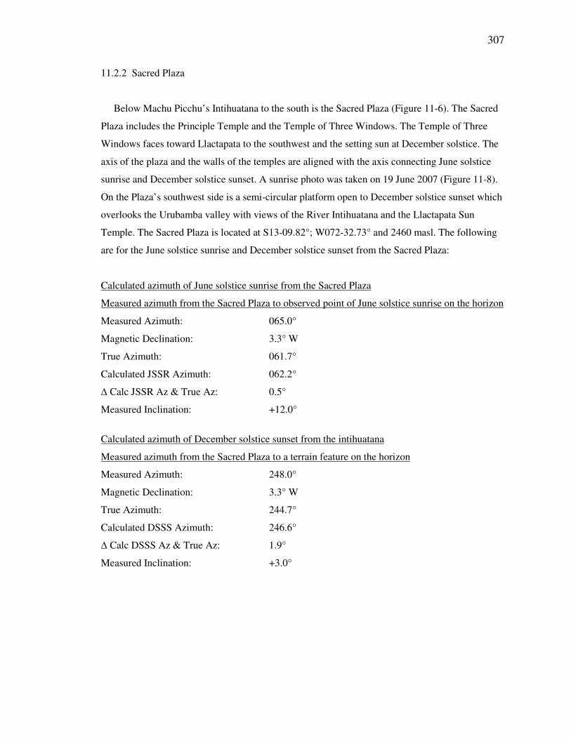
11.2.2 Sacred Plaza
Below Machu Picchu’s Intihuatana to the south is the Sacred Plaza (Figure 11-6). The Sacred
Plaza includes the Principle Temple and the Temple of Three Windows. The Temple of Three
Windows faces toward Llactapata to the southwest and the setting sun at December solstice. The
axis of the plaza and the walls of the temples are aligned with the axis connecting June solstice
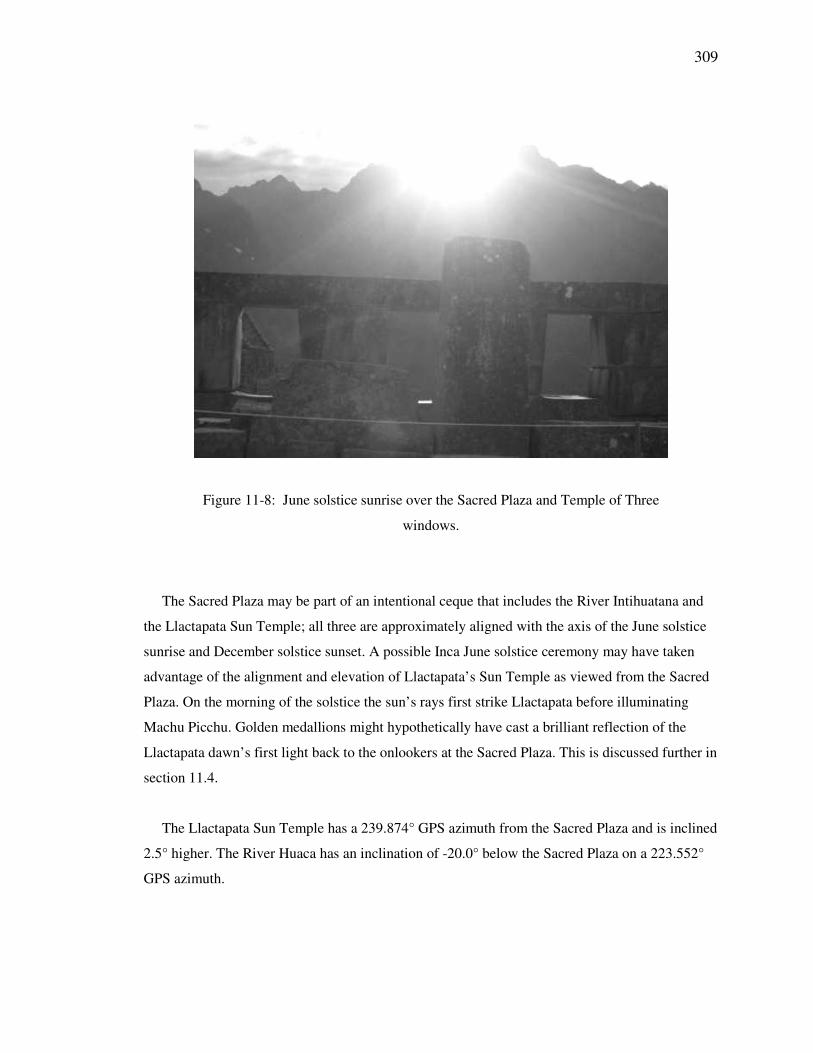
sunrise and December solstice sunset. A sunrise photo was taken on 19 June 2007 (Figure 11-8).
On the Plaza’s southwest side is a semi-circular platform open to December solstice sunset which
overlooks the Urubamba valley with views of the River Intihuatana and the Llactapata Sun
Temple. The Sacred Plaza is located at S13-09.82°; W072-32.73° and 2460 masl. The following
are for the June solstice sunrise and December solstice sunset from the Sacred Plaza:
Calculated azimuth of June solstice sunrise from the Sacred Plaza
Measured azimuth from the Sacred Plaza to observed point of June solstice sunrise on the horizon
Measured Azimuth: 065.0°
Magnetic Declination: 3.3° W
True Azimuth: 061.7°
Calculated JSSR Azimuth: 062.2°
∆ Calc JSSR Az & True Az: 0.5°
Measured Inclination: +12.0°
Calculated azimuth of December solstice sunset from the intihuatana
Measured azimuth from the Sacred Plaza to a terrain feature on the horizon
Measured Azimuth: 248.0°
Magnetic Declination: 3.3° W
True Azimuth: 244.7°
Calculated DSSS Azimuth: 246.6°
∆ Calc DSSS Az & True Az: 1.9°
Measured Inclination: +3.0°
308
Figure 11-6: Machu Picchu’s Sacred Plaza orientations
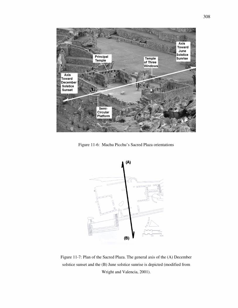
Figure 11-7: Plan of the Sacred Plaza. The general axis of the (A) December
solstice sunset and the (B) June solstice sunrise is depicted (modified from
Wright and Valencia, 2001).
309
Figure 11-8: June solstice sunrise over the Sacred Plaza and Temple of Three
windows.
The Sacred Plaza may be part of an intentional ceque that includes the River Intihuatana and
the Llactapata Sun Temple; all three are approximately aligned with the axis of the June solstice
sunrise and December solstice sunset. A possible Inca June solstice ceremony may have taken
advantage of the alignment and elevation of Llactapata’s Sun Temple as viewed from the Sacred
Plaza. On the morning of the solstice the sun’s rays first strike Llactapata before illuminating
Machu Picchu. Golden medallions might hypothetically have cast a brilliant reflection of the
Llactapata dawn’s first light back to the onlookers at the Sacred Plaza. This is discussed further in
section 11.4.
The Llactapata Sun Temple has a 239.874° GPS azimuth from the Sacred Plaza and is inclined
2.5° higher. The River Huaca has an inclination of -20.0° below the Sacred Plaza on a 223.552°
GPS azimuth.
310
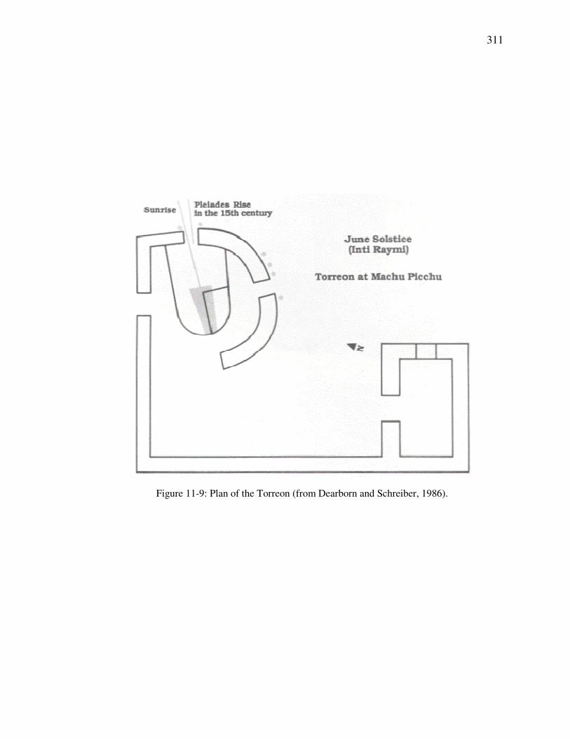
11.2.3 Torreon, Royal Mausoleum, Temple of the Sun
The Torreon/Royal Mausoleum was one of the major shrines of Machu Picchu (Figure 11-10).
Very fine masonry crowns the top where it was carefully fitted into the rock with a wall that
includes a window open to the horizon positions of the June solstice sunrise and the heliacal rise
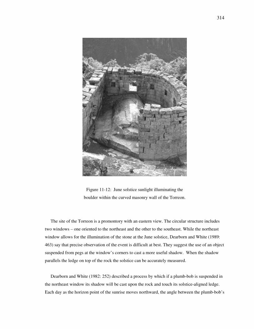
of the Pleiades. A stone surrounded by the walled enclosure is illuminated through the window at
sunrise during the time of the June solstice (Figure 11-12). A ledge cut into the top of the stone
nearly bisects the early rays of the solstice sun (Dearborn and Schreiber, 1986: 22-23).
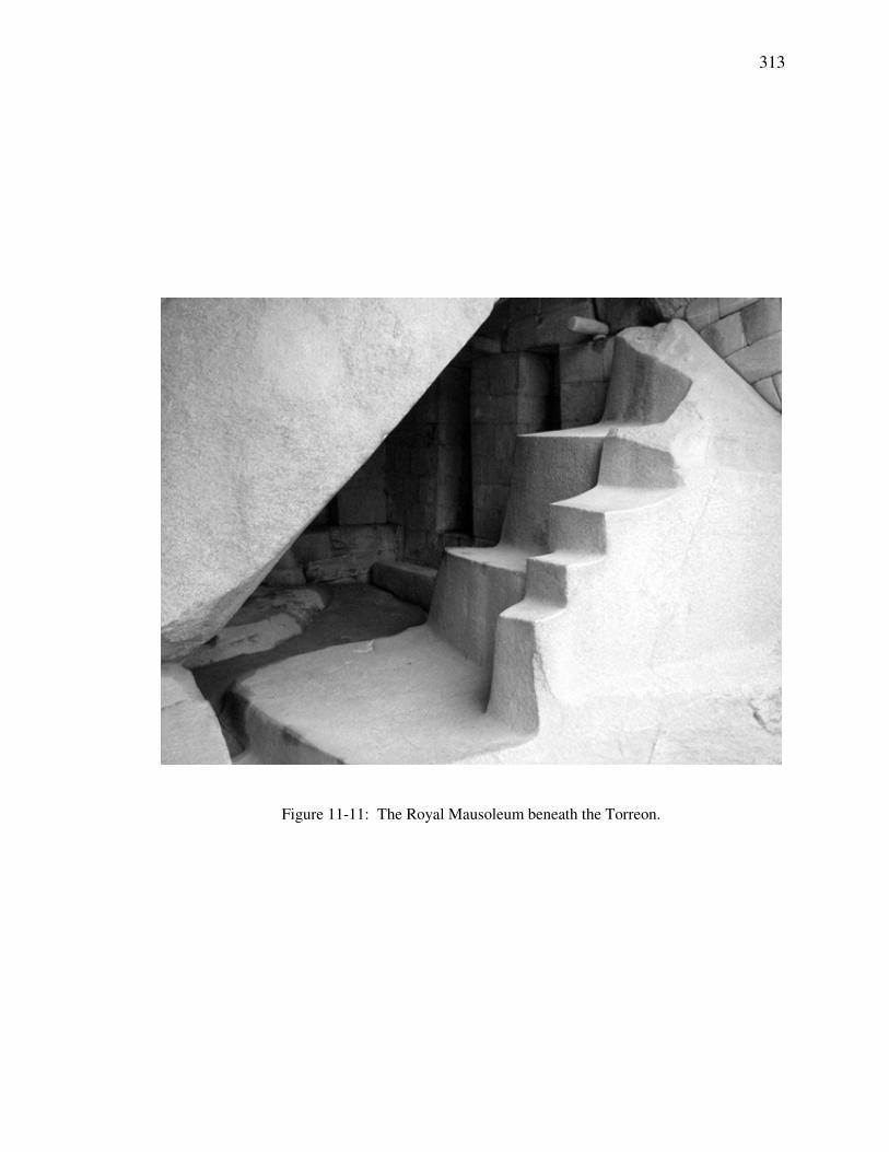
Below the Torreon is the Royal Mausoleum, a cave which contains a set of symbolic stairs,
niches, and other stonework (Figure 11-11). The cave gives the impression of a passageway to the
underworld and the carved, stepped stone a shamanic stairway of ascent. The proximity of the
Torreon to the major fountains of Machu Picchu is consistent with the importance of water in the
symbolic meaning of rock.
Research at Pisac’s Intihuatana (see Figure 10-20) revealed a structure with certain similarities
to the Torreon (Dearborn and Schreiber, 1986: 24-25). Comparisons have also been made
between the Torreon and the Coricancha with regard to Pleiades observations. The respective
horizon points of the June solstice sunrise and the heliacal rise of the Pleiades are both visible
through the Torreon’s northeastern window. Dearborn and White (1989: 466) found the window
to be more closely aligned with the Pleiades, while the ledge on the rock is oriented for the
solstice (Figure 11-9).
311
Figure 11-9: Plan of the Torreon (from Dearborn and Schreiber, 1986).
312
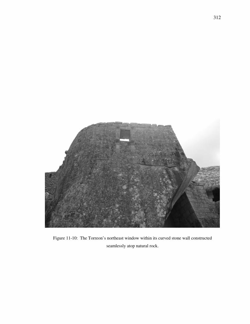
Figure 11-10: The Torreon’s northeast window within its curved stone wall constructed
seamlessly atop natural rock.
313
Figure 11-11: The Royal Mausoleum beneath the Torreon.
314
Figure 11-12: June solstice sunlight illuminating the
boulder within the curved masonry wall of the Torreon.
The site of the Torreon is a promontory with an eastern view. The circular structure includes
two windows – one oriented to the northeast and the other to the southeast. While the northeast
window allows for the illumination of the stone at the June solstice, Dearborn and White (1989:
463) say that precise observation of the event is difficult at best. They suggest the use of an object
suspended from pegs at the window’s corners to cast a more useful shadow. When the shadow
parallels the ledge on top of the rock the solstice can be accurately measured.
Dearborn and White (1982: 252) described a process by which if a plumb-bob is suspended in
the northeast window its shadow will be cast upon the rock and touch its solstice-aligned ledge.
Each day as the horizon point of the sunrise moves northward, the angle between the plumb-bob’s
315
shadow and the ledge becomes smaller until they meet on the day of the solstice. If the string is
positioned carefully (which is not in the center of the window) the shadow will align with the
boulder’s ledge, but the ledge was not carved so that it could have been used as a direct sighting
device. Further research is required to determine if this procedure was used by the Incas during
the 15th and 16
th centuries.
Dearborn and White (1982: 253) also describe a method for using the Torreon to indicate the
time of zenith passage. This procedure utilizes both the northeast and the southeast windows.
Light at sunrise passes through the northeast window from February through October and the
southeast window from October through February. At the end of either period illumination at
dawn enters both windows at the same time for about five or six days. Dearborn and White state
that the time of zenith passage could be identified by observing the area illuminated through both
windows.
316
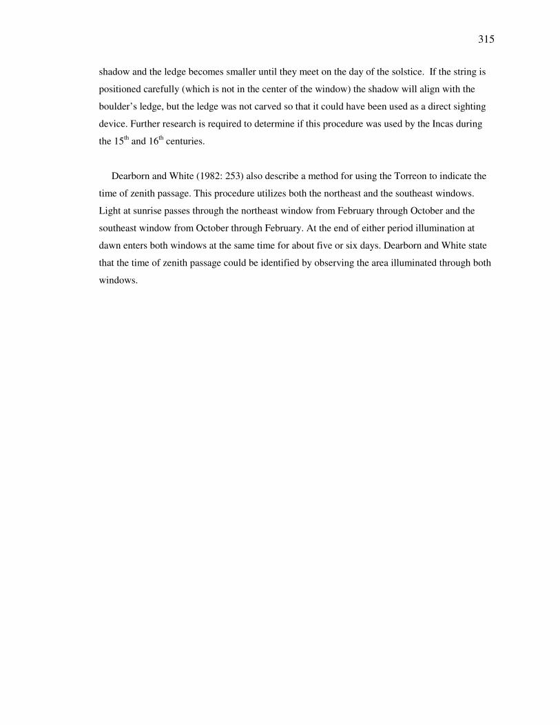
11.2.4 The Mortars
Carvings called The Mortars, located within a building in the Eastern Urban Sector, proved to be
of interest (Figure 11-13). They are two carved shallow basins situated on a floor surrounded by
walls and are oriented such that on the day of an equinox mid-morning sunlight will pass thru an
adjacent window (to the right of the mortars in Figure 11-13) and cast a reflection off the water
within the northern mortar basin. The two mortars are aligned approximately north and south with
respect to one another. The photo in Figure 11-13 was taken at noon on 19 June 2007, but this
date is is not related to the discussion.
Figure 11-13: The sun’s reflection in the southern mortar.
Water-filled basins might have been used for indirect viewing of the sun and moon. The
building has been depicted without a roof (Wright and Valencia, 2001). The walls surrounding
the mortars are lined with niches, perhaps for religious artifacts. The Southern Cross is one of the
most prominent constellations in the southern sky and therefore draws attention in the direction of
317
south. Zuidema (1982a: 218) describes Inca interest in the Southern Cross and argues that in
Cusco the 14th ceque of Cuntisuyu was aligned to indicate the direction of the rising of the
constellation.
The window adjacent to the mortars is aligned to 073.7° true azimuth. The bearing from the
north mortar through the window is 080.2° and from the south mortar it is 060.7°. The inclination
from the north mortar to the bottom of the window is 33.0° and to its top is 38.0°. The mortars are
located at S13-09.80°; W072-32.67°.
Calculated azimuth of equinox sunrise from the mortars
Measured azimuth from the north mortar across the window bottom center to the horizon
Measured Azimuth: 083.5°
Magnetic Declination: 3.3° W
True Azimuth: 080.2°
Calculated ESR Azimuth: 081.8°
∆ Calc ESR Az & True Az: 1.6°
Measured Inclination: +33.0°
318
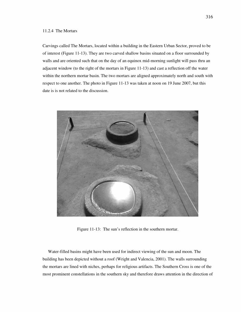
11.2.5 Intimachay
Also in the Eastern Urban Sector lies a cave called the Intimachay. Dearborn, Schreiber and
White (1987: 349) argue that this cave was constructed to observe sunrise at the time of the
December solstice and the festival of Capac Raymi. A tunnel, like a horizontal light-tube, (Figure
11-14) was oriented to admit sunlight to the cave for about 10 days before and after the solstice. It
was aligned so as to cast a shaft of light to the back of the cave during this period. The window
did not function to illuminate the cave, but instead was aligned precisely with the December
solstice sunrise (Dearborn and White, 1989: 467). The view of the horizon was constrained by an
interior stone that limited the field of view to 10 arc-minutes. Reconstruction performed in 2006
narrowed the window and presently inhibits direct view of the horizon from the cave’s interior.
Capac Raymi was a festival celebrated by the nobility that included ceremonies of passage to
manhood for young Inca noblemen (Cobo, 1983 [1653]: 126-134). A site such as this could have
played a role.
Figure 11-14: The tunnel of the Intimachay.
319
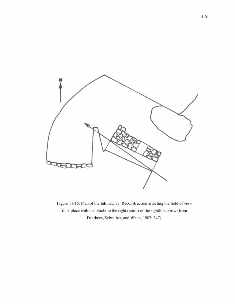
Figure 11-15: Plan of the Intimachay. Reconstruction affecting the field of view
took place with the blocks to the right (north) of the sightline arrow (from
Dearborn, Schreiber, and White, 1987: 347).
320
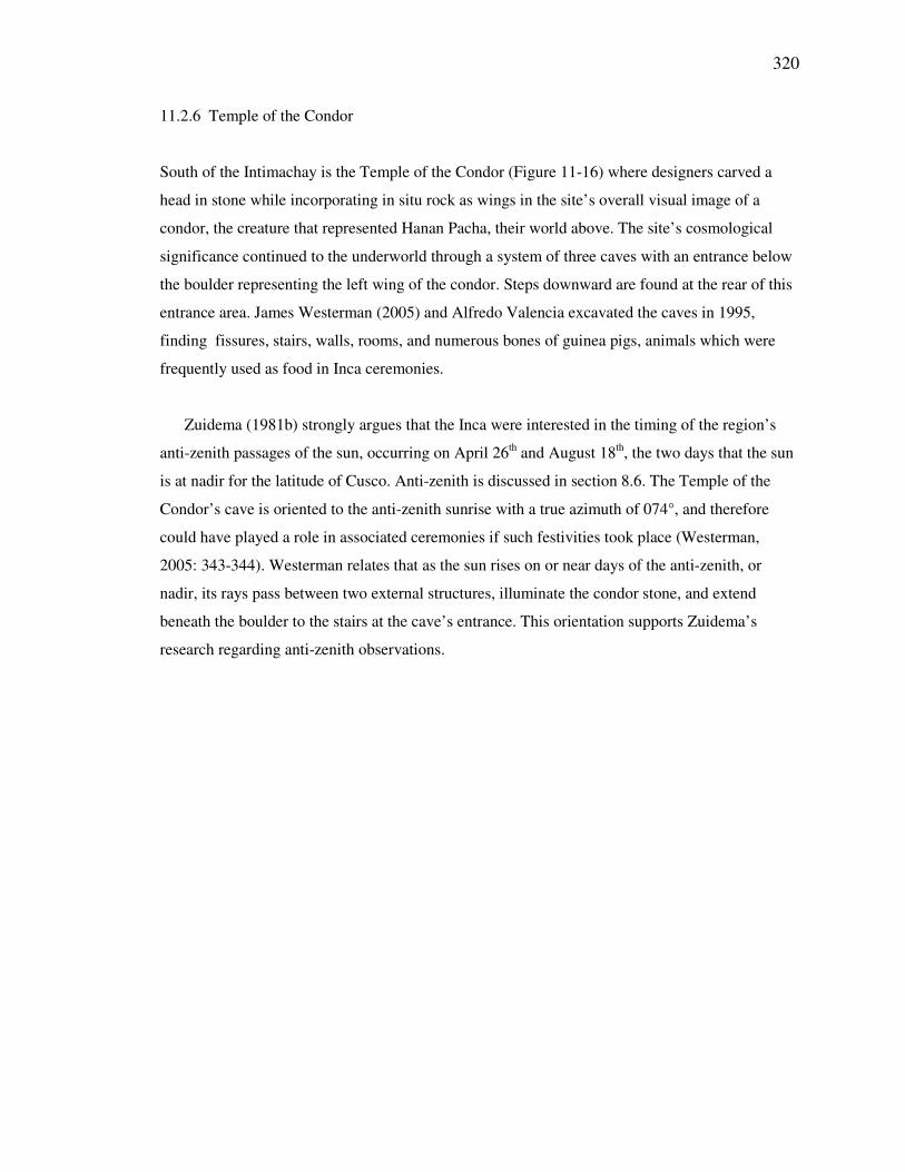
11.2.6 Temple of the Condor
South of the Intimachay is the Temple of the Condor (Figure 11-16) where designers carved a
head in stone while incorporating in situ rock as wings in the site’s overall visual image of a
condor, the creature that represented Hanan Pacha, their world above. The site’s cosmological
significance continued to the underworld through a system of three caves with an entrance below
the boulder representing the left wing of the condor. Steps downward are found at the rear of this
entrance area. James Westerman (2005) and Alfredo Valencia excavated the caves in 1995,
finding fissures, stairs, walls, rooms, and numerous bones of guinea pigs, animals which were
frequently used as food in Inca ceremonies.
Zuidema (1981b) strongly argues that the Inca were interested in the timing of the region’s
anti-zenith passages of the sun, occurring on April 26th and August 18
th, the two days that the sun
is at nadir for the latitude of Cusco. Anti-zenith is discussed in section 8.6. The Temple of the
Condor’s cave is oriented to the anti-zenith sunrise with a true azimuth of 074°, and therefore
could have played a role in associated ceremonies if such festivities took place (Westerman,
2005: 343-344). Westerman relates that as the sun rises on or near days of the anti-zenith, or
nadir, its rays pass between two external structures, illuminate the condor stone, and extend
beneath the boulder to the stairs at the cave’s entrance. This orientation supports Zuidema’s
research regarding anti-zenith observations.
321
Figure 11-16: Condor stone and cave entrance in the Temple of the Condor.
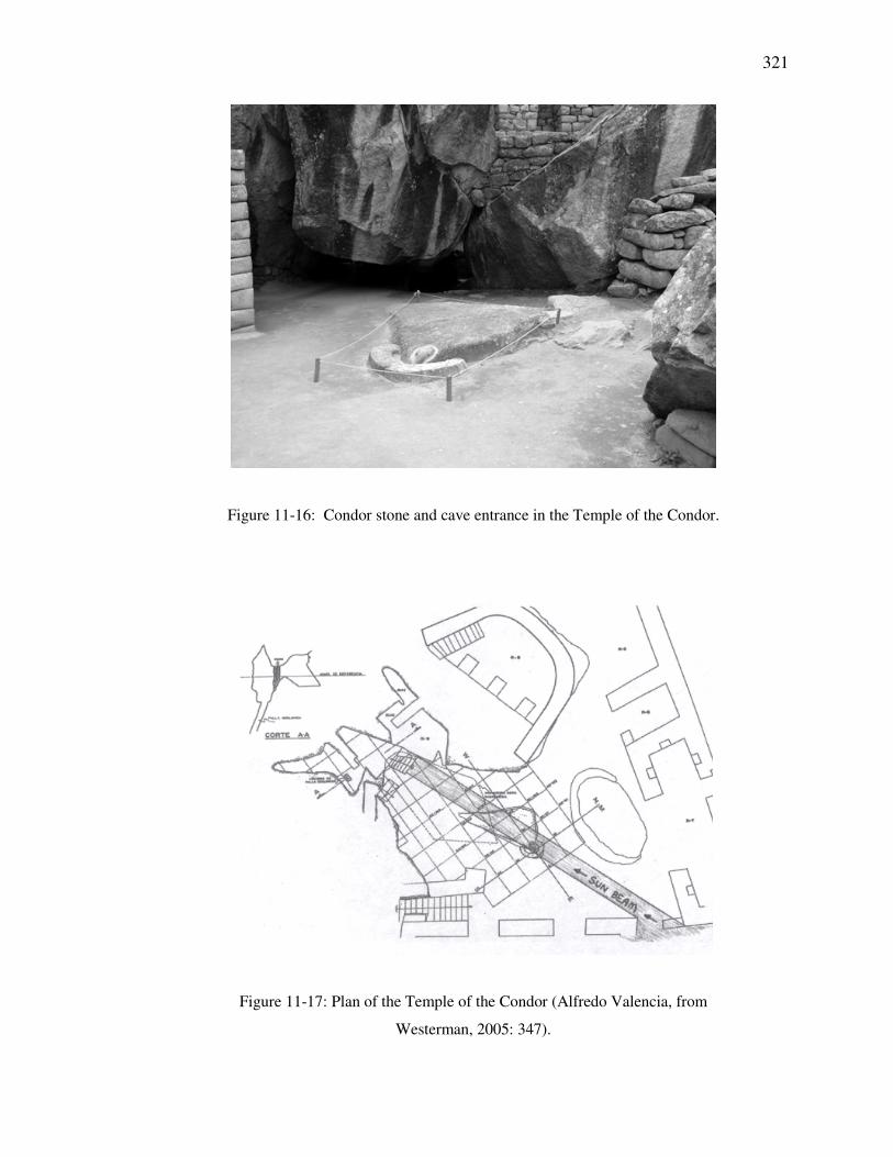
Figure 11-17: Plan of the Temple of the Condor (Alfredo Valencia, from
Westerman, 2005: 347).
322
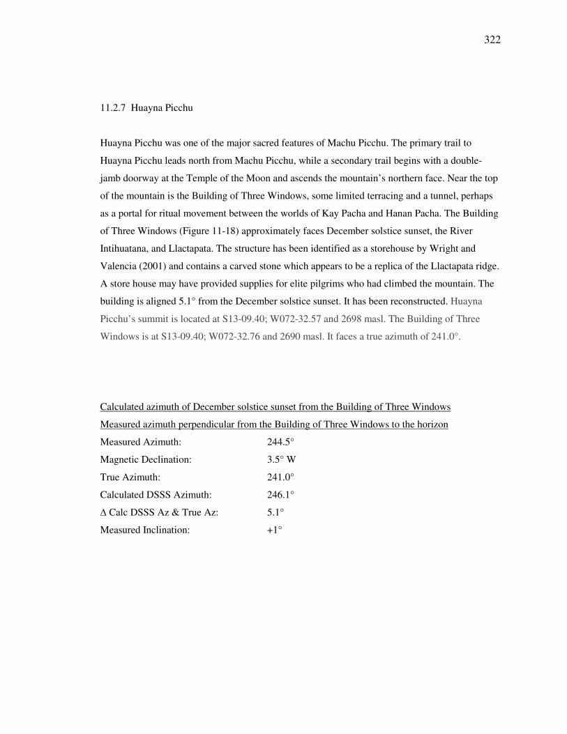
11.2.7 Huayna Picchu
Huayna Picchu was one of the major sacred features of Machu Picchu. The primary trail to
Huayna Picchu leads north from Machu Picchu, while a secondary trail begins with a double-
jamb doorway at the Temple of the Moon and ascends the mountain’s northern face. Near the top
of the mountain is the Building of Three Windows, some limited terracing and a tunnel, perhaps
as a portal for ritual movement between the worlds of Kay Pacha and Hanan Pacha. The Building
of Three Windows (Figure 11-18) approximately faces December solstice sunset, the River
Intihuatana, and Llactapata. The structure has been identified as a storehouse by Wright and
Valencia (2001) and contains a carved stone which appears to be a replica of the Llactapata ridge.
A store house may have provided supplies for elite pilgrims who had climbed the mountain. The
building is aligned 5.1° from the December solstice sunset. It has been reconstructed. Huayna
Picchu’s summit is located at S13-09.40; W072-32.57 and 2698 masl. The Building of Three
Windows is at S13-09.40; W072-32.76 and 2690 masl. It faces a true azimuth of 241.0°.
Calculated azimuth of December solstice sunset from the Building of Three Windows
Measured azimuth perpendicular from the Building of Three Windows to the horizon
Measured Azimuth: 244.5°
Magnetic Declination: 3.5° W
True Azimuth: 241.0°
Calculated DSSS Azimuth: 246.1°
∆ Calc DSSS Az & True Az: 5.1°
Measured Inclination: +1°

323
Figure 11-18: The view of the Urubamba River canyon and the Llactapata ridge
from above the Building of Three Windows near the top of Huayna Picchu.
324
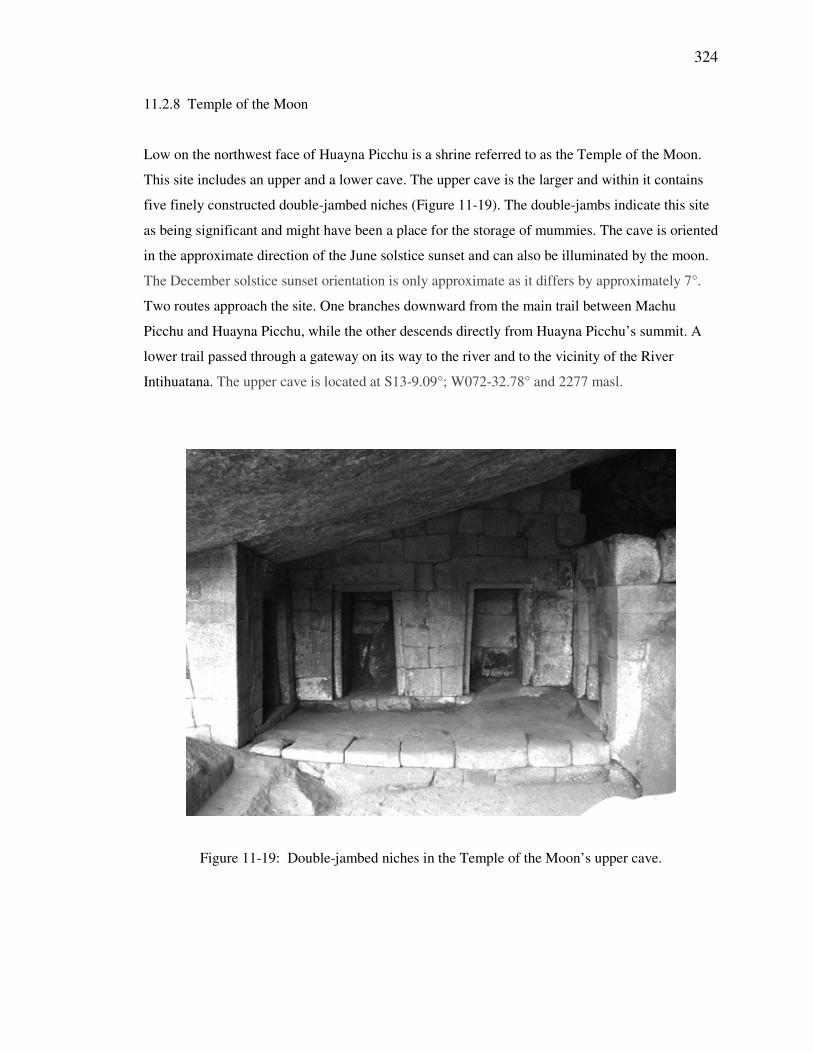
11.2.8 Temple of the Moon
Low on the northwest face of Huayna Picchu is a shrine referred to as the Temple of the Moon.
This site includes an upper and a lower cave. The upper cave is the larger and within it contains
five finely constructed double-jambed niches (Figure 11-19). The double-jambs indicate this site
as being significant and might have been a place for the storage of mummies. The cave is oriented
in the approximate direction of the June solstice sunset and can also be illuminated by the moon.
The December solstice sunset orientation is only approximate as it differs by approximately 7°.
Two routes approach the site. One branches downward from the main trail between Machu
Picchu and Huayna Picchu, while the other descends directly from Huayna Picchu’s summit. A
lower trail passed through a gateway on its way to the river and to the vicinity of the River
Intihuatana. The upper cave is located at S13-9.09°; W072-32.78° and 2277 masl.
Figure 11-19: Double-jambed niches in the Temple of the Moon’s upper cave.
325
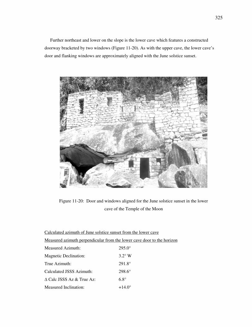
Further northeast and lower on the slope is the lower cave which features a constructed
doorway bracketed by two windows (Figure 11-20). As with the upper cave, the lower cave’s
door and flanking windows are approximately aligned with the June solstice sunset.
Figure 11-20: Door and windows aligned for the June solstice sunset in the lower
cave of the Temple of the Moon
Calculated azimuth of June solstice sunset from the lower cave
Measured azimuth perpendicular from the lower cave door to the horizon
Measured Azimuth: 295.0°
Magnetic Declination: 3.2° W
True Azimuth: 291.8°
Calculated JSSS Azimuth: 298.6°
∆ Calc JSSS Az & True Az: 6.8°
Measured Inclination: +14.0°
326
11.3 River Intihuatana
The River Intihuatana is located at S13°-10.54’; W072°-33.44’ and 1819 masl.
Motifs and Features: The River Intihuatana is a multi-faceted complex that was
found to exhibit carved rocks, east-west orientations, a potential zenith
orientation, stairs, niches, a water source, fountains, basins, caves, a platform, a
carved cylinder, structures and terraces.
During his exploration of the Vilcabamba, Hiram Bingham located two carved rocks that he
identified as intihuatanas. One of these, the Intihuatana of Machu Picchu, is arguably the best
known carved rock of the Inca world. The second intihuatana, lying deep in the Urubamba
canyon to the west of Machu Picchu, has been visited far less frequently. When examined this
shrine was found to be rich with cosmological symbolism. The River Intihuatana is an important
element of the extended ceremonial complex that combines Machu Picchu with sites on the
Llactapata ridge. It is located on a hillside between PeruRail switchbacks near a hydroelectric
complex (see Figure 11-1).
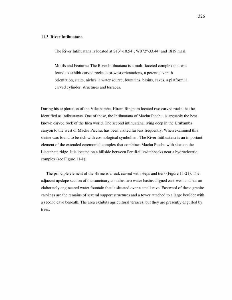
The principle element of the shrine is a rock carved with steps and tiers (Figure 11-21). The
adjacent upslope section of the sanctuary contains two water basins aligned east-west and has an
elaborately engineered water fountain that is situated over a small cave. Eastward of these granite
carvings are the remains of several support structures and a tower attached to a large boulder with
a second cave beneath. The area exhibits agricultural terraces, but they are presently engulfed by
trees.
327
Figure 11-21: Carlos Aranibar interviews Esteban Mayta, property owner, as they
sit on the River Intihuatana.
The significance of the River Intihuatana has become clearer since the rediscovery of the
Llactapata Sun Temple in 2003. The site can now be identified as a major shrine (a huaca
sanctuary) connected to Machu Picchu by two intersecting sightlines or ceques from the
Llactapata ridge. The concentration of symbolic motifs suggests ceremonial significance at the
site.
The massive carved stone lies close to the June solstice sunrise sightline as traced from the
Llactapata sun temple across the canyon and over Machu Picchu’s Sacred Plaza. The sanctuary
employs east-west sightlines and adjacent to the Intihuatana is a platform that provides views of
the Overlook Temple on the Llactapata ridge and the Intihuatana of Machu Picchu. The grounds
also include several common motifs found in other Incan huacas: a fountain, basins, symbolic
stairs, and caves.
328
The large number of huacas in Machu Picchu is reminiscent of the concentration of huacas
near the Coricancha of Cusco, where 41 ceques originate. Ceques have many interpretations, one
of which is that of visual alignments. A compelling such orientation involves the River
Intihuatana. The large granite rock includes a leveled platform that also provides views of the
Llactapata’s Overlook Temple and Machu Picchu’s Intihuatana. The location of the rock is
critical for its viewscape; if it had been located a few meters to the south, the view of the
Overlook Temple would have been blocked by canyon walls. The Machu Picchu Intihuatana is
clearly visible (see Figures 11-3, 11-4 and 11-22) and the base of the River Intihuatana’s carved
stone is oriented approximately in its direction.
The River Intihuatana lies above the Urubamba River hydroelectric compound that is situated
5 kilometers southwest of Aguas Calientes. The primary carved stone is located approximately 20
meters downslope (north) from the upper PeruRail tracks entering the area. About 30 meters
below the sanctuary platform is the mid set of tracks of the switchback and then the slope
continues downward to a final set of tracks and across to the hydroelectric compound and the
river.
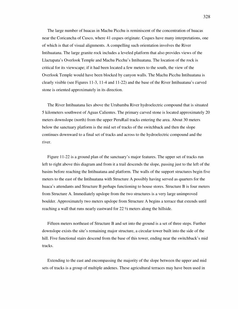
Figure 11-22 is a ground plan of the sanctuary’s major features. The upper set of tracks run
left to right above this diagram and from it a trail descends the slope, passing just to the left of the
basins before reaching the Intihuatana and platform. The walls of the support structures begin five
meters to the east of the Intihuatana with Structure A possibly having served as quarters for the
huaca’s attendants and Structure B perhaps functioning to house stores. Structure B is four meters
from Structure A. Immediately upslope from the two structures is a very large unimproved
boulder. Approximately two meters upslope from Structure A begins a terrace that extends until
reaching a wall that runs nearly eastward for 22 ½ meters along the hillside.
Fifteen meters northeast of Structure B and set into the ground is a set of three steps. Further
downslope exists the site’s remaining major structure, a circular tower built into the side of the
hill. Five functional stairs descend from the base of this tower, ending near the switchback’s mid
tracks.
Extending to the east and encompassing the majority of the slope between the upper and mid
sets of tracks is a group of multiple andenes. These agricultural terraces may have been used in
329
partial support of the huaca’s attendants, but currently are hidden by a thick expanse of trees. The
complex likely was clear when it was occupied some 500 years ago.
Figure 11-22: Ground plan of the River Intihuatana sanctuary.
11.3.1 Intihuatana
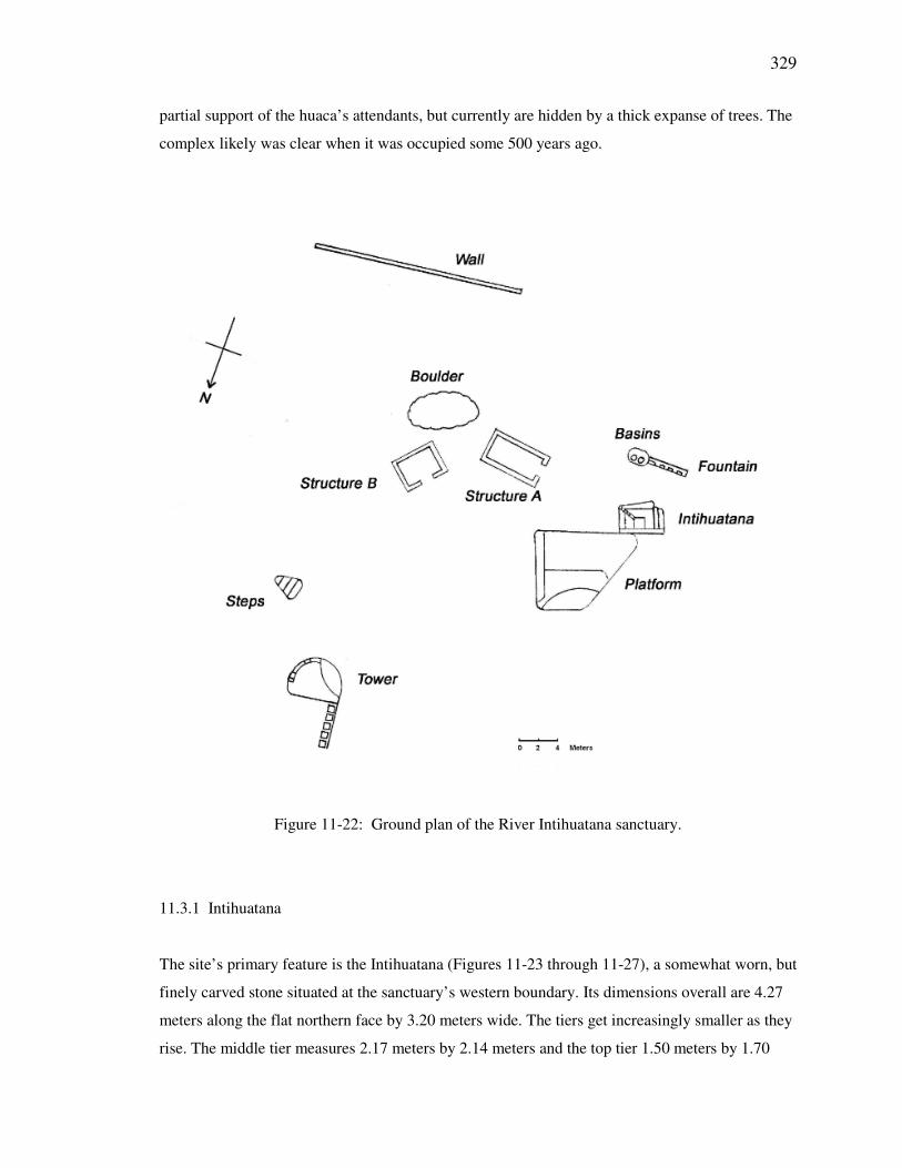
The site’s primary feature is the Intihuatana (Figures 11-23 through 11-27), a somewhat worn, but
finely carved stone situated at the sanctuary’s western boundary. Its dimensions overall are 4.27
meters along the flat northern face by 3.20 meters wide. The tiers get increasingly smaller as they
rise. The middle tier measures 2.17 meters by 2.14 meters and the top tier 1.50 meters by 1.70
330
meters. On the east side of the top tier is an intermediate level measuring 48 cm by 1.70 meters
and both are adjoined by a set of descending steps too small to serve any necessary function as
they are situated. There appears at present to be three steps, but the stone has been subject to
enough erosion to make the original number uncertain. The northern face of the Intihuatana is a
flat wall angled from the west toward the top. Its eastern side is also angled, but the surface is
broken, thus masking its original shape. The top of the northern face is flat and includes the
remains of a cylindrical carving. The base of the shrine is partially covered by soil and the
western edge of the area encompassing the Intihuatana and the fountain drops vertically along a
sheer stone face. The Intihuatana may also have had a higher portion that was broken by a
landslide.
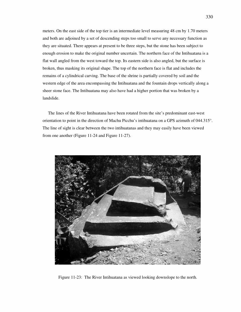
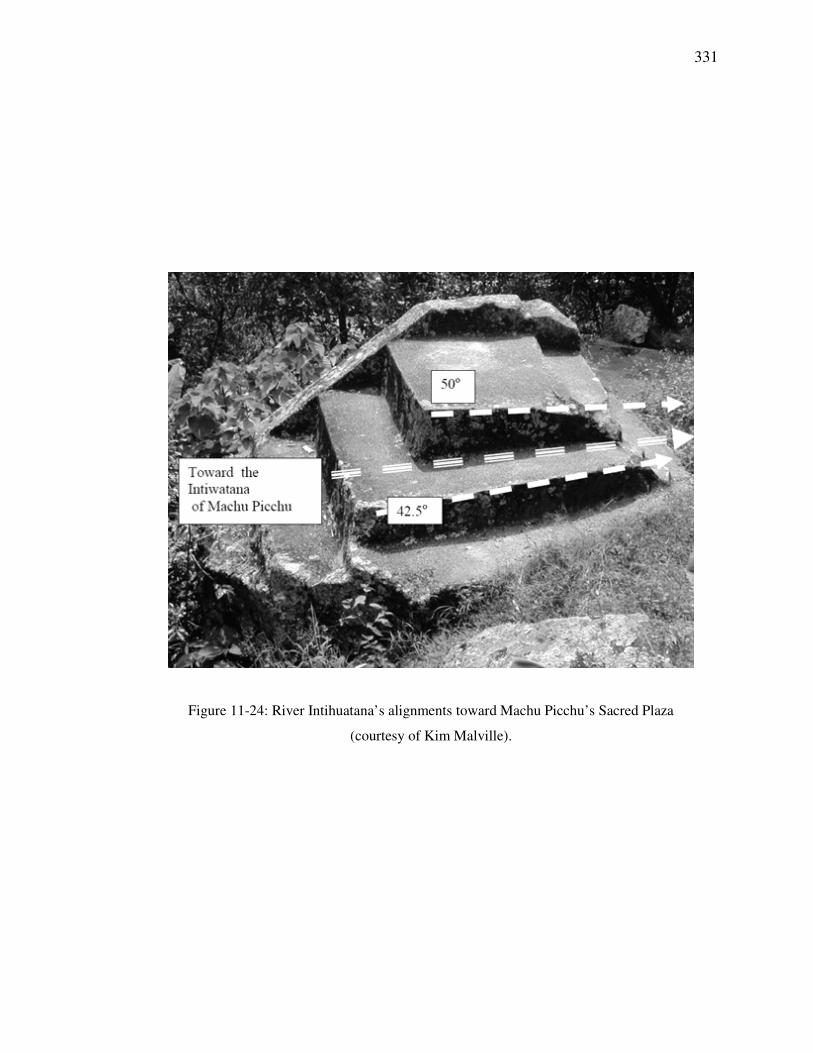
The lines of the River Intihuatana have been rotated from the site’s predominant east-west
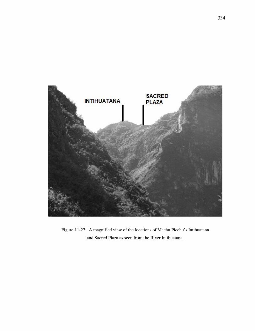
orientation to point in the direction of Machu Picchu’s intihuatana on a GPS azimuth of 044.315°.
The line of sight is clear between the two intihuatanas and they may easily have been viewed
from one another (Figure 11-24 and Figure 11-27).
Figure 11-23: The River Intihuatana as viewed looking downslope to the north.
331
Figure 11-24: River Intihuatana’s alignments toward Machu Picchu’s Sacred Plaza
(courtesy of Kim Malville).
332
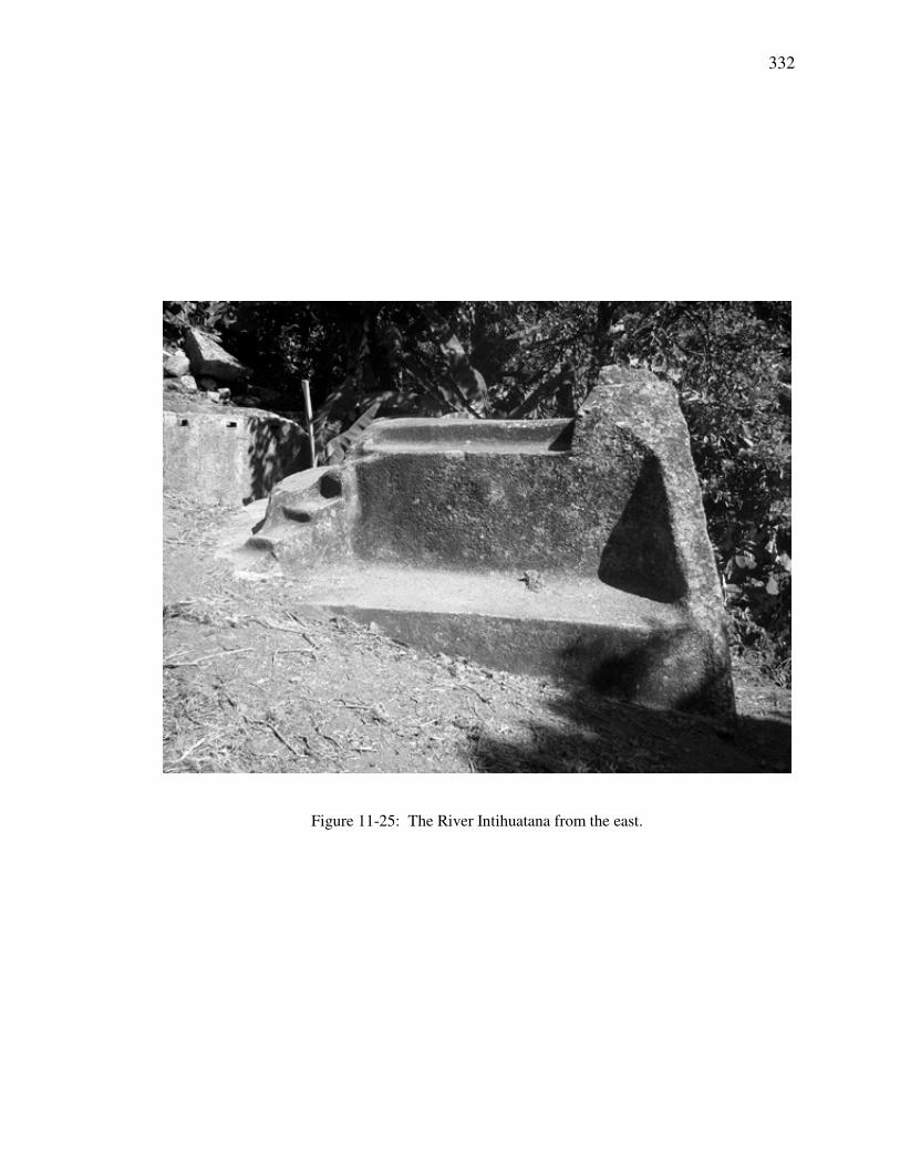
Figure 11-25: The River Intihuatana from the east.
333
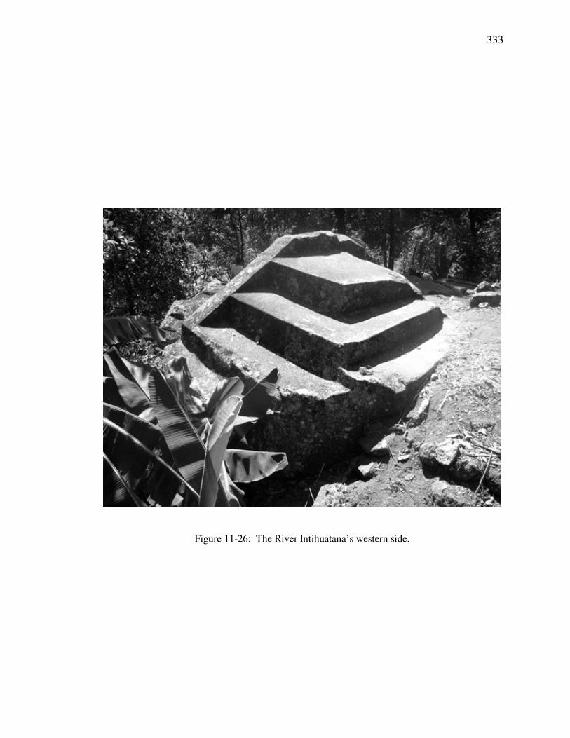
Figure 11-26: The River Intihuatana’s western side.
334
Figure 11-27: A magnified view of the locations of Machu Picchu’s Intihuatana
and Sacred Plaza as seen from the River Intihuatana.
335
11.3.2 Platform
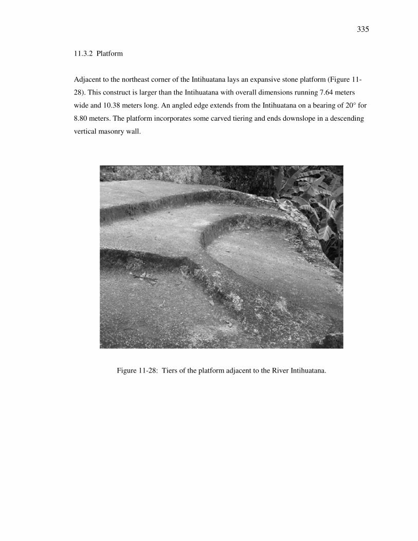
Adjacent to the northeast corner of the Intihuatana lays an expansive stone platform (Figure 11-
28). This construct is larger than the Intihuatana with overall dimensions running 7.64 meters
wide and 10.38 meters long. An angled edge extends from the Intihuatana on a bearing of 20° for
8.80 meters. The platform incorporates some carved tiering and ends downslope in a descending
vertical masonry wall.
Figure 11-28: Tiers of the platform adjacent to the River Intihuatana.
336
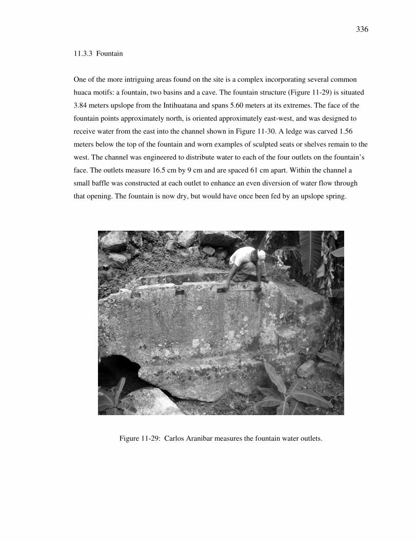
11.3.3 Fountain
One of the more intriguing areas found on the site is a complex incorporating several common
huaca motifs: a fountain, two basins and a cave. The fountain structure (Figure 11-29) is situated
3.84 meters upslope from the Intihuatana and spans 5.60 meters at its extremes. The face of the
fountain points approximately north, is oriented approximately east-west, and was designed to
receive water from the east into the channel shown in Figure 11-30. A ledge was carved 1.56
meters below the top of the fountain and worn examples of sculpted seats or shelves remain to the
west. The channel was engineered to distribute water to each of the four outlets on the fountain’s
face. The outlets measure 16.5 cm by 9 cm and are spaced 61 cm apart. Within the channel a
small baffle was constructed at each outlet to enhance an even diversion of water flow through
that opening. The fountain is now dry, but would have once been fed by an upslope spring.
Figure 11-29: Carlos Aranibar measures the fountain water outlets.
337
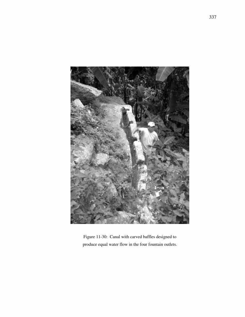
Figure 11-30: Canal with carved baffles designed to
produce equal water flow in the four fountain outlets.
338
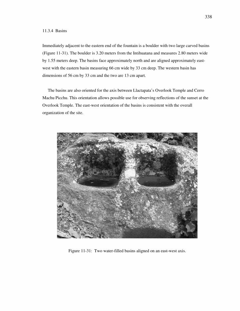
11.3.4 Basins
Immediately adjacent to the eastern end of the fountain is a boulder with two large carved basins
(Figure 11-31). The boulder is 3.20 meters from the Intihuatana and measures 2.80 meters wide
by 1.55 meters deep. The basins face approximately north and are aligned approximately east-
west with the eastern basin measuring 66 cm wide by 33 cm deep. The western basin has
dimensions of 56 cm by 33 cm and the two are 13 cm apart.
The basins are also oriented for the axis between Llactapata’s Overlook Temple and Cerro
Machu Picchu. This orientation allows possible use for observing reflections of the sunset at the
Overlook Temple. The east-west orientation of the basins is consistent with the overall
organization of the site.
Figure 11-31: Two water-filled basins aligned on an east-west axis.
339
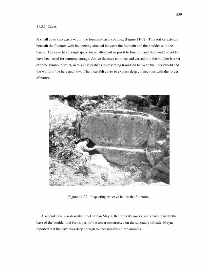
11.3.5 Caves
A small cave also exists within the fountain-basin complex (Figure 11-32). This orifice extends
beneath the fountain with its opening situated between the fountain and the boulder with the
basins. The cave has enough space for an attendant or priest to function and also could possibly
have been used for mummy storage. Above the cave entrance and carved into the boulder is a set
of three symbolic stairs, in this case perhaps representing transition between the underworld and
the world of the here and now. The Incas felt caves to express deep connections with the forces
of nature.
Figure 11-32: Inspecting the cave below the fountains.
A second cave was described by Esteban Mayta, the property owner, and exists beneath the
base of the boulder that forms part of the tower constructed on the sanctuary hillside. Mayta
reported that the cave was deep enough to occasionally entrap animals.
340
11.3.6 Structure A
Structure A has rectangular stone walls and lies to the east of the Intihuatana, 4.72 meters from
Platform P. This appears to have been a building able to serve as housing for the huaca’s priests
or other caretakers. The length of the structure is 6.40 meters and its width is 4.45 meters. Its
western wall contains a door 1.04 meters wide. The long walls are oriented approximately
100/280°, with the side walls about 010/190°.
11.3.7 Structure B
Structure B is situated 3.58 meters east of Structure A and is more nearly square in shape with
sides 3.83 meters long and 3.81 meters wide. A 97 cm door is situated at the center of the north
wall and the structure is oriented approximately 050/230° and 130/310°. This building might have
been used as a storehouse.
11.3.8 Boulder
Immediately upslope of Structure A and Structure B is a very large, unimproved boulder. It is
curious that this rock was left uncarved.
341
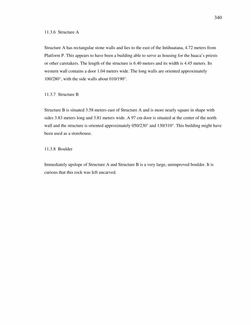
11.3.9 Steps
At a distance of 14.9 meters northeast of Structure B lies a small set of isolated stairs embedded
in the ground (Figure 11-33). Their positioning is of little practical use and they also exhibit the
three traditional steps of Inca cosmology.
Figure 11-33: Three symbolic steps on the huaca sanctuary grounds.
342
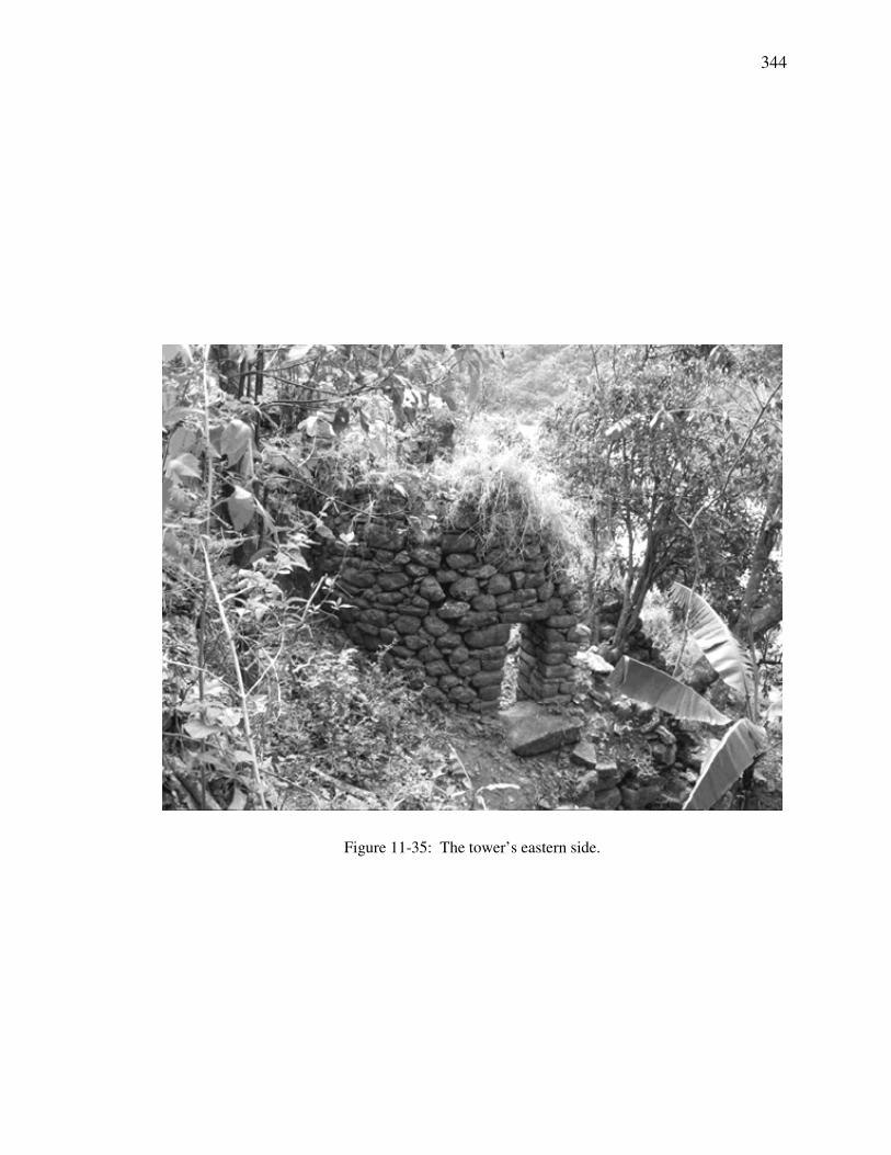
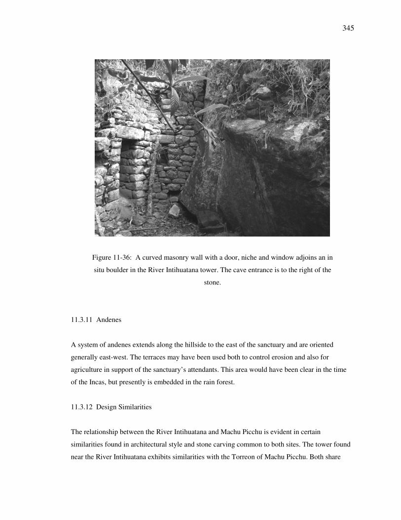
11.3.10 Tower
Further downslope and built into the side of the hill is a round tower (Figures 11-34 through 11-
36). The stones of an eastern circular wall adjoin a large in situ boulder that was used for the
tower’s southwestern side. The northern face is presently open. The eastern wall contains a door
(Figure 11-35) oriented to 086.7° true azimuth and the door is 2.10 meters opposite the in situ
boulder. The sun will rise on the horizon at 085.8°. The doorway is 1.28 meters high, 60 cm wide
at the lintel, and 74 cm wide at its base. Approximately equidistant between the door and the rock
is an internal niche with an upper lintel at the same height as that of the door. The niche is 56 cm
high, 29 cm wide at the lintel, and 34 cm wide at its base. A trapezoidal upper window is situated
78 cm above the niche and slightly offset toward the door. The window is 55 cm high, its upper
surface measures 28 cm and its base measures 40 cm. The window is oriented to 121.7°.
Calculated azimuth of equinox sunrise from the tower
Measured azimuth from the axis of the tower door to the horizon
Measured Azimuth: 090.0°
Magnetic Declination: 3.3° W
True Azimuth: 086.7°
Calculated ESR Azimuth: 085.8°
∆ Calc ESR Az & True Az: 0.9°
Measured Inclination: +19.0°
A stone wall holds back the earth outside of the doorway’s entrance on the east side of the
tower and continues downslope for 8 meters. Another stone wall retains the soil on the downslope
of the north side. On the tower’s west side a stone staircase with five steps descends the slope on
a north bearing toward the railroad. The top of the tower is open. A circular tower reaching to the
sky while sitting atop a cave may have served to symbolize and facilitate strong connections
between this world and those of the heavens and of the underworld.
Zuidema (1981b: 340-341) describes the sunturhuasi in the Hanan Haucaypata plaza in Cusco
as being a circular building with windows, a high roof, and a mast on top. He identifies it as a site
for visual observations of the sun and a marker of the zenith sun with similar use and stature as
the Coricancha or the Muyucmarca tower of Sacsahuaman. He mentions them all as belonging to
343
the same category of “temple of the sun.” The utility of the River Intihuatana’s circular tower
might also have been effective for zenith solar observations.
Figure 11-34: Looking down into the tower from above. The doorway is to the left
of center. The entrance to the cave is immediately below and adjacent to the free
stone.
344
Figure 11-35: The tower’s eastern side.
345
Figure 11-36: A curved masonry wall with a door, niche and window adjoins an in
situ boulder in the River Intihuatana tower. The cave entrance is to the right of the
stone.
11.3.11 Andenes
A system of andenes extends along the hillside to the east of the sanctuary and are oriented
generally east-west. The terraces may have been used both to control erosion and also for
agriculture in support of the sanctuary’s attendants. This area would have been clear in the time
of the Incas, but presently is embedded in the rain forest.
11.3.12 Design Similarities
The relationship between the River Intihuatana and Machu Picchu is evident in certain
similarities found in architectural style and stone carving common to both sites. The tower found
near the River Intihuatana exhibits similarities with the Torreon of Machu Picchu. Both share
346
plans that incorporate walls of curved masonry that include straight and open sections. The
masonry of each adjoins in situ rock used to form the remainder of the structure and both exhibit
caves at their bases. They each employ windows and niches and both exhibit solar orientations,
the Torreon for June solstice sunrise and the River Intihuatana tower for sunrise at equinox (see
Figures 11-12 and 11-36).
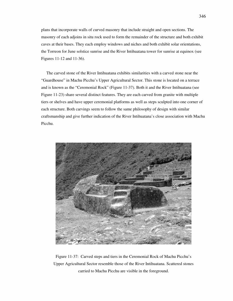
The carved stone of the River Intihuatana exhibits similarities with a carved stone near the
“Guardhouse” in Machu Picchu’s Upper Agricultural Sector. This stone is located on a terrace
and is known as the “Ceremonial Rock” (Figure 11-37). Both it and the River Intihuatana (see
Figure 11-23) share several distinct features. They are each carved from granite with multiple
tiers or shelves and have upper ceremonial platforms as well as steps sculpted into one corner of
each structure. Both carvings seem to follow the same philosophy of design with similar
craftsmanship and give further indication of the River Intihuatana’s close association with Machu
Picchu.
Figure 11-37: Carved steps and tiers in the Ceremonial Rock of Machu Picchu’s
Upper Agricultural Sector resemble those of the River Intihuatana. Scattered stones
carried to Machu Picchu are visible in the foreground.
347
Numbers of small-elongated stones, many about 30 cm by 15 cm in size, are seemingly
arranged in upright groups around the Ceremonial Rock. The stones are andesite, limestone, and
metamorphic rocks carried in from other regions. Some are river-rounded shaped rocks. Ruth
Wright and Alfredo Valencia suggest that “river rocks symbolically bring the sacred river to the
mountain site” (Wright and Valencia, 2001: 8). This may have been the case but the diversity of
rocks more likely indicates that they were ritual offerings/burdens carried and placed by visitors
at a shrine requiring this activity upon arrival at Machu Picchu. Modern Quechua travelers carry
small stones to the top of mountain passes to leave as offerings to the Apus, in this case perhaps
to Huayna Picchu. The Ceremonial Rock is the only huaca placed outside the walls of the main
section of Machu Picchu. In a manner similar to the social differentiation that occurred at the
Sanctuary of Isla del Sol (Bauer and Stanish, 2001), these offerings may have been carried to and
placed there by pilgrims who were not allowed to pass through the main gate of Machu Picchu.
Potsherds of chicha vessels have also been found in this area (Wright and Valencia, 2001).
The carved Ceremonial Rock, River Intihuatana (see Figure 11-23), Machu Picchu’s
Intihuatana (see Figure 11-5) and the Rumihuasi Stone at Saihuite (see Figure 9-66) have similar
sizes and are carved on all sides. The Intihuatana at Pisac is of an appropriate size, but is carved
on top and enclosed by masonry walls (see Figure 10-20). The Intihuatana of Tipon (see Figure 9-
53) is an exception in that it consists of several unimproved boulders atop a rock platform
overlooking the site’s terraces and horizon. The similarities in the carvings of Machu Picchu’s
Intihuatana, the River Intihuatana, the Ceremonial Rock, and the Rumihuasi Stone, such as
multiple sets of steps with different scales, suggests that these huacas shared common symbolic
meaning and function.
11.3.13 Access
Access to the River Intihuatana may have been by a trail leading down from the double-jambed
doorway of Machu Picchu’s Temple of the Moon. That route would have required a bridge to
cross the Urubamba River from the Inca trail on the north side of the river. A trail leading
downward from the southwestern terraces of Machu Picchu leads directly to the Intihuatana,
without a need to cross the river. The trail from the River Intihuatana to Llactapata may be similar
348
to the modern one: proceeding downstream to the confluence with the Aobamba and then up that
river for a short distance before turning and ascending the Llactapata Ridge.
11.4 Llactapata
Llactapata is located at S13°-11.12’; W072°-35.08’ and 2740 masl.
Motifs and Features: Llactapata is a multi-faceted complex that was found to
exhibit light and shadow effects, a solstitial orientation, a Pleiades orientation,
niches, double-jambed doorways, a channel, and structures.
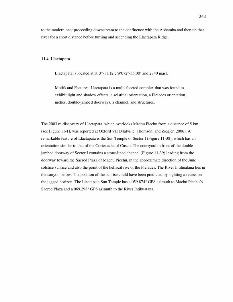
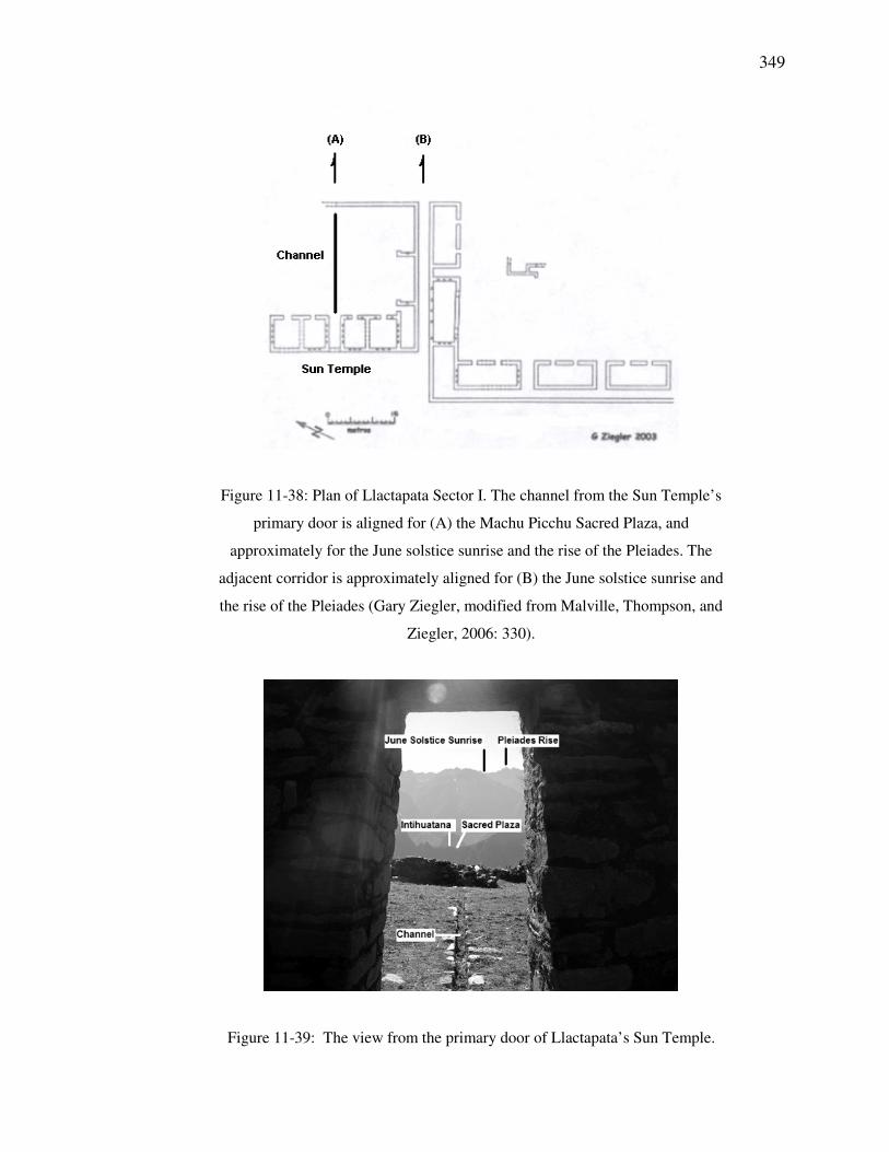
The 2003 re-discovery of Llactapata, which overlooks Machu Picchu from a distance of 5 km
(see Figure 11-1), was reported at Oxford VII (Malville, Thomson, and Ziegler, 2006). A
remarkable feature of Llactapata is the Sun Temple of Sector I (Figure 11-38), which has an
orientation similar to that of the Coricancha of Cusco. The courtyard in front of the double-
jambed doorway of Sector I contains a stone-lined channel (Figure 11-39) leading from the
doorway toward the Sacred Plaza of Machu Picchu, in the approximate direction of the June
solstice sunrise and also the point of the heliacal rise of the Pleiades. The River Intihuatana lies in
the canyon below. The position of the sunrise could have been predicted by sighting a recess on
the jagged horizon. The Llactapata Sun Temple has a 059.874° GPS azimuth to Machu Picchu’s
Sacred Plaza and a 069.298° GPS azimuth to the River Intihuatana.
349
Figure 11-38: Plan of Llactapata Sector I. The channel from the Sun Temple’s
primary door is aligned for (A) the Machu Picchu Sacred Plaza, and
approximately for the June solstice sunrise and the rise of the Pleiades. The
adjacent corridor is approximately aligned for (B) the June solstice sunrise and
the rise of the Pleiades (Gary Ziegler, modified from Malville, Thompson, and
Ziegler, 2006: 330).
Figure 11-39: The view from the primary door of Llactapata’s Sun Temple.
350
Llactapata was likely an integral part of the cosmological orientations of Machu Picchu. A
photo taken from Machu Picchu’s Intihuatana (see Figure 11-5) points to the location of
Llactapata’s Sun Temple on a ridge which is surrounded by some 100 other structures, still
engulfed by the cloud forest.
11.4.1 June Solstice Sunrise
The rugged Andean peaks surrounding Machu Picchu and Llactapata provide ample reference for
marking solar horizon events, thus natural features may have been used to identify sunrises or
sunsets from either location. On 18 June 2007 I documented the Llactapata sunrise over Machu
Picchu and its close alignment with the water channel extending from the Sun Temple (Fig. 11-
40). A similar sunrise orientation was observed from an adjacent 33 meter corridor, which
additionally aligns for the heliacal rise of the Pleiades. Rooms of the Coricancha of Cusco were
constructed so as to frame the rise of the Pleiades (Zuidema, 1982a: 212-214) (see Figure 8-1). In
a similar fashion the corridor adjacent to the Llactapata Sun Temple appears to have been
constructed to frame this event (Figure 11-38).
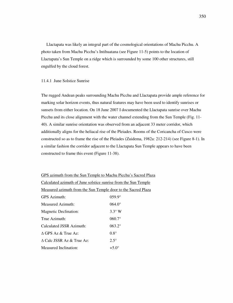
GPS azimuth from the Sun Temple to Machu Picchu’s Sacred Plaza
Calculated azimuth of June solstice sunrise from the Sun Temple
Measured azimuth from the Sun Temple door to the Sacred Plaza
GPS Azimuth: 059.9°
Measured Azimuth: 064.0°
Magnetic Declination: 3.3° W
True Azimuth: 060.7°
Calculated JSSR Azimuth: 063.2°
∆ GPS Az & True Az: 0.8°
∆ Calc JSSR Az & True Az: 2.5°
Measured Inclination: +5.0°
351
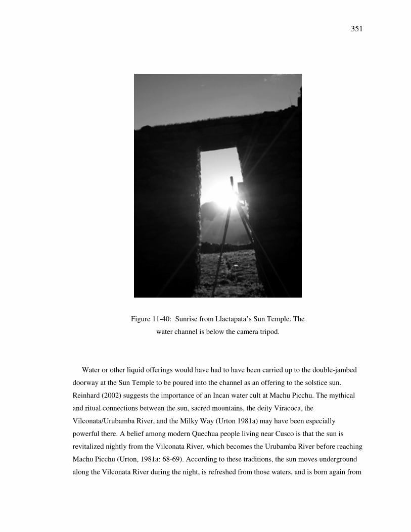
Figure 11-40: Sunrise from Llactapata’s Sun Temple. The
water channel is below the camera tripod.
Water or other liquid offerings would have had to have been carried up to the double-jambed
doorway at the Sun Temple to be poured into the channel as an offering to the solstice sun.
Reinhard (2002) suggests the importance of an Incan water cult at Machu Picchu. The mythical
and ritual connections between the sun, sacred mountains, the deity Viracoca, the
Vilconata/Urubamba River, and the Milky Way (Urton 1981a) may have been especially
powerful there. A belief among modern Quechua people living near Cusco is that the sun is
revitalized nightly from the Vilconata River, which becomes the Urubamba River before reaching
Machu Picchu (Urton, 1981a: 68-69). According to these traditions, the sun moves underground
along the Vilconata River during the night, is refreshed from those waters, and is born again from
352
the river. At the time of the June solstice the river is low and does not have sufficient water to
fully refresh the sun, hence its relative dimness. The pouring of water into the Llactapata channel
may have symbolically represented the feeding of the sun during the dry season.
11.4.2 Pleiades Rise
A 33 meter-long corridor lies east of and adjacent to Llactapata’s Sun Temple. Similarly, the
corridor is orientated toward both the June solstice sunrise and the nearby point of the heliacal
rise of the Pleiades. The corridor, which is 33 meters long and 2.5 meters wide, is oriented on an
azimuth of 063.5o. When viewed from the corridor’s rear, a field of view is created extending 4.3
o
along the horizon. In A.D. 1500, the June solstice sun rose at an azimuth of 064.3o while the
heliacal rise of the Pleiades ranged from 064.9o to 065.6
o (Malville, Thomson, and Ziegler, 2006:
333).
The Pleiades were of great importance in Inca astronomy as the Incas found them useful in
predicting and planning for harvests. The stars in this prominent grouping were viewed with
regard to their relative brilliance. Orlove, Chiang, and Cane (2000) argue that a bright appearance
by the Pleiades indicated a future of ample rain with a correspondingly good harvest.
Correspondingly, a dull appearance (caused by atmospheric obscuration) indicated that there
would be drought in the months to come. In actuality, a method had been discovered to anticipate
the future arrival of El Niño in a manner still used by Andean farmers today (Orlove, Chiang, and
Cane, 2000: 68).
11.4.3 Linked Ceremonialism between Llactapata and Machu Picchu.
Sun worship was the official religion of the Inca Empire and the royal family claimed descent
from the sun. Their legendary ancestor, Manco Capac, was said to have used a suit of gold and a
golden disk to reflect sunlight (Hemming, 1970: 52).
The account by Cristobal de Molina of a ceremony conducted by the Incas might provide
insight for similar ceremonies that would have been possible at the Llactapata Sun Temple at the
time of June solstice (Hemming, 1970: 172). The 33 meter corridor is of the appropriate size to
allow passage for a procession of pairs of people facing the rising sun. At the head of the column
the Inca wearing gold-plated attire could have generated a brilliant reflective image at sunrise.
353
The Coricancha means the “golden enclosure.” The sides of the temple facing sunrise were
covered with gold by at least 700 plates averaging 2 kgs each, amassing more than 1,400 kgs.
Additionally there was a band of gold with a width of 20 cm that ran along the entire building at
roof level (Hemming, 1970: 64; Hemming and Ranney, 1982: 78).
If the Llactapata Sun Temple was plated similarly to the Coricancha it would have been a
brilliant sight when reflecting the light of the dawn sun at the time of the June solstice. We have
no record of such plating, however. Llactapata is higher than Machu Picchu and it receives
illumination first on the morning of the solstice.
To demonstrate such a ceremony, I positioned a field assistant at the Sun Temple the day prior
with a 15 cm by 20 cm mirror. Sunrise occurred at Llactapata at 06:41 and on cue my assistant
captured the sun in the mirror and reflected its light toward me, now standing in Machu Picchu’s
Sacred Plaza. The reflections from 5 km across the canyon were prominent and continued
through the Sacred Plaza’s sunrise at 07:17 and beyond. The 36 minute period between the
Llactapata and Machu Picchu sunrises would have afforded ample time for a special ceremony
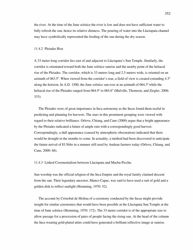
celebrating the morning solstice sun. A magnified view of the ridge (Fig. 11-41) clearly shows
the reflection from the Sun Temple. This demonstration exhibited the reflection from only a
hand-held mirror. Larger medallions worn by the emperor or plates mounted on the temple could
have produced a more brilliant effect.
354
Figure 11-41: Reflection of the June solstice sunrise at the center of the Llactapata
Sun Temple as seen from Machu Picchu’s Sacred Plaza.
11.5 Summary
The Incas encoded many examples of astronomical and cosmological significance at Machu
Picchu and the surrounding region. The Sacred Plaza and Torreon are aligned along a solar axis
extending from the horizon point of the June solstice sunrise to that of the December solstice
sunset. The Torreon has orientations for the June solstice sunrise and the heliacal rise of the
Pleiades. The Intihuatana is one of Machu Picchu’s most prominent features and can also be said
to look out over the December solstice sunset. The mortars may have been used for indirect
observations of the sun and moon or to reflect sunlight through a window on days of equinox.
The Intimachay was designed to observe sunrise at December solstice and the Temple of the
Condor has a potential sunrise alignment for days of the anti-zenith sun. The Building of Three
Windows near the top of Huayna Picchu is oriented to the December solstice sunset and features
of the Temple of the Moon on Huayna Picchu’s side align for sunset at June solstice.
355
The River Intihuatana lies at the junction of two solar axes, a northeast-southwest solstitial one
and another with an east-west orientation. The features of the River Intihuatana sanctuary are also
oriented predominantly east-west.
The River Intihuatana exhibits many motifs found in other Inca huacas with features such as
stairs, fountains, basins, and caves. Three examples of ritual stairs found within the River
Intihuatana sanctuary: standing alone on the grounds of the complex, situated above the cave
entrance between the basins and the fountain, and carved into the Intihuatana itself. None of these
were carved in a way that suggests any practical need and the steps above the cave are totally
non-functional.
The Incas designed fountains to be both practical and ceremonial and they may have served to
facilitate the life-force energizing effects of camay. Carved basins were used to hold gifts and
liquid sacrifices and might have been employed to observe reflections of the sun or moon.
The River Intihuatana’s circular tower reaching to the sky while sitting atop a cave may have
served to symbolize and facilitate strong connections between the world of the present and both
the gods of the heavens and the forces of the underworld. The tower is also a possible location for
observance of zenith passage of the sun.
Llactapata and its extensive array of structures suggest an even greater significance for the
Machu Picchu region, including a hypothesis that Pachacuti may have created a ceque system
here not unlike the one he instituted surrounding Cusco. A stone-lined channel in front of
Llactapata’s Sun Temple is aligned toward Machu Picchu’s Sacred Plaza and approximately for
the June solstice sunrise and the heliacal rise of the Pleiades. An adjacent corridor points to the
rise of the Pleiades and that of the June solstice sun. The Sun Temple, the River Intihuatana, and
the Sacred Plaza lie along a solar axis from the June solstice sunrise to the December solstice
sunset. Llactapata’s Overlook temple is approximately aligned across the River Intihuatana to
Cerro Machu Picchu on an east-west axis. The Emperor could possibly have conducted June
solstice sunrise ceremonies at Llactapata where he reflected the light of the rising sun to
onlookers at Machu Picchu’s Sacred Plaza, but there is no evidence to support this hypothesis.
356
Part V: Results
Chapter 12
Findings and Discussion
12.1 Introduction
I present evidence that the Incas practiced horizon astronomy in the Peruvian Andes through
positional observations of the rising and setting sun on days of ceremonial significance. The
majority of the sites examined in the areas of this study were found to involve attention to the
solstices.
The Urubamba pillars and the palace of Huayna Capac lie on a sightline to the June solstice
sunrise. The Sacred Plaza of Machu Picchu, the River Intihuatana, and the Llactapata Sun Temple
lie approximately along a line established by the June solstice sunrise and December solstice
sunset. The River Intihuatana is a classic huaca containing caves, fountains, steps and platforms.
The Temple of the Moon at Machu Picchu exhibits approximate orientations for the June solstice
sunset. The shrine at Choquequilla contains some of the finest carvings extant on any huaca and
aligns for the December solstice sunrise. Chinchero adds cardinal with solstitial orientations. The
carved rock huaca at Kenko Grande is rich with astronomical orientation and its neighbor at
Lacco features even more. The huaca with two circles exhibiting orientations for solar horizon
events may have been used in part to determine the positions of related sunrises and sunsets.
12.2 Findings
During the course of this study I searched for evidence of astronomical orientation in the features
found at 29 sites surrounding Cusco, in the Sacred Valley, and in and surrounding Machu Picchu.
357
The sites selected primarily were based on Bauer (1998), Hemming and Ranney (1982),
Gasparini and Margolies (1980), and suggestions from Dr. Kim Malville. Twenty-three of these
sites were either carved rock huacas or sanctuaries that included carved or otherwise significant
rocks. The remaining six sites were huacas or sanctuaries with structures, but lacking in intrinsic
rock shrines. These rock and non-rock huacas were categorized further as to whether or not they
exhibited any potential astronomical orientation. My research in the Region Surrounding Cusco
included huacas at 19 locations, seven of the sites were in the region of the Sacred Valley, and the
remaining three sanctuaries were related to Machu Picchu.
12.2.1 First Hypothesis
The majority of the currently identified rock huacas in the Cusco Valley, the
Sacred Valley, and surrounding Machu Picchu are associated with visual solar
phenomena.
Huacas were first divided into two groups – those that were or included rock shrines and those
that didn’t (Tables 12-1, 12-2, and 12-3). For the purposes of this study a huaca was considered
astronomical if it, or an element of it, was found to have a solar light and shadow effect or
potential orientations related in any way to the sun. If an orientation was found to exist and was
available for potential use it was included. This was the case with certain east-west alignments
that might have been used at the time of the equinoxes, even though it yet has to be proven that
the Incas were concerned with horizon positions of the sun on those days. At the same time it
hasn’t been proven that they did not use any of these east-west orientations when the sun rose and
set accordingly. Of the 29 shrines examined in this study 23, or 77%, were found to fit at least
one of the above criteria. Sixteen of the sites included ceremonial rocks with celestial orientations
and eight more had structures oriented with an aspect of the solar horizon. This equates to 55%
and 28% respectively. The 16 sites that include rocks with orientations are categorized as
“Astronomical Rock.” Sites such as Sacsahuaman and the River Intihuatana have ceremonial
rocks, but those rocks were not found to exhibit examples of astronomy. The sites did possess
other astronomical orientations, however, and were included with those displaying structural
celestial orientations in the “Astronomical Non-Rock” category. Five sites with boulders
displayed no evidence of solar orientations and one of the sites without a rock had none. The non-
celestial huacas comprised 21% of the sites of the study. Four of the “Non-Astronomical Rock”
huacas (without observable astronomical orientations) were Mesa Redonda, Tetecaca, Patallacta,
358
and Sapantiana, each among the closest to Cusco. They likely served purposes independent of the
sun. The fifth was Cerro Unoraqui which was part of a sightline from Quespiwanka, but exhibited
no additional orientations of its own. The other site without specific celestial orientation (“Non-
Astronomical Non-Rock”) was the ridgeline of Cerro Pumahuachana. It includes two sections of
wall ruins and a chapel on a crag, but displayed no distinct solar orientation. The ridge does,
however, lie under the same sightline between Quespiwanka and Cerro Unoraqui. The existence
of astronomical orientations at 79% of the sites studied supports this hypothesis and indicates that
many Inca huacas may well have been associated with solar observation and ceremony. If the
equinoxes are discounted then Lanlakuyok moves to the non-astronomical rock category and
Puca Pucara becomes non-astronomical non-rock, thus lowering this to 72%. Percentage
summaries are given in Tables 12-16 through 12-19.
Table 12-1: Huaca Classifications for the Region Surrounding Cusco.
359
Table 12-2: Huaca Classifications for the Sacred Valley Region.
Table 12-3: Huaca Classifications for the Machu Picchu Region.
12.2.2 Second Hypothesis
Those huacas found to be associated with visual solar phenomena (solar huacas)
exhibit orientations related to the solstices, equinoxes, zenith suns and anti-zenith
suns.
Eighty-three percent (19) of the solar huacas were found to exhibit orientations for the solstices
and 38% (9) displayed specific effects of light and shadow (Figures 12-13, 12-14, and 12-15).
Twenty-nine percent (7) had east and/or west orientations that potentially included the equinoxes
and 21% (5) had zenith or anti-zenith orientations (Tables 12-4, 12-5 and 12-6).
360
Sixty-three percent (10) of the 16 astronomical rock huacas had orientations for the June
solstice sunrise, 38% (6) for the June solstice sunset, 56% (9) for the December solstice sunrise
and 25% (4) for the December solstice sunset. Thirty-one percent (5) had east orientations with
possible utility at an equinox sunrise and 19% (3) had west orientations with similar potential for
the equinox sunset. There were three instances of zenith sun orientations (19%) and one (6%)
anti-zenith orientation.
The number of examples for June and December solstice is fairly even, somewhat unexpected
since the solstice in December is in the rainy season when observations of the horizon on specific
days would be expected to be far less reliable. There is a marked difference between the numbers
of orientations for solstice sunrises in both seasons when compared to those for the associated
sunsets. Results would imply a much greater ceremonial interest in the rising sun.
Two of the seven astronomical non-rock huacas had June solstice sunrise orientations (29%),
none for the June solstice sunset, three for the December solstice sunrise (43%) and none for the
December solstice sunset.
Of the 23 huacas with any astronomical association 96% held at least one orientation for one
of the six primary solar horizon events of sunrise and sunset at June solstice, December solstice
and the equinoxes. If the equinoxes are removed then this figure becomes 83%. There were a total
of five possible examples of zenith sun alignments (22%) and two instances of potential
alignments related to the anti-zenith sun (9%). While there were fewer examples regarding the
zenith sun and anti-zenith sun found with these rural huacas, the zenith-related events were a
significant interest within the city of Cusco. June solstice sunrise orientations were noted 19 times
in all (including multiple orientations at the same site), June solstice sunset 7 times, December
solstice sunrise 12 times, December solstice sunset 8 times, east/equinox sunrise 10 times and
west/equinox sunset 9 times.
While major sites such as Kenko Grande, Saihuite, Chinchero and Machu Picchu were found
to have multiple solar horizon orientations, many of the rest exhibited only one or two.
Thus the 2nd
hypothesis was supported in part as 96% of solar huacas appear to have
incorporated direct observation of horizon events when both solstices and equinoxes are included,
and 83% when the equinoxes are not.
361
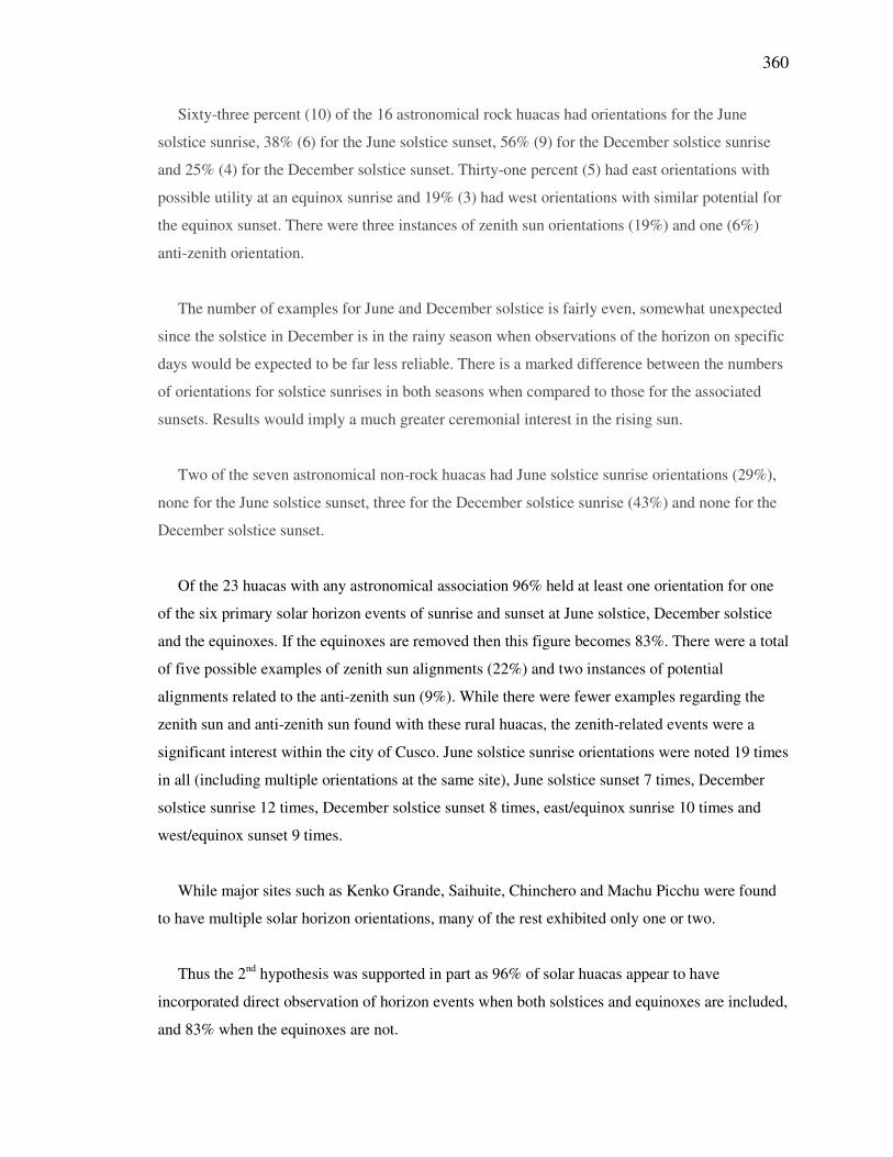
Table 12-4: Huaca Astronomical Orientations in the Region Surrounding Cusco.
Legend:
JSSR–June Solstice Sunrise DSSR–December Solstice Sunrise ESR–Equinox Sunrise
JSSS–June Solstice Sunset DSSS–December Solstice Sunset ESS–Equinox Sunset
362
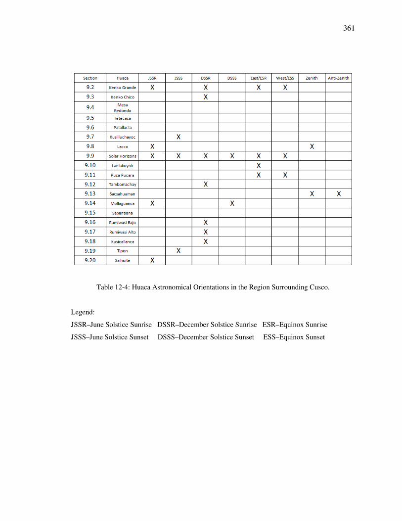
Table 12-5: Huaca Astronomical Orientations in the Sacred Valley Region.
Table 12-6: Huaca Astronomical Orientations in the Machu Picchu Region.
12.2.3 Third Hypothesis
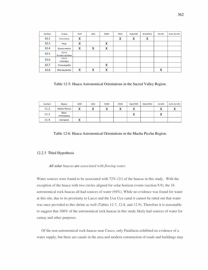
All solar huacas are associated with flowing water.
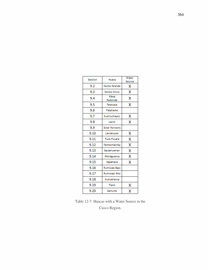
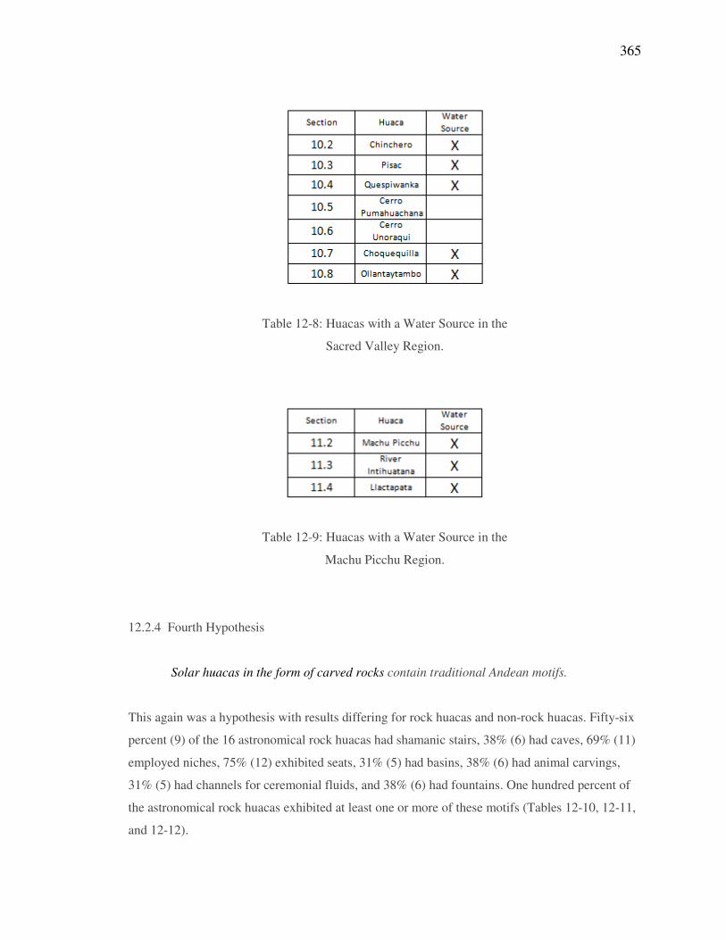
Water sources were found to be associated with 72% (21) of the huacas in this study. With the
exception of the huaca with two circles aligned for solar horizon events (section 9.9), the 16
astronomical rock huacas all had sources of water (94%). While no evidence was found for water
at this site, due to its proximity to Lacco and the Ucu Ucu canal it cannot be ruled out that water
was once provided to this shrine as well (Tables 12-7, 12-8, and 12-9). Therefore it is reasonable
to suggest that 100% of the astronomical rock huacas in this study likely had sources of water for
camay and other purposes.
Of the non-astronomical rock huacas near Cusco, only Patallacta exhibited no evidence of a
water supply, but there are canals in the area and modern construction of roads and buildings may
363
mask the path of ancient hydraulics. Immediate sources of water were not identified at the
astronomical non-rock sites of Rumiwasi Bajo, Rumiwasi Alto and Kusicallanca. The peak of
Cerro Unoraqui was understandably without a water source, as was the Sun Temple on the
Llactapata ridge. Water would have had to have been carried to the channel that leads from the
temple toward Machu Picchu and the June solstice sunrise.
One-hundred percent (16) of the solar rock huacas were found to have or were likely to have
had sources of flowing water. Only 38% (3) of the eight astronomical non-rock sites of this study
were found to have water sources, either present or past. The 3rd
hypothesis was supported for
huacas made of rock, but not for other huacas. This finding is in keeping with forces of camay
being employed to bring life to these venerated stones.
364
Table 12-7: Huacas with a Water Source in the
Cusco Region.
365
Table 12-8: Huacas with a Water Source in the
Sacred Valley Region.
Table 12-9: Huacas with a Water Source in the
Machu Picchu Region.
12.2.4 Fourth Hypothesis
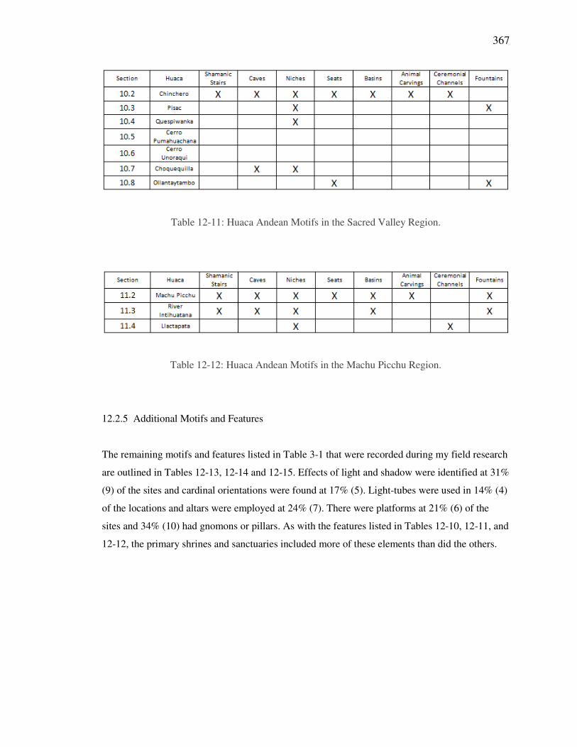
Solar huacas in the form of carved rocks contain traditional Andean motifs.
This again was a hypothesis with results differing for rock huacas and non-rock huacas. Fifty-six
percent (9) of the 16 astronomical rock huacas had shamanic stairs, 38% (6) had caves, 69% (11)
employed niches, 75% (12) exhibited seats, 31% (5) had basins, 38% (6) had animal carvings,
31% (5) had channels for ceremonial fluids, and 38% (6) had fountains. One hundred percent of
the astronomical rock huacas exhibited at least one or more of these motifs (Tables 12-10, 12-11,
and 12-12).
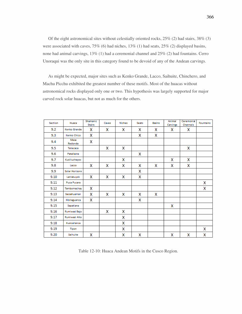
366
Of the eight astronomical sites without celestially oriented rocks, 25% (2) had stairs, 38% (3)
were associated with caves, 75% (6) had niches, 13% (1) had seats, 25% (2) displayed basins,
none had animal carvings, 13% (1) had a ceremonial channel and 25% (2) had fountains. Cerro
Unoraqui was the only site in this category found to be devoid of any of the Andean carvings.
As might be expected, major sites such as Kenko Grande, Lacco, Saihuite, Chinchero, and
Machu Picchu exhibited the greatest number of these motifs. Most of the huacas without
astronomical rocks displayed only one or two. This hypothesis was largely supported for major
carved rock solar huacas, but not as much for the others.
Table 12-10: Huaca Andean Motifs in the Cusco Region.
367
Table 12-11: Huaca Andean Motifs in the Sacred Valley Region.
Table 12-12: Huaca Andean Motifs in the Machu Picchu Region.
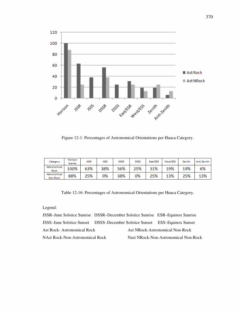
12.2.5 Additional Motifs and Features
The remaining motifs and features listed in Table 3-1 that were recorded during my field research
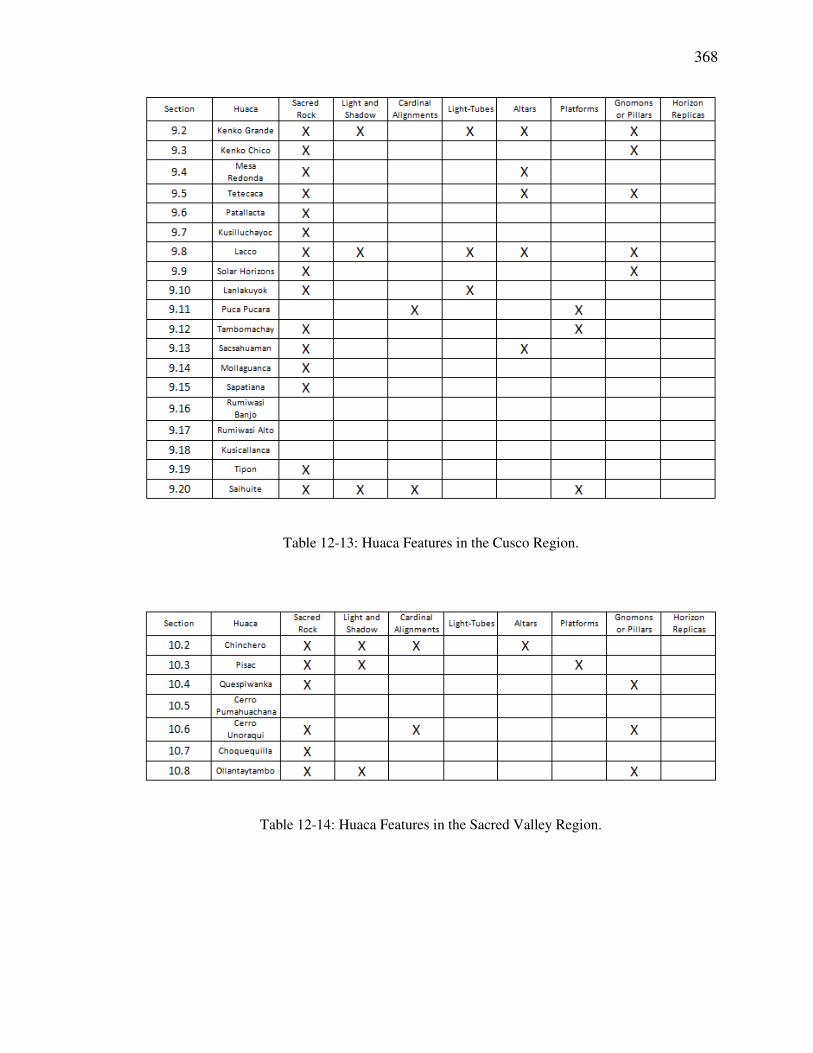
are outlined in Tables 12-13, 12-14 and 12-15. Effects of light and shadow were identified at 31%
(9) of the sites and cardinal orientations were found at 17% (5). Light-tubes were used in 14% (4)
of the locations and altars were employed at 24% (7). There were platforms at 21% (6) of the
sites and 34% (10) had gnomons or pillars. As with the features listed in Tables 12-10, 12-11, and
12-12, the primary shrines and sanctuaries included more of these elements than did the others.
368
Table 12-13: Huaca Features in the Cusco Region.
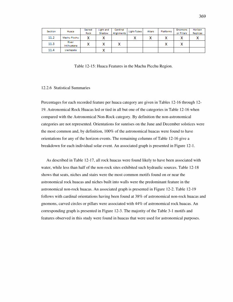
Table 12-14: Huaca Features in the Sacred Valley Region.
369
Table 12-15: Huaca Features in the Machu Picchu Region.
12.2.6 Statistical Summaries
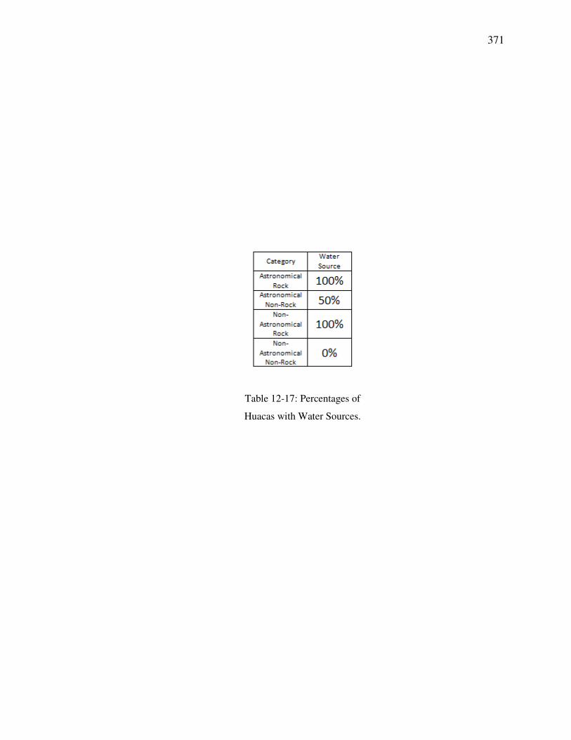
Percentages for each recorded feature per huaca category are given in Tables 12-16 through 12-
19. Astronomical Rock Huacas led or tied in all but one of the categories in Table 12-16 when
compared with the Astronomical Non-Rock category. By definition the non-astronomical
categories are not represented. Orientations for sunrises on the June and December solstices were
the most common and, by definition, 100% of the astronomical huacas were found to have
orientations for any of the horizon events. The remaining columns of Table 12-16 give a
breakdown for each individual solar event. An associated graph is presented in Figure 12-1.
As described in Table 12-17, all rock huacas were found likely to have been associated with
water, while less than half of the non-rock sites exhibited such hydraulic sources. Table 12-18
shows that seats, niches and stairs were the most common motifs found on or near the
astronomical rock huacas and niches built into walls were the predominant feature in the
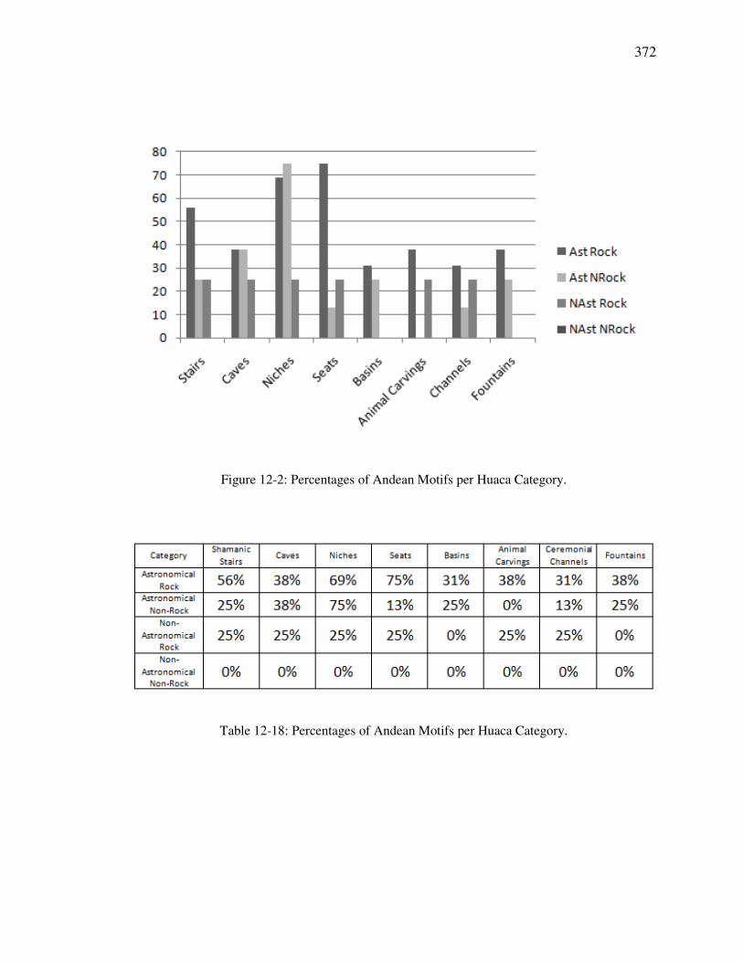
astronomical non-rock huacas. An associated graph is presented in Figure 12-2. Table 12-19
follows with cardinal orientations having been found at 38% of astronomical non-rock huacas and
gnomons, carved circles or pillars were associated with 44% of astronomical rock huacas. An
corresponding graph is presented in Figure 12-3. The majority of the Table 3-1 motifs and
features observed in this study were found in huacas that were used for astronomical purposes.
370
Figure 12-1: Percentages of Astronomical Orientations per Huaca Category.
Table 12-16: Percentages of Astronomical Orientations per Huaca Category.
Legend:
JSSR–June Solstice Sunrise DSSR–December Solstice Sunrise ESR–Equinox Sunrise
JSSS–June Solstice Sunset DSSS–December Solstice Sunset ESS–Equinox Sunset
Ast Rock- Astronomical Rock Ast NRock-Astronomical Non-Rock
NAst Rock-Non-Astronomical Rock Nast NRock-Non-Astronomical Non-Rock
371
Table 12-17: Percentages of
Huacas with Water Sources.
372
Figure 12-2: Percentages of Andean Motifs per Huaca Category.
Table 12-18: Percentages of Andean Motifs per Huaca Category.

373
Figure 12-3: Percentages of Features per Huaca Category.
Table 12-19: Percentages of Features per Huaca Category.
374
12.3 Discussion
12.3.1 Cusco Region
Examples such as the “Eyes of the Puma” at Kenko Grande demonstrate a considerable
knowledge of horizon astronomy and the degree of the creativity that the Incas were capable of in
the development of their shrines. On the top of the outcrop they carved two carved cylinders that
form the puma’s eyes and then created a fissure in the nearby wall that allows light to fall upon
those carved cylinders at the appropriate time during the June solstice sunrise in a manner that
completes the “puma” visual effect, as shown in Figure 9-4.
With its many carvings and motifs, Kenko Grande was truly a most important huaca. Near the
puma is the kenko, or zigzagged channel, from which the huaca appears to derive its name. Such
channels appear at several locations in the empire for supposed purposes of offerings and
divination. The most likely offering was chicha, or corn beer, which is still traditionally
homebrewed and available in rural villages at bars and restaurants. The drink was common in
Inca times and must have held significant spiritual value. “These women made large amounts of
high-quality chicha which was for offerings to the gods and for the priests to drink” (Cobo, 1990
[1653]: 174). Other fluids could be used as well. Certainly water with its sacred connotations was
incorporated into ritual, and blood, such as of the llama, may have been used at times of sacrifice.
Many channels incorporated multiple paths and the specific flow of the liquid was likely used for
divination.
The chamber within Kenko Grande exhibits traditional motifs of caves, niches and steps. The
primary altar is finely carved and may have served in one or more types of ceremonial functions.
The tube in the cave’s upper northwest corner admits light that could be reflected from plates in a
niche to illuminate the entire chamber. It also facilitates a special effect of light and shadow on
the ceremonial steps adjacent to the primary altar, as depicted in Figure 9-9. The huaca has an
east or west opening at respective ends of its cave, with the southeastern one oriented to to the
east that will receive the light of the equinox sunrise, and the one to the northwest to the west
admitting illumination from the equinox sunset. The secondary altar, situated near the southeast
entry, is illuminated at dawn during the time of the March and September equinox sunrises.
375
Lacco exhibits fine examples of the Incas’ passion for using light from the sun or moon in
their shrines and ceremonies. The huaca was finely carved across its top and still shows many
examples of Inca sculptures such as seats, steps and animals. It is the caves, however, that truly
demonstrate the prowess the Incas had for solar orientation. Each of the three has altars that the
Incas deemed important enough to illuminate at certain times by the sun or moon. The exact
ceremonies performed remain subject to interpretation, but the ability to utilize solar or lunar light
while conducting them is clear. The Northeast Cave’s altar is fully illuminated in the early
morning on days approaching, during, and following the June solstice. The alignment of the cave
opening’s center with the sunrise point on the horizon is striking, as was shown in Figure 9-21.
The sun’s rays are cast directly upon the altar and reflections brightly illuminate the rest of the
chamber. Two large steps are situated immediately in front of the cave and may have been a part
of associated ceremonies. In front of the steps are two large separate thrones that also are oriented
toward the solstice sunrise. The thrones would have been excellent locations for observing the
rising sun.
The Southeast and Southwest Caves incorporate specifically oriented light-tubes to admit the
rays of the sun or moon. The Southwest Cave is the smaller of the two and also has a smaller
altar. Its light-tube’s alignment with the region of the ecliptic was shown with the waxing
crescent moon in Figure 9-23 and light will be admitted when the sun or moon crosses the sky at
an angle of 70°-75° above the horizon. The Southeast Cave appears to have been the most
prominent of the three as evidenced by the degree of workmanship in its sculpture, complete with
fine carvings of a puma and snake near its entrance and the highly polished altar within its inner
chamber. The altar is of an appropriate size and height for ceremony and sacrifice and is
brilliantly illuminated by the sun when it approaches 90° above the horizon near the time of the
zenith, as was shown with Figure 9-26. The zenith orientation of this light-tube is important due
to the significance that zenith passage plays in the Inca calendar. There is a deep chamber
adjacent to the altar that gives the appearance of entry into the underworld, a cosmological
connection that is common with many Inca caves.
The huaca located between Kenko Grande and Lacco with the two circles that exhibit
orientations indicating horizon positions of the solstice and east-west/equinox solar events is
especially interesting. While this site is known to the locals, its function appears to have been
overlooked by previous scholarly investigation. It is intriguing to find a construct that includes
orientations for all primary solar horizon positions and I have drawn these orientations in Figure
376
9-30 and Figure 9-31. I first observed the east-west orientations of the circles and then noted the
additional orientations for the solstices. This site may as well have had other functions, but for
reasons yet to be determined watching solstice and eastern/equinox sunrises and sunsets appears
that it my have been important here. The many seats carved upon the huaca underscore this
relationship as there is at least one oriented for each of the associated sun risings or settings, with
the exception of the June solstice sunset where that part of the outcrop has eroded extensively.
The full extent of the Incas’ purpose for this huaca remains to be seen.
The separation of elites and non-elites for the viewing of special solar events is an interesting
concept that is also possible at Tipon and Quespiwanka. Bauer and Stanish (2001) suggested that
the Incas separated such viewings at the Island of the Sun in Lake Titicaca. I observed that both
Tipon and Quespiwanka also appear to be oriented for class division regarding solar ceremonies.
At Tipon there is a double-jambed door along the trail leading up the hill to the Intihuatana
complex. Inca rulers desiring to indoctrinate the masses appear to have created separate viewing
areas for them aside from those of the elite. In each case orientations were such that the non-elite
viewers would see the sun rise or set over the elites, perhaps even the ruling Inca himself. As the
son of the sun, this effect would certainly be a valuable part of the state-sponsored indoctrination
received by pilgrims. The same could have occurred at Quespiwanka where non-elites were
barred from the main palace grounds by a triple-jambed entranceway, but could view the June
solstice sun rise over the palace from outside its south wall.
12.3.2 Sacred Valley Region
Many structures at Chinchero were constructed with cardinal orientations and a question that
remains is by what means did the Incas determine them? It is possible to determine these
directions by shadow at the times of equinoxes. Otherwise a gnomon shadow plot could be used
to establish true south. No matter which method was used, the end result is impressive.
I found several orientations during my research that were cardinally east and west. A lingering
question concerns whether or not the Incas recognized the exact dates of the equinoxes on the
horizon. There is no record of such interest in the Spanish chronicles. What did the equinox mean
to the Incas? Their understanding of the event was likely quite different from ours.
377
Chinkana, Mesakaka, and Kondorkaka are all aligned north and south with regard to one
another. While it is unlikely that Chinkana was moved, the other two huacas are small enough to
have had their positions adjusted. Chinkana and Titikaka are aligned approximately on the axis of
the June solstice sunrise and December solstice sunset. Both rocks would seem to be immovable,
so how were the Incas fortunate enough to have these two major outcrops align with this most
important axis? Regardless, they used the orientation to their advantage with the orientation of the
triangular basin and the balcony on Chinkana, as well as the hole on the upper surface of
Titikaka. Paternosto (1996) talks much about Inca textiles and it would seem possible that they
may have hung a banner from a pole set into this post-hole. The banner, or flag, could then have
been a visual part of the orientation of the rocks for the June solstice sunrise or the December
solstice sunset. As viewed from Chinkana’s balcony, a large banner atop Titikaka could help
accentuate the ritual setting of the December solstice sun.
Pisac’s most distinguishing feature is its Intihuatana. The name and meaning of intihuatana is
a matter of debate and is now thought to be somewhat of a misnomer applied in more recent
times. Traditionally these may have been “hitching posts of the sun,” or the term simply may
have been given to them by local villagers in later years. The stones are normally the most
impressive of the sites they occupy, and the one at Pisac is no exception. It is a carved huaca with
a carved cylinder on top. Unlike other intihuatanas, though, this one is enclosed by masonry walls
in the shape of the letter “D.” At Tipon the intihuatana is different still as it has not been carved
and instead consists of several unimproved boulders that are gathered together on a prominent
point of the site. The intihuatanas at Machu Picchu and the Urubamba River are both finely
carved on all four sides. The Machu Picchu Intihuatana is located on high ground, while the River
Intihuatana is low in a river valley. The River Intihuatana also shares features in common with
stones such as the Ceremonial Rock of Machu Picchu and the Rumihuasi Stone of Saihuite.
Neither of these rocks are commonly known as intihuatanas, but they are quite similar to the one
by the Urubamba River. Perhaps there is no definitive answer as to whether some of these sites
actually constitute intihuatanas in the traditional sense, if some of those that are not should be, or
even what intihuatana really means.
The pillars above Quespiwanka are remarkable examples of a piece of Inca history. Spanish
chroniclers recorded solar pillars on the horizons of Cusco, but all were eradicated, presumably in
the Catholic purge of Inca idolatries. Their locations were recorded, but no remains have been
found. Accounts speak of them being used to monitor solar positions, but there is no extant
378
evidence to this effect. The pillars near Urubamba give credibility to the reports in Cusco and
enable us to study this form of horizon astronomy first-hand. The two towers survive very well on
the Cerro Sayhua ridge and show the feasibility of this method to mark the June solstice sunrise.
The alignment supports Bauer’s and Dearborn’s 1995 hypothesis with regard to these structures
as well as Niles’ (1999) suggestions regarding the prominence of the white granite boulder and
the adjacent platform that were the central features of Huayna Capac’s palace grounds. The utility
of the boulder and platform as the focal point of the plaza is supported by this orientation and, to
a lesser extent, by potential alignments with natural horizon features for the December solstice
sunrise and the June solstice sunset. The remains of a wall on top of Cerro Pumahuachana and the
three pillars at the peak of Cerro Unoraqui remain enigmatic and inspire many questions as to
their meaning and purpose.
12.3.3 Machu Picchu Region
Machu Picchu is rich with astronomical symbolism. The orientations exhibited for the major solar
axis of the June solstice sunrise/December solstice sunset are especially noteworthy. Within
Machu Picchu the Torreon, Royal Mausoleum and the Sacred Plaza each have orientations
associated with these horizon events and form one end of what could have been an intentional
ceque that included the River Intihuatana and Llactapata Sun Temple. This orientation is clearly
demonstrated when sunrise over Machu Picchu is viewed from Llactapata on the morning of the
June solstice. Polo de Ondegardo (1965 [1571]) tells us that each Inca village had ceques
connecting shrines and it appears possible that a ceque system may have been established at
Machu Picchu, smaller but similar to the one in Cusco. An additional ceque possibility in this
area is the alignment of Llactapata’s Overlook Temple with the River Intihuatana and Cerro
Machu Picchu. The possibility of ceques and huacas other than in Cusco is intriguing. Certain
Machu Picchu huaca locations and alignments lend themselves in support of this concept and
ultimately may validate Polo de Ondegardo’s claim.
The Intihuatana of Machu Picchu is perhaps the best known stone of the empire. It is finely
carved in its entirety and includes a vertical column in the center of its upper surface. The
meaning and purpose of the Intihuatana is subject to debate, but it appears to exhibit no apparent
functions regarding any astronomical orientations. It is similar to most of the other intihuatanas in
that it is sculpted on all four sides, but the specific carvings of Machu Picchu’s Ceremonial Rock
bear a much closer resemblance to those found on others such as the River Intihuatana. The
379
stones from the river that were brought to surround the Ceremonial Rock emphasize the potential
relationship between these two. The Rumihuasi Stone at Saihuite also is similar and taken
together these likenesses suggest common purpose for these three stones. If the River Intihuatana
was indeed an intihuatana, then were the Ceremonial Rock and the Rumihuasi Stone intihuatanas
as well? If not, then was the River Intihuatana, first named so by Bingham, really an intihuatana
at all? At the bottom of a river valley it certainly was not in a position as favorable to the sun as
were its counterparts. The intihuatanas at Machu Picchu, Pisac, Tipon and the Urubamba River
have been described as “hitching posts of the sun,” but perhaps their true functions were
somewhat different.
The River Intihuatana appears to have played a much more significant role in the overall
complex surrounding Machu Picchu than was previously known. It provides a distinct link
between the huacas and structures of Machu Picchu and Llactapata and may be part of a ceque
system connecting them both. In addition to lying on the June solstice sunrise/December solstice
sunset axis, the River Intihuatana also is part of an alignment between the points of an east-
west/equinox sunrise and sunset that includes Llactapata’s Overlook Temple and Cerro Machu
Picchu. This potential ceque emphasizes the possible significance of the River Intihuatana as it is
positioned at the junction of these two prominent axes. The locations of Llactapata’s Sun Temple
and Overlook Temple may have been selected specifically to form these alignments. The Sun
Temple is remarkable in its orientation with Machu Picchu near to the axis of June solstice
sunrise and December solstice sunset. The placement of the River Intihuatana between them was
likely deliberate. The rediscovery of Llactapata and all of its many structures has suggested that
an intricate system existed throughout the area that was both planned in location and linked in
function. The prominence of the River Intihuatana began to emerge as a result of these Llactapata
orientations. This appears to be a site selected for great significance.
The location of the River Intihuatana is noteworthy as it lies near the banks of the powerful
Urubamba River as well as at the junction of two prominent solar axes. Upstream the Urubamba
is known as the Vilcanota, the river central to the circulation of cosmological energy from the
earth, through the Milky Way, and then back again by way of sacred mountains. Great power was
thought by the Incas to emanate from these waters, thus the river’s southeast to northwest
orientation makes for a third celestial/cosmological associated orientation that intersects at the
site of the River Intihuatana, a correlation of which the Incas would have been well aware.
380
The features incorporated into this huaca also imply its importance to the Incas. The River
Intihuatana exhibits examples of many of the motifs found in other Inca shrines. Its stairs,
fountain, basins, and caves, along with the platform and tower, would all indicate that a great
effort was put into establishing this sanctuary and of the significance that it held.
The platform at the River Intihuatana is situated such that it has a clear view of both the
Llactapata Overlook Temple and the Machu Picchu Intihuatana. Platforms were often constructed
for spiritual use and frequently served as ceremonial locations for sacrifices. These platforms
were called usnu and Hemming and Ranney (1982: 37) tell us that the Spanish chronicler Cabello
de Balboa stated “[Huayna Capac] had erected in the square a structure called usnu or chinquin-
pillaca, where sacrifices might be offered to the sun and its different phases, with chichi [maize
beer] poured out in its honor.” The River Intihuatana’s platform is adjacent to the Intihuatana,
well situated to appease the sun with appropriate sacrifice.
The second cave on the sanctuary is located beneath the boulder forming the western side of a
tower with a rounded wall. The location of this tower at the bottom of a canyon is interesting. Its
utility in solar observations would be limited by high horizons, but it still could have been used to
note passage of the sun at zenith. A circular tower reaching to the sky while sitting atop a cave
may have served to symbolize and facilitate connections between the world of the present and
both the gods of the heavens and the forces of the underworld. The cave could have symbolically
provided access to the Pachamama and might also have served to preserve a mummy.
The symbology found at the River Intihuatana appears to have been significant, perhaps
diminishing the possibility that it was a simply a stop for pilgrims in the area. Instead the primary
function of the huaca seems more likely to have been as a ritual center for ceremonies that served
to connect with forces of the supernatural. The River Intihuatana may have been a key component
in the power and significance of the greater Machu Picchu complex.
The 2003 rediscovery of Llactapata has given rise to many new questions regarding the overall
extent, orientation, and function of the entire Machu Picchu ceremonial complex. Its many
structures suggest a significant enlargement of the overall estate and introduce the possibility that
there may have been a ceque system here as well as the one located in Cusco. The orientation of
the stone-lined channel and Sun Temple at Llactapata with the River Intihuatana and Machu
Picchu’s Sacred Plaza is striking and, as shown in Figures 11-33b and 11-34, can be clearly seen
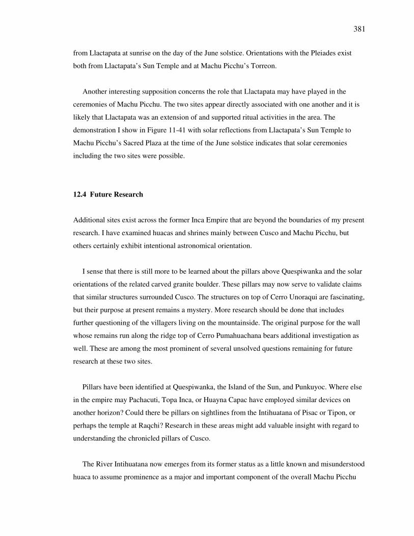
381
from Llactapata at sunrise on the day of the June solstice. Orientations with the Pleiades exist
both from Llactapata’s Sun Temple and at Machu Picchu’s Torreon.
Another interesting supposition concerns the role that Llactapata may have played in the
ceremonies of Machu Picchu. The two sites appear directly associated with one another and it is
likely that Llactapata was an extension of and supported ritual activities in the area. The
demonstration I show in Figure 11-41 with solar reflections from Llactapata’s Sun Temple to
Machu Picchu’s Sacred Plaza at the time of the June solstice indicates that solar ceremonies
including the two sites were possible.
12.4 Future Research
Additional sites exist across the former Inca Empire that are beyond the boundaries of my present
research. I have examined huacas and shrines mainly between Cusco and Machu Picchu, but
others certainly exhibit intentional astronomical orientation.
I sense that there is still more to be learned about the pillars above Quespiwanka and the solar
orientations of the related carved granite boulder. These pillars may now serve to validate claims
that similar structures surrounded Cusco. The structures on top of Cerro Unoraqui are fascinating,
but their purpose at present remains a mystery. More research should be done that includes
further questioning of the villagers living on the mountainside. The original purpose for the wall
whose remains run along the ridge top of Cerro Pumahuachana bears additional investigation as
well. These are among the most prominent of several unsolved questions remaining for future
research at these two sites.
Pillars have been identified at Quespiwanka, the Island of the Sun, and Punkuyoc. Where else
in the empire may Pachacuti, Topa Inca, or Huayna Capac have employed similar devices on
another horizon? Could there be pillars on sightlines from the Intihuatana of Pisac or Tipon, or
perhaps the temple at Raqchi? Research in these areas might add valuable insight with regard to
understanding the chronicled pillars of Cusco.
The River Intihuatana now emerges from its former status as a little known and misunderstood
huaca to assume prominence as a major and important component of the overall Machu Picchu
382
ceremonial complex. Additional research will help to further develop the context within which it
functioned.
The huaca between Kenko Grande and Lacco that has the two circles aligned for each of the
solstice and east-west/equinox horizon events is an area that I plan to examine further in an
attempt to understand the intended purpose for these orientations, as well as the other non-
astronomical functions for which the huaca was most likely used.
The concept of segregated elite/non-elite areas for viewing of key solar events may have
exhibited examples at Lake Titicaca, Quespiwanka and Tipon. Other known and potential
pilgrimage centers should be examined for the possibility that segregated viewing was conducted
there as well.
Establishing that ceques existed outside of Cusco warrants further study and present research
indicates that the huacas of Machu Picchu well may have been organized along such lines.
Additional investigation should help to either substantiate or refute this concept.
12.5 Concluding Remarks
At first glance solar huacas and non-astronomical shrines appear quite similar. Their features
exhibit little or nothing that would immediately indicate any astronomical orientation. Certain
huacas without celestial meaning are very finely carved, yet a significant rock with solar
orientations at Quespiwanka was not sculpted at all. Astronomical huacas do have more instances
of water sources, but others have channels as well.
The picture emerges of a culture interwoven with cosmology and astronomy. The Incas
possessed celestial knowledge and as solar worshippers they chose to incorporate and display
orientations and features of the sun, their god, in their many temples and shrines throughout the
empire. The huacas of this study point to a society that was both infatuated with the sun and that
possessed the technical ability to use their celestial knowledge with any structure or carving they
so desired.