Embed Size (px)
Citation preview

8/8/2019 Guidelines for the ion of Metropolitan Toronto
http://slidepdf.com/reader/full/guidelines-for-the-ion-of-metropolitan-toronto 1/70
,
•
•
" CD '
•
..

8/8/2019 Guidelines for the ion of Metropolitan Toronto
http://slidepdf.com/reader/full/guidelines-for-the-ion-of-metropolitan-toronto 2/70
ContentsIntroduction 3
An tic ip a te d Growth 3
UJ si'i of th e G ui d cllllc \ 3
Wh o u lI SC th e G ll idelin es? 4
Orga ni sation o f th<: C u id e lin es 4
Urban Structure and Tran.lt 5
The Guidel ine. 7
A Should the Area be Reurbanised? 7
B What Type of Reurbanisotion Area is it? 11
Ma j or Metro Ce nt res 13
Ccmrc ') 15
Corridors 16
! lI fi li Arc" , 18
C What is the Appropriate Mix of Uses? 21
Mi xe d U sc 2 1
B.d al1cc 22
M ix of Ii o usin g r ypcs 28
D What is the Appropriate
Overall Density level? 31
Gros s R c ur b :1 n isa t io n De m lty 33
US lIlg t h t' I) " ll si ty Gui(k ' liIl L'S 34
I The Urban Design Plan 35
F The Public Realm 39
Il o w mll c h Pu blic R c:dlll is R cquin:d ? 39
o f th e I'u b lic Itc a IIIl 41
G Site-Specific Densities 43
H Pedestrian Environment 45
Parking 49
J Fit and Transition 51
K Special Features 55
57pplying the Guidel ine. 1"\""'l ' lr"
A M c d i ulIl D e n s i t y Co r ri d or 57
A Lo w D CI1'i i ty Loc a l C e ll t r e 61

8/8/2019 Guidelines for the ion of Metropolitan Toronto
http://slidepdf.com/reader/full/guidelines-for-the-ion-of-metropolitan-toronto 3/70
2
Credits Berridge Lewinberg Greenberg Ltd .
Pamela Blais
George Dark
Ken G reenberg
Jonah Ing
N ico la Jancso
Frank Lcwinbcrg
Mark Kcid
Stephane Tremblay
Michel Trocme
E,wirolllflclll: Monica Campbell
Municipality of Metropolitan
Toronto Steering Committee
John Gartner
John Livey
Edith Howard
13rcnda Ucrnards
Randy Mc Lean
Philip Abrahams
Harvey Low
Mi//i srry of Mlnlici!,al Affairs
Ruth Malady
Municipal Steering Committee
Joe Borowiec North York
Uarbara Leonhardt Torollto
Peter Moore Scarbo«)lIgh
Lou Mo retto York
Rick Torna sczcwicz Eas t Yc>rk
Perry Vagnini Etobimke
Graphic Design
Hambly & Woo lley Inc.
Printing
Th e Municipality of Metropolitan Toronto
orporatc Printing Services
Thn documCIlI w,u pruned
recycled paper conuUlmg a
mllilmum of 50% recycled
~ n d 25% p o s t - c o n ~ l I m l ' T W .
Pnnled II I Canada

8/8/2019 Guidelines for the ion of Metropolitan Toronto
http://slidepdf.com/reader/full/guidelines-for-the-ion-of-metropolitan-toronto 4/70
3
Introduction
Anticipated GrowthRece nt proje ctions ind icate that th e popula tion of
the G reater Toronto ArL'a is expe cted to incrC;l'\C
from 4 million to 6 mill ion il l th e next 2U to 30
years. The Municipali ty of Me tropolitan Toronto has
se t ta rgets :lim<.:d at :1cc omlllodating a mi nilllum of
30Q ,OOO new residents an d 400,000 ""W jobs o ver
thi s pe riod . As virtua lly all of Me tro's land area is
alrc.ldy urbani"icd, accom modatin g this growth will
invol ve redevelopment. A framework is needed to
gui de rhis process of " rcur banisation".
Basis of the Guidelines
These Guidelin es w er e deve loped on th e basis of a
body of research pr esented in th e Stu dy of the
N.. eurba ll isatioll of J\1er rIJ}Joiitall Tor(Jllto, the compan-
ion report to thi" do clIment . A compre hen sive
approach was adopted, aim ed at in tegratin g e llviron-
mental, ec o nomic, social and built fo rIll i s s u c ~ in
the rcurb :lI1isatio n of Metropolitan Toront o .
RClirbanisat ion provid c..·s an oppo rtunity to
achieve environmental goals, an d to improve the
so ei,1 "n d ph ysical f.1bn c of the lIle tropo li s. I or
l'xJmple. rcurbanisation C.lIl reduce auto depe nd en ce
in nun y ways , such a'\ creat in g t he critic..:al dcnsitic..·s
needed for walking , cyclin g, and the li se of tran'\it.
OI l l.' of th e fun dament al implic:Ition'\ of th e
Gu idel ines io; that :t!! I l l ; ~ o r new developm en t is
sl.'rvcd by tran 'i it. By definition , reurbanbatioll
involves recil'vc1oping :1iready urbanised areas, which
decreases pressure for develo plllen t of greenfields
sites outside M l'tro. Reurbani sat ion provides

8/8/2019 Guidelines for the ion of Metropolitan Toronto
http://slidepdf.com/reader/full/guidelines-for-the-ion-of-metropolitan-toronto 5/70
G l l l d < : l t n t . · ~ for tbe
Ilcurballl\.'irLOll of
4
Metropobt.111 Toronto
an opportunity to learn
from mi stak es of the
past, and to crca te a
hi gh-quality, livable
urb::I1 environme nt,
with building at J
human scale.
Reurbanisation ca n
ensure J range of pla ces
wh ere ne w ki nds of
businesses can locate,
and prom ote diversity
o f ho usin g type :Ind
cho ice . Finally, rcurban
isa tion can support CO Ill
rnunity building Jn d
soc ial illtegration.
Who should use
the Guidelines?
T he G uidelines are
in tend ed to provide
gu idance to developers ,
loca l arca 3n d Metro
To ronto planne rs. co un
cillo rs or oth er in tc rest
cd pe rso ns rega rding
h ow the proc ess of rcur
ba nisat io n is to un fold in
Metro ove r the co ming
yea rs. They deal with
r e u r b l I 1 i s a t i o I 1 issue s at
a full ran ge o f scales,
addressing qu estions
such as:
• wh ere shollid
fCl lfualli sa t ioll occur?
• at what dellsiti es ?
• what lalld rI ses arc
appropriate?
• how Hlll ch land shollid he
de/Joted to streets Q/ld
parks ,
• what huilt for ms are
appropriate?
The G uidelines are
not intended to address
small-scale forms of
in tensifi ca tion , such as
co nversions or infill.
Rath e r, they are
addressed to th e large r
geog raphiol scale of
planning, im p ly ing an
overall urban structure
for Metro, ane! suggest
how the reurbanisation
of large r an.:as within th e
M etro f.lbric should be
rcurbaniscd. In most
cases, it is th ese "reur
banisation areas",
described bel ow , whi ch
afC th e subj ect o f th e
G uidelines , no t individ
ual development parcels
or site s.
Fo r planners, th e
Guideli nes ind icate the
elements proposed devel
opment should include,
an d offer a means of
eva luating such propos
als. Fo r cievL'iopers, th e
Guidelines indicate what
th e M e tropolitan
Government is looking
for in n ew developrnent
sche llles. As a framework
for guiding urban devel
opment in th e futufe
based on a co mprch e n
sive app ro ac h to social,
ccon o rnic , enVlfonmel1
tal and built e nvironment
obje ct ives, thc
G uidelines may also be
of in te rest to planners
and po licy m akn s in
o th er jurisdi c tions.
Orgonisation of
the Gu idel i nes
The G uidelines are
o rganised on th e bas is of
a "h ierarchy of dec i
sio ns" whi ch will lead
th e reader throu gh an
evaluation process for a
reurb anisatio l1 area.
Each set o f G uidelines is
preceded by an explana
tion of their co nt ex t and
r:1ti on alc . An cxamplc
showing the application
of th c G uidelines to an
area at Victo ria Park and
Danforth Avenu es is
ca rr ied through th e do c
ument. T his example is
fo r the purp ose of illus
tration only, showing
how th e G uidelin es
might be applied to a
particular area. T he
drawin gs do not rep re
sen t a pro posed plan fo r
th e area .
Throughout the doc
um ent , there are also
several photog raphs like
the on e below, denot ed
by a grccn border.
These arc pho tos o f
ex isting building ty pes
\vithin Metro, which
\vould fit th c schem e fOf
reu rbanisatio n prese nted
in the Guidelines.

8/8/2019 Guidelines for the ion of Metropolitan Toronto
http://slidepdf.com/reader/full/guidelines-for-the-ion-of-metropolitan-toronto 6/70
5
Urban
Structureand Transit
It is anticipated that as urbanisation contin ue" o ut -
side Metro 's urban boundaries, there will be a signif-
ican t influx of comilluccrs to M et ro. Thi'i will result
in a vast increase tn the lIumbc:r of cars e n te rin g
Metro every day . For this rCJ'\OIl. and to 'mppo n
gC IlL'ral envirOIlmcllt:l1 objcctivc.:<o; associated with tlIt.:
lise of transit (such as re d uction, in air pollution,
1l0i'\L', and th e global \A.1arlllin g effect), a fundamental
clement of the GuidL"lincs is "'trong support for the
usc of transit t l t r ( l l l , ~ " r(,Jlrbanisa tivlI at h'Y loulliems
with appropriate dell sili£'s alld land us es. The
Guiddines attempt to integrate land u '\c an d tranliit
planning in many way"i. including, for ('x;lmpk. tying
th e overall de nsity of an area to the level of tr:msi[
service aV:lib.bk .

8/8/2019 Guidelines for the ion of Metropolitan Toronto
http://slidepdf.com/reader/full/guidelines-for-the-ion-of-metropolitan-toronto 7/70
6 C u ! ( k h l l l ' ~ for the.'
Rl'ltrb.lnt'JtH)[! of
M,: tropolit.lI) Toronto
At the sa me tllllc.
there is a need to crc::.tc
a context of cc rcaillty
for dcvdopl11l'nt and
n.:devcioplllcnt deci
sion-making. On(' of
th e ll13in stumbling
blocks in Cllrrent devd
oplllcnt planning is tlut
levels of future transit
servICe 1Il any given
location 3rc no t kno\-vn.
Decisions reg arding
den sity become based
ENERGY USAGE
OF UUAN TRANSIT
Mode Energy Usage
(b.u / personl
442
Int erci ty rail
li g ht roil
69 .
City Bus
75 2
Ropid ro i l
on existing: level, of
tr:lI1sit '\crviCl.' or exist
ing transport3tioll
capaci ty. Pla1lllers are
relu ct an t to approve
higher densiti es bl'GlllSC
existing transportation
c a p ~ c i t y may no t exist,
and there is no reliable
long term plan for
transit illlprOVl:ln c nt,\
in Metro.
In orckr to introduce
an ekment of ce rtainty
into the dl'vdopmcnt
planning ]>roccss, and to
provide a fi rmer bas is
UpOIl which to Jllakt:
decisions about appro
63 9
priatt: dellsiti es fo r
devdupllll·nt. Wl' haVl'
reco mm ended in tht:
co mpanion n:porL that
{ut l ln: transit corrid ors.
and th e gC IH:ral level of
transit service be
elltrcilched in Official
Pbn policy. In thi s way,
dt:vL']opmcnt decis ions
em be nudc in th e co n
text of gn.:atc..:r c..:rtainty
abollt tht' future trans
portation ca pacity avail
able to se rvice ne w
deve lopmcnt. At the
saIne timt: this approach
would provide a lang
term b a ~ i for capital
funding ::llld co ne;tru c
tion of c.lpital improvc
mCllts.
A closer iu t eg ration
of land USe planning 3nd
transportation plannin g,
and till· crcatio ll of a
more certain transit
framt:'I.,'ork, should serve
to smooth th e plan ning
prOCl: SS for pbnner" and
developers alike. Th,'
approach advocated
here Ie; designed to work
with the Illarketplace,
cre:Hing opportunities
for grow th. In addition,
th e framework could be
impl eme nted so as to
create further certainty
for devclop,m'Ilt. I f the
framework i!\ im ple
Jllcnted in a proactive
way by local govern
ments. with reurbanisa
tion areas prL'dcsignated
and urban des ign plans
developed, the planning
approva lli pr ocess co u ld
be made Illore efficient.
ThUll while the
Guidelines do guide
develop lllent in ce rtain
ways, for example.
directing it to certain
locations whL'rL' transit
infrastructure c;m or will
support it. we feci that
they also co ntain th e
potential for a speed ier
approv:1is process which
will serVL' the !lurket as
well as th e public.
..2L
0"
.'"
45 76 jAutomobile

8/8/2019 Guidelines for the ion of Metropolitan Toronto
http://slidepdf.com/reader/full/guidelines-for-the-ion-of-metropolitan-toronto 8/70

8/8/2019 Guidelines for the ion of Metropolitan Toronto
http://slidepdf.com/reader/full/guidelines-for-the-ion-of-metropolitan-toronto 9/70

8/8/2019 Guidelines for the ion of Metropolitan Toronto
http://slidepdf.com/reader/full/guidelines-for-the-ion-of-metropolitan-toronto 10/70
7
Certain types of areas
should not be reur-
banised because in theirpresent form they play
an increasingly impor-
tant role in the urban
fabric and urban envi-
ronment. Included are
Should the a ~ ~ a e a ; ~ ; ~ : ~ : e ~ , open spaces,
b ' . d? and the low-be reur anise . rise residen-
tial neighbourhoods(though the neighbour-
hoods will continue toGuidelil1es fo r llit, be the locus of smallReurbafl;satio" of
A1ctropolitau Torot/tv scale forms of residential
intensification, such as
accessory units and
minor infill) .

8/8/2019 Guidelines for the ion of Metropolitan Toronto
http://slidepdf.com/reader/full/guidelines-for-the-ion-of-metropolitan-toronto 11/70
8 Guidclim'.. for th t:
Rl'llrb:lIlis.uioll of
MetropolItan Toronto
Other types of areas
may be rcurbanised but
will requ ire a special
response. In or de r to
ensure a hl.:31 thy an d
d iverse urban ec o llomy
and suffic ient land for
in du stry in th e future,
the ad ho c approach
th at has gene rally bee n
tak en to the rccit'signa
ti o n of u ndcrutilise d
in du stria l areas mll st be
rep lace d with on e
whi ch bases sllch dcci
sions in th e contex t o f a
Metro- wide assessment
of future nee ds for
ind ustria l lands, and th e
Ill0St appropriate loca
tions fo r redesignatio ns.
We have begun to
appreciate th e tr uc
challenges in th e rCll1c-
diatio n of "brown sites"
to make them suitab le
for reurba nisat io ll . It is
essentia l , th e refore , in
areas where there is
reason to beli eve that
there ma y be significa nt
problems of so il , air,
an d W:l tc r quality, that
the pro cess of planning
for reurbanisation begin
w ith an environmental
audi t wh ich would pro
vide an understanding
of spec ific con strJints
and opp or tunities .
T hese are ofte n of such
a magn itucit.: th at the y
become givens in shap
low· rise residential
neighbourhoods .
ing th e approach to
evelopment, to urban
design, and to th e ide n
ti ticatio n of reali stic
goals fo r rcurbanisa tion.
In [l e t , th e techniques
an d perspec tiv e
em ployed he re are ve ry
simi lar in many respects
to th ose w hich have
bee n developed to deal
with c llvironllH:ntally
sensitive natural areas.
T he iss lie of co ntami-
nated sites requires a
ew approach in wh ich
th e co st o f clean up is
no t paid fo r through
bon li S density, t h avo iding the resulting
possib ility of iluppro
pri ate bu ilt fo rm s.

8/8/2019 Guidelines for the ion of Metropolitan Toronto
http://slidepdf.com/reader/full/guidelines-for-the-ion-of-metropolitan-toronto 12/70
9
GUIDEL INES
1 low rise residential neighbourhoods should
not generally be the locus 01 reurbanisation.
Small scale lorms 01 residential intensilication
such as accessory units and minor infill maycontinue to occur in these areas, however.
2 Existing natural areas, open spaces and parks
should be protected and enhanced.
3 When existing developments in natural areas,
such as ravines or valleys, become obsolete,
these areas should be restored to their natural
condition rather than redeveloped.
4 The reurbanisation 01 under·utilised industrialI lands should be decided in the context 01 a
broader understanding ollong·term supply and
demand lor industrial lands, and the implications
of decisions to reurbonise such lands on a Metro-
wide basis. Redesignation 01 industrial lands
should not be decided solely on a site·by·site or
local area basis
5 The reurbanisation 01 lands which are potentially
environmentally sensitive or contaminated shouldbegin with an environmental audit.
6 Contaminated sites should not receive density
bonuses to delray the costs 01 cleanup. Density
and built lorm decisions should be based on
other criteria, as outlined below.

8/8/2019 Guidelines for the ion of Metropolitan Toronto
http://slidepdf.com/reader/full/guidelines-for-the-ion-of-metropolitan-toronto 13/70
10
APPLYING THE
The illustration identifies, in 0 part of Metro, some 01 the
categories of land outlined in the Guidelines. Within this
window of the Metro area there are both open grid, .
mixed use neighbourhoods, an d some of the original sub
urban areos. It shows areas that would not be reur'
bonised (e .g. nOI.urol areos, parks!, or areas where
special responses may be required (contaminated siles,
underutilised industrial areas), II is apparent thot only asmall portion of the overall urban DreG will be available
for reurbanisolion.
GUIdeline, for the
R C l i r b a l l l ~ a r i o l l ofMetropolitan Toronto
GUIDILINIS
The oreD around Victoria Pork an d Danforth contains
large amounts of vacant land, and some underutilised
industrial space. For the purposes of illustrating the appli
cation of the Guidelines, we will assume that Guidelines
4 an d 5 have been met, i.e. that a Metro-wide study has
determined Ihal this is an appropriate areo for redesigna ·
tion, an d an environmental audit has been completed_

8/8/2019 Guidelines for the ion of Metropolitan Toronto
http://slidepdf.com/reader/full/guidelines-for-the-ion-of-metropolitan-toronto 14/70
11
What type
The particular urban
structure (the pattern of
distribution of develop-
ment) of a city or
metropolis has many
important though often
unrecognised implica-
tions. It affects the
amount of congestion
fand air pollution,
o the length of daily
commutes for
workers of allreurbanisation
area is it?Guid e/i"t's fo r the
RCllrbaflisatioll of
:\1t'tropolit/J/I T orot/to
kinds, the extent
to which the transit net-
work is used efficiently,
the sense of local com-
munity and neighbour-
hood, access to services
and shopping, opportuni-
ties for new businesses to
locate, and many other
aspects of urban life.

8/8/2019 Guidelines for the ion of Metropolitan Toronto
http://slidepdf.com/reader/full/guidelines-for-the-ion-of-metropolitan-toronto 15/70
12 Guide li ne , t"Qr th e
itcurb.llllSJtlO1l of
M etropol itan Toronto
I 6
\)
I[ r
\
\!l \
/./
1=:''_ .J
- - - - ' \ n\
\
Metro' 5 current structure
has a dominant core and
few centres and corridors.
The evolution of centres
and corridors across Metro
over time will result in
important benefits, such as
shorter commutes and
stronger neighbourhoods .
Decisions about
where rcurbanisa tion
shou ld occur, and at
what densities, can only
be made meaningfully
within the framework o f
a desired urb:lI1 structure.
First, th e role of a partic
ular reurbanisation area
must be dctcnnincd
within the ovaall urban
structure, :1I1d this sug
gests certain land uses
and overall densities.
Th e appropriate lIses,
densities an d built forms
on an individual site or
development parcel
with in a reurbanisation
areJ arc th en determined
within this co ntext,
based on o ther criteria,
such as urban design and
local £1ctors.
Uascd on o ur revic '.-"
of enviro nmental, eco
nomic, social an d b u il t
environme nt considera
tions, we have recom
mended in the
compan ion report a
particula r urban struc
ture fo r Metro w h ich
we fee l best achieves a
number of goals. Thi s is
essentially a hierarchi
ca l, many-centred
urban structure: , with
reurbanisation occur
ring primarily in many
nodes and centres, and
along n :rtain streets or
"corridors" . For reasons
th at will be outlined
below, the number o f
th e largest, most dense
employment concentra
tions, the "lI1ajor Met yo
eelltres J! would be limit-
ed to a ve ry few, while
other smaller, less dense
nodes or c(; n tres w ou ld
be much lllore 1111lller-
OllS . This mu lti-centred
fo rm is th e type of
urban structure we arc
recommending, which
pr o vides a context fo r
reurbanisat ion an d th e
Guidelines.
There is an cnor
mOllS amount of rcde
velopmcnt potcntia) "in

8/8/2019 Guidelines for the ion of Metropolitan Toronto
http://slidepdf.com/reader/full/guidelines-for-the-ion-of-metropolitan-toronto 16/70
13
Metro today. T hese
G u ideline s suggest that
rcurbanisa tio n O CC l ir
on ly in sel ected areas,
w here the max im um
poten tial exists to
ach ie ve public goals
'i llch as those mentioned
aboY<". T he G uidelines
direct rcu rban isation to
'/celltres" or nodal COI1-
cenerations of dc vclop
mell r, an d IIcorridors" ,Or li near concentrJtions
of dcvcloprncl1t alo ng
m ajor streets and arteri-
als. In add it io n , there an.:
uill/il l areas!" w hi ch do
not rep rese nt co nce n tra
tions of deve lop m e nt,
bu t places w here the
existing urban f.1br ic
wou ld be extended in to
a large area w hi ch, fo r
vario us reason s, docs not
have sllc h a f.1br ic at
prese nt (c.g. undcr-
NUMB .. O f PE'SONS
ENTERING METRO IN THE
MORNING PEAK TIME
%increose
over ' 975
1975 113 ,741
1981 192,686 69%
1991 294,181 159%
2011 ' 485,000 326%
• Prediction bosed on current
development trends,
ut ilised in d ust ria l areas).
All rcurban isa tio n a r L.:J S
arc w e ll de fi ned in arca
an d reflect a compact
develop me nt fOfm tha t
supports wa lking as a
viab le m ea ns of urba n
transportation. Th e clas-
sifica t ion o f types of
rcurbanisa tion areas is
based on concentrations
which exist today in
M et ro , not on an
abstract hierarchy of
new types we have
inven ted .
Major Metra Centres
A top plann i ng pr io ri ty
w ill be to ensu re that
wo rkers fi lling th e
400,000 ne w j obs an tic-
ipated w ith in Metro .
ll13 ny o f w ho m w ill li ve
o utside M etro , ,,v iII no t
re ly upo n the au to mo
bile to trave l to work .
GUIDELINES
7 An area of land which is to be reurbanised must
be planned in the context of its location and the
potential role defined for it in the overall strue'
ture of the Metropolitan region.
• Reurbanisation will take place primarily
in four types of area:
• maior Metro centres
• centres
• corridors
• infill areas .

8/8/2019 Guidelines for the ion of Metropolitan Toronto
http://slidepdf.com/reader/full/guidelines-for-the-ion-of-metropolitan-toronto 17/70
------------------ -
14
If current development po t·
terns continue unchanged,more and more people will
commute longer distances
from outside Metro to jobs
in the Central Area.
_ Inner Metro
r':I Outer Metro
Inner Metro was largely
developed before World
Wa r II. Outer Metro was
built in the post-war,
automobile era.
GUlddlllC\ ror thl'
R curb;UU'JtlOIl o f
Ml'rropol lc:m l ·oronw
Major Metro centres
mu st therefore be scr
viced by a hi gh- ca pac i
ty regional transit
network . If GO tra ills
were to fulfi l this ro le ,
vastly improved fn:
qucncy of scrv ict.: dur
ing peak times and
improved service
throughout the day
would be required .
Th e size Of;111
employment concentra
tion (i.e . the total
amOllnt of commercial
floorspace , or the tota l
number of wo rke rs) is a
critica l f.1ctor in deter
mining the degree of
transit usc - the larger
the con centration , the
highe r the share of trips
takt:n by transit.
H eadquarters of banks
or lI1surancc co mpal1lCS,
business services such as
management consu l
tants, advertising firms
or lawyers. are no t
directly rdated in func
tion to local or reside nt
pop ulation and shou ld
be focused primarily in
a few majo r centres .
We have set a general
target of 15 million sq.
ft. of cmploY11lcnt
related floorspace,
which based on a gen
era l relationship
between transit and size
of employm ent concen
tration observed in
othe r North American
cities, will kad to at
least 30% to 40% of
trips being taken by
transit. With Met ro' s
devd oped transit system
Jnd tradition of transit
usc, it is expected that
over 40% of trips will
be by transit.
T his policy of focus
ing empl oyment in J
few centres lo cated in
outer Metro will also
shorten trip len gt hs
(reducing auto-related
polllltion an d con ges
tion), and provide a
critical mass of CO Il CI.' Il
trated eco nomic activi
tics necessary to support
economic development
in advanced industrial
ec on oI11ies. T hc lII ajor
Metro cellfres woul d be
lim ited to the Central
Arca, North York City
Centre , Scarborough
C ity Ce nt re, and on c
centre in w estern
Metro, near Kipling and
Islington Avenues.

8/8/2019 Guidelines for the ion of Metropolitan Toronto
http://slidepdf.com/reader/full/guidelines-for-the-ion-of-metropolitan-toronto 18/70
15
An urban structure with a
few centres reduces aver ·
age trip lengths compared
to a single·centred city.
/ '
Centres
A full ron ge of typ es of
ce ntres is necessary to
sup port div ersity of ser
vices, ec o no mi c ::l ctivi
ti t,S, h Ollsin g ty pes and
bu ildi ng fo r1l1s. This
means cen tres ca n and
should V:Hy in size ,
scope , ro le , and fun c
ti o n. J\
8/8/2019 Guidelines for the ion of Metropolitan Toronto
http://slidepdf.com/reader/full/guidelines-for-the-ion-of-metropolitan-toronto 19/70
16 Guidelin es for the
Rcurbal1l saclon of
Met ropo li tan Tor o nto
cc ntrations of dcvd op
ment whi ch serve as
local com muni ty foc i or
centres, especially in
ou ter Metro . This rok
ha s often been per-
form ed by the local or
rcgiOIui shop pi ng ce ll -
tre, whi ch ca nnot truly
serve the multi ple
fUllctions that J rcal
community centre pbys
- prov iding doctor's
and other local offices,
frui t stan ds, rn arkcts,
specialty food stores
and re stau rants, public
serv ices, clinics, recre
ationa l ce ntres, and so
on . Reurbanisat ion
provides an oppo rtunity
to cre ate real comtnu-
Ility ce ntres in areas
that are no t well served
at present.
Like all fcurban isat ion
areas, secondary and
local centres sh ould be
walking ;ucas. Local resi
dents should be ab le to
reach them easi ly and
comfortably on foo t.
They should also be well
served by transit.
Th e density permit
ted in sec ondary and
loca l ce ntres depends
primarily upon the ir
role and the leve l of
transit se rvicc available,
Local centres are the
smallest, and may fulfill
a rol e as :1 ce ntre for a
very small neighbour
hood, consisting on ly of
a few sto res, housing
Much of outer Metro
lacks centres and
corridors.
and offices o r work
shops. As such, they
would b(' lo w or m edi
um density, and do not
require a high level of
transit se rvice.
Secondary centres, 011
the o ther hand, n1JY
have significant nUIll
bers of jobs, and would
be high density. T hey
will require a high level
transit service , I f scr
viced by GO tra in,
again , a Illll ch Illore fre
quent leve l of se rvice
would be required .
Corridors
Hi storically, "mall1
50' /' ·ts'· have provided a
cOIll.lTIunity focus and
identity in towns and
citi es all ov er North
Amer ica . Maj or streets
also act as transit rOlltes,
and are therefore excel
len t locat ion s for
transit-orient ed
re urbanisatio n .
M etro 's major stree ts
and roads arc an
untappcd resource.
R eurbanisat ion along
I11Jin stre cts and artcri -
ai s C:11l create a CO Il l Il1U
nity fo cus like the old
main streets did, pro
viding a sense of place,
loca l ser vices and
amcnities that peoplc
can w alk to from SU [-
rounding neighbo ur
hoods. New build ing
alon g rnajor roads can
also better define
M etro 's urban inu ge ,
making the m Illore
fri endly to the pedcs-
t r i ~ l n , w hile provi ding
reside nts w ith exce llent
access to transit.
A strong re lations hip
exists in M et ro between
overall gross urb an den
sity levels and tra nsit
use: the highe r the den-
sity, the greate r the
pr opo rtion of trips
t3 kcn by trans it . Many

8/8/2019 Guidelines for the ion of Metropolitan Toronto
http://slidepdf.com/reader/full/guidelines-for-the-ion-of-metropolitan-toronto 20/70
17
areas o f oute r Me t ro
have relatively lo w
ov erall de nsities and
low levels of transit usc .
In rcurbanising these
areas, adding pop u la
tio n and jobs (o r in
some cases where
ho useho ld size has
decrease d , simply
rL:s toring po pulation)
cou ld resu lt in sign ifi
can t in crea ses in tra nsit
use, and support
improved transit scr
vice . This suggests that
it wo uld be particularly
beneficial fo r corridors )
as well as CClltres I to be
fo rm ed in outer M et ro.
In app lying th e
Gu idelines, it is likely
that m any areas will
meet the tr ansit criteria
for centres of variou s
kinds . There :He many
points alon g th e
Danforth , for examp le,
where subway stops
exist, meeting th e critc
ria fo r a high density
centre . This does no t
suggest that all of these
places arc potential
high density centres .
Not all will have an
adequate supply of land
available for redevelop
ment; in many cases
they will be surrou nded
by very viable lo w de n
sity resident ial uses .
K eference should be
made to Gu i delines
1 to 4 . In other cases
both bnd and t ransit
se rvice may be available
at places quite close to
on e another. T he loca
tion of nearby centres
or corrid o rs, existing
and future, should als o
be taken into account,
so that a good distribu
tion of centres and car
ridors of different sizes
and types ean be
ach ieved . In instances
such as these, one area
lJlay be designated as a
lower- or der centre or
corr ido r even th ou gh it
may meet the criteria of
a higher-order reurban
isa tioll area .
I Possible Future Corridors
GUIDEL INES
10 Cenf.e••
• ar e many;
• ar e well served by transit or are designated to be
well served by transit according to the transit plan;
• ar e significantly smaller in size than the maior
Me/ro centres, fulfilling a secondary or local
centre function;
• vary in size, from the very smallest local neigh
bourhood centre, may consist only of a few
stores, housing an d some offices or workshops; to
a more substantial secondary centre with a range
of services, shopping , recreation, residential andemployment uses up to SO hectares in area ;
• have adequate land area available
for reurbanisation ;
• ar e developed in a compact manner;
• are distributed throughout Metro;
• are located to respond to need
fo r a community focus.
11 Lo w Den.lfy Cenf .e .
Low density centres ar e serviced at a minimum b
frequent, moderate capacity transit vehicles
as buses or streetcars.
12 Medium Den.lfy Cenf.e .
Medium density centres ar e serviced at a mini·
mum by frequent, intermediate capacity transit
vehicles in their own right-of-way, such as LRTs
or buses, or advanced light rail (such as the
Scarborough RT), possibly in addition to bus or
streetcar service.
1 3 H ig h Den.lfy Cenf.e .
High density centres ar e serviced at a minimum
by high capacity rapid transit, such as subway,
or two or more frequent intermediate capacity,
dedicated right-of-way transit lines, and are
integrated with a high capacity regional transit
network_

8/8/2019 Guidelines for the ion of Metropolitan Toronto
http://slidepdf.com/reader/full/guidelines-for-the-ion-of-metropolitan-toronto 21/70
18
GUIDEL INES
14 Co •• lelo . . .
• ar e located along present or future designatedtransit routes;
• should especially but not exclusively be estab
lished in low density areas, particularly outer
Metro;
• where possible , link existing an d future mojor
Melro centres and centres;
• ar e selected, in part, to improve equity across
Metro in access to trans it service;
• a re identified, in part, on the ability to realise
underutilised development potential ;
• ar e identified, in part, on the need for a local
community focus;
• will generally have a width (including the road
right-oF-way an d Flanking properties) of
between 10 0 an d 1'Q metres depending on the
location and width of existing street_
l ' Lo w Donslty Co •• loIo..
Low density corridors are serviced at a minimum
by Frequent, moderate capacity transit vehicles
such as buses or streetcars.
10 Moollum Donslty Co •• loIo.s
Medium density corridors ar e serviced at a mini
mum by frequent, intermediate capacity transit
vehicles in their own right-oF-way, such as lRTs
or buses, or advanced light rail (such as the
Scarborough RT) . They may also be serviced
by subways with stop spacing of less than
one kilometre.
G l I i d L ' l I l for the
R curballlsation of
Metropolitan TorolHo
Infill Areas
A fi nal category of reur-
banisation includes
those areas which do
not fall into "ny of th e
categories abovc, and
which when rcurban ised
will not represent con-
centrations of urban
development, but which
arc nonetheless areas to
be rcurbanised. Such
cases represent more an
ex tending or " infilli ng"
of the urban fabric
when: redevelopm en t
opportunities ex ist . An
example of th is type o f
Major transit routes ar e
much more closely spaced
in inner Metro, providing
beHer t ransit accessibility
than in outer Metro.
area might be an obso
lete industrial site with-
in an existing residential
t:,bric. Because they are
indeed " infiU" areas,
their size and locat io n
cannot be defined in thc
sam e way that they can
for celJ/res o r corridors.
However, some of the
general Guidelines ou t
lined bel ow will apply
to sllch areas, in cluding
Gui delines respecting
ITIIlll ll lUm use r l11 X, mJn -
i111 u m gross n:urbanisa
tion densities . and urban
design.

8/8/2019 Guidelines for the ion of Metropolitan Toronto
http://slidepdf.com/reader/full/guidelines-for-the-ion-of-metropolitan-toronto 22/70
19
APPLYING '"' GUIDILINES
Low Density Corridor
low Density Centre
_ Med Density Corridor
_ Med Density Centre
_ High Density Centre
_ Major Metro Centre
Designated transit corridors, and the level of antiCipated
transit service, ore assumed to be laid oul in the new
Melro Official Plan. For Ihis exercise. we have assumed
a hypothe tical transit system for the purposes of illustrat-
ing Ihe applicalion 01 Ihese Guidelines only.
Theilluslralion shows a pallern of cenlres and
corridors tha I could emerge over the long term as
o resull of Ihe applicalian of Ihe Guidelines.
The location and type of centre or corridor is
closely lied 10 Ihe availabilily of Iransi!.

8/8/2019 Guidelines for the ion of Metropolitan Toronto
http://slidepdf.com/reader/full/guidelines-for-the-ion-of-metropolitan-toronto 23/70
20
APPLYING THE
. .. . .
. ),, .
•
The Victoria Park and Danforth 5ile has a large amount of
land available lo r redevelopment, including a shopping
centre with at-grade parking, vacant and underulilised
Industriol areos. The lorge number of holes in the urban
form of this area and 0 loco tion within three municipali
ties has not supported the crea ion of a recognized
neighbourhood related to the intersection of these two
importan t Metro thoroughfares. There is however on area
01 approximotely 70 hectares that could be developed.
The area is extremely well serviced by rapid Ironsil ; the
BloorDanlorth subwoy, and commuter GO train. Despite
having this high level of transit service, we hove assumed
this site would not qualify as a major Metro centre.
However , II does fit the choracteristics of a hi9h density
centre
The centre should be defined so as to capitalise upon the
ovoilability 01 both subway and GO. The pOlenliol for on
intermodal transportation node can be realised by relo
cating the GO train platform. The GO Slation has been
moved eastward to Victoria
Park, in order to make it
more accessible to the
Danlorth/Victorio Pork inter
section, and to forge a clos·
er connection between the
GO station and the subway
stop to the north. GO
G l I I d c l l l l C ~ (or till'
R c u r b . l l 1 1 ~ , H I O J l ofMl'tropohtJJI Torollto
GUIDILIN !S
EXISTING CONDITIONS
Victoria Pork and Danforth w ill noturolly form 0 focal
point for the high density centre, in the some way thot
Yonge and St. Clair do. The centre should be defined so
that this intersection can assume a position of promi
nence.
Finally, the roil corridor consti tutes a barrier and dividing
line between two very different types of orea. North 01
the corridor there are large scale developmen ts, major
arterial roods ond high rise buildings . The area south 01
the corridor is characterized by a much smalle r grain of
low-rise residential neighbourhood.
Based on these considerations, the centre has been delin
eated as shown in the illuslrolion. The node is located
primarily north of the roil corridor . The boundary extends
to the south near Ihe relocated station in order to capture
the excellent Iransit accessibility at this point. Most of this
27 hectare centre includes areos located south of the
Danforth thai are currently underu tili zed. N orth of the
Danforth, the boundary is defined by existing residentiol
areas. Except lo r the smoll
parcel near the GO station,
Ihe area to the soulh of the
train corridor is not included
in the centre. Rather, this
area would be considered on
inlill area, extending Ihe fab
ric of the existing neighbou r
hood northword.

8/8/2019 Guidelines for the ion of Metropolitan Toronto
http://slidepdf.com/reader/full/guidelines-for-the-ion-of-metropolitan-toronto 24/70
21
Mixed Use
Before the spread of the
automobile in NorthAmerican cities, the
fabric of urban areas
tended to be very finely
mixed, comprised of
uses of all kinds in close
proxImIty to one
another. The automobile
Whatisthe opened up vast new
areas for• •urbaniappropriate mix
of uses?GUIdeline s f or the
Rel/rhan/ sari o fl of
A1rtrop(,/uan To,ont o
satIon,allowing people to live
much farther from their
place of work. Thus
were born the first low
density auto-oriented
suburbs. In Metro and
beyond, there are many
examples, including
Willowdale or Don Mills.

8/8/2019 Guidelines for the ion of Metropolitan Toronto
http://slidepdf.com/reader/full/guidelines-for-the-ion-of-metropolitan-toronto 25/70
22 Cuiddim'\ for t il l'
R <.:urbani'\atioll of
Ml'twpolitJIl Toronto
AVERAGE LENGTH OF COMMUTES
(miles)
1977 1983
Informatio n
workers: 7.5 6.0
Industrial
workers: 7.0 8.0
length of commute for industri-
a l workers has increased while
for those work ing in in forma-
tion industries it has decreased.
Opening up localions where
clean , small scole industries
can loca te could counteroct
this trend .
SOl/rce: Kumar
PERCENTAGE OF WOIl KTRIPS BY WAL KIN G IN
S OME NORTHERN CITIES
Copenhogen: 32%
Stockholm: 21 %
Zurich: 21 %
Frankfurt: 27%
Metro Toronto : 6%
Source: Newman & Kenworthy
(1980 dolo)
In the auto age . th e
separation of land uses
beelln e an obsess ion
wi th urban planners.
transportat ion planl1t: rs,
builders, and re sidents
alike, to the po in t
where zo ning even pro-
hibite d corner stores
from fl 'sidcntial areas.
As the environmental
consequ l'nces of this
pattern of urban living
are being reco gnised
(such as air pollutio n
and globa l warmin g),
an d as th e qUJlity of life
im plications beco me
clear (we spend morc
and more of OlIr valu-
able time co m muting
ever longer distances to
wor k), it is valid to
question the un derlying
rati o nale fo r th e separa-
tio ll of uses,
A closer m ixing of
differe nt uses wi thin
rcurbanisat ion 3reas has
many imp u rtant bene-
fits . From an cnvirol1-
mcnta l pcrspcc t ive, it is
essentia l for or igins (say
the home) and de stina-
tio ns (say a shop, o r
schoo l, or workplace)
to b e closer together ,
idea lly within walking
or cycling d ista nce . If
they arc not sufficiently
close, the n walking will
no t be possible . A mix
of uses, on main streets
or arteria ls say, also
promotes th e vita lity of
an area , and imp roves
sa fety by ha ving mo rc
activity at all tim es of
th e day Jnd night , and
marc "eyes 011 the
street" . It al-;o strength -
en s a sense o f local
co mm u nity, by provid-
ing lo cal opportunities
for residcnts to work,
shop , or take tiln e of f
in th eir o wn neigh-
bourhood. Employment
and resi dential uses
to ge the r can better sup -
po rt lo cal busi ll esses,
increa sing the diversity
of scrviccs available .
While some uses
clearly an: no t co mpa ti-
ble with so me oth ers,
parti cu larly heavy
industry, noxiou s, or
noisy uses, many ne w
industries arc sma ll in
scale and clean.
Industries which mee t
"good neighbour"
environlllental cr iteria
regarding no ise o r
cmissions should be
permitted to be port of
th e local urban fabric.
Un fortunately, such cri-
teria do not exist at
present and would have
to be develo ped . But
ne w indu strics arc criti-
cal to th e future diver-
sity ,nd vi" lit y of the
urban econ olllY, a lld
places mu st be provided
for the lli . Furthermo re,
industrial workers espe-
c ially have bee n subject
(0 longer co mmutes as
ind ustry suburbanises.
Putting morc jobs clos-
er CO w here ind ustrial
workers live can
decrease thei r auto
depcndency.
Balance
As we have become
marc so phisti cate d in
th inking abo llt m ixing
different land uscs, the
princ iple of m ix has
b ee n take n furthe r.
Mixing land lIses is a
ne cessary but no t suffi-
cient co ndition fo r a.
better city and enviro n-
ment. The relative mi x
of uses, especially

8/8/2019 Guidelines for the ion of Metropolitan Toronto
http://slidepdf.com/reader/full/guidelines-for-the-ion-of-metropolitan-toronto 26/70
23
emp loym e nt uses and
h o usin g, is criti cal in
:l chievin g ce rt ain go als,
parti cularly th osc relat-
ing to dec reas ing :luto
depend ence.
In a perfec tl y "b:ll-
an ced" wo rld , the
number o f worke rs
wh o live in a ne igh-
bo urhood o r local a rea
w o uld be th e sa111C as
the number of j o bs
availabl e in that area.
Th at wa y, the o reti cally,
eve ryo nc co uld live
wh e re th ey wo rked ,
an d co uld
wa lk to wo rk.
O f co urse, the real
wo rld is no t likc this.
Th ere are nuny ho use-
holds with tw o Of m Of e
w orke rs. And th e ex ist-
ing patter n of urban
development in M etr o
tend s to srpa ra te resi-
Employmen t 198 6
1 dot . 25 0 jobs
At present Metro is
denti:1l 3reas fro m
pla ces of em ploy ment,
so th at very few people
lu v e the o pp o rtunity to
live wi thin w:1 lkin g o r
cycl ing di stan ce o f th eir
wo rkplace . A hu ge
co ncen t rat io n of j obs
e xists in th e Cen tr :!1
Area, w h ile mo st o th e r
reg io ns of M etro arc
heav il y residential and
d eficient in j obs.
Thro ugh re ur ba nisa-
tio n, th is situa tion can
be imp roved upon . Re-
urb3 nisatio n prese nts an
opp o rtu nity to pu t j obs
where la rge sup plies of
ho usin g cur rentl y exist,
and to put ho us ing
wh ere th ere 3r t' lar ge
suppli es o f jobs. T h is
will pr o vide M e tro res-
ide nts w ith greater
opp o rtunit ies to live
close r to th e ir place
of w o rk .
dominated by a single
ce ntral area employ-
ment concentration.
GUIDEL INES
M ix of U• • •
17
Promoting mixed use development is the mostfundamental land use principle. All maior Metro
centres, centres, corrie/ors an d infill areas should
be mixed use, i.e. including both housing an d
employment uses, as well as community facilities
an d public spaces.
1. As a minimum condition, the reurbanisation of
all major Metro centres, centres, corrie/ors an d
infill areas should contain a minimum resident
population: job mix 01 90% residents an d
10% jobs, or vice versa.
19 New industry an d industrial uses which meet
IIgood neighbour" environmental criteria
should always be included in the delinition
of employment uses.

8/8/2019 Guidelines for the ion of Metropolitan Toronto
http://slidepdf.com/reader/full/guidelines-for-the-ion-of-metropolitan-toronto 27/70
••••• •
••••• ••••• •
•••• •
••• ••• •
• •
•••
• ••••••• •••• ••••• ••••••••••
••••••
24 Guidelines for the
Rcurballlsation of
Metropol itan Toronto
The key to determining appropriate mix of uses for a given
reurbanisation area is that reurbanisation should improve
local balance, by moving the existing local resident/job mix
toward the "target" balance of 1.5 residents per job, rather
than away from it.
• jobs
• residents
3. 0 residents pe r 1 job....-.EXISTING
11.5 residents per 1 job• • f
* IDEAL *
..s. \ '-Wrn, S.
. jUb
The idea of pro mot
ing "balance" between
em p loym ellt Jlld hou s
ing has bee n ad opted il l
jurisdictions, such as
California, wh e re air
pollution from automo
biles has rcached UT1S11S
tainabk le vels, people
frequent ly spend tw o
hours a day commut
ing, w hi le so me lo we r
echelon jobs go unfilled
because workers cannot
reach them. Balance
sim p ly means ach ie ving
a good proportion of
hou sing and emp loy
l11ent wi thi n 3 given
zo ne or area . Perfect
balance wo uld be
achieved if there were a
lo cal jo b available fo r
every wor ker living in a
gIven zone .
In M etro, on avcr
age, every housing unit
has abo ut 1.5 members
of the workfo rce. T ha t
mea ns for an area to be
balanced, there sho uld
be 1.5 jo bs for every
housing unit. We also
kno \v that, on average,
every housing unit has
2. 2 people . So for
Metro, ideal balan ce
wo u ld be ach ieved if
every area had propo r
t io ns of 2 .2 resident
population and 1.5 job s,
which can be more
simply expressed as .5
residents pe r job.
Gut wh at o or
area sho uld balance be
Jchi eved in? T hc
Guidelines suggest that
ba lance sho uld first be
sought at a loca l lcvel,
in orde r to promo te
walki ng and cycl ing as a
top priority. By
improving the balan ce
within lo cal area-s, llot
on ly is the need to
comm ute lon g dista nces
to work reduced, but
the re are more op po r
tunities for peop le [Q
work within th eir loca l
area, strengthen ing th e
sens e of co mmunity.
Ge ne ra l Balance
Para me ter s
Major Metro Centres
T he anticipated resident
and j ob growth in
M e tro is itself no t bal
an ced - 300,000 ne w
resielents and 400 ,000
ncw j obs mcans a res i
dent to job ratio of less

8/8/2019 Guidelines for the ion of Metropolitan Toronto
http://slidepdf.com/reader/full/guidelines-for-the-ion-of-metropolitan-toronto 28/70
25
th an o m .: resident pe r
j ob (0 .75 to 1), co m
pared to the " target" o f
1 .5 to 1. From a bal
ance point of view,
there is a re la tive "s ur
plus " o f jobs. In the
stru cture sect ion , we
noted the critical
importa nce that a good
portio n of these jobs
sho uld be lo cated
wh ere wo rkers can
reach chern by transit,
major M elro cEnires
being th e primary
fo cus. Major Metro ee l/ -
Ires ore therefo re likely
to be th e kind o f
r c u b a n i s ~ are a mos t
weigh ted towards
em ployment lIses,
th o ugh they wi ll
nonetheless contain
significant amounts of
residen tial uses as well.
C ent r es
O ther areas are less
like ly to be w eighted as
heavily towards
emp loymen t as lIlajor
Metro celltres .
High dells ity celllres,
ho\ovcver. nu y include
some Ilon-I o c:t lly rclat
ed e I1l p loyment (e .g.
back o ffi ce fun ct ions,
data processing. etc .) in
additio n to employ
mellt re lated to se rving
the local populatio n
(i.c . retail, restaura nt s,
services , recreatio n ,
etc.) . The balance in
( ~ I z density eeHtres may
therefore also be
weighted towards
em p loy ment, th ough
not like ly to the same
extent as lIIajor Me tro
eel/ryes.
Other centres are
intended to fulfill a role
primarily as local cen
tres and community
focuses. As a general
principle, the em p hasis
o n employment wi ll
decline in lIIedil/lII dell -
sit)' cel/rres. and (111
again in low dell sil y
centres.
Improving Local
Area Ba lance
With in the fram e wo rk
set ou t in G u idelines
22-25, the specific m ix
of uses fo r a given reur
ban isat ion arca is deter-
mi ned by referring to
the existing mix o f uses
in th e area aro un d the
GUIDEL INES
aa lance
20 The IIbalance lior relative mix between employ
ment-related uses an d residential uses at specific
locations is critical to achieving the goals of reur
banisation . For Metra Taranto, the target level of
I'balance" is defined as 1.5 residents for every
job .
2 1 It is unlikely that this "target" balance can actual ·
Iy be achieved in many local areas, given high
ex isting levels of local imbalance. What is impor'
tont, however . is that reurbanisation improve the
ex isting local area balance. That is, reurbanisa
tion should move the existing local resident Iemployment ratio towards 1.5 residents per job ,
rather than away from it.
2 2 As a general principle, the emphasis placed upon
employment will be greatest in major Metro cen
tres, an d next greatest in high density centres,
and will decline as one proceeds down the
"urban hierarchy" of reurbanisation areas to
medium density centres, low density centres an d
corridors .
23 The use mix in major Metro centres should be
most heavily weighted towards jobs, i.e. it will be
appropriate in these locations to have a resident
to job ratio of less than 1.5 persons per job.
24 The use mix range in high density centres can
also be weighted toward jobs, with a resident to
job ratio of less than 1.5 persons per job.
25 The appropriate balance ratio in other centres
and corridors will vary, depending upon existing
local area balance. In heavily residential areas,
an employment component should be introduced.
In heavily employment-oriented areas,
a residential component should be introduced.
8/8/2019 Guidelines for the ion of Metropolitan Toronto
http://slidepdf.com/reader/full/guidelines-for-the-ion-of-metropolitan-toronto 29/70
••••• •
•••• •
• •
• ••••••
•••••• ••••••••• •• •••••
26 Guidehnes for the
Rcurballlsltion of
Metropolitan Toronto
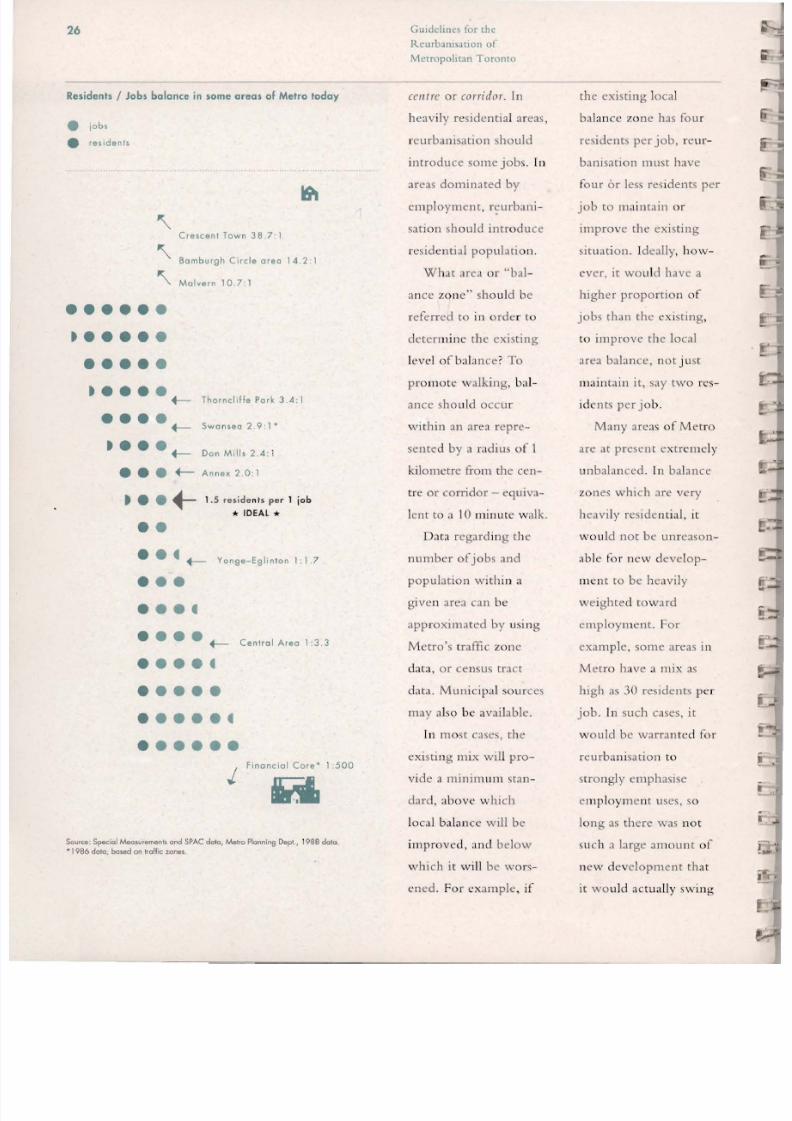
Residents / Jobs balance in some areas of Metro today
• ,ob,
• residents
' \Crescent Town 38.7:1
' \Samburgn Circle crea 14.2:1
'\ . Malvern 10.7: 1
t • • • • •
t • • • f-Tnorncliffe Pork 3 4:••• f Swansea 2.9-\
t • • fDon Mills 2.4:•• f- Annel': 2.0: 1
1.S reside nts per 1 jobt • • . -"" IDEAL ...
• • • f - - Yonge-Eglinlon 1: 1. 7
• • • • f- Co"'ol A,eo 103.3
Finonciol Core- 1:500
.j
Soorce: Special Meolurementl and SPAC doto. /v\etro Plonnin9 Dept .. 19880010
• 1986 dolo, boMd on traffic %Or\4l$ .
celltre or corridor. In
heavily residential areas,
reurbanisation should
introduce some jobs . In
areas dominated by
em p loyment, r ~ u r b a n i -sat io n sh uu ld int rod u ce
n.:sidcn t ial po pu lation.
What area or "b a l
anee zo ne" should be
refer red to in order to
dctc::rminc the ex isting
level of bah nce ' To
pr olllote walking, b:d
anee shou ld occu r
within an area repre-
sented by a radius of I
kilometre from the cel1-
tre or co rridor - equi va
lent to J 10 minute walk .
Data regarding the
numbcr of jobs and
po pulation withi n a
given arca can be
approximated by using
Met ro's traffic zone
data. or census tract
dJta. Mun icipal sour ces
ma y also be availab le.
In mo st cases, th e
existi ng mi x wi ll pro-
vid e a minim uTll sta n
dard, above which
loca l balan ce wil l be
im proved, Jnd below
which it will be wors-
ened . For exam ple, if
th e ex isting loca l
ba lan ce zone has fou r
residents per job, rC lIf-
banisation must have
four or less res idents per
jo b to maintain or
improve the existing
si tu at ion. Idea lly, how -
ver, it wo uld have a
higher proportion of
jobs than the ex isting,
to improve the local
arca balancc, not j ust
lIuintJi n it, say two rt.'s-
idents per jo b .
Many an:as of M etro
are at presen t extremcly
un balanced . In ba lance
zo nes wh ich arc very
heavily residential , it
\:vo ul d not be unreasO Il
able for new deve lop-
mcn t to be heavily
weighted to ward
emp loYlnent . For
example, som\.: areas in
Metro have a mix as
high as 30 residents pe r
job. In such cases, it
wou ld be warran ted for
reurbanisat ion to
stro ngly em phasise
emp loy ment uses, so
long as there was not
such a large amoun t o f
ncw development that
it wo uld actua lly swi ng

8/8/2019 Guidelines for the ion of Metropolitan Toronto
http://slidepdf.com/reader/full/guidelines-for-the-ion-of-metropolitan-toronto 30/70
27
the balan ce of the area
past the "idea l" bal
ance , and so long as th e
centre or corridor itself
did not become a sin
gle- usc district. In most
cases, the numbe r of
j obs and l or rcsidl:llts to
be added to an area
through rcurbanisat ion
will be qu ite small
compa red to the exist
ing po pulation an d
jobs, and suc h an out
come is no t like ly.
T o illustrate . say the
balance zOlle for a ccn-
Ce had an existing pop
uloti on of 15,000
res idents, and 500 jobs
(30 residents pe r job) .
Centre
- '0(01 balance zon.·
Corridor
"" ocol balance zon."
In orde r to achi eve the
"ideal " ba lance in the
zone, alm os t 10,000
jobs wo u ld be requ ired
in the centre (movin g
the f:lria to 1.5 resi
dents pcr j ob) . Th e
re urbanisation of local
cel/tres an d corridors is
no t like ly to in vo lve
such a large am ou nt of
new develo pment and
new jobs. In such a
case, it is morc impor
ran t simply to make
sun: the mi x in the bal
anee zone is im proved ,
as in reality, it may no t
be possible for t he idea l
to be ach ieved . T he
sa m .; log ic app li es to an
existing area that is
heavily employment
o riented .
In som e cases, it may
be appropriate to look
beyo nd the area defined
by wa lkin g distance as
the bas is fo r ba lance.
T hi" will occu r p ri ma r
ily with rcu rbanisation
areas whose areas or
in fl ue nce arc no t j ust
loca l , an d w hic h are
li ke ly to draw peop le o r
workers fro m a larger
catchment a r e ~ Thi'\
GUIDEL INES
26 The appropriate residential/emplaymllnt mix is
determined on a local area basis, in order to pro
mote walking and cycling. The area of reFerence
or "balance zone" is deFined by walking distance,
a radius of approximately 1 kilometre From the
reurbanisation area.
27 In certain instances a wider balance zone may be
considered For the purposes of determining bal
ance. This would occur primarily:
• Where the reurbanisation area plays a strategic
or more than local role, particularly major Metro
cenlres and high density cenlres;
• Where benefits of balancing based on a wider
area outweigh beneFits of balancing based on a
local area .

8/8/2019 Guidelines for the ion of Metropolitan Toronto
http://slidepdf.com/reader/full/guidelines-for-the-ion-of-metropolitan-toronto 31/70

8/8/2019 Guidelines for the ion of Metropolitan Toronto
http://slidepdf.com/reader/full/guidelines-for-the-ion-of-metropolitan-toronto 32/70
29
jobs. Taken together,
these trends represent a
potential for Me t ro to
bec om e a mo re socia lly
and eco nomically r a t i -tied city in years to
co me, with the middle
tier of th e urban popu
lat io n dim inishing.
The cultu ral, linguis
tic, religious and racial
diversity of the
m etropo lis is also
expected to increase .
These parallel but unrc
lated processes of
increasing c ultu r::1 or
linguistic divcrsitica
rio n , cOlllb ined wi th a
potentially m o rL'
polarised urban socia l
structu re could repre
sent a perilous situa
t ion . In tegration of all
social groups, and
Iluillt:l ining a di ve rse..:
economy with a full
range o f jobs withi n
M etro will be
pa r:IIllOunt. An impor
tant component of this
will be physical integra
tion , providing for
di versity, integration,
interactio n and (0111
ll1unity ex pression
within local areas.
One way of doing
this is to ensure d iversi
ty of ho using types
within each lo cal area .
This will not on ly pro
mote integration , bu t
im prove co m munity
stability. Fo r example,
rcurba nisat io ll in the
Leaside arca o f East
Yo rk has in t roduced a
ne w , smaller hou sing
unit type to the periph
cry of that single-fami ly
dwelling com m unity.
T his has permitted
man y of the olde r local
residents to rn ove int o
m ore suitable ho using
w hile re m ain ing in
thei r co mm unity.
ititi In 1990, nearly 40% of
Metro 's population wa s
barn outside Canada.
GUIDEL INES
Mix of Hou.lng Typ • •
28 Reurbanisation should aim to achieve am ,.... 'hou si ng unit types an d sizes within local o·
including a portion of affordable or intrinsically
affordable he>using .
29 Emphasis should be placed on providing afford ·
able housing in all locations throughout the
Metropolitan Region .

8/8/2019 Guidelines for the ion of Metropolitan Toronto
http://slidepdf.com/reader/full/guidelines-for-the-ion-of-metropolitan-toronto 33/70
30
a . . . . LYING 'HE GUIDIL INIS
Determining existing local area balance.
An estimote of the existing residen t population 10
employment mix can be ob ta ined using Metro's traffic
zone dolo USing dolo from surrounding traffic zones,
the existing local population near Victoria Pork and
Danforth is 63,000, and the existing number of jobs
IS 10,000. This translates into a resident to job ratio
of 6 to I . The target balance level for Metro is 1.5
residents per job. New development mus t therefore
occur a t a rotio of 6.0 residents or less per job, in
order to make sure tha t the existing level of balance
is nol worsened. The oreo is heavily weighted toward
residential use.
2 Determining existing wider area balance.
As a high denSity centre. this area will represent a
significant concentration of employment whose orea
of influence will extend beyond the local area. Thebenefits of examining the reurbonisolion are a in ils
larger context should be brought inlo consideration.
Given the high level of exisling Iransit service to this
area, and its location outside the central area in a
predominantly residential par I of Melro, it represents
an excellent location for a concentration of employ-
ment. For Scarborough residents, who can reach the
site by GO train or subway , the area could provide a
much needed alternative employment concentration to
the central area, substantially shortening trip lengths.
For cenlral city reSidents, a job concentration at this
point would make beller counter·flow use of existing
transit facilities and capacity_ In such a case, thereare significant benefits 10 be realised from placing
emphasis on employment In Ihis location
3 What ar e the general mix parameters for the
reurbanisation area?
As a high denSity centre, the general parameters
suggest the mix for this reurbonisation area is likely
to be weighted toward employment, i .e could be less
than 1.5 residents per job.
4 Conclusions
In view of the benefitS of increasing the employment
component, an aggressive approach which emphasis'
es employment is appropriate here, indicating a mix
less than the 1.5 residents per job. A ratio of one resi-
dent per lob could be supported here, or even a
greater employment focus soy 0.75 residents per job .
Guideline\ for tht·
R c u r b a m ~ . l t i o n ofMc-tropolil.lll Torollto
Introducing new housing
types on the periphery of
existing res idential areas
like this one in leaside, can
promote social integration
and community stability.
R-'!!""-':t
'" r \ \ I
r; , " .o-
c.\ . /. ' ..
, . ':, . I - ; •.
... ~ - = = - --'--., - . +. _...
.--::--c:::

8/8/2019 Guidelines for the ion of Metropolitan Toronto
http://slidepdf.com/reader/full/guidelines-for-the-ion-of-metropolitan-toronto 34/70
31
The density, or the inten-
sity of urban use for a
given amount of land area
is related to a number of
important environmental
and community building
objectives. The approach
to density, and the specific
density numbers described
below have been deter-What is themined in order to achieve
appropriate overall ~ t ; : ~ e r Three of these aredensity l e v e l ? e s p e c ~ a l l y important:
redUCIng auto depen-
GII/(/('/i"(,5 for 'h e dency, creating a livable1 ~ ( , I I , b , J / l / s a l l o " of
,\.1rtrt'I}(J/itQPI '{oro"to built environment, and
ensuring diversity of
buildings, living and
work environments.

8/8/2019 Guidelines for the ion of Metropolitan Toronto
http://slidepdf.com/reader/full/guidelines-for-the-ion-of-metropolitan-toronto 35/70
32 G l l l l k l t t l l ' ~ for rhl'
ItL'llrb,llli \.lt io ll o f
Mc:tropolit;l.11 Toro ll to
Thefe ;H C three fun
damental ideas behind
reducing au to depen
de ncy. T he first o f these
is to promote wa lk ing
:'Inc! cycling as viable
means of urban t r ::l I1S-
po rtati o n. Thi s means
achieving certa in Inin i
mu m O VCTJ II densities in
rcu rbani sati o n arC'as .
Secondly, o verall densi
rics sh o uld be high
enough to su ppo rt tr a n
sit service, and L'l1cou r-
Jg c a high moda l sp lit in
fav o ur of t ransit usc .
Fin:!I ly, the app ro ach
outlined bdow t ies th e
o verall density in a rCUT-
banisat ion area to the
level o f transit service
prov ide d there . Fo r
example, a subway has
about te n times the
capacity of a bus or
streetcar. R.eurbanisation
areas serve d by subway
should therefore have
overa ll densities tiu t
reflect this significant
differential in capacity
an d accessibili ty .
These goals should
nev er be achieved at the
expense of a h igh quali
ty built fo rm an d urban
environm ent, however .
T he density levels rec
o mm ende d below are
compat ib le wi th built
forms suited to th e reur
banisati o n area's pos i
ti on in the urban
hierarchy. it's lo cat io n,
an d sur ro un ding
co ntext .
It is :l lso important to
achieve a range of
building forms and
urban environments that
will sup port a wide
ra nge o f economic
activ ities - fro 11 indus-
EXISTING GROSS DENSITIES OF SOME AREAS IN METRO
Corrido rs Resi dents an d
Portions of: Wo rke rs pe r Hectare
Bayview 150
Mt . Pleasant 175
Victoria Park 200Danforth 500
Yonge St . 250-500
Bloor 500
Cent res
Yang. / St . Clair 350-400
Yonge / Eglinton 400-450
Central Area 450
financ ial Co ree 1800
Source: Special runs, Metro Plonning Deportment, 1988 data.
-Source: Traffic ::tone doto, Metro Planning Deportment, 1986
tria l wo rksh ops to co r be nefits asso ciated w ith
porate headquarters. an d be tte r jo bs/ housing bal
a full choice of h ousing ance (few!.:r auto tr ips,
type and cn viro n mcn t - short e r auto trips , lise of
from low-rise town- O l l l l l muting
houses to tru ly urb an transit capacity etc. )
high rise living in major areas w hich have an
A1e/yo cef/tres . appropriate usc m ix can
1-1 igher overall densi sllstai ll higher den si ties
ties also bring the possi than those wh ich do
bility fo r improved 11 0 t . Fo r th is reason, th e
quality of life, bette r o ve rall de nsities pe rm it
lo cal :lmenities, a more ted Jre so m ewha t hi ghnd iversified econ om y ::ll1d than t hose t hat may
op p o rtu n ities, :lI1d :l no rm ally be prl'scribcd
mo re vibrant urban life . fo r areas plann ed m ore
The approach o ut conven t ionally.
lined below builds UpOIl A Illorc de tai led dis-
th e G u idelines o utli ned cussio ll o f thL' rat io nale
to th is po in t, e nco urag beh in d the de nsity
it l g an appropriate mix numb ers can be fo un d
of ho using an d jobs at i ll the companio n
specific locatio ns. repo rt .
I3ccause of the manyaximising densities within Metro will reduce pressure
for development of greenfields sites outside of Metro .

8/8/2019 Guidelines for the ion of Metropolitan Toronto
http://slidepdf.com/reader/full/guidelines-for-the-ion-of-metropolitan-toronto 36/70
JJ
Gross Reurbonisoton
Density
R educing auto depen-
dence and creating a
diversity of places wi th
in the rn t: trop olis are
questions of density
most appro priately
addressed at :l mo rc
I11Jcro level, n ot 0 11 a
site - specific basis.
A c a ~ l I r c o f the
in tensity of urban activ-
ity at a la rger ge ograph
ical scale is appropriate,
in th is case fo r a given
major Nlelro celltre ,
ctl l t re, co rridor or iI/jill
area withi n Me tro .
T radi t io na lly, a " pop u-
latio n per hectare"
measu re has been ll sed
at chis macro selic •
which captures only
residential po pulatio n
an d not e mployme nt. A
pre mise of the appro:l.c h
o utlin ed in the
Oy
If curre.,t ow c! ty
f > t ! r i p h : ~ a l development
00
Source: I ~ :
Guide lines is tha t i ll
making decisions
regarding the natu re of
rcurbanisat.ion , emp loy-
ment lIses an d residen-
tial uses cannot be
co nsidered in j'>olation
frol11 one anothe r. A
new meas ure of density,
on e which captures
bot h employment an d
residents is therefore
proposed: gross rcur-
banisatio n de nsity.
Gr oss rcurban isation
de nsity is a measure of
th e nu m be r of residents
an d wo rkers pe r hectan:
over a large area. A
gross reurban isati o n
density of lOO residents
an d wo rk ers pe r
hectare, fo r examp le,
co uld be comp ri sed of
75 wo rkers an d 25 resi
dents . It appli e, at larg-
er urban scales, and is
used in th est:
G uideli ne s at t he Over
all Icvd o f a reu rba nisa-
ti on area - be it a major
A1ctro [Clltre, [Clllre, [or-
ridor, or j l l j t f l area.
Areas devoted to public
realm and deve lo pm e nt
parcels arc included in
th e land area basis.
GUIDEL INES
30 "Gross reurbanisation density'" is a measure of the numbe
of residents and/or workers per hectare.
31 The "gross reurbanisation density" measures apply to
reurbanisation areas as a whole, that is, to the entire
major Metro centre, centre, corridor, or infill area,
including land area devoted to the public realm.
32 Within the parameters outlined below and in following
sections of the Guidelines, densities should always be
maximised. in order to accommodate the maximum
number of residents and jobs within the already built-up
area rather than on greenfields sites .
33 Lo w Don. l ly Co r r idor.
The appropriate gross reurbanisation density in
low density corridors is 100 to 125 residents and
workers per hectare.
34 Modlum Don. l ly Cor r idor .
The appropriate gross reurbonisotion density in
medium density corridors is 200 to 250 residents
and workers per hectare.
35 Lo w Don.l ty Contro.
The apprapriote gross reurbanisation density in
low density centres is 125 to 175 residents and
workers per hectare.
36 Modlum Don.l ty Conlro •The appropriate gross reurbanisation density j
medium density centres is 250 to 350 residents and
workers per hectare.
37 High Don.l ty Contro.
The appropriate gross reurbanisation density in
high density centres is 400 to 550 residents and
workers per hectare.
38 Malor Molro Conlro.
The appropriate grass reurbanisation density in
major Metro centres is 700 to 1000 residents and
workers per hectare.
39 Gonoral Don.l ly Provl . lon .
It is of course likely that there will be some limited
reurbanisation that will nat fall into the categories of
corridors or centres, such as infill areas. In order to
support the possibility of transit, and to support wa lking
and cycling. such reurbanisation should meet minimum
densities. Gross reurbanisatian densities of 80 residents
and workers per hectare should be the minimum for all
reurbanisation in Metro.

8/8/2019 Guidelines for the ion of Metropolitan Toronto
http://slidepdf.com/reader/full/guidelines-for-the-ion-of-metropolitan-toronto 37/70
34 (, d i for rhe
Rl'urballlsation of
Metropolitan Toronto
APPLYING TH E GUIDELINES
As a high density centre, the overal l gross reurbonisation
denSity of the Victoria Pork/Danforth centre should fall in
the range of 400 to 550 residents an d workers per
hectare.
Using the gross reurbanisatian densities and opplying the
balance ratio determined for the area, above, we can
es timate the tolal number of residents and workers thai
could be an ticipa ted in the centre over the long term
when reurbanisotion is complete. Above we determined
that the resident to job ratio for the centre could be in
the range of 0.75 residents per job (or 1.5 lobs per resi-
den t). Applying this ratio to the gross reurbanisotion den-
sity of 450 residents and workers pe r hectare suggests a
breakdown of roughly 2 70 jobs an d 18 0 residents per
hectare . Over the entire site area of 27 hectares , a total
of about 7 ,300 jobs and 5,000 residents would result.
In turn . we could apply floorspace overages to these
numbers 10 es timate the 10101 amounl of floorspace .
Assuming 50 square metres of floorspace per reSident,
an d 30 square metres per job, the total amount o f
floorspace in the centre would be about 450.000 sq.m ..
Gro ss rCllrba ll isa tio l1
dCIl '\itics ca n be appl ied
to a [e urba nisation area
to estim ate the to tal
numbe r o f re sidents and
total nu mber of wo rk -
ers that mi ght reaso n-
ably result in the long
tcrm whl:11 that arca is
reurban ised (including
any cx istin g res ident or
worker popu latio n th at
re mai ns). It therefo re
providt.:s J useful too l
fo r transportation and
tran sit plann in g, as well
as the plann in g of o th er
in frastru cture slI ch as
pa rks o r schoo ls: After
all , it is re side nts and
worke rs whi ch generate
the need for slich
infrastructure, not
floorspacc pe r sc. Uut it
can also provid e a ba sis
to esti mJte the total
amo unt o f floorspac c
that will ex ist in the
centre or corrido r, as
ill ustra ted in " Ap pl yin g
the Gu idelin es."
Using the Density
Guidelines
D ensity leve ls va ry
de pending upon the
typ e o f re urban isatio n
arc;]. Th ey arc hig hest
in the lII ajor Metro cen-
tres, and lo wes t in lo w
de1J sity co rridors. In
each ca sc , a range is
g ivcn fo r thl' gro ss
reurbanisatio n den si ty.
For a particular rc ur-
banisation area, the
appropriatl' mix deter-
mined in Sec ti on C can
be applied to the gross
rcu rb an isation de nsity
fi gur es, an d m u ltip lied
b y the total area o f the
ce llt re o r co rridor, to
give I n indi cation of
the total number of
wo rkers and re.;s ide nts
that can be expected in
the.; lo ng te rlll.
T he Gu id e lin es also
provi de site spe c ifi c fsi
ranges for each ty pe of
rcurbanisa tio n Jrca, 35
disc lI ss ed in Sec tion G.

8/8/2019 Guidelines for the ion of Metropolitan Toronto
http://slidepdf.com/reader/full/guidelines-for-the-ion-of-metropolitan-toronto 38/70
35
The Urban
Design Plan
Gllitit'll/US for t/lf
Rt' l Irball isOfic1I/ of
j\ / l'trt1!l,Ilitoll Toron,o
Urban design is site
planning at the level of
the city. The combina-tion of the public
aspects of the city such
as parks, streets and
blocks, and sidewalks
with the buildings and
natural environment
creates the wide varia-
tion in urban form that
makes up Metro today.
Many of these combina-
tIons represent system-atic and repeatable
relationships that can be
successfully used over
and over in many loca-
tions throughout Metro.
In other cases site spe-
cific conditions require
a unIque response to
achieve a successful
urban form.

8/8/2019 Guidelines for the ion of Metropolitan Toronto
http://slidepdf.com/reader/full/guidelines-for-the-ion-of-metropolitan-toronto 39/70
36
GUIDEL INES
40 An urban design plan should be prepared in con '
junction with the reurbanisation of major Metro
centres, centres, corridors, an d inlill areas.
41 For the area to be reurbanised and in the context
of its surroundings, an urban design plan should
define , in three dimensions, the fundomental type
of repeatable urban form that the area could
exhibit after reurbanisation, created by the
characteristics of:
• the pedestrian and vehicular circulation system;
• the open space system;
• the distribution of uses over the
reu rbanisation area ;
• the distribution of " 'tt fsi densities
by parcel or sub-area;
• the overall height an d massing of the buildings;
• the relation ship between street and building;
• the primary public entrances;
• the relationship between the type of proposed andexisting bu ilding types;
• integration of new development with
transit service;
• standard s for micro-climate, including
sun/shade, and wind conditions.
4 2 Within a given reurbanisation area, and as a gen
eral pr inciple, employment uses should be placed
closer to transit access points than residential uses .
Exc eptions may occur however, for example with
respect to special needs housing .
GUidelines for th e
R C l l r b ~ l l 1 s J t i o l l of
Metropolitan Toronto
Urban design direct
ly conditions ou r expe
rience of the city. It
determines very rcal
aspects of the urban
experience . sllch as [ h I.:
3111 0unt of sun 0 11 a
park, or the arno un t o f
wi nd on a sidewalk. In
add it ion, it has signifi
cant but indirect im
pacts. It can co n trib ute
to a sense of cO ll1l1lu ni
ty, for example by
identify ing the system
th rou gh which ' mai n
streets ' arc created so
that th ey ca ll be repeat
ed an d expanded. It can
promote a safe urban
envirollment, support
walking and enhance
the vi:1bility of tr:1llsit.
In this section we
recommend th at an
"urban design plan" be
prepared for all lIIajor
Metro eelH res, eelilres,
corridors and ilifill areas.
An urban design plan is
a three-d imensional
plan for the illlportant
urban dLsign aspects o f
an area, including therdJ tionship with th e
surro unding context,
creation or extension of
the public realm, build
ing heights . and so a ll .T he plan is a funda
men tal tool used as part
of a proactive app roac h
to guide the process of
rcurbanisat ion and
make coord inated dec i
sions about uses, dens i
ties, and built form on
ind ivi d ual sites . It pro
vides a clear framewo rk
fu r responding quic kly
:1I1d ratio nally to de vel
opment applications. It
will also help to ensure
that n: u rba nisJtio n
results in a high qua li ty
pub lic rea lm , w ith suf
ficient and well
designed roads, pedes
tria n areas and parks .
T he urban des ign
plans prepared to guide
the evolution of re ur
banisation areas will
allo w for interpretatio n
of the gencral guide
lines to rcspond to thc
special fca tures of cac h
area. This detailed .
area-specific considera
tion will be especially
critical in those areas of
M etro whic h :lrc more
subt lrb:ln in form and
whe rL' reurbanisation
sho uld sec k to create a
fOfl ll that is more (0 111
pact and appropriate to
local co nditions. The
guidelines arc b roadly
descriptive; the princ i
ples th ey assert w ill
require elaborat io n in
an area-specific urba n
design pia l! .

8/8/2019 Guidelines for the ion of Metropolitan Toronto
http://slidepdf.com/reader/full/guidelines-for-the-ion-of-metropolitan-toronto 40/70
• •
37
APPLYING TMI GUIDIL tNI5
,
'! . . ,( ... . ·1 . ...;;
, . J
"-,.;:
Building Heights Net Densities
• commercial
11m mixed use
o residential
Land Use
: ' - ~ . ~ : ; ! : l 1!-.jJ .
'f t." ·r . J ' " ~ iI" ! ! ~ t l ' . )
I, rT ".,
Urban Design Plan
The urban design plan shows on overoll concepl for Ihe
area, including the infi ll areas located south of the rail
corridor. The high density centre is loco ed nor lh of Ihe
rail corridor and along Victoria Park Avenue .
The plan is slruclured around Ihe GO and subway sla'
tions. A major north-south open space is created olong
Victorio Pork linking the two stations and creallng one
comprehensive development node served by Ironsi!. The
relocaled GO slolian is flanked by develapmenl parcels
and becomes a focal point.
A new slreets and blocks structure is established in order
10 rationalize the available space while providing identi
fy 10 the area
The area soulh of Ihe Danforth provides on emplaymenl
focus and includes offices and retail, with light industrial
uses along the rail corridor. Mixed commercial/residen-
lial parcels are locoled along Ihe main square. The
perimeter of the main square is seen as a mixed-use area
with on emphosis on height and density at the intersec·
lion of Danforlh and Viclarla Pork. Danfarlh is reinforced
as the main service corridor with street related retail
Residential uses to the north ensure proper integration
wilh Ihe exisling residenliol neighbourhoods . The overall
result is a highly mixed areo with a strong emphasis on
employment.

8/8/2019 Guidelines for the ion of Metropolitan Toronto
http://slidepdf.com/reader/full/guidelines-for-the-ion-of-metropolitan-toronto 41/70
GUIdelines for the
Rcurbanisatioll of
Mctropohran Toronw
38
APPLYING THE GUIDELINES
L
In order to ma ximise accessibility to Iransi l, employmen t
uses are placed closest to Transit slops, with mixed use
bUildings filling ou l Ihe cenlral square . Residenliol uses
ore placed next 10 the existing residential fabric, in order
to make on appropriate transition between the centre
and its surroundings.
Placing Ihe densesl bUildings nexl 10 Ihe Iransil slops also
maximises occessibili ly 10 GO and Ihe subway, by
pulling more people closer 10 the stalions. Denser build
ings are also appropriate around the central square In
general, fSi densilies of 4X 10 6 X - in Ihe upper end of
Ihe range permilled In high density cenlres, are placed at
the centre, and diminish to 3X in the outer portions. Fsi
densities hove been kepi low 01 the northwest end of the
central pork space, next to the existing low-rise neigh
bourhoods. The bUilding heights follow a similar pallern
10 the site-specific densities, diminishing wilh dislance
from Ihe middle of Ihe centre.

8/8/2019 Guidelines for the ion of Metropolitan Toronto
http://slidepdf.com/reader/full/guidelines-for-the-ion-of-metropolitan-toronto 42/70
39
How much public realm
is required?
When an areais
to bereurbanised it usually
means a considerable
increase in the density
or intensity of use. The
reurbanised area will
need to
The public realm : ~ : : t o
G uid elitl t's fo r ,h e
R ellrba tllSdl ioll of
,\4ctropo litdtl T oron to
people and become the
setting for a more com
plex order of urban life.A single-storey shop
ping centre and car park
is quite a different place
from an urban centre
which includes housing,
offices, workshops,
community facilities
and shopping.

8/8/2019 Guidelines for the ion of Metropolitan Toronto
http://slidepdf.com/reader/full/guidelines-for-the-ion-of-metropolitan-toronto 43/70
40
GUIDELINES
43 The public realm consists of parks, streets, side
walks and other open spaces. Included in the mea'
surement of the public realm for an yreurbanisation area is half of the width of local
streets and arterials which may form the area's
boundary. Expressways and other quasi-public
areas, such as hydro corridors, ar e not counted
toward the public realm as they do not expressly
serve the raurbanisation area. In general, publicly·
accessible private open space would not be count·
ed toward the public realm.
44 The public realm created in the reurbanisation of
an area should be dedicated to the municipality.
Density should not be drawn from portions of thereurbonisation area which constitute the public
realm and reapplied to the development parcels.
4S In major Metro centres, centres, and infil/ areas,
the public realm should constitute a minimum of
30% of the total land area to be reurbanised. This
figure includes public roads, pa 'rks, sidewalks and
other publicly owned open spaces. Any existing
public realm retained as part of the reurbanisation
can be counted toward the 30%.
4 6 Corridors have a somewhat greater amount of pub-
lic realm, as the amount of developable land has
been strictly defined as a depth of one property,
which generally means the street accounts for a
higher share of the corridor's total land area. The
public realm for corridors is ideally between 30%
and 40% of its total land area. Existing public
realm retained as part of the
reurbonisation can be counted toward the
30% to 40%.
C;uidclillt's (or thL'
R c u r b . l l l i ~ J t o l l of
MctropolitJIl Toronto
When such a proces<
of rcurbanisatiol1 takes
place, it is vi tal to pay
careful atte nt ion to th e
crcation uf a publ icrcal m w hich supports
public activity and a
sense of community.
An adequate public
rea lm of streets, si de-
walks, parks and ope n
spaces must be crc :l tcd.
The public reallll
plays a critica l role in
determining the quality
of life in a city, in pro-
viding access to public
amenities such as
ravines o r the water
front , and in providing
public places where
social integration, inte r
action, and community
building can occu r.
In some redevelop-
ment projects over the
past few decades,
streets, parks, buard-
walks, or ravine ed ges
ha ve effecti vel y been
privatised, ei th e r
th rou gh design, or
indeed through pr ivate
ownership.
An associated prob
lem wi th redevelop-
ment projects withi n
Metro in the past has
been that the develop-
m e n t ~ arc simply too
dense; to o big for th e ir
site. One sou rce of th is
problem is that densi ty
is attributed to the
I.:lltirc r "gross" sitc to
be redeve loped . Wh enthe streets and parks arc
laid ut , the density
fro lll these areas is th en
app lied to the develop
me nt parcels , in addi -
tion to the that
is already perm it ted
the re .
T his is :U l un pre-
dictable process, in that
the real ne t de nsities
that result wi ll depe nd
upo n the amount of
roads and parks created
011 th l.: site . Frequ ently ,
th e resulting amount of
density applied to the
developm en t parcels is
...imply too great , creat-
ing bui ldings that are
too b ig or to o tal l.
Wh en greenfields
sites arc urbanised for
the first tim e.: through :l
Plan o f Subdiv i ... ion , th e
pu b lic rea lm is dete r
mi ned and dedicated to
th e municipality. N o
An open grid street system
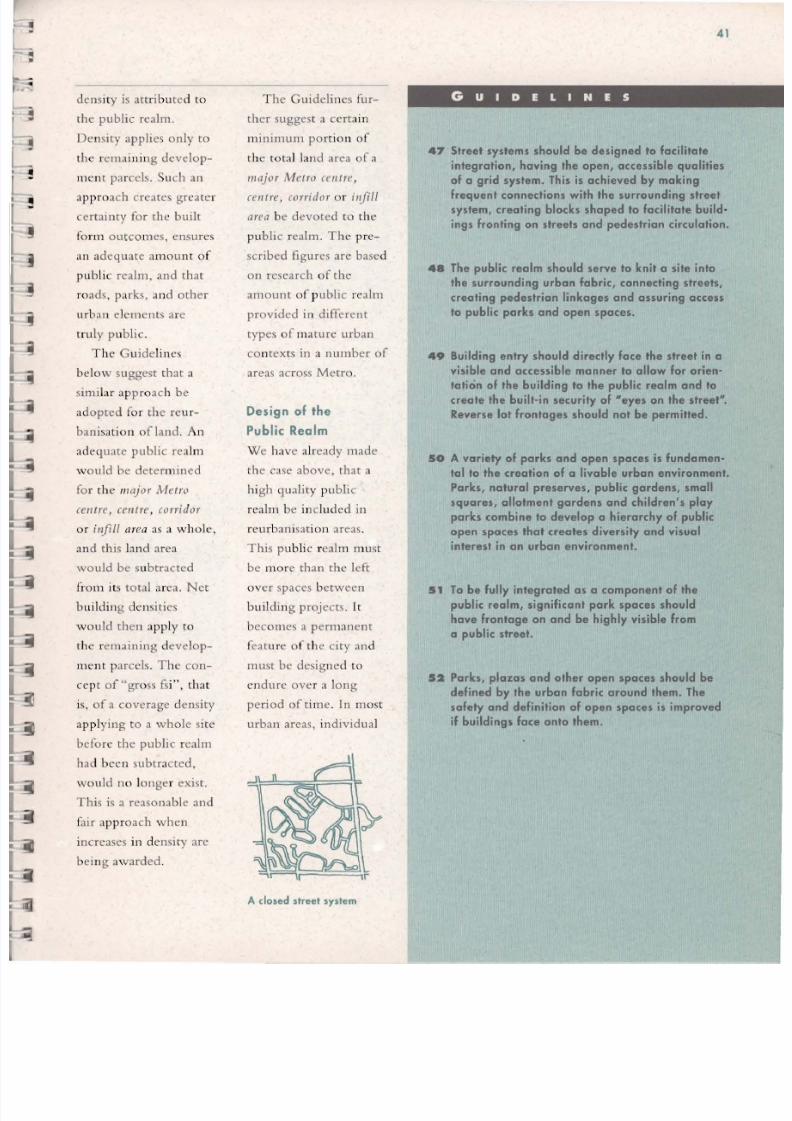
8/8/2019 Guidelines for the ion of Metropolitan Toronto
http://slidepdf.com/reader/full/guidelines-for-the-ion-of-metropolitan-toronto 44/70
41
T he Guidelin es fur-
ther suggest a certain
m inimum port io n o f
th e to tal b nd area of a
major Metro celltre ,
celltre, corrido r o r il!fill
area be devoted to th e
pu b lic rea lm . T ht.: pre-
scribed figure s are based
on research of th e
amount o f pub lic rca lm
prov ide d in d ifferent
types of m ature urban
co n texts in a number of
areas ac ross Metro .
Design of the
Public Reolm
W e hav e already made
th e case above, that a
hi gh q ualit y pub lic
real m be incl ud ed in
rc ur banisat io n areas .
T h is p u bli c rea lm mu st
be m o re than the lef t
ov er spaces between
buildi ng p rojects . It
becom es a pe rm anent
fca tu n..: of the ci ty an d
mu st be des ig ned to
en dure ov e r a long
pe riod of t im e . In most
urban areas, ind ividual
" A dosed street system
GUIDEL INES
47 Sireel syslems should be designed 10 lacililate
integration , having the open, accessible qualities
01 a grid syslem. This is achieved by makingfrequent connections with the surrounding street
syslem, crealing blocks shaped 10 lacililale build-
ings fronting on streets and pedestrian circulation.
411 The public realm should serve 10 knil a site inlo
the surrounding urban fabr ic, connecting streets,
creating pedestrian linkages and assuring access
10 public parks and open spaces.
49 Building enlry should directly lace Ihe slreel in a
visible and accessible manner to allow for orien-lalion ollhe building 10 Ihe public realm and 10
create the builHn security of "'eyes on the street".
Reverse lollronlages should nol be permitted.
50 A variety 01 parks and open spaces is fundamen·
tal to the creation of a livable urban environment.
Parks, natural preserves, public gardens, small
squares, allolmenlgardens and children's play
parks combine 10 develop a hierarchy 01 public
open spaces that creates diversity and visual
interest in an urban environment.
51 To be fully inlegraled as a camponenl of Ihe
public realm, significanl park spaces should
have fronlage on and be highly visible from
a public slreel.
52 Parks, plazas and olher open spaces should be
defined by Ihe urban labric around Ihem. The
salety and delinilion of open spaces is improved
il buildings face onlo Ihem.
dens ity is at t ribu ted to
the public rea lm.
Density applies on ly to
the rem aini ng deve lop -
ment pa rcels . Such an
approach creates greate r
certainty for the buil t
fonn outco mes, ensures
an adequate am o unt of
publi c [calm, and that
roa ds . par ks, and othe r
ur ban clem ents arc
tru ly p ublic .
T h e G u ide lines
below suggest that a
si m ilar ap pr o ac h be
ad opted fo r th e reur -
ban isati o n of land . An
ad equate pu b lic realm
w ould be determ ined
fo r rh e major Met ro
centre, ceutre , corridor
o r ;,ifill area as a wh ole,
and this land area
would be subtracted
fr0 111 its total area . Nc t
b uil d in g de nsi.t ies
w ould th e n appl y to
the rCIl13i ning deve lop-
ment parcels. T he con-
ce pt of "g ro ss fs i" , that
is, of a coverage density
appl ying to a whole sit e
befo re th e public realm
had been subtracted,
wo u ld 11 0 longe r ex ist .
Th is is a reasona bl e an d
fai r ap pr oach wh en
increases in dens ity arc
bei ng awarded .

8/8/2019 Guidelines for the ion of Metropolitan Toronto
http://slidepdf.com/reader/full/guidelines-for-the-ion-of-metropolitan-toronto 45/70
42
buildings will change
several times in rebtio n
to a relatively stable
public realm . That pu b-
lic rea lm has a lot of
C0l111110n character istics
that will reappea r in all
parts of M etro.
There have bee n
some problems with th e
treatment of the public
rca lm in Metro in the
past . Some redevelop-
ment projects in M et ro
"turn their backs" 011
th e surrounding area,
and create an inward-
looki ng, detached
world . " R. everse lot
fro ntages" , where th e
back of lots face th e
main street , arc an
example of th is.
The pattern of stree ts
and blocks in many
areas, with limited
points of entry to a
block Jn d curvilinear
street patterns , also
inhibits the integration
of an area with its SUf-
roundings. Walk s to
transit sto ps or sto res
arc lengthen ed , andtransit vehicles ca ll find
it diffi cul t to manoeu
vr e th e w indin g streets .
A morc op e n, inte-
grated pattern of stre ets
an d blocks integrates
neighbourin g portions
of the city, redu ces
walking distances, and
promotes accessibility
to transit sto ps. Th ere is
a growing fecling that
an open grid of public
streets actually has less
traffic co ngestion than
the limited access,
closed stree t systems.
Building entrances with
direct access to th e
str ee t promote safety,and make wa lking more
in teresting .
Parks, plazas and
open spaces playa criti
ca l role in th e crea tion
of the distinct characte r
of a neighbourhood -
so much so that many
existing neighbour-
hoods carry the name
of the adja ce nt public
open spaces. Open
spaces can ::t1so provide
a means of linking a
reurbanisation area with
th e surrounding com
munity.
Th e size, usc, loca-
tion, stree t frontage andtype of buildings sur
rounding an open space
systen1 are a critical
co mp o nen t of the urban
de sign plan for an area
of rcurbani sa tion.
GUldeltn cs for the
R curbanisa tion of
Metropo li tan Toronto
APPLYING THE GUIDELINES
As a centre , the general
principle of allacoling a
minimum of 30% of the
land 10 be reurbanised 10
roods and parks applies.
Because of its prior use
as industrial land ser-
viced by rail, there is vi r
lua lly no public reolm in
place in the existing
area. A new system of
streets, sidewalks and
parks will have to be cre
ated as a framework for
reurban isation. An open street pattern facilitates accessi
bili ty to and within the centre, connects to the surround
ing area , and picks up on the existing stree t pattern
around the centre. The new system of streets and blocks
proposed in the pion is a generous one , intended to give
a strong sense of identity to the new centre. Overall , the
public realm shown is aboul 40% of Ihe 10101 land areo
of the centre, surpassing the 30% minimum recommended
in the Guidelines.
An urban design plan for the area must preserve and
enhance all existing natural features. In addition, Victoria
Park is shown as a park-like avenue, linking existing nat
Streets and blocks
ural sites such as the
ravines to form on overall
park/ open space syslemalong a north-south axis.
The cenlrol landscaped
mall along Vicloria Park
Avenue p rovides for a
dist inctive framework for
developmenl 01 a higher
densily while providing
bOlh visual ond physicol
amenity along its length.
H
The park system

8/8/2019 Guidelines for the ion of Metropolitan Toronto
http://slidepdf.com/reader/full/guidelines-for-the-ion-of-metropolitan-toronto 46/70
43
In Section D , above, we
outlined gross reurbani-
sation densities, stated
in residents and workers
per hectare, that would
apply overall to the dif-
ferent types of reurbani-
sation area. This gross
measure of density is
Site-Specific appropriate at t h ~ macro scale, and IS
• • linked to goals such as
Densities promoting walking as a
means of urban trans-portation or supporting
Gllid(linrs fo r the
Rrurbanisl1tlOn of the use of transit.Jhtropolitan Toronto
Within this gross
reurbanisation density
framework, the issue of
building densities on
individual development
parcels appropriately
becomes primarily a
matter of urban design.

8/8/2019 Guidelines for the ion of Metropolitan Toronto
http://slidepdf.com/reader/full/guidelines-for-the-ion-of-metropolitan-toronto 47/70
44
GUIDEL INES
S3 Within a reurhanisation area, a range of site·
specific densities can be accommodated within the
overall gross reurbanisation density figure . Net
1I00r space index ("lsi") figures are provided for
each type of reurbanisotion area . Net hi means
that the density figures can be applied only to the
development parcels; no lsi density is attributed to
land in the public realm .
54 The appropriate floor space index density for any
individual development parcel in a reurbanisation
area will be determined on the basis of an urban
design plan (Section E).
55 Low Den. l ty Corr idor .
Site specific density within low density
corridors is 2X the area of the lot, net.
56 Medium Den. l ty Corrldora
Site specific density within medium densi
ty corridors is 3X the area of the lot, net .
57 Lo w De nsity Centre
S,la opc" fic density wilhin low density
centr , 2-3X the area of the lot, net.
58 Medium Den. l ty Centre .
Site specific density within medium densi-
ty centres is 2-4X the area of the lot, net .
59 High Den.lty Cent re .
Site specific density within high density
centres is 3-6X the area of the lot, net.
60 Malar Metro Cent re .
Site specific density within mojor Metro
centres is 4- 12X the area of the lot, net .
GUl<lclilH.'\ fo r the
u r b a l l J t l O n of
Metropolltall T oronto
Building density ranges
are provided in th is scc
cion of th e Gu idel ines
for each type of reurban
isation :1rC3. Tht;sc sitc
specific densit ies arc
consistent with the (O f -
responding gross reur
banisatiol1 densities .
The site-specific dcn
sity measur e is the floor
space index (fsi), which
is the total amount of
floorspace in a bu i ld ing
div ide d by thc net site
:lrc;:t of an indiv idua l
development parcel , that
is, afte r th e public n:alm
ha'\ been subtracted. Th is
measure indicates the
m in imu lll and maximul1l
fs is w hic h arc anticipated
for the various nc t de ve l
opmcnt parcels within
each lIIajor Metro eellfre,
eelltre or corridor.
The distribution of
nc t fsi densities within
the rcurbanisat ion area is
dete rmined on the basis
of urba n design co nsid
erations . T he f.;;i de n sity
available upon any given
APPLYING '"I
individua l develop men t
pa rce l w ill be deter
mined by the urban
design plan, th e parce l's
location within rhe rcur
ballisat ion area, and the
other general urban
de sign guidelines prc
scnted in th is document.
Most dt.:vclopmcnt
parcel.;; w ithi n a major
IV/etn) (el l tre or (el l tre
may not be rccommend
cd for th e highest fs i Iim
its in the range .
The ne t fs i dens ities
recommended arc also
consistent with the goa ls
of creat ing a livable
urban environment, an d
appropriate built forms .
Fo r example , site-specif
ic densit ies of over 4X
ne t coverage would be
pcrmittL'd only in high
dell sity (Clltres or major
Metro (ClltrcS . Net fsi
den.;;ities of ove r oX
wou ld on ly be perm itted
in major Metro (elltres,
that is, w ithin only 3.
very few locations
in Metro .
GUIDIL IHES
The nel fSi densities are dis-
tribuled so as 10 lake advan·
loge of Iransil access poinls,
ond 10 ensure a Iransition wilh
Ihe exist ing conlexl. As such,
Ihe highesl densily buildings of
5X to 6X are placed in lhe most
central ond prominent positions,
01 the corners of Danforth and
Victoria Pork, and near the Heand GO sto lions. lower densi-
lies of 3X 10 4X occur on Ihe
perimeter of the centre

8/8/2019 Guidelines for the ion of Metropolitan Toronto
http://slidepdf.com/reader/full/guidelines-for-the-ion-of-metropolitan-toronto 48/70
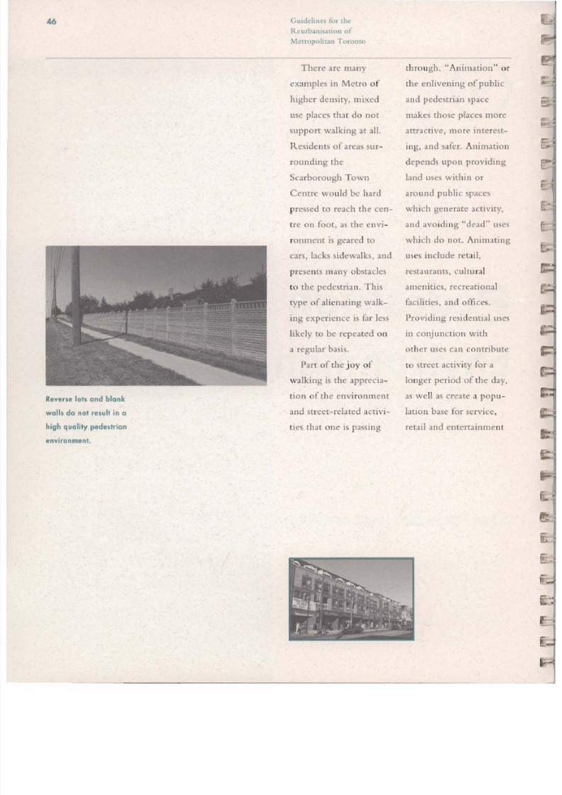
8/8/2019 Guidelines for the ion of Metropolitan Toronto
http://slidepdf.com/reader/full/guidelines-for-the-ion-of-metropolitan-toronto 49/70
46 G u i d t : l i l t ' ~ for (he
R c u r b J . n i ~ l 1 1 0 of
M etropolitan To rOllto
Reverse lots and blank
walls do not result in a
high quality pedestrian
environment .
There arc many
examples in Metro of
higher density, mixed
lise places tha t do not
support walking at all.
Ilcsidcnts of areas Sl I [-rounding th e
Scarborough Town
Centre wo uld be hard
pressed to reach the CCI1-
Cre on foot, as th e cnv i-
ranment is gcared to
cars, lacks sidewalks. an d
prese n ts many obstacles
to th e pedestrian . This
type of alienating walk
ing expe rience is fa r less
likely to be repeated o n
a regular basis.
Part of the j oy o f
wa lking is the apprecia
tion of the envi ro nment
and street-related activi
ties that on e is passing
thro ugh . "Animation" or
the enlivening of public
and pedestrian space
makes those places morc
attractive, morc intercst
ing, and safer. Animation
depends upon providing
land uses within or
around public spaces
which generate activity,
and avo idi ng "dead" uses
which do not. Animating
uses include retai l,
restaurants, cultu ral
amenities, recreational
f.,cilities, and offices .
Providing residential uses
in conjunction with
other uses can contribute
to street activity for a
lo nger period of the day,
as well as create a popu -
lation base for scrvice ,
retail and entertainmcnt

8/8/2019 Guidelines for the ion of Metropolitan Toronto
http://slidepdf.com/reader/full/guidelines-for-the-ion-of-metropolitan-toronto 50/70
47
uses at stree t leve l.
De ad uscs includ e park-
ing lots, thl.: rcar of lot s,
and bbnk walls.
Du rin g the design
process, co nsiderati o n
m ust be given to th e
p hysical image and
po sition of a stree t in
t he urban hierarchy .
Special conditio ns such
as a ce nt re lan dsca pe d
median, multiple rows
of tree pbntings o r
extra wide sidew alks
become pe rmanen t fea-
tures in the urban en vi-
ron m en t and create a
spec ial neighbo urh ood
or community identity.
Li ghting, signage,
spec ial pavement treat-
ments, and street fu rni
ture shou ld be
co nsidered as finish ing
elements of th e street
infrastr ucture.
Not all pedestr ian
environ m ents require
the sam e treatmen t to
provide a successful
walk ing system in a
neighbourhood. An
area's ur ban de sign p lan
should delin eate impor-
tan t pedestria n co nnec
tions whic h link origin s
and destinations. It is
importa nt to remembe r
that a great dea l of th e
successful wal king en vi
ronment in the older
areas of Metro is a sim-
pie, repe t itive sidewalk
syste m al on g the op en
grid of publ ic streets.
" ....;:.. - .... " " ., ,,-.:r . . : ; r .. ,
at.;.: ...... 111
.... 1 ....... " .-. a. J- IJJ L
, ~ , ~ .., .. , , : - ... ~ """-.. .....':10..
GUIDEL INES
61 Reurbanisation should stress improving the con·
nectivity of places by pedestrian means, through
a system of pedestrian linkages.
62 The quality of the pedestrian environment can be
improved by attention to continuity, animating
uses, and improving visual interest an d activity of
pedestrian spaces.
63 Maintaining the continuity an d variety of a pedes ..
trion environment is an important element of its
attractiveness. The public realm and, in particu
lar, public spaces should be surrounded by land
uses which will enliven them.
6 4 The pedestrian environment of arterial roads
could be substantially improved by encouraging
street edge building.
65 Specific elements in streelscape design include:
• provision of adequate sidewalks
• pedestrian scale lighting
• crosswalks and signalisotion to encourage
pedestrian movement
• s.reet tree planting
• special features such as boulevards,
medians an d public art.
6 6 Special tree planting an d street or landscape fea-
tures should be considered in locations where a
special community focus is appropriate.
6 7 In areas of significant pedestrian activity,
consideration should be given to the require ..
ment for weather protection devices such as
canopies, awnings, arcades an d colonnades.

8/8/2019 Guidelines for the ion of Metropolitan Toronto
http://slidepdf.com/reader/full/guidelines-for-the-ion-of-metropolitan-toronto 51/70
48 Guidchm-') for the
Reurbani ..atlol1 of
Metropolitan Toronto
APPLYING tH I GUIDILIN!S
The new north-south linear pork space connects the two
Ironsit slolions 01 the north and south ends of the centre.
Generous, treed sidewalks with weather protection pro
vide a pleasant environment for the shorl walk between
the two stations. Streets ore lined with animating uses,
including relail 01 grade.

8/8/2019 Guidelines for the ion of Metropolitan Toronto
http://slidepdf.com/reader/full/guidelines-for-the-ion-of-metropolitan-toronto 52/70
49
Parking
•
Guidcllllt's fo r t i l l '
f?'t' lI,bll'lI sa t,o" (if
,".1f.'tr0I'0litl1f1 Torot/to
The treatment of parking
IS Important In many
respects - It can con-tribute to or detract from
the quality of the urban. .
enVIronment, It can
promote or inhibit walk-
ing and the use of transit.
By separating land
uses, surface parking
increases walking dis
tances, and can create
an uninspiring urban
environment. Whensurface parking is pro-
vided it should not be
permitted to reduce the
quality of the public
realm. Buildings and the
public realm, especially
sidewalks, should be
contiguous; parking lots
should not separate a

8/8/2019 Guidelines for the ion of Metropolitan Toronto
http://slidepdf.com/reader/full/guidelines-for-the-ion-of-metropolitan-toronto 53/70
50 G l i l l l ' ~ (o r t he
b l J . o f
Metro po li ta n T oronto
GUIDEL INES
8 Surface parking should not be placed so as to
separate the public realm and building entrances.
9 Surface parking should not be permitted in
park spaces.
0 Parking structures which face onto a street should
be lined with active land uses at grade to enliven
the public realm.
In determining parking requirements, the relation-
ship between parking supply and transit use
should be considered. In general, greater provisionof parking will encourage auto use over transit. In
areas of good present or future transit use, signifi-
cantly reduced parking requirements could be con-
sidered.
2 In mixed use development, parking requirements
may be reduced on the basis that the demand
created by different land uses could share common
facilities.
3 Entrances to surface parking or underground park·
ing lots should be carefully controlled when they
occur across a public sidewalk. In the case of shop-
ping streets, vehicular access should occur from a
rear lonewa y .
4 Street parking should be encouraged where it does
not interrupt transit op e rations.
bui ld ing en trance fro m
th e street an d sid ewa lk.
Parking should be
located so as not the
break t his contiguity.
The availability o f
park ing can encourage
peo ple to use their car
instead of tran sit . T he
supply of park ing pro-
vided in an area sh o u ld
take int o accoun t th e
future transit framc-
work; if a good leve l of
transit service is provid-
ed or will be provided
in the future , the sup-
ply o f parking can be
reduced or eliminated,
or the onus sh ifted to
ha"ve the proponent
demonstrate wh y any
parking is ne cccssar y.
Wh ile th e absence of
slIrf.1ce pa rking is
desirable in a nu turc
condition , it may be
necessary in locations of
signi ficant autom obile
lise to deve lo p a ph asedpark ing strategy as a
part of the urban des ign
plan fo r an arca.
Ta this end, surf.1cc
parking should no t be
allov/cd as a permanent
lise in those loc at io ns
where transit alterna-
rives currently exist o r
i ll ex ist in the futun::.
Temporary surface
parking polic ies can
help in the initi al p has-
es of a re ur ban isat io n
proposa l while allo w ing
fu ture deve lopment [0
rc move the parking
o ver time .
In determinin g
app ro priate levels fo r
th e supp ly of pa rki ng,
con siderat io n co uld also
be given to th e C ct tha t
by m ixing diffe rent
la nd uses w hich ge ner -
ally ge nerate park in g
demand at different
times of th e day, th e
overa ll supp ly of park-
ing can be red uced. Fo r
example, in a con do-
minium Jnd o ffice
develo pmc nt , office
workers w ou ld req u irc
dayti mc parking while
reside nts wo uld require
nighttime parki ng, sug-
gesting th at they co uld
share so me of the same
parking f.lcilities.

8/8/2019 Guidelines for the ion of Metropolitan Toronto
http://slidepdf.com/reader/full/guidelines-for-the-ion-of-metropolitan-toronto 54/70
51
Fit and
Transition
Gllideliuc s fo r th e
RCllrba,,;sat;oll of
Ml'tropo/itall Toronto
Some past redevelop-
ment proj ects in Metro
have resulted in verylarge or tall buildings,
which are out of con-
text with their sur-
roundings. In part, this
has been due to the use
of "gross fsi" density
measures, an approach
which these guidelines
suggest should be elimi-
nated (Sections F and G).
But in addition, localzoning controls have set
many constraints, such
as minimum setbacks or
maximum lot coverage,
which have encouraged
high rise buildings.

8/8/2019 Guidelines for the ion of Metropolitan Toronto
http://slidepdf.com/reader/full/guidelines-for-the-ion-of-metropolitan-toronto 55/70
52 Gllldclll1l:S for the
RcurballlSJtlO1l of
Metropo li tan Toronto
Older areas of the city hove
high ucoverage" buildings
i.e., the building foot print
tokes up a large proportion
of the lot.
I1- ,
I 1 - - 1 i " ,1 -_ _ _ 1
r1-
I - 1......1"
Post-wa r buildings have
often had low lot coverage
like this area in Metro .
III other cases (all
buildings were market-
ed for th e lon g views
they offered residents.
Older areas of the city
have high "coverage"
buildings i .e . , the build-
ing footprint takes lip a
large proportion of th e
lot . Often thl· vicw
from these buildings is
only good until another
highrisc occurs in close
proximity. In many
casco;; these high risc
structures have nothing
to do with th e compo-
<;itiOI1, scale or building
type of the urban form
arollnd them.
It is not possible, nor
is it desirable to pre-
scribe uniform building
heights for rcurbanisa-
[ion areas that would be
applied mechanically
:lCr055 Metro. In a very
general way, however,
the guide lin es in this
section suggest 3n alter-
native approach to the
current practice of jux-
taposing very high an d
very low buildings. The
Guid elin es suggest that
much morc extensive
usc be made of low (up
to three storeys) to
medium risc (fouf to
e igh t storeys) buildings
that, because they l I t i
li ze a hi gh coverage of
the.:.' site, arc higher den-
sity but not high rise .
A variety of building
types can still be
achieved within these
paral1leters. The most
H,itablc building type
will be determined by
location, context and
lI SC. One of the values
of this type of building
a great ability to '\uc -
ccssfully in tegrate ne w
development with the
existing Metro urban
st ru cture .
Tall buildings (over
eight storeys) arc not
c1imillZltcd, but arc
restricted to a few
appropriate locations ,
like the centre" of rCUf
banisation areas, corner
locations. or places of
high transit accessibility.
R eurban isation areas
have been well defined
in th e preceding guide-
lines. Firm boundaries
arc necessary in order
to create an orderly an d
scn<; iti ve transition into
cxi<;ting surrounding
areas. A gradual transi-
tion in height ensures
that new development
is compatible with
existing .
These guidelines
shou ld be used as prin-
ciples to assist in th e
preparation of an urban
design plan. In most
cases great sensitivity to
th e specific location
will be req uired to suc-
cessfully create a transi-
tion into 3n existing
community.
Net densitie s of 3X hi can result in high ri se or low rise
buildings, depending upon the coverage .
There should be a gradual, consistent transition in building
heights from a center or corridor to surrounding areas.

8/8/2019 Guidelines for the ion of Metropolitan Toronto
http://slidepdf.com/reader/full/guidelines-for-the-ion-of-metropolitan-toronto 56/70
53
GUIDEL INES
75 The height, size an d typology (i.e. characteristics,
fronts, backs, locations of entrances, etc. ) of build·
ings introduced into an existing urban Fabric shouldbe compatible with what exists. This does not mean
that they must be exactly the same size or have the
same floorplates, but they should have proportions
that do not result in an abrupt change and that do
not IIdwarF" the existing fabric.
76 In larger areas of reurbanisotion, it is important
that a transition in scale be achieved between the
new develop ment and the existing fabric. Taller
bu ildings can be accommodated in appropriate
location s, providing that there is a positive contribu-
tion to the urban fabric.
77 In reurbanisotion areas bordering low-rise residen
tial areas, residential uses will normally make a
better transition use , and are most appropriate at
the edge of reurbanisotion areas.
78 The principles of built form which apply tl? reurbani·
salion in general should also apply to affordable
housing, which shou ld not be given additional
height or density to make it work economically. The
additional costs of this form of housing, if an y, mustbe met through other mechanisms.
79 n the case of Q new community focus which seeks to
convey a specific image, diHerent from the context,
the project must be evaluated as to its impact on the
existing physical character of the neighbourhood.
Within the parameters of a comprehensive urban
design plan , the specifics of building transition will
vary depending on the location within Metro.
80 In low and medium density centres .
Generally low and medium densily cenlres should
be composed of structures under 6 to 8 storeys. In
order to create a transition, buildings should be lim -
ited in height when adjacent to ex is ting low rise
neighbourhoods. Immediately adjacent to low rise
houses a height limit of 3 storeys is desirable. When
separated by a public street, park or other permo·
nent open space, 4 to 5 storeys could be compatible.
81 locations which can be described as landmark loco·
tions in a specific neighbourhood ca n be considered
as exceptions.
82 Along Urban Corridors.
Generally, along urban corridors a base height of 5
storeys at the street line is ·acceptable. It is possible
that this base height will require modifications
downward to adjust to special site conditions or
upward to 8 storeys in special locations su ch as
important intersections or transit stations.
83 Along Suburban Corrldo.. ,
Generally suburban corridors have road right· of·
wa y widths that are wider than urb a n corridors and
a base case of 7 storeys might be appropriate. Site
specific review may suggest upward or downward
adjustments , with increases up to 9 storeys in spe-
cial landmark locations or at major intersections .

8/8/2019 Guidelines for the ion of Metropolitan Toronto
http://slidepdf.com/reader/full/guidelines-for-the-ion-of-metropolitan-toronto 57/70
54 Guidclinc.:s for the
Rcurbanislcion of
Metropolitan Toronto
APPLYING THE GUIDELINES
The overall distribution of heights is such that the tallest
bUildings are placed at the centre of the reurbonisalion
orea, and bUilding heights decrease with distance from
the centre , from ~ i g h rise 10 medium rise 10 low rise.
landmark bUild ings over 15 storeys are placed at the
north end of the new central park, serving 10 define and
anchor the area. Taller buildings ore also provided for
on each of the four corners althe Danforth/Victoria Park
intersection.
Nex t to the existing residential orea, bUildings on the
central square ore limited in height, stepping down from
six storey ~ m o i n slreet" type bUildings on the street
frontage, to two storeys 01 the rear next to the existing
houses . The property depth between the new bUildings
along Victoria Park and the existing houses is in the 35
to 45 metre range This depth combined w ith the low
building heights creates a good transition between old
and new areas.

8/8/2019 Guidelines for the ion of Metropolitan Toronto
http://slidepdf.com/reader/full/guidelines-for-the-ion-of-metropolitan-toronto 58/70
55
Special
Features
Gllitielilles for tile
l ~ e l / r b a I l I S a t l o " of
,\Il'lropolitall TOT<,"to
Both waterfront and
ravine park locations are
special features in
Metro's urban fabric
and should invite public
access. High rise struc-
tures are often predomi-
nant along these special
locations, capitalisingupon private views . The
Don Valley/Taylor
Creek park system is
edged by high rise
structures, for example.These structures limit
public access to both
the top of bank and the
lower park system. The
combined size of the
row of high rise struc-
tures also separates the

8/8/2019 Guidelines for the ion of Metropolitan Toronto
http://slidepdf.com/reader/full/guidelines-for-the-ion-of-metropolitan-toronto 59/70
56
GUIDELINES
4 The edge treatment of ravine and waterfront loco·
tions is a key element of the public realm. Any new
development should create an edge condition thotincorporates a public street and/or park system and
controls building scale.
5 Metro's recent endorsement of a waterfront trail
along lake Ontario means that such a trail should
be incorporated on all properties which front onto
the lake. A minimum waterfront linear corridor
width of 7.5 to 15 metres has been identified and
must be adhered to for all new development.
6 Where the reurbanisation of large areas occursthrough comprehensive planning, the public realm
olong the waterfront should be maintained at a min·
imum width of 50 metres.
7 Along waterfront locations, public access is critical
and the scale of building beyond the 50 metre public
space should not form a wall between the lake and
the city fabric. Building height along waterfront
locations should be controlled by an urban design
plan which establishes the scale, character and loco·
tion of both public and private facilities in these spe·
cial waterfront locations.
Table land parks should be created in ravine edge
reurbanisation projects to create "lobbies" to the
extensive valley land parks system. Development
should be set back through use of a publicly occessi·
ble easement or public land dedication to a mini·
mum of 10 metres from the top of bank to allow for
a walkway, bicycle trail and access to valley land
park systems.
Building heights along ravine edges should general·
Iy not exceed 6 to 8 stories in height. The scale of
edge structures must be sized to ensure compatibility
with the ravine setting and to ensure the enjoyment
of the notural scenery from the valley floor.
0 Microclimatic effects an d conditions in existing parks
and public spaces should be considered for all reur·
banisotion areas.
Guidelines for the
R Cllrballis.atio n of
Metropol itan To ronto
remaining neighbour-
hood from the natural
amen ity. From the val
ley floor park system
the imposing mass and
scale of the high ri se
structures dctr :1cts from
the quality of the op en
space experience ava il
able to the larger popu-
lation of Metro.
In many locations
the waterfront is simi
larly separated from the
city by high rise struc-
tu res. The relationship
betwee n a de nser mo re
compact urban envi
ronment and the access
to natural features is
critica l to th e success of
a neighbo urhood. The
rebt i vc cl oseness of the
buildings to th e water-
front in the Beach is
more than offset by th e
ready, regular an d easy
vi sua l and physical
access to th e- water
fro nt .
T hese spec ial urban
features m llst be criti cal -
Iy evaluated in an area
of rcurbanisation to
ensure that a broad
enjo yme nt of the value
of these areas is possible.

8/8/2019 Guidelines for the ion of Metropolitan Toronto
http://slidepdf.com/reader/full/guidelines-for-the-ion-of-metropolitan-toronto 60/70
Applying the
Guidelines:Examples

8/8/2019 Guidelines for the ion of Metropolitan Toronto
http://slidepdf.com/reader/full/guidelines-for-the-ion-of-metropolitan-toronto 61/70

8/8/2019 Guidelines for the ion of Metropolitan Toronto
http://slidepdf.com/reader/full/guidelines-for-the-ion-of-metropolitan-toronto 62/70
57
APPLYING THI GUIDILINIS IXAMPLI ONI
Corndor.. rc-pn:sent a dif these location .. the origi of W.lrdl:1l AVelllll:. AtA Mcdiunl fl'rr.:Ju context for reur nJI Inllit form i.. Llrgcly prl'SeIH the "frCl:t coml\tS
b , 1 I l i ~ J t i o n than the CJ"e of ..till in P!.Kl'. A .. trong of 1950\ \trip null"
the centre \Ve have sho\Vn Jutomobi le orient.ltion with parking fronting on
.lboVl'. In the following hac; gre.Hly aOt'cred the l.awrellce, and som(' more
e:-.:.llllple . the G uideline.. rdat lomhlp\ betwl'cn site [ l 'n ' l l t mediulll to high
Density
Corridor are applied to a lIIedilflll and buildlllg. Again, the rise residential redevc:lop
t/l'flsiry (("r it/or . The scheme that rnult .. IS ment proJccts.
locnion cho"el1 i ..HI intl'nded only to dlu"tratl' lmllledi,ltely behind
CXJlllpk of a .. ignifical1t ho w thl' Cuidelines might the Llwrel1rc AVClHll'
ft.'urbanlsatlon rl'source ill be applied when a illlear p r o p e r t l e ~ , Oi l both qde",
the Metro context . area I .. being comidl'fed of thl' strect. ,lTl' low risc
Corridors outside of the for reurbanisation . singk faillily dwelling
oldn urban areas h:l.VC a f he corndor 111 q U l ' ~ - I 1 c I g h b o l i r h o o d ~ dOl1llllatcd
form that IS "llllliar to the !Ion I.. .1 "ection of by wide frolll,lgl' i o t ~ and 1
wdl rccognizl'd lIlain l awrence AVl'l1UC which 112 storl'y bU1ldlllbH;.
..tn.'l't ... although larger in extcnds e.lstward from
land base. In many of Vicrori.l Park to just cast
~ L - . . . : I . . . . . . I L..G:"" ' - '-I. L. Ii.... .J,: L.. ----.J\ ' - ' - L ~ \ . ....'
Ct;::.t:!:...!2 l-Lt:..7 L' c" t , ,,", L I:i L ....L - L c..
EXISTING CONDITIONS
Should this oreo be Th e re ..ldentlJl arc-a" bal1l\,ltIon . lrl'. l. There Jre \Itt.'\) or WllldI would IIldl
bchllld the buildinb'"5 on no other type ... oflJnd lI\l' t. .ltl' .1g.limt r t : l I r b a l l i ~ J t i o nreurbonised?
Lawrence Avenue should wlllrh would rc-<.)lI1re a spe of the corridor (c .g. natural
not form part of the reur- nal r e ~ p o m e (e.g. Indmtnal arl'd\).
Whot type of
reurbonisotion
orea is it?
Th e linc:lr nature of till'
r e l l r b , l I l i ~ a t i o n area along
Lawrence Avenue defines a
(orndor. fhcre 1<; :l good
supply of underutihsed land
that could be made available
for redevelopment. particu
larly the low-intensity <;tnp
mall\ ...."ith parking on the
street.. And Jccordlllg to ou r
hyporhl'tical transit plan,
there IS an :J.rriruiarcd LR T
runJ1lng al o ng I.awrencc to
Warde n. h e ~ t . : char.lCtcri'l
tic'i meet tht.: criu:ri.1 for ;1
mcdilflll dc'miry wrridoro.

8/8/2019 Guidelines for the ion of Metropolitan Toronto
http://slidepdf.com/reader/full/guidelines-for-the-ion-of-metropolitan-toronto 63/70
58 ApplYlIlg thl' C L l i d l ' h
What is the appropri
ate mix of uses?
What is the appropri
ate overall density
level?
Urban Design Plan
The b.'lbncc "targe t" s<.: t ou t
in tht: Guidelin es is 1.5 pe r
sons pCI' job. Within an
approxi mate oll e k ilometre
babncc ZO ll e froll l th e corri
clor, the existing rnix of llses
is 2.6 residc llt"S per job. T heloca l area is there fore light
011 employm ent , and cou ld
benefit by the introductio n
of employment uses. This
The gross reurbanisarioll
density fcconuncnciccl for
lll t:diuJ11 density corridors is
200 to 250 res idents or jo bs
per hectare . W e call IlIulti
ply these gross densities by
the size of the rcurbani sationarca to get ; l l l indication of
the ovcr:-d l rC'iicicllt popub
tion and total !l\lmber of
jo bs chat wo u lc! be achieved
ove r thc long tefm when the
area is r('urban ised . Applying
corrido r \\'ill act primari ly as
;l loca l cOl'lllllunity fo cus,
tht:rcfo re it is no t lleccsS:lry
to conside r;). la rger b:lb n ce
'Zone .
Iteurban isat ion must
oc cu r at J maximum of2 .6resident s per job, so as not
to ,,vorsen th e ex istin g level
ofbJi3n cc. At th e sa llie
time, the Guiddint: s suggest
th e balance r:l tio of 2.0 resi
de n ts per jo b to th l' gross
rt:urban isation densities, we
get all upp er range of 167
residen ts and 83 jobs per
hec tare. O ver a g r o ~ :"Ire;). of
20 hec tares, J total residentpopulatioll of 3,34 0 and a
to tal of 1 660 jo bs would
eventually resu lt (these fig
ures would include existing
resident and jo bs re ta ined in
th e corridor) . We can, in
that corridors \vill no t be
primary areas for ernp loy
lllent uses. A greate r cmpha
sis on emp loy m en t in new
dcveloplllellt th an wlut cur
rently exists, while main
tainin g an emphasis onresidentia l ""ould represent
an ap pro pri:"lte approach to
this area, say 2.0 residcllts
per job.
turn, use these to tals to esti
mate the to tal amoun t of
floorspace afte r reurbanisa
tion. Ass ulll ing 50 sq . 11 1. per
rcsidcnt, and 30 sq . lJ"l. per
work er, would result in
rou ghly 165,000 sq. I l l . ofresidcn ti:d floorspace) and
about 50 ,000 sq . m. of
eill ploy m eil t- rc la tcd
floorsp:tce.
Th e depth s of exis ting lo ts
along Lawrence Av cnut:
East lend thernsc lvcs to
increased densities an d th e
tr:lIl sfo rm atioJ1 of thi s tr:lf
fi c corrido r in to ;).n Impor
tant stret:t v./ith .1 mix of
residential Jnd comm erc ial,
pe destrian related uses. Th e
existi ng strip malls Jn d ;1
fe w apart me nt bu i ldings
gi ve little defin it ion to the
strcd and discour:tge
peciestrian activity.
Connections to adjacent
neighhourhood stre ets arc
rninilllJI an d only arterial
st ree ts link areas north of
Lawre nce to areas south o f
Lawrence.
III its new in caTilation,
Lawrence Ave n ue would
shed its illlage as a traffiC
corridor fron ted by sin gle
usc build ings co bCCOll lC a
multi-usc street defined by
institutional. retail, o ffi ce
and res idential buildings . A
erti ca l land lise distribu
tion which places COlllll1er
i ;d uses at grade or on th e
lowe r leve ls of buildings
an d reside ntial above v.,:ould
wo rk well. Spreadin g thi ..
mix over th e le ng t h of the
stree t would ensure a
gre ;!tcr stree t vi tality.

8/8/2019 Guidelines for the ion of Metropolitan Toronto
http://slidepdf.com/reader/full/guidelines-for-the-ion-of-metropolitan-toronto 64/70
--
59
The Public Realm
Site Specific Densities
Th e (; u idclim.'s suggl:st that
the publtc realm 111 corn
dof'i wli' fall into a range of
between 30% and 40% of
the corndor's to[;\1 land
;uca. T he existing public
realm in the cornclar (011
si\ts prilliarily of Lawrence
Avenue itself. Thl' network
of S [ f t ~ · C [ S could be extended
in order to (Q l l l l ec t the
neighbourhoods no rth Jnd
\outh of Lawrence. Ne w
\[reet pCI1('trarions critical
[0 Wl ' : lV l I1g thi.;; fabric arc
indicated. Lots adjacent to
these penetrations and slllali
public open spaces locHed
ncar the intersectio ns could
be redeveloped in a fir\t
phase. A generous tret:
planting program would
bri ng o;hadc, definition and
beauty to rhcc;c nClghbour-
Ap p lying t ilt" (;lIIddll1l"S
-"
fL
hood streets. n lC re su lt
wou ld be .111 urban envi
ronment du t w hi le still
II1Jlllt::l.Ining a strong system
for the: automobi le, wou ld
cater to more walking on
the pTllllary street, more
active connections for
pedestrians from the neigh-bourhoods and a sca le of
streetscape m pported by
bUlldlllgs that will help
reduct, tht, apparent Width
of Lawre nce Ave ll lH':.
A reinvigorated pub lic
rea lm ofsl11a ll squ ares,
treed streets and existing
scho o ).. wou ld for m an
in tegral p:lrt of the reurban
Isat ion proc<.'')s. A ne w
urban park is <11\0 pro posed
at the IIltCricctio n o fLawrence and the: hydro
corridor allowi ng for o;hght-
Iy higher build ings of eight
or nin e storcY$, at ItS edge.
_JL_ JL~ L J 7aBO• • • ' rI I
rh e Guidelines suggest J net vcJopmcnt projl'cts sho uld (k vclopll1 L'll t parcel 'i that
fsi of 3X for me dium demit)1 occur at this demity. co uld bL' r e l l r b a n •.. d .
. . . . . : , ~ .......
Fit and Transition
corridors. Individual rede- Th e IilustrJtion shows
~ \ 18. ""
,.. J& .
_......
- ........ _...' - - ' ~
I .. . .I 1M
rile section shows tht:
potential of deep 65 metre
lots to accommodate seven
,torey buildings at th t
street (set back at the fifth
storey) with a courtyard
arrangement of town hoU'l-
es f.llhng to three scoreys in
he:lght where adjace nt co
single family lots. Th e nar
rower 45 metn.· lots nn
accom modate a sevell
storey building (set back at
the fifth sto rey) t ra llsit ion-
ing to thn:(: scoreys at the
rear. Th e intermediate
.._ ~ ......
_n..
. . . , . W . ~ . . . . .U l
7011 e of to wllh o use\ alld
th ree sto rey blllldll1gc;.
between the st ree t and the
exist in g 1H.·ig hbou rhoods
can create r C ~ l d e n t l a l uses
of freehold {en u re at a
higher demity than thl.' ~ 1 I 1gle family hous in g.

8/8/2019 Guidelines for the ion of Metropolitan Toronto
http://slidepdf.com/reader/full/guidelines-for-the-ion-of-metropolitan-toronto 65/70
60
•, o:J•- -
•••
"
-•
:'111- •--. -• •• • • •
,• '.I..
•-'\ . . . . . ".a.
• •, <I
• :' l "•.. ••
J
Pedestrian
Environment
Parking
Improvements to th e stn .:c[
netwo rk desc ribed :tbovc
w o uld dr J ln:ttic:l ll y
illlProve pc.:dcstri :m access
from th e n.:si(k nti al neigh-
bo urh oods to LaWTe Il C\,;
AVl.:llw,,:. At present. resi
dents in th ese areas mll st
take long ci rcu itous pat hs
in o rd er to reach
Lawre nce . T he improve
111en ts \v o llid provide di rec t
Th e density of n:-urb:ll1is:ltion :do n g: th is str l:e t
implies that most parkin g
will be pb ccd under-
ground. A system of rear
lanes para ll el to Law rence
Jeeess. al so enco ura ging
tr ::lIl si t lISC.
T he introduct io n of an
LR T along Ll\vn.llcc
Ave nu e wo u ld be a grc;n
opportu ll i ty (0 upgrade the
ph ys ical c hara cte r of thi s
street. While Li t T se rvice
\-"ould e nco ura ge pedes tri-
an traffic , the L ltT m L ~ d i a n cou ld give add ed d efin it io n
an d chara cter to the Str CL·t
is proposed as a m ca llS ofacc e<;<; to thest' un der -
groun d lots . Street parking
:liong side str ee ts should b<.:
e nco u raged.
while allow in g for s::. fe r
pedestr ian crossin gs. St ree t
trec pl:lIltings along bo th
<; id ewalks an d o n th e m ed i
all wou ld gn..'ad y im prove
pedestrian e nvi ron m en t
and p rovide im m ediate
definition fo r str ip Illa ll
sites that relJlain.

8/8/2019 Guidelines for the ion of Metropolitan Toronto
http://slidepdf.com/reader/full/guidelines-for-the-ion-of-metropolitan-toronto 66/70

8/8/2019 Guidelines for the ion of Metropolitan Toronto
http://slidepdf.com/reader/full/guidelines-for-the-ion-of-metropolitan-toronto 67/70
62 ApplYlIl1J; the GUldell1lc\
What type af a
reurbanisation
area is it?
Whot is the
appropriate
mix of uses?
]) u t: to thl: rcbtivcly small
:tIllO\lnt o f land ;1vaibbk
for rC ll rbJni s;ltioll, irs lIodal
conf igur:1.t ion aroLlnd J il
intersec ti o n, :1nd th e arc3' <;
position with rl'spccr to asur ro ulldin g l1 l: ighbour
hood, this area is li ke ly to
fulfil (h4,' ro k of a lo cal
centre. It is now serv iced
by st:vc r:t1 bm rOllt es ,
which c on Il Cct lhe an..';)
with th e Bloor-l).mfaTth
and Yongc <;lIbw ay line<;.
We ha ve asslIllIcd th:n
according to a future t r : l l l -
sit pbn, th e area wi ll con
tilluL' to 1x served by bu s.
U nder th e G u ide lin es, thl':l rC :l wo uld th erefore be
designated ;1<; a low dn /Sity
Ct' l l t re. T he cxtcnt of the
arC,l is abollt twelve
hec tare s, an d is ..hawn
011 t h l' drawing.
T he "targe t" babn cc set
o ut in th e Gu idl:l inc'\ is 1.5
pe rso ns pe r job. Tilt.: ex ist
ing mi x of c n :lIldjo bs within an area of
roughly o ne kiloll!et rc
r:tdius fro m the ccnt re w 1.2 rcside l1Cs per job.
Comparing to the balance
"target" , th e are a ha<; too
much em ploy men t and to o
littl e residcn tia l usc . T his
h igh amount of em p loy
m en t reflects the fac t the
industrial area Jlong Laird
is included in th c b;li:lncc
ZO Il (' for which exi st ing
balallcc is lI1casll rL'd.
In order to at least pre
se rve the existing level of
balau cc J lld not ...,varsen it ,
the mix in the re-urba nisation
area shou ld at .1 minimulll
n . : p r e ~ e n thc existin g level
ofbal:mc c. i. e. a minimum
of 1.2 resi dent<; per jo b .
Bccau se t reu rbani sa
tion arca wi ll act as a local
or ne igh bo urhoo d ce nt re.
it is not c c e s ~ a r y ( 0 loo kat the ex ist ing mi x of resi
dents and jo bs over it large r
ba lan cc zon e as a bas is for
deter m ining the desi rable
balancc in th e reurbani sa
tion area.
The Gu idel in es fu rther
suggest that the ul t imate
ba la nce in loca l ce ntres
should be based on local
co nditions. ;wd will likcl y
have th e le:lst em ph;lsis o n
cillploymellt of all n .: urban
isatioll area s.
G iven th e res identi;:d
con tex t of th e ce n tre, its
small sizL', tht.: existing reb
t ive un d crs upply of resi
dential, an d parti cula rly,
the goo d supply of existing
and futurc j obs in the arca
(e.g . a po ten tial high densi
ty cent rc at a proposed
new GO stat ion in the
ThoTllcJ ifTe Park ar ea). th is loc a l cc nt re co u ld suppo rt a
high reside ntial compo
nent , rep rcsent cd by the
uppe r L'nd o f the parallle
ters, say 4 resident<; per job.
K eu rbanis;ttion shou ld
also Jttel1lpt to improve
up on th e existing mix and
typc., of hou.,ing un its
Jvailabh: wi thin thc local
;lrea. At pr esent, th t.: \oc:l1
area of Leasid c is :In inn er
M e tr o suburb of sin gle
fllnily , semi-detached and
lo w- rise apartmenr
dw e ll in gs . R eurba nisation
co u ld div ersify this invell
tory to in clud e townhous
es, stac ked lOW llh o tiscs,
and addi t ion a l low- risc
3partl11 Cncs of variom sizcs
and tellure.

8/8/2019 Guidelines for the ion of Metropolitan Toronto
http://slidepdf.com/reader/full/guidelines-for-the-ion-of-metropolitan-toronto 68/70
63
Millwoorl
proj ect" with
App\YlIlg Ih(.· Cl ll dd Il H.'\
What is the
appropriate
density level?
Urban Design plan
The Public Realm
The gross fcurbanisation
clt'mlry recommended for
low density cel1tres is 125
to 175 resIde n ts :I1d work-
er., pe r hectare . We can
multiply lh ese pe r hcctart'
n s l t i c ~ by t he overa ll a rC:l
of the centre to gee an Idea
T ilt. intersection of Laird
:\Ild Millwoo d represents a
potential fou r corner f e- ur-
banisation area th at could
add to the cx ]':>ting higher
density an d mixed lise zo ne
th at already exists along
Mill wood Avenue. A sma ll
section of mixed lISC exists
cu rrently .llang the
M illwood fro nt age at the
Wt'S[ c lld of the arc.) .
T hc intersection of L:t.lrd
and Millwood sh ow n
With mi xed u<;c comrncr-
ciallrcsidL'lltiaI build inb"'"
An officcli ndustrial project
is o w n at the extreme
!lorth cast block of the site .
Sill:"! I site .. for individual
building.:; cou ld be found
along the length of
T ill.' Guidelines suggest that
at a nll1l1111Um, the public
reall1l II I ce ntres sho uld rep-
resent 3()o1o of the to[31 area
of the reurbanisatio l1 are,l . III
the Mlllwoood/Laird local
centre , there is a substantial
existing public of
street... Some adjustments to
the street pattcrn and addl-
"EXISTING MOVEMENT ROUTES
I j t ' road system
. 't".j transit system
of the tot,d llullIber of re ..i -
dents and jo bs t hat th e ce ll -
tre wo u ld event ually
accoJ1lm odat(' . Assumi ng
th e 11Igh c.:r end of the de n-
~ i t y range. 175 reside ll ts
and workers pe r hec tare,
and :l balall ce ratio of 4 res-
,
,,Ave. for
id c ll l <; per worker ,
tramlates 111[0 1-10 re<;idcllts
Pl'T hectare alld 35 worke rs
pe r hec ta re . Ova till' to tal
are a of th e C('ntre. :,bom 12
h lTU rl''i. th S f('presents .1
lotal reside nt popui:t tioll of
1 6HO per<;oll s and 420 Jo b <;.
ground floor retai l
and :Ibove,
or for sole ly n:..idc lltla l
bu ildin gs . Th e ex isting
Po<;( Office :l nd comm un ity
ce nt re arc reta ined :1nd
n a ( h .mon.: proTllinen t
tio n of park space bring dl C
roral share of the area of thc
centre devoted to the public
realm lip to 35%. T his
:tdjU'itment IS more :l prod-
uct of tile speCIfic respO Tl <;c
than a requirement for
:lddi tl o ll :l1 public space II I
thi<; area. An op e n grid
street system is currently in
place throughout th i')
ne Ighbourhood. T he st ree t
system is accessibk to
buses, which rlln through
the area to the St. Clair ,
Eglinton . Pape, Ur o.lliview
and Doniamh <;ubway sta-
tIons. Some adjllstlllenc 1<;
required to make the inter-
seCtion more functio nal
~ n d to crcatc a ne w block
system mo re suitable to th(.'
throtlgh adaptati ons to the
public rca lm .
four corner oevclop llH: nt
sc heme. Additiona l ')In.:ets
we re adde d 10 prov Ide for
front doo r ,,,Jdre'ls, an d
lan es wen: ;ld,kd to allow
fo r ofT st ree t <;erv lc lIlg.
The existing pa rk ing lot .It
the ;lfel1<\ and (OIll IIlUlll ty
centre wa<; rC lI'ied for .1
mixed m e b\l ild lllg .tnd J
gree n pllbl i(; op e n <;1',I(C.
\
IMPROVED MILLWOOD -
LAIRD INTERSECTION

8/8/2019 Guidelines for the ion of Metropolitan Toronto
http://slidepdf.com/reader/full/guidelines-for-the-ion-of-metropolitan-toronto 69/70
64
Site-Spedic Densities
o large sites
o small single
building sites
The Pedestrian
Environment
Fit and Transition
Th e Guidelines suggest that
site speci fi c densiti es in th e
cen tre sho uld ran ge fro II I2X to 3X nct fsi. Th e f ~ i densities arc applied to th e
ne t developlIlent parcels,once the public rea lm has
been deterlllined. T he
drawing shows the devt:l
opml!nt parcch thJ.t would
logically be avaibblc ove r
time fo r redevelopmen t
The pedestrian environ
ment in th e local JfC;'\ of
a hi gh quality, with a com
pl ete ly int<.:rcollncctcd
street system :md full sidcw:dks. Gaps in rhe ground
floor retail co u ld be filled
in by ne w project '" Many
of rhe existing su rface
parking lots af C th e rede
ve lopment sites and these
wi ll be removed in [he
future by new projL'ns.
improving animation at
strect level. Several new
rear lanes arc proposed to
o rganize access (0 under
ground parking and snv icing. This o help to
enhance the quality of the
pedeslrian l'llv ironrncnt.
Strect tree pbnting: along
the «ide walks :1t th e
Millwood/Laird in tersec-
Existing building heights
fall in a range from tw o to
fiV l' storics. Thc rl'urbani
satio ll schelile works with
this range placing buildings
in the 5 to 6 storey range
at th e intersection and at
within lh(' centre. The arca
is gC l1er:tlly com posed of
small !and holdi ngs. As a
rcsult Illost of the exist ing
buildings arc sma ll scale .
Indeed some o f the re ce ntrcurbanisati on proj ects arc
rcspomt:s to small propcr
ti t:s. This eyp t: of sillallcr
~ c J l c property o w n e r h i p will help to keep the scale
of redt:vclopmcllf c o n ~ i s -
rioll and Jlollg Millwood
Avenue would provide J
higher quality of pcdes triall
te n t wi th till' llL'ighbour
hood. At J lo c:l I level rile
site must bl' i l ' \ ~ ' l ' to
c s t : l b l i ~ h glliciclilll:S 011 till..'
«ize of rcdc vclopnll.:ll t t e s alld th e Iliax illlll lli siz l.: ofsingle b llildings inrrod\1c \.'d
in to till' nrighbollrhoo d.
ellvirOIlIlll'tlt lIlore ill
k<,'cping with the hi g hly
trn·d L e J ~ i d CO l l l l l l l l l l i ly .
th e heads of the rcsidcT1ti :ti
blocks. Thl..' ex isting Pm t
O ffic e and (v.,tO to fiv e
storey stre et retail and
residellti.ll buildings arc
left in pbcc..:.
,,
'I'.
), , I I 'I1 ' . l' r ' I
.. ,I I I.' . ." .
EXISTING HEIGHTS
Parking Dut.: to the reasonably high placed ullderground . St rl'et
densities and high parcel p:lrking :lIang Mil lwood
covnagt.: of thl' new build and the sid e strl'ets call ah a
ings shown, parking is be cncollrJgcd.

8/8/2019 Guidelines for the ion of Metropolitan Toronto
http://slidepdf.com/reader/full/guidelines-for-the-ion-of-metropolitan-toronto 70/70