Embed Size (px)
Citation preview
Guidelines for Phase I, II, and III Archaeological Investigations
and Technical Report Preparation
Prepared by the West Virginia State Historic Preservation OfficeWritten by Patrick TraderEdited by Joanna Wilson
Preface
The completion of Guidelines for Phase I, II, and III Archaeological Investigations andTechnical Report Preparation is due in large part to the efforts of two former HistoricPreservation Office archaeologists. Development of the guidelines was initiated by Eric Voigt,author of the original WVSHPO survey and curation regulations. Working from this foundation,Patrick Trader composed the text and compiled the appendices for the current edition,developing a comprehensive and useful document.
The WVSHPO would like to recognize the many individuals that contributed to thisprocess. Under the guidance of Susan Pierce, Director, several past and present members of theWVSHPO staff assisted in the development of these guidelines. They include Dr. Jeanne DayBinning, Jeff Davis, Andrea Keller, Lora Lamarre, Dr. Fred McEvoy, J.T. Sutton, Mark Whitbyand Joanna Wilson. West Virginia Division of Highways staff members Rodney DeMott, MattWilkerson and Roger Wise provided comments and guidance. C. Michael Anslinger of CulturalResource Analysts, Inc. reviewed an early draft and supplied many editorial comments.
These guidelines have been revised to allow consultants greater diversity in theirapproach to archaeological investigation in West Virginia. The WVSHPO hopes that thisdocument serves to clarify its expectations, as well as to assist the consultant in developingsurvey and excavation strategies.
iI. Introduction
The following guidelines for archaeological and historical studies reviewed by the WestVirginia State Historic Preservation Office (WVSHPO) were developed to assist researchers inconforming to the standards for cultural resource projects currently accepted by regulatoryagencies and the professional archaeological community. These guidelines represent minimumstandards and do not preclude innovative strategies. Alternative approaches or variations toapproved scopes of work, however, must be reviewed and approved by the State HistoricPreservation Office prior to fieldwork, and be justified by references to recognized literatureregarding archaeological methods and techniques.
Included in these guidelines are professional qualifications for principal investigators, aguide for conducting literature reviews and site-file searches, current curation regulations, andprovisions for encountering human skeletal remains. Also included are current state guidelinesfor conducting independent archaeological research and excavations.
The WVSHPO reviews projects to determine what effects, if any, they may have uponsignificant cultural resources as outlined within Federal and State laws and regulations. Theseinclude Section 106 of the National Historic Preservation Act (NHPA), as amended, and itsimplementing regulations, 36 CFR 800: "Protection of Historic Properties", the NationalEnvironmental Policy Act of 1969, The Archaeological and Historic Preservation Act of 1974,and West Virginia State Code 29-1-8, and its implementing regulations, Title 82, Series 2:“Standards and Procedures for Administering State Historic Preservation Programs”. Othermandatory regulations include State Code 29-1-8a, "Protection of human skeletal remains, graveartifacts and grave markers; permits for excavation and removal; penalties", and itsimplementing regulations, Title 82, Series 3: "Standards and Procedures for Granting Permits toExcavate Archaeological Sites and Unmarked Graves". The WVSHPO also assists federal andstate agencies in the review of and compliance with their cultural resource regulations, includingthe implementation of Programmatic Agreements, Memoranda of Agreement and Memoranda ofUnderstanding.
As part of the review process, the WVSHPO may recommend archaeologicalinvestigations within a given project area or Area of Potential Effect (APE). The necessity foran archaeological investigation is based on the proximity of known archaeological sites withinor near the project area, and the probability that archaeological sites might be found within aspecific landform. Review of existing land conditions also contributes to this process ofdetermination. If there is a moderate or high probability that archaeological sites may be foundwithin a defined APE, then an archaeological investigation is recommended. The followingguidelines have been developed to aid archaeologists in conducting such investigations in theState of West Virginia.
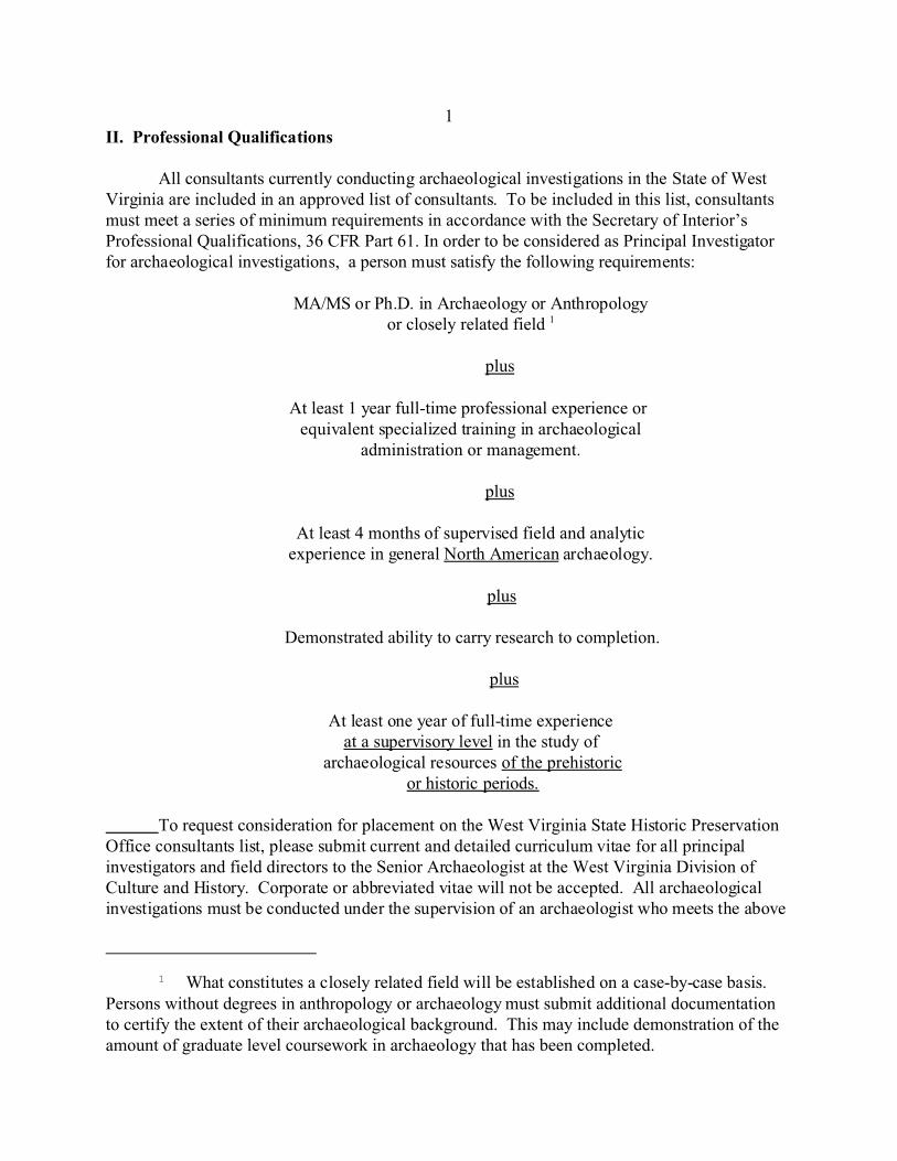
1 What constitutes a closely related field will be established on a case-by-case basis.Persons without degrees in anthropology or archaeology must submit additional documentationto certify the extent of their archaeological background. This may include demonstration of theamount of graduate level coursework in archaeology that has been completed.
1II. Professional Qualifications
All consultants currently conducting archaeological investigations in the State of WestVirginia are included in an approved list of consultants. To be included in this list, consultantsmust meet a series of minimum requirements in accordance with the Secretary of Interior’sProfessional Qualifications, 36 CFR Part 61. In order to be considered as Principal Investigatorfor archaeological investigations, a person must satisfy the following requirements:
MA/MS or Ph.D. in Archaeology or Anthropology or closely related field 1
plus
At least 1 year full-time professional experience or equivalent specialized training in archaeological
administration or management.
plus
At least 4 months of supervised field and analytic experience in general North American archaeology.
plus
Demonstrated ability to carry research to completion.
plus
At least one year of full-time experience at a supervisory level in the study of
archaeological resources of the prehistoric or historic periods.
To request consideration for placement on the West Virginia State Historic PreservationOffice consultants list, please submit current and detailed curriculum vitae for all principalinvestigators and field directors to the Senior Archaeologist at the West Virginia Division ofCulture and History. Corporate or abbreviated vitae will not be accepted. All archaeologicalinvestigations must be conducted under the supervision of an archaeologist who meets the above
qualifications.
2III. Archaeological Site File Searches
As of August 1, 1996, all consultants conducting archaeological investigations in reviewand compliance-related cultural resource inventory projects must conduct a literature review andsite file search prior to initiating fieldwork. In the event of emergency situations, the conduct ofa literature review prior to fieldwork may be waived. The consultant must still conduct theliterature review after completion of fieldwork. The consultant must also bear in mind thatadditional archaeological investigations may be necessary following the literature review.
Literature reviews and site file searches must be conducted at the West Virginia Divisionof Culture and History/State Historic Preservation Office, located in the Cultural Center inCharleston, West Virginia. Consultants must contact the Survey Archaeologist and/or NationalRegister Survey Coordinator at least 48 hours before scheduling a file search. This is necessaryto ensure that appropriate WVSHPO staff are available to assist consultants. Office hours areMonday through Friday, 9 am to 12 pm and 1 pm to 4:30 pm. Walk-ins will not be permittedaccess to the files. The office is closed between 12 and 1 pm for lunch. There will be noexceptions.
All documents and site files must be removed and returned to the shelves by SHPO staff. Consultants will not be allowed access to these materials unless SHPO personnel are present. Documents may be copied upon approval of SHPO staff at a cost of $0.25 per page. Copies willbe free of charge to representatives of state and federal agencies, Historic LandmarkCommissions, and Certified Local Governments.
In accordance with the Memorandum of Understanding between the West VirginiaSHPO and the United States Forest Service - Monongahela National Forest, all consultantsrequesting information concerning archaeological sites on the National Forest property mustcontact the Forest Service Archaeologist in Elkins, West Virginia at 304/636-1800. Thisinformation will not be made available by the WVSHPO.
In order to monitor literature reviews and file searches, the WVSHPO has developed a form (see Appendix G) that must be filed with all technical reports generated for projects incompliance with Section 106 of NHPA. All file search requests will be assigned the individualWVSHPO File Reference (FR) number, if known. This form must be submitted by the PrincipalInvestigator of each project as an appendix to each technical report. Failure to conduct theliterature review and site file search, or to submit the form, will result in the rejection of theproject report.
3IV. Section 106 and Cultural Resource Investigations
Cultural Resource Investigations are conducted in stages commonly referred to as PhaseI, II and III. A discussion of each phase follows.
Phase I Investigation
Phase I investigation consists of a combination of background research and fieldworkdesigned to identify resources and define site boundaries within a given project area or Area ofPotential Effect (APE). During the Phase I investigation, the entirety of the project area must bestudied. Locations not surveyed or only partially examined during a Phase I investigation willrequire additional work. For extensive projects, such as reservoirs or highway corridors, asampling strategy (i.e. predictive model) may be employed at this stage only after consultationwith the WVSHPO staff and with WVSHPO approval.
Phase I fieldwork consists of a number of methods including pedestrian survey,excavation of shovel test probes, remote sensing, and deep testing of appropriate landscapes. The use of specific field methods and techniques is dependent upon the type of ground coverpresent, the topographic setting, and the amount of observed disturbance in a given situation.
Phase II Investigation
Phase II archaeological investigation is conducted in order to test or evaluate anarchaeological site's eligibility for inclusion in the National Register of Historic Places (NRHP). In order to facilitate the evaluation process, specific information should be recovered during aPhase II investigation. This information may include, but is not limited to: evaluating areas ofmoderate and high artifact densities, determining the vertical limits of the site, the presence ofintact, sub-surface, and/or stratified deposits, site structure, and site formation processes. One ofthe more traditional and standard means of recovering this information is through the excavationof test units.
Following the completion of Phase II investigations, a consultant should be able to makea Determination of Eligibility (DOE) for all resources evaluated. The Criteria for Evaluation areoutlined in the Department of Interior's regulations, 36 CFR Part 60: "National Register ofHistoric Places". Specific references to Criteria for Evaluation are found in 36 CFR 60.4.Additionally, the National Park Service has a series of publications regarding the evaluation ofparticular cultural resources, including archaeological sites, historic mining properties, andcemeteries (see Appendix A). Consultants should be aware that the determination of eligibilitymust also take into account “data gaps”, or lapses in our understanding of area history andprehistory.
Phase II investigations consist of additional background research and fieldwork. Prior tothe initiation of fieldwork, a detailed and concise scope of work must be submitted to WVSHPOfor approval. The Phase II scope of work may be submitted as an appendix or addendum to thecompleted Phase I technical report. If, during the course of fieldwork, Phase II methods are
4found to be inadequate, the scope of work may be modified upon consultation with WVSHPOstaff. In order to facilitate a DOE for an archaeological site, a member of WVSHPO staff mayconduct an on-site evaluation to consult with the project sponsor and archaeological consultant.
Field investigations at the Phase II level are conducted to determine the horizontal andvertical limits of an archaeological site, and to retrieve spatial, temporal, and subsistenceinformation about the site. Field investigations should be designed to retrieve the informationnecessary to determine the eligibility of a site without seriously impacting the contextualintegrity of the resource. Therefore, a limited testing regimen should be developed uponconsultation with the WVSHPO staff.
A number of field methods and techniques may be implemented during Phase IIinvestigations. These include systematic, controlled surface collection, additional shovel tests,mechanical augering, hand-excavated test units, deep testing, mechanical removal of theplowzone, and use of remote sensing techniques.
Phase III Investigation
Once an archaeological site is determined to be eligible for inclusion in the NationalRegister, the effect a project may have on the property must be assessed. Avoidance of theproperty results in a determination of no effect. If the property cannot be avoided, and if anydamage or disruption of the resource will result from implementation of the project, a determination of adverse effect is made. Phase III investigation, also known as data recovery, isone response to such a determination. Data recovery efforts are undertaken to mitigate the adverse effect by recovering significant data or information prior to disturbance or destruction.
When Phase III investigations are necessary, the lead federal agency must submit adetailed data recovery plan to the WVSHPO for review and comment. If the Phase III is to beundertaken in completion of Section 106 responsibilities, the Advisory Council on HistoricPreservation (ACHP) must also be contacted. Briefly, the data recovery plan must include anoverview of previous investigations that were conducted for the archaeological resource(s). Thedata recovery plan must include a brief description of the Phase II finding and justification forthe determination of eligibility, and should guide the level and effort of fieldwork to beconducted.
A number of field methods and techniques may be implemented during Phase IIIinvestigations, including hand excavated test units, deep testing, and mechanical removal of theplowzone and other sediments.
5V. Background Research
Background research is a necessary component to fieldwork and allows the researcher toform a basic understanding of the environmental, geological and cultural history of the regionand project area. Preliminary background searches also serve as the basis for developingarchaeological and historical contexts for the region under study. A thorough knowledge ofpreviously recorded cultural resources and environmental characteristics of a region or projectarea allows the researcher to formulate predictions for the types of archaeological sites thatmight be encountered during fieldwork. Through a synthesis of this information, strategies forconducting fieldwork may be developed and implemented.
Background research must be conducted prior to the initiation of any fieldwork for thisto be successful. Documents available at the WVSHPO include United States Geological Survey(USGS) quadrangle maps containing the location of known archaeological sites and previouslysurveyed project areas, and corresponding archaeological site form files. WVSHPO alsomaintains a library of cultural resource management technical reports produced for Section 106projects conducted in the state, as well as county-wide historical survey files, National RegisterFiles and Coal Heritage Survey files. There are a number of other research facilities available foruse including the West Virginia State Archives in Charleston, the Institute for the History ofTechnology and Industrial Archaeology and the Geological and Economic Survey at WestVirginia University in Morgantown, and the Eastern Coal Fields Archives in Bluefield. The WestVirginia Archeological Society maintains a substantial collection of documents at the SouthCharleston Library as well. Researchers should contact local historical societies, libraries andcourthouses for project-specific information, and should examine artifact collections heldprivately or in museums when possible.
Prior to initiating Phase II fieldwork, the consultant must conduct additional backgroundresearch concerning the environmental, archaeological and historical background of the region. The consultant should conduct limited, comparative research on a regional level to identifypotential data gaps in the area. A research design should be developed to serve as a guide tofieldwork. The research design should formulate specific questions to be addressed duringfieldwork. Research questions should facilitate the determination of eligibility for the resource.
During Phase III investigations, the background research should be inclusive andconcentrate on those aspects stipulated in the research design. For historic sites, the backgroundresearch should include extensive document searches from such sources as local histories, deeds, diaries, correspondence, and journals. Again, the research design should formulate specificquestions that can be addressed during fieldwork. Potential research questions may include, but
are not limited to, the following:
! How does the site fit into known regional settlement patterns?! How did its inhabitants exploit locally available plant, animal and mineral
resources? ! What resources were available? ! What are the temporal and/or cultural affiliations of the site?! What is the research potential of this site?
6VI. Field Methods
Pedestrian Survey
A pedestrian survey is conducted over the entirety of the project area in order todetermine the locations of above-ground resources (i.e. cemeteries, rockshelters, petroglyphs,pictographs, earthworks and foundation remnants) and to determine the nature of physical andenvironmental aspects of the project area. This method is most useful in situations where slopesexceed 20%. Pedestrian survey transects shall be spaced at 10-15m intervals to ensure properground surveillance. As survey is conducted, photographs of the survey area should be taken,and any above ground resources should be mapped.
Plow Stripping
In project areas which have been previously cultivated, plow-stripping may be used incombination with shovel test probes. Plow-strips should be at least 2m wide and be placed at15m intervals across the entirety of the project area.
Controlled Surface Collection
A systematic, controlled surface collection may be conducted in areas with surfacevisibility greater than 75% (100% visibility is preferred). Areas which have been previouslycultivated may be disked and/or plowed to create greater surface exposure.
The controlled surface collection should be conducted within a metric, grid-coordinatesystem superimposed upon the area to be evaluated. Collection units may be 1x1 m, 2x2 m or5x5 m on a side, but one unit size must be used consistently. All collection units and artifactconcentrations must be placed on a map accompanying the technical report. Alternatively, theinvestigator may map the x, y and z coordinates for diagnostic and other artifact classes, andmap artifact concentrations using a total station theodolite or other surveying instrument.
Surface collection should be conducted to define the horizontal limits of a site, toincrease the sample size of artifacts (particularly temporally diagnostic artifacts) and to facilitatethe identification of moderate and high artifact densities across the site. The identification ofthese areas should guide the placement of hand-excavated units.
Shovel Test Probes
When ground cover exceeds 25%, shovel test probes (STPs), must be used to locatecultural resources. Shovel tests are used to define areas of low, moderate and high artifactdensities in order to guide the placement of excavation units. At a minimum, shovel testtransects should:
a). adequately cover project corridors (e.g. follow a project centerline and both right-of-way limits for corridors); and
7b). be placed systematically on a metric grid or in transects on land parcels.
Shovel test transects should be placed at 10-15 m intervals over the entirety of the projectarea. Shovel test pits must be a minimum of .50 x .50 m in diameter and excavated into subsoilor at least 10 cm into archaeologically sterile sediments. All excavated soils must be passedthrough 1/4-inch mesh hardware cloth. Representative profiles and/or photographs of STPs,including Munsell descriptions, must be included in technical reports.
If an archaeological site is identified, a detailed plan map indicating the location of bothpositive and negative shovel test probes must accompany the report. For surveys with largeAPEs, the map should indicate locations where shovel testing occurred. These areas may beoutlined with cross-hatching.
When slope gradients exceed 20%, the ground surface is flooded or waterlogged, orlandscapes are extensively altered or disturbed, STPs will not be necessary. All areas not shoveltested must be fully documented by photographs and indicated on maps in the technical report.
When a positive STP occurs, subsequent shovel tests must be placed at 5 m intervals inall cardinal directions (radials) until two negative shovel tests in a row are encountered. Testingof positive radials is not necessary if site boundaries have been adequately defined through othermethods.
When historic structures greater than 50 years of age are encountered, shovel tests mustbe placed around the perimeter of each structure in order to determine if historic archaeologicaldeposits are present.
A distinction should be made between a rock overhang and rockshelter. A rockoverhang is used to define absence of human occupation, while the term “rockshelter” is usedwhen evidence of human occupation is identified. When rock overhangs are encountered duringpedestrian survey, the floor should be inspected to determine the presence/absence of culturalmaterials. If cultural material is not evident on the floor, then a shovel test probe must beexcavated to determine the presence of cultural materials.
Remote-Sensing Techniques
Remote-sensing techniques are non-invasive means of identifying archaeological sites. They may include (but are not limited to) aerial photography, metal-detecting, magnetometry,electrical resistivity, electromagnetic conductivity surveying, and ground-penetrating radar.
False-color infrared aerial photographs have been used to detect village patterns,earthworks, foundation remnants and mounds. The use of metal detectors has also beensuccessful in identifying and examining archaeological sites, particulary historic and militarysites. The use of a metal detector or any other remote sensing technique should supplementrather than replace shovel testing, and must be coordinated with WVSHPO staff.
8The implementation of remote-sensing methods should be conducted by persons versed
in their use and interpretation. Not every project area and/or site has the potential to produceresults worth the expenditure of time and funding to conduct remote sensing. Consult withWVSHPO staff prior to implementing any such methods.
Deep Testing
Deep testing is often necessary to determine if certain landscapes or topographic settingscontain deeply buried archaeological deposits. Deep testing is also used to determine if deeplyburied cultural deposits exist and to collect information on site structure and site formationprocesses. Appropriate landscapes include but are not limited to flood plains, terraces, andcolluvial/alluvial fans.
During Phase I and II investigations, deep testing is conducted to determine thepresence, absence, and nature of buried archaeological deposits. A variety of deep testingmethods and techniques may be used, including backhoe trenching, hand-augering, truck-mounted borings to remove intact soil cores, and the examination of cut-bank profiles. Themethods used depend upon the topographic setting, the size of the project area, and consultationwith WVSHPO staff. Representative photographs and soil profiles, as well as detailedillustrations and descriptions of soil strata and composition, must be included in the technicalreport for any method chosen. Deep testing methods are used to supplement archaeologicalinvestigations, and are not a substitute for STPs or test units. The WVSHPO staff recommendsthat a professional geomorphologist be consulted during Phase II investigation to develop ageomorphological history and to define site formation processes within the project area. Thisinformation must be included in the final report.
The number and placement of backhoe trenches is dependent upon the landscape andshould be determined in consultation with WVSHPO staff. Backhoe trenches should beexcavated until Pleistocene or channel lag deposits are reached, if possible. Trenches should beexcavated in such a way that soil strata may be examined, profiled, recorded, photographed andsampled safely. A complete and detailed profile of any trench must be included in the technicalreport, including the depth, length, and width of the trench. Additionally, the location of eachbackhoe trench must be mapped and included in the technical report. Photographs of profiles
must be taken with a photo board and vertical scale. The ground surface of the trench must beclearly visible in the photograph. It is the consultant’s responsibility to ensure that all deeptesting is performed in compliance with OSHA standards while attaining the necessary soils andresource information.
In order to correlate cultural and geomorphological data on landform and site formationprocesses, a .50 x .50 m test unit must be excavated along one wall of each backhoe trench. Units must be excavated in 10 cm arbitrary levels within artificial or natural soil strata. Allexcavated soils must be passed through a 1/4-inch mesh hardware cloth. Test units are notnecessary for each backhoe trench, if soil columns are also being gathered.
9During Phase III investigations, deep testing is often conducted to facilitate and guide
data recovery efforts. Identification of archaeological and geological strata in backhoe trenchescan coordinate excavations of deeply buried deposits. Understanding the geomorphologicaldevelopment of the area is as significant as understanding the cultural development of the site.Again, the WVSHPO staff recommends that a professional geomorphologist be consulted.
Excavation Units
Phase II Investigations
During a Phase II investigation, the placement of excavation units should be based ondata gathered during the Phase I. Excavation units should also be placed so that the optimumamount of information is gathered without destroying the integrity of the site. Excavation unitsshould be placed within a grid-coordinate system to ensure continuity. Units must be hand-excavated and at least 1x1 m on a side. Units may also be 1x2 m, or 2x2 m, but the unit size thatis selected must be used consistently. Hand-excavated units should be excavated in 10 cmarbitrary levels within cultural or natural soil stratigraphy. In situations where soil strata arecompacted or difficult to discern, an investigator may also use 5 cm arbitrary levels. All unitsmust be excavated at least two levels (20 cm) below cultural deposits. All excavated sedimentsmust be passed through 1/4-inch mesh hardware cloth. Two contiguous walls of each test unitmust be troweled, profiled and photographed.
If cultural features or stratified cultural deposits are encountered during testing, anappropriate sampling strategy must be used. A detailed discussion concerning featureexcavation and sampling strategies is found in the sections on Feature Identification andSampling Procedures.
Test units placed near standing structures or foundation remnants may be excavated inthe English System of measurement in accordance with current and acceptable historicarchaeological excavation techniques. If structures and foundations are not evident, however,excavations should follow metric excavation techniques.
When rockshelters are evaluated, excavation strategy should take into consideration thetypes of site formation processes that developed these resources. Rockshelters represent adelicate and fragile archaeological resource, and contain sensitive environmental information. Because of the nature of deposition found in rockshelters, cultural deposits may be quiteshallow, and may contain multiple occupation levels. The number and placement of test unitswithin a rockshelter is dependent upon the size of the shelter to be tested. If possible,rockshelter deposits should be excavated in 5 cm arbitrary levels within cultural or naturallydeposited sediments. If 5 cm levels are not possible, the investigator may wish to increasevertical control by obtaining x, y and z coordinates for diagnostic artifacts. If activity loci aredefined, this method of vertical control may be used for other artifact classes. All soils shouldbe passed through hardware cloth with mesh no larger than 1/4-inch, although mesh as fine as1/8-inch may be used if necessary. At least one test unit should be placed outside the drip line ofthe shelter. Appropriate excavation of features and sampling strategies should follow thoseoutlined below.
10Phase III Investigations
During Phase III investigation, test units should be placed in order to optimize datarecovery. Phase II investigations and the data recovery plan should guide the placement of testunits at the site. For example, the use of block excavations may facilitate access to deeplyburied archaeological deposits. Test units should be used where the use of heavy machinery (such asbelly pan scrapers) would negatively impact archaeological deposits. The data recovery effortshould include testing of both high and low density areas.
Mechanical Removal of Plowzone and Other Sediments
The mechanical removal of plowzone may be implemented only upon consultation andwith the approval of WVSHPO staff, and should be stipulated in any scope of work or datarecovery plan. Plowzone removal may be conducted in areas that were subject to previouscultivation practices and that exhibit a definable plowzone.
Plowzone removal may be used in previously cultivated areas to facilitate theidentification of subsurface features. The degree of plowzone removal shall be determined bythe intensity of the investigation effort. Plowzone removal during Phase II investigation shouldbe as non-invasive as possible in order to protect the integrity of the site. Removal during datarecovery efforts may be as extensive as necessary to identify subsurface features. It is alsoacceptable to mechanically remove sediments in order to reach buried archaeological deposits, ifburied deposits are known to be overlain by culturally sterile soils (i.e. fill).
Phase II Investigations
Following the removal of plowzone, the area should be shovel-scraped or trowel-scrapedto expose a clean surface for inspection and identification of subsurface features. A detailed
discussion on feature excavation and sampling strategies is found in the sections titled FeatureIdentification and Sampling Procedures.
Phase III Investigation
The mechanical removal of the plowzone may be implemented during Phase IIIinvestigations in areas that were subject to previous cultivation practices and that exhibit adefinable plowzone. During Phase III investigations, plowzone removal may be conducted toexpose large, contiguous areas of the surface in order to identify sub-plowzone features.
Feature Identification
Once a subsurface feature has been identified (e.g. postmold, hearth, storage/trash pit,etc.), its location must be mapped according to the site grid-coordinate system. Each featuremust be mapped in planview and photographed. Once the planview has been drawn, one-half of the feature must be excavated in order to determine its content and stratigraphic profile. Features may be excavated in halves or quarters along its long axis. If internal stratigraphy isevident,
11features should be excavated in 5-10 cm levels within stratified deposits or depositionalepisodes. One-half of each feature must be profiled and photographed. All profiles should havea north arrow, scale and key. Once the feature has been completely excavated, the basin shouldbe photographed. All photographs should be taken with a photo board, vertical scale and northarrow.
Sampling Procedures
During the course of Phase II and III excavations, appropriate samples must be taken toaid the investigator in gathering as much information about the archaeological site as possible. Samples gathered from test units and features should be removed below the plowzone level toreduce the risk of contamination. It is especially important to collect samples from enclosedenvironments such as rockshelters, the interiors of containers and vessels, and burials.
Collected samples should include charcoal (for radiocarbon dating and speciesidentification), flotation, phytolith, pollen, and soil. Flotation samples should be at least 5-10liters in size and taken from each level below plowzone. Flotation samples gathered fromfeatures may be up to15 liters per excavated half, or the half itself may be taken for a flotationsample. If internal stratigraphy is evident within feature fill, then a flotation sample should beremoved from each stratified deposit. The types of samples to be gathered depend upon anumber of factors including preservation, funding and processing capabilities. Most samplesmust be processed and analyzed by specialists.
Recovery Methods
The methods of recovering archaeological materials should be guided by the Phase IIworkplan or the data recovery plan. Methodology becomes particularly important whenattempting to retrieve information on subsistence or settlement patterns. For example, dry andwet screening methods are both acceptable. Wet-screening, however, is less destructive tobotanical and faunal materials. The technique chosen also depends upon soil types andconditions. All excavated soils should be screened through 1/4-inch mesh hardware cloth,although1/8-inch and 1/16-inch mesh hardware cloth is also acceptable if smaller artifacts orecofacts are expected to be recovered.
12VII. Recordation and Documentation of Archaeological Sites
An archaeological site may be defined as a locus of human activity that is manifested bythe presence of artifacts. Examples of archaeological sites include isolated finds, petroglyphs,pictographs, rockshelters, village sites, cemeteries, prehistoric earthworks and mounds, historicearthworks and fortifications, farmsteads, industrial sites, foundations, and ephemeral scatters ofprehistoric and historic debris.
When an archaeological site is identified, additional steps are necessary to determine itshorizontal boundaries. During a pedestrian survey, site boundaries can be defined by reducingsurvey intervals between observation points (in a plowed field) or by implementing shovel testprobes (in wooded or grassy areas). If a previously recorded site is known to be within an area itmust be relocated and re-identified.
Proper recordation and documentation of historic or prehistoric archaeological sitesrequires representative photographs and/or profiles of STPs, and the placement of STPs on thesite map. Representative photographs of identified sites must also accompany each site formand technical report.
A West Virginia Archaeological Site Form (see Appendix H) must be prepared for eachidentified site. A revised archaeological site form must be prepared for each relocated and re-identified site. A West Virginia Isolated Find Site Form (see Appendix I) must be completed foreach isolated find, defined as a single artifact find. A West Virginia Cemetery Survey Form (see
Appendix J) must be prepared for each identified cemetery. If standing structures are identifiedwithin the boundaries of the project area, then a West Virginia Historic Property Form must becompleted (see Appendix K).
Completed West Virginia Archaeological Site forms must include the following: adetailed site plan or sketch map (must include location of STPs), a USGS quadrangle map withsite location noted, and representative photographs of the site. The USGS map must include anorth arrow, scale, quad name, year and contour interval. Site sketch maps must include a northarrow and scale. The form should also include a discussion of artifact densities or percentagesnoted, as well as a discussion of all diagnostic artifacts recovered. If structural or foundationremnants are identified, a site plan or sketch map of each foundation must be included. Twocopies of each site form must be submitted separately, one for the permanent site records andone as an appendix to the technical report. Site forms must be printed on acid-free paper. Incomplete forms will be returned for revision.
Permanent, trinomial site numbers will be assigned upon receipt of the originalarchaeological site form. Facsimile transmission of site forms is not acceptable. As stated inWVSHPO June 25, 1994 and March 23, 1998 letters, site numbers will not be assigned over thetelephone. Archaeological site numbers will be assigned within three working days upon receiptof the form. Site numbers are not necessary for report submission.
13If a previously unrecorded site is identified during Phase II investigations, a West
Virginia Archaeological Site Form must be prepared. An amended and revised archaeologicalsite form should also be prepared for each site in which Phase II investigations have beencompleted. The form should include information concerning site size, archaeologicalcomponents present, diagnostic artifacts recovered, and artifact density. The form should alsoinclude a map indicating the location of investigations and site boundaries.
14VIII. Inclusion of West Virginia Historic Property Inventory Forms
When historic buildings or structures are located within the area of potential effect orproject area, no archaeological report is complete without their identification and evaluation. Although report text may include a description of the resources, the West Virginia HistoricProperty Inventory Form (see Appendix K) must be completed. Original forms must besubmitted separately, and copies may be included in the bound report. If Phase I archaeologicalresults dictate additional research at the Phase II level, evaluation of the standing structure(s)according to National Register Criteria may be postponed until that time. If not, full evaluationof the structure(s) must be submitted with the completed Phase I report. Full evaluationincludes, at minimum, the following:
1. Historic Context: an explanation of the relationship of the resource to its setting and historic use. Include dates within which the property was in use;
2. Deed Research: identification of date of construction and property ownership;
3. Oral History: information obtained from local informants regarding ownership, use and significance of the property;
4. Brief Description: information regarding the appearance of the structure and materials used in its construction; and
5. Statement of Significance: in relation to National Register Criteria.
The WV SHPO relies upon National Register (NR) Bulletins for further guidanceregarding application of the Criteria of Eligibility. Notable among these are NR Bulletin No. 15“How to Apply the National Register Criteria for Evaluation”, NR Bulletin No. 24 “Guidelinesfor Local Survey: A Basis for Preservation Planning”, and NR Bulletin No. 21 “DefiningBoundaries for National Register Properties.” The WV SHPO encourages early consultationregarding historic properties, and can provide further guidance upon request.
15IX. Recommendations
Phase I Investigation
If data generated during a Phase I investigation clearly document the absence of culturalresources, or if identified cultural resources do not meet the criteria for eligibility to the NationalRegister of Historic Places, then a recommendation of no additional work is appropriate. WVSHPO staff will provide additional recommendations to the lead agency regarding theeligibility of the resource and whether additional investigations are necessary.
In order to reach this conclusion, reasons for the determination of ineligibility must beclearly stated. For example, an isolated find usually does not meet the minimum Criteria forinclusion in the National Register and will require no additional investigation. The recordationand documentation of such a site exhausts its research potential, therefore the project will haveno effect on the site.
If the research potential for a particular site has not been exhausted at the Phase I level,further archaeological investigations may be necessary. A number of factors and questions may
be considered at this point, including site integrity, presence/absence of intact stratigraphicdeposits, subsurface features and/or ecofactual materials, site location, and topographic setting.
If the eligibility of an archaeological resource cannot be determined upon completion ofPhase I investigations, then avoidance or Phase II testing may be recommended. If avoidance isnot a viable option, then Phase II investigations must proceed.
Phase II Investigation
At the close of Phase II investigation, the investigator must provide recommendationsregarding the eligibility of the resource(s) for inclusion in the National Register of HistoricPlaces. Following these recommendations, the federal agency responsible for the undertaking,in consultation with the WVSHPO, makes a final determination of eligibility. If the WVSHPOdisagrees with the report's recommendations, or determines that the report is incomplete orinsufficient, further Phase II investigations may be required in order to make an accuratedetermination.
If the resource is recommended to be not eligible for inclusion in the National Register ofHistoric Places, and the consulting parties concur, then no further archaeological investigationsare considered necessary. Monitoring during construction activities may be recommended toensure that a qualified archaeologist is on site in the event that archaeological deposits orfeatures are discovered.
If the resource is recommended as eligible to the National Register and the consultingparties concur, the agency responsible must determine what effect the undertaking will have onthe resource. In accordance with 36 CFR 800.5, the responsible agency must apply the Criteriaof Effect. Once a resource has been determined to be eligible, two options may be exercised:
16
1). Avoidance or 2). Mitigation
If a resource can be avoided, then the undertaking will have no effect on the NationalRegister eligibility of the resource (36 CFR 800.4(d) as defined in 800.16(i)). If avoidance ispossible, stipulations must be established to ensure that the resource will not be harmed. Avoidance measures may require fencing or monitoring activities.
If avoidance is not an option, then the undertaking will have an adverse effect on theresource in accordance with 36 CFR 800.5(a)(1). A finding of adverse effect requires resolutionunder 36 CFR 800.6, including involvement of consulting parties and the Advisory Council onHistoric Preservation. Consultation results in the development of a Memorandum of Agreementoutlining the methods to be used in the resolution of the adverse effect.
Phase III data recovery is usually recommended in response to a determination of adverseeffect. Once data recovery efforts have been recommended as a mitigative response, a detaileddata recovery plan must be submitted for review and comment to the WVSHPO and theAdvisory Council on Historic Preservation. The WVSHPO will respond with written commentswithin thirty days of receipt of the data recovery plan.
17X. Determination of Eligibility
A number of factors must be considered in order to make eligibility recommendations. The investigator must be able to answer the following questions: Does the data recoveredanswer research questions posed in the scope of work? More importantly, does the site have thepotential to address research questions not answered?
The quality of significance is of paramount importance in any determination of eligibilityfor inclusion in the National Register. There are four Criteria of Eligibility, and a resource mustmeet at least one of these to be considered eligible (NR Bulletin No. 15). Briefly, these Criteriaare:
A. Association with events that have made significant contributions to broad patterns

of history;B. Association with the lives of persons significant to our past;C. Embodiment of distinctive and significant characteristics of a type, period or method
of construction; D. Having yielded, or having the potential to yield, significant information important to prehistory or history.
Archaeological sites are most often determined eligible under Criterion D, but may qualify underany or all of the Criteria above. For instance, a Civil War battlefield site may be eligible underCriterion A for its association with a pivotal conflict. Archaeological properties may also beclassified as individual sites or as historic or prehistoric districts (NR Bulletin No. 36). It isimportant to keep the overall context of the site in mind when presenting a determination ofeligibility.
There are several variables to consider when making recommendations concerning theeligibility of an archaeological site. These include the following:
1). Integrity 2). Site Type 3). Temporal and Cultural Affiliation
Archaeological sites are complex and the variables noted above are interrelated.Generally, an archaeological site is not considered eligible on the merits of one variable alone. In addition to these variables, the researcher should be familiar with the literature covering thearea under study. This includes a familiarity with the so-called "gray literature" found inpreservation offices and universities. A discussion of each variable follows.
A. Integrity - The integrity of an archaeological site is one of the most important variables toconsider when determining the eligibility of a resource. Integrity refers to the level ofsite preservation as well as to the quality of information recovered from that site. The sitemust possess relatively intact deposits, even if such deposits lie beneath a plowzone or
18other surface disturbance. As well, the site must provide spatially, temporally, andfunctionally diagnostic information (NR Bulletin No. 36).
B. Site Type - The type of site under investigation also contributes to the eligibility of aresource. It is important to consider the data that may be retrieved from a site and howthat information may contribute to the understanding of similar site types in the state.Sites that address “data gaps”, or areas where little or no documented archaeologicalresearch exists, are also potentially eligible. For example, little is known about historicgrist mills in the western portion of the state, any information that can be gathered fromsuch a site will contribute significantly to our knowledge of the archaeological record.
C. Temporal or Cultural Affiliation - The age or temporal affiliation of a site is anotherimportant factor to consider. Some archaeological investigations have focused on sitesfrom a specific temporal or cultural affiliation, to the exclusion of others. Again, sitesthat address such “data gaps” must be carefully considered.
19
XI. Data Recovery Plan
The data recovery plan must include an overview of previous investigations that wereconducted for the archaeological resource(s) in question. The data recovery plan must include abrief description of the Phase II finding and justification for the determination of NationalRegister eligibility. The plan must also discuss the research potential of the archaeologicalsite(s) under study. The investigator must develop a research design that is tailored to thespecific site type, and formulated to gain optimum information from the archaeological site. The development of research questions or topics may guide the research design. Research
questions may include such topics as placement of the site into regional subsistence andsettlement patterns, or development of data regarding raw material procurement and tradingnetworks.
A detailed discussion of field and laboratory methods should follow the introduction andresearch design. A field methods and technique section should discuss an excavation plan,including the size and number of test units and total square meters to be excavated. This sectionshould indicate whether test units are to be excavated in arbitrary or natural levels, or arbitrarylevels within natural or archaeological strata. It should also include unit level depth, incentimeters for prehistoric sites or inches for historic sites. As well, this section should discussrecovery techniques and what size hardware cloth mesh will be used. If large-scale mechanicalstripping is to occur, the total area of exposure must be determined and included in this section.
The field methods section should also be concerned with the sampling strategy to beused. Because of the time and funding required, it is not always possible to excavate an entiresite. In these instances, the site must be sampled in order to properly mitigate an adverse effect.Phase II investigations should be used to determine areas in which to concentrate data recoveryefforts. This section must include the types of samples to be taken (e.g. radiocarbon, flotation,and soil), how they are to be recovered, and sample size. Methods for identification, excavation,and sampling of features must also be discussed.
A laboratory methods section should discuss the types of analysis to be used and howanalysis is to be conducted. It should also discuss any special methods that may be used (e.g.residue or use-wear analysis, etc.). The data recovery plan should also contain discussion of theidentification and treatment of human skeletal remains. In accordance with 36 CFR 79:“Curation of Federally Owned and Administered Archeological Collections”, the data recoveryplan must discuss the treatment and disposition of artifactual materials and associateddocuments.
Finally, the data recovery plan must include information about public access to datagenerated by the project. This may consist of setting up public displays or providing copies ofreports to local public libraries, landmark commissions, historical societies or schools. Othermeans may include public lectures, videos, web sites, or traveling exhibits. The manner inwhich public access is provided should be developed in consultation with the sponsor andWVSHPO. Any revisions or amendments to the data recovery plan must be reviewed andapproved by the WVSHPO and the ACHP prior to commencement of work.
20XII. Report Format
Cultural resource reports for different stages of project development should adequatelyreflect the level of investigation completed. The following format outline is intended to serve asa guide to the types of information that should be included in each report. Certain sections maynot be applicable to Phase I or Phase II investigations. The Society for American Archaeology

style guides should be used in preparing any report. Two copies of the report, one with originalphotographs and on acid-free paper, must be submitted to WVSHPO for review and comment.
During Phase I, II and III investigations, expedient review is often necessary in order toaccommodate various state and federal agency project schedules. To facilitate these reviews,WVSHPO has (on a case by case basis) agreed to accept variations to technical reports,including Management Summaries, Addendum Reports and Letter Reports. For projects whereno cultural resources or isolated finds are identified, Abbreviated Reports are acceptable. Theformats for Management Summaries, Addendum Reports and Abbreviated Reports are foundbelow. The numbers and letters referenced are defined in the Standard Technical ReportFormat.
Management Summaries
In order to expedite the review of a project, Management Summaries are acceptable withthe understanding that a completed Phase I or Phase II report is still required. At the minimum aManagement Summary should include: Title Page Introduction, 3 a-c (Standard Technical Report Format) Environmental Setting, 4 d Field Techniques, 7 Results/Inventory of Resources, 9 a (1,2,4,5,6); and b (1,3,4,5,7) Composite Assemblage, 10 c Recommendations Conclusions References Cited Signed copy of Cultural Resources Files and Library User Registration and Research Record Form
Addendum Reports
If Phase I investigations are an extension or amendment to a previously submitted andreviewed project, an Addendum to the existing report may be prepared in lieu of a standardPhase I report and should include:
Title Page Introduction, 3 a-c Environmental Setting, 4 d Field Techniques, 7
21 Results/Inventory of Resources, 9 a (1,2,4,5,6); and b (1,3,4,5,7) Composite Assemblage, 10 c Recommendations
Conclusions References Cited Signed copy of Cultural Resources Files and Library User Registration and Research Record Form
Abbreviated Technical Reports
If no cultural resources have been identified during a Phase I Investigation, anAbbreviated Technical Report is acceptable for submission and must include:
Title Page Introduction, 3 a-c Environmental Setting, 4 c-d Field Techniques, 7 a-c, and h Results 9 a (1-5) Recommendations Conclusions References Cited Signed copy of Cultural Resources Files and Library User Registration and Research Record Form
Standard Technical Report (Phase I, II and III Investigations)
1. Title Page: a. Title of report including name and location of project;
b Author(s);
c. Principal Investigator(s), affiliation, address, phone number and signature (mandatory);
d. Name, address and phone number of client;
e. Lead state/federal agency and contract/permit number(s);
f. Date of report; and
g. WVSHPO-assigned FR number, if known (should be placed in upper right hand corner of report to facilitate tracking).
22
2. Abstract/Management Summary: Should not exceed two pages, and should include: a. Brief description of the project and purpose of investigation; and
b. Precise summation of report’s findings, conclusions and recommendations. 3. Introduction: Discuss the purpose of the project, results and possible impacts to archaeological sites, including the following information:
a. Project sponsor, permit/contract numbers and include statutory regulations under which project is being conducted;
b. Detailed description of project area or area of potential effect (APE), specific project location (including county, town, or township), number of acres surveyed, reason for conducting project, how project areas were investigated, and potential impact on cultural resources. Locate the project area geographically on a state or county map, and include the project area on a 7.5' USGS quadrangle. Include thename and date of the USGS map. Construction or project planning maps may also be included. Each map must include a north arrow and key;
c. Dates of the investigation and personnel involved in the project; and
d. Disposition of field notes, artifacts and other materials.
4. Environmental Setting: This should be a detailed description of the project area environment, focusing on its resource utilization potential and factors affecting the preservation of archaeological sites. This should include past and present disturbances within the project area. This section should also discuss the ecological methods and techniques used to model past environments. At a minium the following information should be included:
a. Physiographic province and local features of the landscape, including discussions of drainage, soils, hydrology, geomorphology, and geology;
b. Regional/local Pleistocene and Holocene environmental overview (if appropriate);
c. Modern environmental setting (historic environment and land use patterns, etc); and
d. Current land use pattern in project area.
5. Previous Archaeological Investigations and Background Overview: This section should include a statement that a site file search has been conducted at WVSHPO. An overview of previous archaeological investigations should include the names of investigators, institutions, dates of work, research purposes, methods, and results. A USGS 7.5' map indicating the locations of previously recorded archaeological sites
within a one mile radius must be included. Other information to be included: 23
a. Location and nature of any publications, manuscripts, field notes and collected materials;
b. Informants and their addresses;
c. Listing of all known resources located within a one-mile radius of the project area, including all National Register properties and historic properties within and adjacent to a project area. (All previously identified archaeological sites and historicproperties must be located on the appropriate USGS 7.5' quadrangle map, including the current project area); and d. Concise synopsis of the prehistoric and historic cultural record for the project area and the surrounding region.
6. Research Design: Include a discussion on the expected archaeological potential for the project area and research objectives. This section should focus on the relation of the investigations to state, regional, and national archaeological, architectural and historical studies. Discuss the hypotheses and implications to be tested, including techniques (field and laboratory) used to test implications. Include discussions on the limitations of the research design. 7. Field Techniques: This section should be presented so that reviewers and future researchers may reconstruct what was done and why. Present a detailed discussion and evaluation of field techniques employed, including types of information collected, sampling techniques, artifact retrieval, and provenience recording measures. Include the following information: a. Field maps (should include locations of all areas investigated, including pedestrianand subsurface surveys); b. Surface-survey techniques: Describe and justify in detail techniques used in the project area and on specific sites. Document surface conditions, survey intervals, and collection methods; c. Subsurface techniques: Document shovel test and other subsurface methods used, including STP intervals and dimensions, and recovery methods used; d. Remote-sensing techniques: Describe and evaluate;
e. Test units: Describe test units, discussing size, depth, types of levels used and screen mesh size. Specific information about individual units should be discussed in the
results section;
f. Backhoe trenches: Describe backhoe trenches, methods used, discussing length, width depth and location. Specific information about individual backhoe trenches should be discussed in the results section; 24 g. Features: Describe methods used to excavate features. Specific information about individual features should be discussed in the results section; and
h. Note all constraints on the investigation (e.g. limited access, poor visibility,landowner restrictions and weather conditions).
8. Laboratory Methods and Artifact Curation: This section should involve a detailed discussion of laboratory methods used to analyze and curate artifacts, and should include the following:
a. Describe classificatory or typological schemes used in artifact description and analysis. Give rationale for selection; b. Discuss all metric and non-metric techniques used to process and analyze artifacts and other archaeological materials;
c. Note means of chronological determination for artifact assemblages (e.g. relative or radiometric); d. Describe any specialized samples that were recovered and how they were processed and analyzed (e.g. flotation, radiocarbon, faunal, botanical, pollen, soils, residue analysis, lithics, ceramics or skeletal remains). Discuss size of samplestaken;
and
e. Include information regarding the future location of the curated artifacts and documents.
9. Results/Inventory of Resources:
a. Results: Discuss the results of fieldwork, including surface and subsurface investigations. 1. Maps should include the location of all STPs, auger probes, backhoe trenches, collection blocks, test units and features. All maps must include a north arrow scale, and legend;
2. Representative profiles of STPs, auger probes, backhoe trenches, and test units
must be in the report. All profiles must include a scale and legend;
3. Representative photographs of the project area, excavation unit profiles,feature profiles, and backhoe trenches must be included. Photographs must have a photo board, scale, and legend. Photographs of backhoe trenches must include a vertical scale. All captions must include the direction from which photosare taken. Original photographs, halftones or their equivalents, and high-quality scanned images are acceptable. Black-and-white photos arepreferred, but color are also acceptable; 25 4. Describe the number of STPs, test units, auger probes, and backhoe trenches excavated. Discuss the total area excavated in square meters. If large areas were exposed through plowzone removal, indicate the amount of area in square meters; 5. Describe soils identified in STPs, test units and backhoe trenches, including texture, composition, and Munsell. Include a discussion on geomorphology and site formation processes. Discuss depth or limits of cultural deposits at site; 6. Indicate the depths at which artifacts were encountered within STPs and their overall density across the site; 7. Include planview and profile drawings of identified features with the appropriate scale and legend. Discuss and describe identified feature types (e.g. postmolds, hearths, basin-shaped pits, etc.). Information on length, width, and depth may be presented in table format;
8. Artifact densities per unit and unit level should be presented, as well as distribution of artifact types per unit and unit level. Unit and feature descriptions should include total artifacts and artifact types recovered; 9. Discuss comparisons in the variability between test unit and feature artifact frequencies across the site; and
10. Discuss the occupational history of the site. b. Inventory of Resources: Discuss all of the cultural resources (i.e. archaeological and architectural) identified during the investigation. Clear, concise descriptions of the resource should include:
1. Maps: Include the location of all identified sites on USGS quadrangle. Sketch or site maps should include the location of all positive/negative STPs, as well as foundations, structures, earthworks, and gravestones;
2. Photographs: Include representative photographs of all resources identified;
3. Site number; 4. Site size and boundaries; 5. Site location, including verbal location description and UTM Coordinates;
6. Site setting, including landform, elevation, soils, and nearest water source;
26 7. Discussion and description of artifacts recovered from STPs, surface
collection, test units and backhoe trenches. Discuss the number and types ofartifacts recovered from each site, including the overall artifact density across the site;
and
8. For historic sites include a discussion on archival research conducted for the site. Include chain of title, deeds, manifests and other inventories.
10. Composite Assemblage: This section should present the results of artifact and sample analysis, including:
a. Definitions of analytical units used (e.g. used flake, shatter, biface, projectile point);
b. Metric observations on artifacts recovered (i.e. length, width, thickness, weight, etc);
c. Complete inventory of all artifacts and other materials recovered from field investigations with appropriate provenience information;
d. Photographs and/or drawings of representative artifact types and diagnostic artifacts, including key and scale;
e. Description and discussion of specialized analysis conducted (e.g. faunal and botanical); f. If variable densities are noted (e.g. define activity areas), discuss the variation in artifact types recovered at the site from one area to the next; g. If multiple occupations or components are identified; discuss variability in artifact density and types among and between components; and
h. Discuss intersite variability, comparing the artifact assemblage between site and
similar sites in the region. 11. Evaluation of Research: Discuss and evaluate research goals and questions addressedin the research design, including: a. Data reliability;
b. Relation of analysis to stated goals;
c. Synthesis and comparison of analytical results;
d. Integration of ancillary data;.
27 e. Identification and discussion of the data in terms of regional and local history and prehistory; and
f. Address future research questions.
12. Recommendations: This section must be a concise statement concerning the eligibility of identified resource(s). Information must contain adequate information so that proper management decisions can be made. The following recommendations may be made: A. No cultural resources present - no additional work (Abbreviated Report is acceptable). B. Cultural resources present: 1. Resource is not eligible to the National Register - No Effect determination
2. Eligibility of resource is indeterminable - Phase II testing recommended
3. Resource is considered eligible to the National Register and project will have Adverse Effect:
a. Develop Memorandum of Agreement, stipulating mitigative measures; and b. Develop data recovery plan to be implemented
4. Resource is considered eligible to the National Register and project will have no effect, through: a. Avoidance; or b. Preservation in Place

13. Conclusions: Succinct summation of project, findings, recommendations and effect determination.
14. References Cited/Bibliography: Must conform to the following Society for American Archaeology guidelines: Editorial Policy, Information For Authors, And Style Guide For American Antiquity and Latin American Antiquity, revised August 1996. 15. Appendices
a. Project correspondence;
b. Full reports on ancillary studies (may be placed within main body of report);
c. Artifact inventories;
d. Site forms (must also be submitted separately);. 28 e. Current curriculum vitae of principal investigators and field directors; and
f. Signed copy of Cultural Resources Files and Library User Registration and Research Record Form.
29
Table of Contents
I. Introduction Pg. 1
II. Professional Qualifications Pg. 2
III. Archaeological Site File Searches Pg. 3
IV. Section 106 and Cultural Resource Investigations Pg. 4
V. Background Research Pg. 6
VI. Field Methods Pg. 7
VII. Recordation and Documentation of Archaeological Sites Pg. 13
VIII. Inclusion of West Virginia Historic Property Inventory Form Pg. 15
IX. Recommendation Pg. 16
X. Determination of Eligibility Pg. 18
XI. Data Recovery Plan Pg. 20
XII. Report Format Pg. 21
ii
Appendices
Appendix A: Reference Materials Pg. 30
Appendix B: Excavation and Analysis of Human Skeletal Remains Pg. 33
Appendix C: Treatment of Human Skeletal Remains Pg. 41
Appendix D: Application for Archaeological Excavation Permit Pg. 43
Appendix E: Application for Archaeological Excavation of Pg. 46Unmarked Human Graves
Appendix F: User’s Guide to the Cultural Resource Files Pg. 50
Appendix G: Cultural Resource Files and Library User Registration Pg. 52And Research Record Form
Appendix H: West Virginia Archaeological Site Form Pg. 55
Appendix I: West Virginia Isolated Find Site Form Pg. 61
Appendix J: West Virginia Cemetery Survey Form Pg. 64
Appendix K: Historic Properties Inventory Form Pg. 68
Appendix L: Curatorial Guidelines - Collections Management Pg. 72Facility
* Deed of Gift*Memorandum of Understanding for Curatorial Services
iii
Appendix A - Reference Materials
30
Reference Materials
Laws and Executive Orders:• National Historic Preservation Act of 1966, as amended (P.L. 89-665, 80 Stat. 915)• National Environmental Policy Act of 1969 (P.L. 91-190; 31 Stat. 852)• Archeological and Historic Preservation Act of 1974 (P.L. 93-291; 88 Stat. 174)• Archeological Resources Protection Act of 1979 (P.L. 96-95; 93 Stat. 712)• Native American Graves Protection and Repatriation Act of 1990 (P.L. 101-601; 104
Stat. 3049)
Federal Regulations:• 36 CFR 60 (NHPA): “National Register of Historic Places”• 36 CFR 61 (NHPA): “Procedures for Approved State and Local Government Historic
Preservation Programs”• 36 CFR 63 (NHPA): “Determinations of Eligibility for inclusion in the National Register
of Historic Places”• 36 CFR 68 (NHPA): Secretary of the Interior’s Standards for historic preservation
• 36 CFR 79 (NHPA/ARPA): “Curation of Federally Owned and AdministeredArcheological Collections”
• 36 CFR 800 (NHPA): “Protection of Historic and Cultural Properties”• 43 CFR 3: Antiquities Act of 1906• 43 CFR 7 Subparts A and B (ARPA): “Protection of Archeological Resources, Uniform
Regulations” and “Department of the Interior Supplemental Regulations”• 43 CFR 10 (NAGPRA): Determination of rights to Native American human remains,
associated and unassociated funerary objects, sacred objects, and objects of culturalpatrimony
West Virginia State Code:• 29-1-8: “Historic preservation section; director
Title 82 Series 2: “Standards and Procedures for Administering State Historic Preservation Programs”
• 29-1-8a: “Protection of human skeletal remains, grave artifacts and grave markers; permits for excavation and removal; penalties”Title 83 Series 3: “Standards and Procedures for Granting Permits to Excavate Archaeological Sites and Unmarked Graves”
• 29-1-8b: “Protection of historic and prehistoric sites; penalties”
31
National Register Publications (United States Department of the Interior/National Park Service):• NR Bulletin No. 12: Definition of National Register Boundaries for Archeological
Properties• NR Bulletin No. 15: How to Apply the National Register Criteria for Evaluation• NR Bulletin No. 21: How to Establish Boundaries for National Register Properties• NR Bulletin No. 28: Using the UTM Grid System to Record Historic Sites• NR Bulletin No. 29: Guidelines for Restricting Information About Historic and
Prehistoric Resources• NR Bulletin No. 36: Guidelines for Evaluating and Registering Historical Archaeological
Sites and Districts• NR Bulletin No 40: Guidelines for Identifying, Evaluating, and Registering America’s
Historic Battlefields• NR Bulletin No. 41: Guidelines for Evaluating and Registering Cemeteries and Burial
Places
• NR Bulletin No. 42: Guidelines for Identifying, Evaluating and Registering HistoricMining Properties
Additional References:1993 Henry, Susan L.
Protecting Archeological Sites on Private Lands. United States Department of the Interior, National Park Service, Washington, D.C.
1995 Carnett, Carol L.A Survey of State Statutes Protecting Archeological Resources. National Trust forHistoric Preservation, United States Department of the Interior, National Park Service,Washington, D.C.
1996 Society for American ArchaeologyEditorial Policy, Information for Authors, and Style Guide for American Antiquity andLatin American Antiquity (revised).
1997 National Park Service Cultural Resource Management Guideline. United States Department of the Interior, National Park Service, Washington, D.C.
32

Appendix B - Excavation and Analysis of Human Skeletal Remains
33

Appendix C - Treatment of Human Skeletal Remains
41

Appendix D - Application for Archaeological Excavation Permit
43

Appendix E - Application for Archaeological Excavation ofUnmarked Human Graves
46

Appendix F - Users Guide to the Cultural Resource Files
50

Appendix G - Cultural Resource Files and Library UserRegistration and Research Record Form
52

Appendix H - West Virginia Archaeological Site Form
55

Appendix I - West Virginia Isolated Find Site Form
61

Appendix J - West Virginia Cemetery Survey Form
64
Appendix K - Historic Property Inventory Form
68

Appendix L - Curatorial Guidelines - Collections Management Facility
72


![[REDACTED] FINAL TECHNICAL REPORT, PHASE I (INTENSIVE ... · impacting the site. If avoidance is not feasible, PALrecommendsa Phase III archaeological data recovery program to mitigate](https://img.pdfslide.us/doc/110x75/603cb17f0f2559406913330e/redacted-final-technical-report-phase-i-intensive-impacting-the-site-if.jpg)