Embed Size (px)
Citation preview
1
Guidelines for Owners, Operators and Masters for Protection against Piracy in the
Gulf of Guinea Region
(To be read in conjunction with BMP4)
1. Introduction
Piracy and armed robbery (hereafter referred to as piracy) in the Gulf of Guinea region is an established
criminal activity and is of increasing concern to the maritime sector. With attacks becoming more
widespread and violent, including the increase in kidnapping for ransom, industry has now identified an
urgent need to update these Guidelines. They also now take into account the regionally established
Maritime Trade Information Centre (MTISC).
Although piracy in the Gulf of Guinea region in many ways differs from that of Somalia-based piracy, large
sections of the Best Management Practices already developed by industry to help protect against Somalia-
based piracy are also valid in the Gulf of Guinea region. Consequently, these Guidelines aim to bridge the
gap between the advice currently found in BMP4 and the prevailing situation in the Gulf of Guinea region.
These Guidelines should therefore be read in conjunction with BMP4 and will make reference to BMP4
where relevant.
The Guidelines have been developed by BIMCO, ICS, INTERCARGO and INTERTANKO and are supported by
NATO Shipping Centre. A soft copy of BMP4 can be found on the websites of these organisations.
2. Area for consideration
Pirates in the Gulf of Guinea are flexible in their operations so it is difficult to predict a precise area where a
ship might fall victim to piracy. For the purpose of this guidance the area off the coasts of Ghana, Nigeria,
Togo, Cameroon and Benin can be regarded as an area in which the counter-piracy management practices
should be considered. Attacks and armed robbery have occurred from as far south as Angola and north as
Sierra Leone.
In addition, as of 12 June 2014, the LMA Joint War Committee defines the following “Listed Areas for Hull
War, Piracy, Terrorism and Related Perils” for the Gulf of Guinea:
The territorial waters of Benin, Togo and Nigeria, plus
Nigerian Exclusive Economic Zone north of latitude 3º N, plus
Beninese Exclusive Economic Zones north of latitude 3º N.
Togolese Exclusive Economic Zone north of latitude 3º N.
The LMA Joint War Committee listed areas should be checked regularly for changes.

2
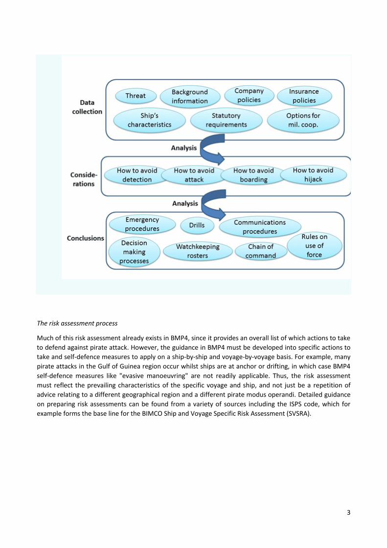
3. Risk Assessment
For the purpose of identifying suitable measures of prevention, mitigation and recovery in case of piracy, a
ship and voyage-specific risk assessment as recommended in Section 3 of BMP4 should be carried out prior
to entering the area described in Section 2 above . Not unlike the Ship Security Assessment described in the
ISPS Code, the risk assessment should include, but may not be limited to, the following:
The threat (who are the pirates, what do they want to achieve, how do they attack, how do they
board, which weapons do they use etc.?)
Background factors shaping the situation (visibility, sea-state, traffic patterns e.g. other commercial
ships, fishermen and human traffickers etc.)
Possibilities for co-operation with military (escorting, employment of Vessel Protection
Detachments, registering with authorities etc.)
The ship’s characteristics/vulnerabilities/inherent capabilities to withstand the threat (freeboard,
speed, general arrangement etc.)
Ship’s procedures (drills, watch rosters, chain of command, decision making processes etc.)
In addition to the information found in this document, supplementary information about the characteristics
of the threat and regional background factors may be sought from, regional reporting centres, Shipping
Association websites, the IMB, commercial intelligence providers or local sources e.g. ships' agents as in the
attached Annex.
As also mentioned in BMP4, the risk assessment should take into consideration any statutory requirements,
in particular those of the flag state and/or the coastal state. Other requirements dictated by company and
insurance policies should also be taken into consideration.
3
The risk assessment process
Much of this risk assessment already exists in BMP4, since it provides an overall list of which actions to take
to defend against pirate attack. However, the guidance in BMP4 must be developed into specific actions to
take and self-defence measures to apply on a ship-by-ship and voyage-by-voyage basis. For example, many
pirate attacks in the Gulf of Guinea region occur whilst ships are at anchor or drifting, in which case BMP4
self-defence measures like "evasive manoeuvring" are not readily applicable. Thus, the risk assessment
must reflect the prevailing characteristics of the specific voyage and ship, and not just be a repetition of
advice relating to a different geographical region and a different pirate modus operandi. Detailed guidance
on preparing risk assessments can be found from a variety of sources including the ISPS code, which for
example forms the base line for the BIMCO Ship and Voyage Specific Risk Assessment (SVSRA).

4
4. Typical Pirate Attacks
Currently, the Gulf of Guinea "pirate business model" is primarily aimed at theft and kidnapping for
ransom.. Generally speaking, pirates in the Gulf of Guinea are more violent than their Somalia based
colleagues. Pirate activity within the Gulf of Guinea can be split broadly into the following categories:
Armed Robbery – In general this is opportunistic, is violent, and occurs where vessels are
approaching, drifting or anchored off ports. There have been instances across the Gulf of Guinea
Region e.g. off Lagos, in Port Harcourt, Bonny River, Cotonou and Lome. For the most part the
intention is to take valuables from the safe, IT equipment, and personal effects.
Cargo theft – This occurs throughout the area described and often occurs in or about the STS
transfer areas where ships are particularly vulnerable. In the main it is related to product and
chemical tankers but there are also regular attacks and thefts on general cargo carriers . Vessels are
hijacked for several days and cargo is transferred to a smaller vessel. These incidents are well-
organised, often involving a criminal element with commercial interests ashore. Recent cargo thefts
have demonstrated that pirates often have a maritime know-how allowing them to disable
communications, operate the cargo system, etc.
Kidnapping – All seafarers are at risk. There have been several instances of offshore supply vessels
and tankers being attacked and seafarers taken ashore for ransom.
Methodology: Pirate attacks in the Gulf of Guinea region often share similar characteristics to those of
Somalia based pirates (see BMP 4 Section 4), but there are some key differences. For example, The main
threat is from approaches made by high-powered speedboats, and a recent incident involved a speedboat
launched from an unidentified mothership.
The risk of falling victim to a pirate attack is particularly high when the ship is at anchor or is drifting off a
port e.g. close to pilot station. Another vulnerable situation is when conducting STS operations and the two
ships are adrift and moored alongside each other.
For the tanker sector, cargo theft results in stolen oil products being sold in the region. For the dry cargo
and other sectors, violent robbery is more common. Attacks, both outside and inside territorial waters,
appear to be the result of intelligence-led planning by the pirates, with particular products such as gasoil or
gasoline being targeted in very well co-ordinated and executed operations. Companies and ships operating
regularly in the region are likely to be at increased risk of falling subject to pirate intelligence collection
operations and subsequent pirate attack.

5
5. Ship Movement Reporting Procedures
Although this may change in future, at present there is no formal, centralised international ship movement
reporting procedure in place in the Gulf of Guinea region. There are however a number of options for
reporting incidents and particularly:
The Maritime Trade Information Sharing Centre Gulf of Guinea (MTISC – GoG):
It is based in Ghana and aims to develop, maintain and share details of the maritime domain picture of the
waters off Africa’s western seaboard. The MTISC-GoG administers a Voluntary Reporting Area (VRA)
scheme under which merchant vessels are encouraged to report position information while operating in
the VRA.
The VRA as shown on Admiralty Chart Q6114, has been issued to clearly define an internationally
recognised area, so ship operators and vessels transiting, trading or operating in West Africa can join a
trusted reporting scheme. The provision of Admiralty Chart Q6114 to all vessels operating in the VRA is
strongly recommended
Position data: suspicious activity and incidents reported to MTISC-GoG by shipping in the VRA, using the
forms on the Chart and repeated at Annex B, assist in the creation of a detailed and accurate regional
maritime domain picture. The analysis is used to produce security recommendations that are shared with
seafarers, ship operators and law enforcement agencies to enhance risk awareness and improve incident
response.
MTISC-GoG: provides a 24-hour manned service of military and industry experts. The MTISC-GoG receives
reports, shares important updates and provides guidance on vessel operating patterns, security risks with
the Gulf of Guinea maritime community.
The MTISC-GoG has no influence over the deployment of military assets to assist merchant vessels
which are attacked, but is linked with national and regional maritime operations centres and may
be able to help direct them to the scene of an incident.
Dedicated staff from regional military authorities and industry collate data from a variety of sources
to aid their understanding of the maritime environment. The voluntary position reports from
vessels operating within the VRA are an important input to greater understanding of maritime
activity - the information reported is used to inform other regional governmental organisations and
inform recommendations to enhance security planning, incident response and investigations.
MTISC-GoG has dedicated experts from the Merchant Navy and INTERPOL to help support this
process
The MTISC – GoG website contains updated guidance and advice in addition to this document, as well as
guidance on the centre's operations. Owners and operators should bring this reporting centre to the
attention of their ships to encourage vessels entering the VRA to report to the centre, make daily reports
during transit and log a departure report when leaving. The contact details and details of the report format
are shown at Annex B.

6
Reporting:
Vessels are encouraged to send regular reports, using the MTISC-GoG reporting forms as below:
WHEN WHAT
On entering the VRA Initial Report
Daily** Daily Position Report
On Departing the VRA Final Report
By Exception By Exception Report
** At 0800 if convenient to daily routine**
How to Report?
The MTISC-GoG reporting forms(see Annex C), should be used to make the reports described above.
Email is the preferred method of communication but alternatively telephone or fax, (see Annex A for
contact details). The MTISC-GoG will respond to all email but cannot respond to reports sent by SAT C.
Regional Maritime Rescue Coordination Centres:
These are established at Monrovia and Lagos and are important points for safety reporting. See Section 13
International Maritime Bureau (IMB):
Ships should report all incidents to the IMB reporting centre in order to accurately reflect the number and
types of incident . See Section 13
There are a number of other reporting centres in the process of being established and it is expected that
the Inter-regional coordination centre in Yaounde will be operational in the second half of 2014.
Individual flag states may well have their own national ship movement reporting procedures. Any flag state
reporting requirements should be clarified and complied with.
The above guidance is the best available at the time of publication, but is likely to change as reporting
centres become operational and regional coordination and cooperation increases. Owners and Operators
should monitor the developing situation in order to ensure that vessels operating in the region are aware of
reporting options available to them. It is essential that each and every incident is reported in order to
maintain pressure on coastal states to meet their obligations under UNCLOS and encourage the
international community to support infrastructure and capacity building in the region.
7
6. Company Planning
The Gulf of Guinea is not subject to an established policing mechanism by international navies, and neither
the UKMTO nor MSCHOA play a role in the region. The NATO Maritime Reporting Centre monitors the
situation but plays no formal part.
Company planning procedures outlined in Section 6 of BMP4 should be applied in the Gulf of Guinea. The
following important advice should be noted:
Communications with external parties should be kept to a minimum, with close attention paid to
organising rendezvous points and waiting positions. For e-mail correspondence to Agents,
Charterers, Chandlers etc. it is strongly recommended that address lists are controlled and that
information within the e-mail is concise, containing the minimum that is legally required in order to
fulfil requirements or contractual obligations.
Contractual arrangements should be put in place with a view to keeping vessels out of harm’s way.
Know your agents and avoid or minimize requirements where possible. Unnecessary interaction
with other parties creates opportunities for information regarding the vessel’s position to be
compromised.
If the ship trades regularly in the region it is recommended to alter arrangements once in a while to
make it harder for criminals to predict where operations might take place.
In terms of the availability of armed escort vessels, the Nigerian Navy are known to offer licences to certain
companies to employ naval personnel on board their escort vessels.
Likewise, some agents and PMSCs offer Nigerian security forces as armed guards for deployment on board
merchant ships. Such services should anyway only be contracted if a requirement exists following the risk
assessment, and only as a supplement to ship protection measures outlined in BMP4.
Using private armed guards in the Gulf of Guinea region is much more problematic than off Somalia, owing
to the complex patchwork of legal, security, administrative, command and control interests that need to be
addressed, and the following should be considered:
Care should be exercised when using private armed guards, as they are prevented by law from
operating inside territorial waters of coastal states in the region, and authorities are known to
enforce these regulations vigorously.
Local or Government forces subcontracted by PMSCs should only be used if they are legitimate,
and trusted (see above). For example it is illegal to use Nigerian Maritime Police beyond the fairway
buoy
7. Master’s Planning
Many of the Master’s planning procedures described in Section 7 of BMP4 also apply to the Gulf of Guinea,
although there are no Group Transit schemes or national convoys. Given the modus operandi of the pirates
operating in the Gulf of Guinea region, the Master should plan according to the following:
Rendezvous - Where possible, avoid waiting and slow steaming. Consider offering several
alternative rendezvous points and advise rendezvous points at the last minute. If waiting, keep well
8
off the coast (up to 200nm). Do not give away waiting positions. Do not drift and keep engines
ready for immediate manuevres.
Anchoring - Where practicable, a prolonged stay at anchorage is to be avoided.
Minimize use of VHF and use e-mail or secure satellite telephone instead. Where possible only
answer known or legitimate callers on the VHF, bearing in mind that imposters are likely and may
even appear in uniform.
The greatest risks of piracy are at night and these need to be factored into all planning. Where
possible, operations should start and end during daylight hours.
8. Ship Protection Measures
The ship protection measures described in Section 8 of BMP4 (except 8.15) also apply in the Gulf of Guinea.
When STS operations are expected to be conducted, extra attention should be paid to the use of physical
protection measures. Although barbed wire can potentially make it very difficult to complete an STS
operation, other protection measures should be considered to protect the ship from attack in these cases.
Vessel hardening is likely to be quite effective in this region and a moving ship also makes an
effective deterrent since, unlike Somalia based pirates, ladders are not often used to board ships.
During STS operations or when adrift, equipment such as fenders, anchor chains and hawse pipes
can potentially provide a vulnerable point of access for attackers, and entry should be physically
blocked.
Pirates detect and target vessels by sight and by the use of AIS. Therefore limit the use of lighting at
night and reduce the power or turn off AIS. Unfortunately, this has a major drawback in that it may
reduce the likelihood of an intervention by "friendly forces" if attacked. Consequently, AIS must be
switched on immediately if the ship is boarded.
The use of citadels is an on owners/master’s choice but it should be borne in mind that their
successful use in the Indian Ocean was predicated upon their being a strong chance of a Naval
Intervention. The principles of their construction and use however remain the same as outlined in
BMP4. Given the levels of violence perpetrated by Pirates, and if control of the engines can be
maintained from the citadel, many think that this option is the safest and also one that prevents
the ship from manoeuvring in order to prevent cargo theft .
Owners should consider the placement of hidden position transmitting devices as one of the first
actions of pirates is to disable all visible communication and tracking devices and aerials.

9
9. Pirate Attack
The guidelines in BMP4 Section 9 are applicable with the exception of the role described for the UKMTO
and MSCHOA.
In the event of a pirate attack in the Gulf of Guinea, the best way of alerting the local authorities of an
attack is via the MTISC- GOG. Maintain contact with the MTISC-GoG preferably by telephone for as long as
it is safe to do so. On receipt of information in relation to an attack, the MTISC-GoG will inform the
appropriate national maritime operations centre and local authorities and will ensure all other vessels in
the immediate vicinity are aware of the event.
The following list of actions below should be considered if an attack is imminent:
If underway speed should be increased as much as possible to open the distance between the ship
and the attackers. Try to steer a straight course to maintain maximum speed. Consider evasive
actions if the circumstances dictate.
Initiate the ship’s pre-prepared emergency procedures.
Activate the Emergency Communication Plan.
Sound the emergency alarm and make an announcement in accordance with the Ship’s Emergency
Plan.
Report the attack as soon as possible to MTISC-GoG by Phone and follow up with call to the
Company Security Officer if the situation permits.
Activate the Ship Security Alert System (SSAS) which will alert your CSO and Flag State. Make a
‘Mayday’ call on VHF Ch. 16.
Send a distress message via the Digital Selective Calling system (DSC) and Inmarsat-C, as applicable.
Ensure that the Automatic Identification System (AIS) is switched ON.
All crew, except those required on the bridge or in the engine room, should move to the Safe
Muster Point or Citadel if constructed. The crew should be given as much protection as possible
should the attackers get close enough to use guns.
If possible, alter course away from the approaching craft. When sea conditions allow, consider
altering course to increase an approaching craft’s exposure to wind/waves.
Activate water spray and other self-defensive measures.
Confirm external doors and, where possible, internal public rooms and cabins, are fully secured. If
possible pull-up external ladders and fenders.
Place the ship’s whistle/foghorn/alarm on Auto to demonstrate to any potential attacker that the
ship is aware of the attack and is reacting to it.

10
If communication is lost or difficult alternative options include:
The Regional Maritime Rescue Coordination Centre (RMRCC) in Lagos or
The RMCC Monrovia if in the western extremities of the GoG .
The Lagos centre covering all coastal states from Benin to the DRC is run by the Nigerian Maritime
Administration and Safety Agency (NIMASA) and can be contacted via details shown in Annex A of this
Guidance. The Monrovia centre covering from Guinea to Ghana is run by the Liberian Maritime
Administration and can be contacted as at Annex A.
When contacted, the Lagos and Monrovia RMRCC will alert the military and/or coast guard forces in the
region who will initiate a response if the necessary resources are available at the time of the alert.
10. If Pirates Take Control
The advice in Section 10 of BMP4 is also applicable, again with the exception that UKMTO does not play a
role in the Gulf of Guinea. Instead MTISC-GOG, Lagos RMRCC or Monrovia RMRCC should be contacted.
As previously mentioned the pirates operating in the Gulf of Guinea often use violence in order to subdue
the crew. Therefore it is extremely important not to engage in a fight with the pirates, because this will
entail great risk of the crew getting hurt or killed. NB: Records exist of an incident where an on-board naval
guard detachment engaged in gun battle with attacking pirates leading to the killing of two navy personnel,
and the kidnap for ransom of the remaining crew.
Violent shipboard robberies can take place as a result of a previously unsuccessful attack on another vessel.
Therefore:
Great care needs to be taken if your ship is boarded, as life is little valued by robbers.
Compliance/submission to attackers is essential once a vessel has been taken.
Generally minimizing cash carried will make vessels less attractive in the longer run.
Kidnap and Ransom in the Gulf of Guinea and is a growing trend. Experience shows attackers will board a
vessel and loot the ship’s stores and steal personal belongings. Once this has been done they may kidnap
key individuals e.g. the Master and Chief Engineer
Kidnap can serve two key purposes for the attackers:
Help the attackers escape The presence of hostages may reduce the likelihood of security forces to
engage in a firefight and;
For ransom. To maximise their profits from the attack or hijack.
Each company or organisation will have a policy in place to cover the eventualities of Kidnap and Ransom.
11
11. In the Event of Military Action
Section 11 of BMP4 fully applies.
12. Post Incident Reporting
Section 12 of BMP4 and the related Annexes containing reporting formats also apply in the Gulf of Guinea,
however with the exception of involving the UKMTO and MSCHOA in the reporting.
As described in BMP4, all piracy incidents should be reported to the IMB in accordance with Annex
A to this Guidance (for contact details, see Section 13).
In addition in the GoG incidents should be reported to Interpol via the West African Police
Information System (WAPIS) Regional Bureau in Abidjan. ( see Section 13 for contact details)
The relevant reporting format can be found in Annex A .
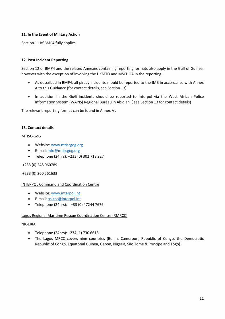
13. Contact details
MTISC-GoG
Website: www.mtiscgog.org
E-mail: [email protected]
Telephone (24hrs): +233 (0) 302 718 227
+233 (0) 248 060789
+233 (0) 260 561633
INTERPOL Command and Coordination Centre
Website: www.interpol.int
E-mail: [email protected]
Telephone (24hrs): +33 (0) 47244 7676
Lagos Regional Maritime Rescue Coordination Centre (RMRCC)
NIGERIA
Telephone (24hrs): +234 (1) 730 6618
The Lagos MRCC covers nine countries (Benin, Cameroon, Republic of Congo, the Democratic
Republic of Congo, Equatorial Guinea, Gabon, Nigeria, São Tomé & Príncipe and Togo).
12
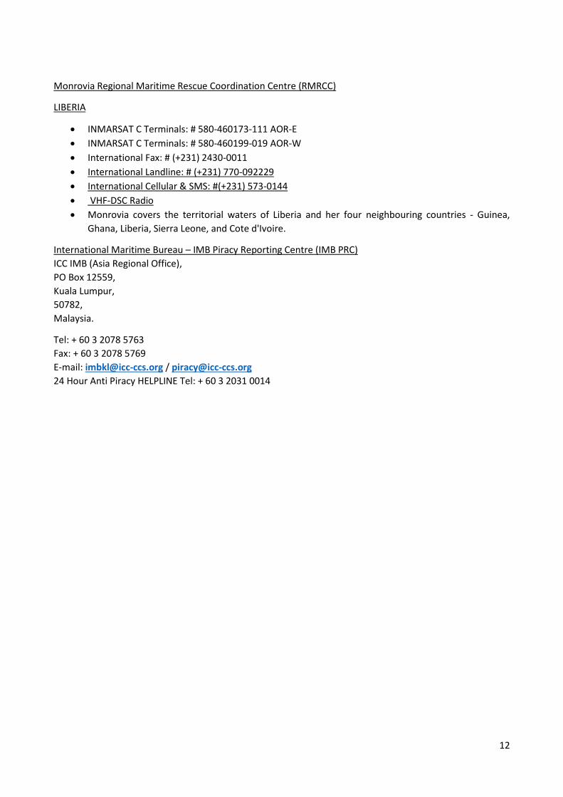
Monrovia Regional Maritime Rescue Coordination Centre (RMRCC)
LIBERIA
INMARSAT C Terminals: # 580-460173-111 AOR-E
INMARSAT C Terminals: # 580-460199-019 AOR-W
International Fax: # (+231) 2430-0011
International Landline: # (+231) 770-092229
International Cellular & SMS: #(+231) 573-0144
VHF-DSC Radio
Monrovia covers the territorial waters of Liberia and her four neighbouring countries - Guinea,
Ghana, Liberia, Sierra Leone, and Cote d'Ivoire.
International Maritime Bureau – IMB Piracy Reporting Centre (IMB PRC)
ICC IMB (Asia Regional Office),
PO Box 12559,
Kuala Lumpur,
50782,
Malaysia.
Tel: + 60 3 2078 5763
Fax: + 60 3 2078 5769
E-mail: [email protected] / [email protected]
24 Hour Anti Piracy HELPLINE Tel: + 60 3 2031 0014
13
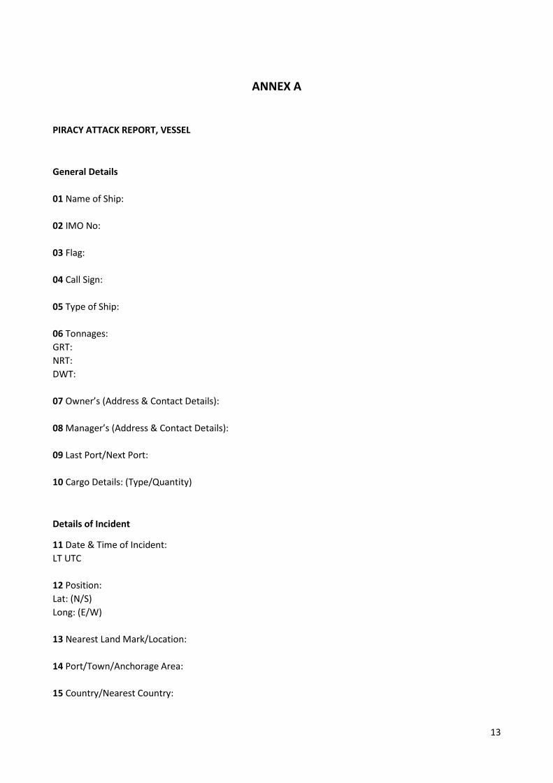
ANNEX A
PIRACY ATTACK REPORT, VESSEL
General Details
01 Name of Ship:
02 IMO No:
03 Flag:
04 Call Sign:
05 Type of Ship:
06 Tonnages:
GRT:
NRT:
DWT:
07 Owner’s (Address & Contact Details):
08 Manager’s (Address & Contact Details):
09 Last Port/Next Port:
10 Cargo Details: (Type/Quantity)
Details of Incident
11 Date & Time of Incident:
LT UTC
12 Position:
Lat: (N/S)
Long: (E/W)
13 Nearest Land Mark/Location:
14 Port/Town/Anchorage Area:
15 Country/Nearest Country:
14
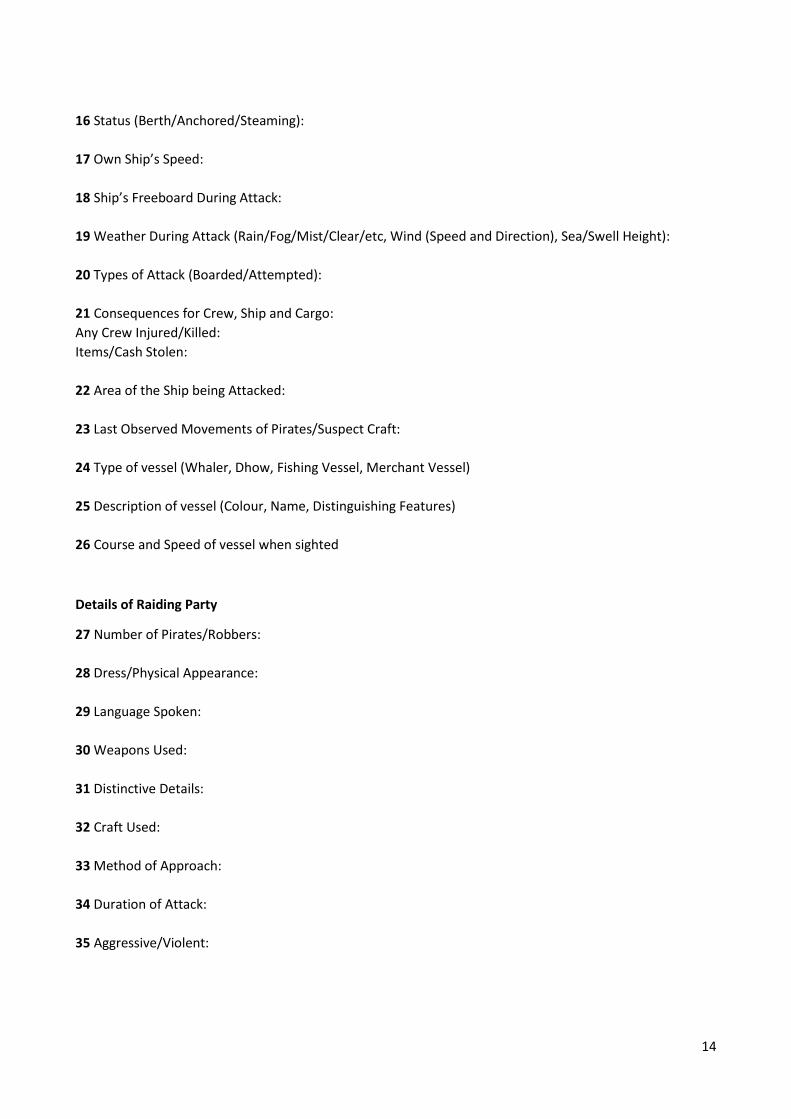
16 Status (Berth/Anchored/Steaming):
17 Own Ship’s Speed:
18 Ship’s Freeboard During Attack:
19 Weather During Attack (Rain/Fog/Mist/Clear/etc, Wind (Speed and Direction), Sea/Swell Height):
20 Types of Attack (Boarded/Attempted):
21 Consequences for Crew, Ship and Cargo:
Any Crew Injured/Killed:
Items/Cash Stolen:
22 Area of the Ship being Attacked:
23 Last Observed Movements of Pirates/Suspect Craft:
24 Type of vessel (Whaler, Dhow, Fishing Vessel, Merchant Vessel)
25 Description of vessel (Colour, Name, Distinguishing Features)
26 Course and Speed of vessel when sighted
Details of Raiding Party
27 Number of Pirates/Robbers:
28 Dress/Physical Appearance:
29 Language Spoken:
30 Weapons Used:
31 Distinctive Details:
32 Craft Used:
33 Method of Approach:
34 Duration of Attack:
35 Aggressive/Violent:

15
Further Details
36 Action Taken by Master and Crew and its effectiveness:
37 Was Incident Reported to the Coastal Authority? If so, to whom?
38 Preferred Communications with Reporting Ship:
Appropriate Coast Radio Station/HF/MF/VHF/INMARSAT
IDS (Plus Ocean Region Code)/MMSI
39 Action Taken by the Authorities:
40 Number of Crew/Nationality:
41 Please attach with this Report – A Brief Description/Full Report/Master – Crew Statement of the
Attack/Photographs taken if any.
42 Details of Self Protection Measures.
Related links
Best Management Practices for Protection against Somalia Based Pira...
Interim Guidelines for Owners, Operators and Masters for protection...20.12.12
16
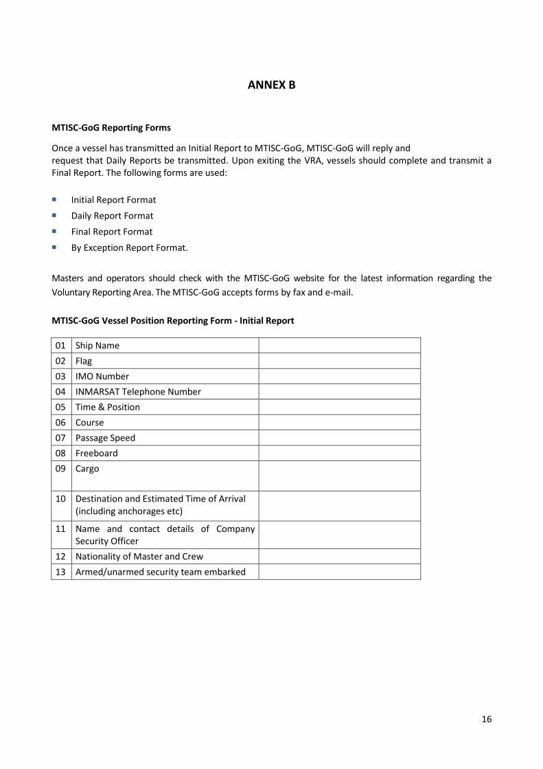
ANNEX B
MTISC-GoG Reporting Forms
Once a vessel has transmitted an Initial Report to MTISC-GoG, MTISC-GoG will reply and request that Daily Reports be transmitted. Upon exiting the VRA, vessels should complete and transmit a Final Report. The following forms are used:
Initial Report Format
Daily Report Format
Final Report Format
By Exception Report Format.
Masters and operators should check with the MTISC-GoG website for the latest information regarding the
Voluntary Reporting Area. The MTISC-GoG accepts forms by fax and e-mail.
MTISC-GoG Vessel Position Reporting Form - Initial Report
01 Ship Name
02 Flag
03 IMO Number
04 INMARSAT Telephone Number
05 Time & Position
06 Course
07 Passage Speed
08 Freeboard
09 Cargo
10 Destination and Estimated Time of Arrival (including anchorages etc)
11 Name and contact details of Company Security Officer
12 Nationality of Master and Crew
13 Armed/unarmed security team embarked

17
MTISC-GoG Vessel Position Reporting Form - Daily Position Report
01 Ship’s name
02 Ship’s Call Sign and IMO Number
03 Time of Report in UTC
04 Ship’s Position
05 Ship’s Course and Speed
06 Any Other Important Information
MTISC-GoG Vessel Position Reporting Form - Final Report
01 Ship’s name
02 Ship’s Call Sign and IMO Number
03 Time of Report in UTC
04 Port or position when leaving the VRA
MTISC-GoG By Exception Report (Suspicious Activity)
01 Own Ship name
02 Ship’s Call Sign and IMO Number
03 Time of Report in UTC
04 Own Ship Position
05 Own Ship Course and Speed
06 Sightings of Illegal Unlawful Unregulated (IUU) fishing or other assessed illegal activity. Time, Position, brief description of craft and
activity witnessed