Embed Size (px)
Citation preview
GUIDELINES FORMINERAL EXPLORATION
DECEMBER 1982
TABLE OF CONTENTS
Page
CHAPTER I-INTRODUCTION ...
CHAPTER II-LEGISLATION AND APPROVALS....................... 3Ministry of Energy, Mines and Petroleum Resources Approvals 3
Requirement to give notice-section 6 (1), Mines Act 3Approval of underground work-section 6 (2), Mines Act 3Approval of Reclamation Program-section 7-11, Mines Act 4
Procedure for obtaining a reclamation permit....... 4Procedure for maintaining a reclamation permit..................... 5General Reclamation permits.... . 5
Summary of other legislative requirements ... 6
7777788888
. 9101010111111141415151518181818191919
Drilling ....Trenching .
Hand Trenching ...Backhoe Trenching .Bulldozer Trenching .
Underground Development .
CHAPTER III-WORK GUiDELINES ....Clearing and slash abatement...
Clearing ...Abatement ...
Burning .Burying .Lopping and Scattering ..Chipping .
Road Construction .DesignConstruction ...Winter construction ...Drainage ...
DesignPlanning .Permanent Roads .Temporary Roads .
Stream crossings ..General .Bridges .Culverts ..Fords ...Debris Bridges ...
CHAPTER IV-RECLAMATION GUIDELINES... . 21Campsites... . 21Trenches, Drillsites and Major Excavations 21Roads... . 21
Permanent Roads.. . 21Abandoned Roads ... . 21
Revegetation Methods.... .. 22Methods of seed and fertilizer application 22Recommended seed mixtures... . 22Recommended fertilizer applications .. .. 23
TABLE OF CONTENTS-Continued
APPENDICES Page
A Uranium Moratorium Regulation ... . 27
B Addresses of regulatory agencies... . . .....u. 29
C Mines Act, Sections6-11..u..u ....u... 31
D Notice of Work and Reclamation Program on a Mineral Property ··.U.. U... u 35
E Design for a simple pipe-stem harrow uu .uu.u .. uu...uu.u.............. 39
F Recommended Reclamation treatments . u... uu.u.u u... . u. 41
G Suggested seed mixtures for use on areas disturbed by exploration activities in BritishColumbia... . u.u uu u u 45
I.INTRODUCTION
These guidelines are written to inform individuals and companies on the requirements for conductingmineral exploration in British Columbia in compliance with the Mines Actand in harmony and with dueregard for the Province's other resources.
Exploration for uranium is not permitted in British Columbia at the time of writing of these Guidelines(Appendix A, Uranium Moratorium).
These guidelines do not outline the procedures under the Mineral Act. For questions concerning theMineral Act contact one of the offices of the Gold Commissioner (Appendix B).

II.LEGISLATION AND APPROVALS
There are several acts and statutes which may govern mineral exploration. The first section of thischapter outlines the approvals required by the Ministry of Energy, Mines and Petroleum Resources(MEMPR) under the Mines Act (Appendix C) and the referral system which is used. Approvals fromother agencies may be required depending upon the location, land tenure, and nature of theexploration program; and are outlined in the second section of this chapter. Although many of theseapprovals will be initiated by contact with the Inspector of Mines and Resident Engineer, theresponsibility for obtaining these approvals rests with the proponent.
2.1 MINISTRY OF ENERGY, MINES AND PETROLEUM RESOURCES APPROVALS
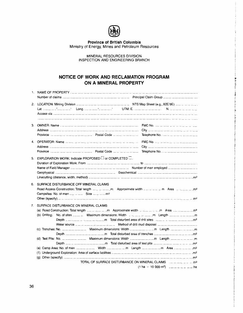
To initiate all approvals and requirements of the Ministry of Energy, Mines and PetroleumResources an operator must complete a Notice of Work and Reclamation Program on a MineralProperty and submit it to the Inspector of Mines and Resident Engineer. Depending upon thenature of the exploration program, up to two months may be required before all permits andapprovals will be issued, therefore, applications should be initiated well before work is planned.
REQUIREMENT TO GIVE NOTICE (Section 6 (1), Mines Act)
The Notice of Work and Reclamation Program on a Mineral Property (Appendix D) must bereceived by the Inspector of Mines and Resident Engineer at least 7 days before commencingexploratory work. Providing this notice does not imply that the applicant can start work after 7days. The applicant may only commence work when all additional approvals are received.
At least 7 days before ceasing work an operator must also give notice to the Inspector of Minesand Resident Engineer by completing and submitting a Notice of Work and ReclamationProgram on a Mineral Property
APPROVAL OF UNDERGROUND WORK (Section 6, Mines Act)
These procedures apply to underground exploration including the rehabilitation of workings forthe purpose of surveying, mapping, sampling, and drilling and also apply to undergrounddevelopment work including drifting, crosscutting, raising, and drilling. These procedures do notapply to mines wishing to go into production. Requirements for mines wishing to go intoproduction are outlined in the Procedures for Obtaining Approval of Metal Mine Development.
Under section 6 (2) of the Mines Act, the owner, agent, or Manager of the mine must have thewritten approval of the Chief Inspector of Mines before working underground. To obtain thisapproval the following information must be submitted to the Inspector of Mines and ResidentEngineer for transmittal to the Chief Inspector of Mines.
• Proposed work outlined on a Notice of Work and Reclamation Program on a MineralProperty
• A detailed map of present and proposed underground workings.
3
4
• A detailed plan of surface installations in relation to mine openings.
• A detailed plan of the system or method of carrying out the proposed work.
All work in and about the mine must be carried out in accordance with the Mines Act including thefollowing:
• A manager must be appointed under section 25, Mines Act. This person may also act as ashiftboss if he has the necessary certification.
• All work must be under the supervision of a certified shiftboss (section 24). The shiftbossmust ensure that all work done in and about the mine is in compliance with the Mines Act.
• All miners must have medicals and Certificates of Fitness which must be filed in the mineoffice.
• The ventilation system must meet the requirements of the Mines Act and be maintainedby the manager to the satisfaction of the Inspector of Mines and Resident Engineer.
• A permit must be obtained from the Chief Inspector of Mines for each diesel engine used.Forced ventilation equipment and requirements to be detailed by description and onplans. Gas testing equipment and record book to be kept up to date by the shiftboss.Obtain Application for a Permit to Operate a Diesel Engine Underground, and send to theInspector of Mines and Resident Engineer.
• To store and use explosives at a mine, written permission is required from the Inspector ofMines and Resident Engineer. Such permission is granted if the mine can and will complywith explosives and blasting regulations of the Mines Act and Federal ExplosiveRegulations.
• All machines must be muffled to the approval of the Environmental Control Inspector andoperators must have personal hearing protection (muffs).
• All buildings must meet the requirements of the Building Code and Electrical Code V
• First aid must be maintained in compliance with First Aid Regulations issued under theMines Act.
APPROVAL OF RECLAMATION PROGRAM (Sections 7-11, Mines Act)
A reclamation permit must be obtained before commencing an exploration program involvingsurface disturbance. The procedure for obtaining this permit is outlined below and involves anapplication, a review by other resource agencies, establishment of special terms and conditionson the permit and placing of a performance bond. Four factors enter into consideration indetermining the value of the reclamation bond: the amount of land disturbed; ease of reclamation; environmental sensitivity; and the companies' past performance. The advantages to acompany maintaining a progressive reclamation program are obvious. The maximum bond is$2 500.00 per hectare of disturbance.
PROCEDURE FOR OBTAINING A RECLAMATION PERMIT
APPLICANT: Sixty days before commencing work on a mineral property, the applicant contactsthe Ministry of Forests and completes and submits a Notice of Work and Reclamation Program on a Mineral Property to the Inspector of Mines and ResidentEngineer.
MEMPR: Inspector of Mines and Resident Engineer circulates Reclamation Program toother resource agencies.
At the end of 30 days, comments are received, bonding and conditions are set,and recommendations are forwarded to the Senior Reclamation Inspector inVictoria. If any resource agencies have statutory responsibilities, and the applicant has not taken steps to fulfill these then the applicant will be notified at this

time. Chief Inspector of Mines approves program (within 60 days of the time thatthe application is first received).
Senior Reclamation Inspector notifies applicant of the amount of bonding.
APPLICANT: Arranges for bonding at bank and sends Receipt and Agreement form to SeniorReclamation Inspector.
MEMPR: Once the completed Receipt and Agreement form has been received, the Reclamation Permit is issued to the operator.
OPERATOR: Upon completion of Reclamation Program, the operator can either request returnof bonding or maintain the permit in good standing.
MEMPR: If the operator requests a return of bonding then the Reclamation InspectorTechnician inspects the property and, if all terms and conditions of the permithave been met, bonding is returned.
PROCEDURE FOR MAINTAINING A RECLAMATION PERMIT
Existing permits can be amended by annually submitting a Notice of Work and ReclamationProgram on a Mineral Property at least 60 days prior to commencement of work. The existingpermit will be either amended to approve this work without an increase in security or thepermittee will be asked to post an additional security. Upon receipt of this security the permit willbe amended approving the proposed reclamation program.
GENERAL RECLAMATION PERMITS
General Reclamation Permits can be issued, upon application by letter to the Chief Inspector ofMines, to those companies which maintain a number of projects in the Province of BritishColumbia. This permit covers all the company's projects, thereby greatly simplifying the bondingprocedure. The company is still required to submit to the Inspector of. Mines and ResidentEngineer, for each property, a Notice of Work and Reclamation Program on a Mineral Propertyannually and these are circulated to other resource agencies.
To renew or obtain a general reclamation permit for mineral exploration:
APPLICANT: Sends a letter to Chief Inspector of Mines, requesting a general reclamationpermit (or renewal of an existing permit). This letter should include a summary ofeach property:
• Name of property.
• Location.
• Owner.
• Operator.
MEMPR: Reviews and sets bonding and sends applicant a copy of the proposed permitand Receipt and Agreement forms.
APPLICANT: Takes Receipt and Agreement forms to bank, deposits secunty, and forwardscompleted Receipt and Agreement form to Senior Reclamation Inspector.
MEMPR: Permit is then issued by Chief Inspector of Mines.
To maintain a general mineral exploration permit:
Operator, 30 days before working on a property, must annually submit Notice of Work andReclamation Program on a Mineral Property to the Inspector of Mines and Resident Engineer.Properties not already included in the general reclamation permit for mineral exploration will beautomatically added upon receipt of the Notice of Work. The Notice and Program will becirculated to other resource agencies.
5
Bonding and terms and conditions of the permit may be revised at any time depending upon theextent of exploration activity, comments from review agencies, and on the operator's performance record.
To terminate the permit, the operator must apply to the Senior Reclamation Inspector for releaseof the bond. The Senior Reclamation Inspector, upon a satisfactory inspection of all properties,will arrange for release of bond.
2.2 SUMMARY OF OTHER LEGISLATIVE REQUIREMENTS
FOREST ACT
On Crown land administered by the Ministry of Forests a free miner is required to obtain thefollowing when necessary.
Free Use Permit-to cut and use timber for mining purposes on mineral claimsLicence to Cut -to cut timber for camp sites, roads, drill sites, portal sitesRight of Way -for roads through forest reserve land, but does not include work on mineral
claimsContact -any Forestry office or Regional Manager (Appendix B)
LAND ACT
Ministry of Lands, Parks and Housing has jurisdiction over Crown land other than that landadministered by the Ministry of Forests.
Right of Way -for access roads to a mineral property but does not include roads on amineral property
Contact -either Regional Director or District Manager (Appendix B)
WATER ACT
The Ministry of Environment, Water Management Branch issues water licences for water usefrom creeks, rivers, or lakes.
Contact -Regional Manager (Appendix B)
FISH AND WILDLIFE, MINISTRY OF ENVIRONMENT
There is no act governing the protection of wildlife habitats other than the Federal Fisheries Act.The Regional Fish and Wildlife Branch receives copies of Notice of Work and ReclamationProgram on a Mineral Property from the Inspector of Mines and Resident Engineer. Anyconcerns are taken into consideration and any conflicts are usually resolved at the regional level.The company doing the exploration work may be instructed to avoid or minimize impacts onhabitats or fisheries.
POLLUTION CONTROL ACT
Depending on the size of the exploration camp, sewage and garbage disposal are covered underthe Public Health Act or Pollution Control Act.
6
Contact -Regional Manager (Appendix B)
III.WORK GUIDELINES
All mineral exploration permits will be issued subject to these Guidelines for Mineral Exploration.
Based upon recommendations from other agencies, the Chief Inspector of Mines may issue a permitwith special conditions and place added restrictions upon proposed activities. These may be eithertime restrictions to avoid conflicts with other resource users or equipment restrictions to minimizedisturbance in environmentally sensitive areas.
3.1 CLEARING AND SLASH ABATEMENT
Clearing of forests and slash disposal are controlled under the jurisdiction of the Ministry ofForests. Where timber is to be cut or destroyed in exploration operations, a Licence to Cut Timbermust be obtained from the local Ministry of Forests office. Similarly, for timber to be used in minedevelopment, a Free Use Permit must be obtained. Pursuant to section 117 of the Forest Act, anorder to abate slash hazard will be issued when required, and will generally call for slashtreatments similar to the following:
CLEARING
Pre-logging of road rights-of-way is encouraged and, in some areas, may be required. In thisprocedure, merchantable timber, usually in lengths greater than 2.5 metres long with a topdiameter over 15 centimetres is decked and later sold by the Ministry of Forests. Prelogging hasbeen found to yield a more stable road bed and, in many cases, has substantially offset slashabatement costs.
On main roads, all trees must be felled onto the right-of-way, and those trees not utilized must betotally disposed of by burning or burying.
On temporary roads and on drilling, trenching, portals or similar sites, all trees pushed over maybe disposed of by lopping and scattering. In no case shall trees be left leaning. Total disposal isrequired within 400 metres of where any temporary road crosses a river or permanent main road.
ABATEMENT
Burning
All burning requires a permit issued by the local Ministry of Forests office. Within the PrinceGeorge and Prince Rupert Forest Regions a permit is only required between April 15 andOctober 15. Periods of high fire hazard may result in the cancellation of burning permits until morefavourable conditions prevail.
Material under 20 centimetres in diameter should be piled not less than 5 metres away from theforest margin and burned when weather conditions permit. Larger material may be burned in a
7
similar manner or, if this is not possible, bucked so that it is in close contact with the ground andwindrowed at least 5 metres from the forest margin. Unburned stumps may be scattered singlyalong the right-of-way along with any charred material remaining after burning. In no case maydebris be left bunched or in piles.
Burying
Burying is an acceptable method of slash disposal in most situations but requires a high level ofsupervision to ensure a satisfactory job.
Disposal areas must be cleared and a pit constructed to receive slash. Material to be buried mustbe cut into lengths less than 4 metres long and compacted within the pit so that nothing protrudesabove ground level. Compacted piles should then be covered with at least 1 metre of mineral soilthen seeded and fertilized.
Lopping and Scattering
On winter or temporary access roads, provided their width is less than 10 metres, slash may bedisposed of by lopping and scattering. When this method is used, all trees felled must be limbedand the branches scattered. Boles of trees must be cut from the stump at the root crown andbucked so that they lie in close contact with the ground.
Total disposal is required within 400 metres of where winter or temporary roads cross any river orpermanent road on which total disposal is required. Total disposal may be required at thediscretion of the Ministry of Forests.
Chipping
Chippers have been used successfully for the disposal of slash less than 25 centimetres indiameter. When used in conjunction with prelogging the requirement for burning or burying isgreatly reduced.
3.2 ROAD CONSTRUCTION
Poor road design and construction can account for a large proportion of disturbance in anexploration program. The following sections outline a number of guidelines for correct roaddesign and construction.
DESIGN
Use existing roads whenever possible. Build the narrowest road possible consistent with safetyand traffic needs. Plan for minimum permanent road length through use of main access roadsand secondary tote roads.
Avoid sensitive areas. Areas may be sensitive because of conflicts with other resources orbecause of problems in construction or reclamation. Some examples of sensitive areas are:
• Wildlife winter ranges (southwest-facing grassy or shrubby slopes), saltlicks.
• Highly erodible areas, that is, fine-textured soils, steep slopes (Table 1).
• Areas directly visible from recreational areas.
• Streams, lakes, marshes, bogs.
• Alpine areas.
Locate roads to fit the topography, making use of natural benches, ridgetops, and flatter slopes toavoid extensive cuts and fills. This will not only reduce construction costs but will avoid thepossibility of unstable cut or fill slopes.
8
TABLE 1. GUIDE FOR ASSESSING SOIL EROSION HAZARD
SLOPE
0-3° 3-5° 5-17° 17-31° 31°TEXTURE 0-5% 5-9% 9-30% 30-60% 60%
Fine. Moderate High High High HighFine to medium ... Moderate Moderate High High HighMedium ...... Low Low Moderate High HighMedium to coarse ... Low Low Moderate Moderate HighCoarse .... Low Low Low Moderate High
Locate roads so that no portion of the road, including fill material lies within 50 metres of a creekor lake, except at stream crossings. The permission of an Inspector must be obtained beforeroads can be located within this limit.
Roads should be designed to keep grades as low as possible (Table 2).
TABLE 2. SOME APPROXIMATIONS REGARDING SLOPES
GRADIENT
REMARKS
Maximum for main haulage ...Short pitches ...Approximate two-wheel drive maximum ...Maximum soil slope for vegetation ..Angle of repose earth fill.. ..Angle of repose loose angular rock ...
CONSTRUCTION
per cent
81015506780
degrees horizonta/:vertica/
5 11 :16 10:19 6:1
26 2:134 1.5:139 1.25:1
Proposed access routes must be inspected on foot and flagged at least 2 kilometres in advanceof any construction equipment. Site specific relocations may then be made to avoid problemareas.
Clear only the minimum area, having due regard for ditching and slash disposal. Before clearingborrow pits, test the area to ensure that adequate quantities exist.
Obtain road gravel from approved locations.
Where construction must take place in unstable soils or adjacent to major steams, try to takeadvantage of dry weather.
In level terrain such as alpine tundra, where cuts and fills are not required, tracked vehiclesshould be used for access without actual road construction. Road alignments must be clearlyflagged to ensure that travel is confined to selected routes. This is especially important duringwinter white-outs.
Stabilize fill material by:
• Removing roots, vegetation, and large rocks.
• PUlverizing large lumps of soil before compaction.
• Controlling groundwater so that the base of filled sections does not become saturated. Inareas of extreme groundwater, perforated pipe encased in a crushed rock filter or an entireblanket of crushed rock should be placed under the fill.
• Depositing fill away from the high-water zones of streams. If this is not possible, rip-rapshould be used to stabilize the toe of the slopes against erosion during high water.
• Constructing fill in lifts to achieve maximum compaction.
9
10
Avoid roadside slumping by:
• Reducing the slope angle of cut banks, rounding the tops of cut slopes, and falling anytrees that may be undercut by erosion.
• Not disturbing the· toes of cut slopes when maintaining roads.
• Stabilizing potentially unstable slopes by leaving a top dressing of light slash or byimmediate seeding and/or mulching to establish vegetation cover; in difficult situations,rip-rap, terrace, or crib slopes.
Berms are to be left on roads traversing steep slopes; however, they must be breached atappropriate intervals and removed where not required so that runoff is not concentrated on theroad surface.
Reduce the road width or endhaul material on steep slopes. Special equipment such as small'cats' with U-blades may be required to reduce road width. Endhauling will require a backhoe anddump truck as well as a suitable site for waste disposal. Full bench construction is preferable onsteep slopes and mandatory on slopes exceeding the angle of repose (Table 2).
WINTER CONSTRUCTION
Road construction may be permitted during winter months under certain conditions. The maindeterrents to winter construction are excessive snow depths, extreme groundfrost conditions,and steep topography. Given favourable conditions, construction projects undertaken duringwinter may prove less damaging than construction during the summer particularly in areas wherehigh groundwater levels can result in serious erosion and stability problems during summermonths. Properly constructed ditches and culvert crossings will control groundwater and surfacerunoff during spring breakup, resulting in a more stable roadbed.
In forested areas, sufficient right-of-way must be cleared to facilitate removal of snow from theproposed road grade. Since this will require more clearing than normally recommended fortemporary roads, winter construction should only be considered for permanent main roads.
Regulations for construction of winter roads:
• Avoid steep grades and side-slopes.
• Do not incorporate snow or ice into fill.
• Construct road with a high grade in wet areas.
• Cover road surface with rock or shale in areas of fine-textured soil.
• Install culverts and ditches as construction progresses.
DRAINAGE
Drainage design is the single most important element of road layout. Time spent, beforeconstruction, in identifying the drainage requirement of each section of road and ensuring thatthe appropriate machinery and materials are available will be compensated fully by savings inconstruction and maintenance costs.
Design
Drainage systems should be designed on a site specific basis and must be designed to handlethe maximum expected runoff.
Drainage systems should be upgraded on areas of rapid runoff. High runoff will occur on:
• Areas of steep slopes.
• Areas of shallow soils.
• Areas of impeNious fine-textured soils.
• Non-forested areas.
• South and west-facing slopes where snow melt is rapid.
PlanningSupply a sufficient number of culverts large enough to accommodate anticipated high waterflows and sediment loads.
Mark the location, size, and type of culvert on a layout plan and give to operators.
Permanent Roads
On frequently used or permanent roads, or in highly erodible soils, a system of ditches andculverts must be installed keeping in mind the following criteria:
• Ditches and culverts must be large enough to accommodate the maximum anticipatedflow. A drainage system that cannot carry the maximum runoff is worse than no system atall because the water is concentrated in one channel and can cause serious erosion.Culverts should be installed at frequent inteNals to prevent a large quantity of water beingdischarged onto the lower slope at one time. Where necessary, spacing should be alteredto avoid spilling onto unstable slopes.
Catch basins should be constructed above culvert inlets with ditch blocks placed belowthe basins to direct water through the culvert (Figure 1). Be sure to clear drainage ways ofall construction debris and do not allow fill material to block inlets. Rip-rap placed on theditch block will prevent erosion or washout. Culverts should be marked with large flaggedstakes so that they can be checked regularly and will not be buried by maintenanceequipment.
• Keep roads crowned so that water flows into the ditches rather than collecting on the roadand roll road grades to avoid long, steep hills where water will flow along the surfacebefore entering ditches.
• Culverts should be skewed to the same degree as water bars and should have a minimum1 per cent slope. Under conditions of high debris load or unstable deep fills, considerinstalling culverts along the natural slope (Figure 1). This procedure requires a longculvert which must be installed before any fill is laid but improves the self-cleaningcapability of the culvert and avoids discharge onto the fill slope.
• Discharge should be directed onto stable slopes. Place rocks or other obstacles below theoutlet to prevent erosion (Figure 1). Whenever possible, take advantage of low fills torelease water. If, however, drainage must be discharged over a deep fill, down-spouts,usually half-culverts, should be used (Figure 1). Route all drainage onto the forest floor sothat sediment can settle out before the water reaches a stream. Unmerchantable timberand slash from the road right-of-way may be windrowed along the toe of the fill slope toassist in the filtering process.
• Special care should be taken to divert drainage so that it does not collect in borrow pits orwaste dumps.
Temporary RoadsOn seldom used temporary roads, dips or water bars may be used for drainage and erosioncontrol (Figure 2). These must be close enough together so that the amount of water collectedcan be easily diverted. Appropriate spa.cing of water bars on various slopes in different soils isgiven in Figure 2. These inteNals are approximate and should be modified to avoid divertingwater onto deep fills or unstable natural slopes. Water bars should be skewed to allow water todrain downhill across the road. As an extra protective measure water bars must be installed at theend of each field season along the entire road network.
11
X-SECTION THROUGH CULVERT
12
CATCH BAS I N ----~.,..--~~--=::.".......;;==:::kCULVERT~ ...............
X-SECTION THROUGH CULVERT INSTALLED
ALONG THE NATURAL SLOPE
FIGURE 1
CULVERT INSTALLATION ON PERMANENT ROADS
1/2 CULVERT DOWNSPOUT
I
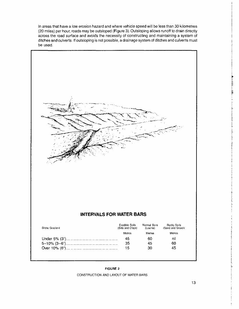
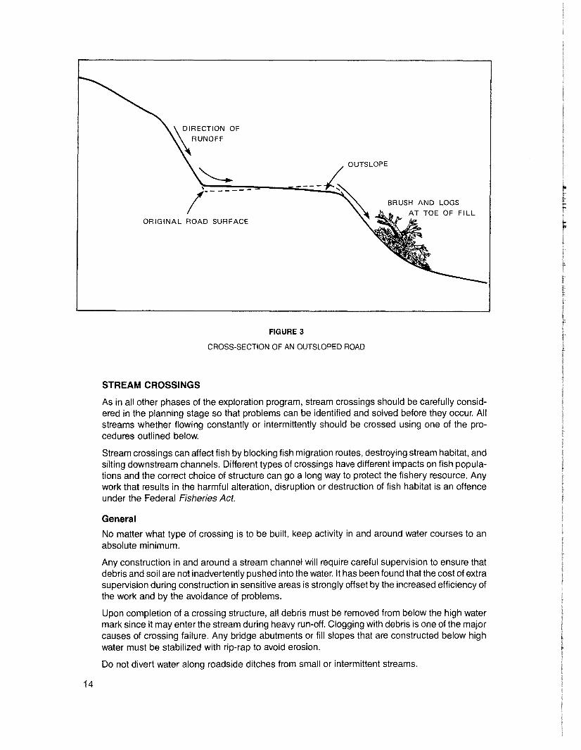
In areas that have a low erosion hazard and where vehicle speed will be less than 30 kilometres(20 miles) per hour, roads may be outsloped (Figure 3). Outsloping allows runoff to drain directlyacross the road surface and avoids the necessity of constructing and maintaining a system ofditches and culverts. If outsloping is not possible, a drainage system of ditches and culverts mustbe used.
INTERVALS FOR WATER BARS
Slope Gradient
Under 5% (3°) ..5-10% (3-6°) .Over 10% (6°) ..
Erodible Soils Normal Soils Rocky Soils(Silts and Clays) (Loams) (Sand and Gravel)
Metres Metres Metres
45 60 nil35 45 6015 30 45
FIGURE 2
CONSTRUCTION AND LAYOUT OF WATER BARS
13
~DIRECTION OF
\\RUNOFF
BRUSH AND LOGS
AT TOE OF FILLORIGINAL ROAD SURFACE
FIGURE 3
CROSS-SECTION OF AN OUTSLOPED ROAD
STREAM CROSSINGS
As in all other phases of the exploration program, stream crossings should be carefully considered in the planning stage so that problems can be identified and solved before they occur. Allstreams whether flowing constantly or intermittently should be crossed using one of the procedures outlined below.
Stream crossings can affect fish by blocking fish migration routes, destroying stream habitat, andsilting downstream channels. Different types of crossings have different impacts on fish populations and the correct choice of structure can go a long way to protect the fishery resource. Anywork that results in the harmful alteration, disruption or destruction of fish habitat is an offenceunder the Federal Fisheries Act.
General
No matter what type of crossing is to be built, keep activity in and around water courses to anabsolute minimum.
Any construction in and around a stream channel will require careful supervision to ensure thatdebris and soil are not inadvertently pushed into the water. It has been found that the cost of extrasupervision during construction in sensitive areas is strongly offset by the increased efficiency ofthe work and by the avoidance of problems.
Upon completion of a crossing structure, all debris must be removed from below the high watermark since it may enter the stream during heavy run-off. Clogging with debris is one of the majorcauses of crossing failure. Any bridge abutments or fill slopes that are constructed below highwater must be stabilized with rip-rap to avoid erosion.
Do not divert water along roadside ditches from small or intermittent streams.
14
Bridges
Bridge crossings must be used on any streams supporting fish populations or on any stream witha channel width greater than 3 metres. Properly constructed bridges do not alter stream flowcharacteristics or stream habitat.
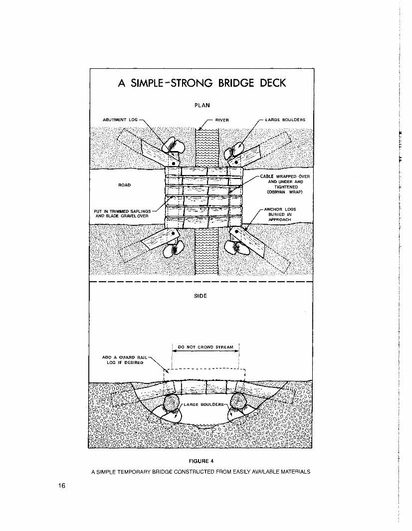
A plan for a simple log bridge suitable for crossing a small stream is given in Figure 4. This bridgecan be built of local materials, perhaps utilizing trees felled during road clearing.
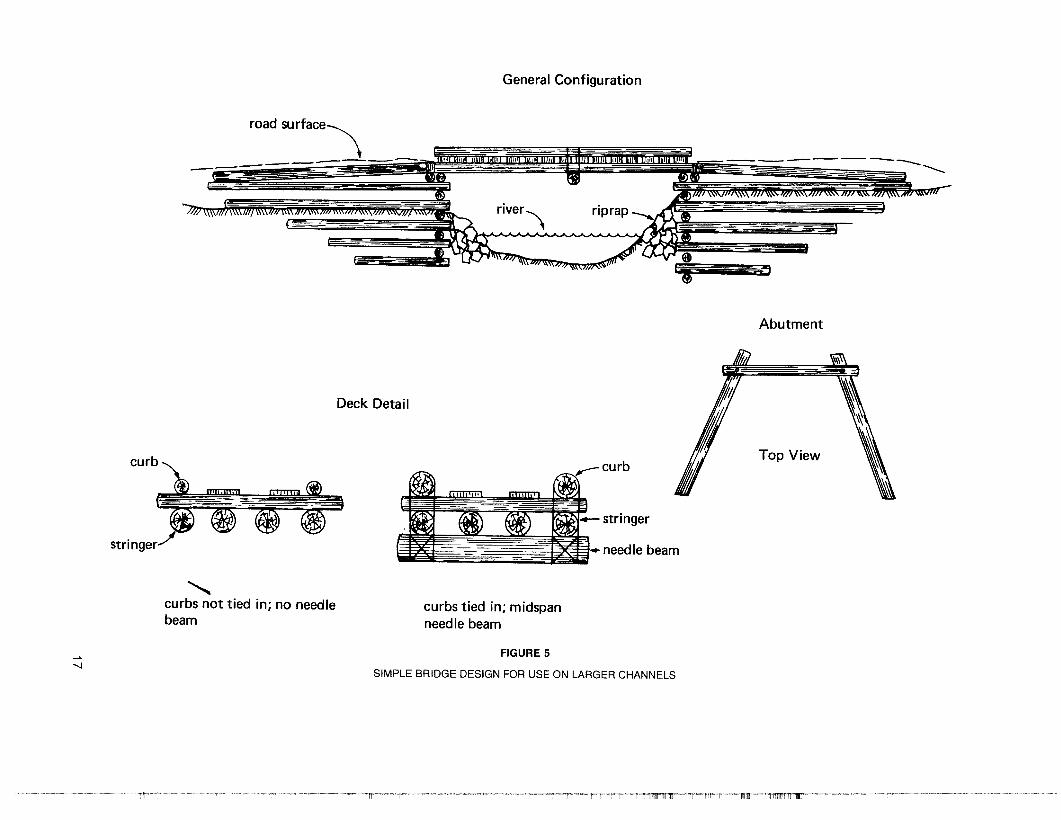
Figure 5 gives a bridge plan based on Ministry of Forests standards for use on larger channels.Large bridges should be engineered and built by personnel familiar with bridge construction.
Bridge construction guidelines:
• Rough-notch all crib joints to improve seating and reduce the spacing between logs.Some blocking may be necessary to prevent backfill from spilling out during floods, asloss of crib filling will lead to bridge failure. Use coarse gravel or cobbles to fill cribs as thismaterial is less likely to erode between the logs.
• Construct bridge spans that are long enough. Many failures have occurred because oferosion caused by abutments that were extended too far into the stream channel.
• Construct the bridge so that water will be able to flow around the structure via the oldbackwater channels in case of a large flood. Do not build up the road in these areas.
Culverts
Even when installed in the best possible manner, culverts disrupt stream habitat and increasewater velocity causing blockage to fish passage. Culvert crossings, therefore, are only recommended for small streams which do not support fish populations.
On streams not specifically designated as fish habitat, but where there is a possibility that fishexist, culverts may be used, provided that installation causes a minimum restriction to fishmigration and survival. A properly installed culvert will minimize the water velocity while maintaining as many natural stream characteristics as possible.
Hanging outfalls are to be avoided. These may be caused by improper installation or by erosion atthe outlet. The latter cause may be eliminated by covering the channel below the culvert with riprap.
Water velocity may be reduced by installing the culvert as level as possible while maintaining anacceptable flow. Installations should be deep enough in the existing bed to allow a sufficientdepth of water in the culvert to permit fish passage.
Under cold conditions, culverts may become filled with ice. Usually iced up culverts thaw muchmore slowly than the adjacent stream and may cause blockage to water. This can lead to roadflooding, washouts and disruption of fish passage. Larger culverts and a maintenance system forice removal may be required in cold conditions.
Fords
The use of fords as stream crossings requires the permission of the Ministry of Environment, Fishand Wildlife Branch.
Fords may be used only on channels with coarse, cobbly beds and must be constructed tominimize sediment release when entering and leaving the ford. Ford preparations may includeremoving large boulders and debris from the channel but the stream bed must not be bladed ormodified in any way. If a ford requires constant maintenance to remain passable, an alternatetype of crossing must be used.
Fords with a constructed concrete bed have been used on small creeks with high debris loadsand intermittent high discharge.
15
A SIMPLE-STRONG BRIDGE DECK
PLAN
ROAD
PUT IN TRIMMED SAPLINGSAND BLADE GRAVEL OVER
RIVER
CABLE WRAPPED OVERAND UNDER AND
TIGHTENED(OBRYAN WRAP)
16
SIDE
DO NOT CROWD STREAM
ADD A GUARD RAIL~
LOG IF DESIRED ~--------------------"'lI I
FIGURE 4
A SIMPLE TEMPORARY BRIDGE CONSTRUCTED FROM EASILY AVAILABLE MATERIALS
General Configuration
road SUrface~ _
--\_-- D'I---m__ .......::,-- ~
- --' -----=----- =
river,
--------~
~>W.-- - need Ie beam
Abutment
"K\\'-!!!It. ::::
Deck Detail /1;/ ,Top View
stringer
..........curbs not tied in; no needlebeam
curbs tied in; midspanneedle beam
-....J
FIGURE 5
SIMPLE BRIDGE DESIGN FOR USE ON LARGER CHANNELS
Debris Bridges
Debris bridges, consisting of fill and slash pushed into a stream channel for temporary orpermanent access, are not permitted.
3.3 DRILLING
The impact of drilling alone is quite small and can be minimized by proper planning and goodwork practices.
Although the location of drill holes is dictated by geological, geophysical, or geochemicalanomalies, slight relocations are often possible to avoid problem areas. Do not locate drill sites onunstable slopes, steep terrain, or wet areas as this will significantly increase construction andreclamation difficulties. Drill holes shall not be located within 50 metres of streams or lakesexcept with permission of an Inspector. Use the saf~st but smallest possible drill pad area. Treesshould be felled and bucked according to slashing guidelines.
If stripping or levelling of a drill site area is required for safe location of a drill pad, topsoil andoverburden must be removed and stockpiled for use in reclamation when the drill site isabandoned.
At the completion of drilling the site should be resloped and revegetated according to the sitepreparation and revegetation guidelines (Chapter IV-Reclamation GUidelines).
An adequate closed-circuit facility must be provided for drilling mud and flocculating agents. Drillsludge shall not be allowed to enter streams, lakes, or run uncontrolled. A small well-constructedsettling pond or sump a short distance down slope from the drill is usually adequate.
If, during drilling operations, any groundwater is released and flows to the surface, the drillholelocation must be immediately reported to an Inspector. If, in the opinion of the Inspector, theflowing hole is creating an environmental or health hazard the hole shall be cemented orotherwise plugged to prevent the flow of water.
Helicopter access drilling may be required in environmentally sensitive areas.
3.4 TRENCHING
Trenching has, in the past, caused severe disturbance in many areas.
For all trenching programs, preplanning is necessary to identify trench sites that will give thegreatest amount of information with the smallest amount of disturbance.
In all cases, trenches should be located at right angles to the strike on slopes less than 26degrees (2:1).
Overburden, to root depth, must be segregated for use in resloping. Under no circumstancesshould material be cast down hill. After geological work has been completed and before the endof the season, the trench must be reclaimed and revegetated according to the ReclamationGuidelines (Chapter IV).
Three methods of trenching are presently in use.
HAND TRENCHING
The major advantage of hand trenching is that road access to the trench site is not necessary.This greatly decreases the disturbed area and allows trenching on sites that are not otherwiseaccessible by machine. Because the trench itself is small and disturbance is limited, requirements for backfilling and reclamation are greatly reduced.
18
BACKHOE TRENCHING
The backhoe was designed as a trenching tool.
Backhoe trenches are usually quite narrow and thus cause little disturbance. Topsoil andoverburden are easily removed and stockpiled adjacent to the trench for use in resloping. Thehoe, a small 'eat', or a skidder may be used for backfilling and site preparation.
Backhoe trenches greater than 1.5 metres deep must have their walls sloped back or be providedwith adequate structural support to prevent collapse, if it is necessary for a person to enter forsampling or mapping.
BULLDOZER TRENCHING
Bulldozer trenching is not permitted except with permission of an Inspector.
3.5 UNDERGROUND DEVELOPMENT
Surface disturbances associated with underground development can present problems in erosion control, dump stability, and reclamation.
The following general guidelines shall be followed:
• Strip topsoil and overburden from the portal site, stockpile separately, and cover disturbances upon completion.
• Leave a minimum of 30 metres between any surface disturbance and a lake or stream.
• Provide for adequate drainage around the portal site and onto stable areas adjacent todisturbances.
• Ensure that waste rock is not placed in any watercourse.
• Portals must be closed upon completion of work or abandonment of the work site to thesatisfaction of the Inspector of Mines and Resident Engineer.
19

IV.RECLAMATION GUIDELINES
The following guidelines are minimum requirements and, depending upon the nature of the exploration activity and the environmental sensitivity of the area, increased standards may be required as acondition of the permit.
4.1 CAMP SITES
Camp sites which are to be abandoned shall be dismantled at the end of operations. All refuseshall be burned, buried, or removed. Pits shall be backfilled. The site shall be ripped, ifnecessary, to break surface compaction and revegetated.
Camp sites which are to be left for reuse shall be cleaned up. All refuse shall be burned, buried, orremoved. Pits shall be filled.
4.2 TRENCHES, DRILL SITES, AND MAJOR EXCAVATIONS
All trenches, drill sites, and major excavations shall be backfilled and recontoured as nearly aspossible to the previously existing slope. Stockpiled topsoil shall be spread over the site and theentire site shall be revegetated. Overland drainage shall be conducted around disturbances.Where this is not possible, erodible material must be protected by rip-rapping or other measures.
4.3 ROADS
It is important to identify those roads which can be abandoned and those roads which arenecessary for future exploration. Roads that will not be used the following field season should betreated as abandoned. Some portions of the road system may be required by the Ministry ofForests for permanent fire access. It is in the operator's interest to contact the Ministry of Forestsin this regard.
PERMANENT ROADS
Roads that are to be retained for permanent access shall be maintained annually.
Cut banks and fill slopes shall be revegetated.
ABANDONED ROADS
All abandoned roads should have a system of permanent erosion control. All culverts shall beremoved and suitable permanent drainage structures installed. Erosion bars shall be placed atfrequent intervals to ensure stability.
21
The requirement for recontouring roads will vary according to its location and the environmentalsensitivity.
• Roads on environmentally sensitive areas will require complete recontouring.
• Roads in alpine and high subalpine areas will require the pUlling back of topsoil material.
• Other roads will require ditching at their junction with permanent roads and ripping ofcompacted surfaces.
All abandoned roads shall be revegetated.
4.4 REVEGETATION METHODS
This section outlines revegetation treatments for the normal situation. Recommended seedmixtures are based upon the best available knowledge at this time. There is no guarantee thatthese treatments will be 100 per cent effective.
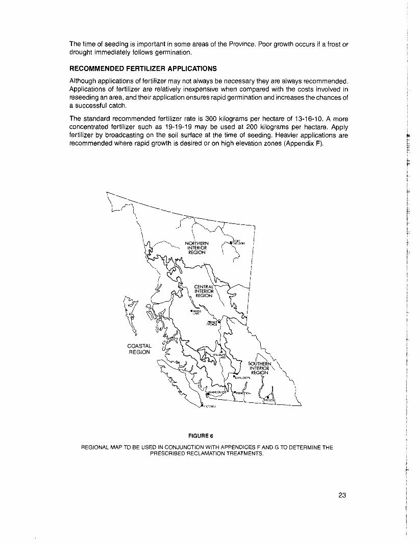
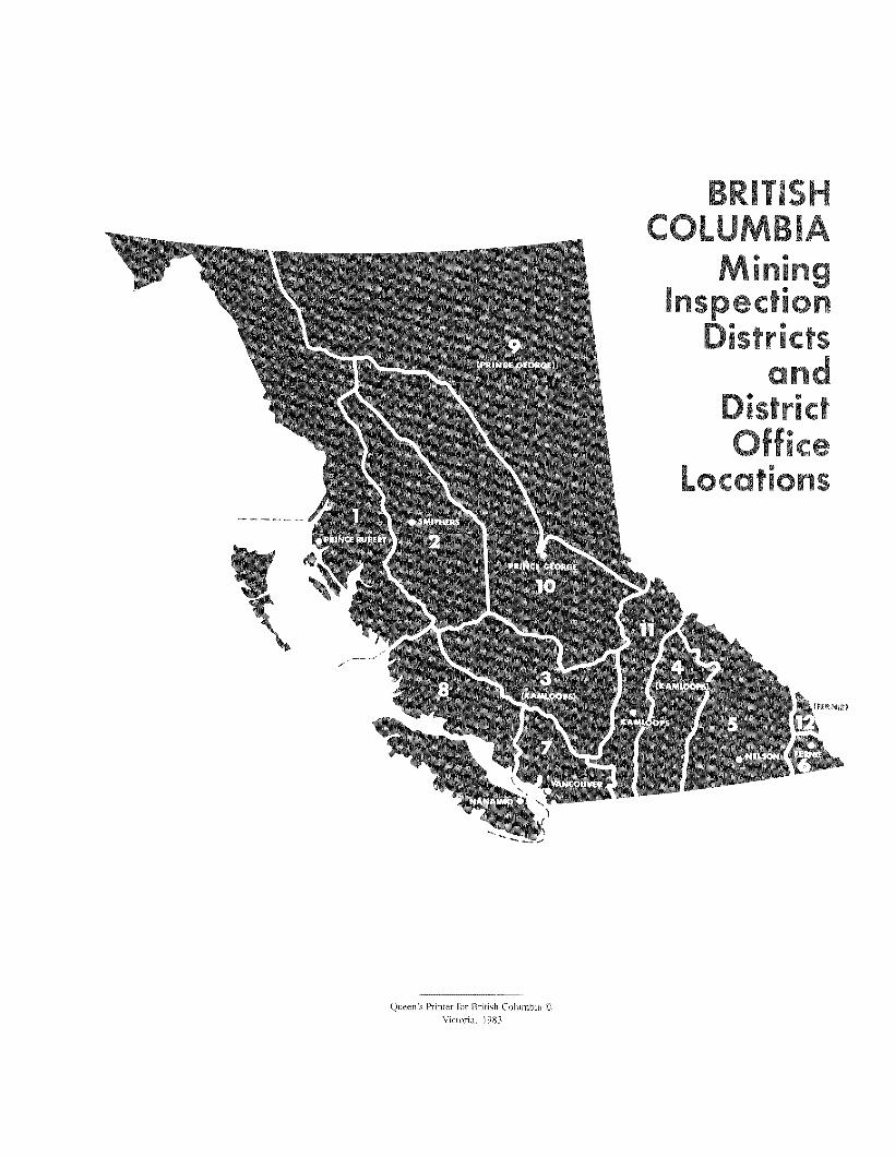
All areas must be stabilized and revegetated before return of the security bond and the operatormust be prepared to reseed unreclaimed areas. Revegetation prescriptions are given for all areasof British Columbia. To determine the prescription for your area, first find the region in which youare working on Figure 6 and then refer to Appendix F. In all instances, revegetation treatmentsrequire seed and fertilizer applications.
METHODS OF SEED AND FERTILIZER APPLICATION
Broadcasting is the usual method for applying seed and fertilizer. Seed may be broadcast byhand, hand-held cyclone seeders, spreaders mounted on all terrain vehicles, or spreadersmounted on helicopters or aircraft.
Success is increased, if following broadcasting, the seed is buried by a thin layer of soil. This maybe accomplished by running a tracked vehicle over the seed, or by harrowing the area. A designof a simple harrow is presented in Appendix E.
Hydroseeding is a technique whereby a slurry composed of seed, fertilizer, mulch (or soilstabilizer), and water is pumped through a nozzle and sprayed over the ground.
Agricultural seed drills can be used for seed and fertilizer applications. They are limited to wellprepared, level areas.
RECOMMENDED SEED MIXTURES
Recommended seed mixtures are presented in Appendices F and G. These mixtures oftencontain species that cannot be obtained locally and must be ordered from major seed suppliers inVancouver. Check availability of seed mixes locally before commencing surface work. Table 3gives some approXimations regarding seeding and fertilizing.
TABLE 3
SOME APPROXIMATIONS REGARDING SEEDING AND FERTILIZING
1 hectare is equal to-an area 100 m by 100 m-10,000 square metres-2.47 acres
1 hectare is approximately equal to -1 km of road, 4-m road surface built across a slope.-2 km of road, 4-m road surface built on level ground
1 kg is equal to 2.2 Ibs.
1 lb. is equal to 0.45 kg
1 Ib.lacre is almost equal to 1 kg/ha
22
The time of seeding is important in some areas of the Province. Poor growth occurs if a frost ordrought immediately follows germination.
RECOMMENDED FERTILIZER APPLICATIONS
Although applications of fertilizer may not always be necessary they are always recommended.Applications of fertilizer are relatively inexpensive when compared with the costs involved inreseeding an area, and their application ensures rapid germination and increases the chances ofa successful catch.
The standard recommended fertilizer rate is 300 kilograms per hectare of 13-16-10. A moreconcentrated fertilizer such as 19-19-19 may be used at 200 kilograms per hectare. Applyfertilizer by broadcasting on the soil surface at the time of seeding. Heavier applications arerecommended where rapid growth is desired or on high elevation zones (Appendix F).
t,'\
\'\..,o 'v.
SOUTHERN \INTERIOR \REGION \
·'AMlOO'S l. '\.'''NfON U )
,-__",,-NElS01__~
--7IIII
COASTALREGION
';"---..
\------\ /"-\----------1--- ( _____
\ ---\\~,
FIGURE 6
REGIONAL MAP TO BE USED IN CONJUNCTION WITH APPENDICES F AND G TO DETERMINE THEPRESCRIBED RECLAMATION TREATMENTS.
23


APPENDICES
Appendix
A Uranium Moratorium Regulation
B Addresses of regulatory agencies
C Mines Act, Sections 6-11
D Notice of Work and Reclamation Program on a Mineral Property
E Design for a simple pipe-stem harrow
F Recommended Reclamation treatments
G Suggested seed mixtures for use on areas disturbed by exploration activities in BritishColumbia.
25

APPENDIX A
Province of British ColumbiaMinistry of Energy, Mines and Petroleum Resources
SCHEDULE
Uranium Moratorium Regulation
Interpretation
1. In this regulation"chief inspector" means the Chief Inspector of Mines under the Mines Act;"explore" includes prospecting or searching for minerals by drilling, trenching, blasting or driving
workings underground; ."lessee" means the holder of a placer lease issued under the Mining (Placer) Act;"mineral" means mineral as defined in the Mineral Act and Mining (Placer) Act;"mining property" means mining property as defined in the Mineral Act and includes a Crown
granted 2 post claim;"placer lease" means a lease issued under section 7 of the Mining (Placer) Act.
Mineral reserve andplacer mining reserve
2. (I) The Province of British Columbia is designated as a mineral reserve and a placer miningreserve in respect of the mineral uranium.
(2) No person shall explore for, develop, mine or produce any mineral for its uranium contenton the reserve created under subsection (1).
Discovery of uraniumin samples
3. (1) Subject to section 4, where, during the course of exploring for a mineral, uranium isencountered which, to the knowledge of the person who encounters it, has uranium in a quantityexceeding 0.05 kg of uranium for every tonne of mineral in place, no person shall explore for anymineral on
(a) the mining property, or(b) the land covered by a placer lease
where the uranium in that proportion has been encountered.(2) A person who encounters uranium in the proportion referred to in subsection (1) shall
report that fact in writing to the chief inspector within 7 days after he learns that the mineral he hasencountered has uranium that exceeds the proportion referred to in subsection (1).
Discovery of uraniumin ore bodies
4. Where, in the course of developing a mine or producing a mineral from a mineral body,minerals with an average grade of .01 % uranium by weight are discovered, the owner, manager oragent of the mine shall
(a) order all development and production to cease, and(b) within 7 days, inform the chief inspector that minerals containing uranium in that
grade have been discovered.
27
APPENDIX A-Continued
Release of obligations
5. (1) Where, on or before the date that an obligation arises under section 22 (1), 33 (1),42 (1),45 (4) or 46 (1) of the Mineral Act or section 9 (1) of the Mining (Placer) Act, the recorded owner,lessee or an agent acting on their behalf, files a statement with the gold commissioner of the miningdivision in which the mining property is situated declaring that the mining property or placer leasecontains uranium which the person filing the statement believes to be
(a) in a proportion greater than that referred to in section 3, or(b) in an average grade greater than that referred to in section 4,
the recorded owner or lessee, on filing the statement, is relieved from the obligations under section22 (1),33 (1),42 (1), 45 (4) or46 (1) ofthe MineralAct or section 9 (1) of the Mining (Placer) Act, asthe case may be.
(2) Where a statement is filed under subsection (1), no person shall explore for or produce anymineral on the mining property or land covered by the placer lease in respect of which the statementwas filed.
Carry forward of credit
6. Where, at the time(a) a person is prohibited from exploring under section 3 (1),(b) an order is required to be made under section 4, or(c) a person files a statement under section 5 (1),
·a holder of mining property or a lessee has recorded excess exploration and development work undersection 24 (1) of the Mineral Act or section 10 of the Mining (Placer) Act, that person may carryforward the recorded excess to February 28, 1987.
Refund
7. Where(a) a holder of mining property or a lessee files a statement under section 6, and(b) that holder or lessee has paid money under section 22 (1) or 33 (1) of the Mineral Act
or section 9 (1) (b) of the Mining (Placer) Act, after February 27, 1980 and before thisregulation comes into force,
the Minister of Finance shall refund to that person the amount of the money that he paid.
Repeal
8. This regulation is repealed on February 28, 1987.
28

APPENDIX B
ADDRESSES OF REGULATORY AGENCIES
MINISTRY OF ENERGY, MINES AND PETROLEUM RESOURCESChief Inspector of Mines Rm. 105,525 Superior St., VictoriaSenior Reclamation Inspector Rm. 105, 525 Superior St., VictoriaChief Gold Commissioner Rm. 433, 617 Government St., Victoria
387-3781387-3781387-5517
INSPECTOR OF MINES AND RESIDENT ENGINEERSPrince George 1652 Quinn St.Kamloops 101, 2985 Airport DrivePrince Rupert Box 758, Fourth Floor, 340 Second Ave. W.Nanaimo 2569A Kenworth Rd.Vancouver 103,2747 East Hastings St.Smithers Bag 5000, 3793 Alfred St.Nelson 310 Ward St. (Mail)
403 Vernon St. (Office)Fernie Box 1290, Cranbrook Rd.
GOLD COMMISSIONER OFFICESAlberniAllinCaribooClintonFort SteeleGoldenGreenwoodKamloopsLiardLillooetNanaimoNelsonNew WestminsterNicolaOminecaOsoyoosRevelstokeSimilkameenSkeenaSiocanTrail CreekVancouverVernonVictoria
4515 Elizabeth St., Port AlberniBox 100, Atlin102, 350 Barlow Ave., QuesnelBox 70, Clinton102-11lh Ave. S., CranbrookBox 39, GoldenBox 850, Grand ForksCourthouse, Kamloops412 Douglas Bldg., Parliament Bldgs., VictoriaBox 70, LillooetCourthouse, Nanaimo31°Ward St., Nelson100, 403-6th St., New WestminsterBox 339, MerrittBag 5000, SmithersCourthouse, PentictonBox 380, RevelstokeBox 9, PrincetonCourthouse, Prince RupertBox 580, KasloBox 910, Rossland800 Hornby St., VancouverCourthouse, Vernon411 Douglas Bldg., Parliament Bldgs., Victoria
562-8131 (322,323)376-7201624-3245758-8971/72254-7171847-4411 (237)352-2211 (303)
423-6884
723-3501651-7577775-1234459-2268/69489-3521344-5221/22442-8642372-5233387-1385256-7548754-2111352-2211 (391)525-0375378-6141847-4411493-1719837-3222295-6957624-2121353-2219362-7324668-2672545-2387387-1385
WATER MANAGEMENT BRANCH-REGIONAL MANAGERSPrince George 1011 Fourth Ave.Kamloops 1259 Dalhousie Dr.Penticton 3547 Skaha Lake Rd.Nelson 310 Ward St.Surrey 10334-152A St., SurreyWilliams Lake 3015J Glendale Dr.Smithers Bag 5000, 3726 Alfred St.Nanaimo 2569 Kenworth Rd.
563-1181 (236)374-9717493-8261352-2211 (327)584-8822392-6261 (263)847-4411 (220,224)758-3951
29

APPENDIX B-Continued
WASTE MANAGEMENT BRANCH-REGIONAL MANAGERSWilliams Lake 3015J Glendale Dr.Kamloops 1259 Dalhousie Dr.Prince George 1011 Fourth Ave.Victoria 810 Blanshard St.Nelson 310 Ward St.Penticton 3547 Skaha Lake Rd.Surrey 15326-103A Ave.Smithers Bag 5000, 3726 Alfred St.Nanaimo 2569 Kenworth Rd.Fort St. John 10142-101st Ave.
FISH AND WILDLIFE BRANCH-REGIONAL MANAGERSPrince George 1011 Fourth Ave.Kamloops 1259 Dalhousie Dr.Nanaimo 2569 Kenworth Rd.Surrey 10334-152A St., SurreyNelson 310 Ward St.Smithers Bag 5000, 3793 Alfred St.Penticton 3547 Skaha Lake Rd.Williams Lake 3015J Glendale Dr.Fort St. John 10142-101st Ave.
MINISTRY OF FORESTS-REGIONAL MANAGERSPrince George 1011 Fourth Ave.Kamloops 515 Columbia St.Smithers Bag 5000, 3726 Alfred St.Vancouver 4595 Canada Way, BurnabyNelson 518 Lake St.Williams Lake 540 Borland St.
MINISTRY OF LANDS, PARKS AND HOUSING-REGIONAL DIRECTORSPrince George 1011 Fourth Ave.Kamloops 348 Tranquille Rd.Burnaby 4240 Manor St.Smithers Bag 5000, 3793 Alfred St.Cranbrook 828A Baker St.Williams Lake 172 North 2nd Ave.Fort St. John 220, 9900-100th St.Victoria 851 Yates St.
MINISTRY OF AGRICULTURE-REGIONAL MANAGERSPrince George Experimental Farm Site, RR1Summerland Research Station, Box 198Dawson Creek 1201-103rd Ave.Abbotsford 33780 Laurel St.Kamloops 162 Oriole Rd.Victoria 808 Douglas St.
30
392-6261 (312)374-9717563-1181387-4321352-2211 (339)493-8261584-8822847-4411 (243, 321)758-3951787-1111
563-1181374-9717758-3951584-8822352-2211 (492)847-4411 (255)493-8261392-6261 (371)787-1111 (268)
564-0778 (210)374-7741 (311)847-4511299-9151354-4181 (225)398-7121
562-8131 (324)554-3144438-5344 (249)847-4411 (268)489-4333392-6261 (307)787-7766387-5011
963-9685494-0401782-5931859-5281374-3614387-5121
1980
APPENDIX C
MINES(Replacing RS 1979, c. 52 and c. 265)
SBC CHAP. 28INDEX CHAP. 263.5
Work system approvals
6. (1) The owner, agent or manager shall give notice to the inspector of intention tocommence work on, or to stop work in or about a mine, and, except in an emergency, the notice shallbe not less than 7 days.
(2) No work, other than surface exploratory work in mines that are not coal mines, shall becommenced without the written approval of the chief inspector.
(3) Before opening or beginning to open or develop a mine, the owner, agent or manager shallfile with the chief inspector a report and plan of the system suitable to the chief inspector underwhich it is proposed to work the mine.
(4) The owner, agent or manager shall not depart from the plan of the system to any substantialdegree without the written approval of the chief inspector.
(5) The plan of the system shall(a) be prepared taking into consideration the safety of the public and persons involved in
the work,(b) be designed so as to make it as practicable as possible in the future to mine zones
affected by the plan, and(c) in relation to a coal mine, provide for maximum possible recovery of the resources
having regard to sound engineering practice.
Reclamation of surface
7. (1) The owner, agent or manager shall file with the minister a program for the protectionand reclamation of the surface of the land and watercourses affected by the mine in a form andcontaining the information the minister may require before commencing preparatory work forproduction from a mine, and the program must include the particulars and maps that may beprescribed.
(2) Notice of the filing of the program under subsection (1) must be published, by the personfiling it, in the Gazette and in those newspapers specified by the minister.
(3) A person affected by or interested in a proposed program submitted under this section may,within 30 days after the last date on which a notice is published under this section, make writtenrepresentations to the minister.
Reclamation Advisory Committee
8. (1) A Reclamation Advisory Committee is established consisting of the chief inspector aschairman and other persons appointed by the minister.
(2) The minister shall submit the program and representations received by him under section 7(1) and (3) to the committee which shall study them and make recommendations to the minister.
(3) After considering the recommendations of the committee and any representations made tohim under section 7, the minister shall, within 60 days after the last date on which the notice referredto in that section is published,
(a) approve the program,(b) reject the program, or(c) after revising or amending the program, approve it in its revised or amended form,
and, where he approves a program, he shall issue a permit authorizing the work subject tocompliance with the program.
(4) A permit issued under this section may contain conditions, including conditions pertainingto the future implementation of the program.
31
SBC CHAP. 28INDEX CHAP. 263.5
APPENDIX C-Continued
MINES(Replacing RS1979, c, 52 and c, 265)
29 ELIZ. 2
Security
9. ( I) It is a condition of a permit issued under section 8, that the owner, agent or manager of amine shall deposit as security with the Minister of Finance an amount the minister determines, butnot exceeding $2 500/ha of land used or to be used for the mine and the waste disposal of the mine asset out in the approved program.
(2) The security shall be held by the Minister of Finance as security for the proper performanceby the owner, agent or manager of the approved program and all the conditions of the permit in amanner satisfactory to the minister, and the security may be used, on requisition of the minister, forthe purposes of subsection (6).
(3) During the entire period of production from a mine, the owner, agent or manager shall(a) continually and progressively reclaim the surface of the land affected by the mining
operation in accordance with the approved program, and(b) if required by the minister, deposit as security in a form satisfactory to the minister, in
each year, an amount that, together with the deposit under subsection (l) andcalculated over the estimated life of the mine, will provide the money necessary toperform and carry out properly
(i) all the requirements of the approved program at the proper time, and(ii) all the orders and directions of the chief inspector or an inspector respecting
the execution of the approved program.(4) If a dispute arises respecting an order or direction of the chief inspector or an inspector
under subsection (3), the owner, agent or manager may appeal in writing to the minister and theminister shall, after affording the parties the opportunity of a hearing, decide the appeal.
(5) The owner, agent or manager, or an inspector, may apply to the minister for revision of theconditions of the permit issued under section 8, and, following a recommendation of the Reclamation Advisory Committee, the minister may revise the conditions.
(6) Where the owner, agent or manager fails to perform and complete the program forreclamation and the conditions of the permit in a manner satisfactory to the minister, the ministermay apply all or a part of the security toward payment of the cost of the work required to beperformed and completed.
(7) On the completion, discontinuance or abandonment of a mining operation, and on theminister being satisfied that this section has been complied with and that the approved program hasbeen properly completed, the person who deposited the security is entitled to a refund of it, less anyamount paid out under subsection (6).
Exercise of minister's powers by chief inspector
10. (1) This section does not apply to a coal mine.(2) Where a substance in a mine is not a mineral as defined in the Mineral Act, the chief
inspector has the powers of the minister under sections 8 and 9 and may, without reference to theReclamation Advisory Committee,
(a) approve programs for reclamation and conservation of land comprising a mine andissue permits required under section 8, subject to conditions he may impose, or
(b) if he is satisfied that the protection and reclamation of the land is adequately securedand controlled under an enactment, by order, exempt that mine from this section.
(3) Sections 8 and 9 do not apply in respect of all placer mining operations, other thanhydraulic monitoring, and in respect of all mines in the exploration stage, but where the chiefinspector considers that the employment of mechanical equipment is likely to cause significantdisturbance to the surface of the land in clearing, stripping, trenching or other operations, he may
32
1980
APPENDIX C-Continued
MINES(Replacing RS1979, c. 52 and c. 265)
SBC CHAP. 28INDEX CHAP. 263.5
(a) require the owner, agent or manager to file with him the program referred to in section7,
(b) approve programs for reclamation and conservation of the land surface, and(c) issue permits under section 8 subject to conditions he may impose.
Cancellation of permit
11. Where there is a failure to comply with the terms of a permit issued under section 8 by theminister, or section 10 by the chief inspector, and the failure continues after notice to remedy thefailure, the minister or the chief inspector, as the case may be, may cancel the permit and order theowner, agent or manager of the mine to stop the mining operation and on receipt of the order theowner, agent and manager shall stop operations and close down the mine.
33


APPENDIX D
Province of British ColumbiaMinistry of Energy, Mines and Petroleum Resources
MINERAL RESOURCES DIVISIONINSPECTION AND ENGINEERING BRANCH
NOTICE OF WORK AND RECLAMATION PROGRAMON A MINERAL PROPERTY
This form is to be completed and signed by all companies or individuals carrying out exploration work.Keep one copy and forward one copy to the Inspector of Mines and Resident Engineer.
REQUIREMENT TO GIVE NOTICE
This form provides notice pursuant to section 6(1) of the Mines Act and must be submitted not lessthan seven days before commencement of work, and not less than seven days prior to cessation ofwork. Providing this notice does not imply that the applicant can start work after seven days. THEAPPLICANT MAY ONLY COMMENCE WORK WHEN ALL ADDITIONAL APPROVALS ARERECEIVED.
APPROVAL OF RECLAMATION PROGRAM
This form serves as an application for a reclamation permit (section 7-11, Mines Act).
A reclamation permit will be required where the employment of mechanical equipment is likely tocause significant disturbance to the surface of the land. If a reclamation permit is required, workcannot commence until the signed permit is obtained which may require up to 60 days.
APPROVAL OF UNDERGROUND WORK
Under section 6(2) of the Mines Act, the owner, agent, or manager of the mine must have the writtenapproval of the Chief Inspector of Mines before working underground. To obtain this approval thefollowing information must be submitted to the Inspector of Mines and Resident Engineer fortransmittal to the Chief Inspector of Mines:
(1) proposed work outlined on a Notice of Work and Reclamation Program on a MineralProperty,
(2) a detailed map of present and proposed underground workings,
(3) a detailed plan of surface installations in relation to mine openings, and
(4) a detailed plan of the system or method of carrying out the proposed work.
35
Province of British ColumbiaMinistry of Energy, Mines and Petroleum Resources
MINERAL RESOURCES DIVISIONINSPECTION AND ENGINEERING BRANCH
NOTICE OF WORK AND RECLAMATION PROGRAMON A MINERAL PROPERTY
1. NAME OF PROPERTY
Number of claims .
2. LOCATION: Mining Division
La!. Long ..
Access via
3. OWNER: Name
Address ..........
Province.
4. OPERATOR: Name
Address .
Province ..
Postal Code .
Postal Code .
Principal Claim Group
NTS Map Sheet (e.g., 82E/9E).... .......
UTM:~ .... N..
FMC No.
City ...
Telephone No .
FMC No..
City.
Telephone No.
5. EXPLORATION WORK: Indicate PROPOSED 0 or COMPLETED D.Duration of Exploration Work: From
Name of Field Manager .
Geophysical
Linecutting (distance, width, method) ....
.................. to
Number of men employed ..
Geochemical .
6. SURFACE DISTURBANCE OFF MINERAL CLAIMS
Road Access Construction: Total length m Approximate width m Area... .. m2
Campsites: No. of men Size.. .. m2
Other (specify)..... .. m2
7. SURFACE DISTURBANCE ON MINERAL CLAIMS
(a) Road Construction: Total length . m Approximate width . .. m Area m2
(b) Drilling: No. of sites. Maximum dimensions: Width. . . .. m Length. . . m
Depth m Total disturbed area of drill sites m2
Water source .. ......... Method of drill mud disposal
(c) Trenches: No. Maximum dimensions: Width .. m Length m
Depth .. m Total disturbed area of trenches .. m2
(d) Test Pits: No. Maximum dimensions: Width. .. m Length. . m
Depth .. ..m Total disturbed area of test pits.. . m2
(e) Camp Area: No. of men Width. .. m Length m Area m2
(f) Underground Exploration: Area of surface facilities . m2
(g) Other (specify) . . . .. m2
TOTAL OF SURFACE DISTURBANCE ON MINERAL CLAIMS m2
(1 ha = 10000 m2) ha
36

8. EQUIPMENT TO BE USED IN EXPLORATION PROGRAM (List size, capacity, and number.)
(a) (d)
(b) (e) .(c) (f)
9. PRESENT STATE OF THE LAND ON WHICH EXPLORATION IS PROPOSED
Present land use (agriculture, foresty, ranching, recreation, etc.) .
Type of vegetation
Access roads (present use and condition) .
Campsites, old workings (location, condition) .
M~ffi .
Rate of application kg/ha Date ..
Area seeded ha Quantity of seed kg
Type .. Rate of application '" kg/ha
Area fertilized. • ha Quantity of fertilizer kg
Fertilizer:
10. RECLAMATION PROGRAM (Prescribed reclamation treatments are outlined in Guidelines for Mineral Exploration.)
Camp sites. . . . . .
Trenches, drill sites, and major excavations .
Roads ....
Seeding:
11. SUMMARY OF AREAS DISTURBED AND RECLAIMED
Area disturbed current year . Previous years.
Area reclaimed current year . Previous years (final) .
Total to date
Total to date .
12. DATE FOREST SERVICE ADVISED BY OPERATOR.
Name and Title of Forest Official .
Address.
SIGNATURE OF APPLICANT .
Print Name.
TITLE .
DATE .
37
38
PLAN
Indicate claim boundaries, permanent watercourses, access road and distance to nearesttown, proposed surface disturbances including roads, test pits, trenches, portals, drill sites, andcamp sites.
LOCATION MAP
Show nearest town and access road
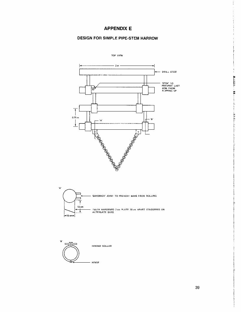
APPENDIX E
DESIGN FOR SIMPLE PIPE-STEM HARROW
TOP VIEW
1•.-------- 2 m ----------1
-j L..-.-,--,-l
0.75m
1
DRILL STEM
'STOP'TOPR EVENT LASTROW FROMFLIPPING UP
'A'
~'SANDWICH' JOINT TO PREVENT BARS FROM ROLLING
12cm• + TEETH HARDEr.ED 2 em PLATE 20 em APART STAGGERED ON
1 - t ALTERNATE BARS
f.10em..l-
'0 HINGED COLLAR
HINGE
39

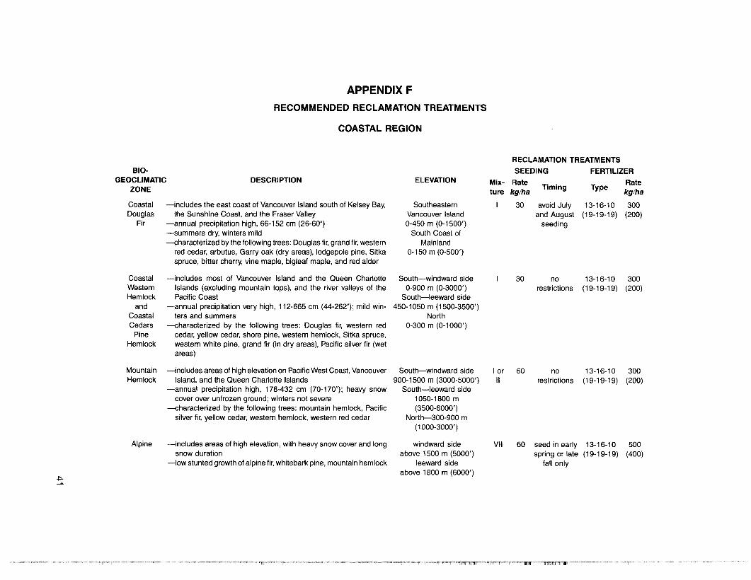
APPENDIX F
RECOMMENDED RECLAMATION TREATMENTS
COASTAL REGION
BIOGEOCLIMATIC
ZONE
CoastalDouglas
Fir
DESCRIPTION
-includes the east coast of Vancouver Island south of Kelsey Bay,the Sunshine Coast, and the Fraser Valley
-annual precipitation high, 66-152 cm (26-60")-summers dry, winters mild-characterized by the following trees: Douglas fir, grand fir, western
red cedar, arbutus, Garry oak (dry areas), lodgepole pine, Sitkaspruce, bitter cherry, vine maple, bigleaf maple, and red alder
ELEVATION
SoutheasternVancouver Island0-450 m (0-1500')
South Coast ofMainland
0-150 m (0-500')
RECLAMATION TREATMENTS
SEEDING FERTILIZER
Mix- Rate .. Rateture kg/ha Timing Type kg/ha
30 avoid July 13-16-10 300and August (19-19-19) (200)
seeding
CoastalWesternHemlock
andCoastalCedars
PineHemlock
MountainHemlock
-includes most of Vancouver Island and the Queen CharlotteIslands (excluding mountain tops), and the river valleys of thePacific Coast
-annual precipitation very high, 112-665 cm (44-262"); mild winters and summers
-characterized by the following trees: Douglas fir, western redcedar, yellow cedar, shore pine, western hemlock, Sitka spruce,western white pine, grand fir (in dry areas), Pacific silver fir (wetareas)
-includes areas of high elevation on Pacific West Coast, VancouverIsland, and the Queen Charlotte Islands
-annual precipitation high, 178-432 cm (70-170"); heavy snowcover over unfrozen ground; winters not severe
-characterized by the following trees: mountain hemlock, Pacificsilver fir, yellow cedar, western hemlock, western red cedar
South-windward side0-900 m (0-3000')
South-leeward side450-1050 m (1500-3500')
North0-300 m (0-1000')
South-windward side900-1500 m (3000-5000')
South-leeward side1050-1800 m(3500-6000')
North-300-900 m(1000-3000' )
lorII
30
60
norestrictions
norestrictions
13-16-10 300(19-19-19) (200)
13-16-10 300(19-19-19) (200)
.j::.-"
Alpine -includes areas of high elevation, with heavy snow cover and longsnow duration
-low stunted growth of alpine fir, whitebark pine, mountain hemlock
windward sideabove 1500 m (5000')
leeward sideabove 1800 m (6000')
VII 60 seed in early 13-16-10 500spring or late (19-19-19) (400)
fall only
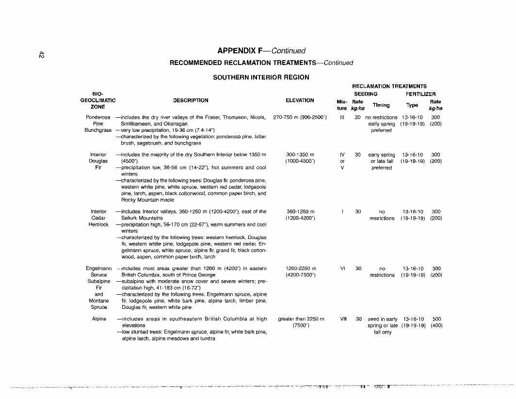
.j::>. APPENDIX F-ContinuedI\)
RECOMMENDED RECLAMATION TREATMENTS-Continued
SOUTHERN INTERIOR REGIONRECLAMATION TREATMENTS
BIO- SEEDING FERTILIZERGEOCLIMATIC DESCRIPTION ELEVATION Mix- Rate Rate
ZONE ture kg/haTiming Type
kg/ha
Ponderosa -includes the dry river valleys of the Fraser, Thompson, Nicola, 270-750 m (900-2500') III 30 no restrictions 13-16-1 0 300Pine Similkameen, and Okanagan early spring (19-19-19) (200)
Bunchgrass -very low precipitation, 19-36 cm (7.4-14") preferred-characterized by the following vegetation: ponderosa pine, bitter
brush, sagebrush, and bunchgrass
Interior -includes the majority of the dry Southern Interior below 1350 m 300-1350 m IV 30 early spring 13-16-10 300Douglas (4500') (1000-4500') or or late fall (19-19-19) (200)
Fir -precipitation low, 36-56 cm (14-22"), hot summers and cool V preferredwinters
-characterized by the following trees: Douglas fir, ponderosa pine,western white pine, white spruce, western red cedar, lodgepolepine, larch, aspen, black cottonwood, common paper birch, andRocky Mountain maple
Interior -includes Interior valleys, 360-1260 m (1200-4200'), east of the 360-1260 m I 30 no 13-16-10 300Cedar Selkirk Mountains (1200-4200') restrictions (19-19-19) (200)
Hemlock -precipitation high, 56-170 cm (22-67"), warm summers and coolwinters
-characterized by the folloWing trees: western hemlock, Douglasfir, western white pine, lodgepole pine, western red cedar, En-gelmann spruce, white spruce, alpine fir, grand fir, black cotton-wood, aspen, common paper birch, larch
Engelmann -includes most areas greater than 1260 m (4200') in eastern 1260-2250 m VI 30 no 13-16-10 300Spruce British Columbia, south of Prince George (4200-7500') restrictions (19-19-19) (200)
Subalpine -subalpine with moderate snow cover and severe winters; pre-Fir cipitation high, 41-183 cm (16-72")and -characterized by the following trees: Engelmann spruce, alpine
Montane fir, lodgepole pine, white bark pine, alpine larch, limber pine,Spruce Douglas fir, western white pine
Alpine -includes areas in southeastern British Columbia at high greater than 2250 m VII 30 seed in early 13-16-10 500elevations (7500') spring or late (19-19-19) (400)
-low stunted trees: Engelmann spruce, alpine fir, white bark pine, fall onlyalpine larch, alpine meadows and tundra
APPENDIX F-ContinuedRECOMMENDED RECLAMATION TREATMENTS-Continued
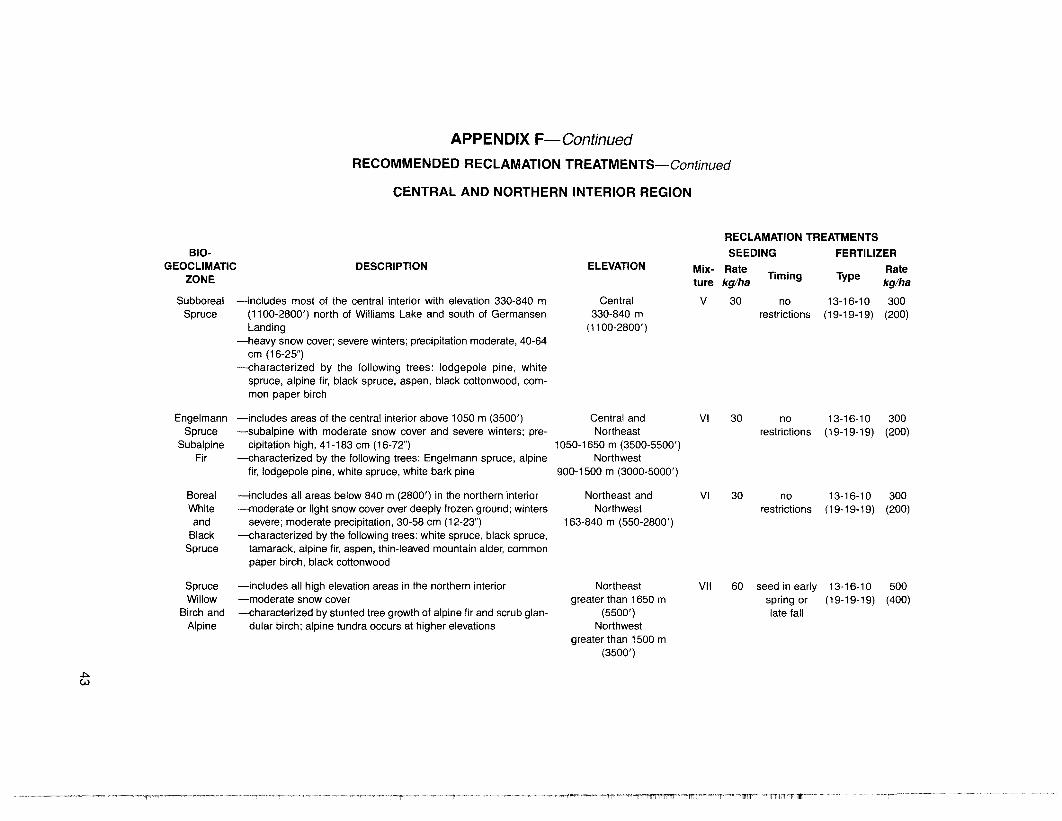
CENTRAL AND NORTHERN INTERIOR REGION
810GEOCLIMATIC
ZONE
SubborealSpruce
DESCRIPTION
-includes most of the central interior with elevation 330-840 m(1100-2800') north of Williams Lake and south of GermansenLanding
-heavy snow cover; severe winters; precipitation moderate, 40-64cm (16-25")
-characterized by the following trees: lodgepole pine, whitespruce, alpine fir, black spruce, aspen, black cottonwood, common paper birch
ELEVATION
Central330-840 m
(1100-2800' )
Mixture
v
RECLAMATION TREATMENTS
SEEDING FERTILIZER
Rate .. Ratekg/ha Timing Type kg/ha
30 no 13-16-1 0 300restrictions (19-19-19) (200)
EngelmannSpruce
SubalpineFir
BorealWhiteand
BlackSpruce
-includes areas of the central interior above 1050 m (3500')-subalpine with moderate snow cover and severe winters; pre-
cipitation high, 41-183 cm (16-72")-characterized by the following trees: Engelmann spruce, alpine
fir, lodgepole pine, white spruce, white bark pine
-includes all areas below 840 m (2800') in the northern interior-moderate or light snow cover over deeply frozen ground; winters
severe; moderate precipitation, 30-58 cm (12-23")-characterized by the following trees: white spruce, black spruce,
tamarack, alpine fir, aspen, thin-leaved mountain alder, commonpaper birch, black cottonwood
Central andNortheast
1050-1650 m (3500-5500')Northwest
900-1500 m (3000-5000')
Northeast andNorthwest
163-840 m (550-2800')
VI
VI
30
30
norestrictions
norestrictions
13-16-10 300(19-19-19) (200)
13-16-10 300(19-19-19) (200)
~c.v
SpruceWillow
Birch andAlpine
-includes all high elevation areas in the northern interior-moderate snow cover-characterized by stunted tree growth of alpine fir and scrub glan-
dular birch; alpine tundra occurs at higher elevations
Northeastgreater than 1650 m
(5500')Northwest
greater than 1500 m(3500')
VII 60 seed in earlyspring orlate fall
13-16-10 500(19-19-19) (400)

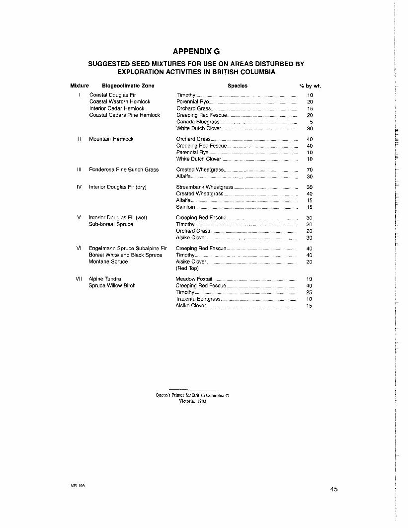
APPENDIX GSUGGESTED SEED MIXTURES FOR USE ON AREAS DISTURBED BY
EXPLORATION ACTIVITIES IN BRITISH COLUMBIA
IV Interior Douglas Fir (dry)
V Interior Douglas Fir (wet)Sub-boreal Spruce
VI Engelmann Spruce Subalpine FirBoreal White and Black SpruceMontane Spruce
% by wt.
10201520
530
40401010
7030
30401515
30202030
404020
Orchard Grass .Creeping Red FescuePerennial Rye .White Dutch Clover .
Crested Wheatgrass .Alfalfa
Creeping Red Fescue .....Timothy .Alsike Clover .(Red Top)
Timothy .Perennial Rye .Orchard Grass .Creeping Red Fescue ...Canada Bluegrass .White Dutch Clover .
Creeping Red Fescue ...Timothy .Orchard Grass... . ..Alsike Clover .. . .
Streambank Wheatgrass ...Crested Wheatgrass .Alfalfa .Sainfoin ..
Species
Ponderosa Pine Bunch Grass
Mountain HemlockII
III
Mixture Biogeoclimatic Zone
Coastal Douglas FirCoastal Western HemlockInterior Cedar HemlockCoastal Cedars Pine Hemlock
VII Alpine TundraSpruce Willow Birch
Meadow FoxtailCreeping Red FescueTimothy .Tracenta Bentgrass ...Alsike Clover ..
1040251015
Queen's Printer for British Columbia ©Victoria, 1983
MR-19545
Queen's Printer for British ColumbiaVictoria, J983