Embed Size (px)
Citation preview
1
DENR ADMINISTRATIVE ORDER NO. 2001 – 17 June 13, 2001 Subject : GUIDELINES FOR DELINEATING / DELIMITING
MUNICIPAL WATER
Pursuant to Article 1 on National Territory of the 1987 Constitution, Presidential Decree No. 1599 dated June 11, 1978, Section 123 of Republic Act 8550, otherwise known as the Philippine Fisheries Code of 1998, and Executive Order No. 192 dated June 10, 1987, the following regulations and guidelines governing the delineation and delimitation of municipal waters of the country are hereby promulgated:
Section 1. Basic Policy It is the policy of the State to protect the rights of the people, especially the local communities with priority to marginal fisherfolks, in the preferential use of the municipal waters. The delineation/delimitation of municipal waters will define the geographic extent of the city or municipality’s taxation or revenue-generating powers, its law enforcement jurisdiction, resource allocation, and general management powers. Section 2. Definition of Terms For the purpose of this manual, the following definition of terms shall be used: Adjacent municipalities – coastal municipalities sharing a common land boundary point on the coast Archipelago – a group of islands, including parts of islands, interconnecting waters and other natural features which are so closely related that such islands, waters, and other features form an intrinsic geographical, economic and political entity, or which historically have been regarded as such Awash – flush with or wash by waves
2
Baseline – the line from which the outer limits of municipal waters are projected Basepoint – a point on land from which baselines are drawn Cay – a low, flat island of sand, coral, or other material which is awash or dries during low water Coast – the edge or margin of land next to the sea Coastal terminal point – a boundary point on the coast, common to two adjacent municipalities Coastline – the line where the shore and water meet Construction line – a temporary drawing line used in determining a final line, e.g., a boundary line, or points used to determine that final line Delimitation – the determination of boundaries of municipal waters between adjacent or opposite municipalities where the delineation of their respective waters shows that their respective municipal waters overlap Delineation – the determination of the outer limits of the municipal waters of a municipality Drying reef – a reef or part of it which dries at low tide Fringing reef – a reef directly attached to the shore or located in its immediate vicinity General coastline of the municipality – refers to the coastline of the mainland and offshore and/or fringing islands of the municipality High water or high tide – refers to the highest level reached at a place by the water surface in one oscillation Island – a naturally formed area of land, surrounded by water, provided that where the island is surrounded by the sea, the same should always be above the water at high tide
3
Lateral boundary – the municipal water boundary between two adjacent municipalities Low water or low tide – refers to lowest level reached at a place by the water surface in one oscillation Low water line or low water mark – the intersection of the plane of low water with the shore; the line along a coast or beach to which the sea recedes at low water Mainland of the city or municipality – the land area of the municipality within which the municipal capitol is located Median line or equidistance line – a line every point of which is equidistant from the nearest points on the coasts of two municipalities Municipal archipelagic baseline – a baseline used in cases where the municipality is composed of islands or has offshore and/or fringing islands Normal baseline – the baseline described by the coastline of a municipality, where such coastline is relatively smooth and simple and there are no outlying of fringing islands, reefs, rocks, pinnacles or other abutting features Opposite municipalities – municipalities not sharing land boundaries but having coastlines which face each other and are less than thirty (3) kilometers apart Pirate rock – a sharp pointed rock rising from the bottom, which may extend above the surface of the water Reef – a mass of rock or coral which either reaches close to the sea surface or is exposed at low tide Rock – a formation of natural origin that constitutes an integral part of the lithosphere, which may or may not always be above high tide Sandbar – a shallow portion of the coast, largely made of loose sand that is near the surface of the water
4
Shoal – an offshore hazard to navigation on which there is a depth of ten (10) fathoms or twenty (20) meters or less, composed of unconsolidated material except coral or rock Straight baseline – a baseline used in cases where the coastline is deeply indented or cut into Tidal water – any water the level of which changes periodically due to tidal action Section 3. Coverage The coverage of this administrative order shall be all the municipal waters as defined by Sec. 4(58) of RA 8550, which include, not only streams, lakes, inland bodies of water and tidal waters within the municipality which are not included within the protected areas as defined under RA 7586 (The NIPAS Law), public forest, timber lands, forest reserves or fishery reserves, nut also marine waters included between two (2) lines drawn perpendicular to the general coastline from points where the boundary lines of the municipality touch the sea at low tide and a third line parallel with the general coastline including offshore islands and fifteen (15) kilometers from such coastline. Where two (2) municipalities are situated on opposite shores that there is less than thirty (30) kilometers of marine waters between them, the third line shall be equally distant from opposite shore of the respective municipalities. This administrative order shall not be construed to preclude special agencies or offices in exercising their jurisdiction over municipal waters by virtue of special laws creating these agencies such as, but not limited to, the Laguna Lake Development Authority and the Palawan Council for Sustainable Development, pursuant to Sec. 17 of RA 8550. Section 4. Role/Responsibility of Agencies
In order to have an efficient and effective flow of activities in the delineation/ delimitation of municipal waters, the role of the agencies involved are herein provided:
A. Department of Environment and Natural Resources (DENR)
1. As the mother agency, oversee the activities being conducted by NAMRIA;
5
2. Provide the implementation mechanism for the delineation/delimitation;
3. Provide assistance/support and participate in the conduct of public hearing through its field offices, units, agencies, programs, and projects.
B. National Mapping and Resource Information Authority
(NAMRIA) 1. Delineate or delimit the boundaries of municipal waters on
maps or charts of appropriate scale as requested by the local government units;
2. Provide the local government units proposed maps and technical descriptions of the maps before the conduct of the public hearing;
3. Approve the maps, charts, and technical descriptions as a result of the delineation/delimitation of municipal waters;
4. Participate in public hearings and consultations conducted in relation to the delineation/delimitation of municipal waters and take note of comments, inputs, suggestions, reactions or objections to the proposed delineation/delimitation;
5. Revise maps, charts, or technical descriptions as a result of the public hearing;
6. Approve an official copy of maps, charts, and technical descriptions and provide the approved maps to the municipality/city concerned;
7. Provide technical assistance relevant to the delineation and delimitation of municipal waters;
8. Act as the repository of all technical descriptions and corresponding original maps or charts of all municipal waters;
9. Conduct actual verification of boundary limits as required.
C. Local Government Units 1. Request the NAMRIA to delineate/delimit the boundaries
of their municipal waters; 2. Conduct public hearings arid consultations in relation to
the proposed delineation/delimitation; 3. Settle disputes with adjacent or opposite municipalities
arising from the delineation/delimitation through the Sangguniang Bayan/ Panlungsod or Panlalawigan or in any appropriate body;
6
4. Enact ordinances setting forth the extent of its municipal waters, incorporating thereof the maps or charts and technical descriptions.
D. Other Agencies and/or Entities
Other agencies and/or entities that are involved in the management and development of municipal waters should assist in the delineation/delimitation of municipal waters. Information (map, technical descriptions, etc.) of areas under their administrative jurisdiction should be provided.
Section 5. Systems and Procedures A. Requirements to Start Delineation Process
1. Filing of Request for Delineation All requests for delineation and delimitation of municipal
waters shall be directed to the Administrator of the NAMRIA, through the Director of the Coast and Geodetic Survey Department.
A request may be made by any of the following:
a) a city or municipality individually or jointly with other cities/municipalities with whom common boundaries are shared, through a resolution of the Sangguniang Panglungsod or Sangguniang Bayan;
b) a province on behalf of all its coastal municipalities, through a resolution of the Sangguniang Panlalawigan;
c) a national government agency on behalf of any city or municipality, through a formal letter/request signed by the head of the agency, but only with the conformity of the affected local government unit/s, expressed in form of a resolution of the Sanggunian concerned which shall be attached to the letter/request.
A copy of the resolution or letter/request shall be
furnished by the NAMRIA to: a) the DENR Community Environment and Natural
Resources Office (CENRO) and/or the relevant DENR Regional Office;
b) the BFAR; c) any adjacent or opposite municipality which may be
affected by the delineation and/or delimitation;
7
d) the Regional Office of the Philippine National Police Maritime Group (PNP-MARIG);
e) any special agency having jurisdiction over coastal waters which may be excluded from municipal waters in accordance with the Fisheries’ Code (e.g. the Protected Area Management Board (PAMB) with respect to areas under the NIPAS Act);
f) any affected private parties or sectors which the city or municipality may deem fit to notify.
2. Basic Technical Requirements for Requesting Entity
The filing of request for delineation must include basic technical requirements such as: a) a list of known or named islands and maps of said islands
under the jurisdiction of the municipality whose municipal waters are to be delineated and delimited; and
b) a copy of the legislation/proclamation creating the municipality or city.
3. Response
The NAMRIA through the Director of the Coast and Geodetic Survey Department shall schedule the delineation and delimitation of the municipal waters of the municipality. A copy of the response shall also be furnished to any adjacent or opposite municipality, which may be affected by the delineation and/or delimitation.
B. Procedure for Delineation and Delimitation of Municipal Waters
1. Delineation of Municipal Waters a) Use of normal baselines
i. Where the coastline is not deeply indented or cut into, and there are no outlying or fringing islands, reefs, or rocks, the normal baseline shall be the low water line.
ii. The normal baseline shall determine the general coastline of the municipality for purposes of delineation and delimitation.
iii. The outer limits of the municipal waters of the municipality shall be determined by a line parallel to the normal baselines and fifteen (15) kilometers therefrom.
b) Use of straight baselines
8
i. Where the coastline is deeply indented and/or there are outlying or fringing reefs or rocks, the outermost points of the coastline may be connected by straight baselines, provided that the length of such baselines does not exceed thirty (30) kilometers.
ii. In such cases the straight baselines shall determine the general coastline of the municipality for purposes of delineation and delimitation.
iii. Reefs, rocks, cays, shoats, sandbars, and any other features which are submerged during high tide shall not be used as basepoints. Neither shall they have their own coastlines.
iv. The outer limits of the municipal waters of the municipality shall be determined by a line parallel to the straight baselines and fifteen (15) kilometers therefrom.
c) Use of Municipal archipelagic baselines
i. Where the territory of a municipality includes several islands, the outermost points of such islands shall be used as basepoints and connected by municipal archipelagic baselines, provided that the length of such baselines shall not exceed thrity (3) kilometers.
ii. The municipal archipelagic baselines shall determine the general coastline of the municipality for purposes of delineation and delimitation.
iii. Islands, isles, or islets located more than thirty (30) kilometers from the mainland of the municipality shall have their own separate coastlines.
iv. Rocks, reefs, cays, shoals, sandbars, and other features which are submerged during high tide shall not be used as basepoints for municipal archipelagic baselines. Neither shall they have their own coastlines.
v. The outer limits of the municipal waters of the municipality shall be enclosed by a line parallel to the municipal archipelagic baselines and fifteen (15) kilometers therefrom.
d) Combination of baselines
A combination of normal and straight baselines, or normal and municipal archipelagic baselines, may be used depending on the circumstances and in the interest of simplicity in determining the general coastline and delineating municipal waters.
9
2. Delimitation of Adjacent Municipal Waters
a) Where the general coastline is not curved or irregularly shaped at the coastal terminal point of the land boundary common to two (2) adjacent municipalities, the lateral boundary shall be determined by a line perpendicular to the general coastline at the terminal point.
b) Where the general coastline at the point where the land boundary touches the sea is curved or irregularly shaped, making the determination of a perpendicular line impossible, the lateral boundary between two (2) adjacent municipalities may be determined by either of the following methods, depending on the complexity of the coastline:
i. Simplified bisection
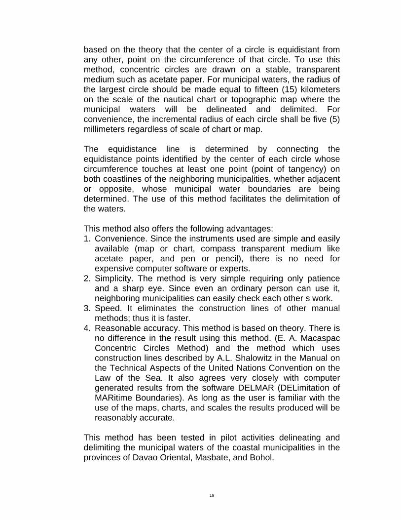
The lateral boundary shall be determined as follows: i.a)Examine the direction of the general coastline on
both sides of the common coastal terminal point. On each side of the common point, draw a straight line, a short baseline, whose length shall be limited to the point where the direction of the general coastline changes significantly or veers to another quadrant (see Fig. 1 for illustration).
i.b)Draw perpendicular lines to the coastlines on both sides of the common terminal point, passing through this common terminal point. Bisect the angle formed by the two perpendicular lines. 1'he bisector is the lateral boundary of the municipal waters between the adjacent municipalities. The bisector will extend to fifteen (15) kilometers if the coastlines beyond the short baselines will no longer affect its equidistance from both coastlines; otherwise, it will extend only up to a distance beyond which the equidistance line method shall already be applied (see Fig. 1 for illustration).
ii. Equidistance line
The lateral boundary shall be determined by a line equidistant from the coastlines of the adjacent municipalities, as determined through the use of the baselines under Paragraphs 1a through 1d of Section 5B.
10
3. Determination of Opposite Municipal Waters
In the case of opposite municipalities which are less than thirty (30) kilometers apart, the municipal water boundaries between them shall be determined by the median or equidistance line between the general coastlines of the respective municipalities, as determined through the use of the baselines under Paragraphs 1a through 1d of Section 5B.
4. Delimitation of Municipal Waters of Three or More Adjacent
and Opposite Municipalities In cases where three or more municipalities are so
situated that they have overlapping municipal waters, the delimitation of the lateral and offshore boundaries of their municipal waters shall be determined by the equidistance line method. The lateral boundaries will usually end at a point which is common to three or more municipalities, at the offshore boundary.
5. Municipal Water Boundary Delimitation Prior to Republic Act
No. 8550 Where two municipalities have actually delimited the
boundaries of their municipal waters prior to the enactment of Republic Act No. 8550 in 1998, in accordance with the law prevailing at the time, and pursuant to the procedure prescribed therein, such previous boundary delimitation shall be respected and given effect as far as may be practicable in the light of the provisions of the Fisheries Code of 1998 and the application of the guidelines in this manual in order to respect prior vested rights.
6. Finalization Only After Approval
The technical description of municipal waters shall be deemed final only after the boundaries of municipal waters have been duly approved by the concerned city of municipality as evidenced by a final and executory ordinance embodying the same. Each boundary corner common to two (2) adjacent or opposite municipalities shall have exactly the same geographic position.
7. Depth Curve
11
Where practicable, the seven (7) fathom depth curve within the municipal waters shall be clearly indicated on the charts provided by the NAMRIA.
8. Demarcation of Marine Reserves, Sanctuaries, or Other
Special Areas If within or overlapping with the municipal waters, there is
a marine reserve sanctuary, or other special area under the exclusive jurisdiction of an entity other than the municipality, a clearance shall be obtained by the NAMRIA from said entity prior to the inclusion of the boundaries of such reserve, sanctuary, or special area, or such part thereof which overlaps with the municipal waters so as to effectively exclude the same from the computation of the area of municipal waters. Provided that the protected seascape or marine reserve area shall be managed by local government according to the mandate and responsibilities as provided in the NIPAS Law. Nothing in this provision shall prevent the National Government from declaring any portion of municipal waters as Protected Areas or Marine Reserves.
C. Publication and Public Hearing
1. Public Hearing The NAMRIA shall submit to the requesting city or
municipality a preliminary delineation of the municipal waters, and delimitation thereof with respect to any adjacent or opposite municipality, drawn on maps or charts of appropriate scale, and accompanied by a technical description. Such delineation and/or delimitation shall be in accordance with the technical guidelines set forth in Section 5B hereof.
The requesting city or municipality shall cause the
publication of the map or chart clearly showing the delineation and/or delimitation of municipal waters, through a) posting in prominent places in the city or municipality; b) dissemination of copies of the same to all the component
barangays; and c) furnishing copies, through regular channels, to any cities
or municipalities affected.
12
In accordance with regular processes and practices, the requesting city or municipality shall conduct the same for public hearing and consultation for the purpose of receiving comments, inputs suggestions reactions, or objections to the proposed delineation and/or delimitation. The NAMRIA shall be present at the public hearing to document and consider such comments, inputs, suggestions, reactions, or objections.
Adjacent or opposite municipalities may if they so decide
for purposes of convenience and practicality, jointly hold the public hearings.
2. Disputes with Adjacent or Opposite Municipalities
If adjacent or opposite municipalities, as well as agencies having jurisdiction over defined coastal waters, or any interested parties, raised any objection to the preliminary delineation and/or delimitation of municipal waters, such objection shall be made in writing, in the form of a Resolution of the Sangguniang Bayan or Panglungsod concerned, or an official letter from, the responsible officer or person, and officially presented at public hearing.
a) Amicable Settlement Encouraged
In case of boundary conflict, this guideline shall not prevent the municipalities concerned from negotiating or mutually agreeing to a common municipal water boundaries provided there is substantial compliance with the provisions of the law. Such negotiated boundaries shall be submitted to the NAMRIA for verification. The NAMRIA may also provide technical assistance and advice to the municipalities in the course of their negotiations.
The delimitation of municipal water boundaries in accordance with a negotiated settlement shall be certified by the NAMRIA prior to its finalization and submission for enactment as an ordinance.
Certification of such negotiated boundaries shall not be denied under normal circumstances.
b) Irreconcilable Differences
In case the municipalities cannot settle their differences amicably through negotiation, and the differences are
13
based on the proper application of technical rules and guidelines, they shall jointly submit the issue to the NAMRIA for decision. The NAMRIA shall inform the Municipalities within thirty (30) days from the submission of the issue.
c) Dispute Before Other Fora
Where the time of the delineation and/or delimitation of the dispute is pending before another forum on account of substantial issues that go beyond the application of technical rules and guidelines (e.g., when there is a pending case before a regular court over ownership and/or jurisdiction over islands or other features), the NAMRIA may, in the meantime, delineate and determine the temporary municipal water boundaries between the contesting municipalities, without considering the contested islands or features provided that the affected municipalities agree to such temporary delimitation, provided further that the temporary delimitation shall be subject to the outcome of the dispute as determined by the concerned forum.
D. Revision and Finalization
1. Certification of Final Map The NAMRIA, after considering the inputs from the public
hearing, or the outcome of the dispute settlement mechanisms set forth in Paragraph 2 of Section 5C, shall revise the delineation and/or delimitation, and within thirty (30) days from the date of the last public hearing, or last meeting under Paragraph 1 of Section 5C, provide an official copy of the revised maps, charts, and technical descriptions to the requesting city or municipality. Such maps, charts, and technical description shall be duly certified by the NAMRIA Administrator as comprising the final and definitive delineation and/or delimitation of municipal waters.
2. Enactment of Ordinance
After the receipt of the revised and certified delineation or delimitation, if any, or of the date of the last public hearing if no revision was necessary, the requesting city or municipality shall enact an ordinance setting forth the extent of its municipal waters, incorporating the maps, charts, or technical descriptions prepared and approved by NAMRIA.
14
Once the ordinance has become final and executory, the
original copy must be submitted to the NAMRIA and official copies thereof shall be provided to the following:
a) any adjacent or opposite municipalities affected by the delimitation;
b) the BFAR; c) the Regional Office of the PNP-MARIG; d) any concerned special agency having jurisdiction over
coastal waters which may be excluded from municipal waters;
e) any affected party or sector the city or municipality may deem fit to notify;
f) the DENR field office.
3. Repository Function The NAMRIA shall be the repository of all technical
descriptions and corresponding maps or charts of all municipal waters. An official copy of such technical descriptions and maps or charts shall be provided to the municipality concerned.
Section 6. Fees and Costs
For the delineation of municipal waters that would be conducted by NAMRIA, each city/municipality shall be charged with a service fee of PhP 5,000.00 plus PhP 50.00 per kilometer of coastline of the municipality exclusive of field expenses. NAMRIA shall likewise charge a verification fee of PhP 5,000.00 wherever applicable.
Section 7. Transitory Provision
These guidelines shall be immediately effective in delineating municipal waters in all cities and municipalities except those which have offshore islands or islets for which the delineation process shall start six (6) months from the effectivity of these guidelines. Section 8. Repealing Clause
All orders rules and regulations inconsistent with or contrary to the provisions of these Guidelines are hereby repealed or modified accordingly.
15
Section 9. Effectivity This Administration Order shall take effect fifteen (15) days after
its publication in newspaper of general circulation.
(Sgd.) HEHERSON T. ALVAREZ
Secretary
16
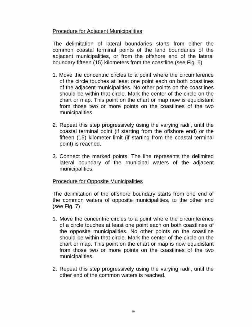
TECHNICAL ANNEX METHODS/PROCEDURES FOR DELINEATING MUNICIPAL WATERS A. USING NORMAL BASELINES The normal baseline is the baseline described by the coastline of a city or municipality, where such a coastline is relatively smooth and simple and there are no outlying or fringing islands, reefs, rocks, pinnacles, or other abutting features (see Fig. 2)
1. Using fifteen 15) kilometers (on a scale of the chart or map where the municipal waters will be delineated) as radius and a point on the coastline at low tide as center of circle, draw arcs of circles from different points on the coastline of the municipality. Allow these arcs to intersect.
2. Select the outermost arcs that have been drawn. These arcs form the offshore limit of the municipal waters. Note that not all points along the coastline contribute to the delineation of this offshore limit. Usually, only the protruding points of the coastline do count and have the most impact.
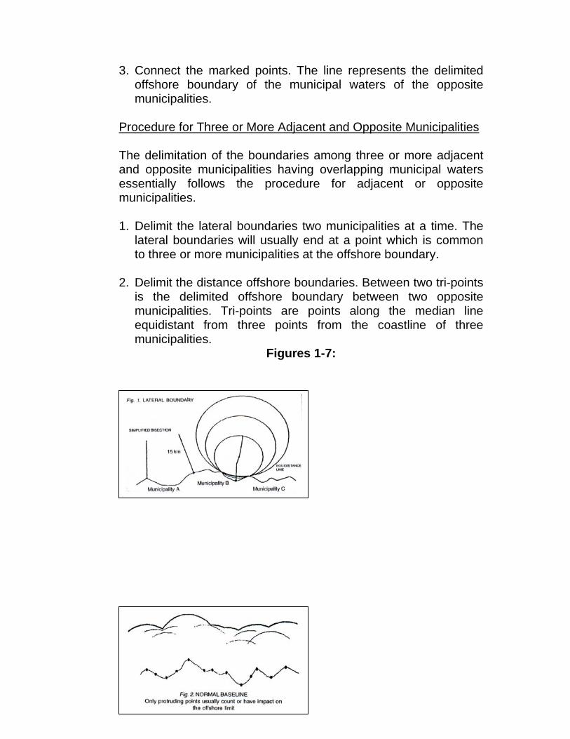
B. USING STRAIGHT BASELINES A straight baseline is the baseline used in cases where the coastline is deeply indented or cut into (see Fig. 3)
1. Join protruding points along the coastline by straight lines, the length of which should not exceed thirty (30) kilometers.
2. Draw perpendicular lines passing through the basepoints of each baseline.
17
3. Form the basepoints, measure fifteen 15 kilometers offshore along the perpendicular lines. Connect the offshore points on the perpendiculars of each baseline. The line joining these offshore points is parallel to the baseline.
4a.When the exterior angle formed by two consecutive baselines is more than 180 degree, draw an arc of circle, using fifteen (15) kilometers as radius and the common basepoint of the two baselines as center of circle, from one perpendicular to the other perpendicular. The offshore limit of the municipal waters, measured from these two baselines, is the line consisting of the arc and the two parallel lines.
4b. When the exterior angle formed by two consecutive baselines is less than 180 degree, no arc of circle is drawn. The offshore limit of the municipal waters, measured from these two baselines, is the line consisting of the intersecting two parallel lines.
5. The offshore limit of the entire municipal waters consists of the lines determined in the (4a) and (4b).
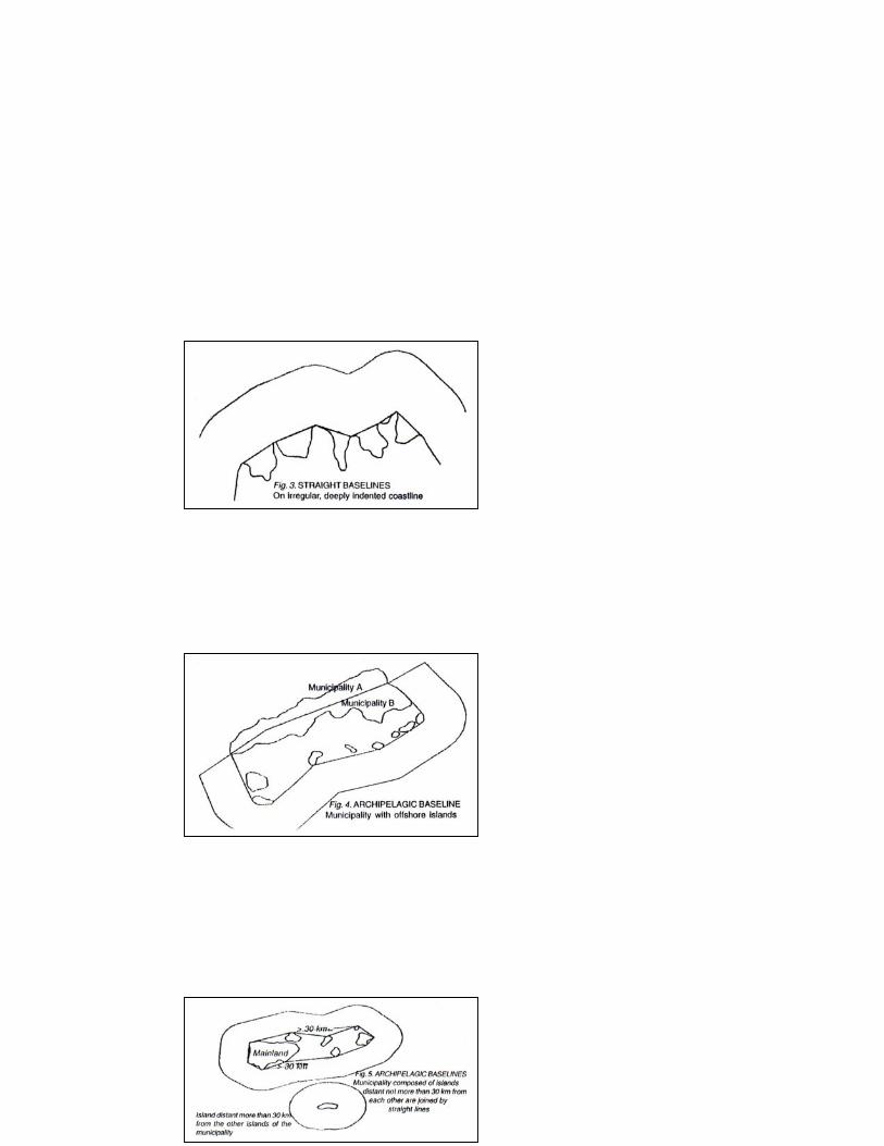
C. USING ARCHIPELAGIC BASELINES Archipelagic baselines are straight lines joining the outermost points of islands of a municipality.
1. Municipality with offshore islands Join the outermost points of the municipality by straight lines, beginning from the coastal terminal point (a boundary point on the coast, common to two municipalities) on the mainland of the municipality; then to the outermost islands; then to the other coastal terminal point of the municipality, provided that the length of each line shall not exceed thirty (30) kilometers; provided further that an isolated island of the municipality, if any, distant more than thirty (30) kilometers from any of the other islands of the municipality, shall generate its own municipal waters. More than one point on an Island can be used as basepoint (see Fig. 4)
2. Municipality composed of islands
a. Join the outermost points of the outermost islands by straight lines provided further than the length of each line shall not exceed thirty (30), kilometers; provided further than an isolated island of the municipality, if any, distant more than thirty (30) kilometers from any of the other islands of the municipality, shall generate (is own municipal waters.
18
More than one point on an island can be used as basepoint (see Fig. 5) Common to 1 and 2
b. Draw perpendicular lines passing through the basepoints of each baseline.
c. From the basepoints, measure fifteen (15) kilometers offshore along the perpendicular lines. Connect the offshore points on the perpendiculars of each baseline. The line joining these offshore points is parallel to the baseline.
d1.When the exterior angle formed by two consecutive baselines is more than 180 degrees draw an arc of circle, using fifteen (15) kilometers as radius and the common basepoint of the two baselines as a center of circle, from one perpendicular to the other perpendicular. The offshore limit of the municipal waters, measured from these two baselines, is the line consisting of the arc and the two parallel lines.
d2.When the exterior angle formed by two consecutive baselines is less than 180 degrees, no arc of circle is drawn. The offshore limit of the municipal waters, measured from these two baselines, is the line consisting of the intersecting two parallel lines.
e. The offshore limit of the entire municipal waters consists of the lines determined in (d1) and (d2).
MANUAL METHODS/PROCEDURES FOR DELIMITING MUNICIPAL WATERS
When the delineation of municipal waters of adjacent or opposite municipalities produce overlapping areas, it is necessary to delimit municipal waters in order to allocate the overlapping areas between the municipalities concerned. Considering the archipelagic nature of the country, and the many configurations of the Philippine coastline, it is very likely that the delimitation will be required by most coastal municipalities. In these cases, it is necessary to use a simple method of delimiting the municipal waters in a convenient and cost-effective manner. The Enrique A. Macaspac Concentric Circles Method of Determining an Equidistance Line in Boundary Delimitation. The Enrique A. Macaspac Concentric Circles Method of Determining an Equidistance Line in Boundary Delimitation is
19
based on the theory that the center of a circle is equidistant from any other, point on the circumference of that circle. To use this method, concentric circles are drawn on a stable, transparent medium such as acetate paper. For municipal waters, the radius of the largest circle should be made equal to fifteen (15) kilometers on the scale of the nautical chart or topographic map where the municipal waters will be delineated and delimited. For convenience, the incremental radius of each circle shall be five (5) millimeters regardless of scale of chart or map. The equidistance line is determined by connecting the equidistance points identified by the center of each circle whose circumference touches at least one point (point of tangency) on both coastlines of the neighboring municipalities, whether adjacent or opposite, whose municipal water boundaries are being determined. The use of this method facilitates the delimitation of the waters. This method also offers the following advantages: 1. Convenience. Since the instruments used are simple and easily
available (map or chart, compass transparent medium like acetate paper, and pen or pencil), there is no need for expensive computer software or experts.
2. Simplicity. The method is very simple requiring only patience and a sharp eye. Since even an ordinary person can use it, neighboring municipalities can easily check each other s work.
3. Speed. It eliminates the construction lines of other manual methods; thus it is faster.
4. Reasonable accuracy. This method is based on theory. There is no difference in the result using this method. (E. A. Macaspac Concentric Circles Method) and the method which uses construction lines described by A.L. Shalowitz in the Manual on the Technical Aspects of the United Nations Convention on the Law of the Sea. It also agrees very closely with computer generated results from the software DELMAR (DELimitation of MARitime Boundaries). As long as the user is familiar with the use of the maps, charts, and scales the results produced will be reasonably accurate.
This method has been tested in pilot activities delineating and delimiting the municipal waters of the coastal municipalities in the provinces of Davao Oriental, Masbate, and Bohol.
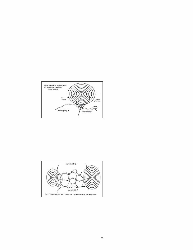
20
Procedure for Adjacent Municipalities The delimitation of lateral boundaries starts from either the common coastal terminal points of the land boundaries of the adjacent municipalities, or from the offshore end of the lateral boundary fifteen (15) kilometers from the coastline (see Fig. 6) 1. Move the concentric circles to a point where the circumference
of the circle touches at least one point each on both coastlines of the adjacent municipalities. No other points on the coastlines should be within that circle. Mark the center of the circle on the chart or map. This point on the chart or map now is equidistant from those two or more points on the coastlines of the two municipalities.
2. Repeat this step progressively using the varying radii, until the
coastal terminal point (if starting from the offshore end) or the fifteen (15) kilometer limit (if starting from the coastal terminal point) is reached.
3. Connect the marked points. The line represents the delimited
lateral boundary of the rnunicipal waters of the adjacent municipalities.
Procedure for Opposite Municipalities The delimitation of the offshore boundary starts from one end of the common waters of opposite municipalities, to the other end (see Fig. 7) 1. Move the concentric circles to a point where the circumference
of a circle touches at least one point each on both coastlines of the opposite municipalities. No other points on the coastline should be within that circle. Mark the center of the circle on the chart or map. This point on the chart or map is now equidistant from those two or more points on the coastlines of the two municipalities.
2. Repeat this step progressively using the varying radil, until the
other end of the common waters is reached.
21
3. Connect the marked points. The line represents the delimited offshore boundary of the municipal waters of the opposite municipalities.
Procedure for Three or More Adjacent and Opposite Municipalities The delimitation of the boundaries among three or more adjacent and opposite municipalities having overlapping municipal waters essentially follows the procedure for adjacent or opposite municipalities. 1. Delimit the lateral boundaries two municipalities at a time. The
lateral boundaries will usually end at a point which is common to three or more municipalities at the offshore boundary.
2. Delimit the distance offshore boundaries. Between two tri-points
is the delimited offshore boundary between two opposite municipalities. Tri-points are points along the median line equidistant from three points from the coastline of three municipalities.
Figures 1-7:
22
23