Embed Size (px)
Citation preview

GUIDELINES FOR
CONDUCTING ARCHAEOLOGY
IN VERMONT
2017
ii
ACKNOWLEDGEMENTS
Amending the Guidelines for Conducting Archaeology in Vermont (Guidelines) was a team
effort, headed by State Archaeologist, Jess Robinson, under the direction of State Historic
Preservation Officer, Laura V. Trieschmann, with insight and assistance from Vermont Division
for Historic Preservation (VDHP) archaeologists Scott Dillon and Yvonne Benney Basque.
These Guidelines update and supersede the previous version developed by the previous State
Archaeologist, Giovanna Peebles, and Scott Dillon. An advisory committee consisting of State
government, academic and non-profit archaeologists discussed many ideas and topics leading to
the development of a preliminary list of priority research questions important to understanding
the precontact and post-contact history of Vermont. The advisory committee also commented on
an earlier draft of the Guidelines. VDHP would like to thank all of the Vermont archaeologists
whose excavations, publications, and knowledge contributed to the reasoning behind these
guidelines.
Advisory Committee
Yvonne Benney Basque
John Crock, PhD
Jacob Clay
R. Scott Dillon
Brennan Gauthier
Dave Lacy
Jeannine Russell
John Vetter, PhD
Tim Watkins
iii
TABLE OF CONTENTS
ACKNOWLEDGEMENTS ............................................................................................................ ii
TABLE OF CONTENTS ............................................................................................................... iii
LIST OF FIGURES ...................................................................................................................... vii
INTRODUCTION .......................................................................................................................... 1
RELEVANT STATUTORY AUTHORITIES ............................................................................... 2
CRITERIA FOR QUALIFIED PROFESSIONAL ARCHAEOLOGISTS .................................... 3
SUBMITTAL PROCESS ............................................................................................................... 4
ARCHAEOLOGICAL INVESTIGATIONS: DOCUMENTATION PLAN ................................. 5
Research Design: All Phases ...................................................................................................... 5
Background Research ................................................................................................................. 6
Area of Potential Effects ......................................................................................................... 7
Consulting the Community and Knowledgeable Individuals ................................................. 8
Tools for Research Design .......................................................................................................... 8
Online Resource Center .......................................................................................................... 8
ORC Map Tool ....................................................................................................................... 8
Predictive Models for Precontact Sites: .................................................................................. 9
ARCHAEOLOGICAL RESOURCE ASSESSMENT ................................................................. 11
Field Inspection or Site Visit .................................................................................................... 12
Winter Limitations (ARA, SOW, and all Phases) ................................................................ 13
Defining Previous “Significant” Ground Disturbance .......................................................... 13
Map Documentation .................................................................................................................. 13
Photographic Documentation.................................................................................................... 14
ARA Report .............................................................................................................................. 14
SCOPE OF WORK ....................................................................................................................... 16
Preparing a Scope of Work ....................................................................................................... 16
VDHP Review of Scopes of Work ........................................................................................... 17
Collections Care and Management Issues in Scopes of Work ................................................. 17
Other Considerations ................................................................................................................ 18
Permits .................................................................................................................................. 18
Redaction (ARA, SOW, and all Phases). .............................................................................. 18
PHASE IA INVESTIGATION: RECONNAISSANCE ............................................................... 20

iv
Developing Alternative Predictive Models ............................................................................... 20
PHASE I INVESTIGATION: IDENTIFICATION Survey ......................................................... 22
Phase I Field Investigations ...................................................................................................... 22
Surface Survey .......................................................................................................................... 22
Recording measurements (all Phases). ................................................................................. 23
Ground Sensing Methods for Historic and Precontact Period Sites. .................................... 23
Treating Isolated, or Limited, Surface Artifacts. .................................................................. 23
Sub-Surface Testing .................................................................................................................. 24
Shovel test pit methodology.................................................................................................. 24
Test units ............................................................................................................................... 25
Deep testing .......................................................................................................................... 25
Treating Isolated, or Limited, Sub-Surface Artifacts ............................................................ 26
Precontact Feature Excavation Protocols .................................................................................. 26
Discovery and Treatment of Human Remains (All Phases) ..................................................... 26
Historic Site Discovery and Investigation ................................................................................ 27
Identifying important research questions and necessary data sets for Historic-era Sites ..... 27
Quality of site evidence ........................................................................................................ 27
Summary of Information Needed by VDHP to Determine if Historic Site Assessment
Process Should Continue ...................................................................................................... 27
Site Numbers and Acquiring Site Numbers for Newly Identified Archaeological Sites .......... 28
Data Generation and Analysis Guidance .................................................................................. 28
Reporting Identification Results ............................................................................................... 29
Phase I “End-of-Field” Letter ............................................................................................... 29
EOF Report ............................................................................................................................... 30
Vermont Archaeological Inventory (VAI) Form ...................................................................... 32
Phase I Investigation Report ..................................................................................................... 32
Additional Documentation ........................................................................................................ 33
Shapefiles (all phases)........................................................................................................... 33
Archival Photographs (all phases) ........................................................................................ 33
Collections Care and Management ........................................................................................... 34
PHASE II INVESTIGATION: EVALUATION STUDY ............................................................ 35
Research Design Requirements for Phase II Investigations ..................................................... 35
Field Investigations and Data Analyses .................................................................................... 35
Field Investigation for Historic-era Archaeological Sites .................................................... 36
Documenting results ................................................................................................................. 36
v
Special Considerations for Phase II End-of-Field Letter ...................................................... 36
Phase II Investigation Report .................................................................................................... 37
Collections Care and Management ........................................................................................... 37
Public Education and Outreach ................................................................................................. 38
EVALUATING SITE SIGNIFICANCE ...................................................................................... 39
National Register Criteria ......................................................................................................... 39
Historic Contexts ...................................................................................................................... 40
Integrity ..................................................................................................................................... 40
Establishing Precontact Site Significance ................................................................................. 41
The Site Must Be Able to Answer Specific, Detailed Questions Important to Understanding
Vermont Precontact and Contact Period History ...................................................................... 41
The Site Must Contain Multiple Categories of Data ................................................................ 43
Historic Site Significance ......................................................................................................... 43
Establishing Historic Period Site Significance ..................................................................... 44
Priority Research Topics to Help Evaluate Significance of Historic Period Sites ................... 45
Involving the Public .................................................................................................................. 46
PHASE III INVESTIGATION: DATA RECOVERY STUDY ................................................... 47
Additional Research Design Requirements for Phase III ......................................................... 47
Phase III Scope of Work ........................................................................................................... 47
Field Investigations and Data Analyses .................................................................................... 48
Documenting Results ................................................................................................................ 48
Avoidance and Mitigation Measures ........................................................................................ 49
Site Monitoring ......................................................................................................................... 49
Establishing a Permanent Site Datum ....................................................................................... 49
Capping Sites with Fill.............................................................................................................. 49
Phase III Investigation Reports ................................................................................................. 50
Standards for Phase III Reports ................................................................................................ 50
Management Summary and Recommendations .................................................................... 50
Conclusions ........................................................................................................................... 50
Education and Outreach ........................................................................................................ 51
Appendices ............................................................................................................................ 51
Special Considerations for Phase III Reports ........................................................................... 51
Quarterly, Semi-Annual or Annual Updates ......................................................................... 51
Public Education and Outreach ............................................................................................. 51
Collections Care and Management ....................................................................................... 52
vi
PUBLIC EDUCATION & OUTREACH ..................................................................................... 53
General Standards for Public Education and Outreach: ........................................................... 53
Education & Outreach for Landowners .................................................................................... 53
Education & Outreach for the Municipality ............................................................................. 54
Recommended Projects and Programs...................................................................................... 54
CARE AND MANAGEMENT OF ARCHAEOLOGICAL COLLECTIONS ............................ 57
If a Site is Located on Private Land .......................................................................................... 57
Vermont Archaeology Heritage Center .................................................................................... 58
Scope of the Collections ....................................................................................................... 58
Charges and Deeds of Gift .................................................................................................... 58
Native American Burials (Including Human Remains and Funerary Objects) and Non-
Native American Human Remains ....................................................................................... 59
Field Recovery, Sampling, and Culling/Discard Policies ..................................................... 59
APPENDIX I: SHAPEFILE REQUIREMENTS AND FORMATTING .................................... 61
Shapefile Submittal Requirements ............................................................................................ 61
Shapefile Formats and Appropriate Metadata .......................................................................... 61
Other Notes about Shapefile Submissions ................................................................................ 64
APPENDIX II: ACCIDENTAL DISCOVERY OF ARCHAEOLOGICAL SITES AFTER
PROJECT REVIEW AND/OR DURING PROJECT CONSTRUCTION .................................. 65
Procedure to follow when discoveries are made during Vermont Agency of Transportation
Projects:..................................................................................................................................... 65
Procedure to follow when discoveries are made in the course of Project Construction for Non-
VTrans Projects: ........................................................................................................................ 65
APPENDIX III: DEED OF GIFT FORM ..................................................................................... 66
vii
LIST OF FIGURES
Figure 1. Screenshot of the Vermont ORC map tool showing historic and precontact
archaeological sites. ........................................................................................................................ 9
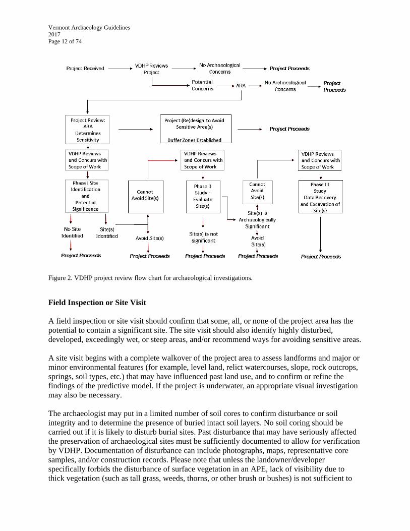
Figure 2. VDHP project review flow chart for archaeological investigations. ............................. 12
Figure 3. Map depicting LiDAR imagery of Mount Independence State Historic Site, Orwell,
Vermont, with select archaeological features indicated in red. .................................................... 15
Figure 4. VDHP archaeologist conducting a site visit within the Missisquoi National Wildlife
Refuge, Swanton, Vermont. .......................................................................................................... 21
Figure 5. Field technicians excavating Phase I test pits in South Burlington, Vermont.
Photograph courtesy of the University of Vermont Consulting Archaeology Program. .............. 24
Figure 6. Field technicians excavating deep test units along the Missisquoi River, Swanton,
Vermont. Photograph courtesy of Northeast Archaeology Research Center. .............................. 25
Figure 7. Underwater archaeological technician conducting measurements on a shipwreck, Lake
Champlain, Vermont. Photograph courtesy of Lake Champlain Maritime Museum. .................. 34
Figure 8. Phase II archaeological grid array in the Green Mountain National Forest, Warren,
Vermont. Photograph courtesy of David Lacy and the Green Mountain National Forest. .......... 38
Figure 9. Industrial Archaeologist Victor Rolando discussing with onlookers the Forestdale
Ironworks in the background, Brandon, Vermont. Photograph courtesy of David Lacy ............. 44
Figure 10. Field technician troweling a 1x 1 m unit within a Phase III block excavation, South
Burlington, Vermont. Photograph courtesy of the University of Vermont Consulting
Archaeology Program. .................................................................................................................. 52
Figure 11. Field technicians mapping a profile within a Phase III excavation block, Swanton,
Vermont. Photograph courtesy of the Northeast Archaeology Research Center. ......................... 52
Figure 12. Jess Robinson conducting a pottery workshop with families at the Montshire Museum
of Science during Vermont Archaeology Month. ......................................................................... 55
Figure 13. Interpretive Signage detailing the results of archaeological excavations at Chimney
Point, Addison, Vermont. ............................................................................................................. 56
Figure 14. Views of the Vermont Archaeology Heritage Center, Barre, Vermont. ..................... 60
Figure 15. Volunteers and temporary employees working at the Vermont Archaeology Heritage
Center. ........................................................................................................................................... 60
ABSTRACT
People have lived in Vermont for nearly 13,000 years. The vast majority of that history is
unwritten and is revealed only through archaeological investigations. Most of the archaeological
studies conducted in Vermont are undertaken in response to efforts restricted or directed by
federal and state laws designed to protect historic resources. The Vermont Division for Historic
Preservation (VDHP), serving as the Vermont State Historic Preservation Office (SHPO),
developed the Guidelines to provide a regulatory framework for those undertakings. VDHP
expects that they will also be used to guide non-regulatory archaeological studies as well. Since
the original drafting of the Guidelines in 1989, with a significant revision in 2002, years of
archaeological studies and significant advances in digital technology have provided an important
perspective for refining and improving the current practice of archaeology in Vermont and for
augmenting the guidance under which archaeological investigations are undertaken.
The Guidelines reflect various goals for the archaeological investigations undertaken in the State
of Vermont:
Ensure that archaeological studies meet high professional research standards.
Identify significant archaeological sites that can contribute to our understanding of
Vermont’s precontact and post-contact history.
Protect archaeological sites and gain information on them, as appropriate.
Preserve, protect, interpret and disseminate the data derived from archaeological studies,
as appropriate.
Provide significant public benefit.
Develop sound and reasoned public policies on regulatory archaeology.
Keep archaeological studies as cost effective as possible.
INTRODUCTION
The Guidelines are designed to provide technical standards for archaeological professionals,
federal and state agencies, private developers, researchers, and anyone else involved in
archaeology in Vermont. The Guidelines should be followed to ensure the State’s archaeology
goals are met and that archaeologists are maintaining appropriate compliance with federal and
state laws. Adherence to the Guidelines is required for those archaeologists working under the
auspices of a Programmatic Agreement (PA) with specific exceptions unique to each agreement.
VDHP reserves the right to refuse regulatory concurrence for any archaeological investigation
that does not adhere to the Guidelines unless explicitly exempted by VDHP.
VDHP is involved in two major project review categories:
1. Reviews in accordance with federal laws, primarily under Section 106 and Section 110 of
the National Historic Preservation Act; and
2. Reviews under state laws, primarily under Act 250, Section 248 (Public Service Board)
and 22 VSA 14, of the Vermont Statutes.
In complying with any state or federal law, there may be different requirements and procedures
based on the nature of the programs, agreements, and/or statutory authorities. Nevertheless, the
Guidelines remain largely applicable to any archaeological investigations conducted in Vermont.
The Guidelines incorporate the Secretary of the Interior's Standards and Guidelines for
Identification, Evaluation, and Archeological Documentation (Standards and Guidelines).
The Guidelines do not address regulatory reviews involving architectural components or
standing structures. Therefore, please keep in mind that archaeological studies may not fully
complete an applicant’s historic preservation obligations if a property contains historic standing
resources that may be moved, altered, or demolished. Moreover, these Guidelines do not
specifically address the methodologies typically employed during underwater archaeological
investigations. VDHP is working to provide specific methodological guidance for underwater
studies. When completed, it will be added as an appendix to this document.
Questions about what constitutes a site for the purposes of regulatory undertakings should be
directed to VDHP. Minimally, a site must be based upon field observations or collections and not
solely upon historic maps or similar documentation.

Vermont Archaeology Guidelines
2017
Page 2 of 74
RELEVANT STATUTORY AUTHORITIES
Archaeological studies in Vermont will generally result from compliance with one or more of the
following state and federal laws, regulations, and/or rules. This is not an exhaustive list as other
laws and regulations may occasionally be relevant.
1 VSA Chapter 5, Section 317 (20) (exempts archaeological site locations from the
“right-to-know” law).
10 VSA Chapter 151 (Act 250).
13 VSA Chapter 81, Sections 3761, 3764, and 3766 (protection of burial sites).
18 VSA Chapter 107, Sections 5201 and 5212 a and b (protection and care burial sites,
including unmarked burials).
22 VSA Chapter 14 (Vermont Historic Preservation Act).
30 VSA Chapter 5, Section 248 (Public Service Board’s Certificate of Public Good).
Vermont Historic Preservation Act Rules (including 1,2,3,4,9,10).
National Historic Preservation Act (Sections 106 and 110)
36 CFR 800 (Advisory Council’s regulations implementing Section 106).
National Environmental Policy Act (NEPA).
36 CFR 79 The Archaeological Resources Protection Act of 1979 (ARPA)
36 CFR 60 National Register of Historic Places
36 CFR 63 Determinations of Eligibility for Inclusion in the National Register of Historic
Places
Vermont Archaeology Guidelines
2017
Page 3 of 74
CRITERIA FOR QUALIFIED PROFESSIONAL ARCHAEOLOGISTS
Any archaeological investigation in Vermont should be overseen by qualified archaeological
professionals who meet the Secretary of the Interior’s Professional Qualification Standards
(Standards). Archaeological investigations conducted pursuant to federal and state laws must be
conducted by qualified professionals.
VDHP maintains an Approved Consultants List , which includes professional archaeological
consultants who meet the Standards and have demonstrated ability to meet the Standards and
Guidelines. All consultants who meet these professional requirements are welcome to work in
Vermont. However, inclusion on the Approved Consultants List requires attendance at the yearly
trainings offered by VDHP. Placement on the list does not mean that VDHP recommends or
endorses these individuals or organizations to the exclusion of others. Work by individuals or
organizations appearing on this list does not receive any special consideration by VDHP.
Beyond these requirements, VDHP considers a thorough knowledge of the regional precontact
and historic period archaeological, historic, and ethnographic literature a key prerequisite for
performing good archaeological investigations in Vermont. Consultants should not assume that a
Principal Investigator(s) (PI) with experience in another part of North America, or even in the
Northeast, is sufficiently familiar with the culture history of Vermont. Appropriate background
research is essential to proper research designs and submittals. VDHP reserves the right to reject
submittals that do not properly account for or consider Vermont’s specific culture-history.
Vermont Archaeology Guidelines
2017
Page 4 of 74
SUBMITTAL PROCESS
VDHP requests all project submittals be transmitted through email. Submittals should be sent to
[email protected]. VDHP may still request certain documents in paper form
(such as large project plans or cut sheets), if necessary. If you have a file that is larger than
15MB and/or are working on a larger project with multiple large files, VDHP requests that
applicants submit the materials on a compact disc or transmit them through an FTP client.
Specific guidance about typical applicant or consultant submittals are outlined throughout this
document.

Vermont Archaeology Guidelines
2017
Page 5 of 74
ARCHAEOLOGICAL INVESTIGATIONS: DOCUMENTATION PLAN
Research Design: All Phases
Research Design: A Research design is the core of any archaeological investigation, providing
direction to define explicit goals and a methodology for achieving those goals. As outlined in the
Federal Standards and Guidelines, a robust research design should:
Evaluate the archaeological sensitivity of the property to be studied.
Identify research problems or other issues relevant to the significance of the
property or portion thereof to be affected by the proposed project.
Describe prior research on the topic and site type; and how the proposed
documentation objectives are related to previous research and existing knowledge.
Qualify the kinds and amount of information or data required to address the
objectives and to make reliable statements including at what point information is
redundant and efforts have reached a point of diminishing returns.
Articulate the methods to be used to find the information; and
Explore the relationship of the proposed archaeological investigation to anticipated
historical or structural documentation, or other treatments.
Archaeological investigations seldom are able to collect and record all possible data. It is
essential to determine the point at which further data recovery and documentation fails to
improve the usefulness of the archaeological information being recovered. One purpose of the
research design is to estimate those limits in advance and to suggest at what point information
becomes redundant for any particular phase of investigation. Investigation strategies should be
selected based on these general principles, and should also considering the following factors:
Specific data needs;
Project area or area of potential effects;
Time and funds available to secure the data; and
Relative cost efficiency of various strategies.
The concerns of local groups or interested parties should be a component of research designs, as
applicable, and should be maintained in archaeological investigations, because such activity
usually involves site disturbance. The research design, in addition to providing for appropriate
ethnographic research and consultation, should consider concerns voiced in previous phases. In
the absence of previous efforts to coordinate with local or other interested groups, the research
design should anticipate the need to initiate appropriate contacts and provide a mechanism for
responding to sensitive issues, such as the possible uncovering of human remains or the
discovery of sacred areas.
The research design facilitates an orderly, goal directed and economical project. However, the
research design must be flexible enough to allow for examination of unanticipated but important
research opportunities that arise during the investigation.

Vermont Archaeology Guidelines
2017
Page 6 of 74
Investigation methods that are most appropriate to expected site types and their potential
significance must be selected in a research design. The following questions can help guide
choices of methods:
What was the environmental context during the known or suspected precontact or
historic period(s) in the project area?
What are the kinds of sites within the vicinity of the proposed project area and
how many of them are there?
What do historic maps and other documents reveal about the Native American or
Euro-American occupation(s) and use(s) of the area?
What did the field visit indicate about the potential for archaeological sites within
the proposed project area?
Based upon the cumulative background research, what types of sites are expected
in the project area?
What are the best and most efficient methods to find and evaluate those site
types?
What do not we yet know about those site types, and how can we expand our
knowledge of them through the archaeological process?
For Phase II archaeological site evaluations:
Is the site eligible for the State and/or National Registers of Historic Places, and
how best can this be determined?
Does an historical archaeological site need to be further evaluated through
excavation to determine its eligibility?
What are the boundaries of the site within the proposed project area?
For Phase III data recovery excavations:
What are the best means to recover the most information within the area of
potential effect given time and budget constraints?
What specific research questions can be addressed and answered through the data
recovery excavations?
What research questions might be able to be answered in the future by proper
retention and care of archaeological materials?
Phase III Research Designs must be guided by the federal Advisory Council on
Historic Preservation’s Recommended Approach for Consultation on Recovery of
Significant Information from Archeological Sites.
The follow sections highlight in more detail important components of a research design.
Background Research
Background research is an important step toward establishing the potential significance of an
expected or visible site as early as possible in the archaeological assessment process.
Background research establishes what types of significant sites may exist in the project area and
the likelihood (or not) of such sites existing in that locale, helps to define the character of such
sites, and provides the justification for their potential significance. Thorough background

Vermont Archaeology Guidelines
2017
Page 7 of 74
knowledge of local, watershed, Vermont, and regional archaeological, environmental, historical,
and ethnographic literature is fundamental to efficient and appropriate background research on
individual projects. The extent of background research must be evaluated on the basis of the
project area’s archaeological sensitivity, project location, project scope, scale of impacts, and
other factors.
Although understanding past environments is only one aspect of a research design, it is important
as a means to understand past land use and preferred areas of occupation in a given project area
over time. Depending upon the area, this time span may potentially extend into the Late
Pleistocene epoch. Previous generations of researchers had to rely upon a disparate corpus of
environmental documentation (e.g. soils, bedrock, plant and forest communities, elevation,
wetlands, drainage) that was not easy to synthesize into a research design. Now all of this
information and much more is readily available on http://vcgi.vermont.gov/ or through various
other GIS data repositories. Therefore, VDHP fully expects consultants and researchers to avail
themselves of these data sets and synthesize them as appropriate.
Background research may be done before or after applying the Predictive Model. Apart from
environmental data, reviews of relevant information may include historic maps, the Vermont
Archaeological Inventory (VAI), relevant past archaeological study reports, Vermont Historic
Sites and Structures Survey (HSSS), State and National Registers of Historic Places nominations,
relevant historic contexts, and other publications, documents, records, and files. Oral history can
also be an important source of information. Interviews with knowledgeable local individuals,
landowners, and Native Americans may also provide important information about a project area
in some cases.
Area of Potential Effects
VDHP uses the federal definition of Area of Potential Effects (APE) to describe the maximum
area that may be affected by a project. Both direct and indirect effects to archaeological sites
must be considered when determining the APE.
Project related impacts in an APE beyond the actual construction limits of the project may
include:
Borrow areas and other sources of fill material.
Disposal sites or waste areas.
New, upgraded or existing access or haul roads.
Staging, storage, and stockpile areas.
Drainage diversions.
Mechanical tree clearing and similar landscape alteration.
Federal definition of the APE:
“The geographic area or areas within which an undertaking may directly or indirectly cause changes in the
character or use of historic properties, if any such properties exist. The area of potential effects is influenced
by the scale and nature of an undertaking and may be different for different kinds of effects caused by the
undertaking.” [36 CFR 800.16(d)].
Vermont Archaeology Guidelines
2017
Page 8 of 74
Utility lines and associated trenches and pole placements.
Consulting the Community and Knowledgeable Individuals
Background research may include interviews with community members and other
knowledgeable individuals. Important information on potential site locations, land use patterns,
and historic disturbances may be provided by local artifact collectors, farmers, loggers, historical
society members, landowners, Native Americans, and/or other community members, as
appropriate to the research design, extent of the project, the characteristics of the project area,
and other relevant factors.
Tools for Research Design
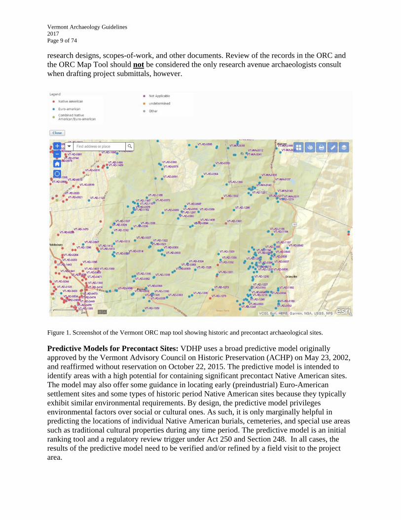
Online Resource Center: The Online Resource Center (ORC) is a critical tool for
archaeologists preparing research designs and conducting background research. The ORC
provides online access to all of VDHP’s documents related to historic preservation activities in
Vermont since data collection began in the 1960s. It enables staff, consultants, researchers,
educators, and the general public to view hundreds of thousands of documents that were
previously only available in hard copy in our Resource Room in Montpelier. Terrestrial and
underwater archaeological information, such as Vermont Archaeological Inventory (or Site)
forms, reports, and other related files, are restricted from public view. (1 VSA Chapter 5, Section
317 (20)).
Eligible archaeology professionals and academic researchers can request access to the restricted
records by visiting
http://accd.vermont.gov/strong_communities/preservation/online_research_center.
Please review the VAI ORC Policy for User Access and complete the VAI ORC Instructions and
Application. If approved, the applicant will be issued a username and password to access the
archaeology records in the ORC. Passwords universally expire on the first day of every new
year. Consultants and researchers must submit a new application annually to regain access to the
ORC.
ORC Map Tool: Beginning in the fall of 2015, the ORC Map Tool was made accessible through
the ORC for those consultants and researchers that have archaeological records access. It is a
GIS-based map portal that dynamically displays location data with retrievable information on
each site. Various base layers can be chosen to underlie the data and exportable maps can be
generated for research and reporting purposes. Used in concert with the scanned records on the
ORC, the ORC Map Tool provides archaeologists unprecedented opportunities to prepare
The VDHP reserves the right to withhold access to the ORC. Likewise, access to the
ORC may be revoked at any time or not renewed if signees are found to be misusing
the ORC or failing to honor their signed agreement.
Vermont Archaeology Guidelines
2017
Page 9 of 74
research designs, scopes-of-work, and other documents. Review of the records in the ORC and
the ORC Map Tool should not be considered the only research avenue archaeologists consult
when drafting project submittals, however.
Figure 1. Screenshot of the Vermont ORC map tool showing historic and precontact archaeological sites.
Predictive Models for Precontact Sites: VDHP uses a broad predictive model originally
approved by the Vermont Advisory Council on Historic Preservation (ACHP) on May 23, 2002,
and reaffirmed without reservation on October 22, 2015. The predictive model is intended to
identify areas with a high potential for containing significant precontact Native American sites.
The model may also offer some guidance in locating early (preindustrial) Euro-American
settlement sites and some types of historic period Native American sites because they typically
exhibit similar environmental requirements. By design, the predictive model privileges
environmental factors over social or cultural ones. As such, it is only marginally helpful in
predicting the locations of individual Native American burials, cemeteries, and special use areas
such as traditional cultural properties during any time period. The predictive model is an initial
ranking tool and a regulatory review trigger under Act 250 and Section 248. In all cases, the
results of the predictive model need to be verified and/or refined by a field visit to the project
area.

Vermont Archaeology Guidelines
2017
Page 10 of 74
For large project areas, and particularly for project areas with discontinuous parcels, more than
one predictive model may need to completed. Consultants should consult with VDHP if they are
unsure how many predictive models may be required for a particular project. If there are
numerous discontinuous project areas over a significant distance, a Phase IA may be more
appropriate.
Vermont Archaeology Guidelines
2017
Page 11 of 74
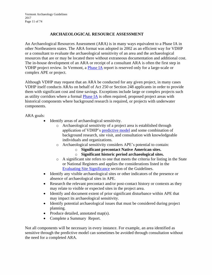
ARCHAEOLOGICAL RESOURCE ASSESSMENT
An Archaeological Resources Assessment (ARA) is in many ways equivalent to a Phase IA in
other Northeastern states. The ARA format was adopted in 2002 as an efficient way for VDHP
or a consultant to evaluate the archaeological sensitivity of an area and the archaeological
resources that are or may be located there without extraneous documentation and additional cost.
The in-house development of an ARA or receipt of a consultant ARA is often the first step in
VDHP project review. In Vermont, a Phase IA report is reserved only for a large-scale or
complex APE or project.
Although VDHP may request that an ARA be conducted for any given project, in many cases
VDHP itself conducts ARAs on behalf of Act 250 or Section 248 applicants in order to provide
them with significant cost and time savings. Exceptions include large or complex projects such
as utility corridors where a formal Phase IA is often required, proposed project areas with
historical components where background research is required, or projects with underwater
components.
ARA goals:
Identify areas of archaeological sensitivity.
o Archaeological sensitivity of a project area is established through
application of VDHP’s predictive model and some combination of
background research, site visit, and consultation with knowledgeable
individuals and organizations.
o Archaeological sensitivity considers APE’s potential to contain:
o Significant precontact Native American sites.
o Significant historic period archaeological sites.
o A significant site refers to one that meets the criteria for listing in the State
or National Registers and applies the considerations listed in the
Evaluating Site Significance section of the Guidelines.
Identify any visible archaeological sites or other indicators of the presence or
absence of archaeological sites in APE.
Research the relevant precontact and/or post-contact history or contexts as they
may relate to visible or expected sites in the project area.
Identify and document extent of prior significant disturbance within APE that
may impact its archaeological sensitivity.
Identify potential archaeological issues that must be considered during project
planning.
Produce detailed, annotated map(s).
Complete a Summary Report.
Not all components will be necessary in every instance. For example, an area identified as
sensitive through the predictive model can sometimes be avoided through consultation without
the need for a completed ARA.
Vermont Archaeology Guidelines
2017
Page 12 of 74
Figure 2. VDHP project review flow chart for archaeological investigations.
Field Inspection or Site Visit
A field inspection or site visit should confirm that some, all, or none of the project area has the
potential to contain a significant site. The site visit should also identify highly disturbed,
developed, exceedingly wet, or steep areas, and/or recommend ways for avoiding sensitive areas.
A site visit begins with a complete walkover of the project area to assess landforms and major or
minor environmental features (for example, level land, relict watercourses, slope, rock outcrops,
springs, soil types, etc.) that may have influenced past land use, and to confirm or refine the
findings of the predictive model. If the project is underwater, an appropriate visual investigation
may also be necessary.
The archaeologist may put in a limited number of soil cores to confirm disturbance or soil
integrity and to determine the presence of buried intact soil layers. No soil coring should be
carried out if it is likely to disturb burial sites. Past disturbance that may have seriously affected
the preservation of archaeological sites must be sufficiently documented to allow for verification
by VDHP. Documentation of disturbance can include photographs, maps, representative core
samples, and/or construction records. Please note that unless the landowner/developer
specifically forbids the disturbance of surface vegetation in an APE, lack of visibility due to
thick vegetation (such as tall grass, weeds, thorns, or other brush or bushes) is not sufficient to
Vermont Archaeology Guidelines
2017
Page 13 of 74
forgo a site visit or make sensitivity determinations. Winter field visits, conversely, may not be
productive (see below and Performing Identification).
If the project’s APE contains a visible archaeological site or historic feature, additional
information should be provided. If it has not previously been documented, obtain a VAI site
number from VDHP and complete a VAI site form at the earliest opportunity. A description of
the site should also be included in the ARA. .
Winter Limitations (ARA, SOW, and all Phases). The typical excavation or “field” season
runs from late spring, following snow melt, ground thaw, and dryer soil conditions, until mid-
November when snow begins to obscure the ground surface and/or the ground freezes. Because
of the variability in weather and temperature in Vermont from year to year, VDHP does not set
fixed starting and ending dates for the field season. Nevertheless, site visits in winter when
topographic features are buried in snow and soil coring is impossible are not usually productive,
and ARAs or SOWs derived from them may be rejected.
Investigations during prolonged cold and wet weather, in particular, are strongly discouraged.
VDHP’s previous experiences with winter excavations have demonstrated that data recovery and
fieldwork practices are substantially diminished relative to excavations conducted in better
conditions. Special provisions for shelter and heat in the area to be investigated are possible in
some instances, but preparation usually needs to be done prior to the ground freezing. Moreover,
excavations using these techniques are usually quite costly and logistically complicated, and so
are generally not recommended. VDHP reserves the right to reject SOW or End-of-Field Letters
that propose or report on excavations in winter conditions without prior consultation with VDHP.
Defining Previous “Significant” Ground Disturbance. Significant ground disturbance of an
area is defined as a place that was once archaeologically sensitive or where a site was previously
identified, but that has been heavily disturbed or destroyed by some action prior to the proposed
project. Past plowing, cultivation, and logging do not necessarily constitute "significant" ground
disturbance because studies have shown that important cultural information can be retrieved
from within or under plowzones and logged surfaces. Deeper deposits such as fire hearths and
refuse pits are often identified in these contexts, for instance. In many cases, filling (on land or
underwater) may also not constitute "significant" ground disturbance because intact, significant
precontact and historic period sites may lie buried beneath the fill layer(s). Generally, significant
ground disturbance results from historic or modern development, or natural erosional actions
including historic flooding (scouring) or landslides.
Map Documentation
Project plan(s), if available, should be used as the base map to document the findings of the
ARA. If not available, the archaeological consultant should use the best, scaled map available in
conjunction with overlying, georeferenced areas or features of note. Specifically, the map(s)
should be keyed and annotated to identify sensitive areas, disturbed areas, newly recorded sites,
previously documented sites (identified by site number), relevant landscape or cultural features,
and/or any other relevant information that can assist the client and reviewers in their respective
planning, design, and review tasks.

Vermont Archaeology Guidelines
2017
Page 14 of 74
Additional documentation may include past site plans, photographs showing previous
construction zones and areas of previous disturbance, and/or an overall project area location
map. A sub-meter Global Positioning System (GPS) unit or other accurate recordation system is
required in order to accurately delimit identified area boundaries in relation to the overall APE.
With the advances in Geographic Information Systems (GIS) and/or Computer Assisted Design
(CAD) software, and its increasing prevalence in project design, VDHP will have no tolerance
for loosely defined or inaccurately drawn boundaries based upon equipment with poor
resolutions or through errors of angle and distance measurements. Although VDHP is aware of
the costs associated with GIS software, GPS units, and other related equipment, its centrality to
location-based endeavors such as archaeology necessitates consultants utilize and require
deliverables generated from these products. Additional GIS deliverables are outlined in the
sections that follow and in appropriate appendices.
Photographic Documentation
Photographic documentation is helpful in an ARA to understand complex features or to
document identified archaeological sites or significant disturbances. The photographs may be
embedded in an associated PDF or word file, but should of a significant resolution and clarity to
clearly discern the subject(s). A photographs should be keyed to a locational map as appropriate.
ARA Report
An ARA results in a Report that outlines findings and recommendations. If the ARA concludes
that the project area has no, or low, potential for containing significant archaeological sites, the
Report may address only the relevant items on this list. The ARA Report should include:
Identify the document as an “Archaeological Resources Assessment Report.”
Project name, town, and county.
Identify specific legal jurisdiction (i.e. Act 250, Section 106, 22 VSA 14, 30 VSA
5, Section 248, or a combination of several).
Project description, including date of plans used in the course of the ARA.
Completed predictive model and a brief summary of rationale.
A description of APE.
Overview map with project area and APE delineated; Annotated map(s).
Brief description of site-visit methods and type of ground cover, vegetation, and
other land use that influenced or affected observations.
Brief description and extent of areas that are significantly disturbed and need no
further consideration.
Detailed information for any visible historic period or precontact period
archaeological sites or features observed within the APE.
Statement and supporting information for why the project area is not likely to
contain significant archaeological sites OR brief description of the confirmed
archaeological sensitivity of the project area, its extent(s) and expected significant
site types.
Vermont Archaeology Guidelines
2017
Page 15 of 74
Summary of background research describing types of significant sites that may
exist in the project area and support for the likelihood, or not, of identifying
significant sites; Research design.
Recommendations, including a description of potential archaeological issues that
need to be considered during project planning (this section may include
conditions for avoiding and preserving the sensitive areas during and after
construction; additional background research; related Phase I archaeological
investigations; erecting fencing during construction; etc.).
Soil core profiles, if useful in documenting conclusions and recommendations.
Photographs, if appropriate, keyed to map.
Redacted Copy of Document (see Redaction below).
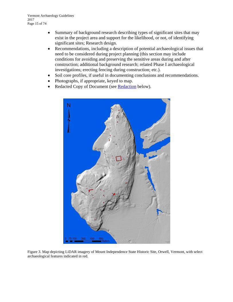
Figure 3. Map depicting LiDAR imagery of Mount Independence State Historic Site, Orwell, Vermont, with select
archaeological features indicated in red.

Vermont Archaeology Guidelines
2017
Page 16 of 74
SCOPE OF WORK
A Scope of Work (SOW) informs the project sponsor about the work to be performed for all
phases, sets forth expectations, provides a schedule, includes cost estimates and budgets for the
task at hand, and provides justification for the work. In some cases, a detailed Phase I SOW may
also serve as an ARA if it is clear that archaeological investigation will be necessary within the
project APE or if a client requests it. In those cases, a predictive model, justification, and other
pertinent documentation must be included in the SOW.
VDHP recommends that the SOW be incorporated into any project contract between the
archaeological consultant and the project sponsor. This will help ensure that all parts of the
archaeological study will be completed and are the joint responsibility, under contract, of the
project sponsor and the consulting archaeologist. Although VDHP does not involve itself in
contractual agreements between the applicant and consultant, it reminds consultants of the
ethical obligation to submit appropriate information about the archaeological sites they have
surveyed or excavated. VDHP subscribes to the Society for American Archaeology’s Principles
of Archaeological Ethics and expects consultants to adhere to them.
Preparing a Scope of Work
The SOW sets forth the project's research design and includes, at a minimum, a detailed
discussion of:
Specific legal jurisdiction (i.e. Act 250, Section 106, 22 VSA 14, 30 VSA 5,
Section 248, or a combination of several).
Client and project sponsor.
Project APE, including number of acres/hectares to be reviewed.
Research design including proposed field methodology.
Potential project impacts if known.
Estimated schedule in calendar days of all study tasks, including background
research, beginning and ending date of field work, analyses and interpretation,
report, public education and outreach activities, and any other major task.
Expected public education and outreach efforts during Phase II or Phase III
excavations or in other special cases (see Public Outreach & Education)
Care and management plan of archaeological collections, data, and records (see
Care and Management of Archaeological Collections).
Names of key personnel responsible for work.
Sources of funding.
Redacted Copy of Document (see Redaction section below).
Budget (not generally provided to VDHP).
Cost estimates and budgets for an archaeological investigation should clearly identify all costs
and special add-on costs.

Vermont Archaeology Guidelines
2017
Page 17 of 74
VDHP Review of Scopes of Work
Agreement documents such as programmatic agreements, memoranda of agreement, land use
permits or certificates of public good often require Scope of Work approval from the VDHP.
Even if it is not required, VDHP strongly recommends that the SOW be submitted for review
and comment prior to a request for final concurrence. VDHP review of a SOW may reduce the
need for additional work, or, alternatively, VDHP may recommend less work. From VDHP’s
point of view, the most important aspect of the SOW is the Research Design. VDHP shall review
SOW for Phase I studies within 30 days of receipt. The SOW can be submitted by the project
sponsor or consulting archaeologist. VDHP reserves the right to reject studies that have been
conducted without Scope of Work approval and/or do not meet State Guidelines.
Phase II and III scopes are viewed as collaborative efforts requiring more time and interaction
among VDHP, archaeological consultant, and client/project sponsor. Phase III archaeological
investigations, in particular, generally require detailed conversations about the levels and kinds
of sampling undertaken within the APE relative to known site densities and limits. VDHP review
of Phase II or III SOWs shall be completed within 30 days following a formal request.
Collections Care and Management Issues in Scopes of Work
The SOW must indicate how and where all field notes, records, artifacts, and other data sets will
be assembled, cared for, and managed during the analysis process and in the future. The Vermont
Archaeology Heritage Center (VAHC) is the state’s curation facility. VDHP encourages
donation of all collections to VAHC.
VAHC currently charges a standard per-box fee of $500 for permanent curation (fee set by
statute). Collections derived from excavations conducted on state-owned land must be curated at
VAHC, and monies should be budgeted for their care in any SOW. VAHC cannot accept any
collections excavated from private land without a signed Deed of Gift form from the landowner
(see Care and Management of Archaeological Collections). It is the right of the landowner to
choose to retain all, part, or none of the collection. Similarly, however, VDHP may also choose
not to take partial collections if the value of retention of specific data classes to the exclusion of
the whole assemblage is not deemed to be scientifically defensible or beneficial. In the SOW,
consulting archaeologists must inform clients/project sponsors about the various issues relating
to collections care and management.
Responsibilities for collections gathered during the investigation will differ depending on
whether the land is privately or publicly owned, whether the project is privately or publicly
funded, if there are relevant statutory jurisdictions or permits, and other factors such as the
existence of PAs or Historic Property Management Plans. Phase II and III SOWs must describe
in detail how all classes of data will be analyzed, cared for, and managed after recovery. The
amount or kinds of analyses VDHP recommends as appropriate for mitigation depends on
whether artifacts derived from Phases II and III excavations can be retained for long-term
curation and study.
Vermont Archaeology Guidelines
2017
Page 18 of 74
Other Considerations
Permits for Archaeological Investigations on State Lands, State Archaeological
Landmarks, Under State Waters, or on Federal Lands. The Vermont Historic Preservation
Act (22 VSA 14, sections 764 and 782) directs the SHPO, with the advice of the State
Archaeologist, to issue permits for exploration and field investigations to be undertaken on state
lands, within the boundaries of a designated state archaeological landmark, or under state waters.
State lands include all lands owned by any state agency, including but not limited to VDHP,
Agency of Natural Resources, Agency of Agriculture, and Agency of Transportation. Such lands
may include state-owned historic sites, state parks, wildlife management areas, state forests,
lands purchased for rights-of-way, or lands purchased to allow for projects such as highway
improvements or new construction.
Permits are required for any field investigation that has the potential of disturbing, destroying, or
otherwise altering a sensitive site, cultural materials, or other data that may be contained within
the site or sensitive area. This includes Phase I archaeological site identification surveys,
including surface surveys. Permits are not required for desk reviews, walkovers without artifact
recovery, photographic documentation, and other non-disturbing research and activities.
Archaeological consultants generally apply for permits on behalf of the applicable state agency
or another client. All permit requests should be made to VDHP.
Consultants retained by a State agency or who are conducting ongoing work on state lands may
request and VDHP may issue an annual permit. In that case, the consultant may work under that
single permit to the end of the calendar year or for a year from the date of application at VDHP’s
discretion. Consultants must have a demonstrated need for an annual permit. Consultants doing
single projects on state land or under state waters will be issued a one-time permit.
Although special conditions will vary for each permit issued by VDHP, consultants are reminded
that any outreach and/or press interactions related to work on state land or under state waters
must acknowledge VDHP and any other State agency for whom the work is being conducted.
Logos for printed material can be requested from VDHP.
In accordance with the federal Archeological Resources Protection Act of 1979 (ARPA), it is
illegal to excavate or remove archaeological resources from any federal land without a permit
from the federal land manager. Examples of federal land managers in Vermont include the U.S.
Forest Service and the U.S. Fish and Wildlife Service, among others. Individual land managers
should be contacted for ARPA permit application information.
Redaction (ARA, SOW, and all Phases). Many state and federal regulating authorities have
moved to or are currently in the process of moving to online portals for permit applications and
project reviews. Archaeological consultant submissions and VDHP comments are often part of
those online application packets; easily accessible by any member of the public. Not only does
this violate Vermont State statute, but it potentially endangers the archaeological sites the statute,
and our work more broadly, seeks to preserve and protect. As such, VDHP is requiring that all
consultants produce two digital copies of any document submitted to VDHP if those documents
contain any archaeological site location information. One copy should be unredacted, which will
Vermont Archaeology Guidelines
2017
Page 19 of 74
be submitted to the applicant and archived on VDHP ORC. The phrase “Not for Public
Distribution” should be prominently printed on the front cover. The other copy to be submitted to
the regulating authority should be redacted so that location information is deleted or covered
over. For the purposes of redaction, archaeological site location information includes:
Maps that include detailed excavation or surface collection maps with artifact locations.
Maps that depict archaeological site locations with enough specificity that they could be
relocated by the public.
Coordinates of archaeological sites.
At this point, VDHP is not expecting consultants to redact textual descriptions of site locations,
unless there is a clear need (i.e. detailed descriptions of burial locations). Likewise, maps of
archaeologically sensitive areas do not need to be redacted. Consultants should, however, feel
free to redact additional text, maps or images if they feel that the information presented would
potentially compromise an archaeological site or sites if reviewed by an unscrupulous member of
the public.
Vermont Archaeology Guidelines
2017
Page 20 of 74
PHASE IA INVESTIGATION: RECONNAISSANCE
In Vermont, Phase IA reconnaissance investigations are intended only for special types of
projects and circumstances. Examples include but are not limited to:
Projects with multiple alignments that require Environmental Assessments or
Environmental Impact Statements.
Projects with single, wide planning corridors.
Master plans.
Management plans.
Overviews of large landholdings for which no specific developments are
immediately proposed.
New pipelines and transmission lines.
Hydroelectric dam relicensing.
Projects on complex contexts or special circumstances, such as those proposed for
deep floodplains or in urban settings where pavement or fill deposits cover
potentially sensitive areas.
The Phase IA investigation generally involves a great deal more background research and
intensive field assessment relative to a typical ARA, including more initial consultation with the
community, knowledgeable local informants, Native Americans, and other interested parties.
Goals of the Phase IA investigation include:
Conduct intensive background research.
Identify and rank areas of archaeological sensitivity.
Identify visible archaeological sites or other indicators of the presence or absence
of sites.
Identify and document the extent of prior significant ground disturbance.
Identify potential archaeological issues that must be considered during project
planning.
Establish, if possible, whether or not any visible or previously documented sites
have a high likelihood of being eligible for the State and/or National Registers of
Historic Places.
Developing Alternative Predictive Models
Depending on the project size, scope, and research design, an archaeological site predictive
model specific to the scale and scope of the project and APE may need to be developed during
the Phase IA investigation. The model is tested during the Phase I field investigation. In some
cases, such as when the model is developed as part of a Phase IA management plan, it serves as
the framework for planning future developments to minimize disturbing archaeologically
sensitive lands. Model development is based on intensive background research accompanied by a
detailed understanding of the project’s varied landforms, environmental characteristics, statistical
reasoning, and/or relevant precontact historic contexts. New predictive models used in state and
federal reviews must be approved by the Vermont ACHP in accordance with the Vermont
Historic Preservation Act Rule 2 (see Relevant Statutory Authority). Excepting the special case
Vermont Archaeology Guidelines
2017
Page 21 of 74
outlined above, the Phase IA investigation typically results in a “stand alone” report that meets
the requirements of a Phase I investigation report.
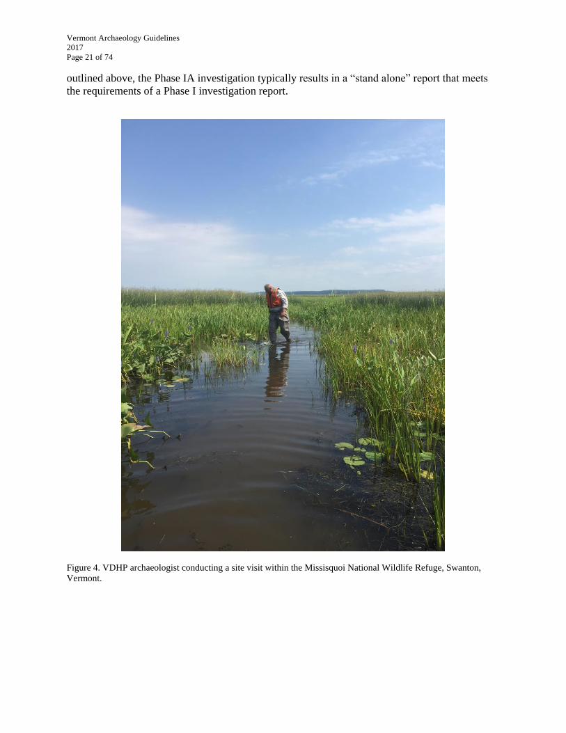
Figure 4. VDHP archaeologist conducting a site visit within the Missisquoi National Wildlife Refuge, Swanton,
Vermont.

Vermont Archaeology Guidelines
2017
Page 22 of 74
PHASE I INVESTIGATION: IDENTIFICATION SURVEY
The National Historic Preservation Act (NHPA) refers to the “identification of historic
properties” in initial archaeological investigations. The term “historic property” is defined in the
NHPA as, “any prehistoric or historic district, site, building, structure, or object included in, or
eligible for inclusion on, the National Register; including artifacts, records, and material remains
relating to the district, site, building, structure, or object.” Thus, the goal of identification studies
under the federal process is to locate National Register-eligible historic properties.
Practical considerations generally necessitate that archaeological investigations be divided into
separate, sequential phases. The intent of the phased approach is to provide a framework for
estimating the cost of finding a site and then, as a second step, for gathering additional detailed
information for evaluating a site’s significance if it cannot be avoided. If a site can be determined
significant at the completion of Phase I, it should be. If identifying and evaluating a site’s
significance is practical as a single step for a particular situation, then that should occur. The
Guidelines emphasize VDHP’s goal of determining site significance as soon as is possible, based
upon available evidence.
Phase I Field Investigations
The following guidelines outline standard field practices for Phase I archaeological
investigations in Vermont. VDHP seeks common sense approaches to archaeological
investigations. Alternative approaches should be determined in consultation with VDHP and the
project sponsor prior to the development of the Research Design or during the Scope of Work
review.
Surface Survey
Surface survey on recently plowed agricultural fields may be an appropriate method for
efficiently identifying the presence of an archaeological site. Walking linear transects of 1 to 2
meters (or arm’s length) apart is recommended to find evidence of small sites. To allow for
artifact recognition, the plowed surface must have recently received a minimum of 1/2” of rain to
wash dust and soil off of artifacts.
Plowing should only be used as an archaeological field method if a plowzone already exists to
modern depths. If plowing the ground surface is being considered as a field investigation method
and the surface is not currently an open, plowed field, it is necessary to first verify the existence
of a plowzone through preliminary sub-surface testing or coring. Plowing a field that has never
been plowed, or plowed generations ago to a shallow depth, will degrade the integrity of a site.
Similarly, harrowing a recently plowed field is appropriate; harrowing an old hay field or fallow
field may not be appropriate. These conditions need to be determined during the site visit.
In floodplains, a stratigraphic assessment is necessary to confirm the suitability of surface
collection as an appropriate method of site discovery and evaluation. In such cases, plowing may
not reach the depths of any or all precontact deposits. At a minimum, subsurface test pits are

Vermont Archaeology Guidelines
2017
Page 23 of 74
necessary to verify the depth of the surface plowzone, determine the existence of buried
plowzones or cultural levels, and to understand the overall stratigraphic context of the area. In
complex or especially deep floodplain settings, deep backhoe testing may be necessary to obtain
this information, depending upon the site and/or project impact.
The locations of particular surface artifacts should be recorded within the APE and recovered for
analysis. If the number of artifacts is voluminous, the consultant should contact VDHP about
potential alternative information and artifact collection strategies. In general, however, the spatial
information of surface artifacts is a very important component of the overall site context and
VDHP requires this information.
Recording measurements (all Phases). In general, all measurements should be recorded in the
metric system. In cases of historic sites, including shipwrecks, English measurements can be
reported with metrics in parenthesis. VDHP expects consultants and archaeologists to record
measurements accurately and with significant precision to ensure the demarcation of accurate
buffers, project boundaries, site densities and sampling units, etc. With the tools now available to
consultants, there is no excuse for generalized or loosely defined demarcations of space.
Ground Sensing Methods for Historic and Precontact Period Sites. Historic period
archaeological sites and some precontact sites may be discovered using modern technologies
such as metal detectors, ground penetrating radar (GPR), or electro-magnetic induction, among
other techniques. These methods may be beneficial to guide the locations and configurations of
subsurface testing. Although VDHP encourages the use of these non-destructive techniques in a
general way, it also understands that the complicated, formally glaciated geological environment
in Vermont, combined with a history of fluctuating Holocene forest cover, makes these
techniques more difficult to apply and interpret uniformly. Consultants and others are
encouraged to consult with VDHP prior to using these techniques in field studies. Typically,
these technologies are applied during Phase I investigations but may be used in all assessment
steps, including as a step in the ARA.
Treating Isolated, or Limited, Surface Artifacts. Precontact and contact period sites identified
through systematic surface survey in cultivated fields require the excavation of a minimum of
four shovel test pits in the area of each surface artifact. If more than a single artifact is
subsequently recovered, it can no longer be considered isolated, and appropriate Phase I site
identification procedures should follow. The number of additional test pits should be based on
the size of the surface concentration(s). The purpose of these additional test pits is to evaluate
artifact densities, document soil profiles within these concentrations and provide preliminary
information on the potential for sub-plowzone site components or deposits. This additional
information will improve planning for any Phase II field investigation that may be necessary if a
recommendation of site significance cannot be determined at the conclusion of the Phase I
survey. Some types of potentially significant historic period sites, for example, those pertaining
to military encampments, French settlements, or early Euro-American settlement, may also need
this type of treatment.
Vermont Archaeology Guidelines
2017
Page 24 of 74
Sub-Surface Testing
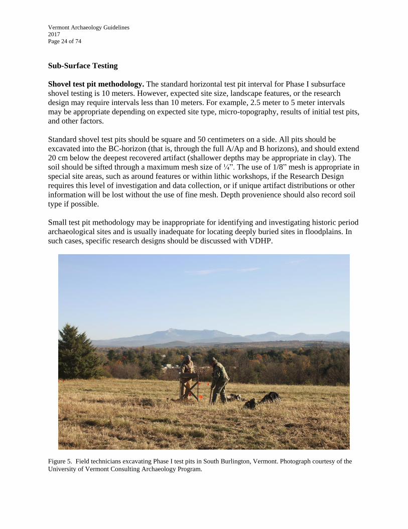
Shovel test pit methodology. The standard horizontal test pit interval for Phase I subsurface
shovel testing is 10 meters. However, expected site size, landscape features, or the research
design may require intervals less than 10 meters. For example, 2.5 meter to 5 meter intervals
may be appropriate depending on expected site type, micro-topography, results of initial test pits,
and other factors.
Standard shovel test pits should be square and 50 centimeters on a side. All pits should be
excavated into the BC-horizon (that is, through the full A/Ap and B horizons), and should extend
20 cm below the deepest recovered artifact (shallower depths may be appropriate in clay). The
soil should be sifted through a maximum mesh size of ¼”. The use of 1/8” mesh is appropriate in
special site areas, such as around features or within lithic workshops, if the Research Design
requires this level of investigation and data collection, or if unique artifact distributions or other
information will be lost without the use of fine mesh. Depth provenience should also record soil
type if possible.
Small test pit methodology may be inappropriate for identifying and investigating historic period
archaeological sites and is usually inadequate for locating deeply buried sites in floodplains. In
such cases, specific research designs should be discussed with VDHP.
Figure 5. Field technicians excavating Phase I test pits in South Burlington, Vermont. Photograph courtesy of the
University of Vermont Consulting Archaeology Program.
Vermont Archaeology Guidelines
2017
Page 25 of 74
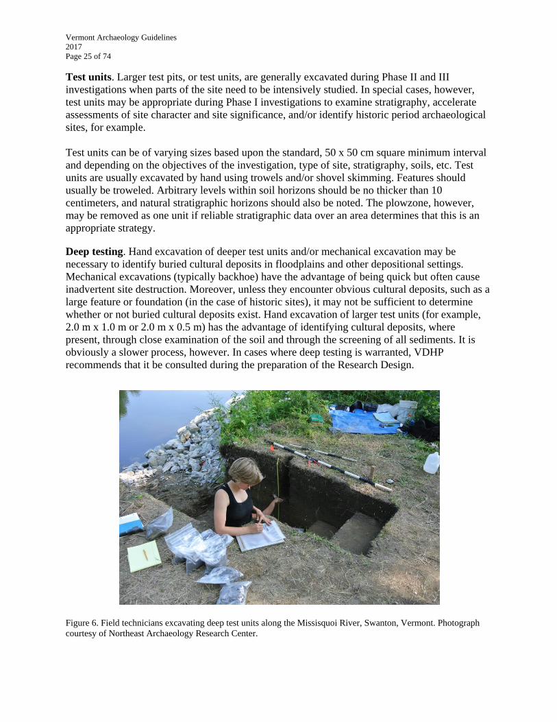
Test units. Larger test pits, or test units, are generally excavated during Phase II and III
investigations when parts of the site need to be intensively studied. In special cases, however,
test units may be appropriate during Phase I investigations to examine stratigraphy, accelerate
assessments of site character and site significance, and/or identify historic period archaeological
sites, for example.
Test units can be of varying sizes based upon the standard, 50 x 50 cm square minimum interval
and depending on the objectives of the investigation, type of site, stratigraphy, soils, etc. Test
units are usually excavated by hand using trowels and/or shovel skimming. Features should
usually be troweled. Arbitrary levels within soil horizons should be no thicker than 10
centimeters, and natural stratigraphic horizons should also be noted. The plowzone, however,
may be removed as one unit if reliable stratigraphic data over an area determines that this is an
appropriate strategy.
Deep testing. Hand excavation of deeper test units and/or mechanical excavation may be
necessary to identify buried cultural deposits in floodplains and other depositional settings.
Mechanical excavations (typically backhoe) have the advantage of being quick but often cause
inadvertent site destruction. Moreover, unless they encounter obvious cultural deposits, such as a
large feature or foundation (in the case of historic sites), it may not be sufficient to determine
whether or not buried cultural deposits exist. Hand excavation of larger test units (for example,
2.0 m x 1.0 m or 2.0 m x 0.5 m) has the advantage of identifying cultural deposits, where
present, through close examination of the soil and through the screening of all sediments. It is
obviously a slower process, however. In cases where deep testing is warranted, VDHP
recommends that it be consulted during the preparation of the Research Design.
Figure 6. Field technicians excavating deep test units along the Missisquoi River, Swanton, Vermont. Photograph
courtesy of Northeast Archaeology Research Center.

Vermont Archaeology Guidelines
2017
Page 26 of 74
Treating Isolated, or Limited, Sub-Surface Artifacts. Positive test pits containing precontact
cultural materials are considered “isolated” if they are separated by at least 24 meters and if they
only contain a single artifact. In these instances, it is possible to eliminate the need for any
subsequent testing by excavating twelve additional test pits at reduced intervals around the
original test pit. No further testing is needed provided all additional test pits are negative. If any
of the additional test pits are found to contain additional artifacts or features, more
comprehensive testing will be needed to evaluate the site and assess potential project impacts.
Some types of potentially significant historic period sites, for example, those pertaining to
military encampments, French settlements, or early Euro-American settlements, may also need
this type of treatment.
Precontact Feature Excavation Protocols
In Vermont, precontact features are one of an archaeological site’s most important data sources,
and often a critical component in establishing a site’s significance. Features may contain
subsistence or medicinal remains, evidence of cooking, processing, or discard practices,
preferential preservation of organic artifacts due to charring and/or calcification, and material for
radiocarbon dating, paleobotanical/paleofaunal analyses, and environmental reconstructions,
among other information.
Special care needs to be taken with definitive or suspected precontact features. If reasonable, the
soil from precontact features encountered during Phase I surveys should be retained and
processed through flotation in the laboratory. When a Phase I survey is proposed in an area
where precontact features are strongly suspected to be present or within a known archaeological
site where features were previously identified, feature soil retention and processing should be
budgeted for in SOW.
If a suspected precontact feature is identified during a Phase I survey and the soil cannot be
retained and processed because it cannot be accommodated with the existing budget, a budget
alteration should be requested from the applicant or the feature should be covered and left in
place for a subsequent Phase II investigation.
Potential cultural features may be explored through excavation without soil retention for the
purposes of determining its legitimacy as a precontact deposit, but in those cases as much of the
feature as possible should be left intact. It should not be standard practice during any phase of
investigation to completely excavate features without soil retention, processing, and subsequent
analysis.
Discovery and Treatment of Human Remains (All Phases)
It is against the law to excavate an unmarked burial in Vermont, except under the provisions
outlined in Title 18, Chapter 107 of the Vermont Statutes, and specifically 18 VSA §5212b. All
consultants should read and be familiar with the statute. In general, however, it necessitates that
all excavation should cease upon the identification of definitive human remains and the police
should be informed. They will contact the medical examiner, who will determine whether or not
Vermont Archaeology Guidelines
2017
Page 27 of 74
the remains represent the result of criminal activity. If the medical examiner determines that the
remains are ancient or historic, the state archaeologist will be contacted and begin to consult on
the process. If the burial is in imminent danger of disturbance by natural or human processes,
respectful removal may be conducted in consultation with VDHP and any affiliated tribe(s), as
applicable.
Historic Site Discovery and Investigation
If a project area or portion thereof contains or is likely to contain an historic-era site, different
excavation methodologies may need to be employed. These methodologies will often be guided
by the presumed site thought to be in the area (i.e. barn, residence, fort, etc.), and the accuracy
and detail of the maps and other historic resources that describe it. VDHP is open to reasonable
methodologies in the case of historic period sites, and will review them as part of the ARA or
SOW. Moreover, some sites may require non-invasive documentation such as photography and
background research if they are in danger of destruction, but may not need intrusive excavations.
Identifying important research questions and necessary data sets for Historic-era Sites. The
consulting archaeologist must first identify specific, important research questions that can be
addressed at the site through archaeology that are not likely to be answered by the extant historic
record (see Evaluating Site Significance). Second, it is necessary to identify specific data sets
that must be present and recoverable from the site in order to answer the research questions.
Quality of site evidence. Regulatory archaeology requires that public and private funds are spent
with the reasonable chance of discovering and researching sites that are important to the state
and to individual communities. Accordingly, the quality of the evidence about a site’s existence
in a particular location is an important consideration in determining whether or not to proceed
with assessment of an historic period site.
Some examples of strong evidence for the existence of an historic site in a given location
include:
A recorded VAI site.
Specific documentary reference to a site in that location from historic research.
Specific reference to a site in that location from knowledgeable local individuals.
Visible ruins and features on the ground surface.
Geographic or historic context that suggests the existence of a site or particular
category of site (for example: the presence of an early road --often associated with
early homesteads; known French “seigniories” along Lake Champlain; etc.)
Probable structure identified through LiDAR or other imaging techniques.
The standing structure itself is listed on or eligible for the State and/or National
Registers and is associated with a priority research topic: it may have
archaeological components that contribute significant archaeological information.
Summary of Information Needed by VDHP to Determine if Historic Site Assessment
Process Should Continue. As early as possible in the historic period archaeological assessment
process (ARA or Phase I), the consulting archaeologist should determine and demonstrate to
VDHP that:
Vermont Archaeology Guidelines
2017
Page 28 of 74
The site has the potential of addressing one or more of the priority topics listed in
the Evaluating Site Significance section of this document.
There is strong evidence for the site’s existence in that location.
The site has the potential to answer – through excavation – specific, important
research questions.
The research questions being asked are of interest to a broad audience.
The site is likely to contain specific and recoverable categories of data that answer
the research questions.
The site exhibits integrity or the likelihood of integrity.
Site Numbers and Acquiring Site Numbers for Newly Identified Archaeological Sites
Site numbers always begin with the “VT” state abbreviation, followed by the two-letter
abbreviation of the county where the site was found, followed by a four-digit number that
denotes the current site count for that county. As a result of background research, the consultant
or researcher should be aware of any previously identified archaeological site(s) within or
adjacent to the APE on which they are working. If a site needs to be revisited, the Vermont
Archaeological Inventory form should be updated and submitted to the VDHP following the
conclusion of the field work (see Vermont Archaeological Inventory Form). If there are
questions about the boundaries of a particular site, and whether or not it corresponds to the
current project), the consultant should contact VDHP to discuss it.
If a new site is discovered during field investigations, the consultant should request a new site
number from the VAI tab in the ORC. To do this, click on the VAI resources tab and choose the
VAI Site Number Request button. Complete the required fields, including Vermont State Plane
(meter) coordinates of the approximate center of the site area as known, and then submit the
request. VDHP will review the request and send an auto- response if the request is approved, or
follow up with additional guidance if it is not.
Data Generation and Analysis Guidance
The project sponsor is responsible for ensuring that the data analyses are completed and reported
once the artifacts, other cultural materials, and other types of data are removed from the ground
or recorded, regardless of whether or not the project is pursued. The consulting archaeologist is
responsible for conducting appropriate analyses and interpreting the data that tell the story of the
site.
The anticipated data analyses described in the Research Design are the basic analytical tasks that
will be conducted subsequent to the field investigation. The tasks set forth in the Research
Design are obviously based on the types of sites that are expected to be discovered. However,
once a site is identified, there may be a need to change the analytical techniques relative to the
analyses proposed in the research design. If, for example, a Late Archaic site was expected, no
provision will have been made for analyzing and reconstructing pottery fragments. The
archaeological consultant should immediately inform the client if unexpected types and/or the
volume of data categories discovered require additional or markedly different analyses that will
generate additional costs and/or require additional time. VDHP should also be consulted as well
Vermont Archaeology Guidelines
2017
Page 29 of 74
to determine whether or not additional or significantly different methodologies or analyses are
warranted.
At the Phase I level, VDHP is primarily concerned with the documentation of the spatial
arrangement, density and depth of recovered artifacts or features, and the consultant’s
interpretations of these spatial arrangements. It may also be appropriate to discuss how the
sampling methodology contributed to or biased particular findings or the lack thereof.
Reporting Identification Results
Phase I “End-of-Field” Letter. The End-of-Field (EOF) Letter summarizes the results of the
investigation, provides interpretations of the findings, describes anticipated project impacts to
sites and sensitive areas, and offers recommendations for site treatment, additional investigations
or recommendations of no effect, among various other possibilities. In many cases,
determinations of project effect are made by VDHP or a Federal or State agency based on the
EOF Letter. As such, it must clearly articulate the consultant’s findings and recommendations
with appropriate evidence to bolster those findings and recommendations.
Any information or inferences about the site’s potential or apparent significance within the APE
should be presented in the Phase I EOF Letter using the considerations described in the
Evaluating Site Significance section of this document. Specific recommendations for site
avoidance, additional research, additional field investigation, construction redesign, and so forth
are also discussed in to the EOF Letter, as applicable.
EOF Letters used as a basis for final project reviews and decision-making should be more
detailed and comprehensive than those intended as status reports. If no site is found, the EOF
Letter may serve as the final concluding document regarding the archaeological components of a
project (see the checklist below). If the Phase I Site Identification survey documents the presence
of an archaeological site, but the consultant makes a recommendation that the site is not
significant within the APE and the VDHP concurs, an EOF Report may be submitted to VDHP,
which will serve as the final concluding document. If the consultant can complete an EOF Report
within 14 business following the conclusion of the fieldwork, it can then serve as both the
management summary document and the site summary document. Otherwise, a short EOF Letter
sufficient to make determinations of effect should be submitted to VDHP and a more robust EOF
Report should follow afterward.
If a site is identified but is ultimately avoided, protected or otherwise not disturbed after a Phase
I Site Identification survey but before its significance can be determined, a regular final report
should be submitted to VDHP. Finally, if the consultant, applicant, and VDHP agree that the
investigation of a site or sites should advance to the Phase II level, and the consultant is to be
retained for Phase II work, the consultant may submit an EOF status letter outlining that
conclusion and then combine the Phase I and Phase II reports into a single document as a cost-
saving measure.
The Phase I EOF Letter should include the following information, as appropriate:
Vermont Archaeology Guidelines
2017
Page 30 of 74
Identify specific legal jurisdiction (i.e. Act 250, Section 106, 22 VSA 14, 30 VSA
5, Section 248, or a combination of several).
Client and project sponsor.
Dates of fieldwork.
Summary of fieldwork results.
Detailed description of proposed project and impacts to site.
Detailed description of APE, with map.
Annotated, dated site plan and excavation maps; other applicable maps as needed
to clarify findings and recommendations.
o Mapping should note areas tested, archaeologically sensitive areas,
specific locations of test pits or sampling units, and sensitive areas to be
avoided (see shapefile requirements).
o Surface finds and positive test pits should be indicated on maps, as
appropriate.
If a site is found, include the VAI site number on all relevant maps.
Any information or inferences about the site’s potential or apparent significance
using the information described in Evaluating Site Significance.
Description of the anticipated analyses and report writing schedule.
Specific recommendations for avoidance or other treatment, additional research,
additional field investigation, construction redesign, and so forth. If
recommendations cannot be made at this stage, the letter must indicate this.
o If applicable, describe any proposed special project designs and pre-
construction requirements recommended to avoid and protect the site(s),
such as fencing the site off prior to land clearing, restrictions on perc
testing, matting of areas, etc..
Completed Vermont Archaeological Inventory form if a site is found.
Select test pit profiles.
Applicable shapefiles if no archaeological sites were discovered during the
investigation (see Additional Documentation).
Select photographs (see Additional Documentation).
Redacted Copy of Document (see Redaction section).
The EOF Letter should be submitted to the project sponsor and VDHP within 14 business days
of the completion of the field work.
EOF Report
As noted above, Phase I investigations sometimes result in the discovery of a site that the
consultant determines not to be significant within the APE. If VDHP concurs with the
consultant’s findings, the EOF Report format may usually be submitted (potentially in addition
to an abbreviated EOF Letter). The EOF Report is due to VDHP and project sponsor within 60
days of the completion of the field work.
The EOF Report format is usually not appropriate for large, complex projects even if no sites are
found.
Vermont Archaeology Guidelines
2017
Page 31 of 74
Instead of repeating some of the same elements as found in the ARA or SOW, this and other
relevant, existing documents may be referenced in the text or attached as Appendices, as
appropriate. The Short Report should include:
Report cover page that includes:
o Report Title
o Town/ County
o Name of project
o Name of consulting archaeology organization
o Project sponsor
o Date of report
Abstract (see Phase I report writing requirements).
Number of acres/hectares in the area of potential effects.
Number of acres/hectares in the study area.
Detailed description of the proposed project and APE.
All statutory jurisdictions within which the project development falls.
Dates of the field work.
Brief description of the kinds of significant sites that were expected to exist in the
study area.
Brief environmental overview.
Predictive model checklist or narrative summary with scoring.
Summary of the results of the field work.
Description of methodology employed:
o background research
o surface collection
o subsurface shovel testing (including # and size of units)
If no site was found, explain this result using the Phase I Research Design
expectations and predictive model as basis for discussion.
If a site was found and recommended to be not significant, explain this conclusion
and the reasons behind it.
Dated and properly annotated site plans, sketches, and any other applicable maps
that help clarify findings and recommendations.
o The following areas must be mapped, as appropriate:
APE
Archaeologically sensitive areas
specific locations of test pits or other sampling units
Positive test pits and surface find locations
sensitive areas to be avoided
Site limits, as appropriate.
Applicable shapefiles (see Additional Documentation).
Photographs (see Additional Documentation).
Redacted Copy of Document (see Redaction section).
Appendices:
o Copies of select test pit profiles, and artifact inventory, if applicable.
Vermont Archaeology Guidelines
2017
Page 32 of 74
o MOA for project, if applicable
o Other relevant documents
o Completed Vermont Archaeological Inventory form.
Vermont Archaeological Inventory (VAI) Form
The Vermont Archaeological Inventory (VAI) form is a short, fillable form submitted by
consultants from which VDHP populates important information about sites into a centralized
database. The regular format of the data fields enables VDHP, consultants, researchers to view
essential information about sites quickly and to compare sites in statistically relevant ways, now
and in the future. This information must be entered and accessed through the Online Resource
Center portal. Once a site is entered into the online portal and approved by VDHP, a marker will
be generated on the Vermont ORC Map Tool (see the Tools for Preparing Research Designs
section of this document for more information). A VAI form must be completed for any
previously unrecorded site, regardless of significance. Sites that have been or will be completely
destroyed still need a VAI form as a means to account for these sites in the future.
Electronic VAI forms should be submitted when additional information is obtained during the
ARA, Phase I, II or III investigations. Revised VAI forms with updated information must be
submitted at the completion of Phase II and III studies, as appropriate. At this time, VAI sites
cannot be edited by users. Consultants should resubmit a site form with the updated information
and it will be rectified with earlier versions of the form by VDHP administrators.
Phase I Investigation Report
Completion of the EOF Letter does not conclude the archaeological investigation if a potentially
significant site is identified, even if archaeological investigations do not proceed beyond the
Phase I level. A final study report must be completed. Reports are a mandatory, concluding step
of an archaeological investigation unless otherwise exempted (see above). Report writing must
be integrated into the SOW and made part of contractual obligations for any archaeological
investigation. Basic requirements for documenting Phase I investigations follow the Secretary of
the Interior’s Standards and Guidelines for Identification.
An outline and schedule for report writing must be presented in the SOW and should be adhered
to unless there are justifiable reasons why that schedule cannot be met. In general, VDHP
expects that the Phase I project report will be completed within one calendar year of the field
work. Any changes in anticipated schedule should be submitted to the project sponsor and
VDHP at least 30 days before the report is due.
To the extent possible, tables, figures, maps (at all scales), photographs, and any other illustrative
material necessary should appear in the report alongside the explanatory text. Exceptions to this
are:
Oversized maps or other materials
Illustrative materials that are supplementary to the text and the primary
illustrations, or that employ audio-visual, geospatial, or other digital formats.
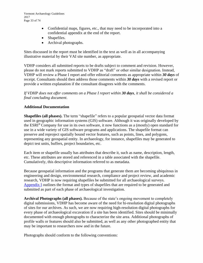
Vermont Archaeology Guidelines
2017
Page 33 of 74
Confidential maps, figures, etc., that may need to be incorporated into a
confidential appendix at the end of the report.
Shapefiles.
Archival photographs.
Sites discussed in the report must be identified in the text as well as in all accompanying
illustrative material by their VAI site number, as appropriate.
VDHP considers all submitted reports to be drafts subject to comment and revision. However,
please do not mark reports submitted to VDHP as “draft” or other similar designation. Instead,
VDHP will review a Phase I report and offer editorial comments as appropriate within 30 days of
receipt. Consultants should then address those comments within 30 days with a revised report or
provide a written explanation if the consultant disagrees with the comments.
If VDHP does not offer comments on a Phase I report within 30 days, it shall be considered a
final concluding document.
Additional Documentation
Shapefiles (all phases). The term “shapefile” refers to a popular geospatial vector data format
used in geographic information systems (GIS) software. Although it was originally developed by
the ESRI® Company for use in its own software, it now functions as a (mostly) open standard for
use in a wide variety of GIS software programs and applications. The shapefile format can
preserve and reproject spatially bound vector features, such as points, lines, and polygons,
representing any geospatial entity. In archaeology, for instance, shapefiles may be generated to
depict test units, buffers, project boundaries, etc.
Each item or shapefile usually has attributes that describe it, such as name, description, length,
etc. These attributes are stored and referenced in a table associated with the shapefile.
Cumulatively, this descriptive information referred to as metadata.
Because geospatial information and the programs that generate them are becoming ubiquitous in
engineering and design, environmental research, compliance and project review, and academic
research, VDHP is now requiring shapefiles be submitted for all archaeological surveys.
Appendix I outlines the format and types of shapefiles that are required to be generated and
submitted as part of each phase of archaeological investigation.
Archival Photographs (all phases). Because of the state’s ongoing movement to completely
digital submissions, VDHP has become aware of the need for hi-resolution digital photographs
of sites for our archives. As such, we are now requiring high-resolution digital photographs for
every phase of archaeological excavation if a site has been identified. Sites should be minimally
documented with enough photographs to characterize the site area. Additional photographs of
profile walls or features should also be submitted, as well as any other photographed entity that
may be important to researchers now and in the future.
Photographs should conform to the following conventions:
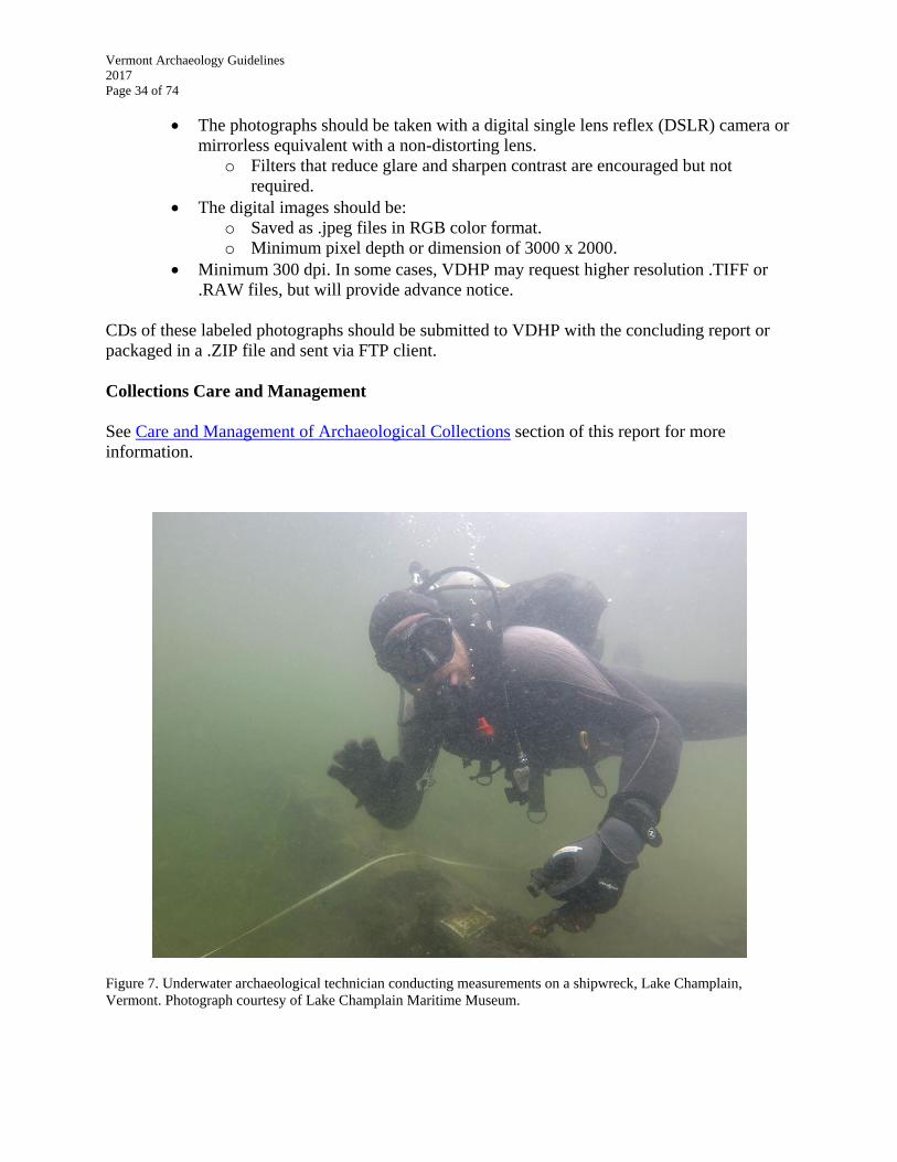
Vermont Archaeology Guidelines
2017
Page 34 of 74
The photographs should be taken with a digital single lens reflex (DSLR) camera or
mirrorless equivalent with a non-distorting lens.
o Filters that reduce glare and sharpen contrast are encouraged but not
required.
The digital images should be:
o Saved as .jpeg files in RGB color format.
o Minimum pixel depth or dimension of 3000 x 2000.
Minimum 300 dpi. In some cases, VDHP may request higher resolution .TIFF or
.RAW files, but will provide advance notice.
CDs of these labeled photographs should be submitted to VDHP with the concluding report or
packaged in a .ZIP file and sent via FTP client.
Collections Care and Management
See Care and Management of Archaeological Collections section of this report for more
information.
Figure 7. Underwater archaeological technician conducting measurements on a shipwreck, Lake Champlain,
Vermont. Photograph courtesy of Lake Champlain Maritime Museum.

Vermont Archaeology Guidelines
2017
Page 35 of 74
PHASE II INVESTIGATION: EVALUATION STUDY
Phase II investigations are often necessary to gather additional information about a site’s
characteristics, its significance, the site’s boundaries within the APE, and/or the project’s
potential impacts to the site.
The goals of any Phase II Investigation are to:
Conclusively establish whether or not a site meets the criteria for inclusion in the
State and/or National Registers..
Define the boundaries of the archaeological site within the APE so as to make
appropriate avoidance or mitigation decisions.
Meet the objectives of the Research Design.
Research Design Requirements for Phase II Investigations
The Phase II Research Design should:
Meet the Research Design Standards (see the Research Design section of this
report); and
Include the following:
o A detailed discussion of project objectives, research questions and topics
that remain unanswered after the Phase I excavations, and expected results.
o Provide a detailed discussion of the proposed background research needed
to obtain comparative information on potentially relevant site types, data
categories, and necessary local and regional contexts.
o Describe and justify the sampling strategy, field methods, and intensity of
investigation at each site to be investigated based on the site type, expected
data categories, project and research objectives, and the determinations of
site boundaries and significance.
o Discuss the care and management for the recovered archaeological
collections, including field notes, other records, artifacts, and other data
categories to be recovered. Discuss how large volumes of redundant data,
such as construction materials at a historic site, will be treated.
Field Investigations and Data Analyses
Proposed field methods should be adequate to efficiently evaluate the site’s significance and to
define the site’s boundaries within the project’s APE. These may include, but are not limited to,
additional shovel test pits at reduced intervals, block excavations around features and artifact
concentrations, deep testing, remote sensing studies, among others. The research design should
also address how the recovered data will be analyzed and interpreted, and which techniques and
theoretical frameworks will be employed while addressing the research questions.
As noted in the Phase I Shovel Test Pit Methodology and Test Unit sections of this document,
Phase II archaeological investigations should be based upon the minimum 50 x 50 cm square
sample unit, no matter how large the blocks based upon this sample unit ultimately become.

Vermont Archaeology Guidelines
2017
Page 36 of 74
Phase II test pits and test units must be screened through 1/8” mesh unless in clay or alternative
excavation methodologies have been approved by VDHP.
Soil from precontact features should generally be retained in toto for processing in the
laboratory. Sampling procedures for potential paleobotanical, paleofaunal and other analyses
should be made at that time. If a significant number of features are encountered in the field or
identified features are very large, contact VDHP for possible field sampling methodologies or for
guidance on the preservation of portions of the features for Phase III Data Recovery.
Radiocarbon (C14) dates should be obtained whenever possible at the Phase II level of
investigation at precontact archaeological sites. In all cases in which precontact sites are being
evaluated, Phase II budgets must include costs for at least one radiocarbon date in anticipation
that suitable dating material will be recovered.
Analyses of data recovered during the Phase I study should be integrated into the Phase II
analyses, findings, methodological assessments, and interpretations. Additional analyses, or even
re-analysis, of some or all of the Phase I data may be necessary at this level of study.
Field Investigation for Historic-era Archaeological Sites. Phase II field investigations at an
historic period archaeological site should not be conducted until thorough background research
from traditional historic sources has been completed. Historic research is essential for framing
important research questions, understanding data categories that may be present, designing
appropriate methodologies to recover those data, and understanding the site’s potential
significance. It may be possible to determine a site’s significance, boundaries, and data potential
without Phase II excavation.
Documenting results
Special Considerations for Phase II End-of-Field Letter. In addition to the guidance provided
for Phase I EOF Letters above, the Phase II EOF must include a strong recommendation of the
site’s significance, or lack of significance, based on available evidence, research, analyses, and
interpretations at the conclusion of the Phase II field work. Comparable Vermont and regional
examples of similar investigated site types should be discussed to support the site’s significance,
or an explanation should be provided if no comparable sites exist. For historic period sites, the
EOF Letter must include the relevant information outlined in the Evaluating Site Significance
section below.
Management (including final design or construction) decisions are often based on the Phase II
EOF Letter, therefore it should include detailed recommendations for alternative treatments for
the site if recommended to be State and/or National Registers eligible. Alternatively, if all or
parts of the site can be avoided and protected with no need for data recovery, then detailed
recommendations for site avoidance and preservation before and during construction should be
proposed to ensure that the site is not inadvertently impacted. Such recommendations may
include, but are not limited to:
temporary or permanent fencing to protect the site zone.
special plantings and landscape considerations.
Vermont Archaeology Guidelines
2017
Page 37 of 74
special construction specifications.
pre-construction on-site meetings with contractors and sub-contractors.
construction monitoring.
permanent conservation easements, and so forth.
The EOF Letter must also include detailed maps that clarify results and recommendations in the
manner discussed above. If significance for all or part of site within the APE is unclear,
consultation with VDHP and the sponsoring client is recommended.
Phase II EOF Letters should be submitted to VDHP 14 business days after the conclusion of the
fieldwork.
Phase II Investigation Report
Basic requirements for documenting Phase II investigations are set forth in the Secretary of the
Interior’s Standards and Guidelines for Evaluation. The outline and schedule for report writing
presented in the SOW should be adhered to unless there are justifiable reasons why that schedule
cannot be met. VDHP expects that the project report will be completed within one year of the
conclusion of the field work. Any changes in anticipated schedule should be submitted to the
project sponsor and VDHP at least 30 days before the report is due.
The Phase II report should implement the analyses proposed in the SOW, as appropriate. It
should also compare the data recovered during the Phase II evaluation with the data generated
during the Phase I study for the purpose of clarifying what the site looks like at different phases
of study. VDHP is interested in knowing how decreased sampling intervals, larger testing units,
or different testing methodologies improve our understanding of a site and our ability to interpret
it. This information will be used to be refine VDHP’s regulatory guidance in the future. Finally,
the Phase II report should reiterate and expand upon the consultant’s recommendation of State
and/or National Register eligibility or ineligibility.
VDHP considers all reports to be drafts subject to comment and revision. However, please do not
mark reports submitted to VDHP as “draft” or other similar designation. Instead, VDHP will
review a Phase II report and offer editorial comments as appropriate within 30 days of receipt.
Consultants should then address those comments within 30 days with a revised report or provide
a written explanation if the consultant disagrees with the comments.
If VDHP does not offer comments on a Phase II report within 30 days, it shall be considered a
final concluding document.
Collections Care and Management
The Phase II level of investigation is expected to collect more cultural materials, data, and
records than those generated from the Phase I survey. Accordingly, provisions should be made
early on about the disposition of the collections and their care in the future (see the Care and
Management of Archaeological Collections section of this document for more information).
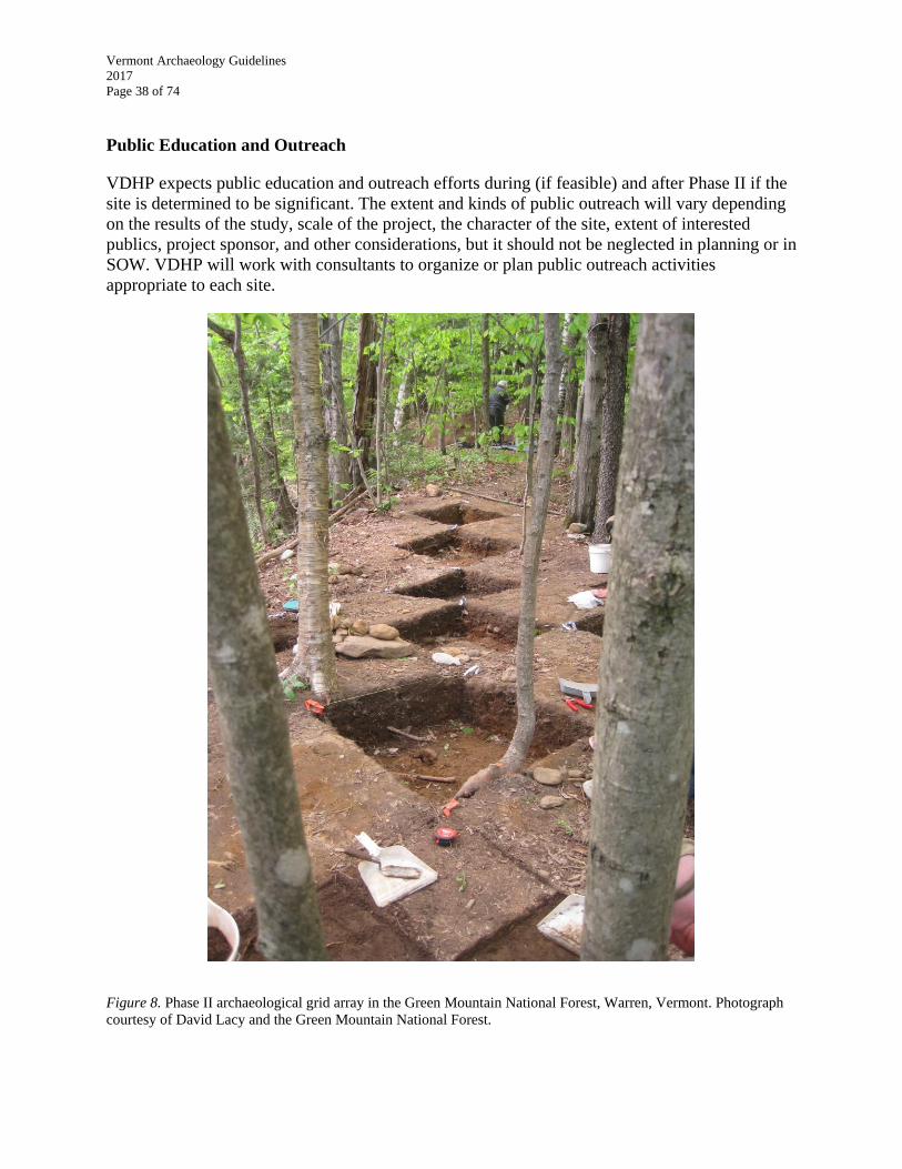
Vermont Archaeology Guidelines
2017
Page 38 of 74
Public Education and Outreach
VDHP expects public education and outreach efforts during (if feasible) and after Phase II if the
site is determined to be significant. The extent and kinds of public outreach will vary depending
on the results of the study, scale of the project, the character of the site, extent of interested
publics, project sponsor, and other considerations, but it should not be neglected in planning or in
SOW. VDHP will work with consultants to organize or plan public outreach activities
appropriate to each site.
Figure 8. Phase II archaeological grid array in the Green Mountain National Forest, Warren, Vermont. Photograph
courtesy of David Lacy and the Green Mountain National Forest.
Vermont Archaeology Guidelines
2017
Page 39 of 74
EVALUATING SITE SIGNIFICANCE
National Register Criteria
Archaeological investigations conducted under federal and state regulatory requirements seek to
identify significant archaeological sites. A significant site meets the criteria for inclusion in the
State and/or National Registers of Historic Places. In regulatory parlance, these sites are
considered “eligible”. Both registers use the National Register criteria for evaluating
significance:
Criterion A: Sites that are associated with events that have made a significant
contribution to the broad patterns of our history.
Criterion B: Sites that are associated with the lives of persons significant in our past.
Criterion C: Sites that embody the distinctive characteristics of a type, period, or method
of construction, or that represent the work of a master, or that possess high artistic values,
or that represent a significant and distinguishable entity whose components may lack
individual distinction.
Criterion D: Sites that have yielded, or may be likely to yield, information important in
prehistory or history.
Bulletin How to Apply the National Register Criteria for Evaluation sets out two requirements
for Criterion D that are especially relevant:
1. The site must he, or have had, information sufficient to contribute to our
understanding of human history or prehistory, and
2. The information must be considered important.
The United States Department of the Interior’s National Register program has published several
bulletins as tools to help guide archaeologists, agencies, managers, and others in evaluating
archaeological site significance:
How to Apply the National Register Criteria for Evaluation
National Register Guidelines for Evaluating and Registering Archeological Properties
(2000)
National Register Guidelines for Identifying, Evaluating and Registering Historic
Mining (1992)
National Register Guidelines for Nominating Historic Vessels and Shipwrecks to the
National Register of Historic Places (no date)
National Register Guidelines for Evaluating and Documenting Traditional Cultural
Properties (rev. 1998)
These bulletins and others can be downloaded from the National Park Service web site at
http://www.nps.gov/Nr/publications/index.htm.
Vermont Archaeology Guidelines
2017
Page 40 of 74
Assessing site significance is often a cumulative process in which more and more data is
collected to reach the point where significance can be established. Although that point can
sometimes only be reached after Phase II investigation, at other times significance can be
established sooner, perhaps even after the ARA.
Although a determination of eligibility is itself sufficient to make regulatory decisions, VDHP
encourages consultants to prepare formal nominations for the State and/or National Registers.
VDHP will be happy to assist consultants in their preparation. All nominations must be presented
to the Vermont Advisory Council on Historic Preservation (Advisory Council) in coordination
with VDHP. The Advisory Council, a volunteer board appointed by the governor to execute a
number of preservation activities under federal and state laws, qualifies as the Vermont state
review board required under the National Historic Preservation Act of 1966 and the annual
Historic Preservation Fund Grant. The seven members evaluate and recommend historic
resources for listing in the National Register of Historic Places. Under state law, the Advisory
Council also approves properties for inclusion in the State Register of Historic Places and
comments on the significance of historic properties under Act 250, and on the effects of state-
funded projects that involve historic and archaeological resources.
Historic Contexts
Historic contexts provide a necessary framework for discovering, investigating, evaluating, and
managing all kinds of archaeological sites. They are a cornerstone of the Secretary of the
Interior’s Standards and Guidelines because they:
Provide the framework for the current state of knowledge about a type of resource
or related categories of resources.
Provide the basis for understanding expected site types, their location, age, size,
and their expected data classes within a given geographic area.
Provide the basis for evaluating the relative significance of sites of the same or
similar type.
Describe the relationship of individual historic resources to other similar
resources or to related resources.
Tell the unifying story about a category or type of resource.
A site is not necessarily significant just because it fits into and can be described within an
historic context. The site must also meet the considerations described below.
Integrity
A site must, at minimum, possess integrity show its significance. The National Register criteria
require that a site possess integrity of location, design, setting, materials, workmanship, feeling,
and/or association. To retain historic integrity, a property will always possess several, and
usually most, of these aspects. The National Register Bulletin How to Apply the National
Register Criteria for Evaluation provides detailed guidance on the complex topic of integrity. In
addition, the National Register Bulletin National Register Guidelines for Evaluating and
Registering Archeological Properties provides a detailed discussion of the various aspects of

Vermont Archaeology Guidelines
2017
Page 41 of 74
integrity, specific integrity requirements for the four individual significance criteria, and many
useful examples. In particular, the guidelines note that integrity of association is especially
relevant under Criterion D. Integrity of association is measured in terms of the strength of the
relationship between the site’s data or information and the important research questions.
Site’s with excellent integrity may be likely or known:
to have intact features/deposits that are temporally and spatially distinct.
discrete deposits and/or assemblages that are not feature deposits but that preserve
the spatial arrangement of past activities.
catastrophic destruction resulting in the encapsulation of the site.
Establishing Precontact Site Significance
Although precontact archaeological sites may be eligible for inclusion in the National Register
under Criteria A, B, and C, their significance is most often established under Criterion D.
Extensive site investigations in Vermont have lead VDHP to conclude that a precontact site will
usually meet Criterion D if it has the following characteristics:
Integrity; and
Answers specific, detailed questions that are important to understanding
Vermont’s precontact or contact period and can be justified as having value to the
public; and
Contains multiple categories of data.
The Site Must Be Able to Answer Specific, Detailed Questions Important to Understanding
Vermont Precontact and Contact Period History
The broad categories outlined below provide a baseline for examining a precontact site’s
potential significance in Vermont. Example questions are provided below in each category for
illustrative purposes. These are by no means exhaustive. To adequately address these research
questions, sites must at a minimum contain multiple categories of relevant data and
characteristics. Evaluations of site significance must be as specific as possible in relating a
research question or questions to the available site data.
Adaptation:
How did changes in climate or regional environment affect people living in what
is now Vermont at specific periods in the past?
How and why did specific technologies enable humans to adapt to specific
environmental conditions or social or cultural changes over time?
o What caused these changes?
How and when did contact with Europeans effect Native Americans living in
Vermont?

Vermont Archaeology Guidelines
2017
Page 42 of 74
Chronology:
How do radiocarbon dates (or other dating mechanisms) inform the culture-
historical records?
How do the diagnostic artifacts from the site agree with known local and regional
taxonomies and radiocarbon sequences?
Can the site contribute to refinements in culture-historical indices in particular
artifact classes?
Technology
How were specific artifacts and artifact classes manufactured and utilized?
Were particular pots or pottery styles used for particular foods or food products?
Why and how were certain lithic materials procured and utilized in a given
context?
Were particular artifacts or artifact classes utilized in ritual contexts? If so, how?
Communication/Exchange/Trade:
How did Native American groups communicate with other regional and extra-
regional groups?
What items were exchanged?
o What are the origins of the raw materials and finished goods being
exchanged?
What forms of exchange were taking place? What were the mechanisms of
exchange?
Human Settlement Systems:
How many people lived in Vermont during specific time periods in the precontact
past?
o Did these numbers change significantly over time? If so, why?
How did people position themselves onto the landscape seasonally, yearly, and
generationally?
How and why did these settlement systems change?
Subsistence and Subsistence Systems:
What were the primary and secondary food items available to Native American
groups at specific periods in the past?
o How were they procured, processed, and prepared?
How did the specific attributes of these food items shape the settlement and
procurement systems of Native Americans at specific periods in the past?
How did agriculture develop in Vermont?
o When?
o Where?
o Did the introduction of agriculture change the character of the lifeways of
Vermont’s Native people?
Vermont Archaeology Guidelines
2017
Page 43 of 74
Socio-political Organization:
What was the social structure of particular Native American groups at specific
periods in the precontact past?
Were there different, and separate, Native American cultural communities in
Vermont during particular precontact and early contact periods?
o If yes, where were these communities located? How did they interact?
What did they have in common? What were their differences? How do we
recognize them in the archaeological record?
Was there ethnic continuity in Vermont’s native people over the entire pre-contact
period?
o If yes, were there breaks/gaps in that continuity?
o If no, what ethnic differences, changes existed?
Belief System:
Does the archaeological site contain artifacts or contexts that connote ritual or
religious activities?
What is the character of ritual or religious activities at specific periods in the past?
Where are Native American ritual sites located? Did their locations change over
time?
Environmental Change:
How did Vermont’s environments and climate change through time and how did
Native people adapt to these changing conditions?
What was the distribution of native flora and fauna (including native fish species)
over time, and how did these affect Native American procurement and use cycles?
The Site Must Contain Multiple Categories of Data
A site must contain, or be likely to contain, multiple data categories sufficient to address
important research questions about Vermont’s ancient or historic past. Assessing site
significance is often a cumulative process in which more and more data is collected to reach the
point where significance can be established.
Data categories are synthesized by VDHP into a straight-forward matrix, which is then presented
to the Vermont Advisory Council on Historic Preservation for formal nominations to the State
Register of Historic Places or for eligibility for the National Register of Historic Places.
Although consultants are not required to fill out this matrix, they should be mindful that the
information in their submittals to VDHP will be utilized to prepare the matrix for presentation to
the Advisory Council, and should therefore be as straightforward as possible
Historic Site Significance
For purposes of regulatory archaeology in Vermont, an historic site must involve an assemblage
or cluster of data sets that usually includes foundations, ruins, or some type of structural remains,
and/or features, deposits, and other man-made alterations to the landscape that can be
investigated using a combination of historic research and archaeological investigations to
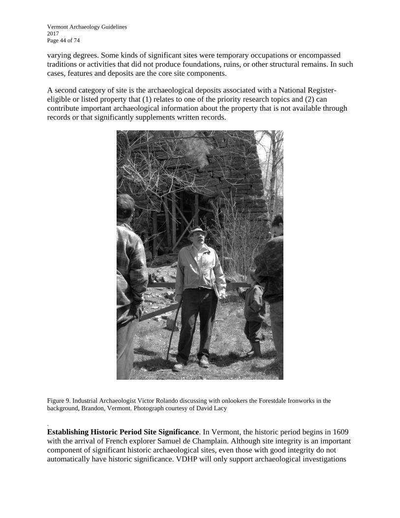
Vermont Archaeology Guidelines
2017
Page 44 of 74
varying degrees. Some kinds of significant sites were temporary occupations or encompassed
traditions or activities that did not produce foundations, ruins, or other structural remains. In such
cases, features and deposits are the core site components.
A second category of site is the archaeological deposits associated with a National Register-
eligible or listed property that (1) relates to one of the priority research topics and (2) can
contribute important archaeological information about the property that is not available through
records or that significantly supplements written records.
Figure 9. Industrial Archaeologist Victor Rolando discussing with onlookers the Forestdale Ironworks in the
background, Brandon, Vermont. Photograph courtesy of David Lacy
. Establishing Historic Period Site Significance. In Vermont, the historic period begins in 1609
with the arrival of French explorer Samuel de Champlain. Although site integrity is an important
component of significant historic archaeological sites, even those with good integrity do not
automatically have historic significance. VDHP will only support archaeological investigations
Vermont Archaeology Guidelines
2017
Page 45 of 74
of historic period archaeological sites during the regulatory process if they have a very high
likelihood of providing important information that cannot be obtained from other sources.
In contrast to precontact sites that can normally only be discovered and studied through
archaeological investigation, many kinds of historic period sites can be understood through
historic maps, photos, drawings, written records and, sometimes, oral histories. For these kinds
of historic sites, it is critical to ask if they might have archaeological significance and how
archaeological methods at the site can significantly and measurably improve our understanding
of Vermont’s history. In some cases, VDHP may recommend photographic documentation and
background research in lieu of or in addition to excavation, particularly where structural remains
are present.
VDHP has developed several policies about historic period archaeological sites. A site shall be
studied archaeologically as part of the regulatory process if:
It addresses or is likely to address in a significant way the priority research topics
listed in these Guidelines;
It has the potential to generate information that adds to, significantly augments, or
overturns the written and archival record; and/or
It addresses research questions significant to a broad audience.
Priority Research Topics to Help Evaluate Significance of Historic Period Sites
The following research topics were identified by VDHP as priorities because they may be
meaningfully addressed through archaeological study. If a potential or identified historic period
site can address these topics and related research questions, the site may be recommended for
further investigation through the regulatory process.
The research topics listed below are general. They are intended to be used as a guide to assist in
determining site significance. Compelling sites that do not fall into these categories may
certainly still be considered by VDHP if they demonstrate a likelihood of providing significant
information to a community, the state, or the nation:
Native people and their communities after European contact.
17th and 18th century military history.
Revolutionary War, War of 1812, and Civil War engagements or associated
infrastructure in Vermont.
Abandoned communities (Vermont’s ghost towns).
18th century French in Vermont.
Early Euro-American settlement (ca. 1760-1800, although may be later in
northern Vermont), including farmstead economy and technology, industry and
commerce, health and nutrition, and transportation.
Pre-1870 industries and commercial enterprises.
Information about Vermont’s underrepresented ethnic and minority groups.
Vermont’s maritime history.
Unwritten stories of important Vermonters (pre-1900).
Unique, rare, highly unusual, or exceptional federal, state, and local public works.
Vermont Archaeology Guidelines
2017
Page 46 of 74
Unique, rare, highly unusual, or exceptional sites.
Involving the Public
Beyond simply engaging the landowner, the regulations that implement Section 106 of the
National Historic Preservation Act, 36 CFR 800, require enhanced public participation as early
as possible in project planning. Section 800.2 (d) of the regulations requires that the federal
agency or its delegate (sometimes the archaeological consultant) seek and consider the views of
the public. In accordance with 800.2 (d) (1), the extent and nature of the public should reflect the
scale and complexity of the project and its effects, the relationship of the federal government to
the project, and likely public interest or controversy, among other considerations. VDHP can
assist in identifying potential public that may have an interest in the project.
Vermont Archaeology Guidelines
2017
Page 47 of 74
PHASE III INVESTIGATION: DATA RECOVERY STUDY
Phase III Data Recovery is undertaken when a significant site has been identified within a project
APE and cannot be avoided through project redesign. VDHP uses the federal Advisory Council
on Historic Preservation’s Recommended Approach for Consultation on Recovery of Significant
Information from Archeological Sites for guidance on data recovery investigations in both
federal and state projects.
The primary goals for Phase III Data Recovery are to:
Recover the maximum significant cultural, environmental, methodological, and
interpretive information and values from the site within the APE before it is
destroyed in whole or in part.
Meet the objectives of the Research Design.
Provide a high level of public education and outreach to ensure that the proposed
destruction of the site provides maximum benefits to a wide audience.
The Guidelines for Phase I and Phase II investigations set out the core requirements for Phase III
investigation and establish both the foundation and framework for this most intensive and
intrusive level of archaeological study. The following are supplementary requirements for the
Phase III.
Additional Research Design Requirements for Phase III
The Phase III Research Design should:
Meet the Research Design Standards (see Resign Design).
Integrate the appropriate Phase I and Phase II Research Design requirements.
Provide a detailed discussion of the research topics and questions to be addressed.
Discuss the types of data that must be gathered in order to address these topics
and questions.
Discuss strategies and methods for recovering the needed data.
Discuss methods of analyses and interpretation.
Identify interdisciplinary experts who may participate in the study, as applicable.
Phase III Scope of Work
Phase III SOW shall meet the general requirements outlined above and shall describe:
Anticipated report format(s), content, and potentially public distribution plan.
Anticipated analytical techniques (such as radiocarbon dating and
paleobotanical/paleofaunal analyses).
Proposed public education, outreach programs, and publications.
All personnel and interdisciplinary experts who will participate in the
investigation.
Detailed schedule for carrying out all aspects of the study.
Vermont Archaeology Guidelines
2017
Page 48 of 74
Detailed curation plan for all artifacts, records, and associated materials derived
from the site excavations.
Detailed budget (not usually submitted to VDHP).
Field Investigations and Data Analyses
Proposed field methods should be adequate to efficiently recover as much of the site within the
APE as possible and to answer or address the questions articulated in the research design. These
methods may include, but are not limited to, block excavations around features and artifact
concentrations, deep testing, remote sensing studies, and so forth. Phase III archaeological
investigations should be based upon the minimum 50 x 50 cm square sample unit, no matter how
large the blocks based upon this sample unit ultimately become. Test pits and test units must be
screened through 1/8” mesh unless alternative methodologies have been approved. If the Phase
III data recovery excavation is occurring at a location with clay soils, defloculation/water
screening procedures may have to be employed on site. Please consult with VDHP about this
possibility.
For Phase III excavations in non-depositional settings, stripping of the plowzone may be
appropriate within the APE where large concentrations of sub-plow zone features have been
previously documented during the Phases I and II excavations. Please contact VDHP to discuss
this possibility prior to submitting a SOW.
For precontact archaeological sites, radiocarbon (C14) dating and paleobotanical/paleofaunal
analyses should be undertaken whenever possible at the Phase III level. In order to derive
material for these analyses, VDHP expects that some or all of the soil from identified cultural
features be processed by flotation/water screening. Phase III budgets should include costs for
flotation/water screening, radiocarbon dating and paleobotanical/paleofaunal analyses in
anticipation that suitable material will be recovered.
Data generated during Phase III data recovery should not be considered in isolation. Rather,
analyses of data recovered during the Phases I and II studies should be integrated into the Phase
III analyses, findings, methodological assessments, and interpretations. Additional analyses, or
even re-analysis, of some or all of the Phases I and/or II data may be necessary at this level of
study.
Documenting Results
In addition to the guidance provided for Phase I EOF Letters above, the following are special
considerations for Phase III EOF Letters:
Identify and describe any portion of the site that:
o was not subject to data recovery; or
o continues to contain significant information subsequent to data recovery;
and
o lies outside of the project limits.
Recommend measures to be taken by the project sponsor to protect the site during
construction if destruction of those portions of the site is avoidable.
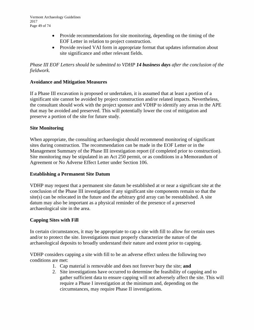
Vermont Archaeology Guidelines
2017
Page 49 of 74
Provide recommendations for site monitoring, depending on the timing of the
EOF Letter in relation to project construction.
Provide revised VAI form in appropriate format that updates information about
site significance and other relevant fields.
Phase III EOF Letters should be submitted to VDHP 14 business days after the conclusion of the
fieldwork.
Avoidance and Mitigation Measures
If a Phase III excavation is proposed or undertaken, it is assumed that at least a portion of a
significant site cannot be avoided by project construction and/or related impacts. Nevertheless,
the consultant should work with the project sponsor and VDHP to identify any areas in the APE
that may be avoided and preserved. This will potentially lower the cost of mitigation and
preserve a portion of the site for future study.
Site Monitoring
When appropriate, the consulting archaeologist should recommend monitoring of significant
sites during construction. The recommendation can be made in the EOF Letter or in the
Management Summary of the Phase III investigation report (if completed prior to construction).
Site monitoring may be stipulated in an Act 250 permit, or as conditions in a Memorandum of
Agreement or No Adverse Effect Letter under Section 106.
Establishing a Permanent Site Datum
VDHP may request that a permanent site datum be established at or near a significant site at the
conclusion of the Phase III investigation if any significant site components remain so that the
site(s) can be relocated in the future and the arbitrary grid array can be reestablished. A site
datum may also be important as a physical reminder of the presence of a preserved
archaeological site in the area.
Capping Sites with Fill
In certain circumstances, it may be appropriate to cap a site with fill to allow for certain uses
and/or to protect the site. Investigations must properly characterize the nature of the
archaeological deposits to broadly understand their nature and extent prior to capping.
VDHP considers capping a site with fill to be an adverse effect unless the following two
conditions are met:
1. Cap material is removable and does not forever bury the site; and
2. Site investigations have occurred to determine the feasibility of capping and to
gather sufficient data to ensure capping will not adversely affect the site. This will
require a Phase I investigation at the minimum and, depending on the
circumstances, may require Phase II investigations.

Vermont Archaeology Guidelines
2017
Page 50 of 74
Examples when capping will not be considered:
burying a site under a permanent, trafficked road such as a highway; or
burying a site under a permanent building on slab.
In these examples, the site is considered forever inaccessible for research because its
characteristics may be disturbed in unknown ways from vibrations, weight, chemicals, road salt,
construction, and destruction, etc.
Phase III Investigation Reports
Basic requirements for documenting Phase III investigations are set forth in the Secretary of the
Interior’s Standards and Guidelines for Archeological Documentation. The following
requirements supplement the federal guidance:
Phase III reports contain new and important information and should be available to as many
scholars and interested individuals as possible. This is especially important because the site(s)
investigated will be partly or wholly destroyed. VDHP, the project sponsor, and consulting
archaeologist will discuss and negotiate the format(s) of the final report and methods for report
distribution, if applicable. The project sponsor is usually responsible for distributing the reports
to the community, consulting parties, interested persons and organizations, colleagues, and
public libraries, as appropriate. VDHP can assist by recommending a report distribution list.
Standards for Phase III Reports
Format of the Phase III report will be discussed with VDHP and the project
sponsor, and agreed to when the SOW is developed.
Report may be special in content, design, and format. For example, different
specialists may author separate chapters on general overviews, on specific
research topics and questions, on specific data categories, on specific
methodological experiments and innovations, etc.
Management Summary and Recommendations
Briefly identify and describe any portion of the site that was not subject to data
recovery, or continues to contain significant information subsequent to data
recovery and lies outside of the project limits. Recommend measures to be taken
by the project sponsor to protect such parts of the site during construction if
destruction is avoidable.
Provide any appropriate recommendations for monitoring of site(s), depending on
the timing of the report in relation to project construction.
Provide suggestions for long-term measures to ensure preservation of the site in
perpetuity.
Conclusions
Discuss contributions this investigation has made to state, regional or national
precontact or post-contact history.
Revise and refine the relevant historic context(s) and current information on the
normative characteristics of this type of archaeological site.

Vermont Archaeology Guidelines
2017
Page 51 of 74
Provide recommendations for updating or revising research questions, goals and
priorities in the Vermont State Historic Preservation Plan.
Discuss any ongoing or proposed preservation efforts or programs related to site
protection, structures documentation, special studies or analyses, site stabilization,
etc.
Education and Outreach
Describe the public outreach programs resulting from the study, including
benefits, number of people who actively participated in such efforts, issues and
how they were resolved, and identify long-term, in progress, and/or yet-to-be-
completed education and outreach programs.
Appendices
Technical appendices may be formatted into a separate volume so that it can be
distributed only to those interested in the supporting data such as soil profiles,
catalog forms, etc.
o Soil profiles should be provided for all test units or for a representative
sample, depending on the number excavated and the variation
encountered.
Any ancillary studies such as geomorphological reports, special analyses, etc.,
should be included in the main report volume if they are of broad interest.
A copy of the Memorandum of Agreement, VAI and any other relevant project
correspondence should be included in technical appendices.
Special Considerations for Phase III Reports
Quarterly, Semi-Annual or Annual Updates. Brief summary reports may be required to be
submitted quarterly, semi-annually, or annually to VDHP and the project sponsor and, if
appropriate, to the community and other relevant parties. These reports, if requested, shall
include, but not be limited to, the following information:
1. summary of data analysis and interpretation tasks completed;
2. summary (or examples) of interesting or new findings;
3. status of current public education and outreach efforts; and
4. scheduling concerns, if any.
VDHP considers all reports to be drafts subject to comment and revision. However, please do not
mark reports submitted to VDHP as “draft” or other similar designation. Instead, VDHP will
review a Phase III report and offer editorial comments as appropriate within 60 days of receipt.
Consultants should then address those comments within 60 days with a revised report or provide
a written explanation if the consultant disagrees with the comments.
If VDHP does not offer comments on a Phase III report within 60 days, it is considered a final
concluding document.
Public Education and Outreach. The highest level of public education and outreach is required
in the course of Phase III investigations to ensure that the proposed destruction of a site provides
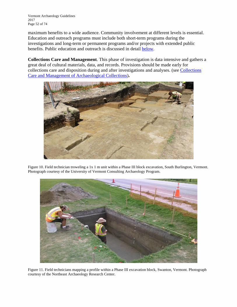
Vermont Archaeology Guidelines
2017
Page 52 of 74
maximum benefits to a wide audience. Community involvement at different levels is essential.
Education and outreach programs must include both short-term programs during the
investigations and long-term or permanent programs and/or projects with extended public
benefits. Public education and outreach is discussed in detail below.
Collections Care and Management. This phase of investigation is data intensive and gathers a
great deal of cultural materials, data, and records. Provisions should be made early for
collections care and disposition during and after investigations and analyses. (see Collections
Care and Management of Archaeological Collections).
Figure 10. Field technician troweling a 1x 1 m unit within a Phase III block excavation, South Burlington, Vermont.
Photograph courtesy of the University of Vermont Consulting Archaeology Program.
Figure 11. Field technicians mapping a profile within a Phase III excavation block, Swanton, Vermont. Photograph
courtesy of the Northeast Archaeology Research Center.

Vermont Archaeology Guidelines
2017
Page 53 of 74
PUBLIC EDUCATION & OUTREACH
Archaeological studies in Vermont need to interpret project results for the public benefit and
present those findings to the public. The expected level of education and outreach increases for
each successive phase of investigation and depends on project scale, investigation results, project
sponsor, and anticipated affects to one or multiple sites. Archaeological consultants are
encouraged to adopt new and innovative methods as well as those that are described below if
these techniques could be used profitably in education and outreach endeavors. Moreover,
VDHP encourages consultants to publish important results in appropriate scholarly publications,
and will work with consultants toward that end.
Public education supplements data recovery as mitigation for the destruction of all or part of a
significant archaeological site. The extent of public education and outreach efforts needed to
achieve mitigation is based on the extent of the loss of archaeological information and the site’s
significance. This section is intended to provide guidance to project sponsor and consultants who
generally must take the lead role in all aspects of education and outreach. The education and
public outreach components of significant sites where mitigation occurs should be decided upon
in consultation with VDHP.
General Standards for Public Education and Outreach:
Landowners, towns (both local government and community groups), educators,
students, and the general public are likely targets for education and outreach.
Scholarly publication is strongly encouraged whenever dissemination of the data
is determined to be significant for the archaeological community.
To the greatest extent possible, education and outreach projects and programs
should be conducted in consultation with the local community and other
interested parties both during planning and implementation.
Education and outreach activities should be coordinated with Native Americans as
appropriate.
Exceptional sites or special projects may require enhanced education and outreach
as a component of the Phase I investigation.
Historic archaeological sites may be suited to different types of education and
outreach efforts.
Sites that need to be protected from public access may need special kinds of
education and outreach efforts.
Education & Outreach for Landowners
Private and municipal landowners should be made aware of all excavations occurring on their
land and all materials that archaeologists derive from them. The artifacts are the landowner’s
property; usually even in cases where the applicant (such as a utility conducting construction in a
transmission corridor) has an easement. Sometimes, such as during powerline or pipeline
projects, landowner contact must be mediated by the applicant, but that does not absolve the
applicant or consultant from keeping the landowner informed in a timely manner. Open
disclosure will also facilitate potential donation of artifacts and related materials to VAHC at the

Vermont Archaeology Guidelines
2017
Page 54 of 74
conclusion of the project. In certain cases, a public meeting for site landowners and other
interested persons may also be appropriate depending on the results of the impacts, mitigation
measures, and scope of the study
As appropriate, stewardship information can be provided to landowners to promote long-term,
voluntary site conservation. This may include information on conservation non-profit entities
such as the Archeological Conservancy, Vermont Land Trust, local conservation non-profits,
among other tools and techniques to voluntarily preserve site in perpetuity. Stewardship
information on these organizations is available from VDHP or directly through these
organizations’ website.
Education & Outreach for the Municipality
Local governments, historic preservation commissions, and Certified Local Government
commissions (CLG), where they exist as appropriate, should be made aware of the
archaeological investigation. (http://grants.cr.nps.gov/CLGs/CLG_Search.cfm). The notification
information should include project location, anticipated schedule, and site tour information. This
can be accomplished through written notification. However, attending select board, planning
commission, conservation commission, historic preservation commission, CLG
board/commission, or regional planning commission meetings can be very helpful, especially on
large projects and during Phase II and Phase III investigations.
At the conclusion of the archaeological study, site information may be provided to the
municipality dependent on the project sponsor’s approval. Information may include site maps,
GIS data sets, and investigation report. – remove site maps
A presentation to the select board, planning commission, historic preservation commission, CLG
board/commission, and/or regional planning commission may be appropriate depending on the
results of the investigation.
Recommended Projects and Programs
The following list illustrates some examples of recommended education and outreach projects.
Some of these examples incorporate recent advances in technology. Please contact VDHP in the
development of scopes of work for Phase II and Phase III education and outreach programs.
VDHP can provide guidance and information on a variety of topics, provide useful ideas, and
samples of excellent non-technical publications from Vermont and other states.
Exhibits (temporary/traveling/or permanent) at the VAHC or elsewhere
Non-technical books or handbooks
The alteration of a technical report into a general reading report or scholarly
report
Articles in other popular local, regional, or national magazines
Videos
Social Media
Press releases
Community archaeology projects using adult and youth volunteers or students
(field schools, summer camps)
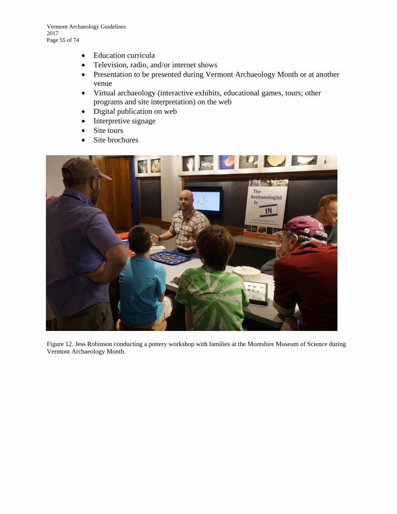
Vermont Archaeology Guidelines
2017
Page 55 of 74
Education curricula
Television, radio, and/or internet shows
Presentation to be presented during Vermont Archaeology Month or at another
venue
Virtual archaeology (interactive exhibits, educational games, tours; other
programs and site interpretation) on the web
Digital publication on web
Interpretive signage
Site tours
Site brochures
Figure 12. Jess Robinson conducting a pottery workshop with families at the Montshire Museum of Science during
Vermont Archaeology Month.
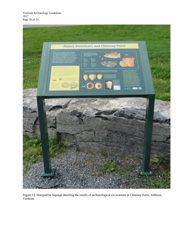
Vermont Archaeology Guidelines
2017
Page 56 of 74
Figure 13. Interpretive Signage detailing the results of archaeological excavations at Chimney Point, Addison,
Vermont.
Vermont Archaeology Guidelines
2017
Page 57 of 74
CARE AND MANAGEMENT OF ARCHAEOLOGICAL COLLECTIONS
Archaeological collections include artifacts, soils and feature samples, floral and faunal data,
records, reports, photographs, digital data and any other data sets recovered from an
archaeological site or generated as a result of an archaeological excavation, or that were used to
analyze the site or contribute to the significance of a site. Many of these materials will require
some form of care now and in the future.
Archaeological collections should, to the greatest extent possible, be accessible in perpetuity for
research, education, and public interpretation. Because the excavation of sites is a destructive
process, the recovered material and associated archives are often all that remains to reconstruct
and interpret the site once it, or parts of it, are destroyed. Care and management of collections to
allow future research, education, and public interpretation is thus a key part of any
archaeological investigation. Moreover, for some archaeological excavations, future curation and
public accessibility may be a specific requirement in Memoranda of Understanding or in SOW.
Federal agencies who own land or who fund, permit, license, or otherwise provide assistance to
projects are guided by federal law, regulations and guidelines in their obligation to care and
manage collections (specifically, 36 CFR 800, the Secretary of the Interior's Standards and
Guidelines for Archeological Documentation, the Archeological Resources Protection Act, and
36 CFR 79).
State agencies that own land or sponsor archaeological investigations on their lands are guided
by Title 22 of Vermont Statutes Annotated, Chapter 14 (especially sections 762 and 764).
Section 762 of 22 VSA 14 states that “all information and objects deriving from state lands shall
remain the property of the state and be utilized for scientific or public educational purposes.”
Section 764 of 22 VSA 14 requires that:
all specimens so collected under permit shall be the permanent property of the state and
that the state archeologist shall make prior arrangements for the disposition of specimens
derived from the activities in an appropriate institution of the state or for the loan of the
specimens to qualified institutions in or out of the state.
Federal agencies generally impose their own obligations for care and management of collections
on recipients of federal funds or licenses through contract, Memoranda of Agreement,
Programmatic Agreement, or other understanding. The Vermont Archaeology Heritage Center
should be considered as a repository for undertakings on federal land or with federal money (see
below).
If a Site is Located on Private Land
All archaeological materials collected from private land in the course of archaeological
investigations are the property of the landowner unless explicitly donated to a suitable
organization that will care for and manage the collections. It is important that consulting
archaeologists and/or the project sponsors inform the landowner of their legal entitlement to the

Vermont Archaeology Guidelines
2017
Page 58 of 74
archaeological materials. Inquiring of the landowner at the earliest opportunity about their
intentions for the collection is highly recommended. If the landowner so desires, some or all of
the material must be returned to the landowner after data analyses.
The Vermont Archaeology Heritage Center (VAHC) has functioned as the primary repository for
archaeological collections derived from compliance work since 2012. Consulting archaeologists
and/or the project sponsors should make landowners aware of this facility and the long-term
benefits of their donation for research and education. A landowner’s desire to retain artifacts may
affect the SOW and mitigation strategies undertaken for Phase III data recovery excavations.
Donating an archaeological collection and the associated care fee (unless waived by the State
Archaeologist) may have potential tax benefits for a landowner. Private developers may wish to
consult a tax lawyer or accountant about this possibility.
Vermont Archaeology Heritage Center
For many years, Vermont's archaeological collections were housed in various locations across
Vermont and in adjacent states. Many artifacts were stored on a temporary basis at the University
of Vermont or with other consulting and academic organizations. Beginning in the late 1990s,
the Vermont Agency of Transportation Archaeology (VTrans) and VDHP worked to bring the
collections and archives generated as a result of regulatory archaeology back to Vermont and
into a central repository. In 2012, VAHC was opened in Barre at 60 Washington Street in a
portion of the rehabilitated Spaulding Graded School building. VAHC currently leases 1,850
square feet of space as part of a Memorandum of Understanding with the Vermont Historical
Society (VHS).
VAHC’s collections policies and procedures document is available at this website.
Scope of the Collections. VAHC is committed to preserving the state’s archaeological heritage
according to the national standards of collections care described in Code of Federal Regulations,
Title 36, Part 79 (36 CFR 79). As of May 2015, VAHC began the curation of cultural material,
archives and photographs from over 750 archaeological sites. These collections cumulatively
represent over 13,000 years of Vermont’s human history and reflect over 40 years of research by
archaeologists working across the state.
Priority is given to collections recovered, analyzed and acquired in a professional and ethical
manner, especially from consultants as a result of federal and/or state laws and statutes. Curation
fees associated with these projects fund their future care. In some cases, materials of unusual
quality that lack contextual information or associated monies may be accepted for permanent
curation. VAHC also accepts objects, books, and archival materials that will contribute to its
mission by enhancing its educational collections, research library, or photographic archive on a
case-by-case basis.
Charges and Deeds of Gift. VAHC charges a standard per-box fee of $500.00 (2013 Statute)
for permanent curation. Collections derived from excavations conducted on state-owned land
must be curated at VAHC, and monies should be budgeted for their care in any scope of work.
Vermont Archaeology Guidelines
2017
Page 59 of 74
VAHC cannot accept any collections excavated from private land without a signed Deed of Gift
from the landowner. A copy of this form is appended at the end of this document (Appendix III).
VAHC has a manual for preparing donations for delivery (see VAHC’s website)
Native American Burials (Including Human Remains and Funerary Objects) and Non-
Native American Human Remains. As noted above, it is against the law to excavate an
unmarked burial in Vermont, except under the provisions outlined in Title 18, Chapter 107 of the
Vermont Statutes, and specifically 18 VSA §5212b. If the burial is in imminent danger of
disturbance by natural or human processes, respectful removal may be conducted in consultation
with VDHP and any affiliated tribe(s). VAHC does not accept Native American human remains
or associated burial goods unless with the express consent and coordination with the affiliated
tribe(s), if applicable. Unassociated funerary objects, sacred objects, and objects of cultural
patrimony, as defined in Native American Graves Protection and Repatriation Act (NAGPRA)
(25 USC, §§3001-3013), will be curated on a case-by case-basis, in consultation with affiliated
tribe(s), if applicable. If a decision is made to reinter such objects, additional documentation may
be required. Historic human remains of non-Native descent may be accepted pursuant to state
laws on a temporary basis until they can be reinterred in an appropriate cemetery and town.
Field Recovery, Sampling, and Culling/Discard Policies. Given the continual advances in
analytical techniques for archaeological materials, the research potential of bulk materials (such
as brick, slag, fire-cracked rock, and soils) is unknown but potentially far greater than supposed
or realized at present. Indiscriminate or ad hoc discard procedures in the field, therefore, are not
recommended. A number of problems arise from collecting and curating large amounts of bulky,
non-diagnostic, and often redundant materials in archaeological repositories, particularly given
the realities of limited storage space in facilities and the money and time associated with their
analysis, quantification, labelling, boxing, and transfer.
Consultants working on any regulated archaeological undertaking in Vermont should consult
with VDHP if they anticipate or encounter situations that may require sampling of bulk materials
in the field to determine whether or not the artifacts will eventually be curated at VAHC.
Moreover, as noted above, consultants should anticipate and prepare for the identification of bulk
materials in research designs and in SOW. In general, if not overly burdensome, all materials
should be collected in the field and any sampling, culling, or discarding should be done after
analysis within the controlled conditions of a laboratory. The State Archaeologist should be
consulted about sampling procedures of definitive cultural material dating to the primary time
period(s) of study if the materials are to be ultimately curated at VAHC. The State Archaeologist
will consider on a case-by-case basis reasonable sampling procedures if the consultant feels that
certain bulk materials are redundant, have limited or no future research potential, or where
sampling would be would be just as or nearly as effective for future research.

Figure 14. Views of the Vermont Archaeology Heritage Center, Barre, Vermont.
Figure 15. Volunteers and temporary employees working at the Vermont Archaeology Heritage Center.
Vermont Archaeology Guidelines
2017
Page 61 of 74
APPENDIX I: SHAPEFILE REQUIREMENTS AND FORMATTING
Shapefile Submittal Requirements
Shapefile refers to a popular geospatial vector data format used in geographic information
systems (GIS) software. The term is somewhat of a misnomer because a shapefile actually
includes a core set of three mandatory file types and may also contain addition file types that
extend functionality and/or interoperability. Although it was originally developed by the ESRI®
Company for use in its own software, it now functions as a (mostly) open standard for use in a
wide variety of GIS software programs and applications (i.e. QGIS). Shapefiles can preserve and
correctly reproject spatially bound vector features, such as points, lines, and polygons,
representing any geospatial entity. In archaeology, for instance, shapefiles may be generated to
depict test units, buffers, project boundaries, etc. and correctly project them over maps or other
raster images. Each shapefile also usually has attributes that describe it, such as name,
description, length, etc. These attributes are stored and referenced in a table associated with the
shapefile. Cumulatively, this descriptive information is referred to as metadata. This metadata
can be used for data analysis, labelling, and reference purposes.
Because geospatial information and the programs that generate them are becoming ubiquitous in
engineering and design, environmental research, academic research, and compliance and project
review, VDHP is now requiring shapefiles be submitted for all archaeological surveys conducted
under applicable state and federal laws. VDHP review of consultant submittals over the past few
years indicates that most, if not all, consultants are already using various GIS and/or CAD
software packages to generate maps and analyze spatial data. As such, the guidance below
merely standardizes shapefile formats and outlines the relevant fields that should be completed in
the attribute table.
After additional infrastructure work and expansion on our map tool in 2016, these shapes will be
available for anyone with password access to the archaeological component of the ORC after
review by VDHP. Moreover, they will enable VDHP to better evaluate environmental variables,
site sizes and many other factors for better predictive modeling and oversight in the future.
Shapefile Formats and Appropriate Metadata
What follows are the minimum shapefiles required by VDHP for regulatory, research and
archival purposes. If additional shapefiles are generated by consultants in the courses of analysis
and reporting, they may certainly submit them to VDHP. To aid consultants, a shapefile .zip
package may be downloaded from the VDHP website that contains all of the shapefiles
explained below. Each shapefile has been prefigured with the appropriate projection (Vermont
State Plane) and fields within the attribute table. If for some reason the consultant wishes to
generate their own shapefiles, they should mirror the format and attribute table fields outlined
below, and the attribute table should be arranged in the order in which they appear below.
Because of its accuracy within the Vermont state borders, VDHP utilizes the Vermont State
Plane coordinate system (meters).
Vermont Archaeology Guidelines
2017
Page 62 of 74
Each shapefile is named by its site number designation followed by an underscore and the entity
being depicted if a site was identified at that location. For instance, a shape depicting the
project’s Area of Potential Effect would be listed as VT-XX-XXXX_APE. The shapefile
templates will be named in this manner and the actual site numbers can be substituted before
submission. If no site was found during a project, the shapefiles should be renamed for the
project title.
Project Area of Potential Effect (VT_XX_XXXX_APE): Polygon shape or shapes depicting the
largest area and greatest extent of the APE of the proposed undertaking. Visual impacts
and other indirect impacts are not included in this area designation. In most cases, this
information is derived from project maps or plans. If the project contains several, discontinuous
project areas, a polygon should be drafted for each one and the appropriate metadata should be
filled out for each.
Each metadata field is described below:
FID: Auto-generated field.
SHAPE: Auto-generated field
COUNTY: County in which project area is located.
TOWN: Town in which project area being depicted is located. If the project area
polygon straddles two or more towns, list the town that contains the majority of
the project area polygon.
PA_NAME: Name given to a specific project based on the applicant or
sponsor’s submittal, or in the absence of that information, an exact address.
Unofficial designation.
SPONSOR: Group(s) or individual(s) responsible for paying for the research
and survey.
JURISDICTION: Legal jurisdiction under which the archaeological survey is
being conducted (e.g. Act 250, Section 248, 22 VSA, Section 106).
SITE_PRES: Field indicating presence or absence of an archaeological site
within the project area boundaries.
SITE_NUM: List VDHP site number(s) given to any previously identified or
newly identified site(s) within the project area. If more than one site is located
within the project area, list them in alpha-numeric order, separated by a comma. If
there was no site identified within the project area, the field should be left blank.
DATE: Auto-generated field; The date the shapefile was created.
NOTES: Any applicable notes about the project area that might be of use in the
future.
Archaeologically Sensitive Area(s) (VT_XX_XXXX_ASA): Polygon shape or shapes depicting
the area(s) that the consultant (with VDHP concurrence) has defined as archaeologically
sensitive within the overall project area. If there is more than one area, the metadata should be
completed for each.
Each metadata field is described below:
FID: Auto-generated field.
Vermont Archaeology Guidelines
2017
Page 63 of 74
SHAPE: Auto-generated field
COUNTY: County in which the archaeologically sensitive area is located.
TOWN: Town in which the archaeologically sensitive area is located. If the
archaeologically sensitive area polygon straddles two or more towns, list the town
that contains the majority of the polygon.
AREA_DES: Consultant’s designation of the archaeologically sensitive area if
there is more than one in a project area (i.e. 1, 2, 3, etc.).
CONSULTANT: Name of the consultant or individual that undertook the project.
DATE: Auto-generated field; date the shapefile was created.
NOTES: Any applicable notes about the sensitive areas that might be of use in
the future.
Surface Collected Artifact(s) (VT_XX_XXXX_SCA): This point shapefile depicts any artifacts
that were recovered as a result of a surface collection survey. Each artifact should be documented
individually as a single point, unless other procedures have been approved by VDHP.
Each metadata field is described below:
FID: Auto-generated field.
SHAPE: Auto-generated field
SITE_NUM: VDHP-assigned site number related to the artifact recovery
PHASE: Phase of archaeological investigation under which the artifact was
identified.
CAT_NUM: Catalog number that the consultant assigned to the artifact.
TYPE: Type of artifact recovered during the surface survey (lithic tool, debitage,
or historic). If something unusual, significant or notable is recovered, please
indicate it in the note field.
CONSULTANT: Name of the consultant or individual that undertook the project.
DATE: Auto-generated field; date the shapefile was created.
NOTES: Any applicable notes about the shape or artifacts that might be of use in
the future.
Transect(s) (VT_XX_XXXX_TR): This line shapefile depicts any transect along which test pits
are excavated at particular intervals. If test pits are excavated within a standardized grid array,
they do not need to be connected by transect lines.
Each metadata field is described below:
FID: Auto-generated field.
SHAPE: Auto-generated field
PHASE: Ph I, Ph 2, Ph 3; Phase of archaeological investigation during which the
transect was excavated.
NAME: Name of the transect as designated by the consultant (e.g. 1, 2, 3).
CONSULTANT: Name of the consultant or individual that undertook the project.
DATE: Auto-generated field; date the shapefile was created.
NOTES: Any applicable notes about the shape that might be of use in the future.
Vermont Archaeology Guidelines
2017
Page 64 of 74
Test unit(s) (VT_XX_XXXX_TU): This polygon shapefile depicts test pits and/or larger test
units excavated during any and/or all phases of archaeological investigation within a particular
project area. Because the Guidelines advise all consultants that the standard minimum test unit
size should be a 50 x 50 cm square, polygon test unit shapes should be predicated upon that
minimum unit size. Test units should not be depicted as a point. They should be drawn with
accurate dimensions using the VDHP-supplied shapefiles or facsimile. Each test pit/unit should
be drawn individually based upon the consultant’s field excavations. For instance, if a consultant
has excavated 20 test pits and three larger, 1 x 1 test units, the test pits should be depicted as
individual 50 x 50 cm squares and the 1 x 1 units should be depicted as four, adjacent 50 x 50 cm
squares. There are several tools in ESRI ArcMap that can simplify the processes of drawing and
layout of these shapes.
Each metadata field is described below:
OBJECTID: Auto-generated field.
SHAPE: Auto-generated field
PHASE: Ph I, Ph 2, Ph 3; Phase of archaeological investigation during which the
test unit was excavated.
NAME: Coordinates of the test pit/test unit as designated by the consultant. Phase
I test pits may be numbers or other designations. Test pits and/or units excavated
within standard grid arrays should be identified by consultant designated X/Y
coordinates.
STATUS: positive/negative; Should indicate whether or not the test unit contains
artifacts or features pertinent to the primary period(s) of archaeological inquiry
(e.g. not incidental modern or historic artifacts).
CONSULTANT: Name of the consultant or individual that undertook the project.
DATE: Auto-generated field; Date the shapefile was created.
NOTES: Any applicable notes about the artifacts that might be of use in the
future.
Other Notes about Shapefile Submissions
A point shapefile will be generated on the ORC Map Tool based upon the Vermont State Plane
Northing and Easting coordinates entered into the VAI site form. The single point allows the
map to be panned and zoomed, while still making the site visible at all scales. When entering in
the coordinates in the site form on the ORC, choose a point in the middle of the site area as
known after excavations within the APE.
The establishment of site boundaries within the APE is also an important step in the
archaeological process. Nevertheless, because of the idiosyncrasies of site deposits and
relationships between loci, etc., there is no standard guidance about site boundaries offered here.
If a site boundary is defined in consultation with VDHP as part of Phase II site evaluation
submittals or Phase III data recovery excavations, however, these boundary polygons should be
submitted to VDHP.
Vermont Archaeology Guidelines
2017
Page 65 of 74
APPENDIX II: ACCIDENTAL DISCOVERY OF ARCHAEOLOGICAL SITES AFTER
PROJECT REVIEW AND/OR DURING PROJECT CONSTRUCTION
This section refers to archaeological sites that are discovered after archaeological review has
been completed and/or after project construction has begun. If human remains are discovered
in the course of archaeological review or during project construction, see above.
Examples of archaeological sites that may be discovered during construction include:
Native American sites that are not anticipated by the general predictive model or
sensitivity assessments.
Unanticipated human remains.
Foundations and other structural remains, such as wells, obscured by fill or later
disturbances.
Deeply buried sites in floodplains that are missed by standard testing methods.
Historic archaeological sites that are not identified on historic maps (Beers,
Wallings, etc.).
Procedure to follow when discoveries are made during Vermont Agency of Transportation
Projects:
Protocols for accidental site discoveries for Vermont Agency of Transportation
(VTrans) projects fall under separate guidance. Immediately contact Dr. Jeannine
Russell, VTrans Archaeology Officer, at (802)-828-3981.
Procedure to follow when discoveries are made in the course of Project Construction for
Non-VTrans Projects:
Stop immediately if previously unidentified archaeological sites are discovered
during project construction.
If the human remains are discovered, see above.
Project sponsor, developer, construction company, or project engineer, as
appropriate, should immediately notify the project’s consulting archaeologist, if
there was one during project planning. If not, the VDHP shall be notified.
When contacted, the consulting archaeologist or VDHP will make a preliminary
assessment of the site’s potentially significant and recommend additional steps to
mitigate the effects of project construction. Depending on the project, the nature
of the discovery and the statutory jurisdiction, VDHP may ask the project sponsor
to retain a consulting archaeologist to assist in development of a treatment plan.
Depending on the statutory jurisdiction of the project (Act 250, state law, or
federal law), the appropriate jurisdictional agency may need to get involved in
discussions to resolve the matter in accordance with their respective authorities.
If the project falls under federal Section 106 jurisdiction, the process set out in 36
CFR 800.11 and 800.13 must be followed.

Vermont Archaeology Guidelines
2017
Page 66 of 74
APPENDIX III: DEED OF GIFT FORM
Deed of Gift
I/we own the property described in the Inventory of Objects (below or attached), and
hereby unconditionally give, donate, bestow and set over unto the State of Vermont
Archaeology Heritage Center, its successors and assigns, said property, to be used or
disposed of in their unrestricted discretion. I waive all present or future rights in, to, or
over said property, its use or disposition.
Signature: ____________________________ Date: __________________
Name: ________________________________
Address: ______________________________
_______________________________
Signature: ____________________________ Date: __________________
Name: ________________________________
Address: ______________________________
______________________________
Inventory of Objects
□ Listed below as follows: □ Listed on attached inventory
*Please review our Mission Statement and Deaccession Policy, which are available on
our website or by request