Embed Size (px)
Citation preview
Guidelines for Climate Impact and Vulnerability AssessmentsRecommendations of the Interministerial Working Group on Adaptation to Climate Change of the German Federal Government
For our Environment

2
Guidelines for climate impact and vulnerability assessments |
Editorial information
Publisher:UmweltbundesamtSection I 1.6 – KomPass – Climate Impactsand Adaptation in GermanyPO Box 14 06D-06844 Dessau-Roßlau Tel: +49 340-2103-0
Contact:Dr. Inke SchauserClimate impact and vulnerability assessmentsPhone: +49 [email protected]
/umweltbundesamt.de
/umweltbundesamt
Authors:Mareike Buth, Walter Kahlenborn (adelphi)Prof. Dr. Stefan Greiving, Dr. Mark Fleischhauer(plan + risk consult)Dr. Marc Zebisch, Dr. Stefan Schneiderbauer(European Academy of Bozen)Dr. Inke Schauser (German Environment Agency)
Edited by:Dr. Esther Hoffmann, Johannes Rupp, Richard HarnischInstitute for Ecological Economy Research
Design:Volker Haese, Dipl. Graphics designer
English translation:NP Services
Publications as pdf:www.umweltbundesamt.de/publikationen
As of February 2017
ISSN 2363-832X (Internet)

3
Guidelines for Climate Impact and Vulnerability AssessmentsRecommendations of the Interministerial Working Group on Adaptation to Climate Change of the German Federal Government
The Interministerial Working Group on Adaptation to Climate Change (IMA Anpassung) of the German Federal Government is headed by the Federal Ministry for the Environment, Nature Conservation, Building and Nuclear Safety (BMUB). The Federal Foreign Office (AA), the Federal Chancellery (BK), the Federal Ministry of Finance (BMF), the Federal Ministry of the Interior (BMI), the Federal Ministry of Labour and Social Affairs (BMAS), the Federal Ministry of Education and Research (BMBF), the Federal Ministry of Food and Agriculture (BMEL), the Federal Ministry of Defence (BMVg), the Federal Ministry for Family Affairs, Senior Citizens, Women and Youth (BMFSFJ), the Federal Ministry of Health (BMG), the Federal Ministry of Transport and Digital Infrastructure (BMVI), the Federal Ministry for Economic Affairs and Energy (BMWi) and the Federal Ministry for Economic Cooperation and Development (BMZ) are represented in the IMA Anpassung. The German Environment Agency (UBA) is the permanent presiding senior authority.

4
Guidelines for climate impact and vulnerability assessments
Contents
1 Introduction . . . . . . . . . . . . . . . . . . . . . . . . . . . . . . . . . . . . . . . . . . . . . . . . . . . . . . . . . . . . . . . . . . . . . . . . . . . . . 6
2 Creating a framework for climate impact and vulnerability assessments . . . . . . . . . . . . . . . . . . . . . . . . . . . 82.1 Objectives and extent of climate impact and vulnerability assessments . . . . . . . . . . . . . . . . . . . . . . 82.2 Vulnerability concepts . . . . . . . . . . . . . . . . . . . . . . . . . . . . . . . . . . . . . . . . . . . . . . . . . . . . . . . . . . . . . . . 102.3 Interactions between technical analysis and normative evaluation . . . . . . . . . . . . . . . . . . . . . . . . . 11
3 Recommendations for carrying out climate impact and vulnerability assessments . . . . . . . . . . . . . . . . . . 143.1 Working step 1: Plan and prepare the assessment . . . . . . . . . . . . . . . . . . . . . . . . . . . . . . . . . . . . . . . 143.1.1 Involving experts from responsible institutions . . . . . . . . . . . . . . . . . . . . . . . . . . . . . . . . . . . . . . . . 143.1.2 Specifying the methodological framework and key terms . . . . . . . . . . . . . . . . . . . . . . . . . . . . . . . . 163.1.3 Specifying scenarios for climate stimuli, spatial exposure and sensitivity . . . . . . . . . . . . . . . . . . . 183.2 Working step 2: Step-by-step execution of the climate impact and vulnerability assessment . . . 223.2.1 Developing impact chains . . . . . . . . . . . . . . . . . . . . . . . . . . . . . . . . . . . . . . . . . . . . . . . . . . . . . . . . . . 223.2.2 Operationalising selected sectoral climate impacts . . . . . . . . . . . . . . . . . . . . . . . . . . . . . . . . . . . . 243.2.3 Evaluating and aggregating climate impacts . . . . . . . . . . . . . . . . . . . . . . . . . . . . . . . . . . . . . . . . . . . 283.2.4 Evaluating adaptive capacity . . . . . . . . . . . . . . . . . . . . . . . . . . . . . . . . . . . . . . . . . . . . . . . . . . . . . . . . 333.2.5 Evaluating vulnerability . . . . . . . . . . . . . . . . . . . . . . . . . . . . . . . . . . . . . . . . . . . . . . . . . . . . . . . . . . . . 343.3 Working step 3: Communicating and using results . . . . . . . . . . . . . . . . . . . . . . . . . . . . . . . . . . . . . . . 36
4 Sources . . . . . . . . . . . . . . . . . . . . . . . . . . . . . . . . . . . . . . . . . . . . . . . . . . . . . . . . . . . . . . . . . . . . . . . . . . . . . . . . 38
5 Additional information and links . . . . . . . . . . . . . . . . . . . . . . . . . . . . . . . . . . . . . . . . . . . . . . . . . . . . . . . . . . . 405.1 Vulnerability Network . . . . . . . . . . . . . . . . . . . . . . . . . . . . . . . . . . . . . . . . . . . . . . . . . . . . . . . . . . . . . . . 405.2 Climate data . . . . . . . . . . . . . . . . . . . . . . . . . . . . . . . . . . . . . . . . . . . . . . . . . . . . . . . . . . . . . . . . . . . . . . . 405.3 Socio-economic data . . . . . . . . . . . . . . . . . . . . . . . . . . . . . . . . . . . . . . . . . . . . . . . . . . . . . . . . . . . . . . . . 40
6 Annex . . . . . . . . . . . . . . . . . . . . . . . . . . . . . . . . . . . . . . . . . . . . . . . . . . . . . . . . . . . . . . . . . . . . . . . . . . . . . . . . . 426.1 Annex 1: Changes in the IPCC vulnerability understanding . . . . . . . . . . . . . . . . . . . . . . . . . . . . . . . . . 426.2 Annex2:Exemplaryexplanationofcause-effectinterlinkagesinanimpactchain . . . . . . . . . . . . . 45

5
Guidelines for climate impact and vulnerability assessments
Listoffigures
Figure 1: Extent of vulnerability assessment . . . . . . . . . . . . . . . . . . . . . . . . . . . . . . . . . . . . . . . 9
Figure 2: Concept of vulnerability in the guidelines . . . . . . . . . . . . . . . . . . . . . . . . . . . . . . . . . . . 10
Figure 3: Methodological concept for vulnerability assessments based on the Vulnerability Network . . . . . . 17
Figure 4: Exampleofanimpactchainfortheactionfield“buildingindustry” . . . . . . . . . . . . . . . . . . . . 23
Figure 5: Mapsforthe“Potentialdamagetobuildingscausedbyflashfloods”indicator . . . . . . . . . . . . . 29
Figure 6: Vulnerability as per IPCC 2007 and risk as per IPCC 2014 . . . . . . . . . . . . . . . . . . . . . . . . . . 42
Figure 7: CombinationofIPCC2007andIPCC2014definitions . . . . . . . . . . . . . . . . . . . . . . . . . . . . . 44
List of tables
Table 1: Decision steps in the Vulnerability Network . . . . . . . . . . . . . . . . . . . . . . . . . . . . . . . . . . 12
Table 2: Parameters and statistical values of socio-economic development for land use scenarios (2009 to 2030) . . . . . . . . . . . . . . . . . . . . . . . . . . . . . . . . . . . . . . . . . . . . . . . . . . . 20
Table 3: Levelofconfidenceassessmentscheme . . . . . . . . . . . . . . . . . . . . . . . . . . . . . . . . . . . . 27
Table 4: TemplatetoevaluatethesignificanceofclimateimpactsforGermany(actionfield“soil”) . . . . . . . 30
Table 5: Evaluationofclimateimpactsfortheactionfield“buildingindustry” . . . . . . . . . . . . . . . . . . . 32
Table 6: Crosstabulationfordeterminingthevulnerabilityofanactionfield . . . . . . . . . . . . . . . . . . . . 35

6
Guidelines for climate impact and vulnerability assessments | Introduction
1 Introduction
Climate change impacts many areas of society, industry and the environment. Climate impact and vulnerability assessments are used to identify the nature of its impact and those systems that are particularly vulnerable.
These guidelines of the Interministerial Working Group on Adaptation to Climate Change of the German Federal Government (IMA Adaptation) provide methodological recommendations for the execution of climate impact and vulnerability assessments at regional and national level and refer to further materials and information.
They are intended to support the methodical prepa-ratory work and planning and design. The aim is to develop comparable research results of sectoral1 and cross-sectoral climate impact and vulnerability assess-ments at federal and state (Land) level. It should also be emphasised that the recommendations in these guide-lines are intended to serve as a point of reference and the implementation of the recommendations need to consider practical realities and the resources available. Thus, climate impact and vulnerability assessments can be performed at different degrees of detail depending on the initial state.
The guidelines are aimed at federal and state (Land) authorities. It is also aimed at federal and state (Land) funding agencies, research institutes and advisory bodies working on climate impacts and vulnerability at regional and national level as well as other interested parties both in Germany and abroad. The guidelines are aimed at professionals and assume that the readers have certain prior knowledge on climate change and vulner-ability.
1 The term “sector” as used in these guidelines is synonymous with “action fields” as defined in the German Adaptation Strategy.
Vulnerability Network The network was commissioned by the German Federal Government under the German Strategy for Adaptation to Climate Change (DAS) in 2011. By 2015, scientists and experts from 16 federal agencies from nine ministries, supported by a scientific consortium, carried out a com-prehensive, nation-wide and cross-sectoral vulnerability assessment. Using an innovative method, researchers from federal agencies and academia worked together to analyse the most important consequences of climate change for Germany (adelphi/PRC/EURAC 2015a). For more information see www.netzwerk-vulnerabilitaet.de (in German)
They are based on the Vulnerability Network’s experi-ence with the first vulnerability assessment in Germany (adelphi/PRC/EURAC 2015a) and the experience of the states (Länder) with climate impact and vulnerability assessments. It also relies on the Vulnerability Network’s methodological recommendations (Buth et al., 2015).
The understanding of vulnerability used in these guidelines is based on the concept of vulnerability contained in the Fourth Assessment Report (AR4) of the Intergovern mental Panel on Climate Change (IPCC 2007a). It has been slightly expanded as a result of changed terms of the Fifth Assessment Report (IPCC 2014) (see Annex 1). The guidelines are intended to close existing gaps in the IPCC vulnerability concepts. They also give recommendations as to how to opera-tionalise2 the concept.
Text boxes at the end of some sections of these guide-lines sum up key recommendations for carrying out climate impact and vulnerability assessments (overview see box below).
2 “Operationalisation” is understood as a “process in which theoretical concepts are defined for descriptive purposes in a way that the facts to which the theoretical concepts refer can be empirically observed and measured” (Nohlen 2005).
7
Introduction | Guidelines for climate impact and vulnerability assessments
The recommendations in these guidelines represent the current state of the art. The progress report on the German Adaptation Strategy stipulated that federal-le-vel vulnerability assessments be carried out every five to seven years (German Federal Government 2015). The aim is to develop these guidelines at a pace which keeps abreast of this process. The next vulnerability assess-ment shall be completed in 2021.
KEY RECOMMENDATIONS TO THE FOLLOWING TOPICS
Creating a framework for climate impact and vulnerability assessments . . . . . . . . . . . . . 13
Involving experts from responsible institutions . . . . . . . . . . . . . . . . . . . . . . 15
Planning climate impact or vulnerability assessments . . . . . . . . . . . . . . . . . . . . . 18
Scenarios for climate stimuli, spatial exposure and sensitivity . . . . . . . . . . . . . . . . . . . . 22
Developing impact chains . . . . . . . . . . . . . 24
Operationalising climate impacts . . . . . . . . . 27
Evaluating and aggregating climate impacts . . 31
Adaptive capacity and vulnerability . . . . . . . 34
Presenting and recording climate impact and vulnerability assessments . . . . . . . . . . 37

8
Guidelines for climate impact and vulnerability assessments | Creating a framework
2 Creating a framework for climate impact and vulnerability assessments
Vulnerability to climate change describes the degree to which a system – an ecosystem, an economic system or a social system – is endangered by climate changes3. Knowledge of vulnerability is an important prerequisite for tackling the impacts of climate change: it is neces-sary for assessing the need and urgency of adaptation measures, planning actions and providing the resources needed. Vulnerability and climate impact assessments are therefore important prerequisites for the develop-ment of adaptation strategies: they identify which regions or sectors are particularly affected by climate change and where there is a particular need to adapt.
2.1 Objectives and extent of climate impact and vulnerability assessments
Vulnerability and climate impact assessments enable the science-based identification of vulnerability or degree of threat due to climate change. The aim is to recognise the need for action and prioritise options for action. However, prioritisation is usually not easy. First, scientists cannot solely perform the number of normative steps for vulnerability and climate impact assessments. Second, there are also other aspects and processes besides the vulnerability of a system to climate change; some of these decision makers may consider more important, more urgent or more certain, and they may ultimately influence adaptation actions. In practice, the estimation of vulnerability serves different explicit and implicit purposes and a complete vulnerability assessment is neither necessary nor possible or desired for all of them:
1. Generating knowledge to understand the impacts of climate change and develop approaches for options for action
2. Creating awareness of the consequences of clima-te change and the need for adaptation to generate (political) pressure
3 Vulnerability is the term established by IPCC in 2004/2007 and it has been used in Germany to date for the assessment of threat to systems by climate change. The term “risk” has been used in hazard and threat assessments in disaster prevention and in industry; it has also been increasingly used in climate change assessments since the IPCC 2014. The term “climate risks” is also common.
3. Identifying the key aspects of climate impacts/ vulnerability in order to prioritise needs for action and justify certain actions
4. Improving cooperation between stakeholders to prepare for better coordinated (cross-sectoral) actions.
These purposes can be further subdivided, depending on the target group and their ideas.
Vulnerability and climate impact assessments include different parts with different relevance for certain purposes. Climate impact and vulnerability assessments not only include decisions that can be justified objec-tively, but also those that need to be made on a norma-tive, value-based basis. A complete vulnerability assess-ment can be divided into four parts where the normative aspects of the assessment are developed to varying degrees (see also Figure 1). It also includes a climate impact assessment that comprises the assessment of the results from climate and climate impact research and a climate impact evaluation. In the following, the concept of vulnerability assessment will be used as an umbrella term for climate impact and vulnerability assessment4:
1. Climate and climate impact research: assessment of climate trend and the impacts of climate events and changes to socioeconomic or biophysical sys-tems using climate impact models, proxy indicators and expert interviews.
2. Climate impact evaluation: Selection and evalua-tion of the results from climate impact research with regard to their significance to the system considered relevant and affected.
3. Adaptive capacity evaluation: estimation of adap-tive capacity, i.e. the options of a system to adapt to climate change using additional measures in future.
4. Vulnerability evaluation: estimation of vulnerabi-lity based on the estimation of adaptive capacity and climate impact evaluation.
4 This means with regard to Chapter 3 that climate impact assessment ends after Section 3.2.3. The subsequent evaluation of adaptive capacity and vulnerability goes beyond it.

9
Creating a framework | Guidelines for climate impact and vulnerability assessments
These parts build on each other and complement each other as for instance climate impact evaluation and adaptive capacity evaluation do. Chapter 3 presents the step-by-step workflow of a vulnerability assessment. A vulnerability assessment can be carried out for single action fields or sectors. If several action fields are as sessed comparatively, one normally speaks of a cross-sectoral assessment.
The parts of a vulnerability assessment satisfy the above- mentioned purposes to different degrees depending on their extent. Depending on the purpose, therefore, a complete vulnerability assessment need not be carried out, but the investigation can be terminated by climate impact assessment:
▸ Climate and climate impact research generates knowledge and identifies options for action. As the work of IPCC has shown, it is also suitable to create awareness of the need for adaptation and thus gene-rate pressure to act.
▸ A climate impact evaluation can strengthen this. In addition, it enables identification of key issues and the need for action if the adaptive capacity of the af-fected systems is similar or is not relevant to decision making.
▸ The evaluation of adaptive capacity also widens our knowledge about interlinkages. It can improve the options for action and adjust them to the adapta-tion needs or identify key issues for external support. Since the methods of assessment and evaluation of the adaptive capacity are complex, the results are better the more concrete the measure and the reason for action are.5
5 The evaluation of coping capacity may have a similar effect, see explanation in Section 3.1.2.
▸ A vulnerability evaluation combines the evaluation of the need for action and adaptation needs, and thus can show where systems are particularly affected and require special support in the process of adaptation. In this way, it helps identify key issues.
▸ A cross-sectoral assessment will usually not be as detailed in the individual action fields as a sectoral investigation, but it can create knowledge about inter-linkages, synergies and conflicts. This enables com-parisons to be made which can help create awareness of the problem’s complexity and, ultimately, identify cross-sectoral key issues. In addition, cross-sectoral analyses serve to manage and improve cooperation between stakeholders and a mutual learning from each other.
The more intensively the stakeholders, who decide about the implementation of climate adaptation measures, are already involved in the assessment and evaluation, the more likely they are to address the identified climate impacts and transform the need for action into specific measures. Involving decision makers in integrative or cross-sectoral considerations is helpful in the weighing of options for action. Vulnerability assessment thus serves to develop adaptation measures.
Figure 1:
Climate and climate impact research
Climate impact evaluation
Adaptive capacity evaluation
Vulnerability evaluation
Technical analysis
Normative evaluation
Extent of vulnerability assessment
Own source, German Environment Agency 2017

10
Guidelines for climate impact and vulnerability assessments | Creating a framework
2.2 Vulnerability concepts The term “vulnerability” is used frequently and with different meanings. The understanding of the term vulnerability in these guidelines is based on the vulnerability concept of IPCC 2007 and is compatible with the risk concept of IPCC 2014 (see explanation for both approaches and a further development in Annex 1).
The concept of vulnerability used here largely corre-sponds to the methodology used in the Vulnerability Network, which is in agreement with the IMA Adapta-tion. It was further developed in accordance with scientific progress in order to take explicit account of the spatial structures that are important for certain climate impacts.
The individual elements can be defined as follows:
▸ Climate stimuli are described by climate parameters that are relevant for a climate impact such as tem-perature, precipitation, wind, etc.6
▸ Sensitivity (susceptibility or fragility) describes the extent to which a system (e. g. economic sector, population group, ecosystem) reacts to climate stimuli given the properties of the system.
6 The IPCC 2007 uses the term “exposure” for this purpose and the IPCC 2014 uses the term “hazard”.
▸ Spatial exposure describes the presence of a system potentially affected by climate stimuli in an investi-gation area (e. g. types of land use).7
▸ Climate impact describes the observed or potential impact of the climate stimuli on the system taking into account the corresponding sensitivity and spatial exposure.8
▸ Adaptive capacity comprises the possibilities for a system to adapt to climate change in the future through additional measures and to reduce potential losses or exploit opportunities.
▸ Vulnerability results from a climate impact on a system and its adaptive capacity.9
It is important to systematically consider the time-related reference for all future-oriented concepts. All external parameters such as the climate and socio-economic char-acteristics of the system (e. g. population composition or land use) change over time. A particular challenge is that a system’s potential for change is influenced by many fac-tors that go beyond technical and financial possibilities and whose development and significance for the sensiti-vity of the system are difficult to estimate. These include, for example, the processes that lead to decision making, the ability to adapt to new circumstances, or the aware-ness that adaptive action is necessary. Thus, the potential
7 The IPCC 2014 uses the term “exposure” for this purpose. Spatial exposure was an aspect of sensitivity in the IPCC 2007.
8 The IPCC 2014 terminology uses the term “risk without (additional) adaptation” instead of climate impact.
9 When using the IPCC 2014 terminology this equals to “risk with (additional) adaptation”.
Climate stimuli Spatial exposure Sensitivity
Climate impact Adaptive capacity
Vulnerability
Figure 2:
Concept of vulnerability in the guidelines
Own source, German Environment Agency 2017

11
Creating a framework | Guidelines for climate impact and vulnerability assessments
for change, particularly the adaptive capacity, can at best be defined vaguely due to the methodological complexity and the necessary normative decisions. Unfortunately, the available concepts of vulnerability do not provide any information how the function between vulnerability components is structured. In simple terms, the following calculation can be made:
A climate impact results from climate stimuli, sensitivity and spatial exposure. Vulnerability results from the (potential) climate impact reduced by the adaptive capacity.
2.3 Interactions between technical analysis and normative evaluation
Vulnerability is not an absolute value and therefore cannot be directly measured. A vulnerability assess-ment aims to help identify potential climate impacts on a system and to flesh out its possibilities to deal with or prepare for these climate impacts. Physical, economic and social factors play a role, but not all of these can be quantified. In addition, vulnerability can never be fully and finally investigated. Predictions of future develop-ments with regard to climate or social and technical aspects, for example, are too uncertain for this purpose. Furthermore, the more complex the considered system, the greater the uncertainties caused by the large number of factors that determine the climate impacts on a sys-tem and its adaptive capacity.
The assessment and evaluation of climate impacts and vulnerability is always also a normative process.10 Normative, i.e. value-based decisions are necessary where justifications based in expertise reach their limits. The decisions that must be made within the scope of such an assessment – both technical and normative – include these examples:
▸ Delineating the system in question: which region, which sectors or systems should be considered? How are they defined?
▸ Selecting the climate models and scenarios, and socio-economic scenarios
10 In contrast to descriptive statements that can be verified objectively, normative statements are based on value judgments. These value judgments are usually preceded by a (qualitative) weighting process, which leads to fundamentally accepted norms, i.e. values and standards. These norms can be established by a group of legitimised stakeholders (based on their expert knowledge or a political mandate), such as laws, technical rules, or can be experience anchored in a society or an expert group. The latter implies that these norms are not objectively traceable in detail.
▸ Selecting the climate model ensemble
▸ Selecting the considered climate impact
▸ Selecting the operationalisation for individual climate impacts and adaptive capacity
▸ Selecting the involved experts etc.
Evaluations in particular require normative decisions, for example when evaluating vulnerability based on the results obtained for climate impacts and adaptive capacity. There is no general rule about how such results must be merged into a vulnerability value. According to the experience of the Vulnerability Network, there are no objectively verifiable criteria for many climate impacts such as threshold values or the like which enable a technically objective evaluation. In these cases, it is necessary to define own evaluation criteria which can be oriented towards specifications such as legisla-tion, bases for planning or administrative decisions.
It is therefore important to make a clear distinction for the interpretation of the results: On the one hand, there are normative decisions and evaluations, i.e. at the level of values. On the other hand, there is the technical level which comprises scientifically determinable facts and technical decisions. The results of an analysis can be understood by external observers only through a trans-parent documentation of all normative processes.

12
Guidelines for climate impact and vulnerability assessments | Creating a framework
EXAMPLE: Cooperation in the Vulnerability Network
The Vulnerability Network combines the technical and methodology expertise of various depart-ments and disciplines at federal level. Creating a common working basis, which includes a generally accepted terminology and a common understan-ding of “vulnerability” as well as the components of the concept, was crucial for the joint assessment of Germany’s vulnerability to climate change.As a rule, the collaboration between the network partners, i.e. the representatives of the author-ities, and the scientific consortium was orga-nised in such a way that the bases for decision making and assessment steps were prepared by the consortium and then agreed with the network partners. Subsequently, the consortium carried out further assessments and compiled the results. The authorities involved made normative decisions, for example, by selecting the investigation objects and evaluating the results. They also contributed data, model results and expert knowledge to the assessment.This working procedure required constant and continuous communication within the Network, which was actively promoted and organised by the consortium. Table 1 provides an overview of the decisions and evaluations made during the as-sessment and indicates the stakeholders involved. For some steps, additional scientific experts were involved.
Quality featuresThe purpose of an investigation (see Section 2.1) should be clearly defined, not least because a vulnerability assessment always takes place in the context of existing experiences and current knowledge: the evaluation of a climate impact, sensitivity or adaptive capacity is based on the experiences and knowledge of the evaluators, and these can change over time. Thus, a single extreme event can lead to a different evaluation of the related climate impacts. Therefore, complete documentation of all evaluations and their justification is important.
In order to produce reliable results which will be used as bases for decisions, the following aspects should be considered:
1. Legitimacy and representativeness of the stakehol-ders for the normative decisions.
2. Transparency and comprehensibility of the proce-dure througha. clear separation of the technical and value levels,
i.e. distinction between technical results and normative decisions,
b. consistent and comparable methodology across all investigated climate impacts and action fields.
3. Reliability of the results by taking into account ranges and specifying levels of confidence.
4. Target group-oriented presentation and communica-tion of the results.
Table 1:
Decision steps in the Vulnerability Network
Decision-making steps Stakeholders involved
1. Establishing the impact chains Network partners/Consortium
2. Selecting the relevant climate impacts
Network partners
3. Specifying the sensitivities for each climate impact
Experts
4. Operationalising the climate impacts (impact models, indicators, expert surveys)
Consortium/ Network partners
5. Evaluating the climate impacts Network partners
6. Evaluating the confidence Network partners/Experts
7. Evaluating the time needed for adaptation in order to derive action needs for the Adaptation Action Plan
Network partners
8. Evaluating the sectoral adaptive capacity
Experts
9. Calculating the sectoral degree of threat
Consortium
10. Deriving the vulnerability (calculation rule)
Consortium
normative evaluation steps
Own source, German Environment Agency 2017

13
Creating a framework | Guidelines for climate impact and vulnerability assessments
Particularly when a climate impact or vulnerability assessment is used for preparing political decisions, normative decisions and evaluations should be made by a legitimate body, i.e. by mandating responsible authorities or their representatives through the Ministries. This significantly increases the acceptance of the results.
Due to the methodological complexity of a vulnerability assessment, sufficient time should be devoted to devel -oping a common understanding and language. The interplay between technical analysis and normative evaluation makes it necessary to divide work between the working level, e. g. a (commissioned) team of scientists or experts from specialist authorities and the decision-making level, e. g. an inter-ministerial working
group or mandated authorities. Accordingly, a good collaboration and division of labour between science and practice or policy makers is an important basis for a successful vulnerability assessment. The working and decision-making levels should be set up in such a way as to reflect the technical breadth of the assessment; in addition, it may be necessary to consult additional experts.
KEY RECOMMENDATIONS: Creating a framework for climate impact and vulnerability assessments
1. Climate impact and vulnerability assessments may fulfil different explicit and implicit purposes such as generating knowledge, creating awareness, identifying the key aspects of climate impacts/vulnerability, or improving cooperation between stakeholders.
4. The assessment and evaluation of vulnerability always includes normative, i.e. value-based pro-cesses. Normative decisions must be taken where technical analysis reaches its limits. Clearly distin-guishing the value level from the technical level is important for the interpretation of the results.
2. A vulnerability assessment includes various parts: climate and climate impact research, climate im-pact evaluation, adaptive capacity evaluation and vulnerability evaluation. A climate impact assess-ment ends after the climate impact evaluation.
The legitimacy and representativeness of the decision makers involved increase the confidence in the results. The procedure should also be trans-parent and traceable. The reliability of the results can be increased by taking into account ranges
3. A complete vulnerability assessment requires the assessment of the climate stimuli on the system as well as the spatial exposure and the sensitivity of the system and the evaluation of the adaptive capacity.
and specifying levels of confidence.5. Due to their methodological complexity, sufficient
time should be dedicated to vulnerability assess-ments in order to develop a common understan-ding as well as a common language among the stakeholders involved.
6. The stakeholders who subsequently decide on the implementation of the results should be involved in the assessment so that they can translate the identified action needs into concrete measures.

14
Guidelines for climate impact and vulnerability assessments | Recommendations for carrying out
3 Recommendations for carrying out climate impact and vulnerability assessments
3.1 Working step 1: Plan and prepare the assessment
The type of assessment to be carried out and the steps required must be defined depending on the issue to be investigated. The following should be considered as early as the planning of an assessment:
▸ what is the purpose of the assessment,
▸ what knowledge and which results are needed for this purpose,
▸ what data and results are already available,
▸ who is legitimised to make normative evaluations,
▸ which political stakeholders can promote the acceptance and use of the results,
▸ which experts from responsible institutions should represent the decision-making level and
▸ who are the target audience of the results.
Specifications regarding methodology and participating stakeholders should be made based on these considera-tions. It should also be decided whether it makes sense to carry out a complete vulnerability assessment or whether the climate impact evaluation provides all the information required for the purpose of the investigation.
3.1.1 Involving experts from responsible institutions
If possible, a network of experts from responsible institutions should be involved at the working level and most importantly at decision-making level of vulnerability and climate impact assessments because
▸ Value decisions (see Section 2.3) must be made and
▸ Participation implies that decision makers identify better with the assessment and derive actions.
EXAMPLE: Preparing and planning a vulnerability assessment according to the Vulnerability Sourcebook
The Vulnerability Sourcebook (Fritzsche et al. 2014) is aimed at practitioners at the interface between technical development cooperation and adaptation to climate change. It serves the practical implementation of the NAPA process (National Adaptation Programmes of Action). It explains step by step how to plan and perform a vulnerability assessment and builds on the experiences and methodological considerations of the Vulnerability Network. For example, the following aspects should be considered when preparing a vulnerability assessment:
1. Understanding the context of the vulnerability assessment.
2. Identifying objectives and expected outcomes.3. Determining the scope and the methods of the
vulnerability assessment.4. Preparing an implementation plan that defines
specific tasks, responsibilities and time planning and takes into account the available resources.
For further explanation of these aspects and further steps see: Fritzsche et al. (2014): The Vulnerability Sourcebook, Bonn, p. 40 et seqq.
15
Recommendations for carrying out | Guidelines for climate impact and vulnerability assessments
Experts from responsible institutions are usually representatives of authorities or ministries. They act as the decision-making level for normative decisions and provide technical support to the working level.
There should be a transparent division of tasks for the cooperation between the working level and the decisi-on-making level: decision-making bases and assessment steps should be prepared by the working level. The par-ticipating experts from authorities or ministries should contribute data, model results and expert knowledge to the assessment. It is the task of the working level to carry out the analysis and to assess the results scientif-ically. The decision-making level decides on the basic approach and evaluates the results normatively follow-ing the assessment, performs a quality control and, if necessary, involves further external competences.
This working method requires constant and continuous communication, for example through regular meetings to agree on key assessment steps and results, to provide human resources and, where appropriate, political support. In addition to discussions regarding content,
workshops with additional experts can be organised in order to activate further know-how for the assessment. It is also possible to organise the participation process more scientifically and to strengthen the overall exper-tise by involving a larger number of scientists who contribute current research results.
Multi-level cooperationIf desired, subordinate or superordinate levels can also be involved. For assessments at the federal level it is recommended to involve the states (Länder) at an early stage through the Standing Committee for the Adapta-tion to Climate Change Impacts (AFK) and to inform them about the activities. Vulnerability assessments at state (Länder) level should at least inform the communal level. The acceptance of the results by the general public can also be strengthened by involving civil society stakeholders in the assessment.
KEY RECOMMENDATIONS: Involving experts from responsible institutions
1. Climate impacts and vulnerabilities should be assessed and evaluated together with a group of representatives from authorities or ministries. Their expertise should cover the scope of the investigationand, if possible, they should be authorised for normative decisions, for example by being delegatedfrom their responsible ministries. For majority decisions, a transparent mode should be devised in advance to account for the distribution of the participants among the action fields investigated.
3. Good cooperation and division of labour between the working level and the decision-making level is essential. The working level should prepare the basis for decision making and prepare and carry out the assessment. The decision-making level has the responsibility to decide on the basic approach and take normative decisions. In addition, additional experts should be involved as required.
4. Collaboration requires sufficient resources from all involved stakeholders.
2. All normative processes should be decided by the decision makers and must be documented transparently.
16
Guidelines for climate impact and vulnerability assessments | Recommendations for carrying out
EXAMPLE: DefinitionoftermsintheVulnerabilityNetwork
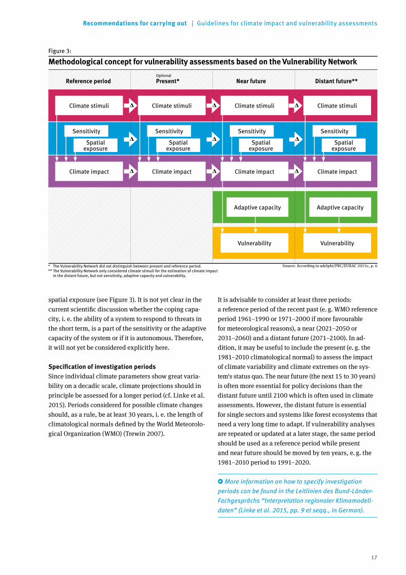
The initial IPCC concept of vulnerability did not establish a time reference. However, since this is essential for implementing the concept, the Vulnera-bility Network defined the elements of vulnerability as follows (also see Figure 3):
Climate stimuli* are described by the climate variab-les relevant for a climate impact such as temperature, precipitation, wind etc. There is a distinction between climate in the reference period (t0) and possible future climates (t>0). The change between t0 and t>0 describes climate changes such as rising tempera-tures, changes in precipitation or changes in weather extremes.
Sensitivity describes the extent to which a system (e. g. industrial sector, population group or ecosys-tem) reacts to climate stimuli. This is influenced by the spatial exposure of potentially affected systems** as well as socio-economic, biophysical and other factors. Distinction should be made between the climate sensitivity of the system “human – environ-ment” in the reference period and the changed sensi-tivity of a future system against a future climate.
A climate impact describes in period t0 the (potential) impact of the climate in the reference period on the system in the reference period taking into account the corresponding sensitivity. At time t>0, it describes the potential impact of the future climate on a future system taking into account the future sensitivity. The potential impact of climate change and other processes of change can be seen from the delta of climate impacts between t0 and t>0.
Adaptive capacity is the ability of a system to adapt to climate change in future and to reduce future potential damage. It includes avoidance, mitigation or protection measures that go beyond those which already exist. Adaptation measures taken in the past such as the establishment of an irrigation system to protect against climatic drought are not part of adaptive capacity but are included in the evaluation of sensitivity.
Vulnerability results from the climate impact on a system and its adaptive capacity. The Vulnerability Network only considered the vulnerability for individual sectors: their vulnerability results from their degree of threat by various climate impacts reduced by sectoral adaptive capacity. Vulnerability, like adaptive capacity, can only be determined for the future.
* In the context of the Vulnerability Network analyses and also in the final report (adelphi/PRC/EURAC 2015a), the term “climate signal” was used for climate stimuli. It is advisable not to use this term in this context in future because it has a different meaning in climatological usage.
** Spatial exposure was part of sensitivity within the scope of the Vulnerability Network analysis. Taking into account the changes in the IPCC report 2014, the guidelines identify it as an independent element of vulnerability (see Figure 2 and Annex 1).
3.1.2 Specifying the methodological framework and key terms
The concept of vulnerability and the key terms must be specified at the beginning of a vulnerability assessment. This will ensure that they are applicable to the issues in the assessment and the participants share a common understanding. The definitions of the terms of the Vulnerability Network (see example) can be used here.
The Vulnerability Network has developed an approach that allows clear conclusions with regard to time. It is particularly important in this context that time and space of the sensitivity and climate impact be assigned consistently with the time and area of the assessment. Adaptive capacity and thus vulnerability can only be investigated for the future. If the approach of the network, which is based on IPCC 2007, is transferred to the further development of the vulnerability concept described above, adaptive capacity has to be investi-gated separately for single future periods of time. In addi tion, a distinction is made between sensitivity and
17
Recommendations for carrying out | Guidelines for climate impact and vulnerability assessments
spatial exposure (see Figure 3). It is not yet clear in the current scientific discussion whether the coping capa-city, i. e. the ability of a system to respond to threats in the short term, is a part of the sensitivity or the adaptive capacity of the system or if it is autonomous. Therefore, it will not yet be considered explicitly here.
SpecificationofinvestigationperiodsSince individual climate parameters show great varia-bility on a decadic scale, climate projections should in principle be assessed for a longer period (cf. Linke et al. 2015). Periods considered for possible climate changes should, as a rule, be at least 30 years, i. e. the length of climatological normals defined by the World Meteorolo-gical Organization (WMO) (Trewin 2007).
It is advisable to consider at least three periods: a reference period of the recent past (e. g. WMO reference period 1961–1990 or 1971–2000 if more favourable for meteorological reasons), a near (2021–2050 or 2031–2060) and a distant future (2071–2100). In ad-dition, it may be useful to include the present (e. g. the 1981–2010 climatological normal) to assess the impact of climate variability and climate extremes on the sys-tem‘s status quo. The near future (the next 15 to 30 years) is often more essential for policy decisions than the distant future until 2100 which is often used in climate assessments. However, the distant future is essential for single sectors and systems like forest ecosystems that need a very long time to adapt. If vulnerability analyses are repeated or updated at a later stage, the same period should be used as a reference period while present and near future should be moved by ten years, e. g. the 1981–2010 period to 1991–2020.
More information on how to specify investigation periods can be found in the Leitlinien des Bund-Länder- Fachgesprächs “Interpretation regionaler Klimamodell-daten” (Linke et al. 2015, pp. 9 et seqq., in German).
Reference period Near future Distant future**
Climate stimuli Climate stimuli Climate stimuli Climate stimuli
Climate impact Climate impact Climate impact Climate impact
Vulnerability Vulnerability
Present*Optional
Spatial exposure
Spatial exposure
Spatial exposure
Spatial exposure
Sensitivity Sensitivity Sensitivity Sensitivity
Adaptive capacity Adaptive capacity
Figure 3:
* The Vulnerability Network did not distinguish between present and reference period.** The Vulnerability Network only considered climate stimuli for the estimation of climate impact in the distant future, but not sensitivity, adaptive capacity and vulnerability.
Methodological concept for vulnerability assessments based on the Vulnerability Network
Source: According to adelphi/PRC/EURAC 2015c, p. 6

18
Guidelines for climate impact and vulnerability assessments | Recommendations for carrying out
Instead of a future-oriented vulnerability assessment, one can also focus on the existing climate variability and the resulting hazard and compare it to the current coping capacity. For this purpose, it should be clarified beforehand what coping capacity, present sensitivity and future effective adaptive capacity cover to make this approach compatible with the approach presented here.
Specifying the area of investigation and spatial resolutionThe area investigated depends on the purpose and ob-jective of the investigation. Spatial resolution of the as-sessment also depends on this, but it is also influenced by available data, in particular climate and socio-econo-mic scenarios (see Section 3.1.3). Grids, natural areas or administrative units usually serve as spatial resolution.
3.1.3 Specifying scenarios for climate stimuli, spatial exposure and sensitivity
Determination of climate stimuli, spatial exposure and sensitivity requires climate and possibly biophysical and socio-economic data for the periods of investi-gation. Comparing the reference period to present or future can then show potential changes. Measured data from past and present are often available. However, the description of future climate stimuli, spatial expo-sure and sensitivities should be based on scenarios or projections, provided that they are available or can be determined. Priority should be given to those climate, spatial or sensitivity parameters that are relevant to the observed or projected climate impacts.
Climate projectionsFuture climate is usually investigated by a model chain comprising first an emission or concentration scenario, second a global climate model and third at least one regional climate model. Currently, the generally acknowl-edged state of the art is to work with what is referred to as an ensemble of climate projections. They are based on different combinations of global and regional climate models and help describe the range of uncertainties in the anticipated climate changes.
KEY RECOMMENDATIONS: Planning climate impact or vulnerability assessments
1. The purpose of climate impact or vulnerability assessment must be taken into account when designing and selecting the methods because the desired result and possible evaluation schemes depend on it.
2. There are several concepts of vulnerability. When starting a climate impact or vulnerability assess-ment, it must be decided which concept to follow. It is recommended to use the further developed con-cept of vulnerability for the time being (see Figure 2).
3. At the beginning of the assessment the key terms climate stimuli, sensitivity, spatial exposure, climate impact, adaptive capacity and vulnerability must be defined as unambiguously as possible to be able to apply them for empiric research. Based on the definitions of the Vulnerability Network, it is recom-mended to ensure consistent time and spatial points of reference. Climate stimuli should primarily be operationalised using climate parameters while
sensitivity should map non-climate variables, including socio-economic factors. Spatial exposure indicates the presence of systems that are affected by climate stimuli. Adaptive capacity should be estimated in terms of its time-related effectiveness and clearly distinguished from sensitivity.
4. Finally, the area of investigation, spatial resolution and the periods of investigation should be specified with a view to the aim of assessment. The 1961–1990 or 1971–2000 reference period is recommended. An outlook for the near future (i.e. 2021–2050 or 2031–2060) is appropriate for policy recommendations. The distant future (2071–2100) should also be included for long-term developments and planning. Optionally, present (1981–2010) can be considered.

19
Recommendations for carrying out | Guidelines for climate impact and vulnerability assessments
More information about the use of ensembles for climate projections can be found in the Leitlinien des Bund-Länder-Fachgesprächs “Interpretation regionaler Klimamodelldaten” (Linke et al. 2015, p. 12 et seqq. in German).
Before a decision is taken, it should be checked what conditions the climate projections must satisfy to meet the requirements of the selected climate parameters and climate impact models. Time series e. g. for hydrological modelling that include consistent parameters such as daily temperature and precipitation values are neces-sary. However, they are not easy to provide because of bias minimisation11 often needed for climate projections and the ensemble approach. In any case, the model en-semble should cover the entire area of investigation and consist of a sufficient number of model runs in order to assess climate variability and be based on a previously specified emission or concentration scenario.
11 Systematic deviations of the individual climate models from observed data about the recent climate are referred to as “bias”. Bias minimisation means the adaptation of the simulated data set to the observed data which is aimed at reducing deviation. See Linke et al. 2015, p. 24.
If ensemble approaches are insufficient for the object of investigation, at least two different climate projections should be used to represent a range of future alternati-ves. If data from other climate projections are available for certain climate impacts, they should be classified into the existing ensemble for better comparability.
EXAMPLE: Climate projections used in the Vulnerability Network
A climate projection ensemble with 17 ensemble members was used for the analysis of the Vulner-ability Network. The ensemble was based on the emission scenario A1B of the Special Report on Emis-sions Scenarios (SRES, Intergovernmental Panel on Climate Change 2000, for further explanations see www.dwd.de/klimaatlas). Climate projections usually provide daily values. With the exception of wind data, the German Meteorological Service regionalised climate projections using a uniform spatial grid with a 5-by-5-kilometre resolution and performed bias minimisation. Imbery et al. (2013) describe the methods used. Assessments of extreme wind speeds are available in a 25-by-25-kilometre spatial resolu-tion.Percentile values were given in order to illustrate the range of model results. The percentiles can be interpreted as follows (German Federal Government 2011):
▸ 15th percentile: 85 percent of projections project higher, and 15 percent project the displayed or lower rates of change (usually referred to as weak change in the project context).
▸ 85th percentile: 85 percent of the ensemble project the displayed or lower rates of change, and 15 percent project higher rates of change (usually referred to as strong change in the project context).
The range between the selected lower and upper bounds thus comprises a 70-percent probability of occurrence with respect to the ensemble considered. (Note: The terms “probability” and “quantile” used here are based solely on the climate projection ensemble used. This ensemble represents only a part of potential future climate options so that the presented results are not statistical probabilities of occurrence in a narrower sense.)Some climate data from the Potsdam Institute for Climate Impact Research (PIK) were applied. In these cases, the 95th percentile was used for a strong change and the 5th percentile for a weak change. (For details see adelphi/PRC/EURAC 2015a.) Where existing model results were used, deviating climate projections were also included. Care was taken that the assumptions of model calculations were similar to those of the project. A wet and a dry scenario were generally calculated for precipitation-driven models.

20
Guidelines for climate impact and vulnerability assessments | Recommendations for carrying out
ReKliEs – research project on regional climate projections In the ReKliEs-De project (Regional Climate Projections Ensemble for Germany), the IPCC concentration scenarios are currently being systematically evaluated for Germany (including catchment areas draining toward Germany) and completed by selected additional simula-tions (using both dynamic and statistical methods). The aim of the project is to provide reliable information on the ranges and extremes of future climate develop-ment in Germany. Other project objectives are the estimation of the necessary minimum ensemble size to generate reliable conclusions and investigate systematic differences between the results of statistical and dynamic regional climate models. http://reklies.hlnug.de/startseite.html (in German)
Sensitivity scenarios and scenarios for spatial exposureSensitivity and spatial exposure also should, where possible, be based on scenarios that are consistent with climate projections in terms of time. Some of the socio-economic or biophysical parameters such as population or tree species composition can be quan-titatively projected for near future (up to 2030). Since spatial exposure is closely linked to the development of (socio-economic) sensitivity, joint sensitivity and spatial scenarios should be developed. Existing uncertainties can be taken into account by using at least two sensiti-vity and spatial scenarios. Spatial exposure was part of sensitivity in the vulnerability assessment of the Vulnerability Network. Moreover, most sensitivities
EXAMPLE: Sensitivity scenarios used in the Vulnerability Network
The Vulnerability Network specified two different development paths with a growth and a stagnation scenario for near future, which – like climate projec-tions – covered the range of possible developments also with regard to socio-economic development. Two scenarios of the PANTA RHEI REGIO model provided the basics. PANTA RHEI REGIO models demographic developments and land use at a district level. The results were used to model land-use changes on a grid-cell basis with a resolution of one hectare using LAND USE SCANNER:
▸ For the growth scenario, the results of the subproject “Land Use Scenarios” of the CC-LandStraD project (Federal Institute for Research on Building, Urban Affairs and Spatial Development 2012) were avail-able for 2030 and were used by the Vulnerability Network. CC-LandStraD was funded by the German Federal Ministry of Education and Research (BMBF).
▸ For the stagnation scenario, the 2030 projections were recalculated by the Federal Institute for Research on Building, Urban Affairs and Spatial Development (based on Federal Ministry of Trans-port, Building and Urban Development 2011 and Distelkamp et al. 2011).
Table 2:
Parameters and statistical values of socio-economic development for land use scenarios (2009 to 2030)
Parameter Growth scenario Stagnation scenario
Annual external migration balance(long-term, projected target figures)
+150.000 +70.000
Annual gross domestic product(long-term, projected target figures)
+1.1 percent average per year +0.58 percent average per year
Population development 2009 to 2030
-3.92 percent (-0.19 percent average per year)
-7.56 percent (-0.37 percent average per year)
Absolute population 2030 78,68 million 75,67 million
Absolute number of households 2030
41,3 million 40,3 million
Daily land take 2009 to 2030 (nationwide, conversion of unde-veloped into developed areas)
59.0 hectares average per year 49.3 hectares average per year
Source: adelphi/PRC/EURAC 2015a, p. 98
21
Recommendations for carrying out | Guidelines for climate impact and vulnerability assessments
which change over time are of socio-economic charac-ter. The Vulnerability Network thus only considered socio-economic sensitivity scenarios.
The Vulnerability Network primarily used forecasts or projections for population development and land use in near future (see example). Projections for distant future and other socio-economic parameters were often lacking; these should, however, be developed in future.
Scenario combinations Climate projections and scenarios for sensitivity and spatial exposure must be combined for the assessment of climate impacts.
Scenario combinations should be used to show the range of possible developments of climate impacts. These should cover the spectrum of the combination of
a strong climate change with a strong socio-economic development as well as a weak climate change with a weak socio-economic development. However, it should be mentioned that strong (local) socio-economic change is not necessarily linked to a strong (global) climate
change. It is therefore worth considering cross-com-bining socio-economic and climate scenarios (strong- weak and vice versa), in order, for example, to identify whether climate impacts are driven more by climate or socio-economic change.
EXAMPLE: Combining scenarios in the Vulnerability Network
The Vulnerability Network investigated two scenario combinations for the near future to assess the range of future climate and socio-economic developments:
▸ Strong change: The 85th percentile of the German Weather Service (DWD) climate model ensemble results (which is based on the SRES-A1B emissions scenario) was generally used for climate projections. This was combined with the scenario of relatively strong socio-economic development, including an average annual economic growth of 1.1 percent, an average daily land take of 59 hectares, and a popu-lation decline to 78.68 million inhabitants by 2030.
▸ Weak change: The 15th percentile of the DWD cli-mate model ensemble results was generally used for climate projections. Compared to the strong change scenario, the socio-economic scenario used for this combination is based on a lower annual economic growth (0.58 percent on average), a lower daily land take (49.3 hectares), and a stronger decrease in population to 75.67 million by 2030.
There are no socio-economic scenarios for the distant future (2071–2100) due to lack of data, which means that no scenario combinations could be created. Therefore, the estimation of climate impacts for the distant future was based on qualitative expert projec-tions in combination with climate model results (15th and 85th percentile from the climate model ensemble of the DWD). These expert projections were integrated into the consolidated qualitative evalua-tions using verbal description for climate impacts in the distant future. For details see the Vulnerability Network’s final report (adelphi/PRC/EURAC 2015a) (in German).

22
Guidelines for climate impact and vulnerability assessments | Recommendations for carrying out
3.2 Working step 2: Step-by-step execution of the climate impact and vulnerability assessment
3.2.1 Developing impact chains
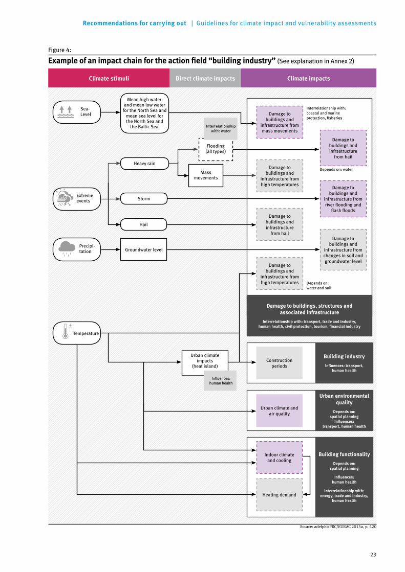
In order to assess the cause-effect interlinkage between climate stimuli and possible climate impacts, it is recommended to create so-called impact chains for each action field (see example in Figure 4 as well as the exemplary explanation of cause-effect interlinkages in an impact chain in Annex 2, see Section 6.2).12 Impact chains help understand, systematise and prioritise which factors influence the impacts of climate extremes and climate change on a system. Both direct climate impacts on biophysical and socio-economic (sectoral) systems and indirect climate impacts can be considered. For example, direct biophysical impacts include the development of floods as a result of heavy precipitation in certain catchment areas. Socio-economic impacts include for instance heat stress on human health. Indi-rect climate impacts include the impacts of changes in flood frequencies on sensitive systems such as humans or material goods. The impact chains clarify which climate parameters influence which possible climate
12 Impact chains for 13 further action fields of the German Adaptation Strategy are presented for the national level at www.umweltbundesamt.de/sites/default/files/ medien/380/dokumente/klimawirkungsketten_umweltbundesamt_2016.pdf (in German).
impacts and therefore provide the basic framework for the vulnerability assessment. In addition, they serve as an important communication tool that helps stake-holders involved agree on what needs to be assessed and which climate and socio-economic or biophysical parameters play a role. This makes it easier to derive targeted adaptation measures following the vulnera-bility assessment.
It is therefore recommended to also include the most important factors that influence the system’s sensitivity to climate change in the impact chains, especially in simple impact chains. In this way impact chains can re present the complete assessment framework for the consideration of climate impacts. In the case of very com plex systems which can be affected by many different climate impacts, the integration of the sensitivity can reduce the clarity and manageability of the impact chains.
Impact chains can also help assess the interrelations-hips between the different action fields. For example, the graphic representation can depict such interlinkages through different colours assigned to each action field. This provides a clear visualisation of when similar climate impacts are important for several action fields, or when a climate impact in one action field triggers a climate impact in another action field. This is highly significant for cross-sectoral assessments.
KEY RECOMMENDATIONS: Scenarios for climate stimuli, spatial exposure and sensitivity
1. If possible, an ensemble of climate projections should be used to determine the climate stimuli. The 15th and 85th percentile of a model ensemble can be used to provide a statistically significant range of possible developments (see Linke et al. 2015).
2. An emission or concentration scenario must be chosen to be used in addition to a model ensemble. In order to use the broadest possible ensemble of climate projections, it is recommended to choose an emission or concentration scenario with many global and regional model runs. The SRES Emissions Scenario A1B has so far been a widespread medium scenario. New concentration scenarios – known as “representative concentra-tion pathways” (RCPs) – were published in the fifth IPCC Assessment Report. In future, it appears to
make sense to use RCP 8.5 and 2.6, where RCP 8.5 is a “business-as-usual” scenario, while RCP 2.6 is a political scenario that corresponds to the 2°C target.
3. It is not only the climate that changes, but also the systems it impacts. Therefore, scenarios should additionally be used to consider future spatial exposure and future sensitivity. These should be temporally and spatially consistent with the climate projections.
4. Climate projections and sensitivity/spatial scenar-ios should be combined. It is recommended to consider at least two alternative scenario combina-tions (strong and weak change) if possible since this enables the assessment of the range of possible developments.
23
Recommendations for carrying out | Guidelines for climate impact and vulnerability assessments
Direct climate impactsClimate stimuli Climate impacts
Storm
Precipi- tation
Mean high water and mean low water
for the North Sea and mean sea level for the North Sea and
the Baltic Sea
Sea- Level
Temperature
Flooding (all types)
Mass movements
Groundwater level
Urban climate impacts
(heat island)
Hail
Influences: human health
Interrelationship with: water
Interrelationship with: coastal and marine protection, fisheries
Damage to buildings and
infrastructure from mass movements
Damage to buildings and infrastructure
from hail
Damage to buildings and
infrastructure from high temperatures
Damage to buildings and infrastructure
from hail
Damage to buildings and
infrastructure from river flooding and
flash floods
Damage to buildings and
infrastructure from changes in soil and groundwater level
Heavy rainDepends on: water
Building industry
Influences:transport, human health
Urban environmental quality
Depends on: spatial planning Influences:
transport, human health
Building functionality
Depends on: spatial planning
Influences: human health
Interrelationship with: energy, trade and industry,
human health
Urban climate and air quality
Construction periods
Indoor climate and cooling
Heating demand
Damage to buildings, structures and associated infrastructure
Interrelationship with: transport, trade and industry, humanhealth,civilprotection,tourism,financialindustry
Depends on: water and soil
Extreme events
Damage to buildings and
infrastructure from high temperatures
Figure 4:
Exampleofanimpactchainfortheactionfield“buildingindustry”(See explanation in Annex 2)
Source: adelphi/PRC/EURAC 2015a, p. 420
24
Guidelines for climate impact and vulnerability assessments | Recommendations for carrying out
Selecting climate impactsIt is recommended to first develop simple impact chains for all climate impacts at the working level, together with the involved experts from responsible institutions. These should be based on existing (literature) know-ledge. This should be done regardless whether these impacts can be represented with models, indicators or expert knowledge. If more possible climate change impacts were identified than can be investigated within the framework of the assessment, the decision-making level needs to subsequently select the climate impacts that appear particularly relevant for the respective assessment and its purpose. The advantage of this approach is that technical and regional or local condi-tions can be taken into consideration, which ultimately increases the acceptance of the assessment results. The more concrete the purpose has been defined, the more clearly the selection criteria can be identified.
3.2.2 Operationalising selected sectoral climate impacts
Operationalisation paths for climate impactsIn order to operationalise the selected climate impacts relevant indicators should be discussed in expert work-shops. In cooperation with the participating experts from responsible institutions, possibilities for operatio-nalising individual climate impacts should be identified and selected to create the basis for further evaluation steps. This is particularly recommended when experts from responsible institutions have a specific technical or spatial relation to the selected climate impacts and/or when they hold adequate data that is necessary for the operationalisation. However, the procedure of collecting indicators should be similar for the entire model area.
Furthermore, it is recommended to use clearly defined indicators for climate impacts. These can be quantitative (such as potential flooding areas as an indicator for the climate impact flooding), but also semi-quantitative or qualitative (for example, an estimation of energy availability). The selection of indicators should be pragmatic, as it is impossible for vulnerability assess-ments to accurately investigate all climate impacts and their interlinkages in detail. While a higher number of indicators would make the investigation broadly more detailed, it can also increase error susceptibility and lower transparency. Consequently, only those indicators should be selected that lead to a clear increase in infor-mation.
The procedure for the evaluation of climate impacts should follow the same methodology for both reference period (t0) and (near) future (t>0) if the results are to be compared. In addition to the conditions of the system at a given time, the change between the periods should also be considered. This is because the rate and speed at which the system conditions change between the reference period and the near future also enable initial estimations for the distant future. This is however only possible if no threshold values and tipping points are exceeded and nonlinear processes need not be taken into account. It is necessary to estimate the distant future in a simplified manner if it cannot be assessed due to the lack of qualitative and quantitative sensitivity or spatial scenarios.
KEY RECOMMENDATIONS: Developing impact chains
1. It is recommended to describe climate impacts by means of impact chains, which represent the interlinkages between climate stimuli, spatial exposure, sensitivity and climate impact. Impact chains can help select climate impacts as well as appropriate assessment and evaluation methods and assess interrelationships between sectors.
2. Working and decision-making levels should agree on the impact chains.
3. If necessary, those climate impacts should be selected that are of primary relevance for the investigation area. The selection criteria should be based on the aim of the assessment and may include the social, economic, ecological, cultural and territorial significance of climate impacts for the respective investigation area.

25
Recommendations for carrying out | Guidelines for climate impact and vulnerability assessments
There are three basic methodological approaches (operationalisation methods) for the assessment of future climate impacts:
1. Impact models If impact models are available that represent the complex and often nonlinear interlinkages between climate parameters and sensitivity parameters the results of these models should be applied. For exam-ple, the Vulnerability Network used a model for esti-mating the climate impact “soil water content” based on the Soil Information System of the Federal Institute for Geosciences and Natural Resources (FISBo BGR) to calculate the effective water balance of the main vegetation period. When using models it is important to check the underlying assumptions and to verify whether they are consistent with the basic assump-tions of the assessment regarding the time-related and spatial structures as well as the climate and socio-economic scenarios used.
2. Use of proxy indicators13 If there are no suitable impact models, climate impacts should be parameterised using plausible data. This should be based on proxy indicators specified by experts for the core elements climate stimuli, spatial exposure and sensitivity. This means that one or more climate parameters as well as parameters for spatial exposure and sensitivity are used and combined for each climate impact. The selection of the proxy indi - cators depends among others on the spatial resolution. For example, the Vulnerability Network’s assessment for the climate impact “effect on the sewer system and wastewater treatment plants” combined the proxy indicators heavy rain and degree of soil sealing. In order to combine the information on climate stimuli, spatial exposure and sensitivity and thereby harmonise the dimensions and scales of all parame-ters, it is recommended to normalise all values on a dimensionless scale of 0–1. If available, one can rely on agreed or technically justified thresholds for this purpose. Should there be none available, a so-called “min-max normalisation” can be applied. In this case, the smallest value across all periods considered is set to “0”, while the largest value is set to “1”. If climate impacts are normalised this way, it must be clearly communicated that they do not contain information
13 So-called proxy data is used to investigate a situation, a phenomenon or a condition for which there is no direct information (EEA 2015).
on the strength of the climate impact nor as to when a climate impact is critical. This type of normalisation does not necessarily imply that the extreme values of the scale indicate optimal or critical conditions. The next step combines the normalised values of climate parameters, indicators of spatial exposure and sensitivity for each spatial unit. The values were multiplied in the Vulnerability Network. In principle, however, other procedures are also possible (e. g. the geometric mean). This results in a climate impact scale of 0–1, which helps map the spatial and time- related patterns and changes. Normalisation is also important when different climate impacts are to be aggregated (see below) or combined with values for adaptive capacity into a vulnerability value.
3. Expert knowledge If causal relations cannot be fully or only partially quantified through the two approaches mentioned above, the strength of climate impacts can be evalua-ted using expert surveys. For example, the Vulner-ability Network applied this method for estimating the climate impact “management of dams”. The survey of relevant experts can be used to localise their knowledge about climate impacts in the inves-tigation area and to translate it into suitable scales (e. g. from one to five). Survey guidelines should be developed which separately address the elements of climate impact, spatial exposure and sensitivity and cover the investigation periods used.14 The aim should also be to involve a sufficiently large and representative number of experts with a suitable technical background.
These recommendations on operationalisation should help create a comprehensive, preferably quantitative conclusion on climate impacts and enable the compa-rison of different indicators. If the assessment pursues a different goal and aims for instance to identify single “hot spots” or detailed causal interlinkages, an alter-native approach can be used: In these cases it is appro-priate to first conduct expert surveys on all climate impacts but to quantify only those where more precise conclusions are needed. In particular at the local level, this procedure, which is predominantly based on expert surveys, can be more effective.
14 An example for such survey guidelines can be found in the Annex of the Vulnerability Network’s final report (adelphi/PRC/EURAC 2015b, p. 17 et seqq., in German).

26
Guidelines for climate impact and vulnerability assessments | Recommendations for carrying out
Verifying data availabilityData is the central issue of many quantitative assess-ments. Their availability or non-availability can be a limiting factor. Therefore, the following points should be considered:
▸ Nation- or state-wide data are necessary if the aim is to obtain comparable results for different climate impacts for the whole investigation area.
▸ For spatially specific results, data should be available at a uniform reference level (for example, districts) or able to be aggregated accordingly. Grid data (for example, climate data) can be applied to adminis-trative spatial units. Vice versa, data for spatial units can also be converted into grid data.
▸ The data should be available at least for the reference period and the near future and ideally for the present and the distant future, should these be considered.
▸ If data gaps are identified at an early stage, it can be decided whether climate impacts can be quantified or should be estimated using qualitative surveys.
▸ The effort of the investigation work for the measure-ment of climate impacts depends more on the choice of indicators than on the chosen operationalisation method. Both the assessment in itself and interpre-ting the results are time-consuming.
EstimatingthelevelofconfidenceBoth calculated results and those obtained from expert surveys are subject to uncertainties. It is recommended to estimate the confidence of the results of the climate impacts in order to facilitate the interpretation of the results. This should be done separately for the calcula-ted climate impacts (operationalised via models or proxy indicators) and climate impacts operationalised via surveys. Sources for the uncertainty of calculated climate impacts can be found in the models and scena-rios used, the data and the specification of the selected indicators themselves. The confidence of the survey results can be obtained from the level of certainty of the experts in their opinions and the consensus between the experts – similar to the “confidence scale” concept of the Intergovernmental Panel on Climate Change (Mastrandrea et al. 2010).
EXAMPLE: Factsheets for Vulnerability Network indicators
The Vulnerability Network has compiled factsheets for the indicators used. Each factsheet contains a description of the indicator, including their sources. See Annex 7 of the final report for a list of indicators (adelphi/PRC/EURAC 2015b, pp. 47–152, in German).
The annex is available at: www.umweltbundesamt.de/sites/default/files/medien/378/publikationen/ climate_change_24_2015_anhang_vulnerabilitaet_deutschlands_gegenueber_dem_klimawandel_1.pdf

27
Recommendations for carrying out | Guidelines for climate impact and vulnerability assessments
EXAMPLE: AssessingthelevelofconfidenceforsurveyresultsintheVulnerabilityNetwork
The experts were asked to estimate how certain they were in their statements about a climate impact. Their data were subsequently averaged. Thus, when one expert confirmed he was certain while yet another expert was uncertain, the value ‘medium’ was obtained for the experts’ certainty. If this was not possible, the next worst value was adopted. The value of the experts’ consensus is based on the following two criteria: 1. Are the experts’ evaluations no more than one
stage apart on the rating scale?2. Is the tendency of the changes from t0 to t1
(weak change) and from t1 (weak change) to t1 (strong change) the same?
If both criteria apply, the consensus is high. If only one applies, the consensus is medium; if none of the criteria holds, it is low.Thus the level of confidence for the expert surveys can be given in five steps according to the following scheme (Table 3).
Accordingly, it is recommended to evaluate the level of confidence for each indicator and each climate impact at least on a scale ranging from “low” to “medium” to “high”, or better still on a five-stage scale. A verbal conclusion should be drawn for climate impacts which
have been investigated using several indicators. Since the confidence assessment is in part subjective, it should be performed by the experts involved and experts from responsible institutions according to their technical competence.
KEY RECOMMENDATIONS: Operationalising climate impacts
1. Clearly defined indicators are recommended to describe climate impacts. The indicators can be quantitative, semi-quantitative or qualitative.
4. Climate impacts should be assessed using the same methodology for the reference period, the present and the (near) future to produce
2. For the operationalisation of selected climate impacts, relevant indicators and operationalisation options should be identified and specified together with participating experts from responsible institutions.
3. Depending on the objective of the assessment, quantitative or qualitative methods can be used. Quantitative methods such as impact models and proxy indicators are objectively traceable and enable spatially detailed results. Qualitative methods, on the other hand, are independent of data availability and summarise knowledge and experience of the surveyed experts.
comparable results.5. It is recommended to request data from relevant
authorities or research institutes at an early stage since time (and personnel) expenditure required to compile the requested data is sometimes very high.
6. It is recommended to estimate the confidence of the results for climate impacts in order to facilitate interpretation.
Consensusof experts
3 4 5
2 3 4
1 2 3
Certainty of experts
Table 3:
Levelofconfidenceassessmentscheme
Source: adelphi/PRC/EURAC 2015a, p. 59
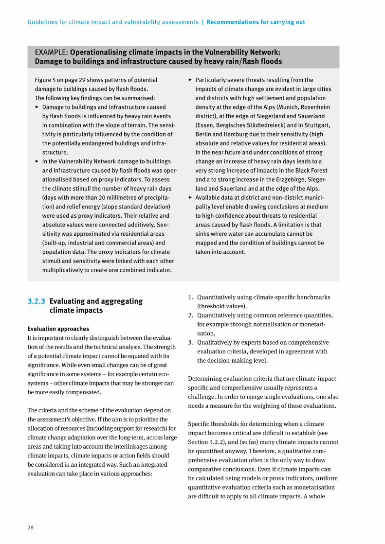
28
Guidelines for climate impact and vulnerability assessments | Recommendations for carrying out
3.2.3 Evaluating and aggregating climate impacts
Evaluation approachesIt is important to clearly distinguish between the evalua-tion of the results and the technical analysis. The strength of a potential climate impact cannot be equated with its significance. While even small changes can be of great significance in some systems – for example certain eco-systems – other climate impacts that may be stronger can be more easily compensated.
The criteria and the scheme of the evaluation depend on the assessment’s objective. If the aim is to prioritise the allocation of resources (including support for research) for climate change adaptation over the long-term, across large areas and taking into account the interlinkages among climate impacts, climate impacts or action fields should be considered in an integrated way. Such an integrated evaluation can take place in various approaches:
1. Quantitatively using climate-specific benchmarks (threshold values),
2. Quantitatively using common reference quantities, for example through normalisation or monetari-sation,
3. Qualitatively by experts based on comprehensive evaluation criteria, developed in agreement with the decision-making level.
Determining evaluation criteria that are climate-impact specific and comprehensive usually represents a challenge. In order to merge single evaluations, one also needs a measure for the weighting of these evaluations.
Specific thresholds for determining when a climate impact becomes critical are difficult to establish (see Section 3.2.2), and (so far) many climate impacts cannot be quantified anyway. Therefore, a qualitative com-prehensive evaluation often is the only way to draw comparative conclusions. Even if climate impacts can be calculated using models or proxy indicators, uniform quantitative evaluation criteria such as monetarisation are difficult to apply to all climate impacts. A whole
EXAMPLE: Operationalising climate impacts in the Vulnerability Network: Damagetobuildingsandinfrastructurecausedbyheavyrain/flashfloods
Figure 5 on page 29 shows patterns of potential damage to buildings caused by flash floods. The following key findings can be summarised:
▸ Damage to buildings and infrastructure caused by flash floods is influenced by heavy rain events in combination with the slope of terrain. The sensi-tivity is particularly influenced by the condition of the potentially endangered buildings and infra-structure.
▸ In the Vulnerability Network damage to buildings and infrastructure caused by flash floods was oper-ationalised based on proxy indicators. To assess the climate stimuli the number of heavy rain days (days with more than 20 millimetres of precipita-tion) and relief energy (slope standard deviation) were used as proxy indicators. Their relative and absolute values were connected additively. Sen-sitivity was approximated via residential areas (built-up, industrial and commercial areas) and population data. The proxy indicators for climate stimuli and sensitivity were linked with each other multiplicatively to create one combined indicator.
▸ Particularly severe threats resulting from the impacts of climate change are evident in large cities and districts with high settlement and population density at the edge of the Alps (Munich, Rosenheim district), at the edge of Siegerland and Sauerland (Essen, Bergisches Städtedreieck) and in Stuttgart, Berlin and Hamburg due to their sensitivity (high absolute and relative values for residential areas). In the near future and under conditions of strong change an increase of heavy rain days leads to a very strong increase of impacts in the Black Forest and a to strong increase in the Erzgebirge, Sieger-land and Sauerland and at the edge of the Alps.
▸ Available data at district and non-district munici-pality level enable drawing conclusions at medium to high confidence about threats to residential areas caused by flash floods. A limitation is that sinks where water can accumulate cannot be mapped and the condition of buildings cannot be taken into account.

29
Recommendations for carrying out | Guidelines for climate impact and vulnerability assessments
EXAMPLE (Continued from page 28): Operationalising climate impacts in the Vulnerability Network
Mapsforthe“Potentialdamagetobuildingscausedbyflashfloods”indicator
Reference
Weak change
Strong change
Legend
Clim
ate
impa
ctD
irect
clim
ate
impa
ct
Present
Sens
itiv
ity
Weakest climate impact
Strongest climate impact
Weakest climate stimuli/Direct climate impact
Strongest climate stimuli/Direct climate impact
Weakest sensitivity
Strongest sensitivity
Strongest increase
Strongest decrease
No change
Near future
Present Near future
Present Near future
Flashfloodpotential
Residential areas and population density
Level of confidence Low Medium High
Source: adelphi/PRC/EURAC 2015a, p. 430
Figure 5:

30
Guidelines for climate impact and vulnerability assessments | Recommendations for carrying out
EXAMPLE: Comparative evaluation of climate impacts in the Vulnerability Network
Federal authorities and institutions participating in the Vulnerability Network have evaluated the signi-ficance of investigated climate impacts for Germany. The evaluation was carried out for the present and the near future in cases of weak and strong change.The network partners evaluated this significance on a scale ranging from “low” to “medium” to “high” in a structured survey. The network partners’ evalua-tion considered several criteria simultaneously:
social, economic, ecological and cultural as well as the territorial significance of climate impacts. The scientific consortium evaluated the significance of all climate impacts for Germany in a first step to provide an orientation to the network partners. However, this evaluation by the consortium was not included in the final overall evaluation. The overall evaluation was made by calculating the average from the individual evaluations by the network partners.
series of normative assumptions are for instance needed in order to monetarise climate impacts on natural areas and ecosystems, for example spread of invasive species.
Table 4:
TemplatetoevaluatethesignificanceofclimateimpactsforGermany(actionfield“soil”)
Climate impact
Significance of climate impact for Germany
PresentNear future
Weak change Strong change
ConsortiumNetwork partner
ConsortiumNetwork partner
ConsortiumNetwork partner
Soil
Soil erosion by water and wind, landslide
Low Low Medium
Soil water content, leachate
Low Low Medium
Production functions (site stability, soil fertility)
Low Low Medium
Soil biodiversity, microbial activity
Medium Medium Medium
Soil organic matter, nitrogen and phosphorus budget, substance discharges
Medium Medium Medium
Source: adelphi/PRC/EURAC 2015a, p. 60
Template used by network partners to make their own evaluations

31
Recommendations for carrying out | Guidelines for climate impact and vulnerability assessments
AggregationAggregating the results of individual climate impacts is a useful way to draw cross-sectoral and summary conclusions. However, such an aggregation is only possible if the units of the data sets are compatible or if the data are dimensionless, which can be achieved e. g. by normalisation as described in Section 3.2.2. In order to be able to aggregate or blend the data in a spatially differentiated way, they must as a rule have a similar resolution and be available for the entire area.
Even if these criteria are met, a summary of climate impacts can only represent a part of the overall possible climate impact. Aggregations always require simplified decisions, for example, as to what climate impacts are involved and how they are weighted. Thus, an aggre-gation is based on normative decisions and must be presented transparently. In practice, the question arises in particular in the case of more complex and cross- sectoral analyses as to what extent such aggregations are feasible and justifiable and how the necessary deci-sions are made. If these questions cannot be answered adequately, a qualitative, interpretative summary of the individual results should be preferred – since also deciding to weight all climate impacts equally would be arbitrary and would have to be justified normatively.
To ensure transparency of the results, an incremental aggregation from the small to the large should be preferred in every case. Each aggregation causes an information loss which must be recognisable and traceable for the target audience. Thus, the climate impacts for individual action fields should be first aggregated based on the impact chains before they are blended cross-sectorally.
If quantitative results about the strength of climate impacts are available which have the same spatial refer-ence, averaging can be used to aggregate them. In this case, the results can be evaluated uniformly to weight the climate impacts. The Vulnerability Network assess-ment did not aggregate the (relative) strength values of the climate impact but rather their (dimensionless, non-area-specific) significance. This enabled the aggre-gation of climate impacts which had in various ways been quantitatively or qualitatively operationalised. The degree of threat was estimated for each action field (see Section 3.2.5). It is important in this procedure that the scaling level of the rating scale allows averaging.
Climate impact assessments end at this point and go over directly to Step 3 – Communicating results (see Section 3.3). The following steps (Section 3.2.4 and 3.2.5) are only relevant for vulnerability assessments.
KEY RECOMMENDATIONS: Evaluating and aggregating climate impacts
1. It is recommended that the significance of indivi-dual climate impacts be quantitatively evaluated if appropriate thresholds are available or if climate impacts can be converted into common reference values. If this is not possible, a semi-quantitative or qualitative evaluation involving experts is recom-mended.
2. It is important to clearly distinguish between technical results and their normative evaluation. Aggregation should be performed gradually. Climate impacts should first be aggregated for single action before they are blended together.
3. Since the quantitative aggregation of single results is methodologically rather complex, it should instead be considered to qualitatively combine them or to aggregate the evaluations of the single climate impacts.
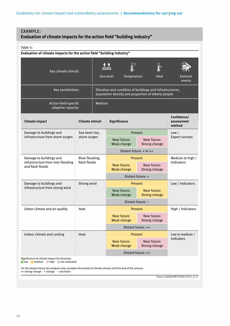
32
Guidelines for climate impact and vulnerability assessments | Recommendations for carrying out
EXAMPLE: Evaluationofclimateimpactsfortheactionfield“buildingindustry”
Table 5:
Significance of climate impact for Germany: low medium high not evaluated
For the distant future the analysis only considers the trends of climate stimuli until the end of the century:++ strong change + change ~ uncertain
Evaluationofclimateimpactsfortheactionfield“buildingindustry”
Source: adelphi/PRC/EURAC 2015c, p. 37
Key climate stimuli:Sea-level Temperature Heat Extreme
events
Key sensitivities: Situation and condition of buildings and infrastructures, population density and proportion of elderly people
Action-field-specific adaptive capacity:
Medium
Climate impact Climate stimuli SignificanceConfidence/ assessment method
Damage to buildings and infrastructure from storm surges
Sea-level rise, storm surges
Present Low / Expert surveys
Near future: Weak change
Near future: Strong change
Distant future: + to ++
Damage to buildings and infrastructure from river flooding and flash floods
River flooding, flash floods
Present Medium to high / Indicators
Near future: Weak change
Near future: Strong change
Distant future: +
Damage to buildings and infrastructure from strong wind
Strong wind Present Low / Indicators
Near future: Weak change
Near future: Strong change
Distant future: ~
Urban climate and air quality Heat Present High / Indicators
Near future: Weak change
Near future: Strong change
Distant future: ++
Indoor climate and cooling Heat Present Low to medium /Indicators
Near future: Weak change
Near future: Strong change
Distant future: ++

33
Recommendations for carrying out | Guidelines for climate impact and vulnerability assessments
3.2.4 Evaluating adaptive capacity
In addition to climate impacts, the adaptive capacity must also be evaluated in order to carry out a complete vulnerability assessment. For practical reasons, it is recommended to integrate the adaptive capacity as a status quo, i.e. its current condition, in the vulnerability assessment. Adaptive capacity thus represents the currently identifiable scope of options for adapting to the expected climate change by means of additional measures. It is therefore not necessary to develop specific scenarios or to consider ways in which adaptive capacity could potentially change in future.
Nevertheless, the evaluation of adaptive capacity is par- ticularly challenging in a vulnerability assessment. On the one hand, it comprises technical and financial possibilities for adapting to climate change and reacting to extreme events, i.e. the presence of different resources such as infrastructure, know-how or income. On the other hand, a large number of other societal factors influence adaptive capacity – and these are sometimes difficult to measure. They interact with one another and include, for example, awareness that adaptation is necessary, social capital and governance structures. In order to take such factors into account, it is recommended to study three types of adaptive capacity separately: action-field-independent, action-field-specific and climate-impact-specific adaptive capacity. These three adaptive capacities enable different conclusions about the vulnerability of a region in general, of an action field or to a single climate impact, and thus offer differentiated estimations of the needs for action.
The action-field-independent, generic adaptive capacity of a region can generally be determined quantitatively using indicators on social, administrative and econo-mic issues. This data should be spatially differentiated in order to compare the adaptive capacities of different subspaces. In addition, the adaptive capacities resulting from the cross-sectional topics “spatial planning” and “civil protection” identified in the German Adaptation Strategy can also be included and perhaps supplemen-ted by “financial services industry” (insurance and lending). They play an important role in precaution and disaster recovery. In order to determine the action-field- or climate-impact- specific adaptive capacity, the experts from responsible institutions and other experts for all relevant action fields and climate impacts should be surveyed. Adaptive capacity depends on many factors such as the tree species composition in the “forestry” action field, or company size in the “trade and industry” action field. A survey can identify these factors and estimate their significance. Therefore, the aim of the survey is to obtain as much specific information as possible from the surveyed stakeholders or experts on the adaptive capacity of the respective action field or on the adaptive capacity to a particular climate impact. In this respect, the aspects that differentiate the adaptation possibilities from those of other action fields or climate impacts are particularly significant. Due to lack of capacity, the Vulnerability Network only investigated the action-field- specific adaptive capacity through expert surveys (see example).
EXAMPLE: Criteriaofaction-field-specificadaptivecapacityintheVulnerabilityNetwork
▸ Scope of potential adaptation possibilities: Are there – from today’s view – sufficient measures (and instruments) available to adapt to climate change and to face weather extremes?
▸ Existing resources to implement potential adap-tation measures: How good are the financial, institutional and technical equipment and the human resources of the action field? The analysis considered the potential available resources as described by the experts, but not the actual available economic and technical capacities and possibilities of the departments, certain institu-tions or individual stakeholders.
▸ Promotors and barriers for implementing measures: How high is the adaptation awareness? How much are the responsible stakeholders in the action field sensitised to the impacts of climate change and extreme weather events? How well can the action field or parts of it react with adaptive options to long-term climate changes (and short-term weather extremes)? Are the available adap-tation measures sufficiently accepted by society?
▸ Period of adaptation: How much time is required to comprehensively change the system, or how much time does the system need to adapt? By which time should the most important measures be started if intensive climate changes are expected from the middle of the century?

34
Guidelines for climate impact and vulnerability assessments | Recommendations for carrying out
3.2.5 Evaluating vulnerability
It is only possible and meaningful to quantitatively present the results on vulnerability if clearly defined and measurable parameters exist for both climate impacts and adaptive capacity. This is necessary, for example, to estimate the effect of adaptation measures on the vulnerability of systems, regardless of whether the measures are actually implemented or not.
However, it is difficult to combine the investigated climate impacts with the adaptive capacity to vulnera-bility in terms of methodology and content – especially if vulnerability is to be determined across action fields. One reason for this is the heterogeneous nature of the information (spatial, non-spatial, quantitative, quali-tative). It is therefore recommended to estimate the vulnerability for individual action fields purely qualita-tively using verbal descriptions or semi-quantitatively. Regarding the spatial dimension of the climate impact, the indicators can also help determine, at least by verbal descriptions, how the vulnerabilities of individual regions differ.
The following should be considered when interpreting the vulnerability results: if a system has a high adaptive capacity, it has relatively low vulnerability. However, this does not mean that there is no need for policy action and this circular reasoning should be avoided at all costs. After all, the ability to adapt does not mean that this ability is also being used nor that necessary measu-res are being implemented. Thus, even systems with low vulnerability can still require incentives to implement adaptation measures (see also Table 6). In this respect, the results of the separate assessment and evaluation of climate impacts and adaptive capacity are often more important than combining them into a single vulnera-bility value. In addition, it should be taken into account that the conclusions on the vulnerability of an action field is usually difficult to interpret since it strongly sum-marises evaluations and insights of different quality.
KEY RECOMMENDATIONS: Adaptive capacity and vulnerability
1. It is recommended to investigate the action-field- independent, action-field-specific and climate- impact-specific adaptive capacity separately.
2. Adaptive capacity should always be communicated separately from the results of climate impacts. This is because adaptive capacity can only reduce future climate impacts if it is also used to implement the necessary measures.
3. Vulnerability can be evaluated quantitatively using indicators if there are clearly defined and quantifiable parameters for climate impacts and adaptive capacity.
If these parameters are not available, a qualitative or semi-quantitative evaluation based on expert estimations is required. Indicative conclusions on the spatial distribution of vulnerabilities are possible based on the spatial distribution of climate impacts.
4. It is recommended to make vulnerability declarations only for individual action fields and not to integrate them across various action fields. The aggregation steps needed are too complex and the underlying heterogeneous information limits comparability across the action fields.

35
Recommendations for carrying out | Guidelines for climate impact and vulnerability assessments
EXAMPLE: Vulnerability evaluation in the Vulnerability Network
Vulnerability was derived qualitatively for the near future from the degree of threat of the action fields and their action-field-specific adaptive capacity. The extent to which individual action fields are affected was estimated based on the significance of their climate impacts for Germany in the near future assuming a strong change:
2 * CIh + 1 * CIm + 0 * CIl TAF = CItotal
with
TAF = Degree of threat of the action field
CIh = Number of operationalised climate impacts of the action field with a high significance in the case of a strong change
CIm = Number of operationalised climate impacts of the action field with a medium significance in the case of a strong change
CIl = Number of operationalised climate impacts of the action field with a low significance in the case of a strong change
CItotal = Total number of operationalised climate impacts of the action field
The individual climate impacts are thus aggregated based on their significance and not on their (relative) strength. In this case, the degree of threat of an action field can be between zero and two. These values were subsequently converted into a five-step scale and compared with the sectoral adaptive capacity in a crosstabulation (see Table 6). The result is the vulnera-bility of an action field.
Table 6:
Crosstabulationfordeterminingthevulnerabilityofanactionfield
Source: adelphi/PRC/EURAC 2015a, p. 57
Degree of threat
Low Low to medium Medium Medium to high High
Action-field-specificadaptivecapacity
Low Low Medium Medium Medium to high High
Low
to
med
ium
LowLow to
mediumMedium Medium to high Medium to high
Med
ium
LowLow to
mediumLow to
mediumMedium Medium to high
Med
ium
to
high Low Low
Low tomedium
Medium Medium
Hig
h
Low Low LowLow to
mediumMedium
36
Guidelines for climate impact and vulnerability assessments | Recommendations for carrying out
3.3 Working step 3: Communicating and using results
Firstly, it is important to clarify from the very beginning who will be the target group of the assessment and its results. The presentation of results should be oriented at this target group. Sufficient resources for communica-tion measures must be calculated in terms of finances and time, particularly if the results, at least in part, should be communicated to the public. This requires a suitable, generally comprehensible language and repre-sentation. In addition – and this must also be calculated in advance – data records could be edited by science journalists in a way that they can be presented online for a broader public.
In order to convey climate parameters and socio-eco-nomic data, it is recommended to represent results for the reference period as absolute values and model results for the future as values of change. Tendencies can be detected more quickly this way. It should also be borne in mind that qualitative and quantitative results require presentation forms of their own. The calculated climate impacts should be communicated independent-ly from their evaluation. Similarly, results on climate impacts, adaptive capacity and vulnerability should also be documented strictly separately.
The documentation should make it clear whether the conclusions made were primarily developed by the assessment team (“primary analysis”) or whether conclusions from other sources were chiefly combined (“secondary analysis”). The boundaries between these analyses are often fluid, but such an indication helps estimate the significance of the assessment compared to other assessments.
The technical documentation of the assessment in a final report should include not only the results, but also the methodology including all assumptions and normative decisions. This makes it easier to interpret the results and to compare them between assessments. Furthermore, uniform evaluation and formulation rules particularly contribute to greater transparency of the results. These should ideally be presented in a text box with a high recognition value in the summary of the assessment (see example). In addition, the summary should have key information regarding the methodology since important methodo-
logical information is frequently hidden in the flow text of the assessment, which itself is often several hundred pages long.
It is generally recommended to first present the concept and the assessment method and then each element of vulnerability separately. When conducting cross- sectoral climate impact or vulnerability assessments it is useful to document the climate impacts for each action field individually. The action-field-specific adaptive capacity and the action field vulnerability should follow directly so that they can be interpreted in connection with the climate impacts. Since climate impact and vul-nerability assessments often involve many stakeholders and experts (see Section 3.1.1), sufficient time should be allocated for a review process of the final report and other communication formats.
EXAMPLE: Reflectionsonuniformguidelinesforevaluating the results of climate impact and vulnerability assessments
The evaluation of the results should be based on pre-defined and, if possible, acknowledged guide-lines, similar to the IPCC‘s approach regarding conclusions on the likelihood of future events (Mastrandrea et al. 2010):
▸ Likelihood of occurrence: gradation of when the occurrence of estimated climate impacts is “certain”, “likely”, “very unlikely”, etc.
▸ Strength of change: gradation of when the change of a climate impact is considered “low”, “medium” or “strong”.
▸ Frequency: The wording “rare”, “frequent” or “very frequent” should be clearly defined and used accordingly and consistently, in particular when regarding the increased occurrence of events (e. g. extreme weather events).

37
Recommendations for carrying out | Guidelines for climate impact and vulnerability assessments
Further information on the presentation, visualisation and communication of results can be found in the Leit-linien des Bund-Länder-Fachgesprächs “Interpretation regionaler Klimamodelldaten” (Linke et al. 2015, p. 16 et seqq., in German).
KEY RECOMMENDATIONS: Presenting and recording climate impact and vulnerability assessments
1. Every climate impact and vulnerability assessment should declare its purpose and target audience because this determines many of the normative decisions made in the assessment and evaluation.
2. It should always be indicated which data, models and scenarios the assessment of climate impacts or vulnerability is based on. It is also particularly important to note the period for which the conclu-sions are made and the reference year to which the estimates of the changes apply.
3. It is recommended to name all participating experts from responsible institutions, survey partners and other experts.
4. There are various ways to graphically map the results of climate impact and vulnerability assess-ments. Map-based representations are recommen-ded for spatial assessments. Climate impact maps can be interpreted more easily if the climate, spatial exposure and sensitivity parameters included in the assessment are also mapped. The spatial resolu tion of the data must be taken into account for map representations.
5. The way in which quality assurance was carried out should be made clear for each assessment, for example, whether and in what form a review process took place.
38
Guidelines for climate impact and vulnerability assessments | Sources
4 Sources
adelphi; PRC; EURAC (2015a): Vulnerabilität Deutsch-lands gegenüber dem Klimawandel. Umweltbundesamt. Climate Change 24/2015, Dessau-Roßlau Available online at: www.umweltbundesamt.de/sites/default/files/medien/378/publikationen/climate_change_24_2015_vulnerabilitaet_deutschlands_gegenueber_dem_klimawandel_1.pdf [Accessed 12.04.2016] (in German)
adelphi; PRC; EURAC (2015b): Vulnerabilität Deutsch-lands gegenüber dem Klimawandel. Umweltbundesamt. Anhang. Climate Change 24/2015, Dessau-Roßlau Available online at: www.umweltbundesamt.de/sites/default/files/medien/378/publikationen/climate_change_24_2015_anhang_vulnerabilitaet_deutschlands_gegenueber_dem_klimawandel_1.pdf [Accessed 12.04.2016] (in German)
adelphi; PRC; EURAC (2015c): Germany’s vulnerabi-lity to Climate Change Summary. Federal Environment Agency. Climate Change 24/2015, Dessau-Roßlau Available online at: www.umweltbundesamt.de/sites/default/files/medien/378/publikationen/climate_change_24_2015_summary_vulnerabilitaet_deutschlands_gegenueber_dem_klimawandel_2.pdf [Accessed 21.02.2017]
EEA [European Environment Agency] (2015): Environ-mental Terminology and Discovery Service (ETDS) Available online at: http://glossary.eea.europa.eu/terminology [Accessed 21.02.2017]
German Federal Government (2011): Adaptation Action Plan of the German Strategy for Adaptation to Climate Change, adopted by the German Federal Cabinet on 31st August 2011 Available online at: www.bmub.bund.de/fileadmin/bmu-import/files/pdfs/allgemein/application/pdf/aktionsplan_anpassung_klimawandel_en_bf.pdf [Accessed 21.02.2017]
German Federal Government (2015): Fortschrittsbericht zur Deutschen Anpassungsstrategie an den Klima-wandel, 16.11.2015 Available online at: www.bmub.bund.de/fileadmin/Daten_BMU/Download_PDF/Klimaschutz/klimawandel_das_fortschrittsbericht_bf.pdf [Accessed 12.04.2016] (in German)
Fritzsche, K.; Schneiderbauer, S.; Bubeck, P.; Kienberger, S.; Buth, M.; Zebisch, M. and Kahlenborn, W. (2014): Sourcebook – Concept and guidelines for standardized vulnerability assessment, Federal Ministry for Economic Cooperation and Development, Bonn Available online at: gc21.giz.de/ibt/var/app/wp342deP/1443/wp-content/uploads/filebase/va/vulnerability-guides-manuals-reports/Vulnerability_Sourcebook_-_Guidelines_for_Assessments_-_GIZ_2014.pdf [Accessed 12.04.2016]
Imbery, F.; Plagemann, S. and Namyslo, J. (2013): Processing and analyzing an ensemble of climate projections for the joint research project KLIWAS. In: Advanced in Science and Research 10, p. 91–98
IPCC [Intergovernmental Panel on Climate Change] (2007a): Climate Change 2007: Impacts, Adaptation and Vulnerability. Contribution of Working Group II to the Fourth Assessment Report of the Intergovernmental Panel on Climate Change. Parry, M. L.; Canziani, O.; Palutikof, J.; van der Linden, P and Hanson, C. (eds.), Cambridge University Press, Cambridge, UK
IPCC [Intergovernmental Panel on Climate Change] (2007b): Annex 2. Glossary. Baede, A. P. M.; van der Linden, P. and Verbruggen, A. (eds.). In: IPCC: Climate Change 2007. Synthesis Report Available online at: www.ipcc.ch/pdf/assessment-report/ar4/syr/ar4_syr_appendix.pdf [Accessed 21.02.2017]
39
Sources | Guidelines for climate impact and vulnerability assessments
IPCC [Intergovernmental Panel on Climate Change] (2014): Climate Change 2014. Impacts, Adaptation, and Vulnerability. Contribution of Working Group II to the Fifth Assessment Report of the Intergovernmental Panel on Climate Change. Field, C.B.; Barros, V.R.; Dokken, D.J. ; Mach, K.J.; Mastrandrea, M.D.; Bilir, T.E.; Chatter-jee, M.; Ebi, K.L.; Estrada, Y.O.; Genova, R.C.; Girma, B.; Kissel, E.S.; Levy, A.N.; MacCracken, S.; Mastrandrea, P.R. and White, L.L. (eds.), Cambridge University Press, Cambridge, UK and New York, USA
Linke, C. et al. (2015): Leitlinien zur Interpretation regionaler Klimamodelldaten des Bund-Länder-Fachge-sprächs “Interpretation regionaler Klimamodelldaten”, Hanover, October 2015 (in German)
Mastrandrea, M.D.; Field, C.B.; Stocker, T.F.; Edenhofer, O.; Ebi, K.L.; Frame, D.J.; Held, H.; Kriegler, E.; Mach, K.J.; Matschoss, P.R.; Plattner, G.-K.; Yohe, G.W. and Zwiers, F.W. (2010): Guidance Note for Lead Authors of the IPCC Fifth Assessment Report on Consistent Treatment of Uncertainties. Intergovernmental Panel on Climate Change (IPCC)
Nohlen, D. (2005): Operationalisierung. In: Nohlen, D. and Schultze, R.-O. (eds.): Lexikon der Politikwissen-schaft. Theorien, Methoden, Begriffe. orig. edition., 3rd updated and extended edition, München: Beck (Beck‘sche Reihe, 1463), p. 637 (in German)
SRES (2000): Special Report on Emissions Scenarios. Intergovernmental Panel on Climate Change (IPCC), Nakicenovic, N. and Swart; R. (eds.), CambridgeTrewin, B. (2007): The role of climatological normals in a changing climate. Report. WMO – WCDMP, No. 61; WMO-TD No. 1377
UBA [German Environment Agency] (2015): Monitoring-bericht 2015 zur Deutschen Anpassungsstrategie an den Klimawandel. Bericht der Interministeriellen Arbeits-gruppe Anpassungsstrategie der Bundesregierung Available online at: www.umweltbundesamt.de/sites/default/files/medien/376/publikationen/monitoringbericht_2015_zur_deutschen_anpassungsstrategie_an_den_klimawandel.pdf [Accessed 08.07.2016] (in German)

40
Guidelines for climate impact and vulnerability assessments | Additional information and links
5 Additional information and links
5.1 Vulnerability Network
Vulnerability Network (in German): http://netzwerk-vulnerabilitaet.de
Vulnerability Network final report (in German):www.umweltbundesamt.de/sites/default/files/medien /378/publikationen/climate_change_24_2015_vulnerabilitaet_deutschlands_gegenueber_dem_ klimawandel_1.pdf
Vulnerability Network final report (English summary):www.umweltbundesamt.de/sites/default/files/medien/378/publikationen/climate_change_24_2015_summary_vulnerabilitaet_deutschlands_gegenueber_dem_klimawandel_2.pdf
Factsheets on Vulnerability Network indicators, incl. reference to data sources, see Annex of the Vulnerability Network result report (in German): www.umweltbundesamt.de/sites/default/files/medien/ 378/publikationen/climate_change_24_2015_anhang_vulnerabilitaet_deutschlands_gegenueber_dem_ klimawandel_1.pdf
Vulnerability Network impact chains (in German): see Vulnerability Network final report and www.umweltbundesamt.de/sites/default/files/ medien/380/dokumente/klimawirkungsketten_ umweltbundesamt_2016.pdf
Vulnerability Network climate study catalogue (in German): http://netzwerk-vulnerabilitaet.de/klimastudienkatalog (in future: updated version at www.anpassung.net)
5.2 Climate data
German Climate Atlas (in German): www.dwd.de/klimaatlas
Euro-Cordex – Research project on regional climate projections: www.euro-cordex.net
ReKliEs – Research project on regional climate projections (in German): http://reklies.hlnug.de
5.3 Socio-economic data
Arnold, S. (2012): Differenzierte Freirauminformationen durch Fernerkundung – Das Digitale Landbedeckungs-modell DLMDE und Integrationsmöglichkeiten in das ATKIS Basis-DLM. In: Meinel, G.; Schumacher, U. and Behnisch M. (eds.): Flächennutzungsmonitoring IV: Genauere Daten – informierte Akteure – praktisches Handeln. IÖR Schriften Vol. 60, Berlin: Rhombos, pp. 55–62. Available online at: www.ioer.de/fileadmin/internet/IOER_schriften/IOER_Schrift_Band_60.pdf. [Accessed 25.06.2015] (in German)
Federal Institute for Research on Building, Urban Affairs and Spatial Development (2011) (eds.): Auf dem Weg, aber noch nicht am Ziel – Trends der Siedlungsflächen-entwicklung. BBSR-Berichte KOMPAKT 10/2011, Bonn (in German)
Federal Institute for Research on Building, Urban Affairs and Spatial Development (2012) (eds.): Trends der Sied-lungsflächenentwicklung. Status Quo und Projek tion 2030. BBSR-Analysen KOMPAKT 09/2012, Bonn (in German)
Federal Ministry for Transport, Building and Urban Affairs (2011) (eds.): 30-Hektar-Ziel realisiert – Konse-quenzen des Szenarios Flächenverbrauchsreduktion auf 30 ha im Jahr 2020 für die Siedlungsentwicklung. BMVBS Forschungen, Issue 148, Berlin (in German)

41
Additional information and links | Guidelines for climate impact and vulnerability assessments
Distelkamp, M.; Großmann, A.; Hohmann, F.; Lutz, C.; Ulrich, P. and Wolter, M. I. (authors); Gesellschaft für wirtschaftliche Strukturforschung, Osnabrück (eds.) (2009): PANTA RHEI REGIO. Ein Modellsystem zur Projektion der künftigen Flächeninanspruchnahme in Deutschland und zur Folgenabschätzung fiskalischer Maßnahmen, Osnabrück. Available online at: http://edoc.difu.de/edoc.php?id=Q0234517 [Accessed 25.02.2015] (in German)
Distelkamp, M.; Mohr, K.; Siedentop, S. and Ulrich, P. (2011): Supplement zur Veröffentlichung “30-Hektar-Ziel realisiert – Konsequenzen des Szenarios Flächenver-brauchsreduktion auf 30 ha im Jahr 2020 für die Sied-lungsentwicklung (BMVBS Forschungen, Issue 148), Osnabrück, Stuttgart (in German)
European Environment Agency (EEA) (2007): Urban Atlas. Available online at: www.eea.europa.eu/data-and-maps/data/ urban-atlas [Accessed 05.04.2016]
Hilferink, M. and Rietveld, P. (1999): Land Use Scanner: An integrated GIS based model for long term projections of land use in urban and rural areas. In: Journal of Geo-graphical Systems, 1(2), p. 155–177
Koomen, E.; Stillwell, J.; Bakema, A. and Scholten, H. J. (eds.) (2007): Modelling Land-Use Change. Progress and Applications. The GeoJournal Library, Vol. 90, Springer

42
Guidelines for climate impact and vulnerability assessments | Annex
6 Annex
6.1 Annex 1: Changes in the IPCC vulnerability understanding
In its Fourth Assessment Report the Intergovernmental Panel on Climate Change defines vulnerability to climate change as the final result of an estimation pro-cess: “Vulnerability is the degree to which a system is susceptible to, and unable to cope with, adverse effects of climate change, including climate variability and extremes. Vulnerability is a function of the character, magnitude, and rate of climate change and variation to which a system is exposed, its sensitivity, and its adap-tive capacity” (IPCC 2007a, p. 21, see Figure 6). Vulner-ability is thus the end point that should be investigated in order to assess the hazard potential of (future) climate change while taking climate variability into account.
The terms were changed in the Fifth Assessment Report (IPCC 2014). The term “risk” was introduced as the final result: “Risk results from the interaction of vulne-rability, exposure and hazard. In this report, the term risk is used primarily to refer to the risks of climate- change impacts” (IPCC 2014, p. 40). Vulnerability is defined here as an intermediate result that encompasses different concepts such as sensitivity, adaptation and coping capacity (see Figure 6): “Vulnerability is the propensity or predisposition to be adversely affected. Vulnerability encompasses a variety of concepts and elements including sensitivity or susceptibility to harm and lack of capacity to cope and adapt” (IPCC 2014, p. 39).
Figure 6:
Vulnerability as per IPCC 2007 and risk as per IPCC 2014
(Climate) exposure
Hazard (Spatial)exposure
SusceptibilitySensitivity
(Potential) climate impact
Adaptive capacity
Adaptive capacity
Vulnerability Risk
Vulnerability
Definitionofvulnerability Definitionofrisk
Own source, German Environment Agency 2017, taking into account the definitions in IPCC 2007a, p. 6 and IPCC 2014, p. 37 et seqq., left graph according to adelphi/PRC/EURAC 2015a, p. 28

43
Annex | Guidelines for climate impact and vulnerability assessments
The IPCC 2007 vulnerability concept has been inten-sively discussed because the definition of the terms are vague. The function of how the components are connec-ted is not clarified, and thus the concept is difficult to implement in practice. The term “adaptive capacity” in particular is difficult to measure in its relation to sen-sitivity and its temporal allocation. This vulnerability concept has been further developed over the years and operationalised using indicators in research projects. In spite of all the weaknesses, there were also advantages:
1. The concept is forward-looking, i.e. it includes the system’s changeability due to climate change but also considers future socio-economic or technical change. Depending on the strength of the change and the state of the system, the goal can be to main-tain the status quo or to develop a resilient system.
2. The explicit naming of adaptive capacity enables ex-plicitly naming (future) adaptation possibilities and measures. Adaptive capacity arises from the precau-tionary idea: “The whole of capabilities, resources and institutions of a country or region to implement effective adaptation measures” (IPCC 2007b, p. 76). This allows comparisons between different systems, also with regard to requirements for potential exter-nal support. However, adaptive capacity is difficult to determine technically and objectively because of many influencing factors, e. g. political will, and is therefore often based on a normative evaluation.
3. The distinction between sensitivity (susceptibility) and adaptive capacity makes it possible to distin-guish (potential) climate impact and vulnerability. Vulnerability in this case is usually lower than climate impact because adaptive capacity – as op-posed to sensitivity – is included in the calculation of vulnerability as a negative factor, i.e. a quantity that reduces climate impact. In addition, adaptive capacity is a hypothetical quantity since it is not certain whether it will actually be used in future to reduce vulnerability. For these reasons, the inter-mediate step climate impact is often the more robust and politically relevant quantity.
4. Transforming the current adaptive capacity into future adaptation measures would lead to a reduction of future sensitivity, and thus also of future potential climate impact. When applying the concept, however, adaptive capacity that still has to be operatively implemented is usually subtracted directly from the (future) potential climate impact to determine (future) vulnerability. This is a disruption of logic but helps to simplify the operationalisation.
5. Vulnerability is a relatively soft term which is so flexible that it can include both risks and opportuni-ties arising from a slow change or extreme events. ‘Creeping climate change’ also has great impacts at the medium latitudes. Vulnerability is understood as a property of a system that can be influenced by measures. However, the term does not suggest that it can be exactly calculated using mathematical methods.
The IPCC 2014 term definitions also have advantages and disadvantages. These terms are also vague and difficult to operationalise. The term “risk” implies the predictability of a probability of occurrence of the underlying hazard, which is difficult to determine for uncertain future developments. It is advantageous that many stakeholders are familiar with the notion of risk and that it is closely linked to the options of risk management, i.e. to influence concrete risks by mea-sures and behavioural changes. In addition to adaptive capacity, coping capacity is also important in the risk approach. Coping capacity comprises the ability of a system to react to existing dangers and to restore the initial state by short-term measures before, during and after an acute event. The new definition for exposure provides another advantage: “The presence of people, livelihoods, species or ecosystems, environmental functions, services, and resources, infrastructure, or economic, social, or cultural assets in places and settings that could be adversely affected.” (IPCC 2014, p. 39). Thus, spatial exposure or the structure of the object or area of investigation is emphasised as an important influencing factor. This factor was included in sensitivity within IPCC 2007. In addition, the concept has the advantage that all its components have a clear time reference as it refrained from an explicit specifi-cation of adaptive capacity. Different risks can thus be identified for the future: a risk without and a risk with consideration of additional adaptation measures.

44
Guidelines for climate impact and vulnerability assessments | Annex
In order to benefit from the advantages of both ap-proaches, a combination of both approaches is proposed for conducting risk/vulnerability assessments, which is based on the IPCC 2007 concept and is compatible with the IPCC 2014 concept (see Figure 7)15.
1. Climate stimuli include type, extent and speed of climate change and variation, the related physical events or trends. Climate stimuli denote (climate) exposure (IPCC 2007) or hazard (IPCC 2014), e. g. medium precipitation, number of days with heavy rain or extent of heavy rain. Hazard appears to be an unsuitable term since it has too strong a focus on negative effects.
2. As in IPCC 2007, distinction is made between sensitivity and adaptive capacity. Sensitivity refers to the susceptibility of a system to climate stimuli due to the socio-economic and biophysical proper-ties of the affected system. It can change over time due to socio-economic and other developments, for example as a result of demographic change, the degree of soil sealing or the state of the sewer system in a city. It also includes adaptation measures already implemented by the present time, e. g. the availability of water pumps in underground garages or the existence of risk management plans. Instead of sensitivity, one can use the term susceptibility as in IPCC 2014. The term vulnerability, as in IPCC 2014,
15 This figure and the corresponding explanations correspond to the current state of discussions in Germany. They may change in future as a result of further establishing and differentiating the IPCC 2014 concept.
should not be used at this point since in the field of climate adaptation it is understood in Germany as a final result as defined by IPCC 2007.
3. Spatial exposure, i.e. the presence of systems potentially affected by climate stimuli in an area of investigation, should be explicitly investigated as in the IPCC 2014 concept, for example by looking at the number of wastewater treatment plants in flood-prone regions of a city. It changes in time, for example by changes in land use.
4. A (potential) climate impact results from climate stimuli, spatial exposure and sensitivity of the affected system. This can for example be a (potential) impact of heavy rain events on wastewater treatment plants in cities. According to IPCC 2014, climate impact is a risk without (additional) adaptation.
5. Adaptive capacity includes the scope of options for future additional adaptation measures (in terms of precaution) that go beyond the projected develop-ment of sensitivity, e. g. installation of thresholds in front of underground garages, installation of pumps in cellars. These adaptation measures can both reduce sensitivity and improve spatial exposure. Adaptive capacity can be estimated for the future only.
Figure 7:
CombinationofIPCC2007andIPCC2014definitions
Climate stimuli Spatial exposure
Climate impact(= risk without adaptation)
Vulnerability (= risk with adaptation)
Sensitivity(= susceptibility)
Adaptive capacity
Own source, German Environment Agency 2017

45
Annex | Guidelines for climate impact and vulnerability assessments
6. Coping capacity comprises the possibilities of a system to adjust to an extreme event in the short term or to recover after an extreme event (in terms of after-care or reactivity): for example, availability of drying devices at fire brigades. Since it is mostly taken into account when determining sensitivity but can also be added to adaptive capacity or investiga-ted individually, it is not explicitly included in this concept.
7. The final result of the assessment stems from the (potential) climate impact and adaptive capacity. In the operationalisation adaptive capacity can be considered directly as an independent quantity or indirectly in the estimation of sensitivity and spatial exposure, thus in the (potential) climate impact. The final result can be called vulnerability (as in IPCC 2007) or risk with additional adaptation (as in IPCC 2014). It can be estimated for the future only.
6.2 Annex 2: Exemplary explanation ofcause-effectinterlinkagesinan impact chain
Section 3.2.1 deals with the development of impact chains. For this purpose, the section shows a graph as an example of an impact chain for the action field “building industry” from the Vulnerability Network’s work (see Figure 4, page 23). A detailed description of the impact chain of the action field “building industry” is given in the Vulnerability Assessment of Germany (see adelphi/PRC/EURAC 2015a, p. 417 et seqq., in German). Based on this impact chain, this section explains in detail the examples of individual cause- effect interlinkages between the climate stimuli of diffe-rent extreme weather events and the resulting potential biophysical and socio-economic impacts. They affect in part single action fields or create interrelationships between different action fields.
The impact chains of the Vulnerability Network are divided into three parts (from left to right, as shown in Figure 4): first, climate stimuli that are most important for the action field are shown; second, direct climate impacts to be equated with general biophysical effects; and finally, indirect climate impacts, usually equated with socio-economic impacts on the action field. The indirect climate impacts which were operationalised in the Vulnerability Network are highlighted in lilac colour in the figure. Climate impacts that were not investigated are shown in grey. Based on the monitoring report
(see UBA 2015), topic fields (highlighted in black at the right side in the figure) are assigned to the respective (sectoral) climate impacts.
Extreme events important for the building industry include the climate stimuli heavy rain, storm and hail. Heavy rain events can cause river floodings or flash floods as direct climate impacts. As a result, there is an interrelationship to the action field “water regime, water management” in which these climate impacts are operationalised and evaluated. In the building industry heavy rain events can also cause mass movements such as landslides depending on the ground. These biophysi-cal effects can lead to damage to buildings and infra-structures. Similarly, storms and hail can cause direct damage to buildings and infrastructures.
These climate impacts can be classified under the topic “damage to buildings, structures and associated infrastructure”. This is one of four topics in the action field “building industry”. All of the climate impacts within this topic have interrelationships to other action fields such as “transport”, “trade and industry”, “human health”, “civil protection”, “tourism industry” and “financial services industry”.


www.facebook.com/umweltbundesamt.de
www.twitter.com/umweltbundesamt▸ This brochure as downloadwww.uba.de/publikationen
![System of spatial planning in Germany · Abs. 1 GG [Basic Law]) , Community of equal Länder who determine their own affairs statehood at two levels: 16 Länder 1 federal state Legislation](https://img.pdfslide.us/doc/110x75/5fb44956e9b32f0dc87c457b/system-of-spatial-planning-in-abs-1-gg-basic-law-community-of-equal-lnder.jpg)