Embed Size (px)
Citation preview

Guideline: Protecting Strategically Important Helicopter Landing Sites Page | 1
GUIDELINENATIONALAIRPORTSSAFEGUARDINGFRAMEWORK
PROTECTINGSTRATEGICALLYIMPORTANTHELICOPTERLANDINGSITES
REVISION DATE
VERSION NUMBER
CHANGES MADE APPROVED BY
For the purposes of this document, a Helicopter Landing Site (HLS) is an area (not located on an
aerodrome) wholly or partly used for the arrival or departure of helicopters.
Purposeofguideline
1. This document provides guidance to State/Territory and local government decision makers as
well as operators of strategically important Helicopter Landing Sites (HLS) to ensure:
a. the ongoing operation of those HLS;
b. the use of those HLS are not compromised by any proposed development encroaching
into flight paths;
c. new development does not present a hazard to helicopters arriving or departing from
those HLS; and
d. any new HLS are appropriately located.
2. This guideline is also designed to address the following matters:
a. lighting that either distracts or causes interference with night operations;
b. noise relating to helicopters;
c. wildlife strikes; and
d. windshear or air turbulence, where this could affect the normal flight of helicopters
operating from these HLS.
KeyConsiderations
3. Many HLS do not require formal land use planning approval and/or are considered ancillary to
existing uses. For example, in some jurisdictions where they are provided as part of a hospital,
separate approval is not required. Accordingly, there are many HLS with no regulatory oversight.
4. Not all HLS will require protection from land use planning decisions due to the nature or
frequency of use of those sites. However, where a HLS is identified as being of strategic
importance these sites must be protected from incompatible uses and encroachment into their
flight paths. It will be the responsibility of each jurisdiction to consult with the Civil Aviation

Guideline: Protecting Strategically Important Helicopter Landing Sites Page | 2
Safety Authority (CASA) and the asset owner to identify those HLS that are considered to be of
strategic importance or those that are to be protected in the interest of public safety.
Strategically important HLS to protect should include:
a. a HLS associated with a hospital; or
b. an elevated HLS, located within a populated area; or
c. a HLS subject to instrument flight procedures; or
d. any other facility identified as strategic by States or Territories governments.
It is anticipated that new elevated HLS located within populated areas and HLS subject to
instrument flight procedures will require certification by CASA, once their new standards are
released.
5. Each responsible planning authority is encouraged to consult with the relevant HLS asset owner
to establish protocols for the referral process within their jurisdiction including:
a. material to be provided as part of the referral;
b. the timeframes in which advice is required to be provided; and
c. the format of any advice provided and the wording of appropriate conditions that can be
applied to mitigate any impacts. This should include standard conditions that can be
applied in the event that the asset owner is unable to respond within the required
assessment timeframes.
Whyitisimportant
6. The helicopter industry is one of the fastest growing and diverse segments of the aviation
industry.
7. Safety, viability and efficient operation of aircraft at a HLS can be compromised by development
including permanent buildings and temporary structures (including cranes), as well as landscape
features (such as trees). In recent times, there have been incidents where hospital emergency
helipads have been decommissioned due to safety concerns arising from the nearby operation of
construction cranes. Elsewhere a fatal accident occurred when a helicopter experienced building
induced windshear just after take‐off and crashed into a nearby river. Noise generated by
helicopters in flight is also a significant issue.
8. In Australia, HLS are not licensed, certified or regulated in the way that aerodromes are under
Part 139 of the Civil Aviation Safety Regulations 1998 (CASR). The Airports Act 1996 makes no
specific reference to the use of HLS. For facilities not located on Commonwealth land there are
varying levels of regulation and guidance around safeguarding non‐airport HLS across the
jurisdictions.
9. Population growth, residential densification, and increasing high‐rise development in built up
areas will continue to increase pressures on airspace protection for HLS. Equally, continued

Guideline: Protecting Strategically Important Helicopter Landing Sites Page | 3
growth in aviation industry activity will add to the challenges of effective planning for the
interaction of aviation operations with development.
10. HLS are critical infrastructure in the provision of emergency medical services and the level of care
that can be provided to patients, particularly considering the severity and/or potential instability
of the patient’s that are being transported by helicopter.
11. If intrusions into the flight paths for a HLS, and risks associated with the use of those HLS, are not
regulated, the ongoing helicopter operations at strategically important sites may be
compromised. Without protection, development in the vicinity of a HLS could jeopardise safety
and efficiency and potentially result in the decommissioning of the HLS.
Rolesandresponsibilities
12. State/Territory and Local Governments are primarily responsible for land use planning.
13. Despite the importance of maintaining unimpeded flight paths to strategically important HLS,
protective legislation varies across jurisdictions.
14. CASA is responsible for federal legislation and regulations relating to airspace management,
including helicopters in flight. Airservices Australia is Australia’s air navigation provider
responsible for managing the airspace in accordance with the regulations.
15. CASA has released operating guidelines for Helicopter Landing Sites, (CAAP 92‐2 (2) Guidelines for
the Establishment and Operation of Onshore Helicopter Landing Sites). However, these guidelines
do not function as enforceable legislation.
16. Unless a HLS is located on an aerodrome, CASR Part 139 does not apply. Formal responsibility for
accepting the suitability of the site is determined by the helicopter pilot in command.
17. CASA is reviewing its standards for HLS to enhance safety and is expected to include the
certification of strategically important HLS. This will come under the CASRs. This will require
flight paths of certified HLS to be protected to secure their ongoing operations, for example,
where associated with emergency medical services.
18. The International Civil Aviation Organization (ICAO) sets out Standards and Recommended
Practices (SARPs) for the safe conduct of civil aviation activities. Australia has undertaken to apply
the ICAO SARPs, except where specific differences have been notified to ICAO. The following
annexes are applicable to helicopter operations:
Annex 6: Operation of Aircraft – Part III: International Operations – Helicopters
Annex 14 – Aerodromes – Volume II: Heliports
19. Australia has notified ICAO of a difference in the case of CASR Part 139 as the associated Manual
of Standards currently only applies to HLS located on aerodromes.
20. Guidance on the design of heliports is contained in ICAO’s Heliport manual (Doc No. 9261‐
AN/903). The incorporation of Annex 6 and 14 into the Australian civil aviation legislation forms
part of CASA’s current Regulatory Reform Program.

Guideline: Protecting Strategically Important Helicopter Landing Sites Page | 4
21. CASA has powers under the Civil Aviation Act 1988 to regulate potential sources of distractions from lighting. Under Regulation 94 of the Civil Aviation Regulations 1988 (CAR 1988), CASA can require lights which may cause confusion, distraction or glare to pilots in the air, to be extinguished or modified.
Howitshouldbeused
22. Some jurisdictions, for example Victoria, already have planning guidelines or polices in place and
this document provides guidance for any review of those documents. For those jurisdictions
without policies in place, this Guideline (in addition to the associated National Airports
Safeguarding Framework) will provide assistance in the development of those policies.
23. The relevant planning authorities within each jurisdiction should commence consultation with
relevant asset owners and/or CASA to identify strategically important HLS that should be
safeguarded in land use planning controls.
24. Once a strategically important HLS is identified, a process is to commence to incorporate a flight
path within the land use planning controls. If the flightpath extends over more than one local
government boundary, then the requirements will need to be reflected in all relevant land use
planning controls. This protection is also to be afforded to the approval of any new strategically
important HLS.
25. When planning applications are made for either a new HLS, especially where associated with a
hospital, or any development within the flight path or zone of influence of an existing HLS,
planning authorities should consider the application against this Guideline and, where triggered,
refer the application to the HLS asset owner and the CASA for detailed advice and assessment.
The assessment of the application by land use planners should be informed by the advice
received through that referral process, including the application of any conditions to mitigate
impacts.
26. When undertaking any strategic review of height limits within land use planning controls, the
maximum height limit specified should not extend into any flight path for a strategically
important HLS.
27. Nothing in this guideline overrides the need to refer any development to an airport, where it
extends into the prescribed airspace of an airport.

Guideline: Protecting Strategically Important Helicopter Landing Sites Page | 5
GUIDELINESFORMANAGINGINTRUSIONSANDACTIVITIESINTHEFLIGHTPATHSOFSTRATEGICALLYIMPORTANTHLS
28. The flight paths to a strategically important HLS need to be protected from intrusions (permanent
and temporary) and land use planning activities that could interfere with safe operations of the
HLS.
29. The activity that is proposed to be carried out will generally require approval by state or local
government authorities. All applications in the vicinity of a strategically important HLS should be
reviewed to determine if there is any conflict with the HLS in respect to:
a. intrusions into the flight path;
b. lighting that may cause distraction;
c. lighting installed to illuminate obstructions that is not visible when using night vision
goggles;
d. wildlife strikes; and
e. windshear.
HLSDesignConsiderations
30. Until such time as new standards are provided by CASA to safeguard HLS, any new HLS should be
constructed in accordance with the CAAP 92‐2 (2) Guidelines for the Establishment and Operation
of Onshore Helicopter Landing Sites. Exceptions to this are where a suitably qualified and
experienced aviation professional has designed and certified the suitability of the HLS, including a
survey of the arrival and departure flight paths and transitional surface, which are to be
safeguarded from intrusions.
HLSFlightPath
31. An effective and safe helicopter service to support emergency services relies heavily on both the
optimal location of the HLS and a clear flight path free from obstruction.
32. There is currently no formal requirement for a HLS to have a declared Obstacle Limitation Surface
(OLS), however a recommended OLS is defined in CAAP 92‐2(2). When considering the OLS, it is
important to remember that there are three design categories based on the class of performance
capability for the helicopter. Therefore, when considering the need of the OLS protection, the
most limiting of these categories relevant to the use of the HLS needs to be used. Further, any
object extending above 110m above existing ground level must be assessed by CASA under CASR
Part 139 to determine whether it is an obstacle to aircraft operations, including helicopters.
33. Land use planning authorities and state/territory governments should be aware that all intrusions
into the flight path for a HLS have the potential to create aviation safety risks and to limit the
scope of operations possible from the HLS.
34. Where development, including temporary structures ancillary to that development (for example,
cranes) has the potential to impact upon the safe operation of strategically important HLS, it is
important that the relevant helipad owner is notified and has an opportunity to make a
meaningful contribution to the outcome of the development proposal through a referral process.

Guideline: Protecting Strategically Important Helicopter Landing Sites Page | 6
35. Where possible the HLS asset owner should commission a survey of the helicopter flight path by a
suitably qualified aviation professional and submit that survey to the relevant planning authority.
The relevant planning authority should then safeguard that helicopter flight path through land
use planning scheme provisions and assessment considerations.
36. Where the HLS has not been surveyed to identify the flight path (including transitional surfaces)
and/or that survey has not been provided to the relevant planning authority, the area to be
identified for determining the trigger for land use planning referrals to the HLS asset owner
should be in accordance with Figure 1 below. No development should be permitted to exceed the
height limits within Figure 1 without the prior approval of the HLS asset owner.
Note: A transitional surface for a HLS is a sloping surface off the side of the flight approach and
take off area and the take‐off splay. Its purpose is to provide sideways protection for a helicopter
when using the flight path and within the flight approach and take off area.
Figure 1 – Referral Trigger for Strategically Important HLS, where HLS has not been
surveyed/survey has not been provided
Note:
1) Any development that exceeds the heights shown in Figure 1, which is consistent with the
highest level of HLS classification (Performance Class 1), must be referred to the asset owner
and CASA.
2) Figure 1 is to be applied to each flight path (approach and departure) to the HLS. Accordingly,
there may be multiple flight paths. The relevant planning authority will have to consult with
the HLS asset owner to obtain confirmation of the location of the flight path(s) associated
with the HLS and the height of the HLS.
3) The methodology incorporates:
a. the 3386m length as measured from the safety area boundary for a Performance 1
classification for a HLS and has applied the required 4.5% slope as prescribed in CAAP
92‐2(2).

Guideline: Protecting Strategically Important Helicopter Landing Sites Page | 7
b. A 350m length as measured from the safety area boundary for the back‐up surface of
a helicopter. (Note: the actual distance required for a back‐up surface varies
depending upon the helicopter type and is prescribed in the relevant flight manual
for each helicopter).
c. The maximum width incorporates the approach and take‐off climb surface and the
transitional surface for the AW139 helicopter. The width, has been determined using
the formula for night time operations within CAAP 92‐2(2) which is 10 x the rotor
diameter (13.8m for the AW139 helicopter), which equates to 138 metres, and then
rounded to the nearest number.
4) In the event that a development also encroaches into the OLS for an airport, then the
relevant referral and approval processes in association with that airspace is also still required
to be undertaken (in addition to the processes identified within this guideline).
37. Planning authorities should also include the use of the land in considering potential
encroachments into the flight path. For example, whilst a public park might be appropriate within
the flight path, uses in that public park may result in encroachments into the flight path. For a
public park, this could include circus tents, ferris wheels and the flying of drones.
Cranes
38. Any development proposal located within/beneath the flight path to a HLS must be required to
indicate:
a. whether a crane is to be erected during the construction of that development;
b. the maximum height of the crane;
c. the height of the crane with the jib stowed when not in operation; and
d. the period in which the crane is anticipated to remain on site.
39. Regardless of whether the proposed development extends into the flight path, if the crane to be
used during construction is anticipated to extend into the flight path, the application must be
referred to CASA and the HLS asset owner. Advice received during that referral must be taken
into consideration in the assessment of the application.
40. Due to the number of incidents with cranes encroaching into flight paths, planning authorities are
encouraged, unless an encroachment is approved in association with the application, to place a
condition or provide an advisory note on relevant approvals within flight paths to a HLS,
prescribing that no crane is permitted to extend into the flight path for the HLS.
Trees
41. Natural features, including trees, can cause obstructions into the flight path of a HLS. Any
development proposed within the flight path to a HLS, must ensure any landscape plan approved
in association with that development does not incorporate species that have the ability to extend
into the flight path when they grow to maturity.
42. The relevant planning authority for each jurisdiction could prepare a list of landscape species that
are suitable within that area based on the trees height at maturity and could condition any

Guideline: Protecting Strategically Important Helicopter Landing Sites Page | 8
approvals (either in the flight path or on the site containing the HLS) to ensure compliance with
that species list.
43. Any landscape species list prepared should not include species that attract wildlife. This will assist
in reducing the likelihood of those incidents occurring within the flight path.
Lighting
44. Where a HLS is to be used in association with night time operations, all lighting is to comply with
CAAP 92‐2 (2) Guidelines for the Establishment and Operation of Onshore Helicopter Landing
Sites, except where certified by a suitably qualified and experienced aviation professional.
45. Lighting erected onto any obstruction (building or crane, for example) within the flight path or
above 110 metres in height (whether it is located within a flight path or not), must be able to be
detected by Night Vision Goggles (or equivalent). It is understood that lighting that is red in colour
and of low intensity steady light is preferable. Additionally, any buildings, cranes, etc above 110
metres in height (regardless of their location) must be referred to CASA as part of the assessment
process.
46. At night, and in periods of poor visibility during the day pilots rely on the particular pattern of the
aeronautical ground lighting to assist in aligning themselves with the correct touchdown point. It
is therefore important that lighting in the vicinity of the HLS is not configured or is of such a
pattern that pilots could either be distracted or mistake such lighting as being ground lighting
from the HLS.
47. When planning applications are made that involve significant lighting within proximity to a HLS,
planning authorities should refer those applications to CASA for detailed advice and assessment.
Proponents should contact CASA for advice on the likely effect on aircraft operations of proposed
lighting in the vicinity of a HLS.
48. Coloured lights are likely to cause conflict irrespective of their intensity as coloured lights are
used to identify different HLS facilities. Proposals for coloured lights should be referred to CASA
for detailed guidance.
49. CASA has advised that glare from buildings tend to be momentary and, therefore, unlikely to be a
source of risk. Further, it is anticipated that when operating helicopters in bright sunlight, pilots
would either wear helmets with integrated visors that provide glare protection or sunglasses.
Noise
50. Nationally, all helicopters are required to be certified to international noise standards which are
implemented through the Air Navigation (Aircraft Noise) Regulations 1984 (the Noise
Regulations). These international standards apply to the design of aircraft (including helicopters),
and specify the amount of noise that may be emitted by a particular aircraft type/model. The
Regulations do not prescribe how an aircraft is to be operated in relation to height or frequency
of flights.
Guideline: Protecting Strategically Important Helicopter Landing Sites Page | 9
51. The frequency of flight movements and hours of operations are key factors that contribute to the
noise impact that a HLS will have on nearby sensitive uses. Where possible, the siting and design
of a new HLS should give consideration to the minimisation of impacts on neighbouring areas
from noise associated with the operation of aircraft at a HLS.
52. Australian Standard 2363:1999 Acoustics – Measurement of noise from helicopter operations
provides methods for the measurement of noise from existing and proposed HLS and helicopter
overflights. This standard provides technical guidance for local planners, government agencies
and operators in calculating the acoustic environment near existing and proposed HLS or flight
paths as a result of helicopter operations.
53. Noise abatement procedures offer potential reductions in noise impacts on the ground. The
implementation of noise optimised procedures has been facilitated via guidance material
published by Helicopter Association International (HAI).
54. A Fly Neighbourly Advice (FNA) is a voluntary code of practice that can be established between
some aircraft operators and communities or authorities that have an interest in reducing the
disturbance caused by aircraft within a particular area. An FNA may recommend limitations on
operating heights, the frequency of operations and the areas of operations. An FNA however, is
not enforceable under aviation law and mandatory operating and safety procedures will take
precedent. A decision to establish a FNA, is normally taken by a government authority, a business
operator or a community group that is materially affected by the operation of aircraft. A FNA
should acknowledge the necessity for police, fire, search and rescue and other emergency
services and infrastructure monitoring organisations to have access to low level airspace as the
need arises.
55. Any noise complaints in association with helicopter operations are to be directed to Airservices
Australia.
WindshearandTurbulence
56. Air flow disturbances around and over buildings, stands of trees, thermal building effects and
other environmental factors can create hazardous turbulence and wind shear in the vicinity of a
HLS thus affecting the safe operation of aircraft into and out of the facility.
57. Any proposed HLS should take into consideration the impact of windshear and turbulence in
determining its suitability. Any new HLS should be provided with a wind indicator measuring 2.4m
in length and visible to the pilot during take‐off approach and landing. For complex HLS sites,
more than one indicator should be provided to ensure pilots receive sufficient information on the
wind flow over the site. For any HLS capable for use for night operations, the wind indicator(s)
should be lit. The wind sock should be located outside of the Safety Area and should not
penetrate the flight path or the transitional surface.
58. Where turbulence issues are anticipated for a HLS, these could be communicated by asset owners
to pilots through an En Route Supplement Australia (ERSA) notification. This is a document
updated by Airservices Australia every 12 weeks to notify pilots of vital information for planning a
flight and when in flight.

Guideline: Protecting Strategically Important Helicopter Landing Sites Page | 10
WildlifeStrikes
59. Wildlife strikes are a significant safety risk for pilots as well as an economic risk for operators.
Species, numbers, time of day, migratory patterns, flocking patterns, habitat types and breeding
activities occurring in the vicinity of HLS contribute to the level of risk.
60. Data supplied by the Australian Transport Safety Bureau indicates that there were 43 recorded
wildlife strike incidents for helicopters between 2007 and 2015 (inclusive). 14 of those were in
proximity to a hospital HLS.
61. 74% of all strikes and 66% of strikes causing substantial damage occur at 500 feet.1
62. The International Civil Aviation Organisation (ICAO) has developed specific advice on land uses
with the potential to become high risk wildlife attractants. These include:
a. Food garbage disposal;
b. Sewage treatment and disposal;
c. Artificial and natural lakes;
d. Abattoirs and freezing works;
e. Fish processing plants;
f. Bird sanctuaries, and
g. Outdoor theatres.
63. HLS asset owners should work with the relevant planning authority to establish mechanisms that
will identify and restrict land uses that would cause hazardous wildlife attraction or activity at or
across the HLS and/or its flight paths. HLS asset owners should refer to Guideline C – Managing
the Risk of Wildlife Strikes in the Vicinity of Airports. Whilst it is acknowledged that Guideline C
has been specifically written for airports, its application also has relevance to HLS.
64. Where located within 10 kilometres of a strategically important HLS, any proposed uses identified
within Attachment 1 of Guideline C ‐ Managing the Risk of Wildlife Strikes in the Vicinity of
Airports, should be referred to the asset owner as part of the assessment process. Any comments
provided by the asset owner should be taken into consideration in the assessment of that
application.
65. When siting and/or assessing new HLS consideration should be given to uses within 5.5
kilometres, to determine the suitability of that site in relation to wildlife strikes.
66. CASA Advisory Circular 139‐26(0) provides guidance on wildlife hazard management at
aerodromes. At present there is no specific information in this guideline that relates to wildlife
strike risk management for HLS.
1 Dolbeer R, 2006. JOURNAL OF WILDLIFE MANAGEMENT 70(5):1345–1350.
Guideline: Protecting Strategically Important Helicopter Landing Sites Page | 11
BackgroundMaterial
Victoria
Victoria is the only State at present to have hospital based HLS flight paths protected through land use
planning instruments. In Victoria an overlay identifies the surveyed area below the flight paths.
Development above a certain height within the flight paths is required to be referred to the referral
authority and Councils are obligated to follow the advice from the referral authority.
UK
Advice from the UK Civil Aviation Authority (CAA) indicates that they have regulatory oversight of
licenced/certified aerodromes and heliports and their protected safeguarding zones, where they hold a
UK license or EASA certificate. As there are many sites that are not licenced or certified (and don’t need
to be, there is either no knowledge or regulatory oversight for those sites).
The one aerodrome dedicated to helicopter operations over which the CAA do have oversight does have
in place informal safeguarding arrangements where they are notified of tall structures in close proximity
to their heliport. Due to an accident when a helicopter collided with a crane positioned close to the
heliport, the UK Government has now agreed to formalise safeguarding arrangements to ensure a more
robust notification system is in place. They are currently in the process of liaising with Government to
agree to the final shape and design of that zone. They are aiming to protect the recognised Take off
Climb/Approach funnel surfaces (Annex 14 Vol II) within 4.5km radius of the heliport.
They previously licenced another heliport (Penzance Heliport) which was safeguarded by directing
planning authorities to consult with the heliport. This was enacted by lodging a safeguarding map with
each planning authority. Whenever a development (triggered by height) was proposed within close
proximity to Penzance Heliport, they had an obligation to consult with the heliport owners. The map also
included a radius of approximately 3km from the heliport where all applications likely to attract birds
required consultation.
Guideline: Protecting Strategically Important Helicopter Landing Sites Page | 12
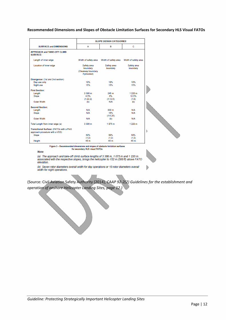
Recommended Dimensions and Slopes of Obstacle Limitation Surfaces for Secondary HLS Visual FATOs
(Source: Civil Aviation Safety Authority (2014), CAAP 92‐2(2) Guidelines for the establishment and
operation of onshore Helicopter Landing Sites, page 12.)

Guideline: Protecting Strategically Important Helicopter Landing Sites Page | 13
Approach and Take‐off Surfaces – “A” slope profile – 4.5% design
(Source: Civil Aviation Safety Authority (2014), CAAP 92‐2(2) Guidelines for the establishment and
operation of onshore Helicopter Landing Sites, page 13.)
Transitional Surface for a FATO with a Point‐in‐Space (PinS) approach procedure with a VSS
(Source: Civil Aviation Safety Authority (2014), CAAP 92‐2(2) Guidelines for the establishment and
operation of onshore Helicopter Landing Sites, page 15.)

Guideline: Protecting Strategically Important Helicopter Landing Sites Page | 14
Back up Profile for the Airbus H135 Helicopter
Cat. A VTOL Rearward Flight Path Surface Level Heliport Obstacle Clearance for H135.
(Source: Eurocopter (now Airbus Helicopters) ‘Figure C23 Rearward Flight Path (VTOL)’, Flight Manual EC
135 P2+ Rev.10)
Guideline: Protecting Strategically Important Helicopter Landing Sites Page | 15
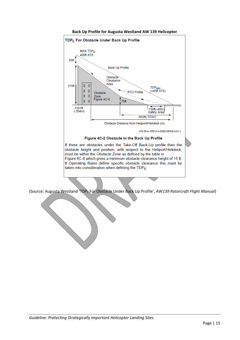
Back Up Profile for Augusta Westland AW 139 Helicopter
(Source: Augusta Westland ‘TDPE For Obstacle Under Back Up Profile’, AW139 Rotorcraft Flight Manual)