Embed Size (px)
Citation preview
28 February 2017
This publication was produced for review by the United States Agency for International Development. It was prepared by Deloitte Consulting LLP. The author’s views expressed in this publication do not necessarily reflect the views of the United States Agency for International Development or the United States Government.
GUIDE TO SUPPORT THE METHODOLOGY FOR THE ASSESSMENT
OF ENVIRONMENTAL FLOWS FOR THE RIVERS AND
STREAMS OF GEORGIA
USAID GOVERNING FOR GROWTH (G4G) IN GEORGIA
USAID | GOVERNING FOR GROWTH (G4G) IN GEORGIA Guide i
GUIDE TO SUPPORT THE METHODOLOGY FOR THE
ASSESSMENT OF ENVIRONMENTAL FLOWS FOR
THE RIVERS AND STREAMS OF GEORGIA
USAID GOVERNING FOR GROWTH (G4G) IN
GEORGIA
CONTRACT NUMBER: AID-114-C-14-00007
DELOITTE CONSULTING LLP
USAID | GEORGIA
USAID CONTRACTING OFFICER’S
REPRESENTATIVE: REVAZ ORMOTSADZE
AUTHOR(S): GEORGIA’S ENVIRONMENTAL
OUTLOOK
WORK PLANNING: WATER RESOURCES
MANAGEMENT
LANGUAGE: ENGLISH
28 FEBRUARY 2017
DISCLAIMER:
This publication was produced for review by the United States Agency for International Development. It was prepared by Deloitte Consulting LLP. The author’s views expressed in this publication do not necessarily reflect the views of the United States Agency for International Development or the United States Government.

USAID | GOVERNING FOR GROWTH (G4G) IN GEORGIA Guide ii
DATA Reviewed by: Giorgi Chikovani, Mariam Bakhtadze, Keti Skhireli
Project Component: Water Resource Management Component
Practice Area: Water Resource Management
Key Words: Environmental flow, Water Framework Directive, methodology
development, flow-habitat simulation modeling, ecosystem approach,
Georgia
USAID | GOVERNING FOR GROWTH (G4G) IN GEORGIA Guide iii
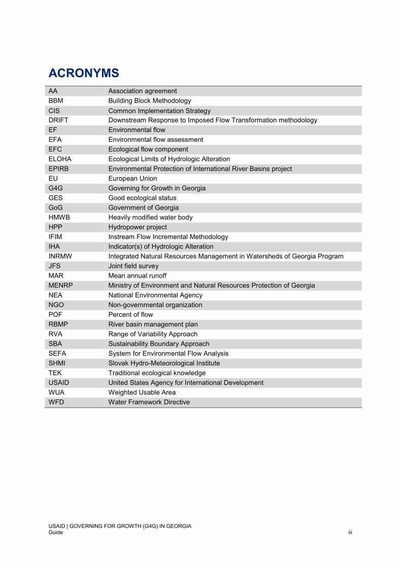
ACRONYMS AA Association agreement
BBM Building Block Methodology
CIS Common Implementation Strategy
DRIFT Downstream Response to Imposed Flow Transformation methodology
EF Environmental flow
EFA Environmental flow assessment
EFC Ecological flow component
ELOHA Ecological Limits of Hydrologic Alteration
EPIRB Environmental Protection of International River Basins project
EU European Union
G4G Governing for Growth in Georgia
GES Good ecological status
GoG Government of Georgia
HMWB Heavily modified water body
HPP Hydropower project
IFIM Instream Flow Incremental Methodology
IHA Indicator(s) of Hydrologic Alteration
INRMW Integrated Natural Resources Management in Watersheds of Georgia Program
JFS Joint field survey
MAR Mean annual runoff
MENRP Ministry of Environment and Natural Resources Protection of Georgia
NEA National Environmental Agency
NGO Non-governmental organization
POF Percent of flow
RBMP River basin management plan
RVA Range of Variability Approach
SBA Sustainability Boundary Approach
SEFA System for Environmental Flow Analysis
SHMI Slovak Hydro-Meteorological Institute
TEK Traditional ecological knowledge
USAID United States Agency for International Development
WUA Weighted Usable Area
WFD Water Framework Directive
USAID | GOVERNING FOR GROWTH (G4G) IN GEORGIA Guide iv
PREFACE
The Government of Georgia has signed an Association Agreement with the European Union (EU) and started towards implementation of the Water Framework Directive (WFD). It has therefore elected to align its proposed national methodology and stepwise procedures for establishing environmental flows for the rivers and streams within its territory with the broader set of guidance presently in place to support the WFD.
The WFD is aimed at maintaining and improving the quality of aquatic ecosystems in the EU. The WFD, as well as the Birds and Habitats Directives, set binding objectives on the protection and conservation of water-dependent ecosystems. These objectives can only be reached if supporting flow regimes are guaranteed (Common Implementation Strategy (CIS) 2015: Ecological flows in the implementation of the Water Framework Directive. Guidance Document No. 31. Technical Report - 2015 – 086. European Commission. 108 pp.).
The WFD requires surface water classification through the assessment of ecological status, or ecological potential in the specific case of heavily modified water bodies (HMWB), and surface water chemical status. Three groups of quality elements must be used for the assessment of ecological status/potential, viz.:
biological elements;
hydromorphological elements supporting the biological elements; and
chemical and physical-chemical elements supporting the biological elements.
The hydrological regime forms part of the hydromorphological quality elements and is recognised as a relevant variable that affects the ecological status of all categories of surface water bodies (i.e., rivers, lakes, transitional waters or coastal waters). A general description of ecological flows has therefore been provided within the context of WFD implementation as “an hydrological regime consistent with the achievement of the environmental objectives of the WFD in natural surface water bodies as mentioned in Article 4(1)”.
Under Article 4(1) of the WFD, the environmental objectives refer in general terms to:
Non-deterioration of the existing status of rivers.
Achievement of Good Ecological Status (GES) in a natural surface water body.
Compliance with standards and objectives for protected areas, as defined by the different international and national conventions and directives that apply in each instance, including those designated for the protection of habitats and species where the maintenance or improvement of the status of water is an important factor for their protection.
It is recognized that the policy and legislative frameworks for water resources management in Georgia remain under development. Thus, various interlinkages between the environmental flow methodology outlined below and related procedures under the legislation will require further alignment in the future.
USAID | GOVERNING FOR GROWTH (G4G) IN GEORGIA Guide v
CONTENTS
ACRONYMS .......................................................................................................................................... III
PREFACE .............................................................................................................................................. IV
CONTENTS............................................................................................................................................. V
1. INTRODUCTION ........................................................................................................................... 1
1.1. CONTEXT ..................................................................................................................................... 1
1.2. ENVIRONMENTAL FLOW ASSESSMENT IN THE CONTEXT OF THE EUROPEAN UNION
WATER FRAMEWORK DIRECTIVE ..................................................................................................... 1
1.3. POLICY AND LEGISLATIVE CONTEXT OF GEORGIA ............................................................. 2
1.4. CURRENT APPROACH FOR ENVIRONMENTAL FLOW ASSESSMENT IN GEORGIA ......... 2
1.5. OVERVIEW OF THE NEW ENVIRONMENTAL FLOW METHODOLOGY FOR GEORGIA ...... 3
1.5.1 Background and rationale for the proposed approach.......................................................... 3
1.5.2 Synopsis of the new methodology ........................................................................................ 5
1.5.3 General considerations for methodology application in the current Georgian context ......... 9
1.5.4 Limitations of the methodology ............................................................................................. 9
1.5.5 Recommended reading ....................................................................................................... 10
2. UNDERSTANDING THE CONCEPTUAL FOUNDATION SUPPORTING ENVIRONMENTAL
FLOW DETERMINATION ........................................................................................................... 11
2.1. IMPORTANT PRINCIPLES AND CONCEPTS .......................................................................... 11
2.1.1 Importance and key characteristics of the natural hydrological regime .............................. 11
2.1.2 Ecological roles of different kinds of flow events ................................................................ 12
2.1.3 Ecohydraulics and the physical habitat template ................................................................ 13
2.2. THE HOLISTIC BASIS OF THE METHODOLOGY ................................................................... 13
2.2.1 Overview of the main types of methodology for environmental flow determination ........... 13
2.2.2 Features of an holistic methodology ................................................................................... 14
3. GUIDE TO THE MAIN STEPS IN THE METHODOLOGY ......................................................... 17
3.1. INTRODUCTION ......................................................................................................................... 17
3.2. PREPARATORY STAGE OF THE ENVIRONMENTAL FLOW ASSESSMENT (STEPS 1-2) . 17
3.2.1 Scoping and initiation of the EFA ........................................................................................ 17
3.2.2 Appointment of the team for the environmental flow assessment ...................................... 17
3.3. DELINEATION OF THE STUDY AREA AND SELECTION OF ENVIRONMENTAL FLOW
SITES (STEP 3) .................................................................................................................................... 19
3.3.1 Delineation of the study area .............................................................................................. 19
3.3.2 Site selection and criteria .................................................................................................... 19
USAID | GOVERNING FOR GROWTH (G4G) IN GEORGIA Guide vi
3.4. DESKTOP AND FIELD HYDROLOGICAL, MORPHOLOGICAL, ECOLOGICAL AND SOCIAL
SURVEYS AND ANALYSES FOR EACH ENVIRONMENTAL FLOW SITE (STEP 4) ...................... 20
3.4.1 Collation of available data, information and knowledge ..................................................... 20
3.4.2 Desktop situation assessment and screening of flow-related impacts ............................... 21
3.4.3 Desktop and field hydrological, morphological, ecological and social surveys and
analyses ............................................................................................................................................ 22
3.5. DEFINITION OF REFERENCE CONDITIONS (STEP 5) ........................................................... 23
3.6. IDENTIFICATION OF RIVER TYPE(S) (STEP 6) ...................................................................... 23
3.6.1 Case example of a system for developing a river typology ................................................ 23
3.7. CLASSIFICATION OF PRESENT STATUS (STEP 7) ............................................................... 25
3.7.1 Classification of present status under the EU WFD ............................................................ 26
3.8. SETTING ENVIRONMENTAL FLOW OBJECTIVES (STEP 8) ................................................. 30
3.9. HYDROLOGICAL CHARACTERISATION OF EACH OF THE ENVIRONMENTAL FLOW
SITES (STEP 9) .................................................................................................................................... 31
3.9.1 Characteristics of the hydrological regime .......................................................................... 32
3.9.2 Hydrological regime alteration ............................................................................................ 34
3.9.3 Key features of the hydrological regime of river types of Georgia ...................................... 35
3.9.4 Key references and recommended reading ........................................................................ 37
3.10. DETERMINATION OF THE SURVIVAL FLOW (STEP 10) ................................................... 38
3.11. DETERMINATION OF ECOLOGICALLY AND SOCIALLY RELEVANT LOW FLOW
PERIODS AND HIGH FLOW EVENTS (STEPS 11 AND 12) .............................................................. 38
3.11.1 Linking hydrology and ecology ............................................................................................ 39
3.11.2 Morphology ......................................................................................................................... 41
3.11.3 Fish and the use of habitat simulation modelling as a tool for environmental flow
assessment ....................................................................................................................................... 43
3.11.4 Macroinvertebrates ............................................................................................................. 49
3.11.5 Water quality ....................................................................................................................... 50
3.11.6 Vegetation ........................................................................................................................... 51
3.11.7 Social survey and analysis .................................................................................................. 51
3.12. COMPLETION OF THE ENVIRONMENTAL FLOW REQUIREMENT SCHEDULE
(STEP 13).............................................................................................................................................. 52
3.13. MONITORING AND REPORTING (STEP 14) ....................................................................... 52
4. CONCLUDING REMARKS ......................................................................................................... 54
REFERENCES ...................................................................................................................................... 56
ANNEXES ............................................................................................................................................. 62

USAID | GOVERNING FOR GROWTH (G4G) IN GEORGIA Guide vii
1
1. INTRODUCTION
1.1. CONTEXT
The Government of Georgia (GoT) has an Association Agreement (AA) with the European Union (EU) and has started to align its water policies and practice with the EU Water Framework Directive (WFD). The national methodology and its stepwise procedures for establishing environmental flows for the rivers and streams of Georgia (see USAID G4G 2017) are therefore aligned with the general ecological flow and other related guidance presently in place to support the countries implementing the WFD.
1.2. ENVIRONMENTAL FLOW ASSESSMENT IN THE CONTEXT OF THE EUROPEAN UNION WATER FRAMEWORK DIRECTIVE
The EU WFD’s main objectives are to prevent deterioration of the status of all water bodies and to protect, enhance and restore all water bodies, with the aim of achieving good ecological status (GES). The European Union member states are mandated under the WFD to achieve GES in all waterbodies (except for “heavily modified water bodies” where only “good ecological potential” has to be met, see below).
Over abstraction of water is reported to be the second most common pressure affecting the ability of EU member states to achieve such good ecological status of their rivers, lakes and other waterbodies (WFD CSI 2015). It is also recognised that water quantity and quality are intimately related within the concept of good status or potential. Environmental flows play a vital role in helping ensure that any new significant alterations in hydrological regime are actively prevented, supporting the general WFD principle of ensuring non-deterioration in the status of water bodies (WFD CIS 2015).
When assessing the status of a surface water body, three elements of quality have to be considered:
1. Biological 2. Hydromorphological 3. Physicochemical
The hydrological regime is explicitly identified in the WFD as an element of ecological status, hereby recognising that ecologically appropriate hydrological regimes are necessary to meet the WFD requirements for implementation. In fact, the binding objectives on protection and conservation of water-dependent ecosystems set out in the WFD, as well as in the Birds and Habitats Directives, can only be reached “if supporting flow regimes are guaranteed” (WFD CIS 2015). The general framework for implementation of ecological (or environmental) flows is set out in the WFD. Within it, ecological flows are broadly acknowledged as representing the "amount of water required for the aquatic ecosystem to continue to thrive and provide the services we rely upon" (WFD CIS 2015). A more specific working description of ecological flows, provided for WFD implementation (WFD CIS 2015) is “an hydrological regime consistent with the achievement of the environmental objectives of the WFD in natural surface water bodies as mentioned in Article 4(1)”.
Under Article 4(1) of the WFD, the environmental objectives refer to:
- Non deterioration of the existing status of rivers
- Achievement of Good Ecological Status in a natural surface water body
- Compliance with standards and objectives for protected areas, as defined by the different (national and) international conventions and directives that apply in each instance, including the ones designated for the protection of habitats and species where the maintenance or improvement of the status of water is an important factor for their protection.
In the specific cases where water bodies can be designated as heavily modified water bodies and/or qualify for an exemption, related requirements in terms of flow regime are to be derived considering technical feasibility and socio-economic impacts on the use that would be affected by the implementation of ecological flows.
2
1.3. POLICY AND LEGISLATIVE CONTEXT OF GEORGIA
Environmental flows are considered an important water resources management tool to help safeguard the water resources of Georgia and maintain good ecological conditions of the country’s rivers, streams and other waterbodies. Many water development plans, including those for variously sized hydropower projects (HPPs), are being formulated to provide greater water security and other social benefits. It is therefore critically important to ensure that the considerable socioeconomic benefits already provided by the country’s healthy freshwater ecosystems are not lost and that already degraded ecosystems are restored to at least a good status. The imperative to incorporate ecosystem needs for freshwater into basin-wide and regional water resources planning is also recognized at national scale.
The following laws, in varying stages of development at present, are pertinent in laying the foundation for environmental flows and should be consulted during the scoping stage (the first step of the methodology) of any environmental flow assessment:
- The present draft Law “On Water Resources Management” prepared by MENRP is expected to be adopted mid-2017; the AA deadline for adoption of the law is September 2018. The law refers to environmental flows and considers the adoption of a bylaw on the topic.
- The new draft Law “Environmental Assessment Code” establishes a legal basis for regulating issues related to development projects and strategic documents, the implementation of which may have significant impact on the environment, human life and health (Article 1). It regulates “the procedures related to environmental impact assessment, strategic environmental assessment, transboundary environmental impact assessment, public participation in decision-making and carrying out expertise” (Article 1). The Draft Environmental Assessment Code is already submitted to the Parliament for adoption. The Code will replace existing laws “On Environmental Impact Permits” and “On Ecological Expertise” regulating procedures related to environmental impact permits, including environmental impact assessment (EIA), public participation, EIA review and decision making as well as post decision making surveillance and control.
For the Ministry (MENRP) and Environmental Impact Permits Department, it is difficult at present to specify the appropriate environmental flow requirement in each instance where a permit is sought for a proposed water infrastructure project for sectoral water use (i.e. energy, notably hydropower; municipal and domestic water supply; irrigation; and/or industry). Therefore, it is recognised as essential that the proposed new methodology is approved and adopted at the national level. Its formal status would place an obligation on project developers, in the same way as for other regulations, to conduct a reproducible, rigorous and scientifically defensible environmental flow assessment (EFA) sufficiently early on in the project water resources/hydropower engineering cycle. It would also confer greater reliability in the results, helping to preclude individual interpretations by project developers and facilitate adaptive management and compliance.
1.4. CURRENT APPROACH FOR ENVIRONMENTAL FLOW ASSESSMENT IN GEORGIA
The method for environmental flow assessment historically, and still currently, applied in Georgia is a desktop hydrological method based on a former Soviet Era approach. As such, it has the same kinds of limitations (low resolution and confidence, low ecological relevance) and advantages (e.g. rapid, reliant only on hydrological data) characteristic of other simple methods of this category (see Section 2.2 and Tharme 2003, for further discussion).
In brief, minimum flow statistics are used to estimate the flow regime under different kinds of hydromorphological alterations of a river. Past practice has been to assign 10% of the Mean Annual Runoff (MAR), based on the available hydrological time series of observed data, as a year-round, constant minimum discharge in the river at the particular project site (e.g. a hydropower dam or major municipal water abstraction point). No consideration is given to the type of river or stream, or to seasonal flow levels or other ecologically and socially important aspects of the flow regime and its characteristic variability over the year or among years. No ecological or social expertise, knowledge or data are explicitly required or form part of the process of environmental flow determination using
3
this former 10% MAR approach. Furthermore, the resultant environmental flow recommendations can be seen to be considerably lower than those recommended using methods that are more in line with good practice.
1.5. OVERVIEW OF THE NEW ENVIRONMENTAL FLOW METHODOLOGY FOR GEORGIA
1.5.1 BACKGROUND AND RATIONALE FOR THE PROPOSED APPROACH
There is a wide range of methodologies concerning environmental flows in use across all world regions (Tharme 2003; Acreman and Ferguson 2010; Poff et al. 2010; Poff et al. 2017). Various useful, in-depth reviews of the current frameworks, procedures and types of methodologies that can be used for establishing environmental flows in various countries around the world, including Europe, can be found in, among others, the following reference sources: Tharme (2003); Annear et al. (2004); Acreman and Dunbar (2004); Acreman and Ferguson (2010); Arthington (2012) and most recently, Poff et al. (2017).
Nowadays, many countries have adopted elements of best practice, with a specific set of guiding principles and a methodology or tiered set of methodologies in place, for establishing an environmental flow regime at different scales, levels of resolution and resource intensity. However, some countries are still in an early stage of environmental flow policy and practice, or set environmental flows on an ad hoc case by case basis. While implementation remains a challenging process worldwide, there has been significant progress in recent years, particularly though linking of the procedures for environmental flow determination directly to national policy, legislation and regulatory frameworks, as well as embedding the process within basin scale procedures for water allocation planning and management (Le Quesne et al. 2010; Horne et al. 2017).
The recommended new environmental flow methodology for Georgia was founded on an earlier draft methodology formulated in a framework of the USAID Project Integrated Natural Resources Management in Watersheds of Georgia (INRMW). It is in large part based on two current methodologies, namely the Austrian method for calculating environmental flows and the methodology devised for the State of Connecticut, USA. Both approaches are well established and are required under current legislation in their places of origin. They incorporate holistic and habitat simulation elements (see Section 2.2, for explanation of these methodology types).
The rationale for reviewing the Austrian method for potential application in Georgia and subsequent incorporation of some of its key elements (e.g. a survival flow, Section 3.9), included a common orientation towards meeting the requirements of the European Water Framework Directive, as well as similarities in geography, catchment physiographic features and river types. Reference was made to the guiding values used to define a good hydromorphological status under the Austrian Quality Objective Ordinance, Ecological Status of Surface Waters (March 2010), Chapter 2, Article 2, “Quality objectives and guiding values for the hydromorphological quality elements” (Box 1.1). The approach considers a variable flow regime, including a minimum discharge, critical low flows, biologically defined significant low flow and high flow periods, and flows to meet cultural objectives.
4
Other methodologies applied in Europe, were also assessed in terms of their procedures and
applicability in the Georgian context (e.g. Acreman and Ferguson 2010; Poff et al. 2017). For
example, the environmental flow methodologies of the Czech Republic and Armenia refer to a “natural
state of emergency” base flow (natural mean annual ten-day minimum flow) which naturally occurs
rarely; no water abstraction is allowed during this period to prevent ecological deterioration. Based on
an analysis of the results of various EFAs globally, including European studies, one generic guide
proposed that environmental flows should be maintained in the range 25-50 % of the natural mean
annual flow, to ensure suitable conditions for aquatic organisms to survive and reproduce (Sánchez
Navarro and Schmidt 2012).
The US State of Connecticut Department of Energy and Environmental Protection, Stream Flow
Standards and Regulations, Section 26-141b-1 to 26-141b-8, inclusive of the Regulations of
Connecticut State Agencies (effective December 12, 2011) also relies on the use of bioperiods to
establish environmental flows. The state shows similarities with Georgia in some of its anadromous
fish species and their life cycles (e.g. shad, salmon, sturgeon) and therefore has experience to share
in the flows recommended for migratory species that move between freshwater and coastal
ecosystems. This was a necessary consideration given the longitudinal connectivity of several major
Georgian river systems with the Black Sea.
The proposed methodology for Georgia has also benefited considerably from recent developments in
ecohydrological sciences, as well as from the experience gained through the routine application of
holistic methodologies (Section 2.2) in various regions worldwide (Tharme 2003), including the
Building Block Methodology (BBM) and Downstream Response to Imposed Transformation (DRIFT)
framework applied extensively in southern and eastern Africa (e.g. USAID 2016) and parts of Asia. It
has been further enriched through the exchange of lessons learned during recent advancements
made in several countries, notably Spain, the USA and New Zealand, in the field of ecohydraulics,
specifically in habitat simulation modelling methods and tools (e.g. Milhous et al. 1984; Stalnaker et al.
1994; Jowett 1997; Bovee et al. 1998; Payne et al. 2004; Muñoz-Mas et al. 2016; Payne and Jowett
Undated, and references therein).
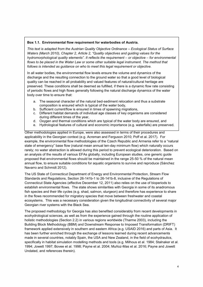
Box 1.1. Environmental flow requirement for waterbodies of Austria.
This text is adapted from the Austrian Quality Objective Ordinance – Ecological Status of Surface
Waters (March 2010), Chapter 2, Article 2, “Quality objectives and guiding values for the hydromorphological quality elements”. It reflects the requirement – or objective – for environmental
flows to be placed in the Water Law or some other suitable legal instrument. The method that
follows is intended as guidance on who to meet this legal requirement or objective.
In all water bodies, the environmental flow levels ensure the volume and dynamics of the
discharge and the resulting connection to the ground water so that a good level of biological
quality can be reached in all probability and valued features of natural/cultural heritage are
preserved. These conditions shall be deemed as fulfilled, if there is a dynamic flow rate consisting
of periodic flows and high flows generally following the natural discharge dynamics of the water
body over time to ensure that:
a. The seasonal character of the natural bed-sediment relocation and thus a substrate composition is ensured which is typical of the water body,
b. Sufficient current/flow is ensured in times of spawning migrations, c. Different habitat demands of individual age classes of key organisms are considered
during different times of the year, d. Oxygen and thermal conditions which are typical of the water body are ensured, and e. Hydrological features of cultural and economic importance (e.g. waterfalls) are preserved.
5
1.5.2 SYNOPSIS OF THE NEW METHODOLOGY
The proposed new methodology for the assessment of environmental flows for the rivers and streams of Georgia will wholly replace the present methodology described above. It is based on the following internationally accepted definition of an environmental flow (Brisbane Declaration 2007):
An environmental flow is defined as: the quantity, timing, and quality of water flows and levels required to sustain freshwater ecosystems and the human livelihoods and well-being that depend on these ecosystems.
In terms of its mode of application, the methodology may be applied in any river or stream section to determine the flow levels needed to meet social-ecological objectives. It has been assumed that it will normally be applied as part of an Environmental Impact Assessment related to the request for an environmental permit or license, although it is strongly advised that the methodology be applied as early in the project planning process as possible. The methodology is designed to be sufficiently flexible and reliable for routine application in contexts including variable availability of data, expertise and technical capacity. Key guiding principles for its application are summarized in Box 1.2.
As an holistic type methodology that addresses the flow requirements of the whole-ecosystem, it is founded on well accepted ecohydrological, ecohydraulics and other relevant tenets and concepts that reflect global best practice (Tharme 2003; Section 2.1). It also takes special account of the physical habitat needs of key instream biota by incorporating hydraulic habitat simulation as an additional approach (Section 4.3). It is interdisciplinary in nature and makes best use of existing knowledge and expert judgement. This makes it particularly useful in data-deficient situations.
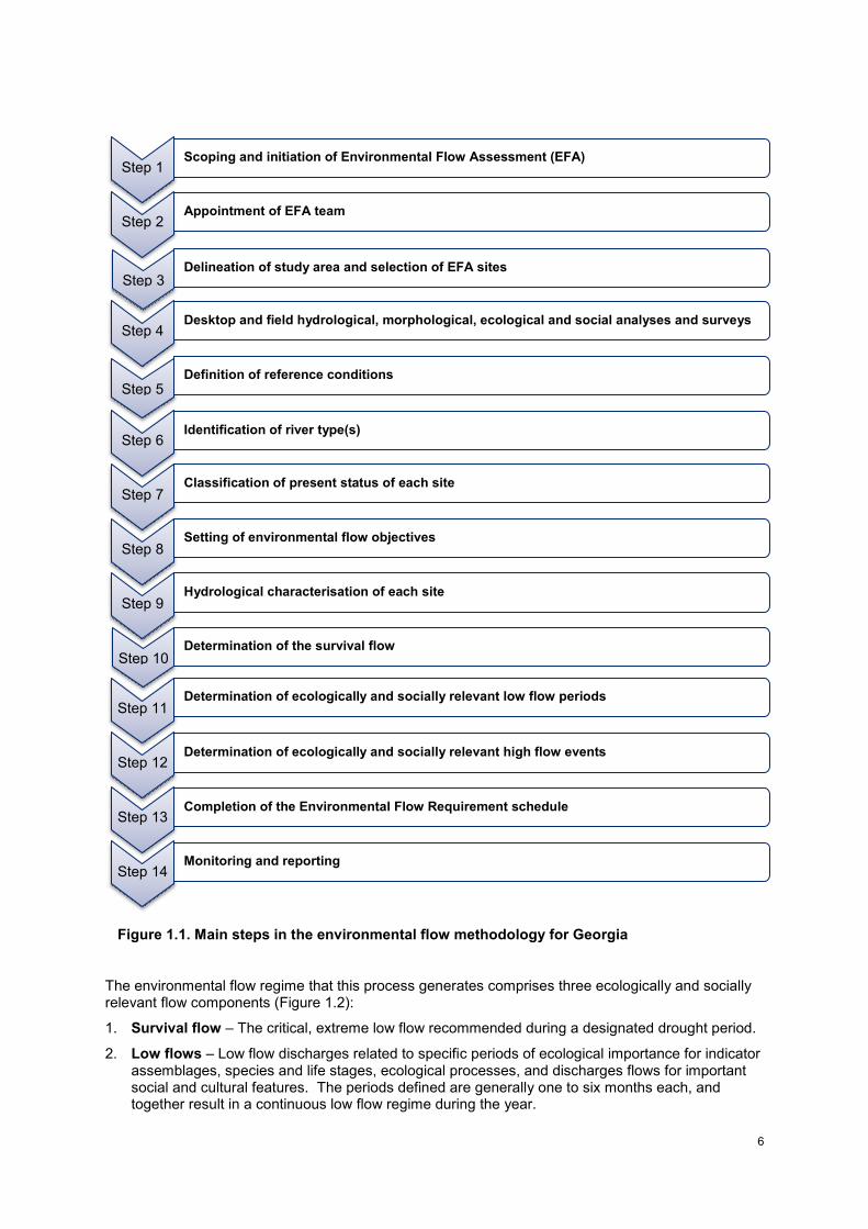
The methodology comprises 14 basic steps (as outlined in the USAID G4G methodology for the assessment of environmental flows for the rivers and streams of Georgia, 2017; Figure 1.1).
Box 1.2. Guiding principles for application of the new methodology.
- In the absence of sufficient data and information about the flow requirements of freshwater species in a given river or stream, the precautionary principle should apply.
- There is no single minimum constant flow year-round that will maintain ecosystem health. It is important to maintain and mimic as far as possible the natural patterns of flow variability of the river.
- Environmental flow levels cannot be defined purely on hydrological grounds. There must also be consideration of morphological, physico-chemical, ecological and social information.
- Flow levels to meet ecological requirements are related to the natural flow regime (or other reference flow regime) of the river or stream under consideration.
- An holistic interdisciplinary method for assessing environmental flow requirements is required.
6
Figure 1.1. Main steps in the environmental flow methodology for Georgia
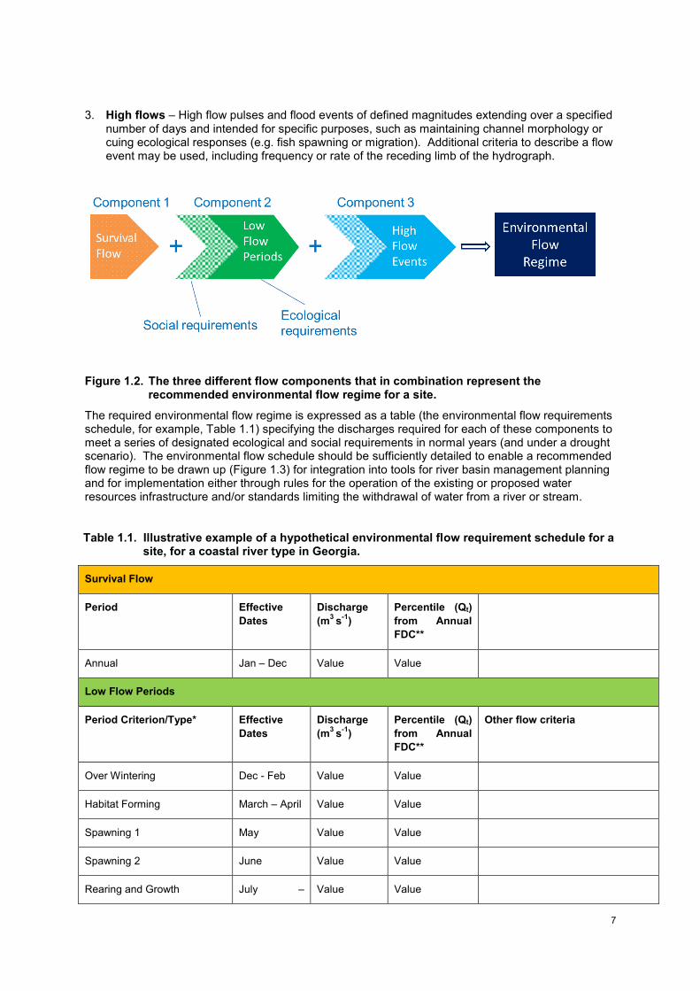
The environmental flow regime that this process generates comprises three ecologically and socially relevant flow components (Figure 1.2):
1. Survival flow – The critical, extreme low flow recommended during a designated drought period.
2. Low flows – Low flow discharges related to specific periods of ecological importance for indicator assemblages, species and life stages, ecological processes, and discharges flows for important social and cultural features. The periods defined are generally one to six months each, and together result in a continuous low flow regime during the year.
Step 1 Scoping and initiation of Environmental Flow Assessment (EFA)
Step 2 Appointment of EFA team
Step 3
Delineation of study area and selection of EFA sites
Step 4 Desktop and field hydrological, morphological, ecological and social analyses and surveys
Step 5
Definition of reference conditions
Step 7
Classification of present status of each site
Step 8
Setting of environmental flow objectives
Step 9
Hydrological characterisation of each site
Step 10
Determination of the survival flow
Step 11
Determination of ecologically and socially relevant low flow periods
Step 12 Determination of ecologically and socially relevant high flow events
Step 13 Completion of the Environmental Flow Requirement schedule
Step 14 Monitoring and reporting
Step 6 Identification of river type(s)
7
3. High flows – High flow pulses and flood events of defined magnitudes extending over a specified number of days and intended for specific purposes, such as maintaining channel morphology or cuing ecological responses (e.g. fish spawning or migration). Additional criteria to describe a flow event may be used, including frequency or rate of the receding limb of the hydrograph.
Figure 1.2. The three different flow components that in combination represent the recommended environmental flow regime for a site.
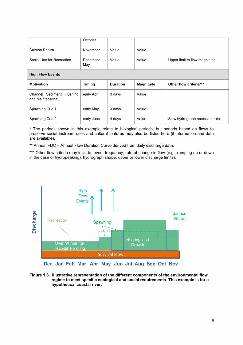
The required environmental flow regime is expressed as a table (the environmental flow requirements schedule, for example, Table 1.1) specifying the discharges required for each of these components to meet a series of designated ecological and social requirements in normal years (and under a drought scenario). The environmental flow schedule should be sufficiently detailed to enable a recommended flow regime to be drawn up (Figure 1.3) for integration into tools for river basin management planning and for implementation either through rules for the operation of the existing or proposed water resources infrastructure and/or standards limiting the withdrawal of water from a river or stream.
Table 1.1. Illustrative example of a hypothetical environmental flow requirement schedule for a site, for a coastal river type in Georgia.
Survival Flow
Period Effective
Dates
Discharge
(m3
s-1
)
Percentile (Qt)
from Annual
FDC**
Annual Jan – Dec Value Value
Low Flow Periods
Period Criterion/Type* Effective
Dates
Discharge
(m3
s-1
)
Percentile (Qt)
from Annual
FDC**
Other flow criteria
Over Wintering Dec - Feb Value Value
Habitat Forming March – April Value Value
Spawning 1 May Value Value
Spawning 2 June Value Value
Rearing and Growth July – Value Value
8
October
Salmon Return November Value Value
Social Use for Recreation December –
May
Value Value Upper limit to flow magnitude
High Flow Events
Motivation Timing Duration Magnitude Other flow criteria***
Channel Sediment Flushing
and Maintenance
early April 3 days Value
Spawning Cue 1 early May 3 days Value
Spawning Cue 2 early June 4 days Value Slow hydrograph recession rate
* The periods shown in this example relate to biological periods, but periods based on flows to preserve social instream uses and cultural features may also be listed here (if information and data are available).
** Annual FDC – Annual Flow Duration Curve derived from daily discharge data.
*** Other flow criteria may include: event frequency, rate of change in flow (e.g., ramping up or down in the case of hydropeaking), hydrograph shape, upper or lower discharge limits).
Figure 1.3. Illustrative representation of the different components of the environmental flow regime to meet specific ecological and social requirements. This example is for a hypothetical coastal river.
9
1.5.3 GENERAL CONSIDERATIONS FOR METHODOLOGY APPLICATION IN THE CURRENT GEORGIAN CONTEXT
For any planned EFA, it is important to be aware of the general considerations and assumptions that apply for the methodology, as outlined in the methodology text. The team undertaking the assessment should also be familiar with the methodology’s core guiding principles (Box 1.2).
In the absence of sufficient data and information about the flow requirements of the river or stream ecosystem and its species, the precautionary principle should apply and a higher level of flow should be protected. Where a greater degree of confidence is required in the environmental flow recommendations and/or the higher the priority and importance of the river/stream reaches to be affected, a more comprehensive, and therefore also more resource intensive, environmental flow assessment should be conducted. Confidence in and the level of resolution in the resultant environmental flow requirement are typically proportional to the degree of effort invested in the assessment.
At present, certain procedural steps of the environmental flow methodology are in their early stages of development. Moreover, various constraints are known to exist in the availability of data, expertise and technical capacity. While designed to be sufficiently flexible and reliable for routine application in such contexts, the methodology is also amenable to further development and can be expected to evolve over time. Practitioners should therefore aim to use the best available methods and tools known to them in the application of each of the methodology steps. It is also important to clearly document the procedures used.
1.5.4 LIMITATIONS OF THE METHODOLOGY
The methodology is specifically designed for application to perennial rivers and streams. While the procedures should also be applicable for temporary rivers, they were not developed with such systems as the waterbody type. Similarly, estuary and nearshore considerations can be addressed using the approach (e.g. migratory anadromous fish species, eco-periods for control of the estuary saline wedge, flow events for primary productivity in the nearshore coastal zone) although not a direct focus. Methodologies for lakes, groundwater-dependent wetlands and other waterbodies are as yet undeveloped for Georgia, although some examples exist globally to help provide guidance.
The methodology aims to align with proposed procedures for Environmental Impact Assessment (EIA) and Strategic Environmental Assessment (SEA) related to the application process for a license or permit under the (draft) Code of Environmental Assessment for large water resources infrastructure projects. It may need further tailoring for other purposes.
It is not a tiered multi-scale set of procedures and is focused at the site or project level of environmental flow assessment. As such it is limited in not providing additional approaches for rapid, desktop level assessment of environmental flows or a large basin or regional scale approach for setting environmental flow standards to address cumulative flow alteration or multiple water infrastructure projects within a basin; examples of such regional approaches are provided in Poff et al. (2010, 2017) and Arthington (2012). The methodology could be readily adapted, however, for such scales of assessment.
As with other environmental flow methods, it does not directly address the impacts of the physical barriers (e.g. dams, weirs) on the passage of aquatic species such as fish, invertebrates and plant seeds or the implications of system loss of connectivity. Similarly, it is also less able to address changes to sediment and nutrient flows, or thermal regime changes, than alterations to the hydrological regime. Therefore, it is important that complementary efforts are made (e.g. fishways and other bypass structures, connectivity analyses, integrated dam and conservation planning) to address such effects.
Environmental flow assessment only addresses issues of basin flow management. Thus, as is the case with other methodologies globally, recommendations from the Georgia methodology should be integrated with land management and other management solutions to address single and multiple stressors, many of which may not be flow-related (e.g. point source industrial pollution, diffuse agricultural pollution, climate change, and erosion from poor land use practices).

10
1.5.5 RECOMMENDED READING
There are a number of general publications that may be useful to consult in preparation for any EFA in Georgia, including the following: the 2017 environmental flow methodology for Georgia; Sánchez Navarro and Schmidt (2012), which discusses environmental flows as a tool to achieve WFD objectives; the WFD Common Implementation Strategy (CIS) of 2015; and the 2015 report on ecological flows in the implementation of the Water Framework Directive (Guidance Document No. 31).
For background reading on environmental flow methodologies, texts include: Tharme (2003); Acreman and Ferguson (2010); Arthington (2012); Acreman (2016); and Poff et al. (2017).
11
2. UNDERSTANDING THE CONCEPTUAL FOUNDATION SUPPORTING ENVIRONMENTAL FLOW DETERMINATION
2.1. IMPORTANT PRINCIPLES AND CONCEPTS
2.1.1 IMPORTANCE AND KEY CHARACTERISTICS OF THE NATURAL HYDROLOGICAL REGIME
A detailed account of the basic ecohydrological concepts underpinning environmental flow assessment can be found in, among others, Poff et al. (1997), Bunn and Arthington (2002), Lytle and Poff (2004), Arthington (2012) and Acreman (2016); only a summary is provided below.
Several key ecological attributes ensure the integrity, structure and functioning of river and stream ecosystems: hydrological regime; physical habitat conditions; biological composition and interactions; energy supply; water quality (i.e. water chemistry regime); and connectivity. Of these, the flow regime (i.e. the natural pattern and timing of low and high flows and their variability in time and space) is a primary determinant of the structure of aquatic and riparian ecosystems and the processes that govern them. It influences ecological integrity directly and indirectly through physical habitat, water quality, energy (food) sources, biotic interactions, and connectivity. As a master variable, flow also shapes the flow-ecosystem relationships of different human communities, influencing their flow-related ecosystem services dependencies, livelihoods systems, and cultures.
“The full range of natural intra- and inter-annual variation in hydrologic regimes, and associated characteristics of timing, duration, frequency, and rate of change, are critical in sustaining the full native biodiversity and integrity of aquatic ecosystems” (i.e. the natural flow paradigm, Poff et al. 1997). It is therefore recognized that any changes from this natural pattern and timing of flows is likely to exert some effect on the biota and integrity of the ecosystem. Hydrological alteration of river systems can be described simply as any anthropogenic disruption to the timing or magnitude of their natural flows and/or water levels. It also includes the fragmentation effects of the physical barriers created by infrastructure (e.g. by dams, diversion weirs, groundwater abstraction) and other ‘soft’ barriers (e.g. altered thermal and sediment regimes downstream of an impoundment). Hydrology can be altered by a range of factors: dams and diversion weirs, surface water offtakes and withdrawals, pumps for groundwater abstraction, land-use land-cover change (e.g. wetland loss or conversion, deforestation or afforestation with non-native trees), and climate change.
Considerable evidence exists that modifications to streamflow induce ecological alterations, with clear links between changing flow conditions and ecosystem response (as reviewed in Bunn and Arthington 2002; Poff and Zimmerman 2010). It is therefore widely accepted nowadays that a naturally variable regime comprising different high and low flow events, rather than just a minimum, constant low flow year-round, is required to sustain the health of freshwater ecosystems (Poff et al. 1997; Bunn and Arthington 2002; Annear et al. 2004). In rivers where there has been little human modification of flow regimes, environmental flow regimes are typically recommended that mimic the natural flow regime as far as possible (i.e. flow protection, cf. flow restoration in the case of basins already subject to intensive sectoral water use). Nowadays, as riverscapes become ever more modified from natural by a host of human activities, and novel and hybrid river ecosystems become more common catchment features, attention is increasingly geared towards the specific design of flow regimes that maintain rivers at a level of condition that supports the most valued multiple functions and services for people (Acreman et al. 2014a, b).
It is important to understand the type of river system for which a particular EFA is being conducted. Rivers and streams comprise many different types, even within a single country or river basin, based on their catchment physiographic characteristics, hydrology, geomorphology, ecology and associated social systems. Postel and Richter (2003) provide examples of the different kinds of hydrographs associated with different systems (e.g. stable, high volume baseflow rivers; snowmelt, rainfall or groundwater dominated systems; highly flashy intermittent rivers). The different elements of individual
12
river hydrographs and the ways in which they can be meaningfully characterised for environmental flow analysis are described below and in Section 3.9.
2.1.2 ECOLOGICAL ROLES OF DIFFERENT KINDS OF FLOW EVENTS
Bunn and Arthington (2002) formulated four key principles highlighting the importance of the natural flow regime in the conservation of aquatic ecosystems:
1. The hydrological regime is an important determinant of physical habitat, which in turn determines the biotic composition and life history strategies.
2. Aquatic species have evolved in direct response to the natural hydrological regime. 3. Maintaining natural patterns of longitudinal and lateral connectivity is essential for the viability
of populations of species. 4. The success of the invasion of exotic and introduced species is facilitated by the alteration of
hydrological regimes.
Various examples of the importance and roles of different kinds of flow events are provided in Bunn and Arthington (2002) and Postel and Richter (2003), both of which are recommended reading. For example, large floods form and maintain the morphology of the channel and recharge the banks to support riparian trees. Smaller floods may be critical triggers for the migration and spawning of different fish species, and low flow events maintain important instream physical habitat for invertebrates or provide refuge areas.
Environmental flow assessments make use of the best available knowledge and understanding of these varied interrelationships between flow and ecology as a guide for setting flows. As a starting point, it is useful to develop a conceptual ecohydrological (or socio-ecohydrological) model of the river at the site(s) of interest. Such models help guide the identification of the most critical flow events and ecosystem components and processes to focus on from amongst the wide array of possible options.
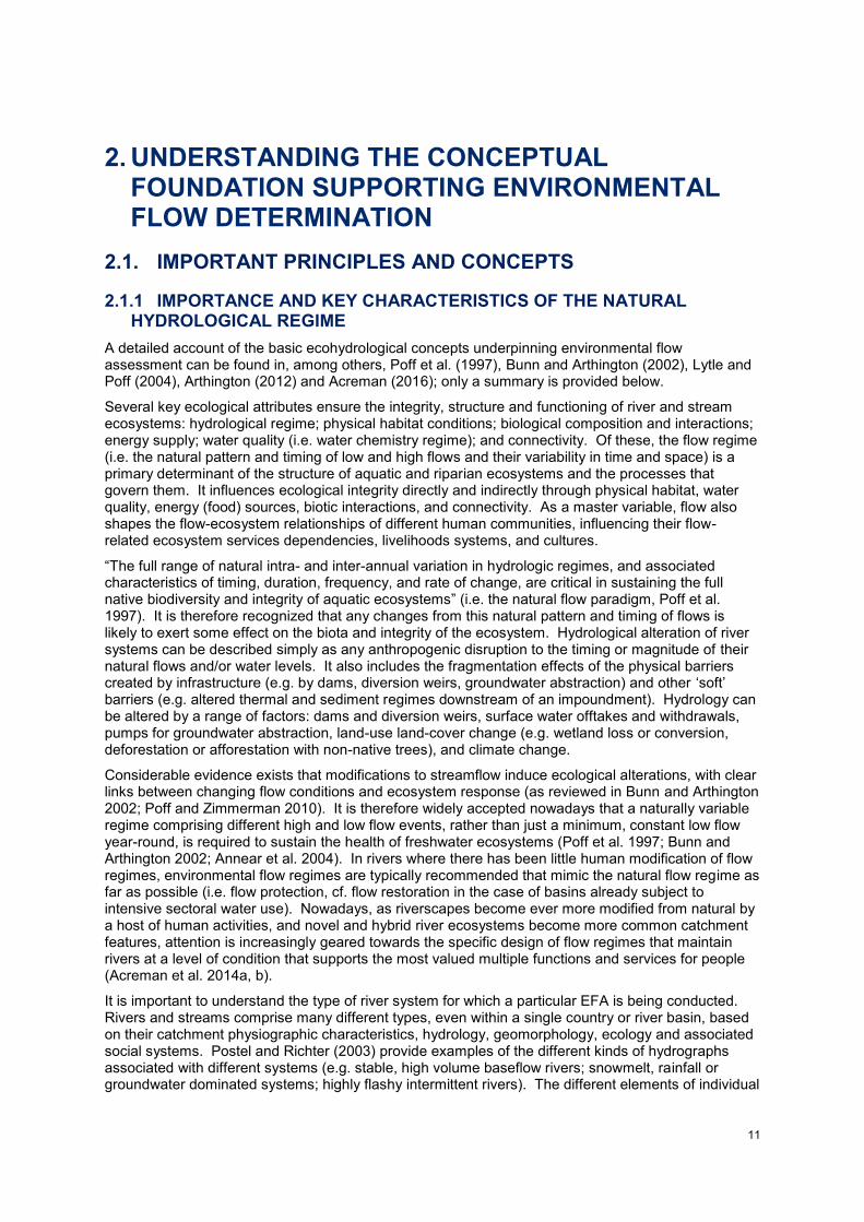
Box 2.1. Building a conceptual model to help identify ecologically and socially important
periods of the year and associated flow events, as well as to develop the supporting
motivations for specific environmental flows.
A conceptual ecohydrological model for the Trinity River, California, USA. Source: The Nature Conservancy.
13
The Trinity River natural hydrograph is flashy and influenced by heavy rains from October to January, followed by snow accumulation in early spring, and then snowpack melting in March to June. Ecological responses linked to the natural form of the hydrograph include the dispersal of seeds by cottonwood trees in late May and early June, coincident with the natural flood recession period, and the transport of young chinook salmon to the ocean. High flows move sediment, shape the channel, and form habitat features such as riffles, pools, gravel bars, islands. They also scour gravels clean for salmon fry to occupy at specific times of the year. In summer, with recession to baseflows, riparian plant species such as willow disperse seeds and grow. Approximately 90% of the flow of the Trinity River is diverted for the Central Valley irrigation Project. As a result of this flow alteration, the river is now a fast-flowing, uniform channel with single-age cottonwood stands, riparian encroachment and channel narrowing, and severely reduced populations of socioeconomically important salmon. Environmental flow restoration efforts for this river have focused on addressing some of the key flow events needed to retain and improve some of these critical ecological and social benefits.
In another example, a socio-ecohydrological conceptual model was constructed for the Kilombero River, Rufiji Basin, Tanzania, with a strong emphasis on the flow dependencies of local communities to support their livelihoods and wellbeing, from key flow events linked to fisheries production to discharges required to support flood recession agriculture and livestock (USAID 2016). This model acted as a guide in the development of specific flow recommendations.
2.1.3 ECOHYDRAULICS AND THE PHYSICAL HABITAT TEMPLATE
It is beyond the scope of this report to provide a review of the theory of ecohydraulics. However, among numerous other authors addressing this field, Davis and Barmuta (1989), Poff and Ward (1990) and Stanford et al. (2005) describe the physical habitat template of lotic systems, its importance in structuring river communities, and its dynamic relationships with the flow regime. Hydraulics may be ordered in a nested hierarchy in much the same way as other river processes, for instance, with trends in hydraulic characteristics reflecting factors such as reach location and stream size (Statzner et al. 1988). Petts et al. (1995) note that at the scale of the river reach “the influence of flow on the distribution of biota is often affected by changing hydraulic conditions rather than by any hydrological parameter per se”. The discipline of ecohydraulics focuses in large part on the spatiotemporal variability in the hydraulic habitat conditions experienced by instream biota (e.g. fish, benthic macroinvertebrates, macrophytes) at different discharges (Statzner et al. 1988). Parameters such as water depth, velocity, bed substratum composition and instream and overhead cover are commonly examined. For instance, Statzner et al. (1988) demonstrated the importance of hydrodynamics and stream hydraulics as key determinants of the distribution and abundance of benthic macroinvertebrates across a wide range of spatial and temporal scales. There is a large body of literature on this topic from which specialists can draw.
Relationships between flow and physical habitat for target biota constitute the basis of the majority of hydraulic and habitat simulation methods for calculating environmental flows, as discussed below and in Section 3.11.
2.2. THE HOLISTIC BASIS OF THE METHODOLOGY
The environmental flow methodology for Georgia is essentially an holistic one. The basis of this type of methodology is important to understand if the methodology is to be properly applied, and is outlined below.
2.2.1 OVERVIEW OF THE MAIN TYPES OF METHODOLOGY FOR ENVIRONMENTAL FLOW DETERMINATION
There are four basic categories of methodologies for assessing environmental flows (see Tharme 2003 and Poff et al. 2017 for details):
1. Hydrological - Use single or multiple flow indices derived from historical flow records to set flow targets for maintaining river health. In some instances, but not all, the flow metrics used are known or assumed to be ecologically relevant.
14
2. Hydraulic Rating - Use changes in simple hydraulic variables with discharge across cross-section(s) as surrogates for habitat factors limiting to target biota (e.g. wetted perimeter, average water depth). These methods are now largely superseded by more sophisticated habitat simulation methods.
3. Habitat Simulation – Model the quantity and suitability of physical habitat for target species (or life history stages, guilds, or assemblages) under different flows. These methods integrate hydrological, hydraulic and biological response data; many evolved from simpler hydraulic rating methods. Such methods are increasingly incorporated as one habitat-based approach within a more comprehensive holistic methodology (as is the case in the methodology for Georgia).
4. Holistic (or whole-ecosystem) – Key flow events for a range of ecosystem components and processes are identified, flow-ecology-geomorphology-social response relationships are modelled, and an interdisciplinary team of experts then typically establishes an environmental flow regime(s) for one or more future ecosystem states or scenarios. Specific motivations for the various flow events comprising the recommended flow regime are provided, for each ecosystem component/process identified.
Tharme (2003) describes the main strengths and deficiencies of these main types of methodologies.
2.2.2 FEATURES OF AN HOLISTIC METHODOLOGY
Holistic methodologies are whole-ecosystem or hydrological-socioecological approaches to flow assessment.
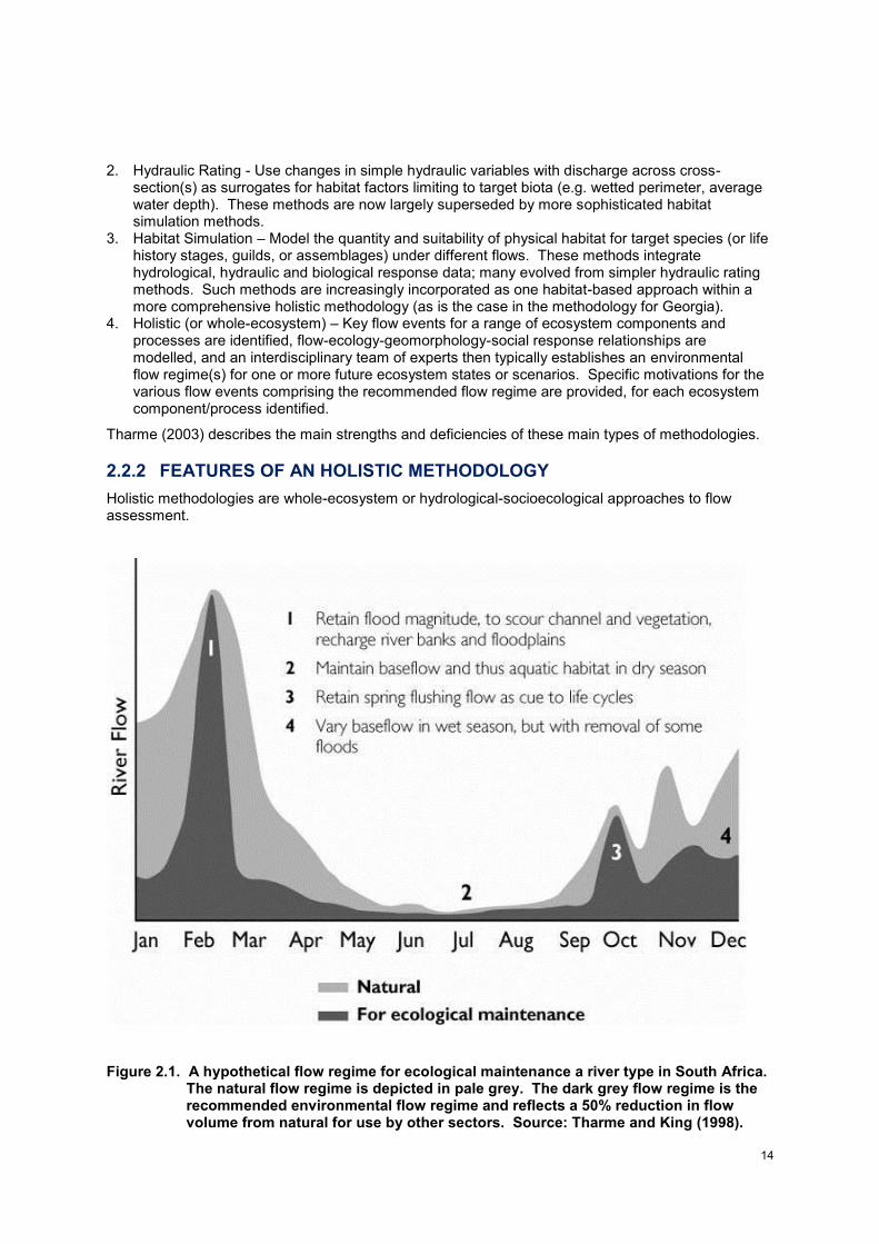
Figure 2.1. A hypothetical flow regime for ecological maintenance a river type in South Africa. The natural flow regime is depicted in pale grey. The dark grey flow regime is the recommended environmental flow regime and reflects a 50% reduction in flow volume from natural for use by other sectors. Source: Tharme and King (1998).
15
Holistic methodologies address the question of which of the potential range of flow events are most important to keep and why (the ecological motivations or reasons) to ensure good ecological status (Figure 2.1). They require the development of a knowledge base on the flow-related conditions governing ecosystem structure and functioning, and under which the biota (fauna and flora) exist at a site. They similarly also require some understanding of the potential impacts of altered flow patterns on all these aspects of the system. Equivalent knowledge on social relationships with flow regime is also developed, where relevant (e.g. flow events that are important for recreation or maintaining valued aesthetic features such as waterfalls).
A structured, stepwise process that is consistently reproducible is an important feature of an holistic methodology that incorporates best expertise and professional judgement, such as the approach for Georgia. See Box 2.1, for an example of the process used to calculate environmental flows using the holistic Building Block Methodology. Richter et al. (2006) describe a collaborative and adaptive process for developing environmental flow recommendations applied in the USA for the Savannah River and other rivers, and other examples are summarised in Arthington (2012) and Poff et al. (2017).
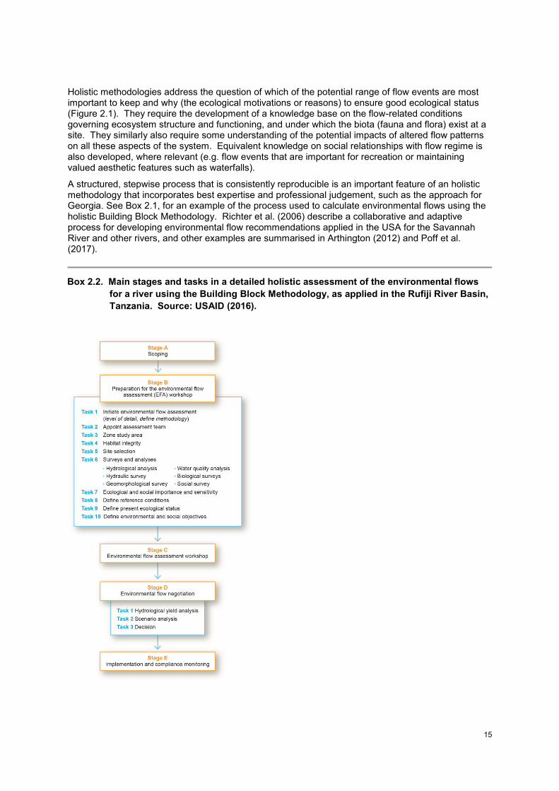
Box 2.2. Main stages and tasks in a detailed holistic assessment of the environmental flows
for a river using the Building Block Methodology, as applied in the Rufiji River Basin,
Tanzania. Source: USAID (2016).
16
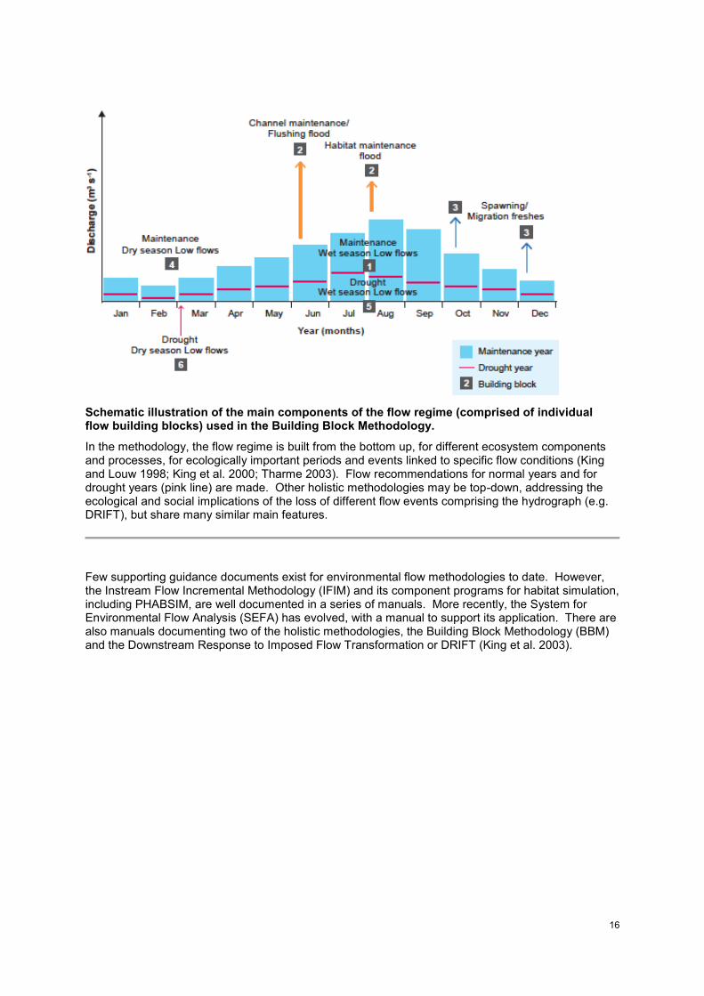
Schematic illustration of the main components of the flow regime (comprised of individual flow building blocks) used in the Building Block Methodology.
In the methodology, the flow regime is built from the bottom up, for different ecosystem components and processes, for ecologically important periods and events linked to specific flow conditions (King and Louw 1998; King et al. 2000; Tharme 2003). Flow recommendations for normal years and for drought years (pink line) are made. Other holistic methodologies may be top-down, addressing the ecological and social implications of the loss of different flow events comprising the hydrograph (e.g. DRIFT), but share many similar main features.
Few supporting guidance documents exist for environmental flow methodologies to date. However, the Instream Flow Incremental Methodology (IFIM) and its component programs for habitat simulation, including PHABSIM, are well documented in a series of manuals. More recently, the System for Environmental Flow Analysis (SEFA) has evolved, with a manual to support its application. There are also manuals documenting two of the holistic methodologies, the Building Block Methodology (BBM) and the Downstream Response to Imposed Flow Transformation or DRIFT (King et al. 2003).
17
3. GUIDE TO THE MAIN STEPS IN THE METHODOLOGY
3.1. INTRODUCTION
This section of the guide is broadly structured according to the main steps outlined in the methodology text (see Section 1.5 and Figure 1.1; UDSAID G4G 2017 - the methodology) and aims to elaborate the supporting guidance each step requires, where necessary.
In addition to the overview of the general context and of the basic concepts that are important to have reviewed and understood (Section 2), for each step or series of steps, the following guides are provided:
- The main activities required, with a brief description of each activity, the expertise required to perform the tasks involved, the basic sets of data and information needed, and select procedures, methods and tools that can be used.
- Supplementary information and key supporting references. Boxes are used to illustrate important points or provide case examples, where such material is particularly useful and readily available.
- Notes highlighting any opportunities or challenges that the proposed step may present under the current phase of development of the environmental flow methodology.
- Annexes with examples of field protocol forms that can be used for an assessment.
3.2. PREPARATORY STAGE OF THE ENVIRONMENTAL FLOW ASSESSMENT (STEPS 1-2)
3.2.1 SCOPING AND INITIATION OF THE EFA
As detailed in the methodology text, an initial scoping of the area of interest should be conducted, supported by the relevant agency or developer, to identify the issues of concern based on the proposed water infrastructure project. At this point, the environmental flow process begins and a coordinator, preferably with some prior experience in environmental flow assessment, needs to be appointed to lead it. An initial plan for the environmental flow assessment needs to be drawn up and agreed by all parties. It should align with current EIA/SEA and related procedures, where relevant, as well as with any existing vision statement or River Basin Management Plan for the basin, where this information is available. The various technical specialists (local or international) that will comprise the science team tasked with determining the environmental flows will need to begin to be identified during this step.
Any prescribed stakeholder process, for example as established for the EIA procedure, should also be initiated now. The scientific steps in the environmental flow assessment should always be well aligned and fully integrated with the established, appropriate procedures for stakeholder engagement and consultation. Where appropriate, hey should also be linked in with established procedures for water allocation planning and management in the study basin.
3.2.2 APPOINTMENT OF THE TEAM FOR THE ENVIRONMENTAL FLOW ASSESSMENT
Appointment of the multidisciplinary team of specialists should be by the EFA coordinator. A small team of at the very least two persons is required for the most basic EFA. It is essential that its members include an hydrologist and at least one ecologist. For the Georgian environmental flow methodology, it is also preferable to include a team member with hydraulics expertise. Larger, more diverse teams are desirable and will be needed for more comprehensive assessments, though no single team is expected to have all the areas of expertise indicated (see Table 3.1). The team must be multidisciplinary and have a clear understanding of the basic concepts of ecohydrology and ecohydraulics. Expertise should be drawn from the areas of hydrology, (geo)morphology and habitat hydraulics, river ecology, and the social sciences. Wherever possible, team members should possess local knowledge of the study river system or at least have regional experience in their own discipline. Prior experience in environmental flow assessment is an advantage, but not essential if the EFA co-
18
ordinator is well versed in the practice. The team’s professional profile must show that its members are capable of producing an objective, scientifically defensible and rigorous result. This is especially important as the environmental flow recommendations will be strongly reliant on expert judgment in data poor contexts and there may be some difficulties in reconciling the opinions of different experts.
The methodology selected is required to be holistic, i.e. focused at whole ecosystem scale, and to be able to address the flow-ecology-social relationships of multiple ecosystem components and processes. It is guided by the established tenets and concepts of holistic methodologies (see Section 2).
The level of detail required for the environmental flow determination is established as moderate or comprehensive by considering factors such as:
- The urgency of the problem.
- The ecological and social importance of the river or stream system.
- Development priorities for the system.
- Data availability and quality.
- The availability of other resources, viz., time, finances and available expertise.
- The degree of resolution of the environmental flow regime that is required to make it operational (e.g. in terms of flow releases from water infrastructure, limits on water withdrawals, or flow protection in near-natural systems)
- The degree of scientific defensibility required of the environmental flow recommendations
- The level of confidence needed in the environmental flow result
Table 3.1. List of the broad disciplines and potential areas of expertise represented by different multidisciplinary teams engaged in comprehensive holistic environmental flow assessments.
Broad Discipline Areas of Expertise
Hydrology - Surface water hydrology and models - Groundwater hydrology - Stream hydraulics - Hydrodynamic modelling - Water resources modelling - Climate change
Morphology - Fluvial geomorphology - River surveying techniques - Hydraulic habitat analysis - Sedimentology - Land cover-land use change analyses - Remote sensing, GIS analysis and modelling
Ecology - Fish - Vegetation (instream, riparian) - Macroinvertebrates - Plankton (phyto- and zoo-) - Herpetofauna (amphibians, reptiles) - Water-dependent mammals - Waterbirds - River ecological processes - Water quality (physicochemistry, microbiology) - Rapid bioassessment techniques
19
- Conservation planning, remote sensing and GIS analysis
Social sciences - Fisheries - Sociology - Cultural anthropology and heritage - Domestic water supply - Public and livestock health - Economics (resource economics, macroeconomics)
Environmental flow process
- Regional or international experience in environment flow methods and practice
- Coordination, mentoring and facilitation skills
A tiered approach may be a useful option in more resource constrained circumstances, where the first assessment of environmental flows may be less field data intensive and at a moderate level of resolution, followed by a more detailed assessment at a later stage as resources become available. For instance, using desktop screening, existing data and knowledge, and a single field visit (whenever possible within a period of two months), versus additional primary data collection with at least two sets of field samples, one in the dry season and one in the wet season, in a year, possibly even over multiple years. Whether at a basic or more comprehensive level of resolution, however, all of the steps of the methodology should be applied.
3.3. DELINEATION OF THE STUDY AREA AND SELECTION OF ENVIRONMENTAL FLOW SITES (STEP 3)
3.3.1 DELINEATION OF THE STUDY AREA
With the input of the multidisciplinary team, the boundaries of the study area (basin(s), river system and potential river/stream reaches) should be clearly delineated and a reasonable number of environmental flow study sites selected. Potential locations of sites are identified based on, among others:
- Present and future river use and existing or potential project impacts on hydrology, ecology and social use.
- The complexity (structural and/or functional) of the river system. Sites should be selected to cover both representative and critical river reaches within the study area.
- Requirements for environmental flow implementation, including specific flow or other management control points.
All categories of protected areas should be considered when delineating the study area, including:
- Ramsar Wetlands of International Importance. Georgia currently has two sites designated as Ramsar Sites (http://www.ramsar.org/wetland/georgia).
- Any protected areas under the IUCN Protected Areas Categories System, namely: Strict Nature Reserves (1a); Wilderness Areas (1b); National Parks (II); Natural Monuments or Features (III); Habitat/Species Management Areas (IV); Protected Landscapes/Seascapes (V); and Protected areas with sustainable use of natural resources (VI).
- Any sites under the Emerald network of Areas of Special Conservation Interest in Central and Eastern Europe and the South Caucasus, a network of protected areas currently being developed to extend the EU Natura 2000 concept to Eastern Europe, implemented by the Council of Europe in the framework of the Berne Convention on the Conservation of European Wildlife and Natural Habitats (http://www.coe.int/en/web/bern-convention/emerald-network); see the webpage of the EU/CoE Joint Programme on the Emerald Network Phase II (2012-2016) for details. Georgia has committed to join this network.
20
3.3.2 SITE SELECTION AND CRITERIA
As a guide, at least 2-4 sites should be assessed for a single project. At a minimum (and dependent on river size) individual sites consist of approximately 50-100 metres (m) of river length – a scale sufficient to provide a diversity of conditions and habitats suitable for habitat modelling, but manageable for the time and resources available. The general approach is to locate one sample site per zone that characterizes the conditions throughout that zone where the EFA-related detailed specialist studies are to be undertaken.
Site(s) should be located as to be representative of the reach(es) of concern. At least one site should be located downstream of the existing or potential project, not immediately below any hydraulic infrastructure but at a sufficient distance to reflect any existing or potential flow-related impacts. Any additional critical sites should be included (e.g., a reach with high conservation value, a critical reach for access to coastal waters by long distance migratory species, or a tributary low flow refuge). One or more sites should be in the designated reference reach(es).
The criteria for selecting sites suitable for the assessment of environmental flows should include (adapted from USAID 2016):
- Ease of accessibility: This can be a major criterion where roads are few and of uncertain condition. Therefore, it is important that the main environmental flow sites (excluding any supplementary sites needed for field surveys) can be accessed by main roads and distances are not too long between them (driving speeds are slow, and time for fieldwork is limited).
- Habitat diversity: It is important for the ecologist (s) that sites include a range of diverse habitats to maximize the opportunities for sampling all available species and characterizing their habitat requirements.
- Sensitivity of habitats to flow changes: Sites containing only deep pools are usually unsuitable since water depths, widths, and current velocities will only tend to change at extremes of floods or at no-flow. Sites with shallow fast flow and with diverse riparian vegetation provide flow-related habitat changes that allow predictions of species changes at different flows.
- Suitability for measuring a rated hydraulic cross-section and for modelling discharges, velocities, and wetted perimeter at different water depths: The accuracy and range of hydraulic modelling at sites is a critical limitation for environmental flow prediction since it provides the link between hydraulic habitat parameters (depth, width, current velocity) and required discharge (i.e. the flow rate) in m
3 s
-1. Accurate hydraulic modelling ideally requires regular, homogeneous straight river
reaches, which may be contrary to the requirements of the ecologists for habitat diversity (see above).
- Proximity to a flow gauging site: This is useful in order to check the accuracy of flow measurements at the site and provides a meaningful record of the flows over time experienced by the ecosystem and its biota in the site reach.
- Representation of conditions in the river zone and critical flow site (i.e., where flow will stop first if discharges are reduced): Since the study sites would be used to characterize flow requirements for the whole river zone, the chosen sites must include conditions typical of the whole zone. However, in keeping with the requirement for flow sensitivity (above), the site should include a hydraulic break such as a local change in gradient where flow changes will be most marked.
The choice of sites is typically dictated by the existing or planned development (HPP or other water infrastructure project). It seldom meets all the above requirements and is necessarily a compromise, usually among the requirements of the ecosystem, requirements for characterizing reach hydraulics and habitat, and the ease of access.
3.4. DESKTOP AND FIELD HYDROLOGICAL, MORPHOLOGICAL, ECOLOGICAL AND SOCIAL SURVEYS AND ANALYSES FOR EACH ENVIRONMENTAL FLOW SITE (STEP 4)
The basis of Step 4 is also relevant for all subsequent steps, as discussed further here. Additional information is provided in the various sections below, for the different disciplines involved in the various hydrological, morphological, ecological and social surveys and analyses performed.
21
3.4.1 COLLATION OF AVAILABLE DATA, INFORMATION AND KNOWLEDGE
The collation of available sources of existing data, information and knowledge for the environmental flow study area is an important early step in the process. General information on the environmental flow process, a description of the study area and sites, and the major activities involved in the EFA should be prepared by the EFA coordinator. Further information on these steps is given in King et al. (2000).
All known sources of data, information and knowledge pertinent to the site, from the perspective of each specialist discipline (viz. hydrology, ichthyology, botany, etc.) should be compiled and summarized by each of the relevant specialists, including:
- Published per-reviewed scientific literature
- Published and unpublished technical reports (e.g. EIA reports, hydropower pre-feasibility studies, project consultancy reports, and other development reports)
- Other products of completed and ongoing projects, including online resources (e.g. the freshwater biodiversity data portal, BioFresh Project; http://data.freshwaterbiodiversity)
- Existing local, regional and global data (e.g. remotely sensed imagery, regional databases, global data sets)
- Traditional ecological knowledge/indigenous knowledge of the study area (while some of this information may be available up front in various forms, more in-depth understanding will be generated through field surveys, e.g. participatory rural appraisal methods, focus interviews)
Priority should be given to locating any studies that directly assess river flow-ecology relationships. Although there may be few such studies available, they are likely to be of greatest use in identifying suitable ecosystem components, biological periods of interest, and empirical data on ecological responses to different levels of flow alteration. While quantitative flow-ecology relationships tend to be most informative, very useful information can also be gleaned from semi-quantitative and even qualitative studies.
3.4.2 DESKTOP SITUATION ASSESSMENT AND SCREENING OF FLOW-RELATED IMPACTS
A desktop level situation assessment should be made, preferably by the river ecologist on the EFA team in consultation with the other team members, of present conditions within the study area and each site, based on an analysis of existing information. This should include a desktop-level rapid screening of stressors and pressures, to identify the most relevant sources and locations of flow-related and also non-flow related impacts (e.g. land use-land cover change for agriculture, presence of impervious surfaces with urbanization), including those external to the project itself but which may exert significant or cumulative effects on the system.
Desktop level screening and prioritisation of waterbodies at risk can be done for different types of pressures/stressors. Useful examples of this kind of approach are provided in the draft Chorokhi-Adjaristskali River basin management plan (Regional Environmental Center for the Caucasus, REC-Caucasus, and Ltd GREENTECS 2015). From an environmental flow perspective, screening based on hydromorphological pressure indicators is particularly useful, as many of the indicators focus on flow conditions (see Figure 3.1).
As outlined in WFD CIS (2015, see Section 5.1, Table 5.1 and Figure 5.2), the assessment of hydrological pressures on the river which are most likely to lead to an alteration of ecological status should take place when at least one of the ‘driving forces’ potentially responsible for alteration to the hydrological regime is present in the river, or in a groundwater body the outflow of which contributes to river flow, or in water bodies upstream in the catchment. Such an assessment should start with an inventory over the entire river basin of the following (WFD CIS 2015; see also Annex II 1.4 of the WFD):
- all significant water abstractions for all uses, with detailed data on their seasonal distribution and inter-annual variations
- all significant water flow regulation, including water transfer and diversion
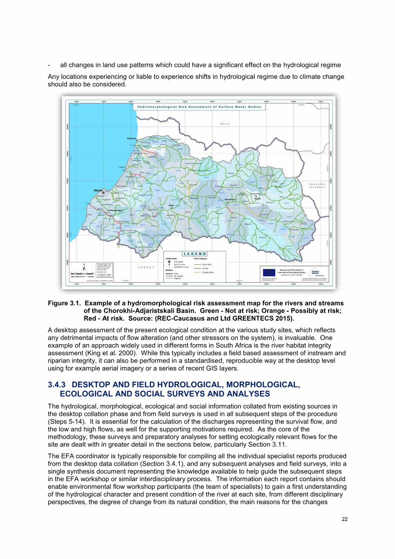
22
- all changes in land use patterns which could have a significant effect on the hydrological regime
Any locations experiencing or liable to experience shifts in hydrological regime due to climate change should also be considered.
Figure 3.1. Example of a hydromorphological risk assessment map for the rivers and streams of the Chorokhi-Adjaristskali Basin. Green - Not at risk; Orange - Possibly at risk; Red - At risk. Source: (REC-Caucasus and Ltd GREENTECS 2015).
A desktop assessment of the present ecological condition at the various study sites, which reflects any detrimental impacts of flow alteration (and other stressors on the system), is invaluable. One example of an approach widely used in different forms in South Africa is the river habitat integrity assessment (King et al. 2000). While this typically includes a field based assessment of instream and riparian integrity, it can also be performed in a standardised, reproducible way at the desktop level using for example aerial imagery or a series of recent GIS layers.
3.4.3 DESKTOP AND FIELD HYDROLOGICAL, MORPHOLOGICAL, ECOLOGICAL AND SOCIAL SURVEYS AND ANALYSES
The hydrological, morphological, ecological and social information collated from existing sources in the desktop collation phase and from field surveys is used in all subsequent steps of the procedure (Steps 5-14). It is essential for the calculation of the discharges representing the survival flow, and the low and high flows, as well for the supporting motivations required. As the core of the methodology, these surveys and preparatory analyses for setting ecologically relevant flows for the site are dealt with in greater detail in the sections below, particularly Section 3.11.
The EFA coordinator is typically responsible for compiling all the individual specialist reports produced from the desktop data collation (Section 3.4.1), and any subsequent analyses and field surveys, into a single synthesis document representing the knowledge available to help guide the subsequent steps in the EFA workshop or similar interdisciplinary process. The information each report contains should enable environmental flow workshop participants (the team of specialists) to gain a first understanding of the hydrological character and present condition of the river at each site, from different disciplinary perspectives, the degree of change from its natural condition, the main reasons for the changes
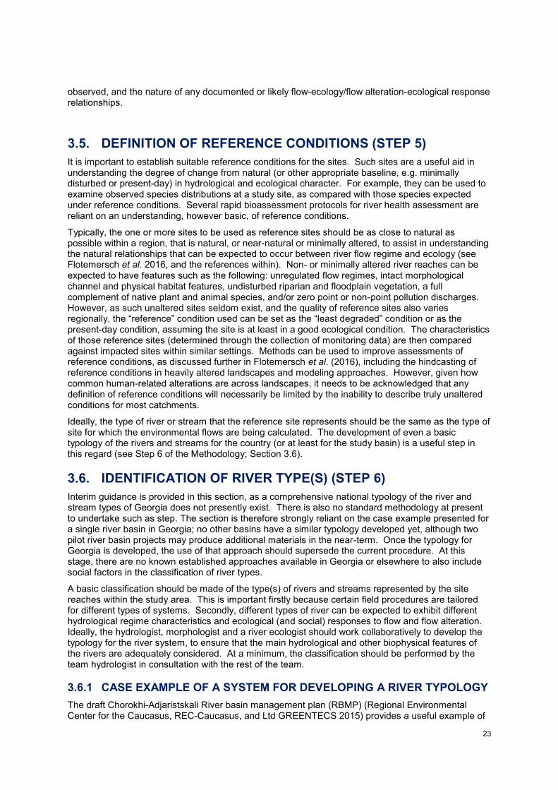
23
observed, and the nature of any documented or likely flow-ecology/flow alteration-ecological response relationships.
3.5. DEFINITION OF REFERENCE CONDITIONS (STEP 5)
It is important to establish suitable reference conditions for the sites. Such sites are a useful aid in understanding the degree of change from natural (or other appropriate baseline, e.g. minimally disturbed or present-day) in hydrological and ecological character. For example, they can be used to examine observed species distributions at a study site, as compared with those species expected under reference conditions. Several rapid bioassessment protocols for river health assessment are reliant on an understanding, however basic, of reference conditions.
Typically, the one or more sites to be used as reference sites should be as close to natural as possible within a region, that is natural, or near-natural or minimally altered, to assist in understanding the natural relationships that can be expected to occur between river flow regime and ecology (see Flotemersch et al. 2016, and the references within). Non- or minimally altered river reaches can be expected to have features such as the following: unregulated flow regimes, intact morphological channel and physical habitat features, undisturbed riparian and floodplain vegetation, a full complement of native plant and animal species, and/or zero point or non-point pollution discharges. However, as such unaltered sites seldom exist, and the quality of reference sites also varies regionally, the “reference” condition used can be set as the “least degraded” condition or as the present-day condition, assuming the site is at least in a good ecological condition. The characteristics of those reference sites (determined through the collection of monitoring data) are then compared against impacted sites within similar settings. Methods can be used to improve assessments of reference conditions, as discussed further in Flotemersch et al. (2016), including the hindcasting of reference conditions in heavily altered landscapes and modeling approaches. However, given how common human-related alterations are across landscapes, it needs to be acknowledged that any definition of reference conditions will necessarily be limited by the inability to describe truly unaltered conditions for most catchments.
Ideally, the type of river or stream that the reference site represents should be the same as the type of site for which the environmental flows are being calculated. The development of even a basic typology of the rivers and streams for the country (or at least for the study basin) is a useful step in this regard (see Step 6 of the Methodology; Section 3.6).
3.6. IDENTIFICATION OF RIVER TYPE(S) (STEP 6)
Interim guidance is provided in this section, as a comprehensive national typology of the river and stream types of Georgia does not presently exist. There is also no standard methodology at present to undertake such as step. The section is therefore strongly reliant on the case example presented for a single river basin in Georgia; no other basins have a similar typology developed yet, although two pilot river basin projects may produce additional materials in the near-term. Once the typology for Georgia is developed, the use of that approach should supersede the current procedure. At this stage, there are no known established approaches available in Georgia or elsewhere to also include social factors in the classification of river types.
A basic classification should be made of the type(s) of rivers and streams represented by the site reaches within the study area. This is important firstly because certain field procedures are tailored for different types of systems. Secondly, different types of river can be expected to exhibit different hydrological regime characteristics and ecological (and social) responses to flow and flow alteration. Ideally, the hydrologist, morphologist and a river ecologist should work collaboratively to develop the typology for the river system, to ensure that the main hydrological and other biophysical features of the rivers are adequately considered. At a minimum, the classification should be performed by the team hydrologist in consultation with the rest of the team.
3.6.1 CASE EXAMPLE OF A SYSTEM FOR DEVELOPING A RIVER TYPOLOGY
The draft Chorokhi-Adjaristskali River basin management plan (RBMP) (Regional Environmental Center for the Caucasus, REC-Caucasus, and Ltd GREENTECS 2015) provides a useful example of
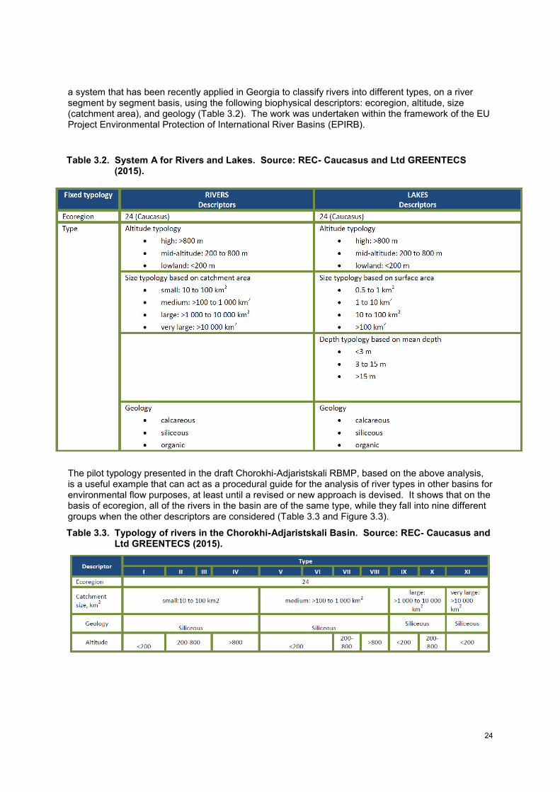
24
a system that has been recently applied in Georgia to classify rivers into different types, on a river segment by segment basis, using the following biophysical descriptors: ecoregion, altitude, size (catchment area), and geology (Table 3.2). The work was undertaken within the framework of the EU Project Environmental Protection of International River Basins (EPIRB).
Table 3.2. System A for Rivers and Lakes. Source: REC- Caucasus and Ltd GREENTECS (2015).
The pilot typology presented in the draft Chorokhi-Adjaristskali RBMP, based on the above analysis, is a useful example that can act as a procedural guide for the analysis of river types in other basins for environmental flow purposes, at least until a revised or new approach is devised. It shows that on the basis of ecoregion, all of the rivers in the basin are of the same type, while they fall into nine different groups when the other descriptors are considered (Table 3.3 and Figure 3.3).
Table 3.3. Typology of rivers in the Chorokhi-Adjaristskali Basin. Source: REC- Caucasus and Ltd GREENTECS (2015).
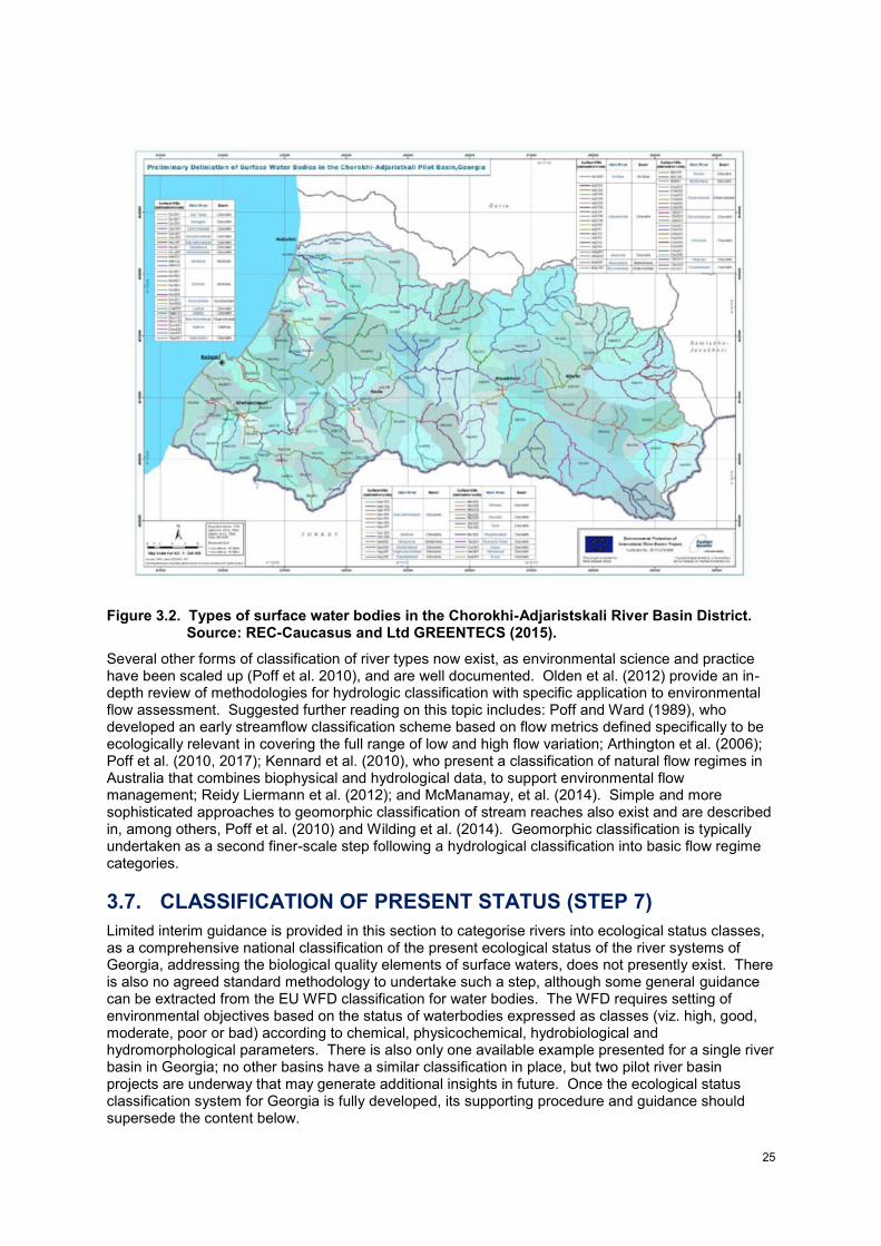
25
Figure 3.2. Types of surface water bodies in the Chorokhi-Adjaristskali River Basin District. Source: REC-Caucasus and Ltd GREENTECS (2015).
Several other forms of classification of river types now exist, as environmental science and practice have been scaled up (Poff et al. 2010), and are well documented. Olden et al. (2012) provide an in-depth review of methodologies for hydrologic classification with specific application to environmental flow assessment. Suggested further reading on this topic includes: Poff and Ward (1989), who developed an early streamflow classification scheme based on flow metrics defined specifically to be ecologically relevant in covering the full range of low and high flow variation; Arthington et al. (2006); Poff et al. (2010, 2017); Kennard et al. (2010), who present a classification of natural flow regimes in Australia that combines biophysical and hydrological data, to support environmental flow management; Reidy Liermann et al. (2012); and McManamay, et al. (2014). Simple and more sophisticated approaches to geomorphic classification of stream reaches also exist and are described in, among others, Poff et al. (2010) and Wilding et al. (2014). Geomorphic classification is typically undertaken as a second finer-scale step following a hydrological classification into basic flow regime categories.
3.7. CLASSIFICATION OF PRESENT STATUS (STEP 7)
Limited interim guidance is provided in this section to categorise rivers into ecological status classes, as a comprehensive national classification of the present ecological status of the river systems of Georgia, addressing the biological quality elements of surface waters, does not presently exist. There is also no agreed standard methodology to undertake such a step, although some general guidance can be extracted from the EU WFD classification for water bodies. The WFD requires setting of environmental objectives based on the status of waterbodies expressed as classes (viz. high, good, moderate, poor or bad) according to chemical, physicochemical, hydrobiological and hydromorphological parameters. There is also only one available example presented for a single river basin in Georgia; no other basins have a similar classification in place, but two pilot river basin projects are underway that may generate additional insights in future. Once the ecological status classification system for Georgia is fully developed, its supporting procedure and guidance should supersede the content below.
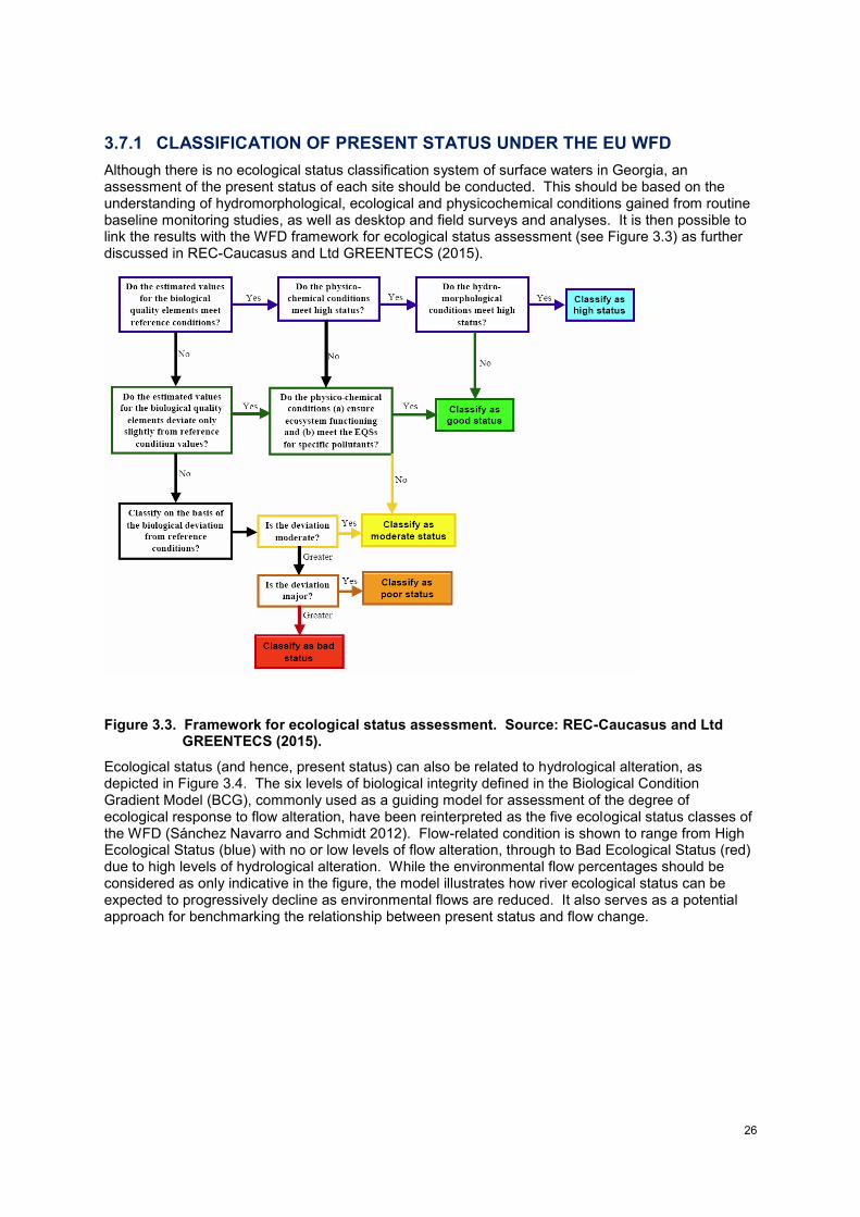
26
3.7.1 CLASSIFICATION OF PRESENT STATUS UNDER THE EU WFD
Although there is no ecological status classification system of surface waters in Georgia, an assessment of the present status of each site should be conducted. This should be based on the understanding of hydromorphological, ecological and physicochemical conditions gained from routine baseline monitoring studies, as well as desktop and field surveys and analyses. It is then possible to link the results with the WFD framework for ecological status assessment (see Figure 3.3) as further discussed in REC-Caucasus and Ltd GREENTECS (2015).
Figure 3.3. Framework for ecological status assessment. Source: REC-Caucasus and Ltd GREENTECS (2015).
Ecological status (and hence, present status) can also be related to hydrological alteration, as depicted in Figure 3.4. The six levels of biological integrity defined in the Biological Condition Gradient Model (BCG), commonly used as a guiding model for assessment of the degree of ecological response to flow alteration, have been reinterpreted as the five ecological status classes of the WFD (Sánchez Navarro and Schmidt 2012). Flow-related condition is shown to range from High Ecological Status (blue) with no or low levels of flow alteration, through to Bad Ecological Status (red) due to high levels of hydrological alteration. While the environmental flow percentages should be considered as only indicative in the figure, the model illustrates how river ecological status can be expected to progressively decline as environmental flows are reduced. It also serves as a potential approach for benchmarking the relationship between present status and flow change.
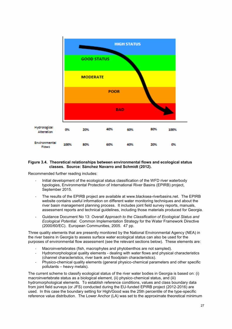
27
Figure 3.4. Theoretical relationships between environmental flows and ecological status classes. Source: Sánchez Navarro and Schmidt (2012).
Recommended further reading includes:
- Initial development of the ecological status classification of the WFD river waterbody typologies, Environmental Protection of International River Basins (EPIRB) project, September 2015.
- The results of the EPIRB project are available at www.blacksea-riverbasins.net. The EPIRB website contains useful information on different water monitoring techniques and about the river basin management planning process. It includes joint field survey reports, manuals, assessment reports and technical guidelines, including those materials produced for Georgia.
- Guidance Document No 13: Overall Approach to the Classification of Ecological Status and Ecological Potential. Common Implementation Strategy for the Water Framework Directive (2000/60/EC). European Communities, 2005. 47 pp.
Three quality elements that are presently monitored by the National Environmental Agency (NEA) in the river basins in Georgia to assess surface water ecological status can also be used for the purposes of environmental flow assessment (see the relevant sections below). These elements are:
- Macroinvertebrates (fish, macrophytes and phytobenthos are not sampled). - Hydromorphological quality elements - dealing with water flows and physical characteristics
(channel characteristics, river bank and floodplain characteristics).
- Physico-chemical quality elements (general physico-chemical parameters and other specific pollutants – heavy metals).
The current scheme to classify ecological status of the river water bodies in Georgia is based on: (i) macroinvertebrate status as a biological element, (ii) physico-chemical status, and (iii) hydromorphological elements. To establish reference conditions, values and class boundary data from joint field surveys (or JFS) conducted during the EU-funded EPIRB project (2012-2016) are used. In this case the boundary setting for High/Good was the 25th percentile of the type-specific reference value distribution. The Lower Anchor (LA) was set to the approximate theoretical minimum
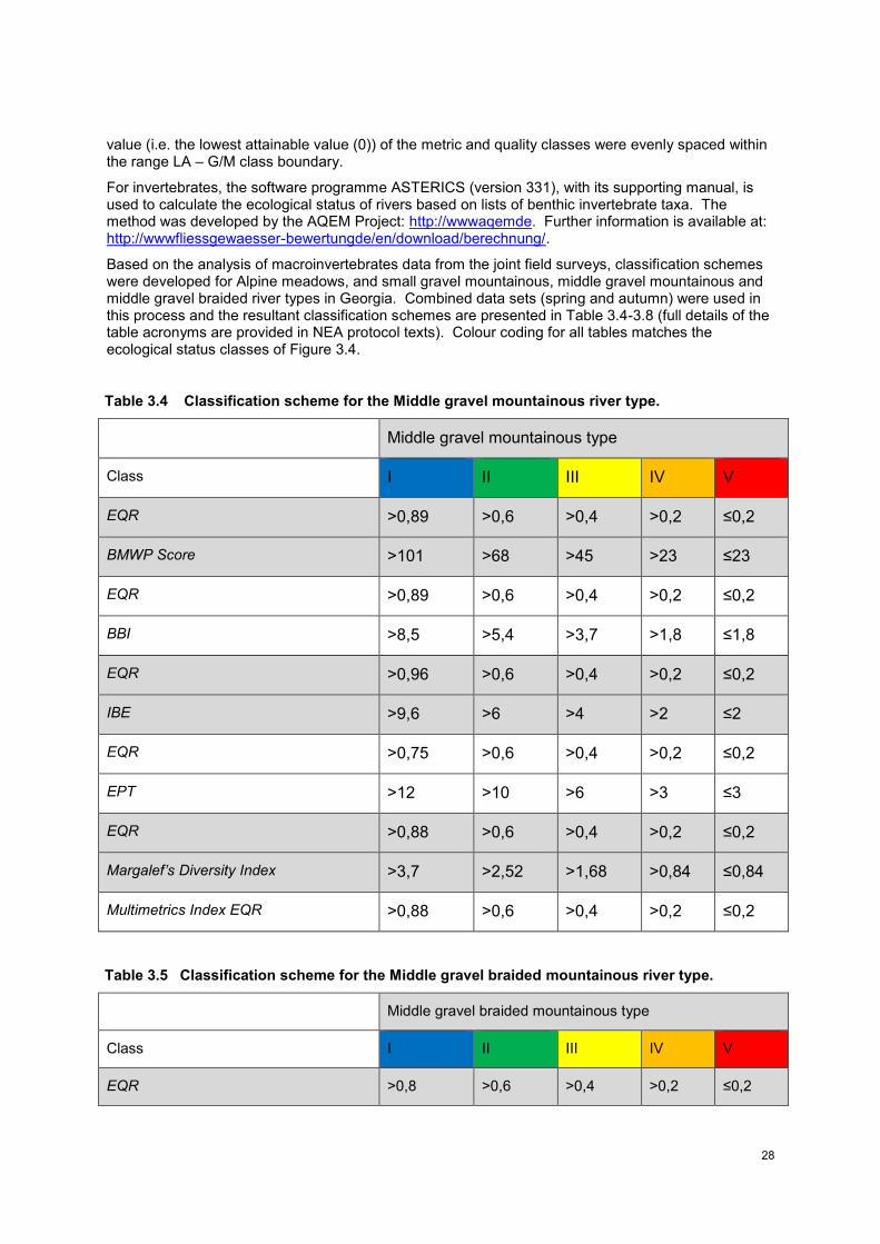
28
value (i.e. the lowest attainable value (0)) of the metric and quality classes were evenly spaced within the range LA – G/M class boundary.
For invertebrates, the software programme ASTERICS (version 331), with its supporting manual, is used to calculate the ecological status of rivers based on lists of benthic invertebrate taxa. The method was developed by the AQEM Project: http://wwwaqemde. Further information is available at: http://wwwfliessgewaesser-bewertungde/en/download/berechnung/.
Based on the analysis of macroinvertebrates data from the joint field surveys, classification schemes were developed for Alpine meadows, and small gravel mountainous, middle gravel mountainous and middle gravel braided river types in Georgia. Combined data sets (spring and autumn) were used in this process and the resultant classification schemes are presented in Table 3.4-3.8 (full details of the table acronyms are provided in NEA protocol texts). Colour coding for all tables matches the ecological status classes of Figure 3.4.
Table 3.4 Classification scheme for the Middle gravel mountainous river type.
Middle gravel mountainous type
Class I II III IV V
EQR >0,89 >0,6 >0,4 >0,2 ≤0,2
BMWP Score >101 >68 >45 >23 ≤23
EQR >0,89 >0,6 >0,4 >0,2 ≤0,2
BBI >8,5 >5,4 >3,7 >1,8 ≤1,8
EQR >0,96 >0,6 >0,4 >0,2 ≤0,2
IBE >9,6 >6 >4 >2 ≤2
EQR >0,75 >0,6 >0,4 >0,2 ≤0,2
EPT >12 >10 >6 >3 ≤3
EQR >0,88 >0,6 >0,4 >0,2 ≤0,2
Margalef’s Diversity Index >3,7 >2,52 >1,68 >0,84 ≤0,84
Multimetrics Index EQR >0,88 >0,6 >0,4 >0,2 ≤0,2
Table 3.5 Classification scheme for the Middle gravel braided mountainous river type.
Middle gravel braided mountainous type
Class I II III IV V
EQR >0,8 >0,6 >0,4 >0,2 ≤0,2
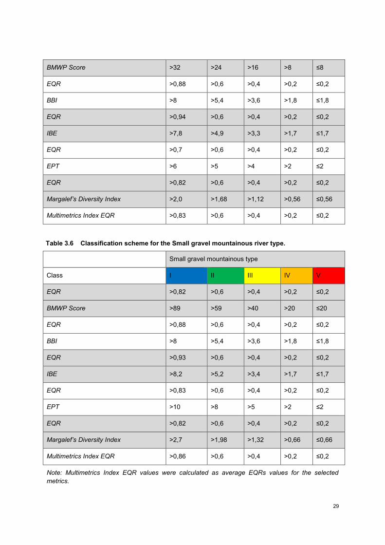
29
BMWP Score >32 >24 >16 >8 ≤8
EQR >0,88 >0,6 >0,4 >0,2 ≤0,2
BBI >8 >5,4 >3,6 >1,8 ≤1,8
EQR >0,94 >0,6 >0,4 >0,2 ≤0,2
IBE >7,8 >4,9 >3,3 >1,7 ≤1,7
EQR >0,7 >0,6 >0,4 >0,2 ≤0,2
EPT >6 >5 >4 >2 ≤2
EQR >0,82 >0,6 >0,4 >0,2 ≤0,2
Margalef’s Diversity Index >2,0 >1,68 >1,12 >0,56 ≤0,56
Multimetrics Index EQR >0,83 >0,6 >0,4 >0,2 ≤0,2
Table 3.6 Classification scheme for the Small gravel mountainous river type.
Small gravel mountainous type
Class I II III IV V
EQR >0,82 >0,6 >0,4 >0,2 ≤0,2
BMWP Score >89 >59 >40 >20 ≤20
EQR >0,88 >0,6 >0,4 >0,2 ≤0,2
BBI >8 >5,4 >3,6 >1,8 ≤1,8
EQR >0,93 >0,6 >0,4 >0,2 ≤0,2
IBE >8,2 >5,2 >3,4 >1,7 ≤1,7
EQR >0,83 >0,6 >0,4 >0,2 ≤0,2
EPT >10 >8 >5 >2 ≤2
EQR >0,82 >0,6 >0,4 >0,2 ≤0,2
Margalef’s Diversity Index >2,7 >1,98 >1,32 >0,66 ≤0,66
Multimetrics Index EQR >0,86 >0,6 >0,4 >0,2 ≤0,2
Note: Multimetrics Index EQR values were calculated as average EQRs values for the selected
metrics.
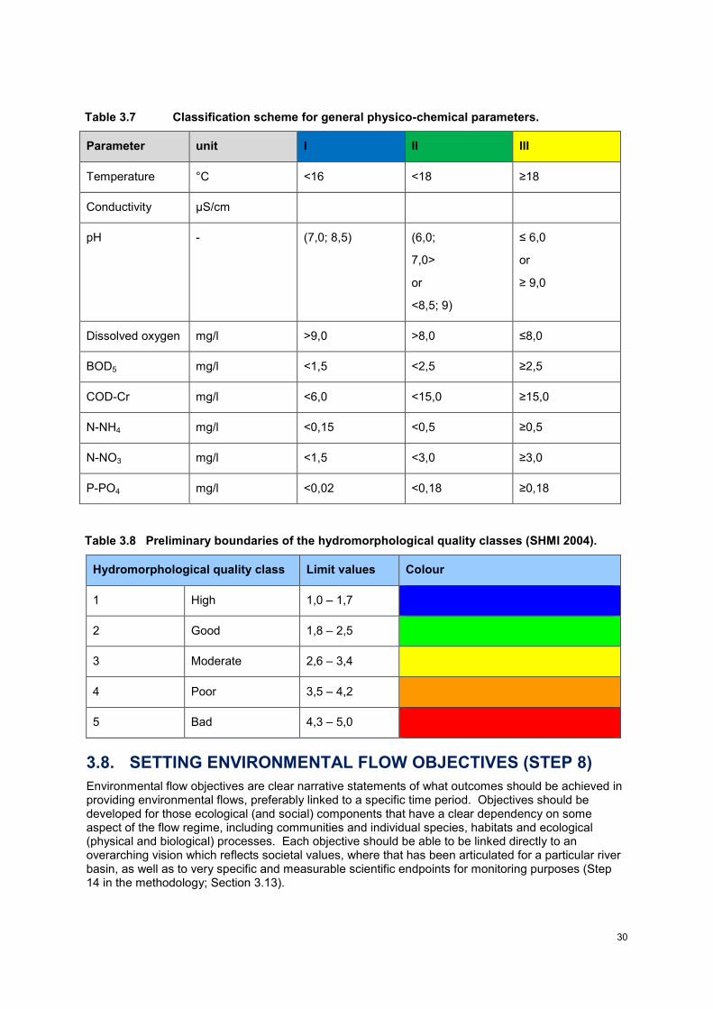
30
Table 3.7 Classification scheme for general physico-chemical parameters.
Parameter unit I II III
Temperature °C <16 <18 ≥18
Conductivity µS/cm
pH - (7,0; 8,5) (6,0;
7,0>
or
<8,5; 9)
≤ 6,0
or
≥ 9,0
Dissolved oxygen mg/l >9,0 >8,0 ≤8,0
BOD5 mg/l <1,5 <2,5 ≥2,5
COD-Cr mg/l <6,0 <15,0 ≥15,0
N-NH4 mg/l <0,15 <0,5 ≥0,5
N-NO3 mg/l <1,5 <3,0 ≥3,0
P-PO4 mg/l <0,02 <0,18 ≥0,18
Table 3.8 Preliminary boundaries of the hydromorphological quality classes (SHMI 2004).
Hydromorphological quality class Limit values Colour
1 High 1,0 – 1,7
2 Good 1,8 – 2,5
3 Moderate 2,6 – 3,4
4 Poor 3,5 – 4,2
5 Bad 4,3 – 5,0
3.8. SETTING ENVIRONMENTAL FLOW OBJECTIVES (STEP 8)
Environmental flow objectives are clear narrative statements of what outcomes should be achieved in providing environmental flows, preferably linked to a specific time period. Objectives should be developed for those ecological (and social) components that have a clear dependency on some aspect of the flow regime, including communities and individual species, habitats and ecological (physical and biological) processes. Each objective should be able to be linked directly to an overarching vision which reflects societal values, where that has been articulated for a particular river basin, as well as to very specific and measurable scientific endpoints for monitoring purposes (Step 14 in the methodology; Section 3.13).
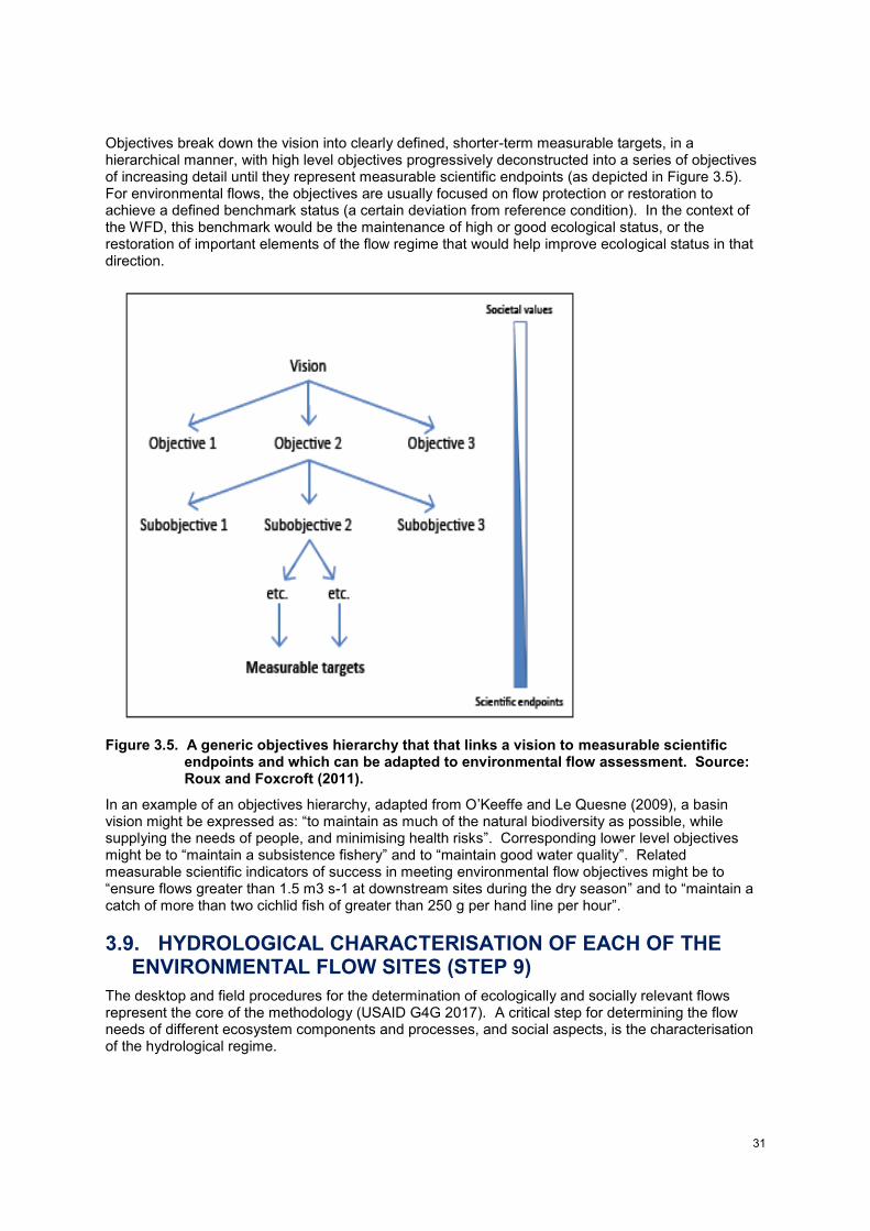
31
Objectives break down the vision into clearly defined, shorter-term measurable targets, in a hierarchical manner, with high level objectives progressively deconstructed into a series of objectives of increasing detail until they represent measurable scientific endpoints (as depicted in Figure 3.5). For environmental flows, the objectives are usually focused on flow protection or restoration to achieve a defined benchmark status (a certain deviation from reference condition). In the context of the WFD, this benchmark would be the maintenance of high or good ecological status, or the restoration of important elements of the flow regime that would help improve ecological status in that direction.
Figure 3.5. A generic objectives hierarchy that that links a vision to measurable scientific endpoints and which can be adapted to environmental flow assessment. Source: Roux and Foxcroft (2011).
In an example of an objectives hierarchy, adapted from O’Keeffe and Le Quesne (2009), a basin vision might be expressed as: “to maintain as much of the natural biodiversity as possible, while supplying the needs of people, and minimising health risks”. Corresponding lower level objectives might be to “maintain a subsistence fishery” and to “maintain good water quality”. Related measurable scientific indicators of success in meeting environmental flow objectives might be to “ensure flows greater than 1.5 m3 s-1 at downstream sites during the dry season” and to “maintain a catch of more than two cichlid fish of greater than 250 g per hand line per hour”.
3.9. HYDROLOGICAL CHARACTERISATION OF EACH OF THE ENVIRONMENTAL FLOW SITES (STEP 9)
The desktop and field procedures for the determination of ecologically and socially relevant flows represent the core of the methodology (USAID G4G 2017). A critical step for determining the flow needs of different ecosystem components and processes, and social aspects, is the characterisation of the hydrological regime.
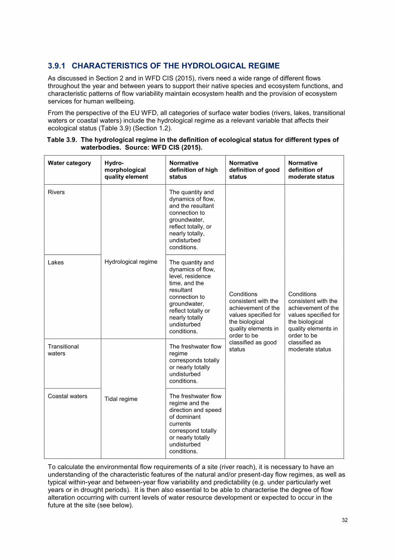
32
3.9.1 CHARACTERISTICS OF THE HYDROLOGICAL REGIME
As discussed in Section 2 and in WFD CIS (2015), rivers need a wide range of different flows throughout the year and between years to support their native species and ecosystem functions, and characteristic patterns of flow variability maintain ecosystem health and the provision of ecosystem services for human wellbeing.
From the perspective of the EU WFD, all categories of surface water bodies (rivers, lakes, transitional waters or coastal waters) include the hydrological regime as a relevant variable that affects their ecological status (Table 3.9) (Section 1.2).
Table 3.9. The hydrological regime in the definition of ecological status for different types of waterbodies. Source: WFD CIS (2015).
Water category Hydro-morphological quality element
Normative definition of high status
Normative definition of good status
Normative definition of moderate status
Rivers
Hydrological regime
The quantity and dynamics of flow, and the resultant connection to groundwater, reflect totally, or nearly totally, undisturbed conditions.
Conditions consistent with the achievement of the values specified for the biological quality elements in order to be classified as good status
Conditions consistent with the achievement of the values specified for the biological quality elements in order to be classified as moderate status
Lakes The quantity and dynamics of flow, level, residence time, and the resultant connection to groundwater, reflect totally or nearly totally undisturbed conditions.
Transitional waters
Tidal regime
The freshwater flow regime corresponds totally or nearly totally undisturbed conditions.
Coastal waters The freshwater flow regime and the direction and speed of dominant currents correspond totally or nearly totally undisturbed conditions.
To calculate the environmental flow requirements of a site (river reach), it is necessary to have an understanding of the characteristic features of the natural and/or present-day flow regimes, as well as typical within-year and between-year flow variability and predictability (e.g. under particularly wet years or in drought periods). It is then also essential to be able to characterise the degree of flow alteration occurring with current levels of water resource development or expected to occur in the future at the site (see below).
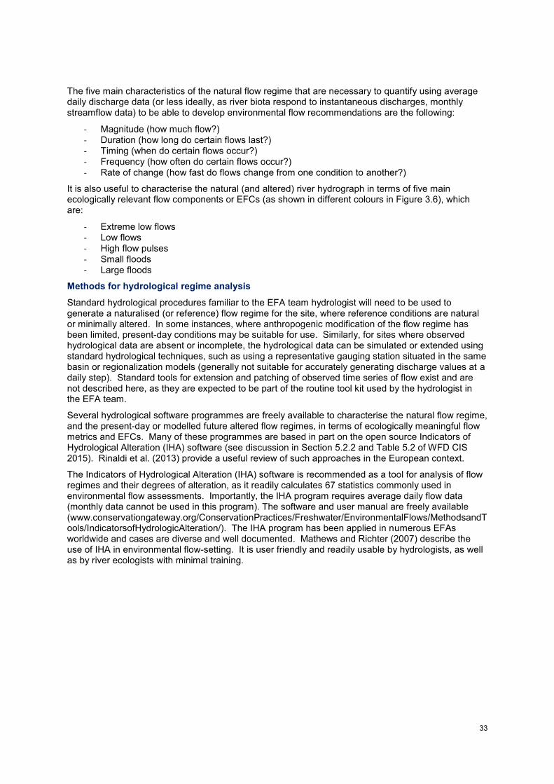
33
The five main characteristics of the natural flow regime that are necessary to quantify using average daily discharge data (or less ideally, as river biota respond to instantaneous discharges, monthly streamflow data) to be able to develop environmental flow recommendations are the following:
- Magnitude (how much flow?) - Duration (how long do certain flows last?) - Timing (when do certain flows occur?) - Frequency (how often do certain flows occur?) - Rate of change (how fast do flows change from one condition to another?)
It is also useful to characterise the natural (and altered) river hydrograph in terms of five main ecologically relevant flow components or EFCs (as shown in different colours in Figure 3.6), which are:
- Extreme low flows - Low flows - High flow pulses - Small floods - Large floods
Methods for hydrological regime analysis
Standard hydrological procedures familiar to the EFA team hydrologist will need to be used to generate a naturalised (or reference) flow regime for the site, where reference conditions are natural or minimally altered. In some instances, where anthropogenic modification of the flow regime has been limited, present-day conditions may be suitable for use. Similarly, for sites where observed hydrological data are absent or incomplete, the hydrological data can be simulated or extended using standard hydrological techniques, such as using a representative gauging station situated in the same basin or regionalization models (generally not suitable for accurately generating discharge values at a daily step). Standard tools for extension and patching of observed time series of flow exist and are not described here, as they are expected to be part of the routine tool kit used by the hydrologist in the EFA team.
Several hydrological software programmes are freely available to characterise the natural flow regime, and the present-day or modelled future altered flow regimes, in terms of ecologically meaningful flow metrics and EFCs. Many of these programmes are based in part on the open source Indicators of Hydrological Alteration (IHA) software (see discussion in Section 5.2.2 and Table 5.2 of WFD CIS 2015). Rinaldi et al. (2013) provide a useful review of such approaches in the European context.
The Indicators of Hydrological Alteration (IHA) software is recommended as a tool for analysis of flow regimes and their degrees of alteration, as it readily calculates 67 statistics commonly used in environmental flow assessments. Importantly, the IHA program requires average daily flow data (monthly data cannot be used in this program). The software and user manual are freely available (www.conservationgateway.org/ConservationPractices/Freshwater/EnvironmentalFlows/MethodsandTools/IndicatorsofHydrologicAlteration/). The IHA program has been applied in numerous EFAs worldwide and cases are diverse and well documented. Mathews and Richter (2007) describe the use of IHA in environmental flow-setting. It is user friendly and readily usable by hydrologists, as well as by river ecologists with minimal training.
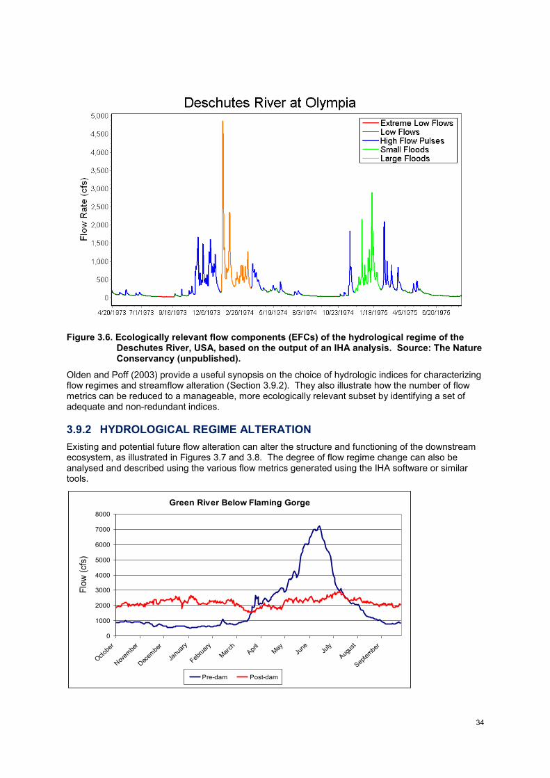
34
Figure 3.6. Ecologically relevant flow components (EFCs) of the hydrological regime of the Deschutes River, USA, based on the output of an IHA analysis. Source: The Nature Conservancy (unpublished).
Olden and Poff (2003) provide a useful synopsis on the choice of hydrologic indices for characterizing flow regimes and streamflow alteration (Section 3.9.2). They also illustrate how the number of flow metrics can be reduced to a manageable, more ecologically relevant subset by identifying a set of adequate and non-redundant indices.
3.9.2 HYDROLOGICAL REGIME ALTERATION
Existing and potential future flow alteration can alter the structure and functioning of the downstream ecosystem, as illustrated in Figures 3.7 and 3.8. The degree of flow regime change can also be analysed and described using the various flow metrics generated using the IHA software or similar tools.
Green River Below Flaming Gorge
0
1000
2000
3000
4000
5000
6000
7000
8000
Oct
ober
Nov
embe
r
Dec
embe
r
Janu
ary
Febru
ary
Mar
chApr
ilM
ayJu
neJu
ly
Aug
ust
Sep
tem
ber
Flo
w (
cfs
)
Pre-dam Post-dam
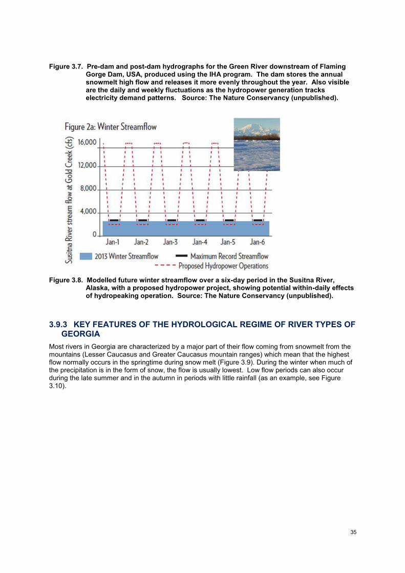
35
Figure 3.7. Pre-dam and post-dam hydrographs for the Green River downstream of Flaming Gorge Dam, USA, produced using the IHA program. The dam stores the annual snowmelt high flow and releases it more evenly throughout the year. Also visible are the daily and weekly fluctuations as the hydropower generation tracks electricity demand patterns. Source: The Nature Conservancy (unpublished).
Figure 3.8. Modelled future winter streamflow over a six-day period in the Susitna River, Alaska, with a proposed hydropower project, showing potential within-daily effects of hydropeaking operation. Source: The Nature Conservancy (unpublished).
3.9.3 KEY FEATURES OF THE HYDROLOGICAL REGIME OF RIVER TYPES OF GEORGIA
Most rivers in Georgia are characterized by a major part of their flow coming from snowmelt from the mountains (Lesser Caucasus and Greater Caucasus mountain ranges) which mean that the highest flow normally occurs in the springtime during snow melt (Figure 3.9). During the winter when much of the precipitation is in the form of snow, the flow is usually lowest. Low flow periods can also occur during the late summer and in the autumn in periods with little rainfall (as an example, see Figure 3.10).
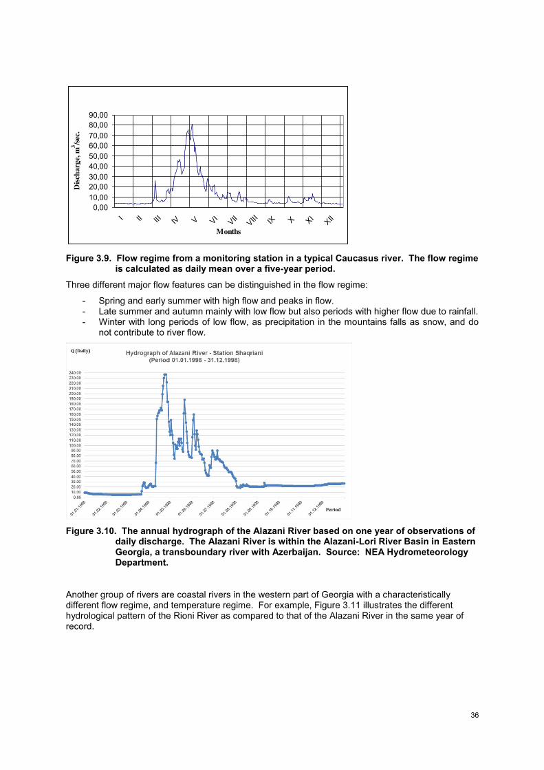
36
Figure 3.9. Flow regime from a monitoring station in a typical Caucasus river. The flow regime is calculated as daily mean over a five-year period.
Three different major flow features can be distinguished in the flow regime:
- Spring and early summer with high flow and peaks in flow. - Late summer and autumn mainly with low flow but also periods with higher flow due to rainfall. - Winter with long periods of low flow, as precipitation in the mountains falls as snow, and do
not contribute to river flow.
Figure 3.10. The annual hydrograph of the Alazani River based on one year of observations of daily discharge. The Alazani River is within the Alazani-Lori River Basin in Eastern Georgia, a transboundary river with Azerbaijan. Source: NEA Hydrometeorology Department.
Another group of rivers are coastal rivers in the western part of Georgia with a characteristically different flow regime, and temperature regime. For example, Figure 3.11 illustrates the different hydrological pattern of the Rioni River as compared to that of the Alazani River in the same year of record.
0,00
10,00
20,00
30,00
40,00
50,00
60,00
70,00
80,00
90,00
I II III IV V VI
VII
VIII IX X X
IXII
Months
Dis
cha
rge,
m3/s
ec.
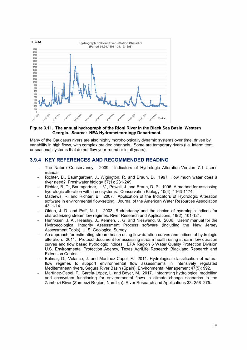
37
Figure 3.11. The annual hydrograph of the Rioni River in the Black Sea Basin, Western Georgia. Source: NEA Hydrometeorology Department.
Many of the Caucasus rivers are also highly morphologically dynamic systems over time, driven by variability in high flows, with complex braided channels. Some are temporary rivers (i.e. intermittent or seasonal systems that do not flow year-round or in all years).
3.9.4 KEY REFERENCES AND RECOMMENDED READING
- The Nature Conservancy. 2009. Indicators of Hydrologic Alteration-Version 7.1 User’s manual.
- Richter, B., Baumgartner, J., Wigington, R. and Braun, D. 1997. How much water does a river need? Freshwater biology 37(1): 231-249.
- Richter, B. D., Baumgartner, J. V., Powell, J. and Braun, D. P. 1996. A method for assessing hydrologic alteration within ecosystems. Conservation Biology 10(4): 1163-1174.
- Mathews, R. and Richter, B. 2007. Application of the Indicators of Hydrologic Alteration software in environmental flow-setting. Journal of the American Water Resources Association 43: 1-14.
- Olden, J. D. and Poff, N. L. 2003. Redundancy and the choice of hydrologic indices for characterizing streamflow regimes. River Research and Applications, 19(2): 101-121.
- Henriksen, J. A., Heasley, J., Kennen, J. G. and Nieswand, S. 2006. Users' manual for the Hydroecological Integrity Assessment Process software (including the New Jersey Assessment Tools). U. S. Geological Survey.
- An approach for estimating stream health using flow duration curves and indices of hydrologic alteration. 2011. Protocol document for assessing stream health using stream flow duration curves and flow based hydrologic indices. EPA Region 6 Water Quality Protection Division U.S. Environmental Protection Agency, Texas AgriLife Research Blackland Research and Extension Center.
- Belmar, O., Velasco, J. and Martinez-Capel, F. 2011. Hydrological classification of natural flow regimes to support environmental flow assessments in intensively regulated Mediterranean rivers, Segura River Basin (Spain). Environmental Management 47(5): 992.
- Martínez‐Capel, F., García‐López, L. and Beyer, M. 2017. Integrating hydrological modelling and ecosystem functioning for environmental flows in climate change scenarios in the Zambezi River (Zambezi Region, Namibia). River Research and Applications 33: 258–275.
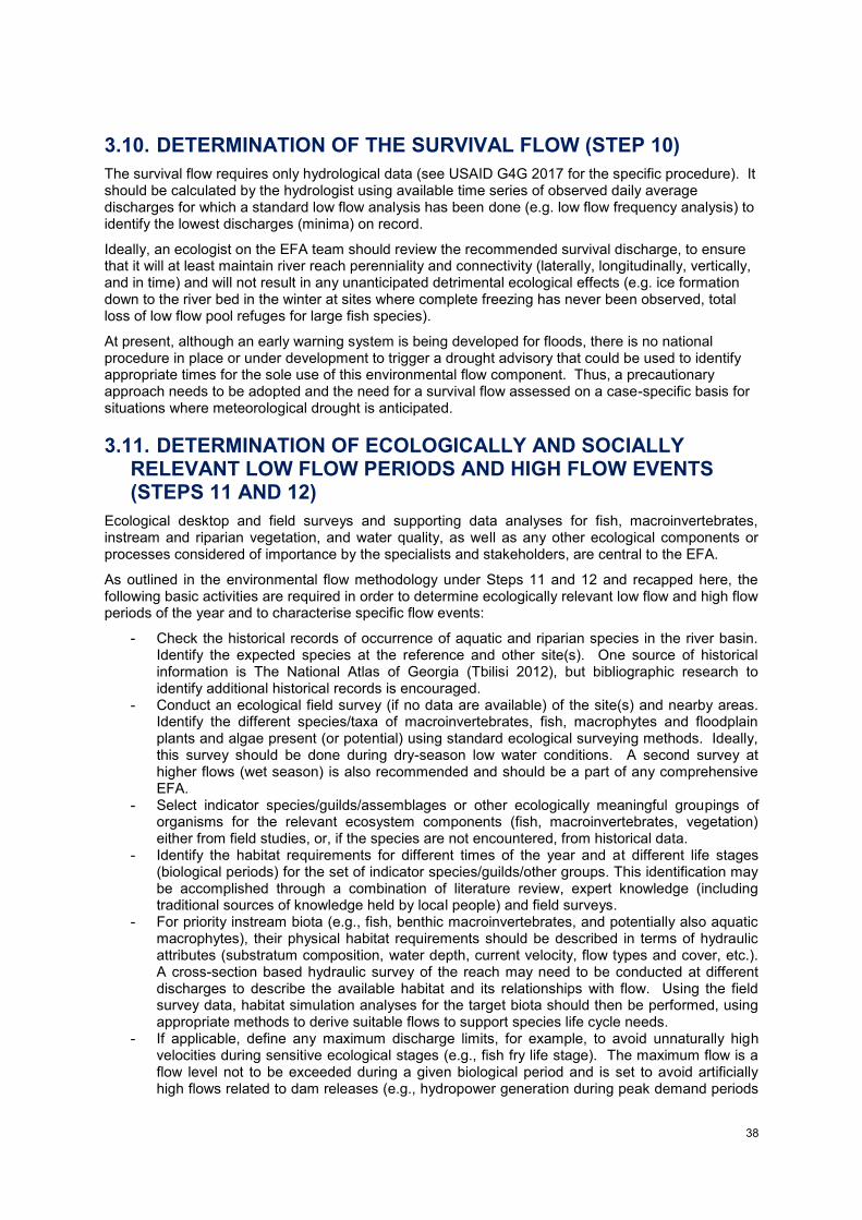
38
3.10. DETERMINATION OF THE SURVIVAL FLOW (STEP 10)
The survival flow requires only hydrological data (see USAID G4G 2017 for the specific procedure). It should be calculated by the hydrologist using available time series of observed daily average discharges for which a standard low flow analysis has been done (e.g. low flow frequency analysis) to identify the lowest discharges (minima) on record.
Ideally, an ecologist on the EFA team should review the recommended survival discharge, to ensure that it will at least maintain river reach perenniality and connectivity (laterally, longitudinally, vertically, and in time) and will not result in any unanticipated detrimental ecological effects (e.g. ice formation down to the river bed in the winter at sites where complete freezing has never been observed, total loss of low flow pool refuges for large fish species).
At present, although an early warning system is being developed for floods, there is no national procedure in place or under development to trigger a drought advisory that could be used to identify appropriate times for the sole use of this environmental flow component. Thus, a precautionary approach needs to be adopted and the need for a survival flow assessed on a case-specific basis for situations where meteorological drought is anticipated.
3.11. DETERMINATION OF ECOLOGICALLY AND SOCIALLY RELEVANT LOW FLOW PERIODS AND HIGH FLOW EVENTS (STEPS 11 AND 12)
Ecological desktop and field surveys and supporting data analyses for fish, macroinvertebrates, instream and riparian vegetation, and water quality, as well as any other ecological components or processes considered of importance by the specialists and stakeholders, are central to the EFA.
As outlined in the environmental flow methodology under Steps 11 and 12 and recapped here, the following basic activities are required in order to determine ecologically relevant low flow and high flow periods of the year and to characterise specific flow events:
- Check the historical records of occurrence of aquatic and riparian species in the river basin. Identify the expected species at the reference and other site(s). One source of historical information is The National Atlas of Georgia (Tbilisi 2012), but bibliographic research to identify additional historical records is encouraged.
- Conduct an ecological field survey (if no data are available) of the site(s) and nearby areas. Identify the different species/taxa of macroinvertebrates, fish, macrophytes and floodplain plants and algae present (or potential) using standard ecological surveying methods. Ideally, this survey should be done during dry-season low water conditions. A second survey at higher flows (wet season) is also recommended and should be a part of any comprehensive EFA.
- Select indicator species/guilds/assemblages or other ecologically meaningful groupings of organisms for the relevant ecosystem components (fish, macroinvertebrates, vegetation) either from field studies, or, if the species are not encountered, from historical data.
- Identify the habitat requirements for different times of the year and at different life stages (biological periods) for the set of indicator species/guilds/other groups. This identification may be accomplished through a combination of literature review, expert knowledge (including traditional sources of knowledge held by local people) and field surveys.
- For priority instream biota (e.g., fish, benthic macroinvertebrates, and potentially also aquatic macrophytes), their physical habitat requirements should be described in terms of hydraulic attributes (substratum composition, water depth, current velocity, flow types and cover, etc.). A cross-section based hydraulic survey of the reach may need to be conducted at different discharges to describe the available habitat and its relationships with flow. Using the field survey data, habitat simulation analyses for the target biota should then be performed, using appropriate methods to derive suitable flows to support species life cycle needs.
- If applicable, define any maximum discharge limits, for example, to avoid unnaturally high velocities during sensitive ecological stages (e.g., fish fry life stage). The maximum flow is a flow level not to be exceeded during a given biological period and is set to avoid artificially high flows related to dam releases (e.g., hydropower generation during peak demand periods
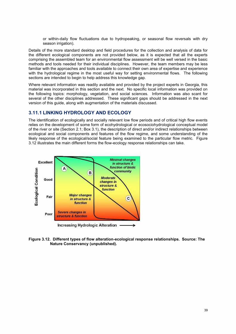
39
or within-daily flow fluctuations due to hydropeaking, or seasonal flow reversals with dry season irrigation).
Details of the more standard desktop and field procedures for the collection and analysis of data for the different ecological components are not provided below, as it is expected that all the experts comprising the assembled team for an environmental flow assessment will be well versed in the basic methods and tools needed for their individual disciplines. However, the team members may be less familiar with the approaches and tools available to connect their own area of expertise and experience with the hydrological regime in the most useful way for setting environmental flows. The following sections are intended to begin to help address this knowledge gap.
Where relevant information was readily available and provided by the project experts in Georgia, this material was incorporated in this section and the next. No specific local information was provided on the following topics: morphology, vegetation, and social sciences. Information was also scant for several of the other disciplines addressed. These significant gaps should be addressed in the next version of this guide, along with augmentation of the materials discussed.
3.11.1 LINKING HYDROLOGY AND ECOLOGY
The identification of ecologically and socially relevant low flow periods and of critical high flow events relies on the development of some form of ecohydrological or ecosociohydrological conceptual model of the river or site (Section 2.1; Box 3.1), the description of direct and/or indirect relationships between ecological and social components and features of the flow regime, and some understanding of the likely response of the ecological/social feature being examined to the particular flow metric. Figure 3.12 illustrates the main different forms the flow-ecology response relationships can take.
Figure 3.12. Different types of flow alteration-ecological response relationships. Source: The Nature Conservancy (unpublished).
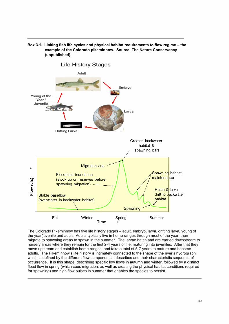
40
Box 3.1. Linking fish life cycles and physical habitat requirements to flow regime – the
example of the Colorado pikeminnow. Source: The Nature Conservancy
(unpublished).
The Colorado Pikeminnow has five life history stages – adult, embryo, larva, drifting larva, young of the year/juvenile and adult. Adults typically live in home ranges through most of the year, then migrate to spawning areas to spawn in the summer. The larvae hatch and are carried downstream to nursery areas where they remain for the first 2-4 years of life, maturing into juveniles. After that they move upstream and establish home ranges, and take a total of 5-7 years to mature and become adults. The Pikeminnow’s life history is intimately connected to the shape of the river’s hydrograph which is defined by the different flow components it describes and their characteristic sequence of occurrence. It is this shape, describing specific low flows in autumn and winter, followed by a distinct flood flow in spring (which cues migration, as well as creating the physical habitat conditions required for spawning) and high flow pulses in summer that enables the species to persist.
41
For each recommended low and high flow, ecological (and social) motivations should be documented, and these should be as specific as possible. The implications of not providing the specific flow level should also be articulated. This helps ensure that the recommended values for discharge magnitude will (to the best knowledge of the EFA experts) ensure good ecological status is achievable or can be maintained at the site, and that no deterioration to a lower status will occur. The level of confidence in each individual motivation provided for the different components of the environmental flow regime should also be provided, as at least a three-level rating scale: Low, Moderate or High. Any major areas of uncertainty should be highlighted, as should any fundamental data (and hence, research) gaps.
Some basic criteria can be applied for the selection of hydrological (flow) variables, for the establishment of flow-ecological response relationships, and at a later stage, for monitoring of the environmental flows (Section 3.13). The selected hydrological indicators should be strongly linked to ecological condition and be amenable for use as water management targets. Examples might include: the timing of flood peaks; the duration of an extreme low/zero-flow period; and the percent of flow diverted in the known lowest flow month.
Similarly, ecological indicators must be able to be validated with monitoring data. Ecological parameters should be as mechanistically linked to particular flow regime components as possible or exhibit some form of process-based relationship, so that they are sufficiently sensitive to one or more aspects of existing or proposed flow alteration (Poff et al. 2010). Flow alteration-ecological response relationships can be compiled from existing or new data and then tested statistically to determine the form (e.g. linear or threshold; Figure 3.12) and degree of ecological change (positive or negative) associated with a particular type of flow regime alteration (Arthington et al. 2006). Where feasible, the indicators or metrics of response should also be valued by society. Examples are: aquatic invertebrate species richness; riparian vegetation recruitment; and larval fish abundance. Data can be indirectly related to biological condition. Examples include geomorphic condition and water quality (dissolved oxygen, temperature). Social indicators linked to flow regime may include, for instance, provisioning services such as fisheries catch data or measures reflecting water-related cultural heritage or amenity and recreation value for tourism.
A recent comprehensive overview of models of ecological responses to flow regime change that can be used to inform EFAs is provided in Webb et al. (2017). Poff et al. (2010) further discuss the use of flow-ecology response curves for setting environmental flow standards. Some examples of flow-ecology relationships derived from the literature are provided in Poff and Zimmerman (2010), Olden et al. (2014) and Martin et al. (2015). Case studies of EFAs also provide valuable sources of examples of such relationships.
3.11.2 MORPHOLOGY
Information was not readily available on the morphology of the rivers of Georgia or the desktop and field survey methods available for assessing flow-morphology relationships for environmental flow assessment. However, data on the subject from Soviet Era sediment transport research and other studies are understood to exist and should be compiled. Morphology is a critical element of an EFA and is a necessary area of future development of local environmental flow science. This is imperative, as hydraulic simulation modelling and analyses of the flow related dynamics of physical habitat for the biota are strongly dependent on an understanding of fundamental morphological relationships with the low and high flow components of the flow regime.
Morphological surveys and analyses include: reach-based morphological analysis for site selection, cross-sectional hydraulic surveys of the reach at different discharges, habitat simulation modelling of the physical habitat requirements of indicator species, life stages, functional guilds and assemblages, and standardised morphological assessments. Due to the naturally complex and braided character of many the region’s rivers, it is recognised that the degree to which hydraulic methods may be applicable for assessing the flow habitat requirements of fish and other instream biota should be assessed by the team hydraulics expert and/or the geomorphologist at the reconnaissance stage of an EFA. Morphological conditions should be assessed at both low and high flows. Some of the critical flow events linked to morphology include: the low flow events than maintain wetted habitat diversity and low flow refugia (e.g. pools for fish and invertebrates) during the low flow months; discharges (and associated critical velocities) that mobilise and transport different size classes of sediment; the bankfull discharge at which flows overtop onto the neighbouring floodplain; the 1:1 year
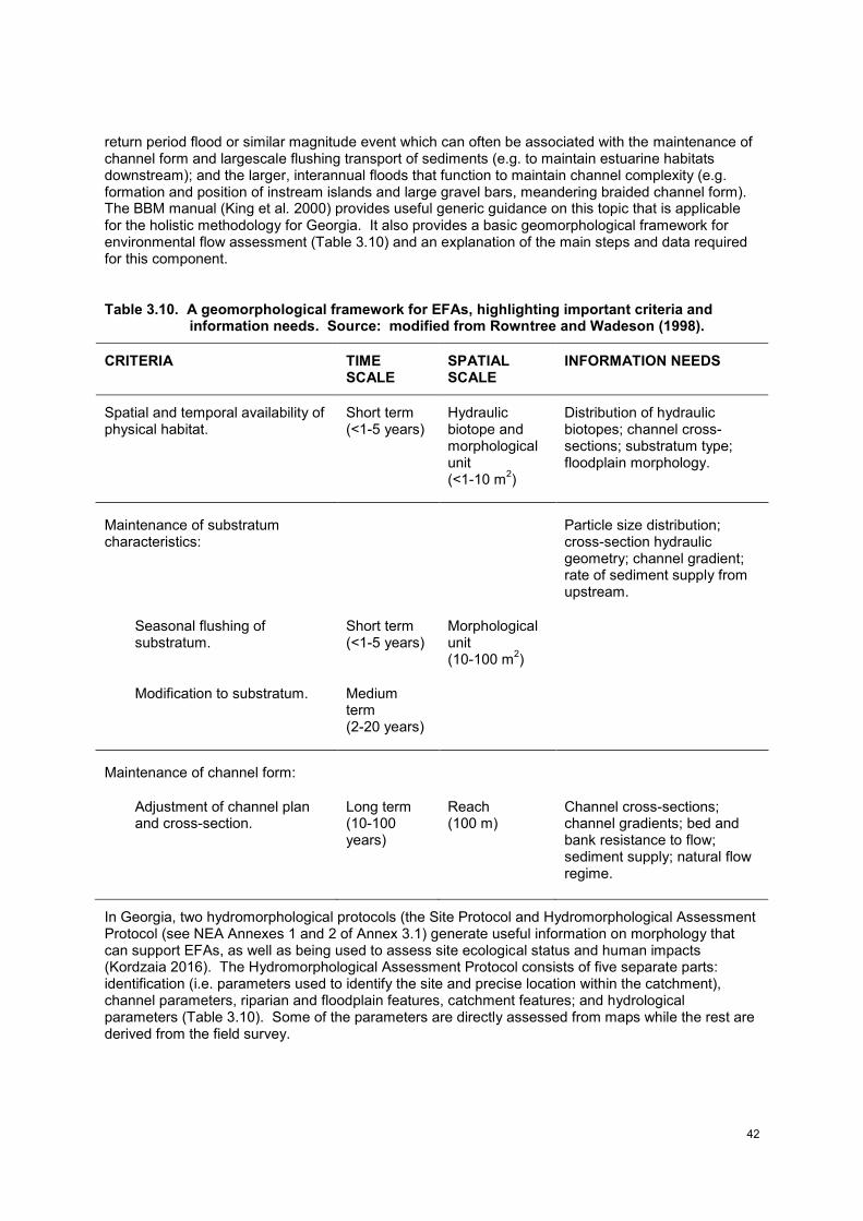
42
return period flood or similar magnitude event which can often be associated with the maintenance of channel form and largescale flushing transport of sediments (e.g. to maintain estuarine habitats downstream); and the larger, interannual floods that function to maintain channel complexity (e.g. formation and position of instream islands and large gravel bars, meandering braided channel form). The BBM manual (King et al. 2000) provides useful generic guidance on this topic that is applicable for the holistic methodology for Georgia. It also provides a basic geomorphological framework for environmental flow assessment (Table 3.10) and an explanation of the main steps and data required for this component.
Table 3.10. A geomorphological framework for EFAs, highlighting important criteria and information needs. Source: modified from Rowntree and Wadeson (1998).
CRITERIA TIME SCALE
SPATIAL SCALE
INFORMATION NEEDS
Spatial and temporal availability of physical habitat.
Short term (<1-5 years)
Hydraulic biotope and morphological unit (<1-10 m
2)
Distribution of hydraulic biotopes; channel cross-sections; substratum type; floodplain morphology.
Maintenance of substratum characteristics:
Particle size distribution; cross-section hydraulic geometry; channel gradient; rate of sediment supply from upstream.
Seasonal flushing of substratum.
Short term (<1-5 years)
Morphological unit (10-100 m
2)
Modification to substratum. Medium term (2-20 years)
Maintenance of channel form:
Adjustment of channel plan and cross-section.
Long term (10-100 years)
Reach (100 m)
Channel cross-sections; channel gradients; bed and bank resistance to flow; sediment supply; natural flow regime.
In Georgia, two hydromorphological protocols (the Site Protocol and Hydromorphological Assessment Protocol (see NEA Annexes 1 and 2 of Annex 3.1) generate useful information on morphology that can support EFAs, as well as being used to assess site ecological status and human impacts (Kordzaia 2016). The Hydromorphological Assessment Protocol consists of five separate parts: identification (i.e. parameters used to identify the site and precise location within the catchment), channel parameters, riparian and floodplain features, catchment features; and hydrological parameters (Table 3.10). Some of the parameters are directly assessed from maps while the rest are derived from the field survey.
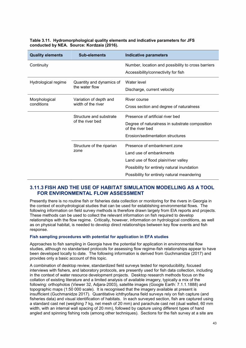
43
Table 3.11. Hydromorphological quality elements and indicative parameters for JFS conducted by NEA. Source: Kordzaia (2016).
Quality elements Sub-elements Indicative parameters
Continuity Number, location and possibility to cross barriers
Accessibility/connectivity for fish
Hydrological regime Quantity and dynamics of the water flow
Water level
Discharge, current velocity
Morphological conditions
Variation of depth and width of the river
River course
Cross section and degree of naturalness
Structure and substrate of the river bed
Presence of artificial river bed
Degree of naturalness in substrate composition of the river bed
Erosion/sedimentation structures
Structure of the riparian zone
Presence of embankment zone
Land use of embankments
Land use of flood plain/river valley
Possibility for entirely natural inundation
Possibility for entirely natural meandering
3.11.3 FISH AND THE USE OF HABITAT SIMULATION MODELLING AS A TOOL FOR ENVIRONMENTAL FLOW ASSESSMENT
Presently there is no routine fish or fisheries data collection or monitoring for the rivers in Georgia in the context of ecohydrological studies that can be used for establishing environmental flows. The following information on field survey methods is therefore drawn largely from EIA reports and projects. These methods can be used to collect the relevant information on fish required to develop relationships with the flow regime. Critically, however, information on hydrological conditions, as well as on physical habitat, is needed to develop direct relationships between key flow events and fish response.
Fish sampling procedures with potential for application in EFA studies
Approaches to fish sampling in Georgia have the potential for application in environmental flow studies, although no standarised protocols for assessing flow regime-fish relationships appear to have been developed locally to date. The following information is derived from Guchmanidze (2017) and provides only a basic account of this topic.
A combination of desktop review, standardized field surveys tested for reproducibility, focused interviews with fishers, and laboratory protocols, are presently used for fish data collection, including in the context of water resource development projects. Desktop research methods focus on the collation of existing literature and a limited analysis of available imagery, typically a mix of the following: orthophotos (Viewer 32, Adjara-2003), satellite images (Google Earth: 7.1.1.1888) and topographic maps (1:50 000 scale). It is recognised that the imagery available at present is insufficient (Guchmanidze 2017). Quantitative ichthyofauna field surveys rely on fish capture (and fisheries data) and visual identification of habitats. In each surveyed section, fish are captured using a standard cast net (weighing 7 kg, net mesh of 20 mm) and parachute cast net (dual walled, 60 mm width, with an internal wall spacing of 20 mm), followed by capture using different types of hand angled and spinning fishing rods (among other techniques). Sections for the fish survey at a site are
44
pre-selected and vary between 100 and 500 metres reach length. The cast net catch is analysed, generating a range of quantitative indicators including total and species level abundances. Using this information, for local mountainous rivers species unit-weight relationships have been derived which are characteristic of the river per linear kilometer; such information can be used to supplement data collected using standard electrofishing methods. In locations where fish are not sampled, species composition can be compiled virtually using an established international method that has already been piloted in the Enguri and Khrami rivers. A typical habitat passport has been produced for the fish of the Adjaristskali Basin which potentially has wider application. The method used for visual identification of habitats (unspecified) ensures that all types of typical habitats are assessed within the study reach and also includes general hydrological features (river mainstems and tributaries are considered). While a catch and release policy is generally applied for fish field surveys, some specimens are transported to the laboratory where data are collected using widely accepted standard methods, including on: sex and maturity stage, age, a nutrition coefficient, meristic and plastic signals, and gut contents.
A representative survey of local fishers is considered an important part of the field assessment for fish assemblage composition and fisheries productivity. Fishers are selected who have a minimum of ten years of experience at the specific location of the fishery. The survey program used has been carefully designed to minimize the risk of obtaining false information (e.g. exaggeration of fish catch data, concealment of certain information), including comparison of the information obtained from at least three fishers each time.
These kinds of standardised procedures have mostly been used for impact-oriented research on ichthyofauna at hydro-electric stations in the Enguri (2011-2012) and Khrami (2012) rivers, but have potential for further development for application in EFAs. Various local institutions, including the Black Sea Monitoring Center of NEA, and regional EU projects, can provide useful protocols and sources of fisheries data. Particularly useful are those studies that document relationships between fish species, including migratory species, the fishery and freshwater inflows to estuaries and the nearshore coastal environment of the Black Sea.
Key references for fish
The following ichthyology guidebooks, texts on field and laboratory survey procedures, and web links are recommended sources of information at this time (Guchmanidze 2017).
- General Atlas of Georgia. Maps of fish distributions. Note: There is no electronic version available. Although the map is very general and there are some inaccuracies, it remains a useful source of information.
- Kimberly Damon-Randall, Russell Bohl, Stephania Bolden, Dewayne Fox, Christian Hager, Brian Hickson, Eric Hilton, Jerre Mohler, Erika Robbins, Tom Savoy, Albert Spells. 2010. Atlantic sturgeon research techniques. NOAA technical memorandum NMFS-NE 215. Published: Woods Hole, Mass.: U.S. Dept. of Commerce, National Oceanic and Atmospheric Administration, National Marine Fisheries Service, Northeast Region, Northeast Fisheries Science Center. 74 p.
- Зиновьев Е.А; Мандрица С.А. 2003. ,,Методы исследования пресноводных рыб”. Пермь. Стр. 113.
- Правдин И. Ф. 1966. ,,Руководство по изучению рыб (преимущественно пресноводных)”. Изд. «Пищевая промышленность» М. Стр. 376.
- Чугунова Н. И. 1959. ,,Руководство по изучению возраста и роста рыб”. Издателство академии наук СССР. Москва. Стр. 165.
- Руководство по изучению питания рыб в естественных условиях / Под ред. Е.Н. Павловского — М.: Изд-во Академии наук СССР, 1961. — 263 с.
- Сакун О.Ф., Буцкая Н.А. 1963. Определение стадий зрелости и изучение половых циклов рыб. Мурманск, Рыбное хозяйство, 46 с.
- Мельничук Г.Л. 1974. Методическое пособие по изучению питания и пищевых отношений рыб в естественных условиях. Л.: Изд-во ГоснИОРХ, 253 с.
- Мельничук Г.Л. 1986. Методические рекомендации по применению современных методов изучению питания рыб и расчета рыбной продукции по кормовой базе в естественных водоемах.-Л.:Изд-во ГосНИОРХ, 38с.
- Эланидзе Р. Ф. 1983. ,,Ихтиофауна рек и озер Грузии”. Изд-во «Мецниереба». Тбилиси. Стр. 320. с картой и цветными рисунками.
45
- Froese, R. and D. Pauly. (Editors). 2012. FishBase. World Wide Web electronic publication. www.fishbase.org. version - 08/2012.
- River Habitat Survey in Britain and Ireland. Field Survey Guidance Manual: 2003 Version. Guidelines for the collection and analysis of fish and fish habitat data for the purpose of assessing impacts from small hydropower projects in British Columbia. Prepared by: Todd Hatfield Solander Ecological Research Ltd. Victoria BC Adam Lewis EcoFish Research Ltd. Courtenay BC Scott Babakaiff BC Ministry of Environment Surrey BC.
- Welker, T. L., and M. R. Drobish. (editors), 2010. Missouri River Standard Operating Procedures for Fish Sampling and Data Collection, Volume 1.5. U.S. Army Corps of Engineers, Omaha District, Yankton, SD.
- http://www.env.gov.bc.ca/fish/. - Fauna Europea. 2012. http://www.faunaeur.org. - Kottelat M; Freyhof J. 2007. Handbook of European freshwater fishes. Publications Kottelat,
Cornol, Switzerland. 646 pp. - A special issue in the journal Hydrobiologia, March 2013, entitled "Water Bodies in Europe -
integrative systems to assess ecological status and recovery" summarises the results of the EU-funded WISER project and may provide useful information on fish and other ecosystem components pertinent to Georgian rivers. The special issue includes 31 peer-reviewed papers addressing the assessment and restoration of rivers, lakes, coastal and transitional waters in Europe.
Habitat simulation modelling for target fish species
Modelling the dynamics of physical habitat across a specific discharge range for different target biota, specifically fish species of ecological and/or social importance, is a central element of the Georgian environmental flow methodology (Section 1.5; USAID G4G 2017) founded on ecohydraulics theory (Section 2.1). Habitat simulation methods are well established for environmental flow assessment and increasingly incorporated as a tool in holistic methodologies (as discussed in Section 2.2.1; see also Jowett 1997, and Tharme 2003). Habitat simulation modelling should be applied alongside complementary, equally valuable ecohydrological analyses that focus on key flow event-based requirements of the most important fish species, life stages and guilds present at the different environmental flow sites (see below). The fish ecologist is responsible for these aspects of the EFA, and is commonly supported in the field surveys of physical habitat by the hydraulic modelling specialist on the EFA team.
The approach for physical habitat-based modelling should follow the well-established basic procedures laid out within the Instream Flow Incremental Methodology (IFIM) (Bovee 1982; Stalnaker et al. 1994; Bovee et al. 1998) which have been commonly adopted worldwide. The IFIM was originally developed by the Instream Flow Group of the U.S. Fish and Wildlife Service (USFWS) in Fort Collins, Colorado, USA, as a decision-making framework for assessing the impacts of water development projects on aquatic ecosystems (Bovee 1982; Bovee et al. 1998). Computer models provided a mechanism for quantifying aquatic habitat per unit length of stream by linking stream channel hydraulics with habitat suitability criteria to create a habitat index called weighted usable area (WUA). Additional models then could link this habitat index to hydrology to place it in the context of flow variability and generate time series analyses of total habitat at different flows. The collection of models to perform the quantification of microhabitat area per unit length of stream are collectively known as Physical Habitat Simulation (PHABSIM) and are detailed in key references such as: Bovee and Milhous (1978) and Bovee et al. (1998).
For flow-habitat simulation modelling to be possible, field surveys are needed of target fish species abundances in a variety of relevant habitats at a range of discharge magnitudes (low to high flows), to construct habitat suitability curves (or multivariate models). An equal-effort sampling scheme should be applied with recording of both habitat use and availability. The reach study scale is the microhabitat, as the common standard (Bovee et al. 1998), with point microhabitat data collected on depths, velocities and substratum conditions; however, the meso-scale could be also considered, if field survey and data processing limitations suggest this scale may be more cost-effective. The approach for habitat suitability modelling will depend on the sampling size, data variability and prevalence of the data for fish species or guilds (similarly for invertebrates, see below). Simple habitat suitability curves are easier to generate, showing habitat selection in a univariate way, but ignore significant interactions between variables which may introduce bias. Multivariate approaches,
46
for example, manage variable interactions better, and some of them are relatively transparent and easy to communicate, e.g. fuzzy logic approach (Muñoz-Mas et al. 2012, 2016).
The field work additionally involves the stratification of habitat types and definition of a representative reach comprising the habitat types (e.g. in the form of channel geomorphic units) for a specific type of river reach. A survey is required of the river channel topography, water surface elevation at different discharges, and ecological characteristics, to calibrate a hydraulic mode used to evaluate reach habitat suitability at different flows. The number of cross-sections for a hydraulic and habitat simulation varies; the challenge in developing a river model is to include sufficient diversity without oversampling. In rivers with diverse habitats, 18-20 transects provides stable results regarding the habitat assessment, although this number can be reduced in rivers of low complexity. For the number and location of transects assessments can follow common criteria for IFIM applications. Depending on river and reach complexity, habitat simulation modelling may be performed in 1 (1D) or 2 (2D) dimensions. One-dimensional models provide a good balance between cost and results and are considered reliable for such applications. The default procedure might be a 1-dimensional simulation, with the measurement of one velocity profile in each cross-section (“1-vel method”) at a high and safe flow rate, and three levels of water surface at high, medium and low flows. On the other hand, the flow physics of 2D models are better able to model flow patterns over a complex river bed that includes obstructions, islands and meanders; 2D models, with a higher cost in field survey and computation, should only be applied in reaches of high habitat complexity. One suitable software package for 1D habitat simulation is the System for Environmental Flow Analysis, SEFA (Payne et al. 2012; see below). The outputs of the habitat assessment should be summarised as habitat suitability maps and Weighted Usable Area (WUA)-flow curves indicating the amount of suitable physical habitat for the target species or guilds at various discharge magnitudes, for priority study reaches for the EFA.
Analysis of habitat shifts due to changes in flow regime over time may be performed with the development of Habitat Time Series (HTS) and Habitat Duration Curves (HDC) (Bovee et al. 1998). These analyses are usually based on average daily discharges (except in cases where hydropower plant operation might affect the intra-daily pattern of stream flows, when a finer modelling time step might be more appropriate). Such curves provide a dynamic view of the river flow regime, based on the streamflow series and the WUA-discharge curves, thereby illustrating the potential long-term impact of different flow scenarios in comparison with the reference or baseline conditions.
Further details on habitat simulation modelling, and useful examples for fish, are provided in the project supplemental 2016 training materials, as well as in the various references provided in this section below. A vast body of literature exists on the subject and it is beyond the scope of this guide to fully cover it.
The System for Environmental Flow Analysis as a tool for habitat simulation analyses
Several recent technological and generational changes have led to the need for improved approaches to riverine habitat modelling for environmental flow assessment. The System for Environmental Flow Analysis, SEFA) has evolved from other internationally recognised, well tested software packages for physical habitat simulation (viz. the physical habitat simulation component of the Instream Flow Incremental Methodology (IFIM), PHABSIM; RHYHABSIM; and RHABSIM) to fill this niche (Payne et al. 2012; Payne and Jowett Undated). The System for Environmental Flow Analysis is a newly developed, not-for-profit technical and educational support software package for river habitat simulation modelling that includes a user manual (http://sefa.co.nz/). It is a potentially very useful tool for the various steps in the Georgian methodology which address hydraulic habitat simulation for instream biota (USAID G4G 2017); Georgian researchers were trained in some of the basics of SEFA in 2016. The software comprises one dimensional habitat hydraulics analysis, habitat suitability criteria development, water temperature modeling, sediment transport analysis, dissolved oxygen modeling, riparian modeling, time series analysis, and externally references to legal-institutional analysis and two-dimensional modeling.
47
Additional reading on habitat simulation modelling and field survey methods
The following online information sources provide background on the methodological approach used in IFIM and other habitat simulation methods, as well as additional recommended reading on field methods for this stage of the EFA):
General - the five phases of IFIM - http://www.fort.usgs.gov/Products/Software/ifim/5phases.asp
stream habitat analysis using the IFIM -
http://www.fort.usgs.gov/products/Publications/3910/preface.html
Additional information - http://www.fort.usgs.gov/Products/Software/IFIM/
PHABSIM for Windows user's manual and exercises (freely available on-line) - http://www.fort.usgs.gov/products/Publications/15000/preface.html
Chapter 1. Introduction to the Physical Habitat Simulation System (PHABSIM) - http://www.fort.usgs.gov/products/Publications/15000/chapter1.html#top
Chapter 3. Habitat Suitability Criteria - http://www.fort.usgs.gov/products/Publications/15000/chapter3.html
Data collection procedures for the Physical Habitat Simulation System (which covers most field techniques) - http://www.fort.usgs.gov/Products/Publications/20002/20002.pdf
Development and evaluation of habitat suitability criteria for use in the instream flow incremental methodology - http://www.fort.usgs.gov/Products/Publications/1183/1183.pdf
Proceedings of a workshop on the development and evaluation of habitat suitability criteria (1986) - http://www.fort.usgs.gov/Products/Publications/22686/22686.pdf
Snorkelling techniques for microhabitat studies of fish habitat selection - Martínez‐Capel, F., García de Jalón, D., Werenitzky, D., Baeza, D. and Rodilla‐Alamá, M. 2009. Microhabitat use by three endemic Iberian cyprinids in Mediterranean rivers (Tagus River Basin, Spain). Fisheries Management and Ecology 16(1): 52-60.
Point sampling technique for microhabitat studies of fish habitat selection - Watkins, M. S., Doherty, S. and Copp, G. H. 1997. Microhabitat use by 0+ and older fishes in a small English chalk stream. Journal of Fish Biology 50(5): 1010-1024.
Payne, T. R., Eggers, S. D. and Parkinson, D. B. 2004. The number of transects required to compute a robust PHABSIM habitat index. Hydroécologie appliquée 14: 27-53.
Costa, M. R. D., Mattos, T. M., Fernandes, V. H., Martínez-Capel, F., Muñoz-Mas, R. and Araújo, F. G. 2015. Application of the physical habitat simulation for fish species to assess environmental flows in an Atlantic Forest Stream in South-eastern Brazil. Neotropical Ichthyology 13(4): 685-698.
Muñoz-Mas, R., Martínez-Capel, F., Garófano-Gómez, V. and Mouton, A. M. 2014. Application of probabilistic neural networks to microhabitat suitability modelling for adult brown trout (Salmo trutta L.) in Iberian rivers. Environmental Modelling & Software 59: 30-43.
Ecohydrological approaches for fish
Direct relationships between different low flow and high flow events and fish can be developed in a number of ways, in addition to those mediated by physical habitat conditions, as described above and in Box 3.2. Whether derived from the literature or empirically through field based sampling at different times of the year, fish observational data need to be linked to the most relevant hydrological characteristics of individual flow events (e.g. as illustrated in Box 3.1; Section 3.9) as well as to the longer time series of average daily discharges within and between years.
In addition to the flow-hydraulic habitat relationships described above, the specific life cycle requirements of indicator species (e.g. iconic large fish species of high conservation value or of economic importance) can be linked to different flow events at various times of the year, through a combination of literature review, expert knowledge and field surveys. For example, see Box 3.1. Specific high flow pulses and small flood events, for example, can act as cues known to trigger the migration and spawning of certain species. Migratory species, such as long-distance migrants which travel between the Black Sea and inland river reaches may be an especially useful and critical group to consider in terms of their flow requirements, especially at certain times of the year when longitudinal passage is necessary in either direction. Larger floods, for example those responsible for the formation of morphological features that represent important physical habitat for fish (and similarly,
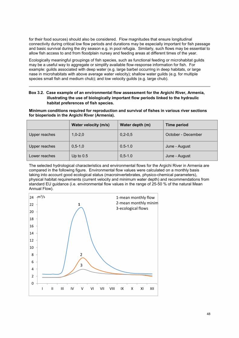
48
for their food sources) should also be considered. Flow magnitudes that ensure longitudinal connectivity during critical low flow periods and durations may be especially important for fish passage and basic survival during the dry season e.g. in pool refugia. Similarly, such flows may be essential to allow fish access to and from floodplain nursey and feeding areas at different times of the year.
Ecologically meaningful groupings of fish species, such as functional feeding or microhabitat guilds may be a useful way to aggregate or simplify available flow-response information for fish. For example: guilds associated with deep water (e.g. large barbel occurring in deep habitats, or large nase in microhabitats with above average water velocity); shallow water guilds (e.g. for multiple species small fish and medium chub); and low velocity guilds (e.g. large chub).
Box 3.2. Case example of an environmental flow assessment for the Argichi River, Armenia,
illustrating the use of biologically important flow periods linked to the hydraulic
habitat preferences of fish species.
Minimum conditions required for reproduction and survival of fishes in various river sections for bioperiods in the Argichi River (Armenia).
Water velocity (m/s) Water depth (m) Time period
Upper reaches 1,0-2,0 0,2-0,5 October - December
Upper reaches 0,5-1,0 0.5-1.0 June - August
Lower reaches Up to 0.5 0,5-1.0 June - August
The selected hydrological characteristics and environmental flows for the Argichi River in Armenia are compared in the following figure. Environmental flow values were calculated on a monthly basis taking into account good ecological status (macroinvertebrates, physico-chemical parameters), physical habitat requirements (current velocity and minimum water depth) and recommendations from standard EU guidance (i.e. environmental flow values in the range of 25-50 % of the natural Mean Annual Flow).
0
2
4
6
8
10
12
14
16
18
20
22
24
I II III IV V VI VII VIII IX X XI XII
m3/s
1
2
3
1-mean monthly flow
2-mean monthly minimu
3-ecological flows
49
Hydrological statistics and ecological flows for the Argichi River at Verdin Getashen hydrological gauging station.
3.11.4 MACROINVERTEBRATES
The macroinvertebrate data collected by NEA as part of its monitoring programme for assessing surface water ecological status (Sections 3.7 and 3.13) can be used to establish specific low flow periods and high flow events to maintain this biotic component and also water quality (rapid bioassessment of invertebrate assemblages provides an integrated measure of water quality, and can also be used as an indicator of the general ecological health), in those instances where flow data are also available for the same EFA reach.
For benthic macroinvertebrate sampling in Georgia, a modified standardised EU multi-habitat sampling method is used, based on the AQEM/STAR methodology (Kordzaia 2016). The AQEM/STAR protocol (AQEM consortium 2002) is the result of two successive EU-funded projects which aimed to develop a standardised aquatic macroinvertebrate sampling protocol and assessment system for running waters, for the purpose of implementing the EU WFD (Hering et al. 2003; Furse et al. 2006). The detailed kick-sampling procedure for macroinvertebrates from different habitat types (including instructions on how to complete the field sampling protocol; see Annex 3.1) is described in the sampling procedure for river macroinvertebrates under the Joint Field Surveys of the EPIRB pilot river basins project (2015). An area of 1 m
2 is sampled during each sampling event at a field site, the
invertebrate samples are fixed with 80% ethanol and transported to the laboratory for sorting and identification. Identification of the macroinvertebrates is to the taxonomic level of family (or genus) based on available identification keys and national literature resources. The results are transferred in a standardised format to a database maintain by NEA, which provides a useful long-term repository of information on invertebrates that can be linked to flow regime and other factors. The ASTERICS software (from the AQEM project) is used to calculate metrics for the macroinvertebrate assemblages and taxa from the raw data. These metrics can be assessed in terms of the strengths of their relationships with different low and high flow indices (derived from IHA or other hydrological analysis). This information can then be used to motivate for specific flow events to be included in the Environmental Flow Schedule.
Key source references for invertebrate sampling
- AQEM consortium. 2002. Manual for the application of the AQEM method A comprehensive method to assess European streams using benthic macroinvertebrates, developed for the purpose of the Water Framework Directive Version 10, February 2002.
- AQEM and STAR Site Protocol. 2002. wwweu-starat Protocols.
- EN 16150: 2012 Water quality – Guidance on pro-rata multi-habitat sampling of benthic macro-invertebrates from wadeable rivers European Standard, April 2012 CEN (16 p).
- EN 16164: 2013 Water quality – Guidance standard for designing and selecting taxonomic keys European Standard, January 2013 CEN (14 p).
- EN ISO 10870: 2012 Water quality - Guidelines for the selection of sampling methods and devices for benthic macro-invertebrates in fresh waters (ISO 10870:2012) European Standard, July 2012 CEN (36 p).
- JFS III design manual: Biological EPIRB project, May 2015.
- Sampling procedure for river macro-invertebrates in joint field surveys of EPIRB pilot river basins: short instruction on how to fill in the site protocol.
Some approaches for establishing key flow events for invertebrates
Relationships between different discharges or time series of discharge and suitable hydraulic habitat (WUA) for invertebrate assemblages, functional guilds (e.g. riffle or pool dwelling assemblages) or species, can be derived in an analogous way to that described for fish (see Section 3.11.3). Numerous examples exist in the literature of the flow-related hydraulic habitat preferences of invertebrates, among others, Gore (1989) and Jowett et al. (1991). As is the case with the development of fish habitat-flow relationships, transect and point-based microhabitat data are required
50
at different discharges in the study reach, to develop such invertebrate-habitat discharge time series and duration curves. These curves can then be used by the invertebrate ecologist to identify the most suitable discharges for maintaining the composition, abundance and diversity of the local invertebrate assemblage in each reach.
Flow types can be used effectively to develop specific discharge-flow type and flow-biotope (or hydraulic habitat or mesohabitat) relationships for benthic macroinvertebrates (e.g. Padmore 1998). These relations can be used to recommended specific low flow periods or high flow events to maintain the invertebrate assemblages that are characteristic of different types of instream habitats. The flow type and biotope relationships with discharge can also be used more generically, in the absence of specific invertebrate data, to establish recommended flows to maintain a diversity or specific mix of habitat types or different surface area proportions of habitats of different hydraulic conditions within the area of the wetted river channel. The NEA JFS protocol for the assessment of hydromorphology includes site-based information on hydraulic habitat features such as flow types (FF: Freefall, CH: Chute, CA: Chaotic, BS: Broken standing waves, US: Unbroken standing waves, RP: Rippled, UP: Upwelling, SM: Smooth, NO: No perceptible flow) that could potentially be adapted for this purpose.
Ecologically relevant flows for invertebrates can also be determined using direct relationships between different measures of the invertebrate assemblage and various flow statistics that represent important flow regime characteristics or events. For instance, Monk et al. (2006) found various relationships between macroinvertebrate community metrics at family level and 201 different monthly and annual flow regime descriptors identified from various ecohydrological studies. In another example, 13 flow indices reflecting different aspects of high, low, and average flows showed strong relationships with 14 invertebrate metrics, exerting positive or negative upper or lower limits on assemblage composition (Konrad et al. 2008).
3.11.5 WATER QUALITY
Other than the information provided in the NEA protocol on survey methods and protocols for assessment, information on water quality, particularly focused on relationships between water physico-chemistry and flow regime, was limited.
Data on the seasonal oxygen conditions, temperature regime, and other relevant water quality parameters of each EFA site should be collated, where available. If such data are not available, field survey(s) should be conducted using standard protocols (e.g. as per the NEA protocol; Table 3.11). Field sampling should preferably be undertaken in both the dry and wet seasons of the year, to reflect water quality dynamics with both low and high flow events.
Table 3.12. Physico-chemical quality elements for JFS conducted by NEA. Source: Kordzaia (2016).
Quality elements Indicative parameters
thermal conditions water temperature
oxygenation conditions dissolved oxygen, oxygen saturation BOD5 COD total suspended solids
nutrient conditions NO3 NH4 PO4 (orthophosphates)
salinity Conductivity Cl SO4 total dissolved solids (total mineralization)
acidification status pH
The sampling protocol for physico-chemical assessment is completed by the JFS sampling team for each sampling location, during all sampling rounds. Furthermore, in situ parameters (pH, T, O2,
51
conductivity, colour and odour) are recorded along with hydrological and biophysical site conditions and included in the field protocol (see Annex 3.1). Standardised, accredited methods are used for the subsequent laboratory analysis of physico-chemical quality parameters.
Critically, water quality needs to be linked to flow conditions at the site, due to the recognised, sometimes complex relationships that exist between discharge magnitude and physio-chemical variables, from temperature and oxygen, through to nutrients. The timing, duration and discharge magnitude during low flow periods of the year are often critical to consider from a water quality perspective, when several parameters may become limiting for the biota (e.g. temperature, dissolved oxygen, conductivity). High flows can also have important roles to play, for example, in the transport of nutrients and sediments within the river system. The BBM manual (King et al. 2000) provides some useful generic guidance on this topic.
3.11.6 VEGETATION
Other than the information provided in the NEA protocols, no specific information on riparian or instream vegetation, including aquatic macrophytes and algae, or the survey methods used in Georgia was readily available.
There appear to be no existing standardised methods for surveying vegetation in routine use in Georgia at present that could be adapted to help assess the flow-related requirements of riparian and instream vegetation. The NEA JFS protocol for macroinvertebrate assessment, however, includes some information on the presence/absence and degree of cover of different types of algae and macrophytes, the width, length and basic plant composition of the riparian zone, and instream hydraulic habitat features of the river channel. Furthermore, the NEA protocol for the assessment of hydromorphology also includes information on the characteristics of instream and riparian floodplain vegetation that could be a useful complement to the specialist information collected in the field by the EFA team botanist.
The BBM manual of King et al. (2002) provides useful generic guidance on the development of flow-vegetation response relationships at low and high flows that can be used by a botanist or, where one is not available, a river ecologist, to develop environmental flow recommendations. Vegetation guilds, indicator species and their flow-related life cycle requirements, and general characteristics of vegetation can all be used to identify critical flow events for this ecosystem component. For instance: relations with flow may be found between smaller high flow pulses and the recruitment of tree seedlings on instream gravel bars; high flows may recharge bank groundwater stores critical for the longevity and vigour of large riparian trees; and the overall width and diversity of different zones of vegetation, such as emergent sedges, reeds and grasses, may be linked to the magnitude and duration of dry and wet season low flow periods.
Several recent publications can be consulted that address the conceptual basis of riparian vegetation response to flow alteration and associated methods and tools for determining environmental flows for vegetation. For example, see Merritt et al. (2010) and Lytle et al. (2017).
3.11.7 SOCIAL SURVEY AND ANALYSIS
No specific information was made available on the flow-related social uses of rivers and streams in Georgia or on the desktop and field survey methods available for use (other than for fisheries, see the Section on fish and fisheries). It is evident, however, that there are a variety of cultural services and other features of importance, including in economic terms (e.g. inland and coastal fisheries), that have the potential for inclusion in the methodology. These include, among others: river recreation (instream and on river and coastal beaches, e.g. fishing, swimming), fisheries, waterfalls and other features of aesthetic and amenity value, and ecotourism opportunities (e.g. rafting).
Social links to the flow regime may be particularly important to assess in those parts of a river basin where communities directly depend on river natural resources for their livelihoods. For example, the flow regime may support vital food production services for local consumption or as a source of income, such as fisheries or flood-linked crop production along stream margins. River flows also supply reliable sources and stores of good quality water for use by people, including for bathing, washing or recreation. For example, very low flows during critical dry season months (a socially important bioperiod) may result in poor ambient water quality, affecting human uses of the resource.
52
There can be cultural or spiritual practices associated with specific kinds of flow events in certain communities, e.g. baptism. Some of the more intangible relationships between river flow regimes and people may be important, but require a different form of expression that empirically derived flow-social response curves. It may be possible to economically value some of the human dependencies on the flow regime, such as fisheries, but not all relationships are necessarily quantifiable in monetary terms. There can also be certain disservices of the flow regime to people that need to be considered during an EFA, such as flooding risk or links to waterborne diseases. Very high flows during the wet season may support local river transportm but prevent safe river crossing in certain reaches due to elevated water depths and velocities.
It is the role of the social scientist on the EFA team to identify and document, either in qualitative or, where feasible, more quantitative terms, the various ecosystem services and other dependencies people have for both low and high flows. Many social sciences methods are well suited for environmental flows studies with little further adaptation needed, such as Participatory Rural Appraisal, key informant interviews and transect walks, and should be well known to the social scientist.
The BBM manual of King et al. (2000), the DRIFT methodology (King et al. 2003; King and Brown 2010) and the USAID (2016) EFA for the Rufiji Basin of East Africa provide useful methods, case examples, and some generic guidance. Interesting recent examples of the importance of and use of traditional ecological knowledge (TEK) Indigenous knowledge, and cultural and other ecosystem services in environmental flow assessment are provided in Finn and Jackson (2011); Jackson et al. (2014); and Martin et al. (2015), among others (see also Poff et al. 2017). For example, fish-flow conceptual models that effectively integrated both indigenous and scientific knowledge supported environmental flow determination in the Daly River, Australia (Jackson et al. 2014). Martin et al. (2015) developed relationships between river flow regime and social preferences for a US river, in the Yampa-White River Basin, Colorado.
3.12. COMPLETION OF THE ENVIRONMENTAL FLOW REQUIREMENT SCHEDULE (STEP 13)
The Environmental Flow Requirement schedule (USAID G4G 2017) should be compiled based on all of the individual flow recommendations for survival flows, low flow periods and high flow events. Table 1.1 (Section 1.5) above provides a hypothetical example for an environmental flow site for a coastal river type. The schedule should be supported by documentation of the various ecological and social reasons for each of the individual flow events included. The degree of confidence held by the specialists in each of the recommended flows should be made explicit. It must be reviewed for completeness before finalisation, and should include an explanation of the levels of confidence in the results, as well as of any constraints, limitations, and major gaps or areas of uncertainty.
The coordinator is usually tasked with the production of the Environmental Flow Requirement schedule. This synopsis of the environmental flow results should ideally be accompanied by an environmental flow monitoring plan (Section 3.13), with both housed within a final EFA report documenting the entire EFA process. The EFA final report should be reviewed by the specialist team for accuracy. It should also be subject to rigorous external review by one or more environmental flow experts. It is recommended that the EFA report be made publically available and that its main findings be shared with at least the main basin actors during the ongoing stakeholder consultation process.
3.13. MONITORING AND REPORTING (STEP 14)
In this guide, the focus is exclusively on inland surface waters. Greater attention is needed on the development of monitoring protocols for transitional and coastal waterbodies, and for groundwater. Where such protocols are in place, even in a basic form, they should also be consulted and are likely to be especially important to consider for those river basins with estuaries along the Black Sea coastline.
Monitoring and reporting are critical steps in the methodology to ensure practical implementation of the recommended environmental flow regime (the environmental flow requirements schedule), from monitoring of compliance with the recommended flows and progress towards the achievement of
53
GES, through to adaptive management to refine or update the flow recommendations, fill in critical gaps in understanding, and address any major areas of uncertainty that increase risk.
The EU WFD requires that surface water monitoring is designed and established in such way that a coherent and comprehensive overview of the ecological and chemical status within each river basin can be provided (WFD Annex V). The monitoring design should also facilitate the classification of the water resource units into one of the five classes consistent with the normative definitions provided (WFD Annex V). While not specifically oriented towards the monitoring of environmental flows, the guidance under the WFD provides a useful starting point. See for example: Guidance Document No 7: Monitoring under the Water Framework Directive, produced by Working Group 27 – Monitoring Common Implementation Strategy for the Water Framework Directive (2000/60/EC), Luxembourg: Office for Official Publications of the European Communities, 2003 (153 pp.) Indicators and procedures for monitoring of good ecological status for river reaches and sites should be as aligned as possible with those used for the environmental flow assessment. Section 6 of WFD CIS (2015) provides a detailed discussion of monitoring programmes in the EU WFD context.
To properly monitor and adaptively refine the environmental flow recommendations, it is necessary to use a combination of biological, hydromorphological (including hydrological) and physico-chemical indicators that reflect a combination of potential short-term and longer-term responses to the modified flow regime. General guiding principles for indicator selection are summarized in Box 3.2. A tiered monitoring approach may be especially useful, with a first simple level of monitoring that can be conducted by non-technical persons with only basic training e.g. by members of the community using citizen science techniques. Additional more technically sophisticated levels of monitoring can then be undertaken by technicians and other professionals (e.g. university researchers).
Hydrological monitoring at key management control points within the river system, at the level of at least a continuous ongoing time series of observations of average daily discharge (or finer, in the case of peaking hydropower operations) is a basic requirement. Additionally, the current NEA Joint Field Survey (JFS) standard protocols for surface water monitoring (see Annex 3.1) provide essential information on the status of each of the following river ecosystem components, and in a structured and repeatable way:
- Macroinvertebrates - Hydromorphology, including hydrological features - Physico-chemistry
As such, these protocols provide useful information and potential ecological indicators for environmental flow monitoring. While presently absent, there is high potential to also establish JFS protocols for other key ecosystem components, notably fish and vegetation, as well as to augment the current procedures on morphology and physical habitat.
Box 3.3. Guiding principles for indicator selection. Source: Jackson et al. (2000).
As a guiding principle, it is better to select a few indicators that are meaningful than to try to measure everything. The important goal is to select indicators that can help diagnose the likely causes of observed degradation and guide management actions.
Important general criteria for the selection of indicators include the following:
Conceptual relevance: the indicator must provide information that is relevant to societal concerns about ecological condition.
Feasibility of implementation: adapting an indicator for use in a large or long-term monitoring programme must be feasible and practical.
Response variability: it is essential to understand the components of variability in indicator results to distinguish irrelevant factors from a true environmental signal.
Interpretation and utility: a useful indicator must produce results that are clearly understood and accepted by scientists, policymakers and the public.
54
4. CONCLUDING REMARKS Several of the main steps in the methodology are limited in the guidance that can be provided at present, especially given that environmental flows practice and the capacity to support it are at an early stage of development in Georgia. There are also some significant gaps in data and expertise that could potentially constrain the comprehensive application of the new holistic methodology (a combined hydrological -socioecological approach at the ecosystem level). The methodology has been designed, however, to be applicable in a data and resource-limited context. In such instances, the level of expertise of the multidisciplinary team involved in any EFA becomes particularly important.
Although attention is being placed on the expansion of the network of hydrological gauging stations for Georgia, the historical time series of observed average daily discharges are unequally distributed and there are significant gaps in some flow records for the major rivers of the country (NEA Hydrometeorology Department 2016). These data are indispensable for the process of setting environmental flows and then monitoring compliance, and further efforts should be invested in advancing the hydrological methods and tools needed to establish continuous long-term flow time series and generate simulated records for ungauged areas of the country. There is also only limited access to hydrological data for HPP projects and for other kinds of water use data (e.g. water abstractions) which are useful sources of information for EFAs. Hydrological monitoring at priority management control points within the river system, at the level of at least a continuous time series of observations of average daily discharge is essential, yet currently not a consistent practice. In the case of hydropower projects specifically (e.g. peaking hydropower operation), it may also be necessary to obtain more detailed hydrological time series of within-day fluctuations in discharge/water levels. Such flow variations may have particularly deleterious effects on aquatic biota and need to be monitored at a finer time step.
It is strongly recommended to introduce a baseline joint, fully integrated biological, physico-chemical and hydromorphological monitoring programme for the surface waters in Georgia. The NEA protocols provide a suitable basis from which to expand, particularly if fish, morphology (including physical habitat) and vegetation (riparian vegetation, as well as potentially also macrophytes and phytoplankton, where relevant) are more regularly and consistently assessed alongside macroinvertebrates and water quality. The results from the national monitoring programme conducted by NEA have high potential for use to determine environmental flows in the river basins of Georgia, particularly if these other biological quality elements are added. Early information obtained in this way could also be used to fully develop the system to classify surface waters in terms of their ecological status (high, good, moderate, poor or bad). This classification system is presently only partially developed and would be an invaluable resource for environmental flow assessment.
At present, monitoring efforts also appear limited, developed in an ad hoc fashion project by project, and therefore are somewhat dispersed. Identifying a set of common reaches for the routine collection of hydrological data and ecological data will be vital for developing the ecohydrological and ecohydraulic relationships that are the basis of environmental flow recommendations. The establishment of a typology of rivers and streams for the country will help ensure an adequate, even distribution of sampling locations across the diversity of system types, as well as facilitating the identification of appropriate sites reflecting reference conditions. Monitoring should be extended to cover all priority locations where significant pressures/stressors have been identified. Further development of the existing, but still incipient methods for desktop screening (Section 3.4) would assist in this regard. At present, for instance, there is no method for prioritizing in advance the river basins and sub-basins that are most important to maintain or restore to GES, or those places at greatest risk from existing or future flow alteration.
From a social sciences perspective, while provisioning services, such as fisheries, and cultural services (e.g. recreation, aesthetic and cultural heritage values) can already be included in the new environmental flow methodology, further development of the supporting methods and tools is required. There is quite limited, but rapidly growing, guidance internationally in this evolving area of the discipline that could be drawn upon in future. However, it remains unclear what technical and institutional capacity presently exist in Georgia to undertake this kind of work. Moreover, little information appears to be available to draw upon right now, on human dependencies on river flow
55
regimes. A scoping and consolidation of this area of environmental flows is recommended as a next step.
Further tailoring and adaptation of the new methodology for rivers is needed before its routine application will be possible for the estuaries of local river systems and for temporary rivers. Methodologies also need to be developed for other kinds of water bodies in Georgia, such as lakes and groundwater-dependent wetlands. In all cases, piloting of the methodologies and the development of supporting guidance will be needed. Many of the procedures presented in this guide can be readily adapted for application in some of these other context, given the holistic and interdisciplinary nature of the basic approach.
Some additional challenges and opportunities were also discussed in the interim project report produced following the 2016 environmental flow training workshop (see Final Report of the USAID G4G Project Refining Environmental Flow Methodology and Preparatory Work for Environmental Testing Work Plan, Appendix III) that may be worth reflecting on.
With increasing application of the methodology and the amendments to its procedures that can be expected to result, the guide will need to be updated. Regular revisions of the guide are therefore highly recommended, particularly during the first five years.
56
REFERENCES
Acreman, M.C. 2016. Environmental flows – basics for novices. WIREs Water 3:622–628. doi: 10.1002/wat2.1160.
Acreman, M.C. and Dunbar, M.J. 2004. Methods for defining environmental river flow requirements - a review. Hydrology and Earth System Sciences 8: 121-133.
Acreman, M. C., and Ferguson, A. J. D. 2010. Environmental flows and the European Water Framework Directive. Freshwater Biology 55:32-48.
Acreman, M., Arthington, A. H. Colloff, M. J., Couch, C., Crossman, N. D., Dyer, F., Overton, I., Pollino, C. A., Stewardson, M. J. and Young, W. 2014a. Environmental flows for natural, hybrid, and novel riverine ecosystems in a changing world. Frontiers in Ecology and the Environment 12:466-473.
Acreman, M. C., Overton, I. C., King, J., Wood, P. J., Cowx, I. G., Dunbar, M. J., Kendy, E. and Young, W. J. 2014b. The changing role of ecohydrological science in guiding environmental flows. Hydrological Sciences Journal-Journal Des Sciences Hydrologiques 59: 433-450.
Annear, T., Chisholm, I., Beecher, H., Locke, A., Aarrestad, P., Burkhard, N., Coomer, C., Estes, C., Hunt, J., Jacobson, R., Jobsis, G., Kauffman, J., Marshall, J., Mayes, K., Wentworth, R. and Stalnaker, C. 2004. Instream flows for riverine resource stewardship. Revised edition. Instream Flow Council, Cheyenne, WY, USA.
Arthington, A. H. 2012. Environmental flows: saving rivers in the third millennium. University of California Press, Berkeley.
Arthington, A. H., Bunn, S. E., Poff, N. L. and Naiman, R. J. 2006. The challenge of providing environmental flow rules to sustain river ecosystems. Ecological Applications 16: 1311-1318.
Bovee, K.D. 1997. Data collection procedures for the physical habitat simulation system. U.S. Geological Survey, Biological Resources Division, Ft. Collins, CO. 141 pp.
Bovee, K.D. 1982. A guide to stream habitat analysis using the instream flow incremental methodology. Instream Flow Information Paper 12. U.S.D.I. Fish Wildl. Serv., Office of Biol. Serv. FWS/OBS-82/26: 248 pp.
Bovee, K.D. and Milhous, R. 1978. Hydraulic simulation in instream flow studies: theory and techniques. Instream Flow Information Paper 5. FWS/OBS-78/33. Cooperative Instream Flow Service Group. Fort Collins, Colorado.
Bovee, K., Lamb, B., Bartholow, J., Stalnaker, C., Taylor, J. and Henriksen J. 1998. Stream habitat analysis using the instream flow incremental methodology. U.S. Geological Survey, Biological Resources Division Information and Technology Report USGS/BRD-1998-0004. 131 pp.
Brisbane Declaration. 2007. The Brisbane declaration. environmental flows are essential for freshwater ecosystem health and human well-being. Declaration of the 10th International River symposium and International Environmental Flows Conference, Brisbane, Australia, 3 - 6 September 2007. https://www.conservationgateway.org/ConservationPractices/Freshwater/EnvironmentalFlows/MethodsandTools/ELOHA/Documents/Brisbane-Declaration-English.pdf
Brown, C. and King, J. 2003. Environmental Flows: Concepts and methods. In Davis, R. and Hirji, R. (eds). Water Resources and Environment Technical Note C.1. Washington, D.C.: The World Bank.
Bunn, S. E. and Arthington, A. H. 2002. Basic principles and ecological consequences of altered flow regimes for aquatic biodiversity. Environmental management, 30(4), 492-507.
Clausen, B., Jowett, I.G., Biggs, B.J.F. and Moeslund, B. 2004. Stream ecology and flow management. In: Tallaksen, L.M., Van Lanen, H.A.J. (Eds.), Developments in Water Science 48. Elsevier, Amsterdam. 313–356 pp.
57
Costa, R., Martinez-Capel, F., Muñoz-Mas, R., Alcaraz-Hernández, J.D. and Garófano-Gómez, V. 2012. Habitat suitability modelling at mesohabitat scale and effects of dam operation on the endangered Júcar nase, Parachondrostoma arrigonis (River Cabriel, Spain). River Research and Applications 28(6): 740-752.
Davis, J.A. and Barmuta, L.A. 1989. An ecologically useful classification of mean and near-bed flows in streams and rivers. Freshwater Biology 21: 271-282.
Diez Hernández, J.M. 2006. Evaluación hidro-ecológica de caudales ambientales: metodología IFIM. Ingeniería de Recursos Naturales y del Ambiente, 5: 66-72.
Finn, M., and S. Jackson. 2011. Protecting Indigenous values in water management: a challenge to conventional environmental flow assessments. Ecosystems 14:1232-1248.
Flotemersch, J. E., Leibowitz, S. G. 2, Hill, R. A., Stoddard, J. L., Thoms, M. C. Thoms and Tharme, R. E. 2016. A watershed integrity definition and assessment approach to support strategic management of watersheds. River Res. Applic. 32: 1654-1671. Published online 23 October 2015 in Wiley Online Library (wileyonlinelibrary.com) DOI: 10.1002/rra.2978.
Furse, M., Hering, D., Moog, O., Verdonschot, P., Johnson, R.K., Brabec, K. et al. 2006. The STAR project: Context, objectives and approaches. Hydrobiologia 566: 3-29.
Gore, J.A. 1989. Models for predicting benthic macroinvertebrate habitat suitability under regulated flows. Pp 253-265. In: Gore, J.A. and Petts, G.E. (eds). 1989. Alternatives in regulated river management. CRC Press, Inc., Florida, U.S.A.
Guchmanidze, A. 2017. Fish desktop, field survey and laboratory methods, and key literature references. Unpublished techncial note. 2 pp.
Hering, D., Buffagni, A., Moog, O., Sandin, L., Sommerhäuser, M. et al. 2003. The development of a system to assess the ecological quality of streams based on macroinvertebrates – design of the sampling programme within the AQEM project. Internationale Revue der gesamten Hydrobiologie 88: 345-361.
Horne, A., O'Donnell, E., Acreman, M., McClain, M.E., Poff, L., Webb, J.A., Stewardson, M.J, Bond, N., Richter, B., Arthington, A., Tharme, R., Garrick, D., Daniell, K., Conallin, J., Thomas, G.A. and Hart, B.T. 2017. Moving forward – the implementation challenges for environmental water management. In: Water for the Environment (Eds) Horne, A., Webb, J.A., Stewardson, M.J, Acreman, M., and Richter., B. Elsevier Press.
Jackson, L.E., Kurtz, J.C. and Fisher, W.S. (eds). 2000. Evaluation guidelines for ecological indicators. EPA/620/R-99/005. US Environmental Protection Agency, Office of Research and Development, North Caroline, USA.
Jackson, S.E., Douglas, M.M., Kennard, M.J. Pusey, B.J., Huddleston, J., Harney, B., Liddy, L., Liddy, M. Liddy, R., Sullivan, L., Huddleston, B., Banderson, M., McMah, A. and Allsop, Q. 2014. “We like to listen to stories about fish”: integrating indigenous ecological and scientific knowledge to inform environmental flow assessments. Ecology and Society 19(1): 43.
Jowett, I.G. 1997. Instream flow methods: a comparison of approaches. Regul. Rivers: Res. Mgmt. 13: 115-127.
Jowett, I.G., Richardson, J., Biggs, B.J.F., Hickey, C.W. and Quinn, J.M. 1991. Microhabitat preferences of benthic invertebrates and the development of generalised Deleatidium spp. habitat suitability curves, applied to four New Zealand rivers. New Zealand Journal of Marine and Freshwater Research 25: 187-199.
Kennard, M. J., Pusey, B. J., Olden, J. D. MacKay, S. J. Stein, J. L. and Marsh, N. 2010. Classification of natural flow regimes in Australia to support environmental flow management. Freshwater Biology 55:171-193.
King, J.M. and Louw, M.D. 1998. Instream flow assessments for regulated rivers in South Africa using the Building Block Methodology. Aquatic Ecosystem Health and Management 1: 109–124.
King, J.M., Tharme, R.E. and De Villiers, M.S. (eds). 2000. Environmental flow assessments for
58
rivers: manual for the Building Block Methodology. Water Research Commission Technology Transfer Report No. TT131/00. Water Research Commission, Pretoria. 340 pp.
King, J.M., Brown, C.A. and Sabet, H. 2003. A scenario-based holistic approach for environmental flow assessments. River Research and Applications 19: 619–639.
King, J.M. and Brown, C.A. 2010. Integrated basin flow assessments: concepts and method development in Africa and south-east Asia. Freshwater Biology 55: 127–146.
Kolhoff, A.J., Driessen, P.P.J. and Runhaar, H.A.C. 2012. An analysis framework for characterizing and explaining development of EIA legislation in developing countries – Illustrated for Georgia, Ghana and Yemen. Environmental Impact Assessment Review 38.
Konrad, C.P., Brasher, A.M.D. and May, J.T. 2008. Assessing streamflow characteristics as limiting factors on benthic invertebrate assemblages in streams across the western United States. Freshwater Biology 53: 1983-1998.
Kordzaia, I. 2016. Report on the surface water monitoring used for the ecological flow assessment. Unpublished technical report. National Environmental Agency. 15 pp.
Le Quesne T., Kendy, E. and Weston, D. 2010. The implementation challenge: taking stock of government policies to protect and restore environmental flows. WWF-UK and The Nature Conservancy.
Lytle, D. A. and Poff, N. L. 2004. Adaptation to natural flow regimes. Trends in Ecology & Evolution 19:94-100.
Lytle, D. A., Merritt, D. M., Tonkin, J.D., Olden, J.D. and Reynolds, L.V. 2017. Linking river flow regimes to riparian plant guilds: a community-wide modeling approach. Ecological Applications, 0(0), 2017, pp. 1–13.
Martin, D. M., Labadie, J. W. and Poff, N. L. 2015. Incorporating social preferences into the ecological limits of hydrologic alteration (ELOHA): a case study in the Yampa-White River basin, Colorado. Freshwater Biology 60: 1890-1900.
Martínez-Capel, F., Hernández Mascarell, A.B., Peredo Parada, M., Alcaraz Hernández, J.D., Garófano Gómez, V. and Orozco González, A.A. 2006. Validació biològica del règim de cabals de manteniment definits al Pla Sectorial de les Conques Internes de Catalunya en 10 trams fluvials. Technical report of the Universidad Politécnica de Valencia for the Agència Catalana de l’Aigua (Generalitat de Catalunya). Five volumes. Barcelona. http://aca-web.gencat.cat/aca/documents/es/planificacio/cabals/validacio_cabals_ CIC_complet.pdf
Martínez-Capel, F., García de Jalón, D., Werenitzky, D., Baeza, D. and Rodilla-Alamá, M. 2009. Microhabitat use by three endemic Iberian cyprinids in Mediterranean rivers (Tagus River Basin, Spain). Fisheries Management and Ecology 16: 52–60.
Mathews, R. and Richter, B. 2007. Application of the Indicators of Hydrologic Alteration software in environmental flow-setting. Journal of the American Water Resources Association 43: 1-14.
McManamay, R. A., Bevelhimer, M. S. and Kao, S. C. 2014. Updating the US hydrologic classification: an approach to clustering and stratifying ecohydrologic data. Ecohydrology 7: 903-926.
Merritt, D. M., Scott, M. L., Poff, N. L., Auble, G. T. and Lytle, D. A. 2010. Theory, methods and tools for determining environmental flows for riparian vegetation: riparian vegetation-flow response guilds. Freshwater Biology 55: 206-225.
Milhous, R., Wegner, D. and Waddle, T. 1984. User's guide to the Physical Habitat Simulation System (PHABSIM). Instream Flow Information Paper 11. United States Fish and Wildlife Service FWS/OBS-81/43. 320 pp.
Monk, W.A., Wood, P.J., Hannah, D.M., Wilson, D.A., Extence, C.A. and Chadd, R.P. 2006. Flow variability and macroinvertebrate community response within riverine systems. River
59
Research and Applications 22: 595-615.
Muñoz-Mas, R., Martínez-Capel, F., Schneider, M., Mouton, A.M. 2012. Assessment of brown trout habitat suitability in the Jucar River Basin (Spain): comparison of data-driven approaches with fuzzy-logic models and univariate suitability curves. Sci. Total Environ. 440: 123–131.
Muñoz-Mas, R., Papadaki, C., Martínez-Capel, F., Zogaris, S., Ntoanidis, L. and Dimitriou, E. 2016. Generalized additive and fuzzy models in environmental flow assessment: A comparison employing the West Balkan trout (Salmo farioides; Karaman, 1938). Ecological Engineering 91: 365-377.
NEA Hydrometeorology Department. 2016. Hydrological Recourses of Aragvi River Basin. Unpublished technical report. 6 pp.
O'Keeffe, J. and Le Quesne, T. 2009. Keeping rivers alive - a primer on environmental flows. WWF Water Security Series 2. Surrey, Uk. Open Access http://assets.wwf.org.uk/downloads/keeping_rivers_alive.pdf
Olaya-Marín, E.J., Martínez-Capel, F. and Vezza, P. 2013. A comparison of artificial neural networks and random forests to predict native fish species richness in Mediterranean rivers. Knowledge and Management of Aquatic Ecosystems: 409.
Olden, J. D., and Poff, N. L. 2003. Redundancy and the choice of hydrologic indices for characterizing streamflow regimes. River Research and Applications 19: 101-121.
Olden, J.D., Kennard, M.J. and Pusey, B.J. 2012. A framework for hydrologic classification with a review of methodologies and applications in ecohydrology. Ecohydrology 5: 503-518.
Orth, D.J., Maughan, O.E. 1982. Evaluation of the incremental methodology for recommending instream flows for fishes. T. Am. Fish. Soc. 111(4): 413–445.
Padmore, C.L. 1998. The role of physical biotopes in determining the conservation status and flow requirements of British rivers. Aquatic Ecosystem Health and Management 1: 25-35.
Paredes-Arquiola, J., Martinez-Capel, F., Solera, A. and Aguilella, V. 2013. Implementing environmental flows in complex water resources systems. Case of study: the Duero River basin (Spain). River Research and Applications 29(4): 451–468.
Payne, T. R., Eggers, S. D. and Parkinson, D. B. 2004. The number of transects required to compute a robust PHABSIM habitat index. Hydroécologie appliquée 14: 27-53.
Payne, T.R., Milhous, B., Jowett, I. and Diez Hernandez, J.M. 2012. SEFA - computer software system for environmental flow analysis based on the instream flow incremental methodology. 9th International Symposium on Ecohydraulics 2012 Proceedings. 10 pp. http://sefa.co.nz/documents/sefa_overview.pdf
Payne, T.R. and Jowett, I. Undated. SEFA - computer software system for environmental flow analysis based on the Instream Flow Incremental Methodology. Published online technical note. 10 pp.
Petts, G., Maddock, I., Bickerton, M. and Ferguson, A.J.D. 1995. Linking hydrology and ecology: the scientific basis for river management. Chapter 1: 1-16. In: Harper, D.M. and Ferguson, A.J.D. (eds). The ecological basis for river management. John Wiley and Sons, Chichester, U.K.
Poff, N. L. and J. V. Ward. 1989. Implications of streamflow variability and predictability for lotic community structure: a regional analysis of streamflow patterns. Canadian Journal of Fisheries and Aquatic Sciences 46: 1805-1818.
Poff, N. L. and Ward, J. V. 1990. Physical habitat template of lotic systems: recovery in the context of historical pattern of spatiotemporal heterogeneity. Environmental management, 14(5): 629.
Poff, N.L., Allan, J.D., Bain, M.B., Karr, J.R., Prestegaard, K.L., Richter, B.D., Sparks, R.E. and Stromberg, J.C. 1997. The natural flow regime. A paradigm for river conservation and restoration. BioScience 47: 769-784.
60
Poff, N.L., Richter, B.D., Arthington, A.H., Bunn, S.E., Naiman, R.J., Kendy, E., Acreman, M., Apse, C., Bledsoe, B.P., Freeman, M.C., Henriksen, J., Jacobson, R.B., Kennen, J.G., Merritt, D.M., O'Keeffe, J.H., Olden, J.D., Rogers, K., Tharme, R.E. and Warner, A. 2010. The ecological limits of hydrologic alteration (ELOHA): a new framework for developing regional environmental flow standards. Freshwat. Biol. 55: 147-170.
Poff, N.L., Tharme, R.E. and Arthington, A.H. 2017. Evolution of environmental flows science, principles and methodologies. Chapter 11. In: Horne, A., Webb, A., Stewardson, M., Richter, B. and M. Acreman, (Eds). Water for the Environment. Elsevier Press.
Regional Environmental Center for the Caucasus (REC-Caucasus) and Ltd GREENTECS. 2015. The Chorokhi-Adjaristskali River basin management plan (draft). Environmental Protection of International River Basins Project Contract No. 2011/279 -666, European Union. Tbilisi, Georgia. 145 pp.
Reidy Liermann, C. A., Olden, J. D., Beechie, T. J., Kennard, M. J., Skidmore, P. B., Konrad, C. P. and Imaki, H. 2012. Hydrogeomorphic classification of Washington State rivers to support emerging environmental flow management strategies. River Research and Applications 28: 1340-1358.
Richter, B. D., Warner, A. T., Meyer, J. L. and Lutz, K. 2006. A collaborative and adaptive process for developing environmental flow recommendations. River research and applications 22(3): 297-318.
Richter, B.D., Mathews, R., Harrison, D.L. and Wigington, R. 2003. Ecologically sustainable water management: managing river flows for ecological integrity. Ecological Applications 13: 206- 224.
Rinaldi, M., Belletti, B., Van de Bund, W., Bertoldi, W., Gurnell, A. Buijse, T. and Mosselman, E. 2013. Review on eco-hydromorphological methods. Editors N. Friberg, M. O'Hare and A. Poulsen. 2013. Deliverable of the EU FP7 REFORM project. http://www.reformrivers.eu/
Rowntree, K. and Wadeson, R. 1998. A geomorphological framework for the assessment of instream flow requirements. Aquatic Ecosystem Health and Management 1: 125-141.
Sánchez Navarro, R. and Schmidt, G. 2012. Environmental flows as a tool to achieve the WFD objectives – discussion paper. Draft 2.0. European Commission. 43 pp. https://circabc.europa.eu/sd/d/0898cf3d-657a-4018-b53d-b34ac3460997/55171-Eflows-Discpap-Ed2-20120613.pdf
Stalnaker, C.B., Lamb, B.L., Henriksen, J., Bovee, K.D. and Bartholow, J. 1994. The Instream Flow Incremental Methodology: a primer for IFIM. National Ecology Research Center, Internal Publication. National Biological Survey. Fort Collins, Colorado, U.S.A. 99 pp.
Stalnaker, C.B., Bovee, K.D. and Waddle, T.J. 1996. Importance of the temporal aspects of habitat hydraulics to fish population studies. Regul. Rivers: Res. Mgmt. 12: 145-153.
Stanford, J. A., Lorang, M. S. and Hauer, F. R. 2005. The shifting habitat mosaic of river ecosystems. Internationale Vereinigung fur Theoretische und Angewandte Limnologie Verhandlungen, 29(1): 123-136.
Statzner, B., Gore, J.A. and Resh, V.H. 1988. Hydraulic stream ecology: observed patterns and potential applications. Journal of the North American Benthological Society 7(4): 307-360.
Tennant, D.L., 1976. Instream flow regimens for fish, wildlife, recreation and related environmental resources. Fisheries Management and Ecology 1(4):6-10.
Tharme, R.E. 2003. A global perspective on environmental flow assessment: emerging trends in the development and application of environmental flow methodologies for rivers. River Res. Applic. 19: 397-441.
Tharme, R.E. and King, J.M. 1998. Development of the Building Block Methodology for instream flow assessments, and supporting research on the effects of different magnitude flows on riverine ecosystems. Water Research Commission Report No. 576/1/98. 452 pp.
United Nations Environment Program (UNEP) and United Nations University Institute for Environment
61
and Human Security (UNU-EHS). 2016. International water quality guidelines for ecosystems (IWQGES). Scientific background and technical guides. Draft for regional consultations. UNU, Bonn, Germany. 438 pp.
United States Agency for International Development (USAID). 2016. Environmental flows in Rufiji River Basin assessed from the perspective of planned development in Kilombero and Lower Rufiji Sub-basins. Technical assistance to support the development of irrigation and rural roads infrastructure project (IRRIP2). Final technical report to CDM Smith Inc. USAID, 167 pp.
USAID Governing for Growth in Georgia (G4G). 2017. Methodology for the assessment of environmental flows for the rivers and streams of Georgia.
Vezza, P., Parasiewicz, P., Spairani, M. and Comoglio, C. 2012. Habitat modelling in high gradient streams: the meso-scale approach and application. Ecological Applications. http://dx.doi.org/10.1890/11-2066.1
Water Framework Directive (WFD) Common Implementation Strategy (CIS). 2015. Ecological flows in the implementation of the Water Framework Directive. Guidance Document No. 31. Technical Report - 2015 – 086. European Commission. 108 pp.
Webb, J.A., Arthington, A.H. and Olden, J.D. 2017. Models of ecological responses to flow regime change to inform environmental flows assessments. Chapter 14. In: Horne, A., Webb, A., Stewardson, M., Richter, B. and M. Acreman, (Eds). Water for the Environment. Elsevier Press.
WFD CIS. 2003a. Guidance Document No. 12. Horizontal guidance on the role of wetlands in the Water Framework Directive.
WFD CIS. 2003b. Guidance Document No. 3. Analysis of pressures and impacts - IMPRESS.
WFD CIS. 2003c. Guidance Document No. 7. Monitoring under the Water Framework Directive.
WFD CIS. 2005. Guidance No. 13. Overall approach to the classification of ecological status and ecological potential.
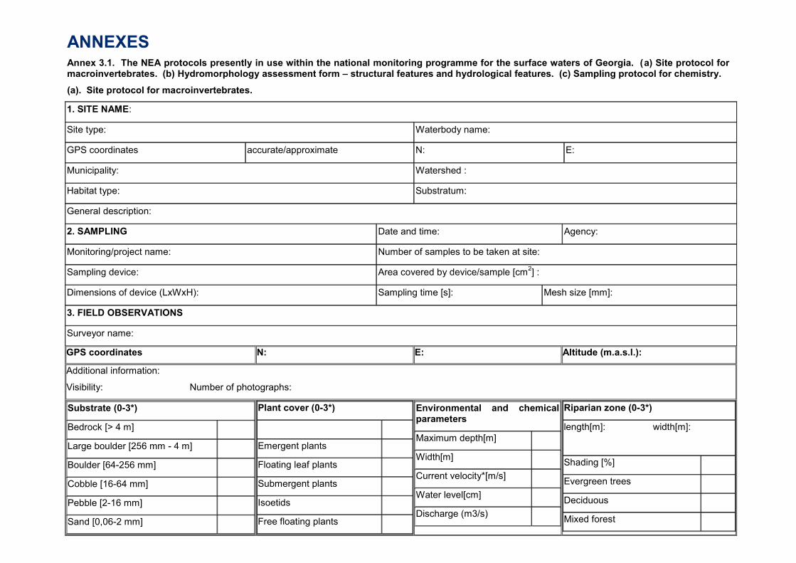
ANNEXES Annex 3.1. The NEA protocols presently in use within the national monitoring programme for the surface waters of Georgia. (a) Site protocol for macroinvertebrates. (b) Hydromorphology assessment form – structural features and hydrological features. (c) Sampling protocol for chemistry.
(a). Site protocol for macroinvertebrates.
1. SITE NAME:
Site type: Waterbody name:
GPS coordinates accurate/approximate N: E:
Municipality: Watershed :
Habitat type: Substratum:
General description:
2. SAMPLING Date and time: Agency:
Monitoring/project name: Number of samples to be taken at site:
Sampling device: Area covered by device/sample [cm2] :
Dimensions of device (LxWxH): Sampling time [s]: Mesh size [mm]:
3. FIELD OBSERVATIONS
Surveyor name:
GPS coordinates N: E: Altitude (m.a.s.l.):
Additional information:
Visibility: Number of photographs:
Substrate (0-3*)
Bedrock [> 4 m]
Large boulder [256 mm - 4 m]
Boulder [64-256 mm]
Cobble [16-64 mm]
Pebble [2-16 mm]
Sand [0,06-2 mm]
Plant cover (0-3*)
Emergent plants
Floating leaf plants
Submergent plants
Isoetids
Free floating plants
Environmental and chemical parameters
Maximum depth[m]
Width[m]
Current velocity*[m/s]
Water level[cm]
Discharge (m3/s)
Riparian zone (0-3*)
length[m]: width[m]:
Shading [%]
Evergreen trees
Deciduous
Mixed forest
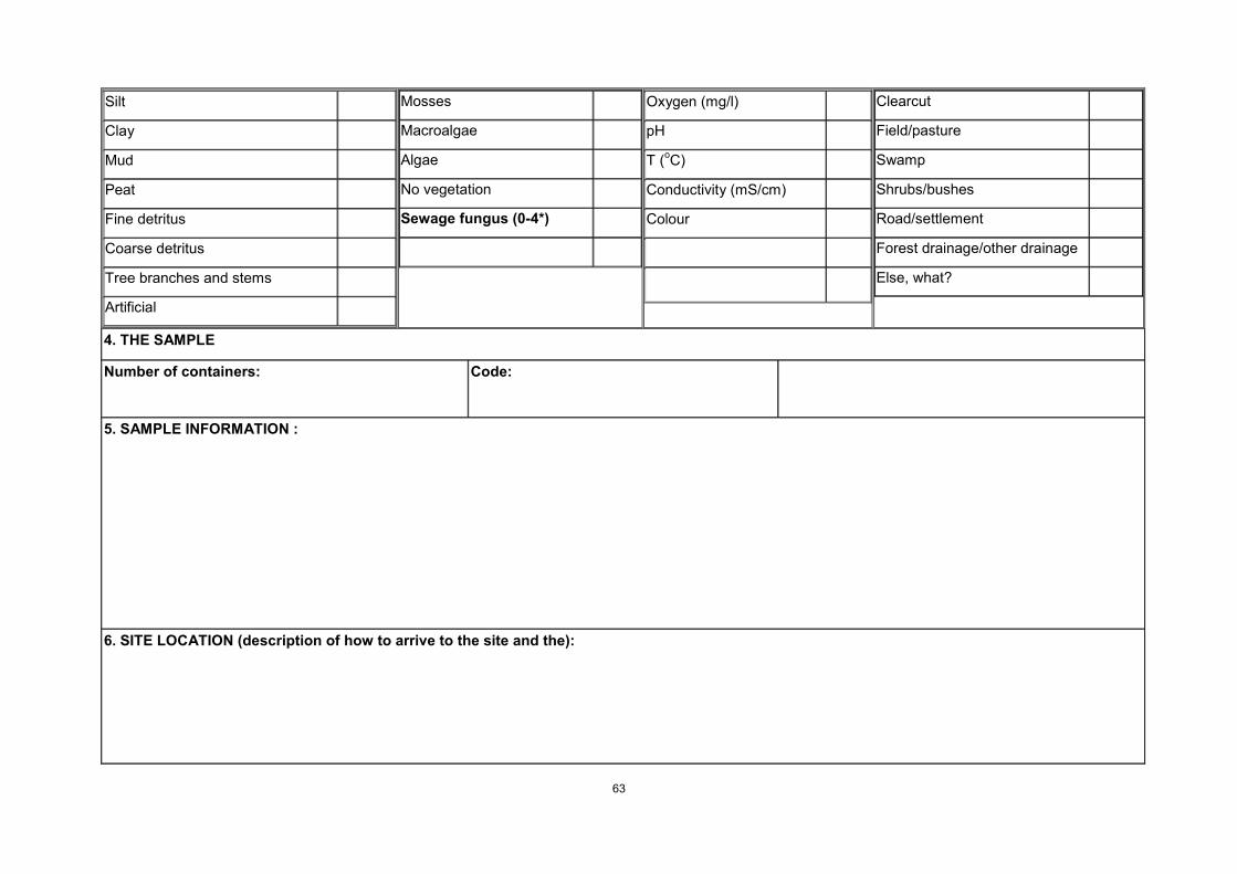
63
Silt
Clay
Mud
Peat
Fine detritus
Coarse detritus
Tree branches and stems
Artificial
Mosses
Macroalgae
Algae
No vegetation
Sewage fungus (0-4*)
Oxygen (mg/l)
pH
T (oC)
Conductivity (mS/cm)
Colour
Clearcut
Field/pasture
Swamp
Shrubs/bushes
Road/settlement
Forest drainage/other drainage
Else, what?
4. THE SAMPLE
Number of containers:
Code:
5. SAMPLE INFORMATION :
6. SITE LOCATION (description of how to arrive to the site and the):

64
7. HABITATS SAMPLED (photo of the sampling area):
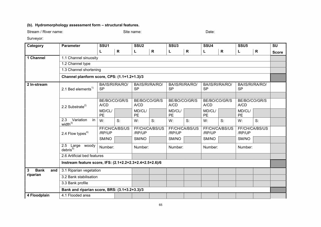
65
(b). Hydromorphology assessment form – structural features.
Stream / River name: Site name: Date:
Surveyor:
Category Parameter SSU1 SSU2 SSU3 SSU4 SSU5 SU
Score L R L R L R L R L R
1 Channel 1.1 Channel sinuosity
1.2 Channel type
1.3 Channel shortening
Channel planform score, CPS: (1.1+1.2+1.3)/3
2 In-stream
2.1 Bed elements1)
BA/IS/RI/RA/RO/SP
BA/IS/RI/RA/RO/SP
BA/IS/RI/RA/RO/SP
BA/IS/RI/RA/RO/SP
BA/IS/RI/RA/RO/SP
2.2 Substrate2)
BE/BO/CO/GR/SA/CD
BE/BO/CO/GR/SA/CD
BE/BO/CO/GR/SA/CD
BE/BO/CO/GR/SA/CD
BE/BO/CO/GR/SA/CD
MD/CL/PE
MD/CL/PE
MD/CL/PE
MD/CL/PE
MD/CL/PE
2.3 Variation in width
3)
W: S: W: S: W: S: W: S: W: S:
2.4 Flow types4)
FF/CH/CA/BS/US/RP/UP
FF/CH/CA/BS/US/RP/UP
FF/CH/CA/BS/US/RP/UP
FF/CH/CA/BS/US/RP/UP
FF/CH/CA/BS/US/RP/UP
SM/NO SM/NO SM/NO SM/NO SM/NO
2.5 Large woody debris
5)
Number: Number: Number: Number: Number:
2.6 Artificial bed features
Instream feature score, IFS: (2.1+2.2+2.3+2.4+2.5+2.6)/6
3 Bank and riparian
3.1 Riparian vegetation
3.2 Bank stabilisation
3.3 Bank profile
Bank and riparian score, BRS: (3.1+3.2+3.3)/3
4 Floodplain 4.1 Flooded area
66
4.2 Natural vegetation
Floodplain score, FPS: (4.1+4.2)/2
Hydromorphological Quality Score (CPS+IFS+BRS+FPS)/4
1) BA: Bars, IS: Islands, RI: Riffles, RA: Rapids, RO: Rocks, SP: Step/pools
2) BE: Bedrock, BO: Boulders, CO: Cobble, GR: Gravel, SA: Sand, CD: Coarse debris, MD: Mud/silt, CL: Clay, PE: Peat
3) Measure widest and smallest width in each SSU. Calculate variation in width overall smallest and widest width
4) FF: Freefall, CH: Chute, CA: Chaotic, BS: Broken standing waves, US: Unbroken standing waves, RP: Rippled, UP: Upwelling, SM: Smooth, NO: No perceptible flow
5) Count number of woody debris in all SSU and scale total number for the whole SU to numbers per km
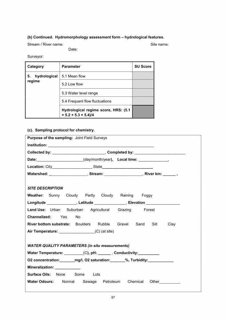
67
(b) Continued. Hydromorphology assessment form – hydrological features.
Stream / River name: Site name:
Date:
Surveyor:
Category Parameter SU Score
5. hydrological
regime
5.1 Mean flow
5.2 Low flow
5.3 Water level range
5.4 Frequent flow fluctuations
Hydrological regime score, HRS: (5.1
+ 5.2 + 5.3 + 5.4)/4
(c). Sampling protocol for chemistry.
Purpose of the sampling: Joint Field Surveys
Institution: __________________________________________________
Collected by: _________________________, Completed by: ________________________
Date:______________________(day/month/year), Local time: ______________,
Location: City___________________ State________________________
Watershed: __________________, Stream: __________________, River km: ______ ,
SITE DESCRIPTION
Weather: Sunny Cloudy Partly Cloudy Raining Foggy
Longitude ______________, Latitude _______________, Elevation ________________
Land Use: Urban Suburban Agricultural Grazing Forest
Channelized: Yes No
River bottom substrate: Boulders Rubble Gravel Sand Silt Clay
Air Temperature: _________________(C) (at site)
WATER QUALITY PARAMETERS (in situ measurements)
Water Temperature: _________(C), pH: ______ , Conductivity:__________
O2 concentration:_______mg/l, O2 saturation:_______%, Turbidity:____________
Mineralization: ____________
Surface Oils: None Some Lots
Water Odours: Normal Sewage Petroleum Chemical Other__________

68
Additional Notes: Document below any information or observations you made that are not
included on this form: _____________________________________________________
________________________________________________________________________