Embed Size (px)
Citation preview

EEENNNEEERRRGGGYYY,,, MMMIIINNNEEERRRAAALLLSSS &&& NNNAAATTTUUURRRAAALLL
RRREEESSSOOOUUURRRCCCEEESSS DDDEEEPPPAAARRRTTTMMMEEENNNTTT
MMMIIINNNIIINNNGGG AAANNNDDD MMMIIINNNEEERRRAAALLLSSS DDDIIIVVVIIISSSIIIOOONNN 111222222000 SSS... SSSTTT... FFFRRRAAANNNCCCIIISSS DDDRRRIIIVVVEEE
SSSAAANNNTTTAAA FFFEEE,,, NNNMMM 888777555000555
AAAUUUGGGUUUSSSTTT 222000111000
GGuuiiddaannccee DDooccuummeenntt ffoorr PPaarrtt 66 NNeeww MMiinniinngg OOppeerraattiioonn
PPeerrmmiittttiinngg UUnnddeerr tthhee NNeeww MMeexxiiccoo MMiinniinngg AAcctt

Mining Act Reclamation Program Page 1 August 2010
Mining and Minerals Division (MMD) Guidance Part 6: New Mining Operations – Sampling and Analysis Plan (Phase I) The New Mexico Mining Act and Rules require that an applicant for a new mining operation permit submit a Sampling and Analysis Plan (SAP) to the Director of MMD. The SAP is a detailed work plan that describes how baseline data (which is required for a Part 6 new mining operation) will be collected. It is critical that the SAP thoroughly describe the proposed sampling methodology and frequency, proposed data sources, and proposed sampling locations to document existing resource conditions within the permit boundary. The SAP should not present or include technical data such as vegetation survey results, results of cultural resource inventories, geologic cross-sections or maps, analytical data tables summarizing soil or groundwater data, etc.; the SAP is a work plan and should only describe how data will be collected for the Baseline Data Report (BDR; Phase II described in this guidance document). Inclusion of technical data should only be presented in the SAP to allow the reviewer enough information to envision and evaluate how a particular aspect of data collection will be completed. The SAP should be completed prior to the collection of any baseline data. Baseline data describes the hydrologic, geologic, mineralogy, ecologic, and cultural components within the proposed permit area and the area outside of the permit area that will be affected by the proposed mining activity. If baseline data is collected prior to the submittal of the SAP, the methodology used to collect the baseline data must be described in the SAP. The SAP must include a list of any new baseline data needing to be collected, and if appropriate, historic data. This guidance document addresses the methodology that will be used for data collection and analysis relevant to the proposed mining activities, herein defined as Phase I of the application process, and provides an overview of the information and components required for the permit application. Its intended use is to serve as a roadmap of the regulatory components in 19.10.6.602.D.(12) and (13) New Mexico Administrative Code (NMAC) that need to be included in a SAP. By following this Phase I guidance the user is directed to specific locations in 19.10.6.602 NMAC where the detailed requirements are given. The applicant should use this document as guidance only, and not as a replacement in examining specific and detailed requirements called out in 19.10.6.602 NMAC.
1.0 PHASE I - DEVELOPING A SAMPLING AND ANALYSIS PLAN The details and the amount of baseline data needed will depend on the size and scope of the mining operation. When submitting a SAP the following steps and components will need to be satisfied.
1.1 Submittal
Ultimately, the applicant must submit six copies (plus one electronic copy) of the proposed SAP, in accordance with 19.10.6.602.D.(12) NMAC prior to baseline data collection, which includes a general plan describing the information listed in the following sections. However, for the initial

Mining Act Reclamation Program Page 2 August 2010
submittal of the SAP, MMD may allow only one copy to be submitted. After review and comments, MMD will then require the remaining copies be submitted for distribution to other interested parties.
1.2 Applicant Information/General Plan The SAP must include a general plan which will contain the specified components and information outlined in 19.10.6.602.D.(1-6), (9), and (11) NMAC including: Name of permit applicant A map of the proposed permit area (on a USGS topographic map) A map showing all known surface owners of surface and mineral estates within the proposed
permit area A list, including names and addresses, of all known owners of surface and mineral estates within
the proposed permit area (use recent county assessor’s property tax schedule) A general plan for mining including the commodity (or commodities) to be mined, the proposed
number and location of pits, shafts, adits, vent holes, waste piles, stockpiles, buildings and other facility infrastructure, and the proposed location of project features and areas to be used for baseline data collection
Documents evidencing the applicant’s right to enter the proposed permit area and conduct mining and reclamation
A list of all parties, including addresses and telephone numbers, that have an ownership and controlling interest in the operation
A statement of all mining operations with the United States owned, operated or directly controlled by the applicant, owner or operator
The contact information for the applicant’s designated agent
1.3 Permit Fees The permit fee will be submitted to MMD at the time the general plan and proposed SAP package is submitted. The fee structure is based on the size and type of operation. The fee structure is given in 19.10.2.201.B and 19.10.2.203.B NMAC. At the time the SAP is submitted only the base fee of $5,000.00 is required to be submitted. The remainder of the fees will be due with submittal of the PAP outlined in Phase II of this document.
1.4 SAP Categories for Resources Required to be Characterized Through Sampling Several of the resource categories that must be addressed and discussed in the SAP require extensive sampling in order to adequately prepare a baseline data sampling report. Pursuant to 19.10.6.602.D.(13) NMAC the SAP document must contain separate sections for the following data categories:
Climatological factors * *Climatological factors may need to be sampled on-site only if nearby, relevant

Mining Act Reclamation Program Page 3 August 2010
Weather station &
topographic map
weather stations are not available or are not representative of the proposed permit area. See Section 1.6 of this guidance document for additional information.
Vegetation survey Wildlife survey Topsoil survey/sampling Geologic sampling **
** Geologic sampling and analysis may be required if the substrata is suspected to contain substances that are likely to create acid drainage or might degrade surface water or ground water or hinder reclamation.
Surface water sampling Ground water sampling Radiological survey (for uranium, or other radiological element, mining operations only) Historic and cultural properties survey
Each of these resource categories, except for the historic and cultural properties survey category, will need additional information in the SAP pursuant to the sub-categories listed below in Section 1.4.1.
1.4.1 SAP Sub-Categories for Resources Required to be Characterized Through Sampling
For each of the resource categories listed above in Section 1.4, except for the historic and cultural properties survey category (unless a sampling survey is proposed to and approved by the Historic Preservation Division of the Department of Cultural Affairs), the following information must be presented in sub-categories pursuant to 19.10.6.602.D.(12).(a) NMAC: Sampling objectives Parameters to be analyzed (see Table 1) Sampling frequency (see Table 2) Maps showing proposed sampling locations A list of data to be collected Laboratory and field quality assurance plans Methods of collection A brief discussion supporting the proposals
Table 1 below describes the sampling content of several of the SAP categories. The content below is for guidance only; not all topics may apply to an individual mine site. Conversely, some additional content may be required dependent on the characteristics of the proposed project.

Mining Act Reclamation Program Page 4 August 2010
Table 1 – Suggested Sampling/Survey Content
SAP Category Suggested Survey or Sampling Content
Vegetation Survey Proposed sampling content should include plant inventory, vegetation mapping, foliage or basal cover, diversity of plant life form, productivity, and woody plant density, floral threatened and endangered species survey.
Wildlife Survey Proposed sampling content should include pellet counts, bird diversity studies, wildlife sightings, relative abundance, distribution by habitat and season, key habitat areas observed, threatened and endangered species survey.
Topsoil Characterization
Proposed sampling content should address soil characterization to determine the suitability and approximate volume of material available for reclamation substrates. Parameters for sampling should include soil thicknesses, paste pH, electrical conductivity, saturation percentage, particle size distribution, sodium adsorption ratio (SAR), selenium, boron, acid/base potential, rock fragment percentage, nitrate-nitrite, phosphorus, potassium, iron, magnesium, manganese, copper, cadmium, lead, mercury, molybdenum, nickel, and arsenic. In most cases, an Order 1 soil survey in areas proposed for disturbance will likely be required to sufficiently estimate the mass balance between on-site soils and the volume needed for reclamation. If insufficient soil volume is available on-site, any proposed off-site borrow areas should be also included in the Order 1 soil survey, as well as laboratory analysis of the soil from the proposed borrow areas.
Geologic Sampling
Sampling may be needed to address the potential for geologic strata to create acid drainage, or degradation of surface water and/or ground water, or cause a hindrance to reclamation. Synthetic Precipitation Leaching Procedure (SPLP) analysis of waste rock, overburden, mineralized zones, stockpiles, sub-economic zones or piles, etc. should be utilized. Parameters of interest may include metals such as aluminum, antimony, arsenic, barium, beryllium, boron, cadmium, calcium, chromium, cobalt, copper, iron, lead, magnesium, manganese, total mercury, molybdenum, nickel, potassium, selenium, silver, sodium, thallium, uranium, vanadium, and zinc. Other analyses of interest may include sulfate, sulfide, pH, acid-base accounting, gross alpha, gross beta and photon, radium-226+228, and radon-222.
Surface Water and Ground Water Sampling
Proposed sampling content should address how the sampling will be conducted, equipment to be used and proposed locations. Surface water quality and quantity is anticipated to be addressed through opportunistic sampling and flow measurements for ephemeral streams. Surface and ground water parameters to be analyzed may include alkalinity-bicarbonate, aluminum, antimony, arsenic, barium, beryllium, boron, cadmium, calcium, chloride, chromium, cobalt, copper, cyanide, fluoride, iron, lead, magnesium, manganese, total mercury, molybdenum, nickel, nitrate-nitrite, potassium, selenium, silver, specific conductance (field measured), sodium, sulfate, temperature (field measured), total dissolved solids, turbidity, zinc, and pH (field measured). For uranium mines, the sampling may also include: uranium, thallium, gross alpha, gross beta and photon, radium-226+228, and radon-222. For ground water sampling, dissolved concentrations of

Mining Act Reclamation Program Page 5 August 2010
metals, except for total mercury, should be analyzed rather than total concentrations. Sediment sampling for surface water courses may be proposed in lieu of opportunistic water sample collection in certain circumstances. Parameters to be analyzed may include paste pH, electrical conductivity, saturation percentage, particle size distribution, rock fragment, arsenic, barium, cadmium, chromium, cobalt, copper, lead, manganese, mercury, molybdenum, nickel, turbidity, selenium, silver and zinc. For uranium or other radioactive element mining, sediment may also be analyzed for uranium, thallium, gross alpha, gross beta and radium-226+228.
Historic and Cultural Properties Survey
The proposed scope of work must include all sites, all known cemeteries and human burials and artifacts identified during a 100% walking survey.
Radiological Survey (uranium or other
radioactive element mining operations only)
The proposed scope of work for the radiological survey should provide a baseline for radiochemical content and include a gamma-survey of the primary permit areas such as roads and facility locations as well as potential downstream affected areas. Bulk soil samples should be proposed for collection to verify field readings for analysis of uranium (total-238), radium 226, radium 228, thorium (total-232) and gross alpha/beta.
Table 2 below describes sampling or survey frequency to be included in the SAP for a new mining operation. The frequencies described below are for guidance only. Additional sampling or less frequent sampling may be appropriate dependent on the site-specific characteristics of the proposed project.
Table 2 – Suggested Sampling/Survey Frequency
SAP Category Suggested Sampling or Survey Frequency
Vegetation Survey The SAP should propose a minimum of two surveys over a 12 month period; once in the spring, once in late summer.
Wildlife Survey The proposed scope should include a minimum of two surveys over a 12 month period; once in December or January for overwintering bird species, once in late-May to early June for peak breeding season.
Topsoil Characterization The SAP should propose at least one sampling event during the 12 month period.
Surface Water Sampling The SAP should propose a minimum of four sampling events over the 12 month period (quarterly) for perennial streams; four opportunistic sampling events after storm activity for ephemeral streams.
Ground Water Sampling The SAP should propose a minimum of two sampling events over the 12 month period (semi-annually).
Historic and Cultural Properties Survey
The proposed scope should include a minimum of one survey within a 12 month period.

Mining Act Reclamation Program Page 6 August 2010
Radiological Survey (uranium or other radioactive element mining
operations only)
The SAP should propose a minimum of one sampling event during the 12 month period.
1.5 Other SAP Categories The SAP must also include the following categories and information in order to evaluate the appropriateness of the proposed sampling:
Climatological factors : Describe in the SAP the methods through which climatological factors will be obtained. If nearby, relevant weather stations are available, the SAP must propose which weather station(s) the data will be obtained from, the types of equipment present on the weather station(s), and must include a map showing the location(s) of the weather station(s) relative to the proposed permit area. If no nearby, representative weather stations are available for use, site-specific climate data will be required to be collected over the 12-month baseline sampling period through the installation of an on-site weather station. The equipment proposed for collection of the site-specific climate data must be included with the SAP. Data for the following climate factors should be proposed in the SAP:
o Wind direction o Relative humidity o Wind speed o Barometric pressure o Temperature o Solar radiation (if available) o Precipitation
Topographic maps : Topographic maps included within the SAP must be at a scale of 1 inch
equals 2,000 feet (1:24,000) or at a scale pre-approved by MMD and must accurately represent the proposed permit and potentially affected area. The topographic maps for the SAP should include a conceptual mine layout to show the basics of the proposed mining operation. The conceptual mine layout figure must include the proposed locations of all surface features such as structures, stockpiles, tailings, pits, adits, shafts, etc. The topographic maps in the SAP must also show the proposed sampling locations for soil characterization analysis, surface water features, ground water wells, climate data, and wildlife and vegetation transects. For uranium mines, the area proposed for the baseline radiological survey should also be indicated on a topographic map.
Mine Operation & Reclamation Plan Description : In order to evaluate the scope of sampling proposed under the SAP, MMD will need to understand the general layout and engineering, mining, and reclamation methods proposed for the operation. As such, the SAP must include a general description of the mine operation and reclamation plan as it relates to the conceptual mine layout discussed above including the number of proposed pits, adits, shafts, vent holes, waste piles, stockpiles, and facilities.

Mining Act Reclamation Program Page 7 August 2010
General Geology and Ore Body Description : Describe in the SAP the general geology of the area, the anticipated stratigraphy, the commodity to be mined, and a description of the ore body (depth, mineralized zones projects to the surface, etc.) and any substrata likely to create acid mine drainage or that might degrade surface water or ground water resources. The SAP should describe the proposed source(s) of geologic information such as USGS reports, on-site exploratory borehole data, etc.
Surface Water and Ground Water Information : The SAP must include general surface water information such as the location of watercourses, lakes, springs, riparian and wetland areas, ephemeral, intermittent or perennial streams that any surface water discharge from the mining operations could impact, as well as the boundary of the watershed in which the proposed mining operation is proposed. The SAP must also include general ground water aquifer information such as anticipated local and regional ground water aquifers as well as the anticipated depths to ground water. If mine dewatering is required, the SAP must also address whether a pump test or other aquifer testing is needed to better characterize the potential impact to both surface water (i.e. quantity and quality of discharged water) and ground water (i.e. cone of depression, potential impacts to users, alteration of the regional ground water flow direction).
Soils Information : The SAP should include a brief description of the existing soil types
within the permit area, and a description of the proposed source(s) of additional soil information such as USDA soil survey maps, historic soil mapping performed within the proposed project area, etc. If required, the SAP should describe, in detail, the methodology through which an Order 1 soil survey will be completed (i.e. backhoe test pit locations, anticipated depths, etc.) and the locations proposed for completion of an Order 1 survey.
Land Use Information : The SAP must include a description of how land uses within the
proposed project area and surrounding area will be determined (i.e. county assessors records, interviews, BLM land-use maps, etc.). The SAP must describe how the delineation of any prior mining operations which may have affected the permit area will be accomplished and where this information will likely be obtained (i.e. records review, historic aerial photo review, etc.).
1.6 Identify Data Sources to be Used During Data Collection The SAP must identify the source or sources of data to be collected or utilized for the baseline data categories indentified in 19.10.6.602.D.(13) NMAC. The SAP will include:
Appropriate and currently available data and information (referenced herein as ‘historic’ data) that will be used in the baseline data report at the time of the permit application
Data deficiencies that are currently not covered by historic data and will therefore be required to be collected for production of the baseline data summary report

Mining Act Reclamation Program Page 8 August 2010
Vegetation growth post
reclamation
If historic data and information are used as part of the baseline data, the SAP will include supporting material justifying the use of this historic data. Historic data, if used, will be included as part of the baseline data. Historic data can be data or information collected by other agencies or individuals not related to the applicants mining activities (e.g., NOAA, USGS, BLM data).
1.7 Geographic Information System (GIS) Data for SAP
The SAP must also identify data which will be collected using Global Positioning System (GPS) techniques such as the permit boundary, discrete sampling locations, transect locations, surface drainage features, weather station locations, cultural resource locations, etc. Tabulation of the GPS location information will be required to be presented in the baseline summary report in both hard-copy and digital formats (Microsoft Excel spreadsheet of survey data, .shp file compatible with ArcGIS, etc.).
2.0 PHASE I – INITIAL AND TECHNICAL REVIEW
2.1 Initial Review of SAP The SAP will be initially reviewed by MMD and distributed to other reviewing agencies within 20 days after receipt. MMD may perform a press release on the application.
2.3 Agency and Tribal Consultation Within 20 days of receipt of the SAP, MMD will distribute copies of the proposed SAP for agency and tribal review and comments. The agency and tribal comment and review period is 30-days. MMD will deliver copies of the SAP to the following agencies: NM Environment Department Office of the State Engineer NM Department of Game and Fish State Forestry Division State Historic Preservation Office
Any federal agency involved with the operation permit area (i.e., Bureau of Land Management, US Forest Service, etc.)
Other agency (or agencies) and tribes deemed appropriate by the Director
2.4 Technical Review
After the 30-day review period by the agencies and tribes described above in Section 2.3, MMD will conclude a technical review of the SAP, and consolidation of agency comments, within a second 30-day period. After MMD has collected agency and tribal reviews/comments, a letter will be sent to

Mining Act Reclamation Program Page 9 August 2010
the operator within this 30-day period regarding the adequacy of the SAP that also summarizes MMD comments and other agency/tribal comments. The applicant may also request a conference with MMD to discuss various technical aspects of the SAP. MMD may require a phased sampling approach where results of initial sampling will dictate locations and protocol for later sampling. For example, the results of initial water monitoring wells may dictate the need and location of additional water monitoring wells for more complete baseline data collection. Pursuant to 19.10.6.602.D.(14) NMAC the Director may request that the applicant pay for a third party reviewer to review and comment on the adequacy of the SAP and baseline data prior to the submittal of the permit application. A flowchart depicting the Phase I process is on the following page.

Mining Act Reclamation Program Page 10 August 2010
Part 6: New Mine Operations Phase I – Sampling & Analysis Plan Flowchart
Items prepared and submitted by applicant: Sampling & Analysis Plan (SAP) [19.10.6.602.D.(12) NMAC]
o 6 copies, plus 1 electronic copy
General Plan [19.10.6.602.D.(1-6), (9) and (11) NMAC] within the SAP to include: o Commodity to be mined o Proposed number of pits, shafts, adits, vent holes, waste piles, stockpiles, facilities, etc. o Location of project features and areas to be used for baseline data collection
$5,000 permit fee [19.10.2.201.B.(1) NMAC]
Initial SAP and General Plan review by MMD (and/or MMD’s third party consultant; within 20 days of receipt of the SAP it
will be sent to other reviewing agencies.
Possible issuance of press release by MMD
Comments submitted to MMD
MMD distribution of SAP to Agencies and Tribes for review and comments
(1st 30-day comment period)
MMD technical review of SAP, and consolidation of comments
(2nd 30-day period)
Applicant can commence baseline data collection (12-month period)
SAP comment letter sent to applicant

Mining Act Reclamation Program Page 11 August 2010
Mining and Minerals Division (MMD) Guidance Part 6: New Mining Operations – Permit Application Package (Phase II)
The New Mexico Mining Act and Rules requires that an applicant for a new mining operation permit submit a permit application pursuant to the requirements of 19.10.6.602 of the New Mexico Administrative Code (NMAC). There are two phases to submitting a permit application. The first phase is providing the Sampling and Analysis Plan (SAP) (Phase I), and the second phase is the submittal of the entire Permit Application Package (PAP) (Phase II), to the Director of MMD. This guidance document addresses Phase II of the application process and provides an overview of the information and components required for the permit application. Its intended use is to serve as a roadmap of the regulatory components in 19.10.6.602 NMAC (referred to as Part 6) needing to be included in a PAP. By following this Phase II guidance the user is directed to specific locations in 19.10.6.602 NMAC where the detailed requirements are given. The applicant should use this document as guidance only, and not as a replacement in examining the specific and detailed requirements called out in 19.10.6.602 NMAC.
1.0 PHASE II - DEVELOPING THE PERMIT APPLICATION PACKAGE A complete PAP will be submitted to the Director of MMD. The PAP consists of four documents:
1.) A copy of the SAP that was implemented for completion of baseline sampling This is for the reviewer’s information only regarding sampling methodology and
proposed scope of work for comparison to the BDR. No additional agency comments will be made on the SAP during administrative or technical review of the PAP.
2.) Baseline Data Report (BDR)
3.) Mining Operation and Reclamation Plan (MORP) 4.) Environmental Evaluation (EE; will be completed by MMD) The PAP will include a Baseline Data Report (BDR) that has been collected under and satisfies all components pursuant to 19.10.6.602.D.(12) and (13) NMAC. Phase I provided guidance of those
Reclamation site control and signage

Mining Act Reclamation Program Page 12 August 2010
components needing to be included in the SAP. The baseline data collection process will follow the applicant’s SAP that was previously deemed adequate by the Director prior to data collection (see guidance document for Phase I). The time-span for data collection for evaluation of water quality and quantity, wildlife and wildlife habitat and vegetation will be at least 12 months (pursuant to 19.10.6.602.D.(13) NMAC). In addition to the BDR, the PAP will include the SAP and all elements described in 19.10.6.602.A through D.(1) through (11) NMAC, 19.10.6.602.D.(15) NMAC [Mining Operation and Reclamation Plan], and 19.10.6.603 NMAC [Performance and Reclamation Standards and Requirements; related to the Mining Operation and Reclamation Plan].
1.1 Submittals
1.1.1 Draft of Public Notice
Prior to submittal of the PAP, the applicant should submit a draft of the public notice language required by 19.10.9.902 and 19.10.9.903 NMAC to MMD for review and approval.
1.1.2 Public Notice and Mailing of Notice
Once the language of the draft public notice is approved by MMD, the public notice must be:
Published in a newspaper, in both English and Spanish, of general circulation in each county in which the proposed property is located (classified section or legal advertisements section), and at one other place in the newspaper calculated to give the general public the most effective notice
Posted in at least four publically accessible and conspicuous places on or before the newspaper publication date
Provided by certified mail to: o The owners of record o All properties within ½ mile of the proposed property o All municipalities, counties, and tribal organizations within a 10 mile radius
of the proposed property o The mineral lessor, if any o All persons on a list maintained by MMD of individuals and organization who
have requested notice of application under the Act o The New Mexico Environment Department o The Office of the State Engineer o The Department of Game and Fish o The State Forestry Division o The State Historic Preservation Division
Once published by the applicant, the public will have 30-days to comment and/or request a public hearing. Proof that the public has been notified according to the items above are required to be submitted in the PAP. Example of proof includes notarized affidavits of publication from the newspapers, copies of return receipts from the postal service, photographs of the notices posted in conspicuous places, etc.
Mining Act Reclamation Program Page 13 August 2010
1.1.3 Initial Application and Copies
The applicant is ultimately required to submit six (6) copies of the completed PAP and one (1) additional copy if the proposed operation is located on federal or state land in accordance with 19.10.6.602.A NMAC. However, for the initial submittal of the PAP, MMD may allow only one copy to be submitted. When the PAP is deemed “administratively complete,” MMD will then require the remaining copies be submitted. The following sections describe necessary components that need to be included in the PAP in accordance with 19.10.6.602.A NMAC.
1.1.4 Confidential Information
Information designated to be confidential by the applicant should be submitted with the PAP in a separate package. Confidentiality shall be maintained in accordance with the requirements outlined in 19.10.4.402.B NMAC. Information designated to be confidential should be clearly marked as such. If a request is made for public review of the information designated by the operator to be confidential, the Director of MMD will notify the operator and provide a reasonable opportunity for substantiation of the claim that public disclosure of the information could harm the competitive position of the operator. If the claim of confidentiality is not substantiated to the satisfaction of the Director, the information will be released. When a request is made to review confidential information, the Director will attempt to notify the operator within 24 hours of the request and will provide written notification by certified mail.
1.2 Permit Fees Structure The base fee of $5,000.00 should have been submitted with submittal of the SAP (Phase I of this guidance document). The remainder of the permit fees will be submitted to the Director at the time the PAP is submitted. The fee structure is based on the size and type of operation, and is given in 19.10.2.201.B and 19.10.2.203.B NMAC.
Fees for a New Mine pursuant to 19.10.2.201.B NMAC: The remainder of the permit application fee for a new mining operation shall be determined as follows:
o $200.00 per acre for the first 50 acres of land expected to be disturbed over the life of the
mine (design limits) for surface disturbance, plus o $40.00 per acre for all such land over 50 acres
Pursuant to 19.10.2.203.B NMAC the applicant will also submit facility fees based on the
type and size of facility operations listed in the attendant table of 19.10.2.203.B NMAC.
1.3 Permit Application Organization and Formatting

Mining Act Reclamation Program Page 14 August 2010
Include a table of contents which cross-references the applicable regulations found in 19.10.6 and 19.10.9 NMAC (Parts 6 and 9). The following provides a general outline for formatting the table of contents:
o Summary, background and project overview o Applicant information o Public notification information (copies of return receipts, affidavits of publication, etc.) o Copy of the SAP that was implemented for baseline data collection (from Phase I; for
reviewer’s informational purposes only). o Baseline Data Report (BDR) o Mining Operation and Reclamation Plan (MORP) and performance standards o List of tables o List of figures o List of appendices and reports
Format and label all sections of the PAP to correspond to the applicable Rules Format the PAP so that revisions, modifications and other new material can easily and
logically be inserted. This is especially important for design data and maps for impoundments, diversions and roads
All narrative and forms in the PAP should be paginated and all plans, designs, drawings, etc. should have exhibit or figure numbers in logical sequence
The narrative in each section should refer to all applicable exhibits or appendices Format the BDR so that all baseline data sections are in stand-alone chapters that will require
little or no updating on future re-review Place the month, day and year that each page was generated at the bottom of each page (i.e.
08/27/09) Provide a digital copy of the entire PAP in post driver script format (.pdf), which includes all
sections of the application (figures, appendices, reports, etc.)
1.4 Applicant Information Pursuant to 19.10.6.602.D.(1) through (11) NMAC, each PAP shall include the preliminary information relevant to the applicant and permit area. A brief description of these requirements is provided below:
Name of applicant Map of permit area Documents evidencing right to enter and right to mine, right to reclaim Addresses of parties with ownerships and controlling interest, including the applicants most
recent 10K form required by the United States Securities and Exchange Commission A statement of all mining operations within the United States owned, operated or directly
controlled by the applicant, owner or operator and by persons or entities that directly control the applicant and the names and addresses of regulatory agencies with jurisdiction over the environmental aspects of those operations and that could provide a compliance history for those operations over the preceding 10 years

Mining Act Reclamation Program Page 15 August 2010
The designated agent with current and full street address Information from other governmental agency’s environmental permits, relevant to the
application that satisfy the requirements of the Act and 19.10 NMAC A listing of all federal and state permits required for the operation A copy of the proposed public notices required under 19.10.9 NMAC
1.5 Baseline Data Report (BDR) Once the SAP has been implemented, the resulting data is described and summarized in the Baseline Data Report (BDR). Baseline data collected pursuant to 19.10.6.602.D.(13) NMAC and as described in the SAP, should be summarized and provided in a report to be submitted as one of the documents required for the PAP. Topics to be addressed in the BDR include:
Climatological Results : The BDR must present climatological data accumulated through the compilation of data from nearby, relevant weather stations or from a site-specific weather station installed within the proposed mining operation permit boundary.
Topographic Maps : Topographic maps in the BDR, must include the boundaries of the
permit area, the location of all buildings within a ½ mile radius of the permit area, a legend for the symbols that occur on the USGS topographic map, all man-made features within the permit area existing on the date of application. All maps must be at a scale of 1 inch equals 2,000 feet (1:24,000) unless otherwise approved by MMD.
Vegetation Survey Results : The BDR is to include the results of the site-specific vegetation
survey and must include a map delineating the existing vegetation types and a description, including cover, density and productivity of the plant communities. Include in the description the results of the inventory conducted for any sensitive, threatened or endangered species within the permit area. Include a complete copy of the vegetation survey report as an appendix in the baseline data summary report.
Wildlife Survey Results : The results of the wildlife survey must be described in the BDR and must include a map showing habitat types and the location(s) of special or unique wildlife habitat features such as cliffs, talus slopes, ponds, springs, known nests, etc. The results must include a list of species potentially occurring within the permit area and any additional species potentially impacted by the mining operation, as well as the legal status of each species. Any species confirmed to be present through direct or in-direct observation within the permit area must also be listed.
Topsoil Sampling Results : The results of any topsoil sampling, including soil thicknesses
and calculations of mass balance from an Order 1 survey, must be included in the BDR.
Geology and Ore Body Characterization : The BDR must include geologic plans and cross-sections depicting the nature and depth of the overburden, mineralized zone or ore body, aquifers and springs, and a description of the potential for geochemical alteration of

Mining Act Reclamation Program Page 16 August 2010
overburden, ore body and other materials that are likely to create acid drainage or might degrade surface water or ground water or hinder reclamation.
Surface Water and Ground Water Information : The BDR must include maps of surface water features, a description of the surface drainage systems and results of sampling sufficient to identify the seasonal variations in surface water quality and quantity, the lithology and thickness of each geologic unit below the site with an indication of which layers are water bearing, cross sections and potentiometric surface maps indicating the location of wells and the ground water flow direction in the vicinity of the site. References or sources of this information must be documented. The BDR must also include the results of sampling performed, and aquifer characteristics such as total dissolved solids concentrations, depths to water, direction of flow and gradients, transmissivity and storativity values, and a discussion on general water quality. The BDR must also make a determination of the probably hydrologic consequences of the operation and reclamation, on both the permit and affected areas, with respect to the hydrologic regime, quantity and quality of surface and ground water systems that may be affected by the proposed operations, including the dissolved and suspended solids under seasonal flow conditions.
Prior Mining Operations : The BDR must include a description and delineation on a topographic map of any prior mining operations which may have affected the permit area including, if known, the type of mining and processing method and a list of any processing chemical or reagents used.
Cultural Resources Survey Results : The BDR must include a description of the results of the cultural resources survey. A complete copy of the cultural resources survey report must be included as an appendix in the baseline data report.
Land Use : The BDR must summarize the present and historic land use(s) of the permit area, the general patterns of land use in the surrounding areas, and a narrative of land capability and productivity based upon United States Soil Conservation Service land use capability classes or a similar classification.
1.5.1 Geographic Information System (GIS) Data
Baseline data points including discrete sampling locations, surface features, cultural resource locations, transect locations, reference areas (see Section 1.6.2 below) and other location information must be presented with the baseline data summary report in both hard-copy (table compilation) and digital formats. For the digital format submittal, MMD requires that the data be submitted as a shape file (.shp) compatible with ERSI ArcGIS on a compact disc (CD).

Mining Act Reclamation Program Page 17 August 2010
1.6 Mining Operation and Reclamation Plan (MORP)
1.6.1 Mining Operation Description Pursuant to 19.10.6.602.D.(15) NMAC, the applicant must provide a detailed description of the mining operation, and a description of how the operation will meet the performance and reclamation standards and requirements pursuant to 19.10.6.603 NMAC. Information for the mining operation portion will include, but not be limited to, the following:
A description of the commodity to be mined, the type and method of mining, and the
engineering techniques proposed A map or maps at a scale approved by the Director and an approximate schedule or
timetable indicating the mining operations including number of acres of land to be disturbed
Maps and plans indicating the location, size and capacities for the mine facilities including: o Leach pads, heaps, ore dumps and
stockpiles o Mills o Other facilities or structures
o Impoundments o Water treatment facilities o Ponds o Diversions
o Storage areas for equipment, vehicles, chemicals and solutions
o Disposal systems o Topsoil and topdressing stockpiles o Pits o Tailings disposal facilities
o Waste rock dumps
A contingency plan to mitigate impacts to wildlife when there has been an emergency
or accidental discharge of toxic substances that may impact wildlife A description of measures which will be undertaken to reduce sedimentation from the
permit area and a plan for the monitoring of non-point source sediment pollution from the disturbed area
If post-mining land use if proposed, a detailed description of how the disturbed area will be reclaimed to achieve that use and written approval of the surface owner for the proposed use
The following performance standards (pursuant to 19.10.6.603 NMAC) should be addressed for development and operation of the mine:
o Most appropriate technology and best management practices: Description and
demonstration (i.e. comparison of available technologies; technological feasibility) that the most appropriate technology will be used during operation of the mine and a description of what best management practices will be utilized during operation

Mining Act Reclamation Program Page 18 August 2010
o Contemporaneous reclamation during operation: Description of the how proposed operational aspects of the mine will contribute to efforts to facilitate contemporaneous reclamation (mine-for-closure concept)
o Assure protection of human health and safety, the environment, wildlife and
domestic animals: Description of signs, markers and safeguarding to be used during operation
o Wildlife protection: Methods to be employed to restrict access of wildlife and
domestic animals during operation
o Cultural resources: Methods to be employed to protect cultural resources during operation
o Hydrologic balance: Description of how the operation will be planned and
conducted to minimize changes to the hydrologic balance in the permit area and potentially affected areas
o Stream diversions: Description of how stream channel diversions will be
designed, constructed and removed during operation
o Impoundments: Description of how impoundments will be designed, constructed and maintained during operation
o Minimization of mass movement: Description of methods to be used during
operation to minimize mass movement of waste dumps, topsoil, stockpiles and ore piles; included with this item are best management practices related to erosion control
o Riparian and wetland areas: Methods to be employed to minimize disturbance to
these areas during operation
o Roads: Methods to be employed during operation, construction and maintenance to minimize erosion from roads
o Subsidence control: Description of methods to be employed to minimize
subsidence in underground and in-situ solution mining, methods to avoid/prevent aquifer disruption and consequent exchange of ground water between the aquifer and other strata, methods to avoid/prevent material damage to streams and other bodies of water
o Explosives: Description of how adverse effects from blasting will be minimized
during operation

Mining Act Reclamation Program Page 19 August 2010
Reclaiming a
mine site
o Site stabilization & configuration: Description of how the permit area will be stabilized to the maximum extent practicable to minimize future impacts
o Preservation of topsoil: Description of how the operation will preserve and store
topsoil, where present and excavated within the permit area, for potential future use during reclamation, description of operation techniques to prevent the mixing of topsoil with other excavated materials to prevent loss of the resource, description of any sampling or testing to determine suitability for use as topdressing during reclamation
o Design of operation to avoid perpetual care: description of how the operation will be implemented to meet all environmental requirements of the Act, 19.10 NMAC and other laws and contribute to the ability to reclaim the area in the future without the need for perpetual care
1.6.2 Reclamation Plan Description
The PAP must include a reclamation plan consisting, at a minimum, of the following:
A detailed description of how the
disturbed area will be reclaimed to meet the performance requirements of 19.6.603 NMAC. The following performance standards should be addressed in the reclamation plan:
o Most appropriate technology
and best management practices: Comparison of currently available reclamation strategies. Each reclamation alternative should be evaluated based on site-specific technical feasibility, economic feasibility and environmental soundness. The reclamation plan should then propose a specific reclamation strategy to be employed based on these evaluation criteria, description of best management practices to be implemented during reclamation, description of how the proposed reclamation strategy will minimize mass movement of constructed piles
o Contemporaneous reclamation: Description of the how reclamation will be performed contemporaneously with mine operation (mine-for-closure concept)
o Assure protection of human health and safety, the environment, wildlife and
domestic animals, cultural resources, hydrologic balance, riparian and wetland areas: description of proposed measures to be implemented to safeguard the site

Mining Act Reclamation Program Page 20 August 2010
Erosion
Control
during reclamation, description of how the proposed reclamation technology will result in a hydrologic balance similar to pre-mining conditions (unless non-mining impacts have substantially changed the hydrologic balance)
o Stream diversions: Description of how stream channel diversions will be
reclaimed
o Subsidence control: Methods proposed to reclaim surface subsidence caused by underground or in-situ mining, methods proposed during reclamation to prevent future subsidence
o Roads: Identification of any roads proposed to be left unreclaimed consistent with
the approved post-mining land use and as approved by the surface owner
o Site stabilization & configuration: Description of how the proposed reclamation strategy will stabilize the permit area to the maximum extent practicable
o Preservation/use of topsoil: Description of any sampling or testing required to demonstrate suitability for use as topdressing during reclamation, description of how any topsoil determined to be suitable for reclamation will be utilized during reclamation activities, description of techniques to be implemented to stabilize areas applied with after distribution to protect the loss of the resource
o Erosion Control: Description of methods to be employed to control erosion of reclaimed disturbed lands to prevent contribution of suspended solids to streams or other bodies of water. Methods include, but are not limited to, land shaping, berming, grading to final contour; minimization of gradients; diverting runoff; establishing vegetation; regulation of water channel velocity; lining drainage channels with rock, vegetation or other geotechnical materials; and mulching
o Revegetation: Description of proposed revegetation techniques that will be employed to obtain a self-sustaining ecosystem based on defined reference areas to obtain: Foliage or basal cover and productivity of plants of the revegetated area to
90% of the reference area or within a 90% statistical confidence Diversity of plant forms (woody plants, grasses, forbs) relative to the
physical environment of the area to be reclaimed Establishment of woody plants to obtain the approved density with an
80% statistical confidence

Mining Act Reclamation Program Page 21 August 2010
For areas with an approved post-mining land use of wildlife habitat or forest land, successful revegetation will be determined based on tree and shrub density and ground cover. Perennial plant ground cover must equal 90% of the native ground cover
of the reference area or to within a 90% statistical confidence level. The proposed ground cover must be adequate to control erosion
Tree density of forest land must be equal to 90% of the approved reference area or other approved standard with an 80% statistical confidence, and must be adequate to control erosion
For post-mining land uses of wildlife habitat, the proposed revegetation must demonstrate: Proven nutritional value for wildlife Use as cover and security for wildlife Ability to support and enhance habitat Distribute plant life forms to maximize benefits of edge effect,
cover and other benefits to wildlife Revegetation for other post-mining land must be consistent with the approved
post-mining land use. Site-specific standards may include foliar or basal cover, production and diversity or other standards. 3
o Reclamation Design Without Perpetual Care: The reclamation plan must describe how the proposed reclamation technique(s) will be designed and implemented to meet all applicable environmental requirements of the Act, 19.10 NMAC and other laws following closure without the need for perpetual care
A map or maps at a scale approved by the Director and an approximate schedule
indicating the reclamation activities to take place on disturbed areas of the mine site including the number of acres to be reclaimed
A topographic map of the anticipated surface configuration of the permit area upon the completion of reclamation operations. The map shall be at contour intervals and a scale approved by the Director
A description of the potential for the generation of acid or other toxic drainage from overburden and waste materials following reclamation and a design that incorporates measures to reduce, to the extent practicable, the formation of acid or other toxic drainage that may otherwise occur following reclamation to prevent releases that cause federal or state standards to be exceeded
A detailed description of how all waste, waste management units, pits, heaps, pads and any other storage piles will be designed, sited and constructed in a manner that facilitates, to the maximum extent practicable, contemporaneous reclamation and are consistent with the approved reclamation plan
If a post-mining land use is proposed, a detailed description of how the disturbed area will be reclaimed to achieve that use and written approval of the surface owner for the proposed use
A map showing the location or locations of any proposed reference areas, if reference areas will be utilized

Mining Act Reclamation Program Page 22 August 2010
A description of how the proposed reference area location(s) will be marked on the surface to prevent disturbance and frequency for monitoring of the reference area(s)
A description of technical standards to be used in lieu of utilizing reference areas to evaluate revegetation standards
For uranium or other radioactive element mining operations only: provide a plan which addresses the reclamation of the site in a manner that will reduce radiation levels to background or near background at the time of reclamation. Additionally, a plan to monitor radiation levels, during the post reclamation phase, must be provided.
2.0 PHASE II – ADMINISTRATIVE AND TECHNICAL REVIEW
2.1 Determination that the PAP is Administratively Complete Pursuant to 19.10.6.605 NMAC, upon receipt of the PAP, the Director will determine whether the PAP is administratively complete. The administratively complete review will be based on whether all the general components of this Phase II procedure are in the PAP. In particular, Sections 1.0 through 1.8, above, must be addressed. The PAP will be deemed “administratively complete” when the Director determines all components in the PAP identified above are in the PAP. If the PAP is deemed “administratively incomplete,” the Director will notify the applicant, in writing, of missing components needing to be included.
2.2 Public Notice Requirement for Administratively Complete Pursuant to 19.10.6.605.B NMAC within 30 days after the Director notifies the applicant that the permit application is administratively complete the applicant will provide a second notification to the public of the mine application. The content of the public notice must be approved by the Director as part of the administrative review process. The following summarizes the necessary parties to be notified and the notification mode to satisfy requirements given in 19.10.9.903.I NMAC:
When the application is determined to be administratively complete by MMD, the applicant shall provide to MMD timely proof that notice of that determination has been provided by first class mail to everyone who has indicated to the applicant in writing that they desire information regarding the application, and to a list maintained by MMD of individuals and organizations who have requested notice of applications under this Act.
2.3 Technical Review
After the PAP is deemed administratively complete MMD will initiate a technical review and tribal consultation of the application. The agency and tribal comment and review period is 60-days. The Director will distribute the proposed PAP for appropriate agency technical review and comment. Letters will also be sent out to the appropriate tribal governments asking for their input on the PAP and invite tribal consultation.

Mining Act Reclamation Program Page 23 August 2010
2.4 Environmental Evaluation (EE) The Director shall prepare a draft Environmental Evaluation (EE) which shall include an analyses of the reasonably foreseeable impacts of proposed activities on the pre-mining and post-mining environment and the local community, including other past, present and reasonably foreseeable future actions, regardless of the agency or persons that undertake the other action or whether the actions are on private, state or federal land. The Director may contract with, and the applicant will be required to pay for, a third party to prepare the EE. The EE will begin to be prepared after the PAP is deemed to be administratively complete. The draft EE will be reviewed as part of the PAP technical review process.
2.5 Approvable or Not Approvable PAP The Director shall, within 30-days after completion of the technical review of the PAP (which includes the draft EE), notify the applicant in writing whether the PAP is “approvable” or, if “not approvable,” shall specify in detail what additional submittal or changes are required. MMD shall, upon submittal of additional information or changes, notify the applicant whether the resubmitted application is approvable or if the additional submittal or changes are not sufficient. After receipt of written notice from the Director that the PAP is approvable, the applicant shall submit a proposal for financial assurance as determined under 19.10.12 NMAC.
2.6 Public Hearing
A public hearing will be held at the end of the technical review period. The application must be deemed technically complete and a financial assurance cost amount and instrument proposal provided by the operator.
2.7 Permit Approval or Denial
No permit shall be issued until the Director finds that the requirements of 19.10.6.606.B (1) through (12) NMAC have been met:
The permit area will achieve a self-sustaining ecosystem appropriate for the life zone of the surrounding areas following closure unless conflicting with the approved post-mining land use
The applicant has provided evidence that all other applicable state and federal permits required to be obtained by the new mining operation either have been or will be issued before the activities subject to those permits begin
The Secretary of the Environment Department has provided a written determination stating that the permit applicant has demonstrated that the activities to be permitted or authorized will be expected to achieve compliance with all applicable air, water quality and other environmental standards if carried out as described in the permit application.
The permit application is complete

Mining Act Reclamation Program Page 24 August 2010
The permit application fee, and any fees for the environmental evaluation, have been paid and the financial assurance is adequate and has been provided
Reclamation is accordance with the proposed reclamation plan is economically and technically feasible
The mining or reclamation operation is designed to meet, without perpetual care, all applicable environmental requirements following closure
The applicant, the operator or owner or any persons or entities directly controlled by the applicant, operator, owner or any persons or entities that directly control the applicant, operator or owner: o Are not current in violation of the terms of another permit issued by the Division or in
violation of any substantial environmental law or substantive environmental regulation at a mining operation in the United States
o Have not demonstrated a pattern of willful violations of the New Mexico Mining Act or other New Mexico environmental statutes. An environmental evaluation has been prepared meeting the requirements of the New Mexico Mining Act
An environmental evaluation has been prepared which meets the requirements of the New Mexico Mining Act
If the proposed mining operation is on state or federal lands, the appropriate land management agency approves the proposed mining operation if approval by the land management agency is required under that agency’s regulations
The public participation requirements of 19.10.9 NMAC have been met The applicant has submitted a notarized statement that the applicant agrees to comply with
the performance and reclamation standards and requirements of the permit, the New Mexico Mining Act, and 19.10 NMAC and allows the Director to enter the permit area without delay until release of the financial assurance.
The Director may request, and the operator shall pay for a contractor to review and comment on the permit application as described in 19.10.6.602.D.14.(d) NMAC. The applicant shall pay for a third party, selected by the Director, to prepare a draft environmental evaluation as described in 19.10.6.605.D NMAC.
Mining Act Reclamation Program Page 25 August 2010
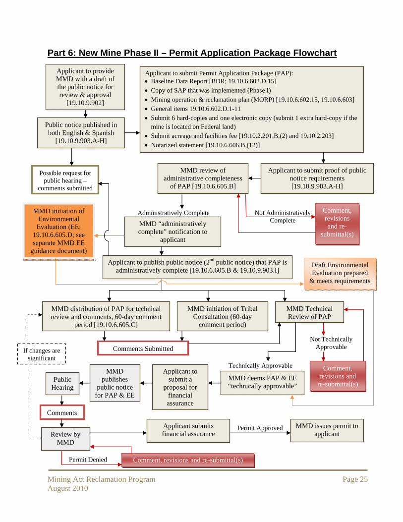
Part 6: New Mine Phase II – Permit Application Package Flowchart
MMD initiation of Tribal Consultation (60-day
comment period)
Not Technically Approvable
Comment, revisions and re-
submittal(s)
Applicant to submit Permit Application Package (PAP): Baseline Data Report [BDR; 19.10.6.602.D.15]
Copy of SAP that was implemented (Phase I)
Mining operation & reclamation plan (MORP) [19.10.6.602.15, 19.10.6.603]
General items 19.10.6.602.D.1-11
Submit 6 hard-copies and one electronic copy (submit 1 extra hard-copy if the mine is located on Federal land)
Submit acreage and facilities fee [19.10.2.201.B.(2) and 19.10.2.203]
Notarized statement [19.10.6.606.B.(12)]
Applicant to submit proof of public notice requirements [19.10.9.903.A-H]
Administratively Complete Not Administratively Complete MMD “administratively
complete” notification to applicant
Applicant to publish public notice (2nd public notice) that PAP is administratively complete [19.10.6.605.B & 19.10.9.903.I]
MMD distribution of PAP for technical review and comments, 60-day comment
period [19.10.6.605.C]
MMD review of administrative completeness
of PAP [19.10.6.605.B]
MMD initiation of Environmental Evaluation (EE;
19.10.6.605.D; see separate MMD EE
guidance document)
MMD Technical Review of PAP
Comments Submitted
Comment, revisions and
re-submittal(s)
Technically Approvable
MMD deems PAP & EE “technically approvable”
Public Hearing
Permit Approved
Permit Denied Comment, revisions and re-submittal(s)
Applicant submits financial assurance
Applicant to submit a
proposal for financial assurance
Comments
Review by MMD
Applicant to provide MMD with a draft of the public notice for review & approval
[19.10.9.902]
Public notice published in both English & Spanish
[19.10.9.903.A-H]
Possible request for public hearing –
comments submitted
Draft Environmental Evaluation prepared
& meets requirements
MMD issues permit to applicant
MMD publishes
public notice for PAP & EE
If changes are significant