Embed Size (px)
Citation preview
!.
!.
!.
!.
!.
!.
!.
!. !.
!.!.
!.
!.
!.
!.
!.
Mulgrave
River
Yorkeys Point
Ellie Point
Cape Grafton
SmithfieldHeights
Deception Point
Trinity Beach
Taylor Point
Simpson Point
Yarrabah
CAPTAIN COOKHIGHWAY
CAIRNS
BARRON
GORGE
NATIONAL
PARK
Barron
River
GREY PEAKSNATIONAL PARK
Buchan Point
Clifton Beach
Yorkeys Knob
Machans Beach
Redlynch
KURANDANATIONAL
PARK
BRUCE
HIGHWAY
False Cape
Edmonton
Gordonvale
DINDEN
NATIONAL
PARK
GREY PEAKSNATIONAL PARK
Tongue Reef
ChannelReef
Pretty Patches
Baines Patches
TrinityInlet
Trinity
Bay
Cook Bay
Michaelmas Cay (NP)
Green Island (NP)
Briggs Reef
StaggPatches
Turtle BayMission Bay
Elford Reef
Stevens ReefFlo
ra
Passa
ge
Satellite Reef
Double Island
Hastings Reef
Pixie Reef
Sudbury Reef
Fitzroy Island (NP)
Little FitzroyIsland
Gunjurra Island
RockyIsland
Trinity
Opening
HaycockIsland
Arlington Reef
Nicholas Reef
Hope Reef
Fin Reef
Milln Reef
Pellowe Reef
UpoluCay(NP)
JorgensenPatch
Grafton
Passa
ge
Moore Reef
WideBay
NorthWestReef
Euston Reef
Thetford Reef
Jenny LouiseShoal
Oyster Reef
Batt Reef
Vlasoff Cay
Sudbury Cay
Scott Reef
Norman Reef
Saxon Reef
Onyx Reef
Spur Reef
Flynn Reef
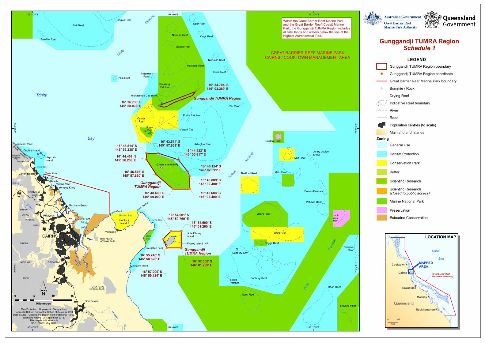
GREAT BARRIER REEF MARINE PARKCAIRNS / COOKTOWN MANAGEMENT AREA
Maori Reef
BreakingPatches
Gunggandji TUMRA Region
GunggandjiTUMRA Region
GunggandjiTUMRA Region
16° 54.601' S145° 59.760' E
16° 55.740' S145° 58.620' E
16° 57.000' S145° 59.124' E
16° 57.000' S146° 01.200' E
16° 43.514' S145° 56.238' E16° 44.409' S
145° 56.238' E
16° 46.566' S145° 57.660' E
16° 48.608' S146° 00.000' E
16° 48.608' S146° 02.400' E
16° 46.809' S146° 02.400' E
16° 46.124' S146° 02.091' E
16° 44.433' S146° 00.817' E
16° 43.514' S145° 57.932' E
16° 34.704' S146° 03.269' E
16° 36.730' S145° 58.038' E
16° 54.600' S146° 01.200' E
146°20'0"E
146°20'0"E
146°0'0"E
146°0'0"E
145°40'0"E
145°40'0"E16
°40'0
"S
16°4
0'0"S
17°0
'0"S
17°0
'0"S
0 5 10 15
Kilometres
´Map Projection: Unprojected Geographics
Horizontal Datum: Geocentric Datum of Australia 1994Data Source: Queensland Department of National Parks,
Sport and Racing, 09 September 2015.This map is indicative only
SDC150803 May 2016
Gunggandji TUMRA RegionSchedule 1
LEGENDGunggandji TUMRA Region boundary
!. Gunggandji TUMRA Region coordinateGreat Barrier Reef Marine Park boundary
L Bommie / RockDrying ReefIndicative Reef boundaryRiverRoadPopulation centres (to scale)Mainland and Islands
Zoning General Use
Habitat Protection
Conservation Park
Buffer
Scientific ResearchScientific Research(closed to public access)Marine National Park
PreservationEstuarine Conservation
Within the Great Barrier Reef Marine Parkand the Great Barrier Reef (Coast) MarinePark, the Gunggandji TUMRA Region includesall tidal lands and waters below the line of theHighest Astronomical Tide.
!
!
!
!
!Cooktown
Cairns
Townsville
Mackay
RockhamptonQueensland
Coral Sea
MAPPEDAREA
LOCATION MAP
Great Barrier Reef Marine Park boundary
0 200Kms