Embed Size (px)
Citation preview

Geospatial Information Authority of Japan
GSI’s Activities for
Geospatial Information Applications
Hiroshi Murakami
Director-General of Geospatial Information Department
Geospatial Information Authority of Japan (GSI)
State Of The Map 2012September 6th – 8th, 2012Tokyo, Japan

Geospatial Information Authority of JapanOverview
1. GSI and its Mission
2. Programs
3. Digital Map Products and Services
4. Potential Cooperation with VGI Initiatives

Geospatial Information Authority of Japan1. GSI and its Mission
• GSI: Geospatial Information Authority of Japan.– Formerly, Geographical Survey Institute.
• Original body was established in 1869.• Responsible for national surveying and ma
pping including law enforcement of the Survey Act.

Geospatial Information Authority of Japan1. GSI and its Mission
• Survey Act:– Standard geodetic datum.– Regulations for surveying and mapping proje
cts conducted by public organizations to ensure the high quality of results and avoid duplicated efforts.
– Licensed surveyor. Public Organizations (80%)
PrivateCompanies(20%)
GSI (1%)
Spending

Geospatial Information Authority of Japan1. GSI and its Mission
GSI’s Mission
• Facilitate applications of geospatial information through the following activities on surveying and mapping so that the users will find them valuable, and hence contribute to the economic growth and the improvement of the quality of life of the people.– Develop, maintain and distribute fundamental geospati
al information;– Develop an environment that facilitates efficient develo
pment of a variety of geospatial information, and allows anybody to easily use it; and
– Cooperate with both domestic and international bodies.
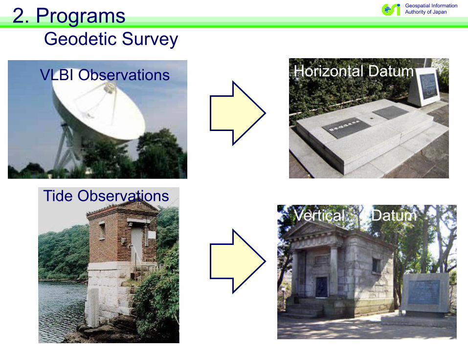
Geospatial Information Authority of Japan2. Programs
Geodetic Survey
VLBI Observations Horizontal Datum
Tide ObservationsVertical Datum

Geospatial Information Authority of Japan2. Programs
Geodetic Survey
Philippine Plate
PacificOceanPlate
N. AmericanPlate
EurasianPlate
2 cm/yr
GNSS-basedControl Station

Geospatial Information Authority of Japan2. Programs
National Mapping
Maintaining topographic maps at multiple scales:1:5M, 1: 1M. 1: 200K, and 1:25K (Whole country)>=1:2.5K ((Urban areas)
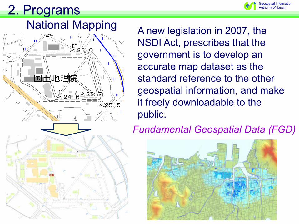
Geospatial Information Authority of Japan2. Programs
National Mapping A new legislation in 2007, the NSDI Act, prescribes that the government is to develop an accurate map dataset as the standard reference to the other geospatial information, and make it freely downloadable to the public.
Fundamental Geospatial Data (FGD)

Geospatial Information Authority of Japan3. Digital Map Products and Services
Primary Products(i) Fundamental Geospatial Data (FGD)
Control points,Transportation, Boundaries, Buildings, Waters
RMSE:=< 2.5m (in urban areas)=< 25 m (outside)
Elevation
RMSE:=< 1 m (in urban areas)=< 5 m (outside)

Geospatial Information Authority of Japan3. Digital Map Products and Services
Primary Products
(ii) Digital Map (National Fundamental Data)
Contents: FGD + Additional geospatial featuresDistribution: Online download or DVD (Vector data)
(iii) Digital Topographic Map 25000Contents: FGD + Additional geospatial featuresDistribution: Online download (PDF)

Geospatial Information Authority of Japan3. Digital Map Products and Services
Web Map Service of GSI

Geospatial Information Authority of Japan3. Digital Map Products and Services
Geospatial data overlaid on Web Map

Geospatial Information Authority of Japan3. Digital Map Products and Services
Web map site developed by local governments

Geospatial Information Authority of Japan3. Digital Map Products and Services
Applications that readGSI web map via the Internet

Geospatial Information Authority of Japan3. Digital Map Products and Services
New version of Web map service that has better compatibility with the others and new map design

Geospatial Information Authority of Japan4. Potential Cooperation with VGI Initiatives
Past Experiences with Volunteers
• Updates/errors/improvements on maps– Infrequent comments/inputs from map users– “Map Monitors”/“Geo-info Monitors” – Cooperation with climbers group for the latest
on mountain trails using GPS loggers
Doesn’t exist
New trail

Geospatial Information Authority of Japan4. Potential Cooperation with VGI Initiatives
Past Experiences with Volunteers
• Response to the Great East Japan Earthquake– Volunteer mapping groups– Sinsai.info
– Emergency Map Team
– Passable/closed road information through crowd-sourcing
Posted on the web

Geospatial Information Authority of JapanPassable/closed roads
Car Movement tracked by Auto Makers Passable Roads
Closed Road Information provided by Government

Geospatial Information Authority of Japan4. Potential Cooperation with VGI Initiatives
Cooperation with OSM Foundation Japan
•GSI created an award program on GIS applications and contents that incorporate GSI data.
•24 nonprofit organizations contributed to the program as the nominating bodies by nominating applications and contents for the award.
•OSMF Japan volunteered as one of the nominating bodies.
Geospatial Information Authority of Japan4. Potential Cooperation with VGI Initiatives
Cooperation with OSM Foundation Japan
• Dr. Furuhashi, Vice President of OSMF Japan, and his colleagues visited GSI in July and initiated a dialogue to discuss potential areas of cooperation, including:– Use of GSI’s web map data by OSMF Japan f
or change detection; and– Secondary uses of FGD by OSMF Japan.
• The dialogue should continue for mutual benefits and understanding.

Geospatial Information Authority of Japan4. Potential Cooperation with VGI Initiatives
Challenges for Further Cooperation (Personal view)
• Quality of provided information– Accuracy: positional, temporal, thematic, and
topological (Verification needed?)• Homogeneity/sustainability
– Inhomogeneous distribution of volunteers?– Any disruption/discontinuation of activities?
• Disaster response– Voluntary vs. Preparedness– Pre-disaster exercises?– How can volunteers and governments work to
gether?

Geospatial Information Authority of Japan4. Potential Cooperation with VGI Initiatives
Summary
• GSI acknowledges important roles VGI will play for the future in geospatial information applications, as they have been internationally appreciated, and exemplified by the disaster response to the Haiti earthquake and others.
• The dialogue has just started, but many positive outcomes and mutual benefits are envisaged for the future, as we work on some outstanding issues.

Geospatial Information Authority of Japan
THANK YOU!
Hiroshi Murakami