Embed Size (px)
Citation preview
GSGS MISC SERIES © M.A. Nolan April 2007
1
GSGS MISCELLANEOUS MAPS – AN INTRODUCTION. The two “poor relations” in any studies of the suite of products produced by the Geographical Section of the General Staff are GSGS Office Reference maps and GSGS Miscellaneous maps. Office Reference Maps (OR Maps). The most familiar manifestation of the OR map is of course the modern map catalogue index map but this is a specialist use of the OR designation. OR maps existed in their own right prior to the adoption of the OR designation for indexes. The OR designation was generally applied to small-format simple outline sketch maps, often monochrome used for a multitude of purposes. They are not without interest however. One use that comes to mind was that of the 3 or four annotated Office Reference maps used to illustrate the stages of the retreat from the Thai border down through the Malay peninsula and onto the island of Singapore in 1942 that were produced presumably for high level briefing purposes. Miscellaneous Maps (Misc Maps). The Misc map is a relatively modern phenomenon, seemingly having been born of the second world war, but its gestation may have been much earlier. The use of non-topographic sketch maps for miscellaneous purposes can be traced back to the early days of numbered War Office maps. The more one looks at the products listed in Crispin Jewitt’s “Maps for Empire – The First 2000 Numbered War Office Maps”, the more one is struck by how few really topographic map series it contains. Of those that are topographic maps, many are medium to small scale compilations, few are original surveyed topographic series and of those, few are of any great geographical extent. So it can be suggested that had many of the maps listed in Jewitt been produced in recent times they might have been given OR or Misc designators. The earliest sheets in the numerical sequence of GSGS Misc maps date from 1943. Unlike the OR map, Misc maps of that period were often large or very large format products and were often multicoloured. These maps are of interest because they were often produced in support of imminent operations or for the planning of future operations. Many were produced under the auspices of the Inter-Service Topographical Department and bear an appropriate production notes, typically : - “Compiled and drawn by Inter-Service Topographical Department.” “Produced under the Superintendence of Vice-Admiral Sir John Edgell, K.B.E., C.B., Hydrographer.” Many were produced for inclusion in intelligence reports or planning dossiers so it is common to find both plain stock maps and a later overprinted variant bearing intelligence document references. The family of GSGS Misc-designated maps reflects many of the operations of WW2. The earliest numbered maps appeared in support of the allied landings in Sicily and Italy in 1943. A particularly interesting batch is that covering the coastline of France also produced from 1943. It is clear from these that, prior to the detailed Operation Overlord planning, the whole coastline of France was subjected to terrain analysis with regard to beach landings and beach exits. Incidentally, these escaped mention in the joint Defence Surveyors’ Association and British Cartographic Society’s seminar on D-Day mapping in 2004. Naturally, in addition to France, Germany features prominently in early Misc-designated maps. Perhaps surprisingly there are many products covering Norway and this perhaps represents forward planning for the liberation of Norway once the invasion of Europe was in full swing. Maps in support of the planning for the re-conquest of Malaya, Singapore, Borneo and Hong Kong also feature quite heavily. About 260 numbers were allocated during and immediately after but relating to the world war. Thereafter, the Misc designation was used for a variety of purposes. Occasionally the Misc designation was used for operational topographic maps, maps of Aden during the 1960’s come to mind. However one of the main uses was for peace-time exercise maps and Staff College and promotion examination papers, the first such map for this purpose being numbered 289. The list forming the main body of this document represents a first attempt to record as far as possible all the World War 2 GSGS Misc designated maps. Additionally, some other GSGS Misc maps of the post-war period that have been seen in passing have been included.

GSGS MISC SERIES © M.A. Nolan April 2007
2
The following list is a simple analysis, or breakdown of World War 2 GSGS Misc-designated maps, into the countries covered by the mapping of those sheets so far found. GEOGRAPHICAL AREA. GSGS MISC NUMBERS. ALBANIA See Yugoslavia. ANTARCTIC 104. ALGERIA 33 AUSTRIA 100, 107, 132, 138, 148, 153, 156, 157, 188, 189, 212, 221, 239. AZORES 37, 39, 45. BELGIUM 66, 78, 87, 159, 247. BORNEO 203-205, 210, 216-217. BULGARIA 130. BURMA 173 CHINA 229-230, 232, 238, 250-251. DENMARK 81, 136 EUROPE 244. EUROPE N.W. 231. FINLAND 63 FORMOSA 125-126, 134, 151, 237. FRANCE 6-16, 18-21, 25-29, 31-32, 34-36, 38, 40, 42-44, 50, 52-55, 60,
61, 65, 67-68, 72, 74-77, 106, 260. GERMANY 80, 108, 114, 117, 120, 149, 155, 161-163, 168, 170-172, 177,
193, 201, 211, 213-215, 218, 222-225, 227, 262. GREECE 154. HOLLAND 79, 88, 167. HONG KONG 192, 194-196, 207-209, 220. HUNGARY 96, 121. INDO-CHINA 147, 257. INDONESIA 110, 144, 152, 185-186, 202, 204, 242, 249, 253, 255. ITALY 1-5, 46, 69-71, 82, 97, 133, 139.

GSGS MISC SERIES © M.A. Nolan April 2007
3
MALAYA & SINGAPORE 89, 91-95, 103-105, 111, 113, 118, 123-124, 128-129, 135, 150, 184, 198, 228, 241, 245, 248.
NORWAY 41?, 49, 51, 56, 58-59, 64, 73, 98-99, 102, 109, 112, 115, 116,
122, 137, 141-143, 158, 160, 164-165, 169, 175-176, 178-183, 187, 190-191, 199-200, 206, 219, 226, 233-234, 236, 246.
SARDINIA 48, 62, 242. SINGAPORE See Malaya. SICILY 17, 22-24, 30, 140. THAILAND 166, 252, 256. TUNISIA 240. UNIDENTIFIED 235, 258, 259. YUGOSLAVIA/ALBANIA 47, 57, 83-86, 90, 101, 119, 127, 131, 145-146, 174, 254, 261. It should be noted that many of the above designations are of single sheet series. However, many are multiple sheet series. For instance there are about 24 “town plans” or similar maps of Borneo with the number GSGS Misc 203. The Miscellaneous designator was of course used in other theatres in World War 2 and after. The following list, not guaranteed to be error free, has been condensed from “Webster”. (Cataloguers’ Notes No. 36, Military Publishers’ Designations) : - Designation Authority using. Period in use. AFN Misc Allied Forces Netherlands East Indies Sep 45 – Nov 46 AHQ Misc Australian Forces HQ 1949 – 1970 BAOR Misc British Army of the Rhine Jul 45 - ???? BTA Misc British Troops Austria Jul 45 – Jul 46 EAF Misc East Africa Force Aug 40 – Nov 47 EDR Misc British Troops Egypt Oct 42 – Jan 44 FARELF Misc Far East Land Forces Aug 47 – Dec 70 FIR Misc First Australian Army Jun 43 - ??? 49 GSGS Misc Geographical Section General Staff Mar 43 – Jun 75 HIND/A & HIND/A/Misc HQ India Air Apr 44 – Jan 46 DD Svy Air Jan 46 - ??? 1947 HIND/CLN & HIND/CLN/Misc HQ India/Ceylon Jul 42 – Apr 44 Svyr Gen Ceylon Jan 46 - ??? 47 HIND/E & HIND/E/Misc HQ India Eastern Jul 42 – Apr 44

GSGS MISC SERIES © M.A. Nolan April 2007
4
DD Svy Eastern Army/XIV Army Apr 44 – Jan 46 Eastern Army/XIV Army Jan 46 - ??? 47 HIND/F & HIND/F/Misc HQ India Frontier ??? – Aug 43 - ??? XII Army/ Svy HQ Burma Command ??? – Oct 46 – Jul 47 HIND/NW & HIND/NW/Misc HQ India N.W. Jul 42 – Apr 44 DFC NW Circle NW Army Apr 44 – Jan 46 NW Army/Northern Command India Jan 46 - ??? 47 HIND/S & HIND/S/Misc HQ India Southern Aug 43 – Apr 44 South Army Apr 44 – Jan 46 Southern Army/Southern Command Jan 46 - ??? 47 HIND/SEA & HIND/SEA/Misc HQ India/South East Asia/11 Army Gp Apr 44 – Jan 46 ALFSEA/ 11 Army Gp Jan 46 - ??? 47 HKLF Misc Hong Kong Land Forces Mar 74 - ??? 97 HO Misc Hydrographic Office U.S. Navy Jul 43 ???????? IC Misc 1st Corps BAOR Jul 45 – May 46? ID Misc Iraq Directorate Dec 41 – Feb 42 IDR Misc Iraq Drawing & Reproduction Aug 42 – Nov 42 LHQ Misc Land Forces HQ Jun 43 - ??? 49 MDR Misc Middle East Drawing & Repoduction Mar 40 – Aug 46 NE Misc Near East Land Forces Mar 65 – Apr 78 NGF Misc New Guinea Forces Jun 43 - ??? 49 NLC Misc New South Wales LoC Jun 43 - ??? 49 NORTHAG Misc Northern Army Group ?????? - ?????? PDR Misc Palestine Drawing & Reproduction Aug 41 – Sep 41 PID Misc Persia & Iraq Directorate Feb 42 – Nov 42 QLC Misc Queensland LoC Jun 43 - ??? 49 SA Misc Second Army May 43 – Jun 45 SEA Misc South East Asia Apr 44 - ??? 47 SEC Misc Second Australian Army Jun 43 - ??? 49 SVY Misc Survey Service New Guinea Force Jul 42 – Jun 43 UDF Misc Union Defence Force Mar 42 – Apr 45

GSGS MISC SERIES © M.A. Nolan April 2007
5
UKLF Misc United Kingdom Land Forces Jul 74 – Mar 79 VLC Misc Victoria LoC Jun 43 - ??? 49 2CO Misc 2nd Australian Corps Jun 43 - ??? 49 3CO Misc 3rd Australian Corps Jun 43 - ??? 49 8A Misc Eighth Army Sep 43 – Jul 45 15AG Misc 15th Army Group Dec 44 – Jul 45

GSGS MISC SERIES © M.A. Nolan April 2007
6
NUMERICAL LIST OF MAPS WITH GSGS MISC DESIGNATIONS 1 – ROADS SICILY AND CALABRIA. 1:1,000,000. ISTD. PRO WO 401/23 Numerical Catalogue of Maps January 1944. Seen 5-5-04 Map NYS 2 – SICILY LINE COMMUNICATIONS. No scale statement. Annotated in pencil, “Ca 1:600,000.” Monochrome map of Sicily with arbitrary 6.5 cm map squares A-G W-E & 1-5 N-S, 57 x 36.5 cms oa. Legend. G.S.G.S. (Misc.) No. 2. War Office 1943. DGC GSGS Misc. Seen 12-7-04 BOD C25:26(6) Seen 25-7-05 3 – SICILY TOWN PLANS. 1:250,000. ISTD. PRO WO 401/23 Numerical Catalogue of Maps January 1944. Seen 5-5-04 Map NYS 4 – THE CALABRIAN PENINSULA GENERAL TOPOGRAPHY. Scale 1:250,000 Layered, black, brown, blue map of the area south of a line from Amantea to Crotone, 70 x 59 on 76 x 65 cms oa. Layer tints. Flat or Undulating Land. Marsh and Water obstacles. Escarpments. Roads. Railways. Beaches with good exits to interior or principal towns. Beaches with access to coastal road and railway only. Compiled and drawn by Inter-Service Topographical Department. G.S.G.S. (Misc.) No. 4. War Office 1943. DGC GSGS Misc. Date-stamped GSGS 2 Apr 1943. Seen 12-7-04 BOD C25:12(2) Seen 25-7-05 5 – THE CALABRIAN PENINSULA – TOPOGRAPHICAL REGIONS. Scale 1:250,000 Black, brown, blue, green map of the area from Aspromonte in the S.W. to Sila Piccola in the north, 81 x 59.5 on 88.5 x 74 cms oa. Key to Topographical Regions I to XI. Contours in metres. Alluvium. Sand. Woods, Beech, Fir, Spruce, Oak; Chestnut. Boundaries of Topographical regions. Photograph Numbers. Compiled and drawn by Inter-Service Topographical Department. G.S.G.S. (Misc.) No. 5. War Office 1943. BOD C25:12(1) Seen 25-7-05 6 – NAVIGABLE SEINE. 1:80,000 ISTD. PRO WO 401/23 Numerical Catalogue of Maps January 1944. Seen 5-5-04 Map NYS 7 – FRANCO-BELGIAN FRONTIER TO SANGATTE. Scale 1:50,000. From G.S.G.S. Series 4040 Sheets 29, 38, 39 (Second Edition), amended by I.S.T.D. from Air Photographs, Oct. 1941 – May 1942. NNW oriented, black, blue, red map of the area from 1-45 to 2-35E & 50-45 to 51-02N with 5 minute ticks and values round the neat line, 121.5 x 29 on 127 x 35.5 cms oa. Reference. Beach described in text. Sand dunes. Main road. Secondary roads. Other roads. Railway. Coast Guard Station. Built-up area. Compiled and drawn by Inter-Service Topographical Department. Produced under the Superintendence of Vice-Admiral Sir John Edgell, K.B.E., C.B., Hydrographer.

GSGS MISC SERIES © M.A. Nolan April 2007
7
Geographical Section, General Staff, Misc., 7. War Office 1943. PRO WO 401/23 Numerical Catalogue of Maps January 1944. Seen 5-5-04 BL 14351.(33.) Date-stamped BM 5 Dec 45. Seen 19-5-04 BOD C21:1(104) Seen 14-6-04 DGC GSGS Misc. Date-stamped GSGS 27 Apr 1943. Seen 12-7-04 8 – SANGATTE - BOULOGNE – ETAPLES. Scale 1:50,000. Black, blue, red map of the area from Etaples in the south to Calais in the NE, with no graticule or grid, 65.5 x 119.5 on 71 x 125 cms oa. Reference. Topographic Regional Boundaries. Flat alluvial valleys. Dune areas. Chalk scarp. Beaches. Landing places. Railway. Light railway. Road (1st class). Road (2nd class). Spot-heights in metres. Compiled and drawn by Inter-Service Topographical Department. Produced under the Superintendence of Vice-Admiral Sir John Edgell, K.B.E., C.B., Hydrographer. Geographical Section, General Staff, Misc., 8. War Office 1943. PRO WO 401/23 Numerical Catalogue of Maps January 1944. Seen 5-5-04 BL 14351.(33.) Date-stamped BM 5 Dec 45. Seen 19-5-04 BOD C21:1(104) Seen 14-6-04 DGC GSGS Misc. Date-stamped DMS 1 Jul 1968. Seen 12-7-04 9 – AVRANCHES - St. MALO. Scale 1:50,000 or 1 Inch to 0.79 Miles. Black, blue, red map of the area from 1-20 to 2-01W & 48-30 to 48-44N with 5 minute ticks and values round the neat line, 86.5 x 94 on 88.5 x 101 cms oa. Reference. Beaches. Landing places. Main road. Secondary roads. Other roads. Tracks. Railways. Light railways. Observation points. Heights are shown in feet. Areas with loamsoil. Compiled and drawn by Inter-Service Topographical Department. Produced under the Superintendence of Vice-Admiral Sir John Edgell, K.B.E., C.B., Hydrographer. Geographical Section, General Staff, Misc., 9. War Office 1943. PRO WO 401/23 Numerical Catalogue of Maps January 1944. Seen 5-5-04 BL 14351.(33.) Date-stamped BM 8 Dec 45. Seen 19-5-04 BOD C21:1(104) Seen 14-6-04 DGC GSGS Misc. Date-stamped DMS 1 Jul 1968. Seen 12-7-04 10 – St. MALO - St. BRIEUX. Scale 1:54,890. Black, blue, red map of the area from 2-00 to 2-47W & 48-29 to 48-46N with 5 minute ticks and values round the neat line, 108 x 60 on 111.5 x 65 cms oa. General Topographical Notes. Reference. 1st Class roads. 2nd Class roads. Other roads. Tracks and footpaths. Main Railways. Light railways. Beeches. Landing places. Spot heights in feet. Areas of flat alluvial land etc. Sand dunes. Loam covered high land etc. Pottery clay area etc. Observation points inland etc. Steep or cliff slopes etc. Woods in coastal areas etc. Compiled and drawn by Inter-Service Topographical Department. Produced under the Superintendence of Vice-Admiral Sir John Edgell, K.B.E., C.B., Hydrographer. Geographical Section, General Staff, Misc., 10. War Office 1943. PRO WO 401/23 Numerical Catalogue of Maps January 1944. Seen 5-5-04 BL 14351.(33.) Date-stamped BM 5 Dec 45. Seen 19-5-04 BOD C21:1(104) Seen 14-6-04 DGC GSGS Misc. Date-stamped GSGS 27 Apr 1943. Seen 12-7-04 11 – GUISSENY – PTE. DE St MATHIEU. Scale 1:50,000. N.W. oriented, black, blue, red map of the area from Plougonvelin in the S.W. via le Conquet, Lanildut, St. Pabu, Landeda and Plouguerneau in the N.E., 94 x 59 on 101 x 69 cms oa. Reference. Roads and Cross Country Movement. Topography. Compiled and drawn by Inter-Service Topographical Department. Produced under the Superintendence of Vice-Admiral Sir John Edgell, K.B.E., C.B., Hydrographer. Geographical Section, General Staff, Misc., 11. War Office 1943.

GSGS MISC SERIES © M.A. Nolan April 2007
8
DGC GSGS Misc. Date-stamped DMS 1 Jul 1968. Seen 12-7-04 12 – MENLIMONT PLAGE – BAIE DE SOMME. Scale 1:50,000. Black, blue, red map of the area from Baie de Somme in S. via Baie D’Authie and Berck-Plage to Merlimont Plage in the N., 24.5 x 50 on 32 x 55 cms oa., showing Beaches B15 and B14. Untitled reference. Based on GSGS Maps Series 4040 2nd Edition (1941). Compiled and drawn by Inter-Service Topographical Department. Produced under the Superintendence of Vice-Admiral Sir John Edgell, K.B.E., C.B., Hydrographer. War Office 1943 Geographical Section, General Staff - Misc., 12. DGC GSGS Misc. Date-stamped GSGS 20 Apr 1943. Seen 12-7-04 13 – PORT DE SAINTE – VALERY-SUR-SOMME. Approximate Scale. On scale, 1000 ft = 6 ins. (1:2,000). N.E. oriented, black and blue map of Saint Valery Sur Somme showing ther lock and berths, 73.5 x 31 on 76 x 36.5 cms oa. Compiled and drawn by Inter-Service Topographical Department. Produced under the Superintendence of Vice-Admiral Sir John Edgell, K.B.E., C.B., Hydrographer. Geographical Section, General Staff - Misc., 13. War Office 1943. DGC GSGS Misc. Date-stamped GSGS 27 May 1943. Seen 12-7-04 14 – THE ROUEN AREA. Scale 1:80,000. Black, blue, red map centred on Rouen showing roads and railways and woods, 43 x 47 on 48 x 53 cms oa. Reference – Main Road. Secondary Road. Railway. Vulnerable Points. War Office 1943. Compiled and drawn by Inter-Service Topographical Department. Produced under the Superintendence of Vice-Admiral Sir John Edgell, K.B.E., C.B., Hydrographer. War Office 1943 Geographical Section, General Staff - Misc., 14. DGC GSGS Misc. Date-stamped GSGS 20 Apr 1943. Seen 12-7-04 15 – PLAN OF OUISTREHAM – CAEN CANAL. Scale. R.F. 1:20,000 N.W. oriented map of the area from Ouistreham to Caen along the canal route, 91.5 x 26 on 93 x 30 cms oa. Compiled and drawn by Inter-Service Topographical Department. Produced under the Superintendence of Vice-Admiral Sir John Edgell, K.B.E., C.B., Hydrographer. Geographical Section, General Staff - Misc., 15. War Office 1943. DGC GSGS Misc. Date-stamped DMS 1 Jul 1968. Seen 12-7-04 BOD C21:37(7) Seen 1-7-05 16 – St. VALERY EN CAUX – GRID PROVISIONAL – FIRST EDITION. Scale 1:4400. Black and blue map of the area centred on 0-43E & 49-52N, 42 x 53 on 48 x 57 cms oa. Compiled and drawn by Inter-Service Topographical Department. Produced under the Superintendence of Vice-Admiral Sir John Edgell, K.B.E., C.B., Hydrographer. Geographical Section, General Staff - Misc., 16. War Office 1943. DGC GSGS Misc. Date-stamped GSGS 6 Mar 1944. Seen 12-7-04 16 – CB 4096J - St. VALERY EN CAUX – GRID PROVISIONAL – FIRST EDITION – CONFIDENTIAL – March 1943. Scale 1:4400. Black and blue map of the area centred on 0-43E & 49-52N, 42 x 53 on 48 x 57 cms oa. Compiled and drawn by Inter-Service Topographical Department. Produced under the Superintendence of Vice-Admiral Sir John Edgell, K.B.E., C.B., Hydrographer. Geographical Section, General Staff - Misc., 16. War Office 1943. On reverse, C.B. 4096J March 1943 St. Valery En Caux Port and Town Plan 128. PRO ADM 234/757 Seen 20-7-06

GSGS MISC SERIES © M.A. Nolan April 2007
9
16 – PAIMBOEUF. Scale 1:9170. Black and blue plan of Paimboeuf on the River Loire, centred on 2-50W & 47-17-10N, 29 x 16.5 on 32 x 20.5 cms oa. Compiled and drawn by Inter-Service Topographical Department. Produced under the Superintendence of Vice-Admiral Sir John Edgell, K.B.E., C.B., Hydrographer. G.S.G.S. (Misc.) 16. War Office 1943. DGC GSGS Misc. Date-stamped DMS 1 Jul 1968. Seen 12-7-04 16 – LE POLIGUEN. Scale 1:2720. Black and blue plan of Pouliguen on route N.771 to St. Nazaire, 25 x 38 on 30 x 44 cms oa. Compiled and drawn by Inter-Service Topographical Department. Produced under the Superintendence of Vice-Admiral Sir John Edgell, K.B.E., C.B., F.R.S., Hydrographer. G.S.G.S. (Misc.) 16. War Office 1943. DGC GSGS Misc. Date-stamped DMS 1 Jul 1968. Seen 12-7-04 16 – LA TURBALLE. Yards. On scale, 600 = 2.75 ins. (1:7850) Black and blue plan of La Turballe 15 x 13 on 19.5 x 29.5 cms oa. Compiled and drawn by Inter-Service Topographical Department. Produced under the Superintendence of Vice-Admiral Sir John Edgell, K.B.E., C.B., F.R.S., Hydrographer. G.S.G.S. (Misc.) 16. War Office 1943. DGC GSGS Misc. Date-stamped GSGS 13 Oct 1943. Seen 12-7-04 17 – SICILY – RAILWAYS. Scale 1:500,000 (approx). Black and blue outline map of Sicily showing railways, 62 x 43 on 63 x 51 cms oa. Key to Line Numbers. Standard gauge. Narrow Gauge. Partly Constructed. Rack Scheme. Compiled and drawn by Inter-Service Topographical Department. Produced under the Superintendence of Vice-Admiral Sir John Edgell, K.B.E., C.B., Hydrographer. Geographical Section, General Staff Misc., 17. War Office. DGC GSGS Misc. Date-stamped DMS 1 Jul 1968. Seen 12-7-04 BOD C25:26(4) Seen 25-7-05 18 – MORLAIX TO GUISSENY. Scale 1:50,000. Black, blue, red map of the area from 3-45 to 4-27W & 48-28 to 48-45N with 5 minute ticks and values round the neat line, 103.5 x 61 on 112 x 65.5 cms oa. Reference. Beaches. Landing places. Main roard Secondary roads. Other roads. Tracks – to beaches only. Railways. Light railways. Prepared exits for M/T or AFVs. Heights are shown in feet. Compiled and drawn by Inter-Service Topographical Department. Produced under the Superintendence of Vice-Admiral Sir John Edgell, K.B.E., C.B., Hydrographer. Geographical Section, General Staff, Misc., 18. War Office 1943. PRO WO 401/23 Numerical Catalogue of Maps January 1944. Seen 5-5-04 BL 14351.(33.) Date-stamped BM 5 Dec 45. Seen 19-5-04 BOD C21:1(104) Seen 14-6-04 DGC GSGS Misc. Date-stamped GSGS 27 Apr 1943. Seen 12-7-04 19 - THE NORTH-EAST COAST OF FRANCE FROM THE FRANCO-BELGIAN FRONTIER TO LE HAVRE – BEACHES & LANDINGS. Scale 1 inch to 3.945 Miles or 1.014 Inches to 4 Miles. Black, brown, blue, red map of the area from 2-05W to 0-20E & 48-30 to 50-00N with 30 minute ticks and values round the neat line, 73 x 65 on 78 x 71 cms oa. Detailed Reference. Tables of Landings and Beaches. Compiled and drawn by Inter-Service Topographical Department. Produced under the Superintendence of Vice-Admiral Sir John Edgell, K.B.E., C.B., Hydrographer. Geographical Section, General Staff, Misc., 19. War Office 1943.

GSGS MISC SERIES © M.A. Nolan April 2007
10
London, War Office, 1943. BL 14317.(210) Date-stamped BM 8 Dec 45. Seen 19-5-04 DGC GSGS Misc. Date-stamped DMS 1 Jul 1968. Seen 12-7-04 BOD C21:2(132) Seen 1-7-05 20 - NORMANDY WEST OF THE SEINE – THE SEINE ESTUARY TO AVRANCHES – BEACHES & LANDINGS. Scale 1 inch to 3.945 Miles or 1.014 Inches to 4 Miles. Black, brown, blue, red map of the area from 0-05 to 2-050E & 49-30 to 51-20N with 30 minute ticks and values round the neat line, 83 x 86 on 91 x 92 cms oa. Detailed Reference. Tables of Landings and Beaches. Important Note. Compiled and drawn by Inter-Service Topographical Department. Produced under the Superintendence of Vice-Admiral Sir John Edgell, K.B.E., C.B., Hydrographer. Geographical Section, General Staff, Misc., 20. War Office 1943. BL 14317.(211.) Date-stamped BM 8 Dec 45. Seen 19-5-04 DGC GSGS Misc. Date-stamped DMS 1 Jul 1968. Seen 12-7-04 BOD C21:37(12) Seen 1-7-05 21 – DONGES – PLAN OF PORT. Scale 1:3,460. Black and blue plan of Donges, on the Seine mouth, 2-4-22W47-18-28N, 61.5 x 49.5 on 66 x 55 cms oa. Compiled and drawn by Inter-Service Topographical Department. Produced under the Superintendence of Vice-Admiral Sir John Edgell, K.B.E., C.B., Hydrographer. Geographical Section, General Staff, Misc., 21. War Office 1943. DGC GSGS Misc. Date-stamped DMS 1 Jul 1968. Seen 12-7-04 22 – ALCAMO – SEGESTA – TRAPANI LINE – Line 1A – 1938. Trace of Line Scale 1:50,000. Black and red map 89 x 28 cms max with inset Gradient Profile, 59 x 9 cms max on sheet 94 x 35 cms oa. Reproduced by Inter-Service Topographical Department. Produced under the Superintendence of Vice-Admiral Sir John Edgell, K.B.E., C.B., Hydrographer. Geographical Section, General Staff, Misc., 22. War Office 1943. DGC GSGS Misc. Date-stamped DMS 1 Jul 1968. Seen 12-7-04 BOD C25:26(19) Seen 25-7-05 23 - SICILY – WEST AND NORTH COASTS – BERTHING PLANS Scale for all plans 1:10,000. Black and blue plans of Trapani, 28 x 13 cms; Marsala, 17 x 18 cms; Milazzo, 8 x 13 cms; Palermo, 15 x 25 cms; Termini Imerese, 15 x 23 cms; on sheet 63 x 36 cms oa. Compiled and drawn by Inter-Service Topographical Department. Produced under the Superintendence of Vice-Admiral Sir John Edgell, K.B.E., C.B., Hydrographer. Geographical Section, General Staff, Misc., 23. War Office 1943. BL 24219.(2.) Date-stamped BM 8 Dec 45. Seen 19-5-04 DGC GSGS Misc. Date-stamped GSGS 12 May 1943. Seen 12-7-04 BOD C25:26(20) Seen 25-7-05 24 - SICILY – SOUTH AND EAST COASTS – ACCOMMODATION & BERTHING. Scale for all plans 1:10,000. Black and blue plans of Porto Empedocle, 9 x 14 cms; Licata, 11 x 13 cms; Catania, 13 x 19 cms; Messina, 17 x 15 cms; Siracusa, 19 x 18 cms; on sheet 37 x 63 cms oa. Compiled and drawn by Inter-Service Topographical Department. Produced under the Superintendence of Vice-Admiral Sir John Edgell, K.B.E., C.B., Hydrographer. Geographical Section, General Staff, Misc., 24. War Office 1943. BL 24219.(3.) Date-stamped BM 8 Dec 45. Seen 19-5-04 DGC GSGS Misc. Date-stamped GSGS 12 May 1943. Seen 12-7-04

GSGS MISC SERIES © M.A. Nolan April 2007
11
25 – FRANCE – RADE DE BREST PTE. DE St. MATHIEU – PTE. DU TOULINGUET. Scale 1:50,000. From G.S.G.S. 4040B Sheets 57 N.E. & S.E.; 58 S.W. & 73 N.W., and G.S.G.S. 4250 2G/3 & 2G/6. Black, blue, red map of the area from 4-03 to 4-45W & 48-11 to 48-28N with 5 minute ticks and values round the neat line, 105 x 67 on 111.5 x 76.5 cms oa. Reference. Beaches. Landing places. Main roads. Secondary roads. Other roads. Tracks – to beaches only. Railways. Light railways. Heights are shown in feet. Observation points. Compiled and drawn by Inter-Service Topographical Department. Produced under the Superintendence of Vice-Admiral Sir John Edgell, K.B.E., C.B., Hydrographer. Geographical Section, General Staff, Misc., 25. War Office 1943. PRO WO 401/23 Numerical Catalogue of Maps January 1944. Seen 5-5-04 BL 14351.(33.) Date-stamped BM 8 Dec 45. Seen 19-5-04 BOD C21:1(104) Seen 14-6-04 DGC GSGS Misc. Date-stamped GSGS 25 May 1943. Seen 12-7-04 26 – SPANISH FRONTIER TO NARBONNE PLAGE. Based on Michelin Map, Sheet 86. Scale 1:200,000. Black, blue, red map, 41.5 x 47 on 50.5 x 56 cms oa. Reference - Beaches. Landings. Road, First Class. Road Second Class. Other Roads. Main railways. Other Railways. Canal. Wooded Area. Marsh. Height in feet. Compiled and drawn by Inter-Service Topographical Department. Produced under the Superintendence of Vice-Admiral Sir John Edgell, K.B.E., C.B., Hydrographer. Geographical Section, General Staff, Misc., 26. War Office 1943. DGC GSGS Misc. Date-stamped GSGS 25 May 1943. Seen 12-7-04 27 – NARBONNE PLAGE TO PORT St. LOUIS. Based on Michelin Map, Sheet 83. Scale 1:200,000. Black, blue, red map, 82 x 45 on 87.5 x 51 cms oa. Reference - Beaches. Landing Places. First Class Road. Second Class Road. Other Roads. Main railways. Other Railways. Canal. Wooded Area. Marsh. Height in feet. Compiled and drawn by Inter-Service Topographical Department. Produced under the Superintendence of Vice-Admiral Sir John Edgell, K.B.E., C.B., Hydrographer. Geographical Section, General Staff, Misc., 27. War Office 1943. DGC GSGS Misc. Date-stamped GSGS 25 May 1943. Seen 12-7-04 28 – PORT St. LOUIS TO FRANCO-ITALIAN FRONTIER. Based on Michelin Map, Sheet 84. Scale 1:200,000 Black, blue, red map, 112 x 57 on 117 x 65 cms oa. Reference - Beaches. Landing Places. First Class Road. Second Class Road. Other Roads. Main railways. Other Railways. Canal. Wooded Area. Marsh. Height in feet. Franco-Italian Frontier. Compiled and drawn by Inter-Service Topographical Department. Produced under the Superintendence of Vice-Admiral Sir John Edgell, K.B.E., C.B., Hydrographer. Geographical Section, General Staff, Misc., 28. War Office 1943. DGC GSGS Misc. Date-stamped GSGS 25 May 1943. Seen 12-7-04 PRO ADM1/11326 NYS 29 – BELLE ISLE-EN-MER. Scale 1:50,000. From G.S.G.S. 4040B Sheet 103 S.W. Black, blue, map of the area from 3-02 to 3-17W & 47-15 to 47-25N with 5 minute ticks and values round the neat line, 35.5 x 30.5 on 40.5 x 33 cms oa. Reference. Beaches. Landing places. Principal road. Other roads. Tracks. Valleys mostly dry. Woods. Heights are shown in feet. Prepared by Inter-Service Topographical Department. Produced under the Superintendence of Vice-Admiral Sir John Edgell, K.B.E., C.B., Hydrographer. G.S.G.S. (Misc.) 29. War Office 1943. PRO WO 401/23 Numerical Catalogue of Maps January 1944. Seen 5-5-04 BL 14351.(33.) Date-stamped BM 8 Dec 45. Seen 19-5-04

GSGS MISC SERIES © M.A. Nolan April 2007
12
DGC GSGS Misc. Date-stamped GSGS 5 Oct 1943. Seen 12-7-04 30 – PORTO S. NICOLO SASENO ISLAND. Scale 1:2,500. Black and blue plan of harbour, 19-17-10E & 40-30N, 33 x 33 on 37.5 x 37.5 cms oa. Relief shown by hachures. Compiled and drawn by Inter-Service Topographical Department. Produced under the Superintendence of Vice-Admiral Sir John Edgell, K.B.E., C.B., F.R.S., Hydrographer. G.S.G.S. Misc. 30. War Office,1943. BL 14351.(33.) Date-stamped BM 8 Dec 45. Seen 19-5-04 DGC GSGS Misc. Date-stamped GSGS 3 Jan 1944. Seen 12-7-04 BOD C6:20Porto S. Nicolo(1) Seen 2-6-05 31– NORTH EAST FRANCE – WATERWAYS. Scale 1 Inch to 3.945 Miles. 1 Centimetre to 2.5 Kilometres. N.E. oriented, black, blue, red diagrammatic waterways map, showing waterways between Le Havre and Paris and north to Dunkerque, 68.5 x 111 on 82.5 x 113 cms oa. Detailed Reference, not noted. Compiled and drawn by Inter-Service Topographical Department. Produced under the Superintendence of Vice-Admiral Sir John Edgell, K.B.E., C.B., Hydrographer. G.S.G.S. (Misc.) 31. War Office 1943. DGC GSGS Misc. Date-stamped DMS 1 Jul 1968. Seen 12-7-04 BOD C21:2(130) Seen 1-7-05 32– FRANCE N.W. – PTE. DE SOUCHE – PTE DE TREVIGNON. Scale 1:50,000. Black, blue, red map of the area from 3-50 to 4-26W & 47-42 to 48-02N with 5 minute ticks and values round the neat line, 93 x 72.5 on 101 x 78 cms oa. Topography. Reference. Beaches. Landing places. Main roads. Secondary roads. Other roads. Tra Compiled and drawn by Inter-Service Topographical Department. Produced under the Superintendence of Vice-Admiral Sir John Edgell, K.B.E., C.B., Hydrographer. Geographical Section, General Staff, Misc., 32. War Office 1943. PRO WO 401/23 Numerical Catalogue of Maps January 1944. Seen 5-5-04 BL 14351.(33.) Date-stamped BM 5 Dec 45. Seen 19-5-04 BOD C21:1(104) Seen 14-6-04 DGC GSGS Misc. Date-stamped GSGS 1 Jun 1943. Seen 12-7-04 Note, the use of 32 is duplicated : - 32– St. BRIEUC – TREGUIER. Scale 1:50,000 or 1 Inch to 0.79 Miles. Black, blue, red map of the area from 2-40 to 3-15W & 48-30 to 48-54N with 5 minute ticks and values round the neat line, 87 x 93 on 89 x 103 cms oa. Topographical Notes. Reference. Topographical District Boundaries. Topographical Districts. Beaches. Landing places. Main road. Secondary roads. Other roads. Tracks – shown only to beaches and landing places. Railways. Light railways. Steep slopes of valleys. Flat bottoms of river courses. Woods Coastal, from aerial photographs, inland from other sourcers. Woods, less dense and strips only. Heights are shown in feet. Areas with loam soil. Characteristics. Compiled and drawn by Inter-Service Topographical Department. Produced under the Superintendence of Vice-Admiral Sir John Edgell, K.B.E., C.B., F.R.S., Hydrographer. Geographical Section, General Staff, Misc., 32. War Office 1943. DGC GSGS Misc. Date-stamped GSGS 20 Aug 1943. Seen 12-7-04 32– FRANCE – PTE. DE TOULINGUET – PTE DE SOUCH. Scale 1:50,000. Black, blue, red map of the area from 4-07 to 4-45W & 48-00 to 48-20N with 5 minute ticks and values round the neat line, 97 x 86 on 101.5 x 91 cms oa. Topography (Notes). Reference. Beaches. Landing places. Main roads. Secondary roads. Other roads. Tracks – to beaches only. Railways. Light railways. Observation points. Heights are shown in feet.

GSGS MISC SERIES © M.A. Nolan April 2007
13
Compiled and drawn by Inter-Service Topographical Department. Produced under the Superintendence of Vice-Admiral Sir John Edgell, K.B.E., C.B., Hydrographer. Geographical Section, General Staff, Misc., 32. War Office 1943. PRO WO 401/23 Numerical Catalogue of Maps January 1944. Seen 5-5-04 BL 14351.(33.) Date-stamped BM 5 Dec 45. Seen 19-5-04 BOD C21:1(104) Seen 14-6-04 DGC GSGS Misc. Date-stamped GSGS 28 May 1943. Seen 12-7-04 33– ALGERIA. Scale 1:2,000,000 – 1 Inch to 31.56 Miles. Layered, black, brown, blue map of the area from 3-00W to 9-00E & 31-20 to 37-30N with 1 degree graticule and values and 10 minute divisions round the neat line, 57 x 34 on 65 x 45 cms oa. Altitude Tints. Compiled and drawn by N.I.D.5. Photolithographed by War Office. 1943. Geographical Section, General Staff, (Misc.) No. 33. Published by War Office, 1943. 1,500/12/43. S.P.C. DGC GSGS Misc. Date-stamped DMS 1 Jul 1968. Seen 12-7-04 BOD E22(103) Seen 19-6-06 PRO ADM 234/85 NYS 34– FRANCE – RIVER VILAINE PTE. DE St. GILDAS (LOIRE AREA) Scale 1:50,000 or 1 Inch to 0.79 Miles. Black, blue, red map of the area from 1-55 to 2-35W & 47-09 to 47-31N with 5 minute ticks and values round the neat line, 105 x 85 on 110 x 89 cms oa. Reference. Topographical district & sub-district boundaries. Beaches. Landing places. Main roads. Secondary roads. Other roads. Railways. Light railways. Salt pans or oyster beds. Sand. Alluvium. Pine Forests. Woods. Observation points. Heights are shown in feet. Compiled and drawn by Inter-Service Topographical Department. Produced under the Superintendence of Vice-Admiral Sir John Edgell, K.B.E., C.B., Hydrographer. Geographical Section, General Staff, Misc., 34. War Office 1943. PRO WO 401/23 Numerical Catalogue of Maps January 1944. Seen 5-5-04 BL 14351.(33.) Date-stamped BM 8 Dec 45. Seen 19-5-04 BOD C21:1(104) Seen 14-6-04 DGC GSGS Misc. Date-stamped GSGS 22 Jun 1943. Seen 12-7-04 35 – RIVER AULAY – R. VILAINE. (From G.S.G.S. 4040B). Scale 1:50,000 or 1 Inch to 0.79 Miles. Black, blue, red map of the area from 2-14 to 2-58W & 47-27 to 47-43N with 5 minute ticks and values round the neat line, 113 x 51.5 on 117 x 58 cms oa. Reference. Topographical district boundaries. Topographical sub-district b oundaries. Beaches. Landing places. Main roard. Secondary roads. Other roads. Railways. Light railways. Salt pans or oyster beds. Sand. Alluvium. Observation points. Heights are shown in feet. Compiled and drawn by Inter-Service Topographical Department. Produced under the Superintendence of Vice-Admiral Sir John Edgell, K.B.E., C.B., Hydrographer. Geographical Section, General Staff, Misc., 35. War Office 1943. PRO WO 401/23 Numerical Catalogue of Maps January 1944. Seen 5-5-04 BL 14351.(33.) Date-stamped BM 5 Dec 45. Seen 19-5-04 BOD C21:1(104) Seen 14-6-04 DGC GSGS Misc. Date-stamped DMS 1 Jul 1968. Seen 12-7-04 36 – PTE DE TREVIGNON – RIVER ETEL. Scale 1:50,000 or 1 Inch to 0.79 Miles. Black, blue, red map of the area from 3-13 to 3-50W & 47-35 to 47-55N with 5 minute ticks and values round the neat line, 97 x 79.5 on 102 x 84 cms oa. Topographical Notes to areas I to XI. Reference. Topographical boundaries. Beaches. Landing places. Main roads. Secondary roads. Other roads. Woods. Quarries. Sand. Built-up areas. Railways. Light railways. Observation point. Heights in feet. Compiled and drawn by Inter-Service Topographical Department. Produced under the Superintendence of Vice-Admiral Sir John Edgell, K.B.E., C.B., Hydrographer. Geographical Section, General Staff, Misc., 36. War Office 1943.

GSGS MISC SERIES © M.A. Nolan April 2007
14
PRO WO 401/23 Numerical Catalogue of Maps January 1944. Seen 5-5-04 BL 14351.(33.) Date-stamped BM 5 Dec 45. Seen 19-5-04 BOD C21:1(104) Seen 14-6-04 DGC GSGS Misc. Date-stamped GSGS 24 Jun 1943. Seen 12-7-04 37– FAIAL ROAD MAP. Scale 1:50,000. Black and blue outline map of Faial in the Azores, centred on 28-43W & 38-35N, 46.5 x 31.5 on 50.5 x 34.5 cms oa. Roads (Various classes). Track. Church. Bridges. Observation points. Gradients. Heights in feet. Prepared by Inter-Service Topographical Department. Produced under the Superintendence of Vice-Admiral Sir John Edgell, K.B.E., C.B., F.R.S., Hydrographer. Geographical Section, General Staff, Misc., 37. War Office 1943. DGC GSGS Misc. Date-stamped DMS 1 Jul 1968. Seen 12-7-04 BOD K3:2(1) Seen 16-7-04 38 FRANCE – ILE D’OUESSANT. Scale 1:20,000 Black, blue, map of the area from 5-01 to 5-09-30W & 48-26 to 48-29N with 1 minute ticks and values round the neat line, 51 x 38.5 on 56 x 45.5 cms oa. Reference. Landing places. Principal roads. Other roads and tracks. Fields and meadow land. Habitations. Heights are shown in feet. Compiled and drawn by Inter-Service Topographical Department. Produced under the Superintendence of Vice-Admiral Sir John Edgell, K.B.E., C.B., Hydrographer. Geographical Section, General Staff, Misc., 38. War Office 1943. PRO WO 401/23 Numerical Catalogue of Maps January 1944. Seen 5-5-04 BL 14351.(33.) Date-stamped BM 8 Dec 45. Seen 19-5-04 DGC GSGS Misc. Date-stamped DMS 1 Jul 1968. Seen 12-7-04 39 – TOWN PLAN OF LAS PALMAS & PUERTTO DE LA LUZ – PARTICULARS OF HARBOUR AND TOWN. Scale 1:5,800 (Approximately). West oriented, black and blue dyeline town plan, with grid from 355,500 to 357,000mE & 22,000 to 229,500mN, showing numbered buildings, some defences and interned Gerrman, Danish and Italian cargo ships and tankers inside the outert breakwater and in the harbour; 144 x 64 cms oa. Legend – Places of Military or Civil Significance. Park or Open Area Inside City. Areas contasining Timber Stores. Areas containing Engineer Stores and Equipment. Coast Defence Battery. Field Guns. Heavy AA position (occupied). Light AA position (occupied). Searchlight. Pillbox. Open M.G. Emplacement. Trenches. Wire. Main Routes through city. Geographical Section, General Staff, (Misc.) No. 39. War Office 1943. DGC GSGS Misc. Date-stamped GSGS 10 Sep 1943. Seen 12-7-04 BOD K6:10 Las Palmas(2) Seen 16-7-04 40 FRANCE N.E. – PTE DE HOURDEL – BERNEVAL. Scale 1:50,000. Black, blue, red map of the area from 1-10 to 1-35E & 49-56 to 50-14N with 5 minute ticks and values round the neat line, 62.5 x 66 on 69 x 71 cms oa. Topography (notes). Reference. Beaches. Landing places. Main road. Secondary roads. Other roads. Tracks – to beaches only. Railways. Light railways. Canals. Heights are shown in feet. Compiled and drawn by Inter-Service Topographical Department. Produced under the Superintendence of Vice-Admiral Sir John Edgell, K.B.E., C.B., Hydrographer. Geographical Section, General Staff, Misc., 40. War Office 1943. PRO WO 401/23 Numerical Catalogue of Maps January 1944. Seen 5-5-04 BL 14351.(33.) Date-stamped BM 5 Dec 45. Seen 19-5-04 BOD C21:1(104) Seen 14-6-04 DGC GSGS Misc. Date-stamped DMS 1 Jul 1968. Seen 12-7-04 PRO ADM 234/756 Vol 1 NYS

GSGS MISC SERIES © M.A. Nolan April 2007
15
41– HOLMEBUKT (Honningsvaag) V.P.C. OIL INSTALLATION. Scale 1:1,000. RYPERKLUBBEN (Hammerfest) V.P.C. OIL INSTALLATION. Scale 1:500. LEIRVIK (Hammerfest) SHELL OIL INSTALLATION. Scale 1:500. Three small plans, 17 x 29; 13 x 29 and 26 x 29 on sheet 70.5 x 33 cms oa. Inset locality diagram Compiled and drawn by Inter-Service Topographical Department. Produced under the Superintendence of Vice-Admiral Sir John Edgell, K.B.E., C.B., F.R.S., Hydrographer. G.S.G.S. Misc. 41. War Office, 1943. DGC GSGS Misc. Date-stamped DMS 1 Jul 1968. Seen 12-7-04 PRO FO 925/33036 NYS PRO FO 925/33039 NYS PRO FO 925/33080 NYS 42– FRANCE – St. BRIEUC – TREGUIER. Scale 1:50,000 or 1 Inch to 0.79 Miles. Black, blue, red map of the area from 2-40 to 3-16W & 48-30 to 48-55N with 5 minute ticks and values round the neat line, 86.5 x 94 on 88.5 x 101 cms oa. Topographical Notes. Reference. Topographical district boundaries. Beaches. Landing places. Main road. Secondary roads. Other roads. Tracks – shown only to beaches and landing places. Railways. Light railways. Steep slopes of valleys. Flat bottoms of river courses. Woods – coastal, from aerial photographs; Inland, from other sources. Woods less dense and strips only. Observation points. Heights are shown in feet. Areas with loamsoil. Compiled and drawn by Inter-Service Topographical Department. Produced under the Superintendence of Vice-Admiral Sir John Edgell, K.B.E., C.B., Hydrographer. Geographical Section, General Staff, Misc., 42. War Office 1943. PRO WO 401/23 Numerical Catalogue of Maps January 1944. Seen 5-5-04 BL 14351.(33.) Date-stamped BM 5 Dec 45. Seen 19-5-04 BOD C21:1(104) Seen 14-6-04 43– FRANCE – ALIGNMENT OF L’AUTOROUTE DE L’OUEST. 1:50,000 PRO WO 401/23 Numerical Catalogue of Maps January 1944. Seen 5-5-04 Map NYS 44– FRANCE – TREGUIER – MORLAIX. Scale 1:50,000 or 1 Inch to 0.79 Miles. Black, blue, red map of the area from 3-00 to 3-52W & 48-35 to 48-53N with 5 minute ticks and values round the neat line, 105 x 64 on 112 x 69.5 cms oa. Reference. Beaches. Landing places. Main roads. Secondary roads. Other roads. Tracks – to beaches only. Railways. Light railways. Heights are shown in feet. Compiled and drawn by Inter-Service Topographical Department. Produced under the Superintendence of Vice-Admiral Sir John Edgell, K.B.E., C.B., Hydrographer. Geographical Section, General Staff, Misc., 44. War Office 1943. PRO WO 401/23 Numerical Catalogue of Maps January 1944. Seen 5-5-04 BL 14351.(33.) Date-stamped BM 5 Dec 45. Seen 19-5-04 BOD C21:1(104) Seen 14-6-04 DGC GSGS Misc. Date-stamped GSGS 20 Aug 1943. Seen 12-7-04 45– PICO - ROADS AND LANDINGS – FIRST EDITION. Scale. On scale, 10 kms = 10 cms. (1:100,000). Black and blue outline map of Pico Island in the Azores, 58 x 29 on 62 x 43.5 cms oa. Roads capable of carrying Motor Traffic. Poor roads & bullock cart tracks (As far as are known). Main footpaths (As far as are known). Landings. Prepared by Inter-Service Topographical Department. Photolithographed by the War Office, 1943. G.S.G.S. (Misc.) No. 45. 7/43/G.S.G.S. DGC GSGS Misc. Date-stamped DMS 1 Jul 1968. Seen 12-7-04 BOD K3:5(1) Seen 16-7-04

GSGS MISC SERIES © M.A. Nolan April 2007
16
46 - FORMIA – FIRST EDITION. Scale 1:10 000. Black and blue street map with 25 metre contours, 21 x 12.5 on 28 x 16 cms oa. Geographical Section, General Staff, (Misc) No. 46. Published by War Office, 1943. Photolithographed by the War Office, 1943. 7/43/G.S.G.S. PRO FO 925/33080. Seen 20-4-04 DGC GSGS Misc. Date-stamped DMS 1 Jul 1968. Seen 12-7-04 BOD C25:50 Formia(1) Seen 25-7-05 46 - GAETA – FIRST EDITION. Scale of 1:10 000. Black and blue street map with alpha-numeric referenced 4 cm squares 1-7 W-E & A-C N-S, 28.5 x 10 on 45.5 x 15 cms oa. List of locations by square references. Geographical Section, General Staff, (Misc) No. 46. Published by War Office, 1943. Photolithographed by the War Office, 1943. 7/43/G.S.G.S. PRO FO 925/33080. Seen 20-4-04 BOD C25:50 Gaeta(1) Seen 25-7-05 46 - GROSSETO – FIRST EDITION. Scale of 1:8 000. Monochrome street map with alpha-numeric referenced 3.6 cm squares 1-5W-E & A-C N-S, 16.5 x 11 on 21 x 17cms oa. Geographical Section, General Staff, (Misc) No. 46. Published by War Office, 1943. Photolithographed by the War Office, 1943. PRO FO 925/33039. Seen 20-4-04 DGC GSGS Misc. Date-stamped GSGS 16 Jul 1943. Seen 12-7-04 BOD C25:50 Grosseto(1) Seen 25-7-05 46 - SALERNO – FIRST EDITION. Scale of 1:10 000. Black and blue street map with alpha-numeric referenced 4 cm squares 1-7 W-E & A-C N-S, 27.5 x 11.5 on 33.5 x 24.5 cms oa. List of locations by square references. Geographical Section, General Staff, (Misc) No. 46. Photolithographed by the War Office, 1943. PRO FO 925/33036. Seen 20-4-04 DGC GSGS Misc. Date-stamped GSGS 1 Jul 1943. Seen 12-7-04 BOD C25:50 Salerno(2) Seen 25-7-05 46 - SALERNO – FIRST EDITION. Scale of 1:10 000. Black and blue street map with alpha-numeric referenced 4 cm squares 1-7 W-E & A-C N-S, 27.5 x 11.5 on 33.5 x 24.5 cms oa. List of locations by square references. Geographical Section, General Staff, (Misc) No. 46. Photolithographed by the War Office, 1943. 7/43/G.S.G.S. DGC GSGS Misc. Date-stamped GSGS 16 Jul 1943. Seen 12-7-04 BOD C25:50 Salerno(1) Seen 25-7-05 46 – AF-1687 - SALERNO – FIRST EDITION. Scale of 1:10 000. Black and blue street map with alpha-numeric referenced 4 cm squares 1-7 W-E & A-C N-S, 27.5 x 11.5 on 33.5 x 24.5 cms oa. List of locations by square references. Geographical Section, General Staff, (Misc) No. 46. Photolithographed by the War Office, 1943. Published by War Office, 1943. Reprinted by Litho. Sect. M.M.P.&P.Coy. att. 46 Survey Coy. S.A.E.C. Aug. 1943. DGC GSGS Misc. Date-stamped GSGS 16 Jul 1943. Seen 12-7-04 46 – AF-1689 - AMALFI – RAVELLO – FIRST EDITION. Scale of 1:12,500.
GSGS MISC SERIES © M.A. Nolan April 2007
17
Black and blue town plan, 15 x 23 on 19.5 x 27.5 cms oa. Geographical Section, General Staff, No. (Misc) 46. Published by War office, 1943. Photolithographed by the War Office, 1943. Reprinted by Litho. Sect. M.M.P.&P.Coy. att. 46 Survey Coy. S.A.E.C. Aug. 1943. DGC GSGS Misc. Seen 12-7-04 46 - AMALFI – RAVELLO – FIRST EDITION. Scale of 1:12,500. Black and blue town plan, 15 x 23 on 20 x 27.5 cms oa. Geographical Section, General Staff, No. (Misc) 46. Published by War Office, 1943. Photolithographed by the War Office, 1943. BOD C25:50 Amalfi(1) Seen 25-7-05 46 - BAGNOLI-AGNANO TERME – FIRST EDITION. Scale of 1:10 000. Black and blue map14 x 21.5 on 18 x 27 cms oa. Geographical Section, General Staff, No. (Misc) 46. Published by War Office, 1943. Photolithographed by the War Office, 1943. 7/43/G.S.G.S. BOD C25:50 Bagnoli(1) Seen 25-7-05 46 – CAPRI – FIRST EDITION. Scale of 1:10,000. Black and blue town plan, 14 x 10 on 20 x 16 cms oa. Geographical Section, General Staff, (Misc) No. 46. Published by War Office, 1943. Photolithographed by the War Office, 1943. BOD C25:50 Capri(1) Seen 25-7-05 46 – AF-1692 - CAPRI – FIRST EDITION. Scale of 1:10,000. Black and blue town plan, 14 x 10 on 19.5 x 15 cms oa. Geographical Section, General Staff, (Misc) No. 46. Published by War Office, 1943. Photolithographed by the War Office, 1943. Reprinted by Litho. Sect. M.M.P.&P.Coy. att. 46 Survey Coy. S.A.E.C. Aug. 1943. DGC GSGS Misc. Date-stamped DMS 18 Dec 1969. Seen 12-7-04 46 – AF-1690 – CASTELLAMMARE DI STABIA – FIRST EDITION. Scale of 1:15,00. Black and blue town plan, 16 x12 on 19.5 x 18.5 cms oa. Geographical Section, General Staff, No. (Misc) 46. Published by War Office, 1943. Photolithographed by the War Office, 1943. Reprinted by Litho. Sect. M.M.P.&P.Coy. att. 46 Survey Coy. S.A.E.C. Aug. 1943. DGC GSGS Misc. Date-stamped DMS ???? Seen 12-7-04 46 - CASTELLAMMARE DI STABIA – FIRST EDITION. Scale of 1:15,00. Black and blue town plan, 16 x12 on 19.5 x 18.5 cms oa. Geographical Section, General Staff, No. (Misc) 46. Published by War Office, 1943. Photolithographed by the War Office, 1943. BOD C25:50 Castellammare di Stabia (1). Seen 25-7-05 46 – ITALY 1:5,000 – POZZUOLI – FIRST EDITION – CITY PLAN. Scale 1:5,000. Monochrome town plan, of the area from 14-06-30 to 14-07-30E & 40-49-00 to 40-49-45N, 31.5 x 28 on 39.5 x 43 cms oa.15 x 23 on 19.5 x 27.5 cms oa. Via. San. Del. Civita. Camino. Prov. Geographical Section, General Staff, (Misc) No. 46. Published by War Office, 1943. 7/43/G.S.G.S.

GSGS MISC SERIES © M.A. Nolan April 2007
18
Photolithographed by the War Office, 1943. Prepared under the direction of the Chief of Engineers, U.S. Army, Washington, D.C. Copied from Italian H.O. Chart 219. DGC GSGS Misc. Date-stamped DMS 26 Mar 1977. Seen 12-7-04 BOD C25:50 Pozzuoli(1) Seen 25-7-05 BOD C25:50 Pozzuoli(2) Seen 25-7-05 47– ALBANIA – SANTI QUARANTA BAY and town of Sarande (Santi Quaranta or Porto Edda) – GRID PROVISIONAL – (NOT TO BE USED FOR NAVIGATION). 1:5,000. Black and purple chart based on Italian Chart No. 576 (Dated 1939), with purple grid and values, of the area from 19-58-43 to 20-01-07E & 39-51-06 to 39-52-30N, centred approximately on 132,000mE & 6679,000mN, 68 x 52 on 79 x 61 cms oa. Soundings in Metres. Mediterranean Grid. Inter-Service Topographical Department. Produced under the Superintendence of Vice-Admiral Sir John Edgell, K.B.E., C.B., F.R.S., Hydrographer. Geographical Section, General Staff Misc. No. 47. War office, 1943. DGC GSGS Misc. Date-stamped DMS 1 Jul 1968. Seen 12-7-04 BOD C6:10(1) Seen 27-1-06 48– SARDINIA – LINE COMMUNICATIONS. No scale stated. Monochrome map of Sardinia with arbitrary map squares A-E W-E & 1-9 N-S, 44.5 x 74 on 51 x 78.5 cms oa. Legend. Geographical Section, General Staff Misc. No. 48. War Office, 1943. Further Revised M.I.8 Feb 1943. DGC GSGS Misc. Date-stamped GSGS 17 Jan 1944. Seen 12-7-04 BL 24245.(22.) Seen 21-1-06 BOD C25:27(1) Seen 25-7-05 49 – NORWAY - SORVANGER – GRID SYSTEM. Topography traced from G.S.G.S. 4090. Scale 1:100,000. Black and blue map showing power lines form Kobholm Power Sation to Taarnet Power Sdtation to Sandnes and thence to Svanvik, 40 x 54 on 45.5 x 58 cms oa. Power Station. Transformer. Transmission-Line. Penstock. Ditto in tunnel. Compiled and drawn by Inter-Service Topographical Department. Produced under the Superintendence of Vice-Admiral Sir John Edgell, K.B.E., C.B., F.R.S., Hydrographer. Geographical Section, General Staff Misc., 49. War Office, 1943. DGC GSGS Misc. Date-stamped DMS 1 Jul 1968. Seen 12-7-04 BOD C36:16(6) Seen 17-10-05 50 - THE MEDITERRANEAN COAST OF FRANCE – BEACHES AND LANDINGS. Scale 1:300,000. Black, brown, blue, red outline map of the area from 2-45 to 7-30E & 42-20 to 44-05N with 1 degree graticule and values, 135 x 66 on 137 x 71 cms oa. Tables of Beaches B239 to B273 and Landings L284 to L335. Reference. Railways. Main Roads. Secondary Roads. Rivers, Canals etc. The length of the beach is denoted by the line drawn along the coastline. The location of a landing is denoted by an arrow pointing to the coastline. The Nature of a beach is denoted by the colour of the line along the coastline. The Nature of a landing is denoted by the colour of the arrow-head. Sand in orange. Shingle in blue. The Gradient of a beach is denoted by the length of the line drawn perpendicular to the coastline. The Gradient of a landing etc. Possibilities for landing Infantry and MT etc. Important Note. Geographical Section, General Staff, Misc 50. War Office 1943. Produced under the Superintendence of Vice-Admiral Sir John Edgell, K.B.E., C.B., Hydrographer. Compiled and drawn by Inter-Service Topographical Departmnent. BL 14351.(32.) Date-stamped BM 8 Dec 1945. Seen 15-5-04 DGC GSGS Misc. Date-stamped DMS 4 Jul 1968. Seen 12-7-04 BOD C21:8(4) Seen 1-7-05 51– NORTHERN NORWAY AND ARCTIC FINLAND GENERALIZED SOIL TYPES.

GSGS MISC SERIES © M.A. Nolan April 2007
19
Scale 1:1,000,000 (approximate). Black and blue map of that part of Norway north of 68-00N, 47.5 x 55 on 56 x 64.5 cms oa. Reference – Rock. Shallow, stony soils. Sandy & stony alluvial soils. Bouldery morainic soils. Sandy and gravelly soils. Tundra soils. Peat soils. Compiled and Drawn by Inter-Service Topographical Department. Produced under the Superintendence of Vice-Admiral Sir John Edgell, K.B.E., C.B., F.R.S., Hydrographer. Geographical Section, General Staff, Misc., 51. War Office 1943. BL 34845.(5.) Date-stamped BM 8 Dec 45. Seen 12-3-05 BOD C36:1(4) Seen 17-10-05 52– FRANCE – BENEVAL LES GRANDE DALLES. 1:50,000 PRO WO 401/23 Numerical Catalogue of Maps January 1944. Seen 5-5-04 Map NYS 53– FRANCE – LES GRANDE DALLES – LE HAVRE. Scale 1:50,000. Black, blue, red map of the area from 0-03 to 0-33E & 49-28 to 49-50N with 5 minute ticks and values round the neat line, 74 x 83 on 80 x 91 cms oa. Reference. Beaches. Landing places. Main roads. Secondary roads. Other roads. Tracks – to beaches only. Railways. Canals. Heights are shown in feet. Compiled and drawn by Inter-Service Topographical Department. Produced under the Superintendence of Vice-Admiral Sir John Edgell, K.B.E., C.B., Hydrographer. Geographical Section, General Staff, Misc., 53. War Office 1943. PRO WO 401/23 Numerical Catalogue of Maps January 1944. Seen 5-5-04 BL 14351.(33.) Date-stamped BM 5 Dec 45. Seen 19-5-04 BOD C21:1(104) Seen 14-6-04 DGC GSGS Misc. Date-stamped GSGS 21 Sep 1943. Seen 12-7-04 PRO ADM 234/756 Vol 1 NYS 54– RIVER ETEL – RIVER AURAY (QUIBERON BAY AREA). Scale 1:50,000. Black, blue, red map, 54 x 82.5 on 59 x 88 cms oa. Topography (Notes). Reference. Beaches. Landing places. Main roads. Secondary roads. Other roads. Tracks – to beaches only. Railways. Light railways. Saltings. Topographical boundaries. Heights are shown in feet. Inset of Quiberon & Port Maria, 17 x 15 cms, 1:13,000. Inset of Ile Houatr and Ile Haedik, 28 x 18 cms, 1:50,000. Compiled and drawn by Inter-Service Topographical Department. Produced under the Superintendence of Vice-Admiral Sir John Edgell, K.B.E., C.B., Hydrographer. Geographical Section, General Staff, Misc., 54. War Office 1943. PRO WO 401/23 Numerical Catalogue of Maps January 1944. Seen 5-5-04 BL 14351.(33.) Date-stamped BM 8 Dec 45. Seen 19-5-04 BOD C21:1(104) Seen 14-6-04 DGC GSGS Misc. Date-stamped DMS 4 Jul 1968. Seen 12-7-04 55– NORMANDY WEST OF THE SEINE – TOPOGRAPHY and WATER OBSTACLES. Scale 1:500,000. Black and blue map of the area from Rennes in the S.W. to Rouen and Paris, 66 x 52 on 71 x 55 cms oa. References – I Eastern Chalk Plateau. II Limestone Campagnes. III Western Chalk Plateau. IV Cotentin peninsula. V Norman Bocage. VI Bassin de Rennes. Rivers, various widths. Waterway. Marsh. Woodland. Regional Boundaries. Sub-Regional Boundaries. Compiled and drawn by Inter-Service Topographical Department. Produced under the Superintendence of Vice-Admiral Sir John Edgell, K.B.E., C.B., F.R.S., Hydrographer. Geographical Section, General Staff, Misc., 55. War Office 1943. DGC GSGS Misc. Date-stamped GSGS 7 Sep 1943. Seen 12-7-04 PRO ADM 234/756 Vol 1 NYS 56– BERGEN ENVIRONS.
GSGS MISC SERIES © M.A. Nolan April 2007
20
Scale 1:25,000. Black, blue, red map of Bergen and surroundings, 76 x 81 on 79 x 87 cms oa. Through Routes. Compiled and drawn by Inter-Service Topographical Department. Produced under the Superintendence of Vice-Admiral Sir John Edgell, K.B.E., C.B., F.R.S., Hydrographer. Geographical Section, General Staff, (Misc.) No. 56. War Office 1943. DGC GSGS Misc. Date-stamped DMS 4 Jul 1968. Seen 12-7-04 BOD C36:15(22) Seen 17-10-05 57– ALBANIA & SOUTHERN YUGOSLAVIA – GENERAL MAP. Scale 1:500,000. Layered, black, blue, brown, map of the area from about 17-00 to 22-00E & 39-30 to 43-30N with 1 degree graticule and values; 81.5 x 85 on 86 x 90 cms oa. Gridded also with Mediterranean Zone and S. Italy Zone 10 km grids. Grid Junctions and Convergence Box. To give a grid reference etc. Reference – Main Roads. Secondary Roads. Other Roads. Railways (Various). Rivers. Beaches. Altitude Tints. Compiled and drawn by Inter-Service Topographical Department. Produced under the Superintendence of Vice-Admiral Sir John Edgell, K.B.E., C.B., F.R.S., Hydrographer. Geographical Section, General Staff, (Misc.) No. 57. War Office 1944. DGC GSGS Misc. Date-stamped GSGS 7 Jul 1944. Seen 12-7-04 BL 43470.(9.) Date-stamped BM 8 Dec 46. Seen 1-3-05 BOD C6(106) Seen 2-6-05 58– FINMARK – TELECOMMUNICATIONS. Schematic Survey of Pole Routes. Not to Scale. Note – This plan should be studied in conjunction with Plan 13. Monochrome communications diagram, 109 x 75 on 110 x 77 cms oa. Compiled and drawn by Inter-Service Topographical Department. Produced under the Superintendence of Vice-Admiral Sir John Edgell, K.B.E., C.B., F.R.S., Hydrographer. Geographical Section, General Staff, Misc., 58. War Office 1943. DGC GSGS Misc. Date-stamped GSGS 7 Jul 1944. Seen 12-7-04 BOD C36:13(6) Seen 17-10-05 58A – NORWAY - FINMARK – TELECOMMUNICATIONS – MAP OF TELEPHONE & TELEGRAPH ROUTES - FIRST EDITION. Scale 1:500,000 Black and blue map of the area from Kvaenangen Fjord to Varangerfjord W-E and from north coast to Aidejavre N-S, 88 x 62 on 93.5 x 67.5 cms oa. Compiled and drawn by Inter-Service Topographical Department. Produced under the Superintendence of Vice-Admiral Sir John Edgell, K.B.E., C.B., F.R.S., Hydrographer. Geographical Section, General Staff, Misc., 58A. War Office 1943. BOD C36:13(4) Seen 17-10-05 BL Maps MOD GSGS Misc 1-99. Date-stamped GSGS 13 Oct 1943. Seen 14-1-06 59– WIRELESS STATIONS IN FINMARK AS AT 30TH NOVEMBER 1942 – FIRST EDITION. Scale 1:1,000,000. Black and blue outline map of Finmark, 41 x 31.5 on 50.5 x 38 cms oa. Lists of Norwegian Pre-War Stations & German Stations. Inter-Service Topographical Department. Produced under the Superintendence of Vice-Admiral Sir John Edgell, K.B.E., C.B., F.R.S., Hydrographer. Geographical Section, General Staff, Misc., 59. War Office 1943. BOD C36:13(5) Seen 17-10-05 BOD C36:13(19) Date-stamped GSGS 21 Sep 1943. Seen 17-10-05 BL Maps MOD GSGS Misc 1-99. Date-stamped GSGS 21 Sep 1943. Seen 14-1-06 60– FRANCE – BAIE DE SEINE. Scale 1:50,000.

GSGS MISC SERIES © M.A. Nolan April 2007
21
Black, blue, red map of the area from 0-02 to 0-31E & 49-17 to 49-31N with 5 minute ticks and values round the neat line, 71 x 53 on 76 x 57 cms oa. Topography (Notes). Reference. Beaches. Landing places. Main roads. Secondary roads. Other roads. Tracks – to beaches only. Railways. Canals. Heights are shown in feet. Compiled and drawn by Inter-Service Topographical Department. Produced under the Superintendence of Vice-Admiral Sir John Edgell, K.B.E., C.B., Hydrographer. Geographical Section, General Staff, Misc., 60. War Office 1943. PRO WO 401/23 Numerical Catalogue of Maps January 1944. Seen 5-5-04 BL 14351.(33.) Date-stamped BM 5 Dec 45. Seen 19-5-04 BOD C21:1(104) Seen 14-6-04 BL Maps MOD GSGS Misc 1-99. Date-stamped GSGS 17 Sep 1943. Seen 14-1-06 PRO ADM 234/756 Vol 1 NYS 61– MEDITERRANEAN FRANCE – WATERWAYS. Scale 1:500,000. Black, blue, red map of the area from Toulouse to Marseille W-E & R. Agly to Lyon S-N, 77 x 74.5 on 84 x 79 cms oa. Reference – Waterways which are more than 500 ft wide and with minimum depth of 4ft 4 in. Waterways which are between 50 ft and 75 ft wide and with minimum depth of 6ft 7 in. Waterways which are about 50 ft wide and 4ft to 6ft deep. Locks, various. Compiled and drawn by Inter-Service Topographical Department. Produced under the Superintendence of Vice-Admiral Sir John Edgell, K.B.E., C.B., Hydrographer. Geographical Section, General Staff, Misc., 61. War Office 1943. BOD C21:8(5) Seen 1-7-05 PRO WO 401/23 Numerical Catalogue of Maps January 1944. Seen 5-5-04 BL Maps MOD GSGS Misc 1-99. Date-stamped DMS 4 Jul 1968. Seen 14-1-06 62– SARDINIA – ACCOMMODATION AND BERTHING. 1:10,000 PRO WO 401/23 Numerical Catalogue of Maps January 1944. Seen 5-5-04 Map NYS 63 – KOLOSJOKI NICKEL SMELTING WORKS (Petsamon Nikkeli O/Y). Scale 1:3,100 (approx.). Ungridded, uncontoured, monochrome plan of a nickel; smelting works in north Finland, 33 x 37.5 on 38 x 45.5 cms oa. Date of information – up to September 1942. Produced under the Superintendence of Vice-Admiral Sir John Edgell, K.B.E., C.B., F.R.S., Hydrographer. Compiled and drawn by Inter-Service Topographical Department. 1943. G.S.G.S. Misc 63. BOD C35:20 Kolosjoki(1) Seen 4-12-05 BL Maps MOD GSGS Misc 1-99. Date-stamped GSGS 21 Sep 1943. Seen 14-1-06 64– NORTH NORWAY AND ARCTIC FINLAND – AVIATION - FIRST EDITION. Scale. On scale, 50 miles = 3 ins. (1:1,056,000) Black and blue map of the area from Engeloen to Petsamo W-E, from 12-00 to 32-00E & 68-00 to 71-30N with 1 degree parallels and 2 degree meridians and values, 78 x 42 on 86 x 51 cms oa. Legend – Airfield. Landing Ground. Emergency Landing Ground. Seaplane Station. Seaplane Alighting Area. Compiled and drawn by Inter-Service Topographical Department. Produced under the Superintendence of Vice-Admiral Sir John Edgell, K.B.E., C.B., Hydrographer. Geographical Section, General Staff, Misc., 64. War Office 1943. BOD C36:1(6) Seen 17-10-05 BL Maps MOD GSGS Misc 1-99. Date-stamped GSGS 10 Oct 1943. Seen 14-1-06 65– FRANCE – OUISTREHAM – HONFLEUR. Scale ? PRO WO 401/23 Numerical Catalogue of Maps January 1944. Seen 5-5-04 Map NYS

GSGS MISC SERIES © M.A. Nolan April 2007
22
66– BELGIUM – GHENT – LAYOUT OF MAIN ROAD, RAIL AND WATERWAY ROUTES TO THE TOWN. No scale stated. (1:500,000) Black and blue sketch map of Ghent, 26 x 32 on 32.5 x 40.5 cms oa. Index – Roads 1st. Class, 2nd. Class. Railways Double track, Single track. Waterways – Navigable canals. Compiled and drawn by Inter-Service Topographical Department. Produced under the Superintendence of Vice-Admiral Sir John Edgell, K.B.E., C.B., F.R.S., Hydrographer. G.S.G.S. Misc. 66. War Office, 1943. BOD C28:12(1) Seen 10-8-05 PRO WO 401/23 Numerical Catalogue of Maps January 1944 states 1:500,000. Seen 5-5-04 BL Maps MOD GSGS Misc 1-99. Date-stamped GSGS 24 Oct 1943. Seen 14-1-06 67– FRANCE – WATERWAYS OF NORMANDY WEST OF THE SEINE. Volume I North-East France (See Plan 55). Scale 1:500,000. Black, blue, red map of the area from 2-00W to 2-00E & 48-00 to 50-00N with 30 minute ticks and values round the neat line, showing waterways and their locks etc., 63 x 46 on 71 x 51.5 cms oa. Waterways more than 50 feet wide and more than 5 feet deep. Ditto between 50 and 75 feet wide and less than 5 feet deep. Ditto less than 50 feet wide and less than 5 feet deep. Lock. Locl with barrage. Barrage. Waterways are numbered according to their description in the text thus. Map G.S.G.S. 4072, Sheet Le Havre (N.W. 48/2) used as basis. Geographical Section General Staff, Misc., 67. War Office 1943. Compiled and drawn by Inter-Service Topographical Department. BOD C21:37(11) Seen 1-7-05 PRO WO 401/23 Numerical Catalogue of Maps January 1944. Seen 5-5-04 BL Maps MOD GSGS Misc 1-99. Date-stamped DMS 4 Jul 1968. Seen 14-1-06 PRO ADM 234/756 Vol 1 NYS 68– PORT OF ROUEN. Scale 1/15,000. N.W. oriented, black and blue town/port plan with no graticule or grid, 69 x 48 on 76 x 55 cms oa. Reference – Mooring buoy. Dolphin. Mooring post for Lighters. Boundar of the State-lands. Boundary of a Commune. Railways. Compiled and drawn by Inter-Service Topographical Department. Produced under the Superintendence of Vice-Admiral Sir John Edgell, K.B.E., C.B., Hydrographer. Geographical Section General Staff, Misc., 68. War Office 1943. PRO WO 401/23 Numerical Catalogue of Maps January 1944. Seen 5-5-04 BL Maps MOD GSGS Misc 1-99. Date-stamped GSGS 15 Oct 1943. Seen 14-1-06 PRO ADM 234/757 NYS 68– FRANCE – PORT OF ROUEN – FIRST EDITION MARCH 1943. Scale 1/15,000. N.W. oriented, black and blue town/port plan with no graticule or grid, 69 x 48 on 76 x 55 cms oa. Reference – Mooring buoy. Dolphin. Mooring post for Lighters. Boundar of the State-lands. Boundary of a Commune. Railways. Compiled and drawn by Inter-Service Topographical Department. Produced under the Superintendence of Vice-Admiral Sir John Edgell, K.B.E., C.B., Hydrographer. Geographical Section General Staff, Misc., 68. War Office 1944. PRO WO 401/23 Numerical Catalogue of Maps January 1944. Seen 5-5-04 BL Maps MOD GSGS Misc 1-99. Date-stamped DMS 4 Jul 1968. Seen 14-1-06 69 - ITALY – IMPERIA – BERTHING PLAN – FIRST EDITION. Scale of feet. On scale, 2000 = 3.5 ins. (1:6860) Blkack and blue plan of Imperia Ponente (Porto Maurizio) and Imperia Levants (Oneglia), 36.5 x 29.5 on 40 x 32.5 cms oa. Key to Berths. Berths at Quays. Stern-to at Breakwater. Compiled and drawn by Inter-Service Topographical Department. Printed under the Superintendence of Vice-Admiral Sir John Edgell, K.B.E., C.B., F.R.S., Hydrographer. Geographical Section General Staff, Misc., No. 69 War Office 1943.

GSGS MISC SERIES © M.A. Nolan April 2007
23
BL Maps MOD GSGS Misc 1-99. Date-stamped GSGS 10 Nov 1943. Seen 14-1-06 69 - ITALY – IMPERIA – BERTHING PLAN – SECOND EDITION. Scale of feet. On scale, 2000 = 3.5 ins. (1:6860) Blkack and blue plan of Imperia Ponente (Porto Maurizio) and Imperia Levants (Oneglia), 36.5 x 29.5 on 40.5 x 33 cms oa. Key to Berths. Berths at Quays. Stern-to at Breakwater. Compiled and drawn by Inter-Service Topographical Department. Printed under the Superintendence of Vice-Admiral Sir John Edgell, K.B.E., C.B., F.R.S., Hydrographer. Geographical Section General Staff, Misc., No. 69 War Office 1943. BOD C25:50 Livorno(2) Seen 25-7-05 BL Maps MOD GSGS Misc 1-99. Date-stamped GSGS 13 Jun 1944. Seen 14-1-06 70– SAVONA – BERTHING PLAN. ???? PRO WO 401/23 Numerical Catalogue of Maps January 1944. Seen 5-5-04 Map NYS 71 - ITALY – LIVORNO – BERTHING PLAN – FIRST EDITION. 1:10,000 approx. East oriented, black and blue plan of Livorno Harbour, 47 x 35.5 on 53 x 40 cms oa. Key to Berths. Compiled and drawn by Inter-Service Topographical Department. Produced under the Superintendence of Vice-Admiral Sir John Edgell, K.B.E., C.B., F.R.S., Hydrographer. Geographical Section General Staff, Misc., No. 71 War Office 1943. BOD C25:50 Livorno(2) Seen 25-7-05 BL Maps MOD GSGS Misc 1-99. Date-stamped GSGS 10 Nov 1943. Seen 14-1-06 72– FRANCE – PORT DE BOUC - ETANG DE CARONTE - MARTIGUES – BERTHING PLAN. Scale 1:10,000. Black and blue harbour plan , centred on 5-01E & 43-24N, 83 x 31 on 88 x 34.5 cms oa List of Berths. Compiled and drawn by Inter-Service Topographical Department. Produced under the Superintendence of Vice-Admiral Sir John Edgell, K.B.E., C.B., F.R.S., Hydrographer. Geographical Section General Staff, Misc., 72 War Office 1943. PRO WO 401/23 Numerical Catalogue of Maps January 1944. Seen 5-5-04 BL Maps MOD GSGS Misc 1-99. Date-stamped GSGS 23 Nov 1943. Seen 14-1-06 73– NORWAY - SOUTH NORWAY – TELECOMMUNICATIONS 1942 Natural Scale 1:800,000 Approx. Black, blue, red map of the area from 6-30W to 2-30E & 57-40 to 65-10N with 10 m inute divisions round the neat line and degree values, 67.5 x 104.5 on 76 x 112 cms oa. Detailed legend. Reproduced from Telegraf Og Telefonkart – SOR Norge – 1942. Produced under the Superintendence of Vice-Admiral Sir John Edgell, K.B.E., C.B., F.R.S., Hydrographer. Geographical Section General Staff, Misc., 73. War Office 1943. BOD C36:7(17) Date-stamped GSGS 28 Nov 1943. Seen 17-10-05 BL Maps MOD GSGS Misc 1-99. Date-stamped GSGS 23 Nov 1943. Seen 14-1-06 74– FRANCE – TOULON AND LA SEYNE - BERTHING PLAN. Scale 1:10,000. Black and blue harbour plan, 53 x 54.5 on 59 x 58.5 cms oa. Compiled and drawn by Inter-Service Topographical Department. Produced under the Superintendence of Vice-Admiral Sir John Edgell, K.B.E., C.B., F.R.S., Hydrographer. Geographical Section General Staff, Misc., 74 War Office 1943. PRO WO 401/23 Numerical Catalogue of Maps January 1944. Seen 5-5-04 BL Maps MOD GSGS Misc 1-99. Date-stamped GSGS 23 Nov 1943. Seen 14-1-06 75 - OUISTREHAM – PORT EN BESSIN.

GSGS MISC SERIES © M.A. Nolan April 2007
24
Scale 1:50,000. From G.S.G.S. Sheets 6E/6, 7E/5, 7F/1, 7F/2, & 7F/6. Black, blue, red map of the area from 0-12 to 0-47W & 49-10 to 49-25N with 5 minute ticks and values round the neat line, 91.5 x 57 on 96.5 x 64.5 cms oa. Topography (Notes). Beaches. Landing places. Main roads. Secondary roads. Other roads. Tracks – to beaches only. Railways. Light railways. Canals. Observation points. Heights are shown in feet. Compiled and drawn by Inter-Service Topographical Department. Topography – This is a region of low broad limestone hills well mantled with alluvium and upland loams. South of Bayeux are areas of clay with flint intermixed. Practically the entire region is under cultivation or in orchard. West from Ouistreham the fields are unhedged to the vicinity of Asnelles-sur-Mer; but from here toward Port-en-Bessin hedges again come into use. Produced under the Superintendence of Vice-Admiral Sir John Edgell, K.B.E., C.B., Hydrographer. Geographical Section, General Staff, Misc., 75. War Office 1943. PRO WO 401/23 Numerical Catalogue of Maps January 1944. Seen 5-5-04 BL 14351.(33.) Date-stamped BM 8 Dec 45. Seen 19-5-04 BOD C21:1(104) Seen 14-6-04 BL Maps MOD GSGS Misc 1-99. Seen 14-1-06 PRO ADM 234/756 Vol 1 NYS 75 - B.R.876.J (RESTRICTED) FRANCE SEPTEMBER 1943 75. OUISTREHAM – PORT EN BESSIN. Scale 1:50,000. From G.S.G.S. 4250 Sheets7E/5, 7F/1, 7F/2, & 7F/6. Black, blue, red skeleton map of the area from 0-05 to 0-48W & 49-10 to 49-25N with 5 minute ticks and values round the neat line, 91 x 56 on 96.5 x 64 cms oa. Reference. Note on Topography. Compiled and drawn by Inter-Service Topographical Department. Produced under the Superintendence of Vice-Admiral Sir John Edgell, K.B.E., C.B., F.R.S., Hydrographer. Geographical Section, General Staff, Misc., 75. PRO Adm 234/756 Seen 20-4-04 Numerous others in this volume, and Vol II in Adm 234/757, not yet noted. NYS 76– FRANCE – NICE – PORT AND BERTHING PLAN. Scale. On scale, 1000 ft = 2.5 ins. (1:4,800.) Black and blue port plan, 17 x 19.5 on 20 x 29.5 cms oa. Key to Berths etc. Prepared by Inter-Service Topographical Department. Produced under the Superintendence of Vice-Admiral Sir John Edgell, K.B.E., C.B., F.R.S., Hydrographer. G.S.G.S. Misc. 76. BL Maps MOD GSGS Misc 1-99. Date-stamped GSGS 3 Jan 1944. Seen 14-1-06 77 – PARIS. Scale 1:31,500. Black, blue, green, buff map of Paris, 41 x 31 on 44 x 35 cms oa. Metropolitain (Underground) Rys. Other Railways. English and American Churches. Routes Nationales. See also G.S.G.S. 4238 (Michelin) Sheet 100, Paris 1:50,000. Copyright and Printed by John Bartholomew & Son Ltd., Edinburgh. G.S.G.S. (Misc.) No. 77 . 60,000/12/43.BAR. In, G.S.G.S. (MISC.) No. 77(1). Copy held PRO AIR 24/1487 NYS 77 – PARIS. Scale 1:31,500. Black, blue, green, buff map of Paris, 41 x 31 on 44 x 35 cms oa. Metropolitain (Underground) Rys. Other Railways. English and American Churches. Routes Nationales. See also G.S.G.S. 4238 (Michelin) Sheet 100, Paris 1:50,000. Copyright and Printed by John Bartholomew & Son Ltd., Edinburgh. See also G.S.G.S. 4238 (Michelin), Sheet 100, Paris, 1:50,000. G.S.G.S. (Misc.) No. 77 . 60,000/12/43.BAR. 30,000/1/44. BAR. 10,000/11/44. BAR. BL Maps MOD GSGS Misc 1-99. Date-stamped DMS 3 Oct 1962. Seen 14-1-06

GSGS MISC SERIES © M.A. Nolan April 2007
25
G.S.G.S. (MISC.) No. 77(1) – THROUGH-WAY TOWN PLANS OF FRANCE – VOLUME 1 – NORTH-EAST FRANCE. Booklet of about 92 pages of monochrome or black and red town plans, numbered 1, Amiens to 152, Yvetyot, pages 15.5 x 20.5 cms, and including some additional fold-out pages. Cover shows Index to areas of volumes 1-6 covering France and 78, 79 and 80 covering Belgium, Holland and Germany. Published by the Directorate of Military Survey 1944. Includes Index of “Sheets of G.S.G.S. 4238 Michelin Road Map 1:200,000, 32,000/2/44. 15 MRS/85.” Conventional Signs used on Michelin town plans. Index to the France & Belgium 1:100,000 Series, Index to the France, Belgium & Holland 1:250,000 Series, 175,000/1/44. 15M.R.S./85. Copy held GSGS MISC 78 - BELGIUM TOWN PLANS. A booklet of un-designated town plans of Belgium . Booklet of 72 pages, 15 x 20.5 cms. Copy held by M. Nolan. Imprint 23,000/11/43/14 M.R.S./61 or 41. PRO AIR 24/1487 NYS 79– HOLLAND – THROUGHWAY PLANS. Various scales. PRO WO 401/23 Numerical Catalogue of Maps January 1944. Seen 5-5-04 Maps NYS PRO AIR 24/1487 NYS 80– GERMANY – THROUGHWAY PLANS. Various scales. PRO WO 401/23 Numerical Catalogue of Maps January 1944. Seen 5-5-04 PRO AIR 24/1488 Maps NYS 81– DENMARK – THROUGHWAY PLANS. Various scales. PRO WO 401/23 Numerical Catalogue of Maps January 1944. Seen 5-5-04 Maps NYS PRO AIR 24/1488Maps NYS 82– ITALY – ANCONA – BERTHING PLAN. ???? PRO WO 401/23 Numerical Catalogue of Maps January 1944. Seen 5-5-04 Maps NYS 83 – YUGOSLAVIA – SOUTHERN YUGOSLAVIA – RAILWAYS. Scale. On scale, 60 miles = 5 1/8 ins. (1:740,000). Black and blue sketch map of the area from Mostar south to Flkorina, 56 x 46 on 59.5 x 51 cms oa. Reference – Standard gauge line. Narrow gauge line. Bridge. International frontier (Pre-1941). Geographical Section, General Staff, Misc., 83. War Office, 1943. Compiled and drawn by Inter-Service Topographical Department. Produced under the Superintendence of Vice-Admiral Sir John Edgell K.C.B. C.B. F.R.S. Hydrographer. BL 44550.(21.) Date-stamped BM 8 Dec 45. Seen 1-3-05 BL Maps MOD GSGS Misc 1-99. Date-stamped GSGS 29 Dec 1943. Seen 14-1-06 BOD C10(241) Seen 30-1-06 84 – DURRES (DURAZZO) – BERTHING PLAN. Scale 1:8,000. Black and blue sketch map of Durres harbour, 17.5 x 26.5 on 20.5 x 32.5 cms oa. Key to Berths. Geographical Section, General Staff, War Office, 1943. Misc 84. Compiled and drawn by Inter-Service Topographical Department. Produced under the Superintendence of Vice-Admiral Sir John Edgell, K.B.E., C.B., F.R.S., Hydrographer.

GSGS MISC SERIES © M.A. Nolan April 2007
26
BOD C6:20 Durazzo (2) Seen 2-6-05 BL Maps MOD GSGS Misc 1-99. Date-stamped GSGS 8 Jan 1944. Seen 14-1-06 85 – YUGOSLAVIA – DUBROVNIK II (PORT GRUZ) – BERTHING PLAN. Scale. On scale, 2,000 feet = 3 18 ins. (1:????? Black and blue sketch map, showing meridian tick 18-05E & parallel 42-40N, 36.5 x 33 on 40.5 x 37.5 cms oa. Key to Berthys A to F. Note on Depths. G.S.G.S. Misc. 85. War Office 1943. Inter-Service Topographical Department. Produced under the Superintendence of Vice-Admiral Sir John Edgell K.C.B. C.B. F.R.S. Hydrographer. BL 44550.(21.) Date-stamped BM 8 Dec 45. Seen 1-3-05 BL Maps MOD GSGS Misc 1-99. Date-stamped GSGS 8 Jan 1944. Seen 14-1-06 BOD C10:25 Dubrovnik(3) Seen 27-7-06 86 – YUGOSLAVIA – GULF OF KOTOR – BERTHING PLAN. Scale 1:80,000. Black and blue sketch map of Topla, Tivat, Risan and Kotor Bays, centred on 18-40E & 42-25N, 32 x 23 cms. Combined map also including inset Berthing Plans of : - Tivat Naval Dockyard, 22 x 23 cms. Kotor, 13 x 23 cms. Hercegnovi, 23.5 x 19.5 cms. Zelenika, 16 x 13.5 cms. Pijavica Point, 12 x 13.5 cms. Risan, 16 x 19.5 cms. All on sheet 71 x 48 cms oa. Geographical Section, General Staff, Misc., No. 86. War Office, 1943. Compiled and Drawn by Inter-Service Topographical Department. Produced under the Superintendence of Vice-Admiral Sir John Edgell K.C.B. C.B. F.R.S. Hydrographer. BL 44550.(21.) Date-stamped BM 8 Dec 45. Seen 1-3-05 BL Maps MOD GSGS Misc 1-99. Date-stamped DMS 29 Aug 1968. Seen 14-1-06 BOD C10:13(12) Seen 27-7-06 87 – BELGIUM - ANTWERP – PLAN OF PORT. Scale 1:13000. Black and blue map of Antwerp Port, 82 x 67.5 on 89 x 71 cms oa. Key to Numbered Building 1 to 35. For detail in town area see G.S.G.S. 4420 Town plan of Antwerp. Inset, Extension South-East, 2000 yds = 3 1/8 ins on scale line, 25 x 23 cms. Compiled and Drawn by Inter-Service Topographical Department. Produced under the Superintendence of Vice-Admiral Sir John Edgell, K.B.E., C.B., F.R.S., Hydrographer. Geographical Section, General Staff, Misc. No. 87. War Office, 1943. BOD C28:20 Antwerp(2). PRO WO 401/23 Numerical Catalogue of Maps January 1944. Seen 5-5-04 BL Maps MOD GSGS Misc 1-99. Date-stamped DMS 14 Oct 1970. Seen 14-1-06 87 – BELGIUM - PORT OF GHENT – FIRST EDITION. Scale 1:6,000. Black, brown, blue port plan showing named warehouses and port buildings and berth lengths, 107 x 42.5 on 112 x 64 cms oa. Compiled and Drawn by Inter-Service Topographical Department. Geographical Section, General Staff, (Misc) No. 87. Published by War Office, 1944. Photolithographed by War Office, 1944. BL Maps MOD GSGS Misc 1-99. Date-stamped DMS 16 Dec 1960. Seen 14-1-06 87 – BELGIUM – GRID PROVISIONAL - PORT OF GHENT – FIRST EDITION. Scale 1:6,000.

GSGS MISC SERIES © M.A. Nolan April 2007
27
Black, brown, blue port plan with blue 1,000m grid and values from 481,000 TO 487,000mE & 319,000 to 321,000mN, showing named warehouses and port buildings and berth lengths, 107 x 42.5 on 112 x 64 cms oa. Geographical Section, General Staff, (Misc) No. 87. Published by War Office, 1944. Photolithographed by War Office, 1944. Compiled and Drawn by Inter-Service Topographical Department. BL Maps MOD GSGS Misc 1-99. Date-stamped GSGS 15 Jul 1944. Seen 14-1-06 BOD C28:20 Ghent (3) Seen 23-1-06 88 – HOLLAND – THE PORT OF AMSTERDAM. Scale 1:15,000. Black and blue port map centred on 4-56E & 52-23N, 59 x 47 on 65.5 x 51.5 cms oa. Inset of The North Sea Canal, 33 x 19 cms max. For town plan of Amsterdam see G.S.G.S. 4458. Inter-Service Topographical Department. Geographical Section, General Staff, Misc., No. 88. War Office, 1944. Printed under the Superintendence of Vice-Admiral Sir John Edgell, K.B.E., C.B., F.R.S., Hydrographer. BL Maps MOD GSGS Misc 1-99. Date-stamped GSGS 27 Mar 1944. Seen 14-1-06 88 – HOLLAND – IJMUIDEN – PLAN OF PORT SHOWING BERTHING. Scale 1:5,000. Black, green, red port plan 112 x 54 on 117 x 58.5 cms oa. Table of Berth Types. See also G.S.G.S. 4458, Town Plan of Haarlem and Ijmuiden. Compiled and Drawn by Inter-Service Topographical Department. G.S.G.S. (Misc.) No. 88. War Office, 1944. Printed under the Superintendence of Vice-Admiral Sir John Edgell, K.B.E., C.B., F.R.S., Hydrographer. BL Maps MOD GSGS Misc 1-99. Date-stamped DMS 13 Oct 1970. Seen 14-1-06 89 - MALAYA – SUNGEI NYOK DOCKYARD – Straits S.C. Co. Scale. On scale, 300 feet = 4 ins. (1:900) Black and blue dockyard plan 50 x 46 on 58 x 50.5 cms oa. Compiled and drawn by Inter-Service Topographical Department. Geographical Section, General Staff, Misc., No. 89. War Office, 1943. BOD D25:30 Sungei Nyok(1) Seen 8-1-06 PRO WO 401/23 Numerical Catalogue of Maps January 1944. Seen 5-5-04 BL Maps MOD GSGS Misc 1-99. Date-stamped GSGS 29 Dec 1943. Seen 14-1-06 BL 60010.(2.) Date-stamped BM 8 Dec 45. Seen 21-1-06 90 – YUGOSLAVIA – KUMBUR AND GJENOVIC – FIRST EDITION. Scale 1:4,000. Black and blue town plan sketch map, 59 x 29 on 66 x 33 cms oa. No Reference. Compiled and drawn by Inter-Service Topographical Department. Produced under the Superintendence of Vice-Admiral Sir John Edgell K.C.B. C.B. F.R.S. Hydrographer. Geographical Section, General Staff, Misc., No. 90. War Office, 1943. BL 44550.(21.) Date-stamped BM 8 Dec 45. Seen 1-3-05 PRO WO 401/23 Numerical Catalogue of Maps January 1944. Seen 5-5-04 BL Maps MOD GSGS Misc 1-99. Date-stamped GSGS 3 Jan 1944. Seen 14-1-06 91 – MALAY – FEDERATED MALAY STATES RAILWAYS - KEY TO ROUTES. On scale, 90 miles = 2 3/8 ins. (1:2,401,000) Monochrome outline map of Malay peninsula, 23 x 30.5 on 51 x 33 cms oa. Reference – Single Track. Double Track Metres Gauge Railway. Route Letter (for details of lines see Section (14). These refer to the I.S.T.D. report B.R. 877(J). Produced under the Superintendence of Vice-Admiral Sir John Edgell K.C.B. C.B. F.R.S. Hydrographer. G.S.G.S. (Misc.) No. 91. War Office, 1943. BOD D25(116) Seen 8-1-06 PRO WO 401/23 Numerical Catalogue of Maps January 1944. Seen 5-5-04 BL 59805.(12.) Date-stamped BM 8 Dec 1945. Seen 31-8-06

GSGS MISC SERIES © M.A. Nolan April 2007
28
BL Maps MOD GSGS Misc 1-99. Date-stamped GSGS 8 Jan 1944. Seen 14-1-06 92 – MALAYA – ALOR STAR HARBOUR AREA (DIAGRAMMATIC LAY-OUT). No scale statement. Annotated in pencil 1/1,900. N.N.E. oriented black and blue plan 30.5 x 17.5 on 33 x 20 cms oa. Marginalia is east oriented. Compiled & drawn by Inter-Service Topographical Department. Produced under the Superintendence of Vice-Admiral Sir John Edgell K.C.B. C.B. F.R.S. Hydrographer. G.S.G.S. Misc. 92. War Office 1944. BL Maps MOD GSGS Misc 1-99. Date-stamped GSGS 7 Feb 1944. Seen 14-1-06 92 - MALAYA – ALOR STAR – SECOND EDITION. Scale 1:10,000. Black and blue town plan, centred on 102-22E & 6-07N, 45 x 61.5 on 53 x 71 cms oa. Incidence of air cover diagram. Compiled & drawn by Inter-Service Topographical Department. Photolithographed by War Office, 1945. Geographical Section, General Staff, (Misc.) No. 92. War Office, 1944. 2nd Edition, 1945. BOD D25:30 Alor Star(1) Seen 8-1-06 BL Maps MOD GSGS Misc 1-99. Date-stamped DMS 29 Aug 1968. Seen 14-1-06 BL 60010.(2.) Date-stamped BM 8 Dec 45. Seen 21-1-06 92 - MALAYA – KOTA BAHRU – FIRST EDITION. No scale statement. Black and green sketch town plan of Kota Bahru, 26 x 33 on 53 x 38 cms oa. Key of 11 named features/buildings. Inset of Tumpat, no scale staement, 21 x 33 cms with key of 6 named and numbered features. Compiled & drawn by Inter-Service Topographical Department. Printed under the Superintendence of Vice-Admiral Sir John Edgell K.C.B. C.B. F.R.S. Hydrographer. G.S.G.S. (Misc.) No. 92. War Office, 1944. BOD D25:30 Kota Bahru(1) Seen 8-1-06 BL Maps MOD GSGS Misc 1-99. Date-stamped DMS 29 Aug 1968. Seen 14-1-06 BL 60010.(2.) Date-stamped BM 8 Dec 45. Seen 21-1-06 92 – RESTRICTED - MALAYA – PLAN OF KUALA LIPIS – FIRST EDITION. Scale 1:4,350 (approx). Refer to this map as: Hind 1073 Kuala Lipis First Edition. Black and blue town plan sketch with no graticule or grid, 47.5 x 60 on 54 x 70.5 cms oa. Compiled and drawn by Inter-Service Topographical Department. Produced under the Superintendence of Vice-Admiral Sir John Edgell K.C.B. C.B. F.R.S. Hydrographer. Hind 1073 Reprint of G.S.G.S. (Misc.) No. 92 1st Edition. Reprinted by 72 Base Map Rep. Sec. R.E. Nov.’44. Reg. No. 72 Rep./126. BOD D25:30 Kuala Lipis(1) Seen 8-1-06 Copied to GSGS Hind. 92 - MALAYA – PLAN OF KUALA LIPIS – FIRST EDITION. Scale 1:4,350 (approx). Black and green town plan sketch with no graticule or grid, 47.5 x 60 on 53 x 66 cms oa. Compiled and drawn by Inter-Service Topographical Department. Produced under the Superintendence of Vice-Admiral Sir John Edgell K.C.B. C.B. F.R.S. Hydrographer. G.S.G.S. (Misc.) No. 92. War Office, 1944. BOD D25:30 Kuala Lipis(2) Seen 8-1-06 BL Maps MOD GSGS Misc 1-99. Date-stamped GSGS 10 Jul 1944. Seen 14-1-06 BL 60010.(2.) Date-stamped BM 8 Dec 45. Seen 21-1-06 92 – MALAYA - KUANTAN PORT AND TOWN. Scale 1:5,900 (approx.). Black, blue, green town plan, centred on 103-20E & 3-48N, 69 x 37.5 on 74 x 43 cms oa. Compiled and drawn by Inter-Service Topographical Department.

GSGS MISC SERIES © M.A. Nolan April 2007
29
Produced under the Superintendence of Vice-Admiral Sir John Edgell K.C.B. C.B. F.R.S. Hydrographer. G.S.G.S. (Misc.) No. 92. War Office, 1944. BOD D25:30 Kuantan(1) Seen 9-1-06 BL Maps MOD GSGS Misc 1-99. Date-stamped DMS 29 Aug 1968. Seen 14-1-06 BL 60010.(2.) Date-stamped BM 8 Dec 45. Seen 21-1-06 92 – B.R.877(J) RESTRICTED - MALAYA – LUMUT AND SIMPANG AMPAT November 1943 – 41. Combined map of : - Lumut. Scale. On scale, 900 yards = 5 ins. (1:6,480) Black and blue town plan, 32 x 18 cms. Simpang Ampat. Scale. On scale, 900 yards = 5 ins. (1:6,480) Monochrome town plan, 24 x 22 cms. Lumut Pier. Scale. On scale, 250 feet = 5 ins. (1:600) Black and blue plan of pier and wharf, 20 x 15 cms. All on sheet 51 x 46 cms oa. Compiled and drawn by Inter-Service Topographical Department. Produced under the Superintendence of Vice-Admiral Sir John Edgell K.C.B. C.B. F.R.S. Hydrographer. Geographical Section, General Staff, Misc., 92. War Office, 1943. BL Maps MOD GSGS Misc 1-99. Date-stamped DMS 30 Oct 1953. Seen 14-1-06 BL 60010.(2.) Date-stamped BM 8 Dec 45. Seen 21-1-06 92 - MALAYA – LUMUT AND SIMPANG AMPAT. Combined map of : - Lumut. Scale. On scale, 900 yards = 5 ins. (1:6,480) Black and blue town plan, 32 x 18 cms. Simpang Ampat. Scale. On scale, 900 yards = 5 ins. (1:6,480) Monochrome town plan, 24 x 22 cms. Lumut Pier. Scale. On scale, 250 feet = 5 ins. (1:600) Black and blue plan of pier and wharf, 20 x 15 cms. All on sheet 51 x 46 cms oa. Compiled and drawn by Inter-Service Topographical Department. Produced under the Superintendence of Vice-Admiral Sir John Edgell K.C.B. C.B. F.R.S. Hydrographer. Geographical Section, General Staff, Misc., 92. War Office, 1943. BOD D25:30 Lumut(1) Seen 8-1-06 92 - MALAYA – LUMUT – SECOND EDITION – JULY 1945. Scale 1:6,400. Black and blue town plan, Lat. 4-14N, Long 100-38E.of G., 39 x 19 on 62 x 49.5 cms oa. Inset Showing Lumut Pier, Scale (150 ft = 3 ins), 22 x 13 cms. Post Office, Customs and Pier reported destroyed Dec. 18th 1941. Compiled & drawn by Inter-Service Topographical Department. Photolithographed by the War Office, 1945. G.S.G.S. (Misc.) No. 92. Published by War Office, 1945. BOD D25:30 Lumut(2) Seen 8-1-06 BL 60010.(2.) Date-stamped BM 8 Dec 45. Seen 21-1-06 92 - MALAYA – LUMUT – SECOND EDITION – JULY 1945. Scale 1:6,400. Refer to this map as : - G.S.G.S. MISC. 92 Lumut. Black and blue town plan, Lat. 4-14N, Long 100-38E.of G., 39 x 19 on 62 x 49.5 cms oa. Inset Showing Lumut Pier, Scale (150 ft = 3 ins), 22 x 13 cms. Post Office, Customs and Pier reported destroyed Dec. 18th 1941. Compiled & drawn by Inter-Service Topographical Department.

GSGS MISC SERIES © M.A. Nolan April 2007
30
Photolithographed by the War Office, 1945. G.S.G.S. (Misc.) No. 92. Published by War Office, 1945. BL Maps MOD GSGS Misc 1-99. Date-stamped GSGS 29 Aug 1945. Seen 14-1-06 92 - MALAYA – PRAI – PLAN OF PORT. Scale of Feet. On scale, 600 feet = 2.75 ins. (1:2600) Black and blue port plan, 65.5 x 40.5 on 71 x 45.5 cms oa. Note : Railway layout of quays and marshalling yard is approximate. Compiled and drawn by Inter-Service Topographical Department. Produced under the Superintendence of Vice-Admiral Sir John Edgell K.C.B. C.B. F.R.S. Hydrographer. Geographical Section, General Staff, Misc., 92. War Office, 1944. BOD D25:30 Prai(1) Seen 8-1-06 BL Maps MOD GSGS Misc 1-99. Date-stamped DMS 29 Aug 1968. Seen 14-1-06 BL 60010.(2.) Date-stamped BM 8 Dec 45. Seen 21-1-06 92 - MALAYA – RAUB SKETCH PLAN – FIRST EDITION. Scale (Approximate). On scale, 1,000 yards = 5 ins. (1:7,200) Monochrome sketch map 30.5 x 27 on 40.5 x 33 cms oa. List of 17 named and numbered features/buildings. Compiled & drawn by Inter-Service Topographical Department. Produced under the Superintendence of Vice-Admiral Sir John Edgell K.C.B. C.B. F.R.S. Hydrographer. G.S.G.S. Misc. No. 92. Published by War Office, 1945. BOD D25:30 Raub(1) Seen 8-1-06 BL Maps 60010.(2.) Date-stamped BM 8 dec 45. Seen 21-1-06 92 – MALAYA – SUNGEI PATANI. Scale. On scale, 880 yards = 5 ins. (1:6,336) Black and blue town plan 37 x 33 on 40.5 x 38 cms oa. 39 numbered and named features/buildings. Compiled and drawn by Inter-Service Topographical Department. Produced under the Superintendence of Vice-Admiral Sir John Edgell K.C.B. C.B. F.R.S. Hydrographer. Geographical Section, General Staff, Misc., 92. War Office, 1943. BOD D25:30 Sungei Patani(2) Seen 8-1-06 BL Maps MOD GSGS Misc 1-99. Date-stamped GSGS 18 Jan 1944. Seen 14-1-06 BL 60010.(2.) Date-stamped BM 8 Dec 45. Seen 21-1-06 93 – MALAYA – MALAYA RAILWAY SIGNALS COMMUNICATIONS. Scale in Miles. On scale, 2.75 ins. (1:1,382,400) Monochrome outline map of Malay peninsula, 40.5 x 46.5 on 46 x 52 cms oa. Notes on Stations, Railway, Telephone Control System etc. Compiled and drawn by Inter-Service Topographical Department. Geographical Section, General Staff, Misc., 93. War Office, 1943. BOD D25(121) Seen 8-1-06 BL Maps MOD GSGS Misc 1-99. Date-stamped GSGS 8 Jan 1944. Seen 14-1-06 BL 59805.(16.) Date-stamped BM 8 Dec 1945. Seen 31-8-06 94 – MALAYA – LINE COMMUNICATIONS. Scale in Miles. On scale, 50 = 2 5/16 ins. (1:1,370,000) Monochrome outline map of Malay Peninsula south of Alor Star and Kota Bahru with alpha-numeric squares A-E W-E & 1-6N-S, 43 x 46.5 on 45.5 x 52 cms oa. Legend – Telephone & telegrtaph Line (Rail). Telephone & Telegraph Line (Road). Submarine Cable. Telephone Exchanges. Post & Telegraph Offices. Terminal Points of long Telephone lines. Compiled and drawn by Inter-Service Topographical Department. Geographical Section, General Staff, Misc. 94. War Office 1943. BOD D25(143) Seen 8-1-06 BL 59805.(17.) Seen 21-1-06 95 – MALAYA – MALAYA TELEPHONE SYSTEM AS EXISTING PRIOR TO THE JAPANESE INVASION 1941-42. At same scale as Misc 94 but only line network shown. Monochrome diagram of telephone network, 36.5 x 47 on 43 x 52 cms oa. Legend.

GSGS MISC SERIES © M.A. Nolan April 2007
31
Inter-Service Topographical Department. Geographical Section, General Staff, Misc., 95. War Office 1943. BOD D25(111) Seen 8-1-06 BL Maps MOD GSGS Misc 1-99. Date-stamped GSGS 8 Jan 1944. Seen 14-1-06 BL 59805.(15.) Additionally noted as M.I.8., Dec. 1942 under Legend.
Date-stamped BM 8 Dec 1945. Seen 18-8-06 96 – WESTERN HUNGARY: THROUGH-ROUTE TOWN PLANS. Secret, combined, black and red map of sixteen through-route town plans 70 x 86 cms oa. Untitled Key - Main route through town. Hungarian road numbers. Road bridge over railway. Railway bridge over road. Level crossing. Built-up areas. Railway Station. Compiled and drawn by I.S.T.D. Photolithographed by War Office 1944. G.S.G.S. Misc. 96 (Provisional). W.O. 1944. 610/3/44 S.P.C. BL Maps MOD GSGS Misc 1-99. Date-stamped DMS 7 Nov 1950. Seen 14-1-06 G.S.G.S. (MISC.) No. 97 – THROUGHWAY TOWN PLANS OF ITALY NORTH OF ROME. Booklet, about 15 x 34 cms oa. Published by Directorate of Military Survey, War Office, 1944. Copy held in D.S.A. archive. Seen 1-10-02 PRO AIR 24/1488 Maps NYS 98 – SOUTH NORWAY (ROAD CONDITION MAP). Scale 1:1,000,000. Black, blue, red, green map of the area from Bergen to Linkoping W-E & Kristiansand to Bronnoysund Island north of Namsos S-N, 65 x 84 on 71 x 94.5 cms oa. Detailed Reference to various categories of roads and Road Condition Survey August 1943. Inter-Service Topographical Department. Printed under the Superintendence of Vice-Admiral Sir John Edgell K.B.E. C.B. F.R.S., Hydrographer. Geographical Section, General Staff, Misc. 98. War Office 1944. BL 34811.(16.) Date-stamped BM 8 Dec 45. Seen 12-3-05 BOD C36(109) Seen 17-10-05 BL Maps MOD GSGS Misc 1-99. Date-stamped DMS 9 Sep 1968. Seen 14-1-06 98 – NORWAY - NORTH NORWAY (ROAD CONDITION MAP) – TOP SECRET. Scale 1:1,000,000. Black, blue, red, green map of the area from Mosjoen to Vardo W-E & Mosjoen to North Cape S-N, 81 x 67 on 90 x 76 cms oa. Detailed Reference to various categories of roads and Road Condition Survey August 1943. Printed under the Superintendence of Vice-Admiral Sir John Edgell K.B.E. C.B. F.R.S., Hydrographer. Geographical Section, General Staff, Misc. 98. War Office 1944. Produced by I.S.T.D. BL 34811.(16.) Date-stamped BM 8 Dec 45. Seen 12-3-05 BOD C36(109) Seen 17-10-05 BL Maps MOD GSGS Misc 1-99. Date-stamped DMS 9 Sep 1968. Seen 14-1-06 99 – NORWAY – IMPORTANT INSTALLATIONS AT BERGEN – SECRET. Combined black and blue outline maps : - Simonsvik – Skaalevik, Scale 1:5,000, 62 x 40 cms. Nordrevaag & Sondrevaag (Laksevag), Scale 1:2,000, 43 x 28 cms. Solheimsvik, Scale 1/4,000, 24 x 21 cms. Florvaag & Bakervaag, Scale 1:5,000, 27 x 62. All on sheet 103 x 73.5 cms oa. Numbers in circles (17) indicate Quays, Wharves and Jetties, etc., referred to in text. Inter-Service Topographical Department. Geographical Section, General Staff, Misc. 99. War Office 1944. Produced by I.S.T.D. Printed under the Superintendence of Vice-Admiral Sir John Edgell K.B.E. C.B. F.R.S., Hydrographer. BOD C36:15(38). Seen 17-10-05 BL Maps MOD GSGS Misc 1-99. Date-stamped DMS 9 Sep 1968. Seen 14-1-06 100 – THROUGHWAY TOWN PLANS OF AUSTRIA.

GSGS MISC SERIES © M.A. Nolan April 2007
32
Booklet with pages 16.5 x 21 cms containing black, blue, red coloured throughway plans, at various scales, all 16.5 x 21 cms oa., of : - Baden, Bad Ischl, Bregenz, Bruck, Dornbirn, Eisenstadt, Feldkirch, Gmunden, Graz, Hall, Horn, In nsbruck, Klagenfurt, Kufstein, Krems, Leoben, Lienz, Liesing, Linz, Modling, Neuenkirchen, St. Polten, Salzburg, Steyr, Velden, Villach, Wels, Vienna 29 x 21 cms, Wiener Neustadt, Zell am See. Also GSGS Misc 138. Booklet, G.S.G.S. (Misc.). No. 100. Published by Directorate of Military Survey War Office, 1944. BL Maps MOD GSGS Misc 100. Annotated, Printed by Williams, Lea and Co. Ltd. Clifton House,
Worship Street, London E.C.2. Date-stamped GSGS 14 Nov 1944. Seen 4-2-06
PRO AIR 24/1488Maps NYS 100 – EASTERN AUSTRIA: THROUGHWAY ROUTE TOWN PLANS. Sheet of black, blue, red coloured town plans of Kapfenberg, Leoben, Vienna, St. Polten, Bruck, Graz, Klagenfurt, Villach, Wiener Neustadt, various sizes and scales on sheet 76.5 x 56 cms oa. G.S.,G.S., (Misc.) No. 100 Provisional. Compiled and drawn by I.S.T.D. Photolithographed by War Office, 1944. BL Maps MOD GSGS Misc 100. Seen 4-2-06 101 – (SECRET) - NORTHERN YUGOSLAVIA – POWER AND INDUSTRIES. Scale 1:700,000. Monochrome sketch map of the area from Istria inclusive to Roumanian Boundary W-E & Lazarevac to Hungarian Boundary S-N, 89 x 44 on 91 x 64.5 cms oa. Reference to Towns, Power Plants, Industries. G.S.G.S. (Misc) No. 101. Photolithographed by the War Office, 1944. PRO WO 401/23 Numerical Catalogue of Maps January 1944. Seen 5-5-04 BL 44551.(3.) Date-stamped BM 8 Dec 45. Seen 1-3-05 BOD C10(239) Seen 27-1-05 BOD C10(240) NYS BL Maps MOD GSGS Misc 101. Date-stamped DMS 9 Sep 1968. Seen 4-2-06 102 – KRISTIANSAND S. AND ENVIRONS – GRID PROVISIONAL. Scale 1:10,000. Black and blue map of Kristiansand and area south, with blue 1 km grid and values, 46 x 83.5 on 51 x 89 cms oa. Compiled and drawn by Inter-Service Topographical Department. Produced under the Superintendence of Vice-Admiral Sir John Edgell K.B.E. C.B. F.R.S., Hydrographer. Geographical Section, General Staff, Misc., 102. War Office 1944. BOD C36:15(38). Seen 17-10-05 BL Maps MOD GSGS Misc 102. Date-stamped DMS 9 Sep 1968. Seen 4-2-06 103 – MALAYA – PENANG – DETAILS OF H.B.C. PIER. ???? PRO WO 401/23 Numerical Catalogue of Maps January 1944. Seen 5-5-04 Map NYS 104 – ANTARCTIC – TERRITORIAL CLAIMS. ???? PRO WO 401/23 Numerical Catalogue of Maps January 1944. Seen 5-5-04 Map NYS GSGS MISC 105 - F.M.S.R. STATION YARD SINGAPORE ( as at April, 1933). Scale. 600 ft = 3 1/8 ins on scale line. (1:2300) Monochrome plan with no graticule or grid, of the area from Nelson Road to Cantonment Road W-E & Keppel Road to Kampong Bahru Road Deviation S-N, showing railway lines to the port area, 69 x 38 on 76 x 45.5 cms oa. Port Area. Includes note, (G.S.G.S. 4476 Singapore, Sheet 2). For layout of roads see Plan 87B. Geographical Section, General Staff, (Misc) No. 105. War Office, 1944. Compiled and drawn by the Inter Services Topographical Department from F.M.S.R. drawing dated April, 1933.

GSGS MISC SERIES © M.A. Nolan April 2007
33
Printed under the Superintendence of Vice-Admiral Edgell K.B.E., C.B., F.R.S., Hydrographer. BOD D25:30 Singapore (12). Seen 10-1-01 BL 60010.(2.) Date-stamped BM 8 Dec 45. Seen 21-8-01 BL Maps MOD GSGS Misc 105. Date-stamped GSGS 29 Feb 1944. Seen 4-2-06 106 – FRANCE – PARIS STREET PLAN – BOOKLET. 107 – I.S.T.D./D./327 - AUSTRIA – GEOLOGY (SIMPLIFIED) – JANUARY 1944 – 4. Scale (Approximate). On scale, 50 miles = 4 ins. (1:792,000) Secret, monochrome geological map of Austria with no graticule, 77 x 52 on 79 x 60.5 cms oa. Notes On – Construction Material, Permeability (Water Supply), Airfield Suitability, Going (on plains), Relation between geology and topography. . Compiled and drawn by Inter-Service Topographical Department. G.S.G.S. (Misc.) No. 107. Photolithographed by the War Office, 1944. BL Maps MOD GSGS Misc 107. Date-stamped GSGS Proof, 28-2-44. DMS 15 Feb 1968. Seen 4-2-06 BL 28260.(2.) NIP according to Ted Rose. NYS RELIB ???? Ted Rose information NYS 107 – I.S.T.D./D./327 - AUSTRIA – GEOLOGY (SIMPLIFIED) – JANUARY 1944 – 4. Scale (Approximate). On scale, 50 miles = 4 ins. (1:792,000) Secret, monochrome geological map of Austria with no graticule, 77 x 52 on 79 x 60.5 cms oa. Notes On – Construction Material, Permeability (Water Supply), Airfield Suitability, Going (on plains), Relation between geology and topography. . Compiled and drawn by Inter-Service Topographical Department. G.S.G.S. (Misc.) No. 107. Photolithographed by the War Office, 1944. 850/4/44 S.P.C. BL Maps MOD GSGS Misc 107. Date-stamped DMS 15 Feb 1968. Seen 4-2-06 108 – DIAGRAM OF BREMERHAVEN AND WESERMUNDE Showing principal measurements. Scale 1:10,000. S.W. oriented, dimensioned, black and blue plan of docks on east bank of River Weser, 78.5 x 31 on 83.5 x 40.5 cms oa. G.S.G.S. (Misc.) No. 108. Published by the War Office 1944. 1425/3/44 S.P.C. Compiled and drawn by Inter-Service Topographical Department. Photolithographed by the War Office, 1944. BOD C4:45 Bremerhaven(2) Seen 13-1-06 BL Maps MOD GSGS Misc 107. Date-stamped DMS 9 Sep 1968. Seen 4-2-06 109 – SOR NORGE – SOUTHERN NORWAY – VEIKART-OVERSIKTSKART-1 MALESTOKK. 1:1,000,000. Black, blue, red road map of the area of Norway from 4-00 to 13-00E & 58-00 to 65-50N with blue 1 degree graticule and values, 53.5 x 89 on 59.5 x 96 cms oa. Bilingual Norwegian/Enlish key to roads and settlements. G.S.G.S: Misc No. 109. W.O. 1944. BL Maps MOD GSGS Misc 109. Date-stamped GSGS 28 Jun 1944. Seen 4-2-06 109 – NORD NORGE – NORTHERN NORWAY – VEIKART-OVERSIKTSKART-1 MALESTOKK. 1:1,000,000. Black, blue, red road map of the area of Norway from 13-00 to 30-00E & 68-00 to 71-10N with blue 1 degree graticule and values, 89.5 x 37 on 96 x 40 cms oa. Bilingual Norwegian/Enlish key to roads and settlements. Inset of area from 11-00 to 18-00E & 65-00 to 68-10N. G.S.G.S: Misc No. 109. W.O. 1944. BL Maps MOD GSGS Misc 109. Date-stamped GSGS 28 Jun 1944. Seen 4-2-06 109A – I.S.T.D./B/364 - RESERVOIRS AND ELECTRICITY SUPPLY SOUTH NORWAY – APRIL 1944 – 2. 1:1,000,000. Secret, black, blue, red, orange road map of the area of Norway from 4-00 to 13-00E & 58-00 to 65-50N with blue 1 degree graticule and values, 53.5 x 89 on 59.5 x 96 cms oa. Bilingual Norwegian/Enlish key to
GSGS MISC SERIES © M.A. Nolan April 2007
34
roads and settlements. Overprint Reference – A. Reservoirs. B. Power Stations. C. Transmission Lines. D. Substations. Index to 1:300,000 Sheets Plans 6-10. G.S.G.S: Misc No. 109.A. W.O. 1944. Superimposed purple information compiled and drawn by Inter-Service Topographical Department. BL Maps MOD GSGS Misc 109A. Date-stamped GSGS 30 Jun 1944. Seen 4-2-06 109A – I.S.T.D./B/364 - RESERVOIRS AND ELECTRICITY SUPPLY NORTH NORWAY – APRIL 1944 – 2. 1:1,000,000. Secret, black, blue, red, orange road map of the area of Norway from 13-00 to 30-00E & 68-00 to 71-10N with blue 1 degree graticule and values, 89.5 x 37 on 96 x 40 cms oa. Bilingual Norwegian/Enlish key to roads and settlements. Inset of area from 11-00 to 18-00E & 65-00 to 68-10N. Overprint Reference – A. Reservoirs. B. Power Stations. C. Transmission Lines. D. Substations. G.S.G.S: Misc No. 109. A. W.O. 1944. Superimposed purple information compiled and drawn by Inter-Service Topographical Department. BL Maps MOD GSGS Misc 109A. Date-stamped GSGS 28 Jun 1944. Seen 4-2-06 110 – SUMATRA GEOLOGICAL MAP - CENTRAL SUMATRA GEOLOGY – CENTRAL SHEET - FIRST EDITION. Scale 1:1,000,000. Black, orange, red, green geological map of the area from 98-00 to 105-10E & 3-25S to 3-10N with 5 minute divisions round the neat line and 1 degree ticks and values, 79 x 73 on 86 x 104 cms oa. Legend (Geological). Reliability Diagram. Sources. Notes. G.S.G.S. (Misc.) No. 110. Published by War Office 1944. 2,100/6/45 S.P.C. Compiled and drawn by Inter-Service Topographical Department, 1944. Photolithographed by War Office, 1944. BOD D45:5(3) Seen 25-1-06 BL Maps MOD GSGS Misc 110. Date-stamped GSGS 19 Jun 1945. Seen 4-2-06 BL 88726.(5.) Date-stamped 8 Dec 1945. Seen 4-11-06 110 – SUMATRA NORTHERN SUMATRA GEOLOGY – SECOND EDITION. Scale 1:1,000,000. Black, orange, red, green geological map of the area from 94-30 to 100-00E & 0-00 to 7-00N with 5 minute divisions round the neat line and 1 degree ticks and values, 60 x 77 on 70 x 99 cms oa. Legend (Geological). Reliability Diagram. Sources. Notes. G.S.G.S. (Misc.) No. 110. Published by War Office 1944. 2nd Edition. Compiled and drawn by Inter-Service Topographical Department, 1944. Photolithographed by War Office, 1944. BOD D45:1(7) Seen 25-1-06 BL 88726.(5.) Date-stamped 8 Dec 1945. Seen 4-11-06 BL 88726.(5.) Date-stamped 15 Apr 1977. Seen 4-11-06 110 – B.R.877 P (RESTRICTED) - SUMATRA NORTHERN SUMATRA GEOLOGY – SECOND EDITION – FEBRUARY 1944. Scale 1:1,000,000. Black, orange, red, green geological map of the area from 94-30 to 100-00E & 0-00 to 7-00N with 5 minute divisions round the neat line and 1 degree ticks and values, 60 x 77 on 70 x 99 cms oa. Legend (Geological). Reliability Diagram. Sources. Notes. G.S.G.S. (Misc.) No. 110. Published by War Office 1944. 2nd Edition. Compiled and drawn by Inter-Service Topographical Department, 1944. Photolithographed by War Office, 1944. BL Maps MOD GSGS Misc 110. Date-stamped GSGS 13 Jun 1944. Seen 4-2-06 111 – DUISBURG ? BL Maps 198.d.21 NYS 111 – B.R.877.J. – RESTRICTED - MALAYA – PERAK RIVER – HYDRO-ELECTRIC SYSTEM GEOGRAPHICAL LAYOUT – FEBRUARY 1944 – 6B. Scale in Miles. On scale 15 = 2.5 ins. (1:380,160)

GSGS MISC SERIES © M.A. Nolan April 2007
35
Black and red sketch map of the area from Telok Anson to Chenderoh Lake S-N ans Sungei perak to Batang Padang W-E, 19 x 32 on 30 x 42.5 cms oa. Reference to Power Station and various power lines. Inter-Service Topographical Department. Photolithographed by War Office. G.S.G.S. (Misc.) No. 111. War Office 1944. BL Maps MOD GSGS Misc 111. Date-stamped GSGS 16 May 1944. Seen 4-2-06 112 – NORWAY – THE SKIEN AREA – ELECTRICITY SUPPLY. Scale. On scale, 5 kms = 5 cms. (1:100,000) Black and blue outline map of Nord Sjo Lake and Frier Fjord area, 9-25E & 59-10N, 38 x 39 on 45.5 x 46 cms oa. Reference to Power Stations, Sub-Stations etc. Compiled and drawn by Inter-Service Topographical Department. Geographical Section, General Staff, Misc. 112. War Office 1944. Produced by I.S.T.D. Printed under the Superintendence of Vice-Admiral Sir John Edgell K.B.E. C.B. F.R.S., Hydrographer. BOD C36:8(2). Seen 17-10-05 BL Maps MOD GSGS Misc 112. Date-stamped GSGS 3 Apr 1944. Seen 4-2-06 113 – MALAYA – PUBLIC ELECTRICITY SUPPLIES 1941. Scale of Miles. On scale, 60 = 3.25 ins. (1:1,170,000) Black and blue outline map of the Malay peninsula from 100-00 to 104-20E & 1-00 to 7-00N with 1 degree graticule and values, 42 x 56 on 56 x 77 cms oa. Reference – International boundary. State boundaries. Steam generating stations. Water power generating stations. Oil generating stations. Towns receiving bulk supply of electricity. G.S.G.S. (Misc) No. 113. Compiled and drawn by Inter-Service Topographical Department. BOD D25(110) Seen 8-1-06 113 – MALAYA – PUBLIC ELECTRICITY SUPPLIES 1941. Scale of Miles. On scale, 60 = 3.25 ins. (1:1,170,000) Black and blue outline map of the Malay peninsula from 100-00 to 104-20E & 1-00 to 7-00N with 1 degree graticule and values, 42 x 56 on 56 x 77 cms oa. Reference – International boundary. State boundaries. Steam generating stations. Water power generating stations. Oil generating stations. Towns receiving bulk supply of electricity. G.S.G.S. (Misc) No. 113. Compiled and drawn by Inter-Service Topographical Department. W.O. 1944. BL 58905.(14.) Date-stamped BM 8 Dec 1945. Seen 21-1-06 BL Maps MOD GSGS Misc 113. Date-stamped GSGS 3 Apr 1944. Seen 4-2-06 114 – HAMBURG – PUBLIC UTILITIES, OIL STORAGE AND SHIPBUILDING ESTABLISHMENTS. Scale 1:25,000. 1 Square Inch = 100 Acres. Brown and red map with of the area from about 9-50-10 to 10-07-10E & 53-26-10 to 53-36-30N, with red 1km grid and values from 3555,500 to 3573,600mE & 5823,000 to 5946,000mN, 74 x 91 on 81 x 104 cms oa. Key to electricity, gas, oil, water and shipbuilding installations numbered and named E1-19, G1-9, O1-25, W1-12, S1-37. Heights in Metres above Seas Level. Caution : The grid referencesd on this map are given in the German grid which bears no relation to the British Military Frid in this area (Nord de Guerre Zone). Geographical Section, General Staff, Misc. No. 114. Industrial information compiled by I.S.T.D. Drawn and photolithographed by the War Office, 1944. BL Maps MOD GSGS Misc 114. Date-stamped GSGS 8 Jun 1944. Seen 4-2-06 115 – NORWAY – OSLO PORT. Scale 1:5000 (approximate). See also G.S.G.S. 4419 for town area. Black and blue plan of Oslo Port with no graticule or grid, 76 x 65.5 on 81.5 x 71 cms oa. Geographical Section, General Staff, Misc. No. 115. War Office, 1944. Compiled and drawn by Inter-Service Topographical Department from uncorrected air-cover. Printed under the Superintendence of Vice-Admiral Sir John Edgell K.C.B. C.B. F.R.S. Hydrographer. BOD C36:30 Oslo (3) Seen 16-12-05 BL Maps MOD GSGS Misc 115. Date-stamped DMS 9 Sep 1968. Seen 4-2-06

GSGS MISC SERIES © M.A. Nolan April 2007
36
116 – NORWAY – OSLO PORT – BERTHING DIAGRAM. Scale 1:5,000 approx. Black and blue plan of Oslo Port, 71.5 x 61 on 77 x 65.5 cms oa. Key to Berths. Geographical Section, General Staff, (Misc.) No. 116. War Office, 1944. Compiled and drawn by Inter-Service Topographical Department. Printed under the Superintendence of Vice-Admiral Sir John Edgell K.C.B. C.B. F.R.S. Hydrographer. BOD C36:30 Oslo(2). Seen 16-12-05 BL Maps MOD GSGS Misc 116. Date-stamped DMS 9 Sep 1968. Seen 4-2-06 117 – GERMANY - PORT PLAN OF HAMBURG, ALTONA AND HARBURG – RESTRICTED. (Reproduction of German Chart 350, (edition of 1935). The main outlines of the dock areas have been corrected from air cover). Scale 1:15,000. Port Plan of Hamburg Altona and Harburg. Scale 1:15,000. Black, buff, blue, green map of the area from 9-49-20 to 10-02-30E & 53-27-40 to 53-33-10N with 2 minute graticule and values and 1 minute divisions round the neat line, 96.5 x 68 on 102 x 75 cms oa. Inset of The Elbe from Tinsdahl to Ovelgonne. Scale 1:25,000. Black, buff, blue, green map of the area from 9-44-24 to 9-54-18E & 53-31-10 to 53-34-15N with 2 minute graticule and values and 1 minute divisions round the neat line, 44 x 23 cms in S.W. corner of above map. Geographical Section, General Staff, Misc., No. 117. War Office, 1944. Inter-Service Topographical Department. Photolithographed 1944. Produced under the Superintendence of Vice-Admiral Sir John Edgell K.C.B. C.B. F.R.S. Hydrographer. BL Maps MOD GSGS Misc 117. Seen 4-2-06 BOD C22:45 Hamburg(3) Seen 6-2-06 BL 30238.(51.) Date-stamped BM 8 Dec 1945 Seen 9-11-06 117 – GERMANY – PORT OF BREMEN – FIRST EDITION. Scale 1:15,000. N.E. oriented, black and blue sketch map of the Port of Bremen wuth named docks and numbered quays etc, 57 x 28 on 60.5 x 33 cms oa. Basin lengths shown in yards. G.S.G.S. (Misc.) No. 117. War Office 1944. Compiled and drawn by Inter-Service Topographical Department. Printed under the Superintendence of Vice-Admiral Sir John Edgell K.B.E. C.B. F.R.S., Hydrographer. BOD C22:45 Bremen (3). Seen 17-10-05 BL Maps MOD GSGS Misc 117. Date-stamped GSGS 1 Sep 1944. Seen 4-2-06 118 – MALAYA – STANDARD VACUUM OIL COMPANY – SINGAPORE-PULO SEBAROK OCEAN TERMINAL. Scale 1:1,300. N.E. oriented, monochrome plan of small island with five oil storage tanks, 55 x 39.5 on 59.5 x 44 cms oa. Table listing the tanks, their dimensions and capacities. Geographical Section, General Staff, Misc., No. 118. War Office, 1944. Compiled and drawn by Inter-Service Topographical Department. Printed under the Superintendence of Vice-Admiral Sir John Edgell K.C.B. C.B. F.R.S. Hydrographer. BL Maps MOD GSGS Misc 118. Date-stamped GSGS 5 Apr 1944. Seen 4-2-06 BL 60010.(2.) Date-stamped BM 8 Dec 1945. Seen 4-11-06 BOD D45:16(2) NYS 119 – S. YUGOSLAVIA & ALBANIA – ALBANIA & SOUTHERN YUGOSLAVIA – SUITABILITY OF COUNTRY FOR RAPID CONSTRUCTION OF AIRFIELDS. Scale 1:500,000. Black, blue, red map of the area from 17-20 to 22-10E & 39-30 to 43-25N with 1 degree graticuel and values, 83 x 85 on 89 x 91 cms oa. Reference – Main Roads. Secondary Roads. Railways Standard and N
GSGS MISC SERIES © M.A. Nolan April 2007
37
arrow Gauge. Rivers perennial and Seasonal. Beaches. Red Rulings refer to density of possible sites in an area judged on levelness and openness of country. Blue Rulings refer to soil types which govern permeability and drainage. Geographical Section, General Staff, (Misc.) No. 119. War Office, 1944. Compiled and drawn by Inter-Service Topographical Department. Printed under the Superintendence of Vice-Admiral Sir John Edgell K.C.B. C.B. F.R.S. Hydrographer. BL 43474.(7.) Date-stamped BM 8 Dec 45. Seen 1-3-05 BOD C6(107) Seen 2-6-05 BL Maps MOD GSGS Misc 119. Date-stamped GSGS 7 Jul 1944. Seen 4-2-06 120 – STRASSENZUSTANDSKARTE VON DEUTSCHLAND – EDITION SUMMER 1939 WITH ADDITIONAL INFORMATION UP TO DECEMBER 1943. Masstab 1:1,000.000. Grey, blue, red road map of the area from Nancy to Linz W-E & Vilach to Kiel S-N, 54.5 x 87 onb 58.5 x 90.5 cms oa. Original german Key. G.S.G.S. (Misc.) No. 120. BL Maps MOD GSGS Misc 120. Seen 4-2-06 121 – ROAD MAP OF HUNGARY (Believed 1941). Scale 1:800,000 approx. Grey map of Hungary, 107 x 66.5 on 113.5 x 70.5 cms oa. Legend to various categories of roads settlements, frontiers etc. List of 44 Provinces. List of 85 Places connected by numbered roads. Inset of Budapest, 13 x 11 cms. Geographical Section, General Staff, (Misc.) No. 121. War Office, 1944. Inter-Service Topographical Department. Printed under the Superintendence of Vice-Admiral Sir John Edgell K.C.B. C.B. F.R.S. Hydrographer. BOD C24(197) Date-stamped GSGS 19 Oct 1944 Seen 3-2-06 BL Maps MOD GSGS Misc 121. Date-stamped DMS 13 Oct 1970. Seen 4-2-06 122 – NORWAY – THE TROLHEIMEN AREA Scale 1:100,000. Black, blue, green map of an area centred on Sheet 42C of Series GSGS 4090, showing sheetlines of that series, 83 x 71 on 91 x 76 cms oa. Legend includes Railways. Through Roads. Other Roads. Tracks. Cross Country Routes. Wooded Areas. Parachute Landing Areas. Geographical Section, General Staff, (Misc.) No. 122. War Office, 1944. Compiled & drawn by Inter-Service Topographical Department. Printed under the Superintendence of Vice-Admiral Sir John Edgell K.C.B. C.B. F.R.S. Hydrographer. BOD C36:22(7) Seen 14-11-05 BL Maps MOD GSGS Misc 122. Seen 4-2-06 123 – MALAYA – PULAO SAMBOE OIL INSTALLATIONS. Scale 1:1,740. ENE oriented, monochrome map 92 x 40.5 on 96 x 45.5 cms oa. Table of Cranes by type and locality. G.S.G.S. (Misc.) No. 123. War Office, 1944. From Asiatic Petroleum Co’s drawing dated 7th Oct. 1933 with corrections to wharves and cranes to 1941. Inter-Service Topographical Department. Printed under the Superintendence of Vice-Admiral Sir John Edgell K.C.B. C.B. F.R.S. Hydrographer. BL 60010.(2.) Date-stamped BM 8 Dec 45. Seen 21-1-06 BOD D45:16(1) Seen 25-1-06 BL Maps MOD GSGS Misc 123. Date-stamped SPC 19 Mar 1965. Seen 4-2-06 MALAYA – PLAN OF KEPPEL HARBOUR DOCKYARD SHEWING COMPRESSORS, AIR PIPES, FRESH & SALT WATER LINES & CRANES. Scale in feet 1:930. Black, blue, red map with no graticule or grid, 82.5 x 46 on 86.5 x 50.5 cms oa. Includes list of named features lettered A-X with descriptions and remarks. G.S.G.S. (Misc.) No. 124. War Office, 1944. Compiled and drawn by Inter-Service Topographical Department, from Singapore Harbour Board plan dated July 15th 1938.

GSGS MISC SERIES © M.A. Nolan April 2007
38
Printed under the Superintendence of Vice-Admiral Sir John Edgell K.C.B. C.B. F.R.S. Hydrographer. BL 60010.(2.) Date-stamped BM 8 Dec 45. Seen 21-8-01 BOD D25:30 Singapore(10) Seen 8-1-06 BL Maps MOD GSGS Misc 124. Date-stamped GSGS 9 May 1944. Seen 4-2-06 125 – FORMOSA – GEOLOGY – FIRST EDITION Simplified from Government map 1926. Scale 1:500,000. Monochrome geological map of Formosa with no graticule, 109 x 79 cms oa. Geological reference. Sources – Permeability – Suitability of Materials. Compiled and drawn by I.S.T.D. Geographical section, General Staff. (Misc.) No. 125. Published by War Office, 1944. Photolithographed by the War Office, 1944. BOD D21(104) Seen 27-1-06 BL Maps MOD GSGS Misc 125. Date-stamped DMS 15 Feb 1968. Seen 4-2-06 BL 62850.(16.) Date-stamped BM 8 Dec 1945. Seen 23-8-06
126 – FORMOSA – MOSAIC PLANS : - 126 – (FORMOSA) TAIWAN – TAICHU – FIRST EDITION – JAN.1944. Scale 1:12,000 (Approx.). S.W. oriented, monochrome, half-tone photo-mosaic of Taichu city with no graticule or grid, 44 x 67 on 63.5 x 91 cms oa. Key to Numbers (Buildings etc 1-38). Geographical Section General Staff. (Misc.) 126. Published by War Office. 1944. Reproduced from Photo Mosaic supplied by I.S.T.D. dated Jan. 1944. Photolithographed by War Office. 1944. BOD D21:20 T’aichung(2) Seen 27-1-06 BL Maps MOD GSGS Misc 126. Date-stamped GSGS 30 Jun 1944. Seen 4-2-06 BL 62851.(4.) Date-stamped BM 8 Dec 1945. Seen 23-8-06 126 – (FORMOSA) TAIWAN – TAINAN – FIRST EDITION – January 1944. Scale 1:12,000 (Approx.). S.S.W. oriented, monochrome, half-tone photo-mosaic of Tainan city with no graticule or grid, 45 x 36.5 on 76 x 58 cms oa. Key to Numbers (Buildings etc 1-50). Geographical Section General Staff. (Misc.) 126. Published by War Office. 1944. Reproduced from Photo Mosaic supplied by I.S.T.D. dated January 1944. Photolithographed by War Office. 1944. BOD D21:20 Tainan(2) Seen 27-1-06 BL Maps MOD GSGS Misc 126. Date-stamped GSGS 30 Jun 1944. Seen 4-2-06 BL 62851.(4.) Date-stamped BM 8 Dec 1945. Seen 23-8-06 126 – (FORMOSA) TAIWAN – HEITO – FIRST EDITION – JANUARY 1944. Scale 1:11,666. S.W. oriented, monochrome, half-tone photo-mosaic of Heito city with no graticule or grid, 55 x 33.5 on 75.5 x 58.5 cms oa. Heito Key to Numbers (Buildings etc 1-16). Geographical Section General Staff. (Misc.) 126. Published by War Office, 1944. Reproduced from Photo. mosaic supplied by I.S.T.D., dated January, 1944. Photolithographed by War Office, 1944. BOD D21:20 P’ing-tung(2) Seen 27-1-06 BL Maps MOD GSGS Misc 126. Date-stamped GSGS 30 Jun 1944. Seen 4-2-06 BL 62851.(4.) Date-stamped BM 8 Dec 1945. Seen 23-8-06 126 – (FORMOSA) TAIWAN – KAGI – FIRST EDITION – JANUARY 1944. Scale 1:11,000 Approx. South oriented, monochrome, half-tone photo-mosaic of Kagi city with no graticule or grid, 60 x 34 on 75 x 57 cms oa. Kagi Key to Numbers (Buildings etc 1-35).
GSGS MISC SERIES © M.A. Nolan April 2007
39
Geographical Section General Staff. (Misc.) 126. Published by War Office, 1944. Reproduced from Photo. mosaic supplied by I.S.T.D., dated Jan. 1944. Photolithographed by War Office, 1944. BL Maps MOD GSGS Misc 126. Date-stamped GSGS 30 Jun 1944. Seen 4-2-06 BL 62851.(4.) Date-stamped BM 8 Dec 1945. Seen 23-8-06 127 – YUGOSLAVIA - YUGOSLAVIA ROAD MAP. Scale 1:1,000,000. 1 Inch = 15.78 Miles or 1.014 Inches = 16 Miles. 1 Millimetre = 1 Kilometre. Black and red map of the area from 13-45 to 23-00E & 41-50 to 46-50N with 1 degree graticule and values, 75 x 56.5 on 81 x 64 cms oa. Issued by the Royal Automobile Club of Yugoslavia. 1939. Names underlined show Towns for which there are Throughway Plans. 30 – State Road Numbers. Reference to three categories of roads, etc. For continuation South see inset. Inset 23 x 15 cms in SW corner of area south of Skoplje. G.S.G.S. (Misc.) No. 127 War Office, 1944. Copied from a map by Royal Yugoslavia Institute of Military Geography, Belgrade, 1939. Photolithographed by War Office, 1944. BL Maps 198.d.43. In Throughway Town Plans Yugoslavia. Date-stamped BM 8 Dec 45. Seen 21-1-06 BL Maps MOD GSGS Misc 126. Date-stamped GSGS 8 Jun 1944. Seen 4-2-06 127 - YUGOSLAVIA ROAD MAP 1:1,000,000 – FIRST EDITION. Refer to this map as : Yugoslavia Road Map 1:1,000,000. Scale 1:1,000,000. 1 Inch = 15.78 Miles or 1.014 Inches = 16 Miles. 1 Millimetre = 1 Kilometre. For use by War, Air and Navy Department Agencies only. Not for sale or distribution. Black, green, red map of the area from 13-45 to 19-00E & 41-50 to 47-00N with 1 degree graticule and vlaues, 42 x 56.5 on 50 x 62 cms oa. Internal Title is Yugoslavia Road Map Issued by the Royal Automobile Club of Yugoslavia. 1939. Reference to three categories of roads, Customs Offices, Kilometre distances, Chief Towns, etc. AF 5311. Compiled from GSGS Misc. No. 127 War Office 1944. Copied from a map by Royal Yugoslavia Institute of Military Geography, Belgrade, 1939. Reproduced by 19th. Field Survey Coy., Sept. 1944. BL 44558.(7.) Date-stamped BM 9 Dec 45. Seen 1-3-05 128 – MALAYA – MALACCA. Scale 1:75000. (From F.M.S. Surveys No. 8 1937). Black, blue, red map of the area from 101-58 to 102-36E & 2-03 to 2-30N with 30 second divisions and 5 minute values round the neat line, 92 x 67.5 on 101 x 76 cms oa. Reference. Heights in feet. Geographical Section General Staff, Misc. No. 128. War Office 1944. Inter-Service Topographical Department. Copied from F.M.S. Surveys No. 8 1937. Roads Revised By I.S.T.D. 1944. BOD D25:13(6) Seen 8-1-06 BL Maps MOD GSGS Misc 126. Date-stamped GSGS 22 Jun 1944. Seen 4-2-06 128 – MALAYA – MALACCA – 2ND EDITION – JUNE 1945 – 16. Scale 1:75000. (From F.M.S. Surveys No. 8 1937). Black, blue, red map of the area from 101-58 to 102-36E & 2-03 to 2-30N with 30 second divisions and 5 minute values round the neat line, 92 x 67.5 on 104 x 74 cms oa. Reference. Heights in feet. Geographical Section General Staff, Misc. No. 128. War Office 1944. Inter-Service Topographical Department. Copied from F.M.S. Surveys No. 8 1937. Roads Revised By I.S.T.D. 1944. BL Maps MOD GSGS Misc 126. Date-stamped GSGS 22 Jun 1944. Seen 4-2-06 B.R. 877J (RESTRICTED) (MALAYA) April 1944 – SINGAPORE BERTHING PLAN – April 1944. Monochrome plan of the area from Pulau Hantu to the Singapore River; 85.5 x 44 on 91 x 51 cms oa. Berths at Quays : 11A, 10B, 2D, 1E, 6E. Key to Berths. Note on Liberty Ships. Notes. Geographical Section General Staff, War Office 1944. Misc. No. 129. Printed under the Superintendence of Sir John Edgell, K.B.E., C.B., F.R.S., Hydrographer.

GSGS MISC SERIES © M.A. Nolan April 2007
40
Compiled and drawn by Inter-Service Topographical Department.Printed by Survey Dte. Main H.Q. ALFSEA Mar 1945 SEA/MISC/12088. PRO WO 252/1361(2) Seen 14-5-03 GSGS MISC 129 - (MALAYA) – SINGAPORE BERTHING PLAN. Scale 5000 Ft = 10 ins on scale line. (1:6,000) Black and blue plan with no graticule or grid, of the area from Pulau Hantu & Keppel Harbour Dockyard to Singapore Pier and Collyer Quay, 97 x 50 on 106.5 on 58 cms oa. Key to Berths. Liberty Ships. Notes. Geographical Section, General Staff Misc. No. 129. War Office 1944. Compiled and drawn by the Inter-Service Topographical Department. Printed under the Superintendence of Vice-Admiral Sir John Edgell, K.B.E., C.B., F.R.S., Hydrographer. BOD D25:30 Singapore (11) Seen 1-1-01 BL 60010.(2.) Date-stamped BM 8 Dec 45. Seen 21-8-01 BL Maps MOD GSGS Misc 129. Date-stamped GSGS 2 Sep 1944. Seen 4-2-06 130 – BULGARIA – SUITABILITY FOR RAPID AIRFIELD CONSTRUCTION. Scale 1:800,000. Black, blue, red, green map of Bulgaria, 66 x 48 on 75 x 55 cms oa. No relief shown. Reference – Railroads. Existing Airfields. Existing Landing Grounds. Existing Emergency Landing Strips. Suitability Reference to Soils, Flatness, Permeability etc. G.S.G.S. (Misc.) No. 130. Published by War Office, 1944. Compiled and drawn by Inter-Service Topographical Department. Photolithographed by the War Office, 1944. BOD C7(102) Seen 2-6-05 BL Maps MOD GSGS Misc 130. Date-stamped DMS 10 Sep 1968. Seen 4-2-06 BL 43680.(15) Date-stamped BM 8 Oct 1945. Seen 4-11-06 131 – G.S.G.S. (MISC.) No. 131 - THROUGHWAY TOWN PLANS OF YUGOSLAVIA. Book of 43 black, blue, red town plans in Yugoslavia and 6 town plans in Albania with 52 pages 16 x 21 cms. Index to sheet lines of 1:250,000 series GSGS 4413/MDR 634, GSGS 4230/MDR 300, GSGS 4375/MDR 635, GSGS 4412/MDR 633, GSGS 441-/MDR 630. Compiled and drawn by Inter-Service Topographical Dept., and Directorate of Military Survey War Office, and Published by Directorate of Military Survey War Office, 1944. BL Maps 198.d.43. Date-stamped BM 8 Dec 45. Seen 21-1-06 132 – AUSTRIA – AUSTRIA INDUSTRIES. Scale 1:650,000 approx. Monochrome map of Austria, from Lichtenstein to Bratislava W-E & Villach to Passau S-N, 91 x 50 on 96.5 x 55.5 cms oa. Reference to Industries Ac, Aircraft to M, Miscellaneous. G.S.G.S. (Misc.) No. 132 War Office 1944. Compiled and drawn by I.S.T.D. BOD C4(114) Seen 13-1-06 BL Maps MOD GSGS Misc 132. Date-stamped DMS 10 Sep 1968. Seen 4-2-06 133 – ITALY – FIUME & SUSAK – ACCOMMODATION. Scale 1:7,500. Black and blue harbour and environs plan, 54 x 29 on 59.5 x 33 cms oa. Key to Berths. Railways are diagrammatic only. 3 Fathom line. G.S.G.S. (Misc.) No. 133 War Office 1944. Compiled and drawn by Inter-Service Topographical Department. Printed under the Superintendence of Vice-Admiral Sir John Edgell, K.B.E., C.B., F.R.S., Hydrographer. BL Maps MOD GSGS Misc 133. Date-stamped DMS 10 Sep 1968. Seen 4-2-06 BOD C10:25 Rijeka(2) Seen 27-7-06 134 – FORMOSA – TANSUI – PLAN OF PORT. From Japanese Chart 211 & Admiralty Chart 2376. On scale, 2000 yards = 4 ins. (1:18,000)

GSGS MISC SERIES © M.A. Nolan April 2007
41
Black and blue map of Tansui on north bank of Tansui River, 43.5 x 32 on 49 x 37 cms oa. G.S.G.S. (Misc.) No. 134. War Office. 1944. Compiled and drawn by Inter-Service Topographical Department. Printed under the Superintendence of Vice-Admiral Sir John Edgell, K.B.E., C.B., F.R.S., Hydrographer. BOD D21:20 Tansui(2) Seen 27-1-06 BL Maps MOD GSGS Misc 134. Date-stamped GSGS 1 Sep 1944. Seen 4-2-06 BL 62851.(4.) Date-stamped BM 8 Dec 1945. Seen 23-8-06 134 – FORMOSA – KIIRUN (KEELUNG) – PLAN OF PORT – FIRST EDITION. From Admiralty Chart 2618. Scale 1:14,570. Black and blue map of Kiirun port in Kiirun Ko and offshore island of Kiirun To, from 121-43 to 121-48E & 25-07 to 25-12N with 6 second dots and 1 minute divisions and values round the neat line, 48.5 x 66 on 55.5 x 76 cms oa. Relief shown by form lines. Heights in Feet. One compass rose on face. Inset panorama of Entrance to Kurun Ko. Prepared by Inter-Service Topographical Department as regards Superimposed Work. Geographical Section, General Staff, Misc., No 134. War Office 1944. Printed under the Superintendence of Vice-Admiral Sir John Edgell, K.B.E., C.B., F.R.S., Hydrographer. BOD D21:20 Chi-lungi(2) Seen 27-1-06 BL Maps MOD GSGS Misc 134. Date-stamped GSGS 7 Sep 1944. Seen 4-2-06 BL 62851.(4.) Date-stamped BM 8 Dec 1945. Seen 23-8-06 135 – MALAYA – BEACHES AND LANDING PLACES – NORTH EAST KELANTAN. Scale 3 Miles to an Inch. (From F.M.S. Survey Map, 1934.) Black, blue, red map of the area from 101-21 to 102-36E & 4-34 to 6-15N with 1 minute divisions and 10 minute values round the neat line, 71.5 x 97 on 81 x 106 cms oa. Reference. Reference to Red Work – Beach described in text. Landing place described in text. Port indicated thus. Unmetalled Road (All weather). Unmetalled Road (Dry weather). Prepared by Naval Staff (I.D.). Prepared by Inter-Service Topographical Department as regards superimposed work. G.S.G.S. (Misc.) No. 135. War Office, 1944. Printed under the Superintendence of Vice-Admiral Sir John Edgell, K.B.E., C.B., F.R.S., Hydrographer. BOD D25:12(5) Seen 8-1-06 BL Maps MOD GSGS Misc 135. Date-stamped DMS 10 Sep 1968. Seen 4-2-06 136 – DENMARK – MAP OF RAILWAYS. Scale 1:1,000,000. Black and blue map of denmark with no graticule showing the rail network, 32.5 x 45.5 on 38 x 51 cms oa. Untitled reference – State Railways, Main Lines Double, Single, Electric,. Ditto secondary Lines. Private Railways. Lines building or projected. Foreign Railways. Rail Ferries. Steamer Routes. Insets of Kobenhavn and Bornholm. G.S.G.S. (Misc.) No. 136. War Office 1944. Reproduced by I.S.T.D. Printed under the Superintendence of Vice-Admiral Sir John Edgell, K.B.E., C.B., F.R.S., Hydrographer. BOD C34(122) Seen 4-12-05 BL Maps MOD GSGS Misc 136. Date-stamped DMS 10 Sep 1968. Seen 4-2-06 137 – NORWAY – NORWEGIAN RAILWAYS – PRELIMINARY EDITION. Scale 1:1,000,000. Black and blue map of Norway in tweo parts, 71 x 106 on 76 x 111 cms oa. Reference – Standard Gauge. Narrow Gauge. Combined Standard & Narrow Gauge. Double Track. Electrified Track. Track under constrruction or Projected. Track being electrified. County Boundary. Numbers refer to lines described in text. Inset at 1:500,000 of Oslo area. Geographical Section, General Staff Misc. No. 137. War Office 1944. Reproduced from Norwegian Railway Map dated April, 1943. I.S.T.D. Railway revision up to January, 1944.
GSGS MISC SERIES © M.A. Nolan April 2007
42
Printed under the Superintendence of Vice-Admiral Sir John Edgell, K.B.E., C.B., F.R.S., Hydrographer. BOD C36(108). Seen 14-11-05 BL Maps MOD GSGS Misc 137. Date-stamped GSGS 23 Jun 1944. Seen 4-2-06 138 – AUSTRIA 1:650,000 AUSTRIA ROAD MAP – FIRST EDITION. 1/650,000. Black, blue, red road map with blue 10 km grid and values, 87 x 45 on 96 x 60.5 cms oa. Nord De Guerre Zone Grids. Untitled Reference to Road Types. Names underlined indicate Throughway Plans. G.S.G.S. (Misc.) No. 138. War Office, 1944. Copied from “Strassenzustandskarte des Deutschen Alpenlandes, 1939. Published by D.D.A.C. (Der Deutsche Automobil Club). Autobahnen and Main Roads revised to 1944. Photolithographed by War Office, 1944. BOD C4(117). Seen 13-1-06 BL Maps MOD GSGS Misc 100. Seen 4-2-06 BL Maps MOD GSGS Misc 138. Date-stamped GSGS 7 Sep 1944. Seen 4-2-06 139 - ITALY – TRIESTE – BERTHING PLAN – FIRST EDITION. Scale = 1:7000. Black, blue, red plan of Trieste harbour, with meridian 13-45-12E & parallel 45-38-54N; 49 x 60.5 on 56 x 64.5 cms oa. Verths Alongside. Berths Stern-To. Compiled and drawn by Inter-Service Topographical Department. G.S.G.S. (Misc.) No. 139. War Office, 1944. BOD C25:50 Trieste(2) Seen 25-7-05 BOD C25:50 Trieste(3) Seen 25-7-05 BL Maps MOD GSGS Misc 139. Date-stamped GSGS 15 Sep 1944. Seen 4-2-06 140 – THE NAVIGABLE SEINE. Scale 1:80,000. Black, blue, red map of the area from Berville to Rouen W-E & Elbeuf to Yvetot S-N with no graticule or grid, 76.5 x 61 on 83.5 x 66 cms oa. Key – Main traffic roads. Secondary roads. Railways. Ferries. Distances shown on river banks are km. from Paris. G.S.G.S. (Misc) 140. Prepared by Inter-Service Topographical Department. Printed under the Superintendence of Vice-Admiral, Sir John Edgell, K.B.E., C.B., Hydrographer. BOD C21:37(8). Seen 1-7-05 BL Maps MOD GSGS Misc 140. Date-stamped DMS 10 Sep 1968. Seen 4-2-06 PRO ADM 234/757 NYS 141 – NORWAY – TROMS COUNTRY – ROAD AND RAIL WATER CROSSINGS – FIRST EDITION – (Information up to October 1943). Scale 1:600,000. Black, blue, red map of the area from Moskenesoy in the S.W. to Soroy in the N.E., with no graticule or grid, 83 x 55 on 86 x 61 cms oa. Detailed Reference. Geographical Section. General Staff, Misc., No. 141. War Office 1944. Compiled and drawn by Inter-Service Topographical Department. Printed under the Superintendence of Vice-Admiral Sir John Edgell, K.B.E., C.B., F.R.S., Hydrographer. BOD C36:25(12) Seen 16-12-05 BL Maps MOD GSGS Misc 141. Date-stamped GSGS 7 Jul 1944. Seen 4-2-06 142 – NORWAY ROAD MAP OF TROMS FYLKE – FIRST EDITION. 1:300,000. Black, brown, blue, red map of the area from Harstad in the S.W. to Langfjord in the N.E., with no graticule or grid, 96 x 72 on 101 x 78.5 cms oa. Reference. Insets of Harstad, Tromso, and Salangen. Geographical Section, General Staff, Misc., No. 142. War Office, 1944. Copied from Norwegian “Veikart,” dated June, 1941. I.S.T.D. road revision up to October, 1943. BOD C36:25(10) Seen 16-12-05 BL Maps MOD GSGS Misc 142. Date-stamped DMS 15 Nov 1945. Seen 4-2-06

GSGS MISC SERIES © M.A. Nolan April 2007
43
143 – NORWAY 1:25,000 – KART OVER OFOTEN BEFESTNINGER LANDFRONTEN – FIRST EDITION. Scale 1:25,000. Monochrome map of the area from 7-03 to 7-24E of Oslo & 68-20 to 69-29N with sheet-corner values and 4 minute graticule and values and 1 km grid and values, alpha-numeric referencing A-O W-E & 1-18 N-S, 57 x 66 on 64 x 84 cms oa. Contour interval 10 metres. Longitude of Oslo is 10-43-23 East of Greenwich. Geographical Section, General Staff, (Misc.) No. 143. Published by War Office, 1944. Copied from a Norwegian map dated 1924. Photolithographed by War Office, 1944. BOD C36:15(20) Seen 14-11-05 144 – SUMATRA – BENKOELEN. Scale 1:10,000. Black and blue town plan centred on 102-16E & 3-48S, 37 x 52 on 76 x 56 cms oa. Inset of Prahau Harbour. Reference to 9 named places. Index to street names. All heights in metres. Source : - Topographical Institute, Batavia plan of 1924 with some additions to 1941. Geographical Section, General Staff, Misc. No. 144. War Office, 1945. Compiled and drawn by Inter-Service Topographical Department. Printed under the Superintendence of Rear Admiral A.G.N. Wyatt, Hydrographer. BOD D45:30 Benkoelen(1) Seen 25-1-06 BL Maps MOD GSGS Misc 144. Date-stamped DMS. Seen 4-2-06 BL 88733.(2.) Date-stamped BM 8 Dec 1945. Seen 14-9-06 PRO ADM 234/764 NYS 144 – SUMATRA – BINDJAI – FIRST EDITION. Scale 1:12,750. Black and blue town plan, on Bindjai River, 33 x 24 on 41 x 33cms oa. Roads. Other roads. G.S.G.S. Misc. 144. War Office, 1944. Compiled and drawn by Inter-Service Topographical Department. Printed under the Superintendence of Vice-Admiral Sir John Edgell, K.B.E., C.B., F.R.S., Hydrographer. BOD D45:30 Bindjai(1) Seen 25-1-06 BL Maps MOD GSGS Misc 144. With attached Key to 27 features on the map.
Date-stamped GSGS 24 Aug 1945. Seen 4-2-06 BL 88733.(2.) Date-stamped BM 8 Dec 1945. Seen 14-9-06 144 – B.R. 877/P (RESTRICTED) - SUMATRA – BINDJAI – SEPTEMBER 1944 – 101. Scale 1:12,750. Monochrome town plan, on Bindjai River, 33 x 24 on 38 x 30 cms oa. Roads. Other roads. Compiled and drawn by Inter-Service Topographical Department. Printed under the Superintendence of Vice-Admiral Sir John Edgell, K.B.E., C.B., F.R.S., Hydrographer. BL Maps MOD GSGS Misc 144. Date-stamped DMS 4 Jul 1972. Seen 4-2-06 144 – SUMATRA – BIREUEN – PLAN OF TOWN. Scale 1:5,500. Monochrome town plan, 31 x 28 on 36 x 33 cms oa. G.S.G.S. (Misc.) 144. War Office, 1944. Compiled and drawn by Inter-Service Topographical Department. Printed under the Superintendence of Vice-Admiral Sir John Edgell, K.B.E., C.B., F.R.S., Hydrographer. BOD D45:30 Bireuen(1) Seen 25-1-06 BL Maps MOD GSGS Misc 144. Seen 4-2-06 BL 88733.(2.) Date-stamped BM 8 Dec 1945. Seen 14-9-06 144 – SUMATRA – BOENOET – FIRST EDITION. Scale 1:7,000. Black and blue town plan, 26 x 26 on 32 x 31cms oa. Lat. 3-01N Long. 99-36E. Reference to 9 named places. Geographical Section, General Staff, Misc. No. 144. War Office, 1945.

GSGS MISC SERIES © M.A. Nolan April 2007
44
Inter-Service Topographical Department. Printed under the Superintendence of Rear Admiral A.G.N. Wyatt, Hydrographer. BOD D45:30 Boenboet(1) Seen 25-1-06 BL Maps MOD GSGS Misc 144. Date-stamped DMS 10 Sep 1968. Seen 4-2-06 BL 88733.(2.) Date-stamped BM 8 Dec 1945. Seen 14-9-06 144 – B.R. 877 P (RESTRICTED) - SUMATRA – BRASTAGI – FIRST EDITION – DECEMBER 1944 – 109. Scale 1:11,750 (Approx). Monochrome town plan of Brastagi on Route 109 to Medan and Kabandjahe, 30.5 x 30.5 on 42 x 36 cms oa. Based on a Dutch plan of 1937. G.S.G.S. (Misc.) No. 144. War Office, 1945. Compiled and drawn by Inter-Service Topographical Department. BL Maps MOD GSGS Misc 144. Date-stamped DMS 4 Apr 1973. Seen 4-2-06 144 – CHALANG (TJALANG) – PLAN OF TOWN - PROVISIONAL. Scale 1:6,250. Black and blue town plan, centred on 95-34E & 4-38N, 20 x 21.5 on 25 x 33 cms oa. Geographical Section, General Staff, (Misc.) No. 144. War Office, 1944. Compiled and drawn by Inter-Service Topographical Department. Printed under the Superintendence of Vice-Admiral Sir John Edgell, K.B.E., C.B., F.R.S., Hydrographer. BL 88733.(2.) Date-stamped BM 8 Dec 1945. Seen 14-9-06 144 – SUMATRA – PORT OF EMMAHAVEN – FIRST EDITION. Scale (approx.) 1:2,000. N.W. oriented, black, blue, green port / town plan, 74 x 64 on 81 x 69 cms oa. From an official plan of about 1930. Inset of eatsward extension. G.S.G.S. (Misc.) No. 144. War Office, 1944. Inter-Service Topographical Department. Printed under the Superintendence of Vice-Admiral Sir John Edgell, K.B.E., C.B., F.R.S., Hydrographer. BOD D45:30 Emmahaven(1) Seen 25-1-06 BL Maps MOD GSGS Misc 144. Seen 4-2-06 BL 88733.(2.) Date-stamped BM 8 Dec 1945. Seen 14-9-06 144 – SUMATRA – IDI – FIRST EDITION. Scale 1:7,400 (approx.). N.E. oriented, black, blue, green port / town plan, 45 x 45 on 50 x 48 cms oa. Drawn from Air Cover, not corrected for distortion. Forested area. G.S.G.S. (Misc.) No. 144. War Office, 1945. Compiled and drawn by Inter-Service Topographical Department. Printed under the Superintendence of Vice-Admiral Sir John Edgell, K.B.E., C.B., F.R.S., Hydrographer. BOD D45:30 Idi(1) Seen 25-1-06 BL Maps MOD GSGS Misc 144. Date-stamped GSGS 30 Aug 1945. Seen 4-2-06 BL 88733.(2.) Date-stamped BM 8 Dec 1945. Seen 14-9-06 144 – SUMATRA – KABANDJAHE - FIRST EDITION. Scale 1:10,000 approx. Monochrome map of Kabandjahe on Tkimba River and route 109 to Brastagi and Pematangsiantar, 30 x 27.5 on 44 x 34 cms oa. Contours in Metres. G.S.G.S. (Misc.) No. 144. Published by War Office, 1945. Compiled and drawn by Inter-Service Topographical Department. BL Maps MOD GSGS Misc 144. Date-stamped DMS 4 Apr 1973. Seen 4-2-06 144 – SUMATRA – KISARAN - FIRST EDITION. Scale 1:10,000. Monochrome map of Kisaran on Silau River and railway to Medan, 50.5 x 28 on 58 x 32.5 cms oa. Reference to 8 numbered and named features. G.S.G.S. (Misc.) No. 144. Published by War Office, 1945.
GSGS MISC SERIES © M.A. Nolan April 2007
45
Compiled and drawn by Inter-Service Topographical Department. BL Maps MOD GSGS Misc 144. Date-stamped DMS 21 May1973. Seen 4-2-06 144 – SUMATRA – KOELALASIMPANG – FIRST EDITION. Scale. On scale, 900 yards = 4 ins. (1:8,100). Monochrome map of Koelasimpang on railway and Route 101 to Medan and Langsa and junction of Simpang Kanan River and Simpang Kiri River, 34 x 28 on 41 x 33 cms oa. G.S.G.S. Misc. 144. War Office, 1944. Inter-Service Topographical Department. (28461) Wt. 46151/- 26-961-8 500.10/44 L. & B. BOD D45:30 Koealasimpang(1) Seen 25-1-06 BL Maps MOD GSGS Misc 144. Date-stamped DMS 10 Sep 1968. Seen 4-2-06 BL 88733.(2.) Date-stamped BM 8 Dec 1945. Seen 14-9-06 144 – SUMATRA – KOTAPINANGBAROE – FIRST EDITION. Scale 11,700 approx. Black and blue town plan, 39 x 30 on 46 x 33 cms oa. G.S.G.S. (Misc.) No. 144. War Office, 1945. Compiled and drawn by Inter-Service Topographical Department. Produced under the Superintendence of Rear-Admiral A.G.N. Wyatt, Hydrographer. BOD D45:30 Kotapinangbaroe(1) Seen 25-1-06 BL Maps MOD GSGS Misc 144. Date-stamped DMS 10 Oct 1945. Seen 4-2-06 BL 88733.(2.) Date-stamped BM 8 Dec 1946. Seen 14-9-06 144 – SUMATRA – LABOEHANBILIK – FIRST EDITION. Scale 1:20,000. Black and blue town plan, 45 x 37 on 51 x 40 cms oa. Lat. 2-31N Long. 100-10E. Geographical Section, General Staff, (Misc) No. 144. War Office, 1945. Compiled and drawn by Inter-Service Topographical Department. BOD D45:30 Laboehanbilik(1) Seen 25-1-06 BL Maps MOD GSGS Misc 144. Date-stamped DMS 10 Sep 1968. Seen 4-2-06 BL 88733.(2.) Date-stamped BM 8 Dec 1946. Seen 14-9-06 144 – LHOKSOEKON – FIRST EDITION. Scale 1:12,500. Black and blue town plan centred on 97-10E & 5-02N, 28 x 24.5 on 33 x 33 cms oa. Reference to 15 numbered and named features. Geographical Section, General Staff, (Misc. No. 144). War Office, 1944. Compiled and drawn by Inter-Service Topographical Department. Printed under the Superintendence of Vice-Admiral Sir John Edgell, K.B.E., C.B., F.R.S., Hydrographer. BOD D45:30 Lhoksoekon(1) Seen 25-1-06 BL Maps MOD GSGS Misc 144. Date-stamped DMS 10 Sep 1968. Seen 4-2-06 BL 88733.(2.) Date-stamped BM 8 Dec 1946. Seen 14-9-06 144 – SUMATRA – LHO SOMAWE - PROVISIONAL. Scale 1:5,400 (Approx.). Black and blue town plan, 33 x 53 on 38 x 58 cms oa. Key to 8 named features. G.S.G.S. (Misc.) No. 144. War Office, 1944. Compiled and drawn by Inter-Service Topographical Department. Printed under the Superintendence of Vice-Admiral Sir John Edgell, K.B.E., C.B., F.R.S., Hydrographer. BOD D45:30 Lho Somawe(1) Seen 25-1-06 BL Maps MOD GSGS Misc 144. Date-stamped DMS 10 Sep 1968. Seen 4-2-06 144 – SUMATRA – PAJAKOEMBOEH. On scale, 500 metres = 10 cms. (1:5,000). Monochrome map of Pajakoemboeh on Agam River and Route 304 to Fort de Kock and Pakanbaroe, 42.5 x 31 on 47 x 38.5 cms oa. Reference.

GSGS MISC SERIES © M.A. Nolan April 2007
46
Geographical Section, General Staff, Misc. No. 144. War Office, 1945. Compiled and drawn by Inter-Service Topographical Department. Printed under the Superintendence of Rear Admiral A.G.N. Wyatt, Hydrographer. BL Maps MOD GSGS Misc 144. Date-stamped DMS 4 Apr 1973. Seen 4-2-06 144 – SUMATRA – PANGKALAN BRANDAN – SHEET 1. Scale 1:5,000. Monochrome town plan with alpha-numeric squaring A-O W-E & 1-12 N-S, 70 x 57 on 86 x 63 cms oa. Key to 191 numbered and named features. Damaged Tanks. Approximate course of railway line constructed by the Japanese to the storage tanks. Note – The railway lay-out at the station and in the port area is approximate only. G.S.G.S. (Misc.) 144. Copied from a Dutch plan with some revision by I.S.T.D. Photo-lithographed by War Office, 1944. BL Maps MOD GSGS Misc 144. Date-stamped DMS 21 May1973. Seen 4-2-06 144 – SUMATRA – PANGKALAN SOESOE – SHEET 2. Scale 1:5,000. Monochrome town plan with alpha-numeric squaring A-F W-E & 1-8 N-S, 59 x 79.5 on 63 x 86 cms oa. Damaged Tanks. Approximate course of railway line constructed by the Japanese to the storage tanks. Note – The railway lay-out at the station and in the port area is approximate only. G.S.G.S. (Misc.) 144. Copied from a Dutch plan with some revision by I.S.T.D. Photo-lithographed by War Office, 1944. BL Maps MOD GSGS Misc 144. Date-stamped GSGS 2 Sep 1944. Seen 4-2-06 144 – SUMATRA – PERBAOENGAN – FIRST EDITION – (RESTRICTED). Scale 1:7,400 (Approx.). Monochrome town plan centred on 98-58E & 3-34N, 43 x 26 on 49 x 33cms oa. G.S.G.S. No. (Misc.) 144. Published by War Office, 1945. Compiled and drawn by Inter-Service Topographical Department. Printed under the Superintendence of Vice-Admiral Sir John Edgell, K.B.E., C.B., F.R.S., Hydrographer. BOD D45:30 Perbaoengan(1) Seen 25-1-06 BL Maps MOD GSGS Misc 144. Date-stamped GSGS 4 Sep 1945. Seen 4-2-06 BL 88733.(2.) Date-stamped BM 8 Dec 1945. Seen 14-9-06 144 – SUMATRA – PERTOEMBOEKAN – FIRST EDITION. Scale 1:7,500 (Approx.). Black and blue town plan, 43 x 29 on 48 x 33 cms oa. Lat. 3-26N Long. 98-51E. Geographical Section, General Staff, (Misc.) No. 144. War Office, 1945. Compiled and drawn by Inter-Service Topographical Department. BOD D45:30Pertoemboekan(1) Seen 25-1-06 BL Maps MOD GSGS Misc 144. Date-stamped GSGS 29 Sep 1945. Seen 4-2-06 BL 88733.(2.) Date-stamped BM 8 Dec 1945. Seen 14-9-06 144 – SUMATRA – SAWAHLOENTO. Scale. On scale, 1000m = 24 cms. (1:4150) Black and blue town plan of Sawahloento, 0-45S & 100-46E, on Soempohan River and railway to Moeara Kalaban, 57 x 67.5 on 62 x 71 cms oa. Reference – Road. Railway. Decauville Railway. Aerial Cableway. Coal Mines. Compiled and drawn by Inter-Service Topographical Department. G.S.G.S. Misc No. 144. Printed under the Superintendence of Rear-Admiral A.G.N. Wyatt, Hydrographer. BL Maps MOD GSGS Misc 144. Seen 4-2-06 144 – B.R. 877 P (RESTRICTED) – SUMATRA – PRAPAT - FIRST EDITION – DECEMBER 1944 – 107. Scale 1:5,000 (Approx.). Monochrome photocopy town plan of Prapat, 34.5 x 26.5 on 42 x 32.5 cms oa. Key – Main motor road. Other motor roads. Access roads and paths. Kampong areas. Based on a Dutch plan of 1940. G.S.G.S. (Misc.) No. 144. War Office, 1945.

GSGS MISC SERIES © M.A. Nolan April 2007
47
Compiled and drawn by Inter-Service Topographical Department. BL Maps MOD GSGS Misc 144. Date-stamped DMS 4 Apr 1973. Seen 4-2-06 144 – B.R. 877R (RESTRICTED) – SUMATRA - POELAO SAMBOE OIL INSTALLATIONS – MARCH 1945 – 46. Scale 1:1,740. ENE oriented, monochrome map 91 x 40.5 on 94 x 46.5 cms oa. G.S.G.S. (Misc.) No. 123. War Office, 1945. From Asiatic Petroleum Co’s drawing dated 7th Oct. 1933 with corrections to wharves and cranes to 1941. Inter-Service Topographical Department. Printed under the Superintendence of Vice-Admiral Sir John Edgell K.C.B. C.B. F.R.S. Hydrographer. BL Maps MOD GSGS Misc 144. Date-stamped DMS 4 Apr 1973. Seen 4-2-06 144 – SUMATRA – SELATPANDJANG - FIRST EDITION. Scale 1:7,500. Monochrome photocopy town plan of Selatpandjang, 17 x 29.5 on 26 x 44.5 cms oa. Lat. 1-01N. Long. 102-42E. G.S.G.S. (Misc.) No. 144. War Office, 1945. Compiled and drawn by Inter-Service Topographical Department. BL Maps MOD GSGS Misc 144. Date-stamped DMS 4 Apr 1973. Seen 4-2-06 144 – SUMATRA – SOLOK - FIRST EDITION. On scale, ¼ mile = 1 11/16 ins. (1:9,400). Monochrome photocopy town plan of Solok, on West Sumatra Railway and River Simo, 21 x 29 on 27.5 x 35 cms oa. Geographical Section, General Staff, (Misc.) No. 144. War Office, 1945. Compiled and drawn by Inter-Service Topographical Department. Printed under the Superintendence of Rear-Admiral A.G.N. Wyatt, Hydrographer. BL Maps MOD GSGS Misc 144. Date-stamped DMS 4 Apr 1973. Seen 4-2-06 144 – SUMATRA – TANDJOENGBALAI. Scale 1: 5,000 (Approx.). Black and blue town plan of town on Asahan River, 71 x 54 on 77 x 58 cms oa. Lat. 2-58N. Long. 99-48E. G.S.G.S. No. (Misc) 144. War Office, 1945. Compiled and drawn by Inter-Service Topographical Department. Produced under the Superintendence of Rear-Admiral A.G.N. Wyatt, Hydrographer. BOD D45:30 Tandjoengbalai(1) Seen 25-1-06 BL Maps MOD GSGS Misc 144. Date-stamped DMS 23 Jun 1980. Seen 4-2-06 BL 88733.(2.) Date-stamped BM 8 Dec 1945. Seen 14-9-06 144 – SUMATRA – B.R. 877 P/20 – (RESTRICTED) – TANDJOENGPOERA – SEPTEMBER 1944 – 100. On scale, 2,000 yards = 4.25 ins. (1:16,940) Monochrome photocopy town plan of Tandjoengpoera, on the junction of the Batangsarangan and Langkat Riovers and Medan Railway, 16 x 23.5 on 21 x 33 cms oa. L.2423.46151.830 Gp 259 M.R.S. 11/44. G.S.G.S., (Misc.) No. 144. War Office, 1945. Inter-Service Topographical Department. BL Maps MOD GSGS Misc 144. Date-stamped DMS 4 Apr 1973. Seen 4-2-06 144 – SUMATRA – TAPAKTOEAN – PLAN OF TOWN – FIRST EDITION. Scale 1:6100 (Approx.). N.W. oriented, black and blue town plan 30 x 18 on 33 x 20 cma oa. List of 13 named buildings etc. G.S.G.S. No. (Misc.) 144. War Office, 1945. Compiled & Drawn by Inter-Service Topographical Department. Printed under the Superintendence of Vice-Admiral Sir John Edgell, K.B.E., C.B., F.R.S., Hydrographer. BOD D45:30 Tapaktoean(1) Seen 25-1-06 BL Maps MOD GSGS Misc 144. Date-stamped GSGS 1946. Seen 4-2-06

GSGS MISC SERIES © M.A. Nolan April 2007
48
BL 88733.(2.) Date-stamped BM 8 Dec 1945. Seen 14-9-06 144 – (SUMATRA) – CHALANG (TJALANG) – PLAN OF TOWN – PROVISIONAL. Scale 1:6,250. Black and blue town plan, 20 x 22 on 25 x 33 cms oa. Lat. 4-28N Long. 95-34E. Geographical Section, General Staff, (Misc.) No. 144. War Office, 1944. Compiled and drawn by Inter-Service Topographical Department. Printed under the Superintendence of Vice-Admiral Sir John Edgell, K.B.E., C.B., F.R.S., Hydrographer. BOD D45:30 Tjalang(1) Seen 25-1-06 BL Maps MOD GSGS Misc 144. Date-stamped GSGS 25 Jul 1944. Seen 4-2-06 144 – SUMATRA – ULEE LHOE (OLEHLEH, OELEEHEUE) – FIRST EDITION. Scale 1:6000 (Approx). Black and blue town plan, 31 x 30 on 36 x 33 cms oa. Key to 8 named features. Geographical Section, General Staff, (Misc. No. 144). War Office, 1944. Compiled and drawn by Inter-Service Topographical Department. Printed under the Superintendence of Vice-Admiral Sir John Edgell, K.B.E., C.B., F.R.S., Hydrographer. BOD D45:30 Tulee Lhoe(1) Seen 25-1-06 BL Maps MOD GSGS Misc 144. Date-stamped GSGS 30 Aug 1944. Seen 4-2-06 BL 88733.(2.) Date-stamped BM 8 Dec 1945. Seen 14-9-06 145 – MIDDLE DANUBE AREA ROAD MAP – FIRST EDITION. Scale 1:750,000. Black and blue road map of the area from Tarvisio to Belgrade W-E & Belgrade to Vienna S-N 73 x 53 on 79 x 57.5 cms oa. Legend. Inter-Service Topographical Department. Printed under the Superintendence of Vice-Admiral Sir John Edgell, K.B.E., C.B., F.R.S., Hydrographer. Geographical Section, General Staff, (Misc.) No. 145. War Office 1944. BOD C1:5(220) Seen 20-1-06 BL Maps MOD GSGS Misc 145. Date-stamped DMS 10 Sep 1968 Seen 4-2-06 BOD C1:7(123) NYS 146 – MIDDLE DANUBE AREA. Scale 1:550,000. Grey and brown map of the area from 14-00 to 20-30E & 44-40 to 48-20N with 1 degree graticule and values showing Permeability Surface Conditions for six soil types, 86.5 x 66 on 109 x 79 cms oa. Geographical Section, General Staff, (Misc.) No. 146. Published by War Office, 1944. Compiled and drawn by I.S.T.D. Photolithographed by the War Office. BOD C1:5(218) Seen 20-1-06 BL Maps MOD GSGS Misc 146. Date-stamped GSGS 15 Sep 1944 Seen 4-2-06 BL 27005.(24.) Date-stamped BM 8 Dec 1945 Seen 4-11-06 146 – I.S.T.D./D/327 (RESTRICTED) - MIDDLE DANUBE AREA – JUNE 1944 – 5. Scale 1:550,000. Grey and brown map of the area from 14-00 to 20-30E & 44-40 to 48-20N with 1 degree graticule and values showing Permeability Surface Conditions for six soil types, 86.5 x 66 on 109 x 79 cms oa. Geographical Section, General Staff, (Misc.) No. 146. Published by War Office, 1944. Compiled and drawn by I.S.T.D. Photolithographed by the War Office. BL Maps MOD GSGS Misc 146. Date-stamped DMS 31 Mar 1984 Seen 4-2-06 147A – B.R. 877I. – SOUTHERN INDO-CHINA – GEOLOGY – 44K – 2A. Scale 1:1,000,000. Black, blue, yellow, red, green geological map of the area from 102-00 to 106-00E & 9-30 to 14-30N with 1 degree graticule and values, 91 x 55.5 on 113 x 87 cms oa. Inset of southern extension, 16 x 15 cms. Reference. Natural resources (Soil and Rock). Reliability Diagram. G.S.G.S. (Misc) 137A. Superimposed Work Compiled and drawn by Inter-Service Topographical Department. War Office 1945.

GSGS MISC SERIES © M.A. Nolan April 2007
49
BL Maps MOD GSGS Misc 147A. Numerous annotations on face. Date-stamped SPC 1st Proof 26/1/1945. Seen 4-2-06
148 – GERMANY AUSTRIA – BRITISH & AMERICAN ZONES. 148 - INDO-CHINA S.E – SOILS. PRO ????? Ted Rose information. NYS 149 – SCALE 1:1,000,000 – NORTH WEST GERMANY – SHEET 1. Scale 1:1,000,000. 1 Inch = 15.78 Miles. 1 Millimetre = 1 Kilometre. Grey, blue, red, map of the area from approximately 6-00 to 14-00E & 489-45 to 55-40N with 1 degree graticule and values, 58 x 74.5 65 x 89 cms oa. Towns. Canals. Canal Capacity. Railways. Boundaries and Names. Authorities. G.S.,G.S. Misc. 149. 9.7/Sep 44/13 MRS/1741. Photolithographed by 13 M.R.S., R.E., 1944. BL Maps MOD GSGS Misc 149. Date-stamped GSGS 10 Oct . Seen 4-2-06 149A – SCALE 1:1,000,000 – NORTH WEST GERMANY – WEHRKREIS BOUNDARIES as at 1 Jan 42 – HEADQUARTER TOWNS UNDERLINED – SHEET 1. Scale 1:1,000,000. 1 Inch = 15.78 Miles. 1 Millimetre = 1 Kilometre. Grey, blue, red, green map of the area from approximately 6-00 to 14-00E & 489-45 to 55-40N with 1 degree graticule and values, 58 x 74.5 65 x 89 cms oa. Towns. Canals. Canal Capacity. Railways. Boundaries and Names. Authorities. G.S.,G.S. Misc. 149A. 1.7/Sep 44/13 MRS/1791. Photolithographed by 13 M.R.S., R.E., 1944. BL Maps MOD GSGS Misc 149A. Date-stamped GSGS 10 Oct . Seen 4-2-06 PRO FO 1012/3 NYS 149A – SCALE 1:1,000,000 – NORTH WEST GERMANY – WEHRKREIS BOUNDARIES as at 1 Jan 42 – HEADQUARTER TOWNS UNDERLINED – SHEET 1. Scale 1:1,000,000. 1 Inch = 15.78 Miles. 1 Millimetre = 1 Kilometre. Grey, blue, red, green map of the area from approximately 6-00 to 14-00E & 489-45 to 55-40N with 1 degree graticule and values, 58 x 74.5 65 x 89 cms oa. Towns. Canals. Canal Capacity. Railways. Boundaries and Names. Authorities. G.S.,G.S. Misc. 149A. 2/May 45/13 MRS/860. 1/May 45/13 MRS/860A. Photolithographed by 13 M.R.S., R.E., 1944. BL Maps MOD GSGS Misc 149A. Date-stamped GSGS 18 Jun 1945 . Seen 4-2-06 149 – SCALE 1:1,000,000 – NORTH WEST GERMANY – ECONOMIC REGIONS (WIRTSCHAFTSBEZIRKE) - SECOND EDITION – SHEET 1. Scale 1:1,000,000. 1 Inch = 15.78 Miles. 1 Millimetre = 1 Kilometre. Grey, blue, red, green map of the area from approximately 6-00 to 14-00E & 489-45 to 55-40N with 1 degree graticule and values, 58 x 74.5 65 x 89 cms oa. Towns. Canals. Canal Capacity. Railways. Boundaries and Names. Authorities. G.S.,G.S. Misc. 149. 2/8/45.14 M.R.S./779/1753. Photolithographed by 13 M.R.S., R.E., 1944. BOD C22(198) Seen 11-7-05 149 – SCALE 1:1,000,000 – SOUTHERN GERMANY – SECOND EDITION – SHEET 2. Scale 1:1,000,000. 1 Inch = 15.78. 1 Millimetre = 1 Kilometre. Grey, blue, red map of the area from approximately 6-00 to 17-30E & 46-00 to 51-00N with 1 degree graticule and values, 83.5 x 48 on 89 x 65 cms oa. Towns. Canals. Canal Capacity. Railways. Boundaries and Names. Authorities. G.S.,G.S. Misc. 149. Photolithographed by 13 M.R.S., R.E., 1944. BOD C22(197) Seen 11-7-05 149 – GERMANY AND AUSTRIA – BRITISH AND AMERICAN ZONES – DIAGRAMMATIC MAP M. Scale 1:1,500,000.

GSGS MISC SERIES © M.A. Nolan April 2007
50
Monochrome map of the area from Aachen to Wien W-E & Klagenfurt to Flensburg S-N, 60 x 73 on 6 x 87 cms oa. Legend (Blank). Geographical Section, General Staff, Misc. No. 149. Published by War Office, 1944. Drawn by C.C.M.S. Photolithographed by the War Office. BL Maps MOD GSGS Misc 149. Date-stamped GSGS 15 Aug 1944. Seen 4-2-06 149 – SCALE 1:1,000,000 – SOUTHERN GERMANY – SHEET 2. Scale 1:1,000,000. 1 Inch = 15.78. 1 Millimetre = 1 Kilometre. Grey, blue, red map of the area from approximately 6-00 to 17-30E & 46-00 to 51-00N with 1 degree graticule and values, 83.5 x 48 on 89 x 63 cms oa. Towns. Canals. Canal Capacity. Railways. Boundaries. Authorities. G.S.,G.S. Misc. 149. Photolithographed by 13 M.R.S., R.E., 1944. 8.9/Sep 44//13 MRS/1791. BL Maps MOD GSGS Misc 149. Date-stamped GSGS 10 Oct 1944. Seen 4-2-06 149 – SCALE 1:1,000,000 – SOUTHERN GERMANY – SHEET 2. Scale 1:1,000,000. 1 Inch = 15.78. 1 Millimetre = 1 Kilometre. Grey, blue, red map of the area from approximately 6-00 to 17-30E & 46-00 to 51-00N with 1 degree graticule and values, 83.5 x 48 on 89 x 63 cms oa. Towns. Canals. Canal Capacity. Railways. Boundaries. Authorities. G.S.,G.S. Misc. 149. Photolithographed by 13 M.R.S., R.E., 1944. 8.9/Sep 44//13 MRS/1791. 1.7/Sep 44/13 MRS/1791. BL Maps MOD GSGS Misc 149. Date-stamped GSGS 10 Oct 1944. Seen 4-2-06 149A – SCALE 1:1,000,000 – SOUTHERN GERMANY – SECOND EDITION – SHEET 2 – WEHRKREIS BOUNDARIES as at 1 Jan 42 - Headquarter Towns Underlined. Scale 1:1,000,000. 1 Inch = 15.78. 1 Millimetre = 1 Kilometre. Grey, blue, red map of the area from approximately 6-00 to 17-30E & 46-00 to 51-00N with 1 degree graticule and values, 83.5 x 48 on 89 x 63 cms oa. Towns. Canals. Canal Capacity. Railways. Boundaries and Names. Authorities. G.S.,G.S. Misc. 149A. Photolithographed by 13 M.R.S., R.E., 1944. BOD C22(201) Seen 11-7-05 BL Maps MOD GSGS Misc 149a. Date-stamped GSGS ?? Jul 1945. Seen 4-2-06 149.a – GERMANY AND AUSTRIA – BRITISH AND AMERICAN ZONES – DIAGRAMMATIC MAP M – WEHRKREIS BOUNDARIES. HQs. AND SUBSIDIARY HQs. Scale 1:1,500,000. Black and blue map of the area from Aachen to Wien W-E & Klagenfurt to Flensburg S-N, 60 x 73 on 6 x 87 cms oa. Legend. Geographical Section, General Staff, Misc. No. 149 b. Published by War Office, 1944. Drawn by C.C.M.S. Photolithographed by the War Office. BL Maps MOD GSGS Misc 149a. Date-stamped GSGS 15 Aug 1944. Seen 4-2-06 149.b – GERMANY AND AUSTRIA – BRITISH AND AMERICAN ZONES – DIAGRAMMATIC MAP M – BOUNDARIES AND ADMINISTRATIVE CENTRES OF PROVINZEN AND LANDER. Scale 1:1,500,000. Black and blue map of the area from Aachen to Wien W-E & Klagenfurt to Flensburg S-N, 60 x 73 on 6 x 87 cms oa. Legend. Geographical Section, General Staff, Misc. No. 149 b. Published by War Office, 1944. Drawn by C.C.M.S. Photolithographed by the War Office. BL Maps MOD GSGS Misc 149b. Date-stamped GSGS 15 Aug 1944. Seen 4-2-06 149.ab – GERMANY AND AUSTRIA – BRITISH AND AMERICAN ZONES – DIAGRAMMATIC MAP M – WEHRKREIS BOUNDARIES. HQs. AND SUBSIDIARY HQs. – BOUNDARIES AND ADMINISTRATIVE CENTRES OF PROVINZEN AND LANDER. Scale 1:1,500,000.

GSGS MISC SERIES © M.A. Nolan April 2007
51
Black and blue map of the area from Aachen to Wien W-E & Klagenfurt to Flensburg S-N, 60 x 73 on 6 x 87 cms oa. Legend. Geographical Section, General Staff, Misc. No. 149ab. Published by War Office, 1944. Drawn by C.C.M.S. Photolithographed by the War Office. BL Maps MOD GSGS Misc 149ab. Date-stamped GSGS 15 Aug 1944. Seen 4-2-06 149C – SCALE 1:1,000,000 – NORTH WEST GERMANY – ECONOMIC REGIONS (WIRTSCHAFTSBEZIRKE) - SECOND EDITION – SHEET 1. Scale 1:1,000,000. 1 Inch = 15.78 Miles. 1 Millimetre = 1 Kilometre. Grey, blue, red, green map of the area from approximately 6-00 to 14-00E & 489-45 to 55-40N with 1 degree graticule and values, 58 x 74.5 65 x 89 cms oa. Towns. Canals. Canal Capacity. Railways. Boundaries and Names. Authorities. Economic Features. G.S.,G.S. Misc. 149C. 1000/3/45/18 M.R.S./741. BOD C22(196) Seen 11-7-05 BL Maps MOD GSGS Misc 149C. Date-stamped DMS 16 Sep 1968. Seen 4-2-06 149C – SCALE 1:1,000,000 – NORTH WEST GERMANY – ECONOMIC REGIONS (WIRTSCHAFTSBEZIRKE) - SECOND EDITION – SHEET 1. Scale 1:1,000,000. 1 Inch = 15.78 Miles. 1 Millimetre = 1 Kilometre. Grey, blue, red, green map of the area from approximately 6-00 to 14-00E & 489-45 to 55-40N with 1 degree graticule and values, 58 x 74.5 65 x 89 cms oa. Towns. Canals. Canal Capacity. Railways. Boundaries and Names. Authorities. Economic Features. G.S.,G.S. Misc. 149C. 1000/12/44/18 M.R.S./612. BL Maps MOD GSGS Misc 149C. Date-stamped GSGS 1 Jan 1945. Seen 4-2-06 149C – SCALE 1:1,000,000 – NORTH WEST GERMANY – ECONOMIC REGIONS (WIRTSCHAFTSBEZIRKE) - SECOND EDITION – SHEET 1. Scale 1:1,000,000. 1 Inch = 15.78 Miles. 1 Millimetre = 1 Kilometre. Grey, blue, red, green map of the area from approximately 6-00 to 14-00E & 489-45 to 55-40N with 1 degree graticule and values, 58 x 74.5 65 x 89 cms oa. Towns. Canals. Canal Capacity. Railways. Boundaries and Names. Authorities. Economic Features. G.S.,G.S. Misc. 149C. 2/8/45/14 M.R.S./779/1733. BL Maps MOD GSGS Misc 149C. Date-stamped GSGS 4 Sep 1945. Seen 4-2-06 150A. – ASIA 1:1,000,000 - KRA ISTHMUS PENINSULAR BURMA & PENINSULR SIAM – GEOLOGY – SHOWING DISTRIBUTION OF ROCK TYPES – N.D - 47 – FIRST EDITION. Scale 1:1,000,000. 1 Inch = 15.78 Miles or 1.014 Inches = 16 Miles. 1 Millimetre = 1 Kilometre. Grey base with multicoloured geological overprint of the area from 96-00 to 102-00E & 12-00 to 16-00N with 5 minute divisions round the neat line and 1 degree graticule and values, 66 x 44 on 80 x 68.5 cms oa. Geological Key overprinted on face. Base map marginalia not noted. G.S.G.S. (Misc.) No. 150A. Published by War Office. 1944. Copied from G.S.G.S. 2555 Sheet N.D 47. Photolithographed by W.O. 1944. Compiled & drawn by Inter-Service Topographical Department as regards superimposed colour work. BOD D14:8(3) Seen 8-1-06 BL Maps MOD GSGS Misc 150A. Date-stamped DMS 10 Jan 1969. Seen 4-2-06 BOD DE28:7(4) Seen 3-4-06 BL 60110.(19.) Date-stamped D Mil Svy 7 Aug 1974. Seen 19-8-06 150. – ASIA 1:1,000,000 - KRA ISTHMUS PENINSULAR BURMA & PENINSULR SIAM – GEOLOGY – SHOWING DISTRIBUTION OF ROCK TYPES – N.C- 47 – FIRST EDITION. Scale 1:1,000,000. 1 Inch = 15.78 Miles or 1.014 Inches = 16 Miles. 1 Millimetre = 1 Kilometre. Grey base with multicoloured geological overprint of the area from 96-00 to 102-00E & 8-00 to 12-00N with 5 minute divisions round the neat line and 1 degree graticule and values, 66 x 44 on 80 x 68.5 cms oa. Geological Key overprinted on face. Base map marginalia not noted. G.S.G.S. (Misc.) No. 150. Published by War Office. 1944. Copied from G.S.G.S. 2555 Sheet N.C 47. Photolithographed by W.O. 1944.
GSGS MISC SERIES © M.A. Nolan April 2007
52
Compiled & drawn by Inter-Service Topographical Department as regards superimposed colour work. BOD D14:8(3) Seen 8-1-06 BL Maps MOD GSGS Misc 150. Date-stamped DMS 10 Jan 1969. Seen 4-2-06 BOD DE28:7(4) Seen 3-4-06 BL 60110.(19.) Date-stamped D Mil Svy 7 Aug 1974. Seen 19-8-06 150A. – ASIA 1:1,000,000 - KRA ISTHMUS PENINSULAR BURMA & PENINSULR SIAM – GEOLOGY – SHOWING DISTRIBUTION OF ROCK TYPES – N.B. 47 – FIRST EDITION. Scale 1:1,000,000. 1 Inch = 15.78 Miles or 1.014 Inches = 16 Miles. 1 Millimetre = 1 Kilometre. Grey base with multicoloured geological overprint of the area from 96-00 to 102-00E & 4-00 to 8-00N with 5 minute divisions round the neat line and 1 degree graticule and values, 66 x 44 on 77 x 67 cms oa. Geological overprint only north of 5-30N. Geological Key overprinted on face. Base map marginalia not noted. G.S.G.S. (Misc.) No. 150.A. Published by War Office. 1944. Copied from G.S.G.S. 2555 Sheet N.B.47. Photolithographed by W.O. 1944. Compiled & drawn by Inter-Service Topographical Department as regards superimposed colour work. BOD D14:8(3) Seen 8-1-06 BL Maps MOD GSGS Misc 150A. Seen 4-2-06 BOD DE28:7(4) Seen 3-4-06 BL 60110.(20.) Date-stamped BM 8 Dec 1945. Seen 9-11-06 150B. – ASIA 1:1,000,000 - KRA ISTHMUS PENINSULAR BURMA & PENINSULR SIAM – SUITABILITY OF COUNTRY FOR RAPID CONSTRUCTION OF AIRFIELDS – N.D - 47 – FIRST EDITION. Scale 1:1,000,000. 1 Inch = 15.78 Miles or 1.014 Inches = 16 Miles. 1 Millimetre = 1 Kilometre. Grey base with blue and red overprint of the area from 96-00 to 102-00E & 12-00 to 16-00N with 5 minute divisions round the neat line and 1 degree graticule and values, 66 x 44 on 80 x 68.5 cms oa. Key shows Rubble & Sand, Loam Soils, Clay Soils, Marsh Etc., for, Flat Areas, Some Flat Areas among Ground with Steep Slopes and No Flat Areas. Base map marginalia not noted. G.S.G.S. (Misc.) No. 150B. Published by War Office. 1944. Copied from G.S.G.S. 2555 Sheet N.D 47. Photolithographed by W.O. 1944. Compiled & drawn by Inter-Service Topographical Department as regards superimposed colour work. BL Maps MOD GSGS Misc 150A. Date-stamped GSGS 17 Jan 1945. Seen 4-2-06 BOD DE28:7(2) Seen 3-4-06 150B. – ASIA 1:1,000,000 - KRA ISTHMUS PENINSULAR BURMA & PENINSULR SIAM – SUITABILITY OF COUNTRY FOR RAPID CONSTRUCTION OF AIRFIELDS – N.C- 47 – FIRST EDITION. Scale 1:1,000,000. 1 Inch = 15.78 Miles or 1.014 Inches = 16 Miles. 1 Millimetre = 1 Kilometre. Grey base with blue and red overprint of the area from 96-00 to 102-00E & 8-00 to 12-00N with 5 minute divisions round the neat line and 1 degree graticule and values, 66 x 44 on 80 x 68.5 cms oa. Key shows Rubble & Sand, Loam Soils, Clay Soils, Marsh Etc., for, Flat Areas, Some Flat Areas among Ground with Steep Slopes and No Flat Areas. Base map marginalia not noted. G.S.G.S. (Misc.) No. 150B. Published by War Office. 1944. Copied from G.S.G.S. 2555 Sheet N.C 47. Photolithographed by W.O. 1944. Compiled & drawn by Inter-Service Topographical Department as regards superimposed colour work. BL Maps MOD GSGS Misc 150B. Date-stamped GSGS 17 Jan 1945. Seen 4-2-06 BOD DE28:7(2) Seen 3-4-06 150B. – ASIA 1:1,000,000 - KRA ISTHMUS PENINSULAR BURMA & PENINSULR SIAM – SUITABILITY OF COUNTRY FOR RAPID CONSTRUCTION OF AIRFIELDS – N.B. 47 – FIRST EDITION. Scale 1:1,000,000. 1 Inch = 15.78 Miles or 1.014 Inches = 16 Miles. 1 Millimetre = 1 Kilometre. Grey base with blue and red overprint of the area from 96-00 to 102-00E & 4-00 to 8-00N with 5 minute divisions round the neat line and 1 degree graticule and values, 66 x 44 on 77 x 67 cms oa.

GSGS MISC SERIES © M.A. Nolan April 2007
53
Key shows Rubble & Sand, Loam Soils, Clay Soils, Marsh Etc., for, Flat Areas, Some Flat Areas among Ground with Steep Slopes and No Flat Areas. Base map marginalia not noted. G.S.G.S. (Misc.) No. 150.B. Published by War Office. 1944. Copied from G.S.G.S. 2555 Sheet N.B.47. Photolithographed by W.O. 1944. Compiled & drawn by Inter-Service Topographical Department as regards superimposed colour work. BL Maps MOD GSGS Misc 150B Date-stamped GSGS 17 Jan 1945. Seen 4-2-06 BOD DE28:7(2) Seen 3-4-06 151 – FORMOSA – PESCADORES ROADS. 1:50,000. Monochrome map of Boko, Hakusa and Gyoo islands, 48 x 43 on 55.5 x 48.5 cms oa. Reference – Roads 24 Feet Wide, 16 Feet Wide, 12 feet Wide, Foot Paths. G.S. G.S. (Misc.) No. 151. War Office, 1944. Compiled & drawn by Inter-Service Topographical Department. BOD D21:10(2) Seen 27-1-06 BL Maps MOD GSGS Misc 151 Date-stamped DMS 10 Sep 1968. Seen 4-2-06 BL 62851.(4.) Date-stamped BM 8 Dec 1945. Seen 23-8-06 152 – SUMATRA – SUMATRA RAILWAYS – FIRST EDITION. Scale 1:500,000. Monochrome map of Sumatra with no graticule, centred on 100-00E & 0-00N, 52 x 58.5 on 58 x 63 cms oa. Reference to 5 categories of railway. G.S. G.S. (Misc.) No. 152. War Office, 1944. Compiled & drawn by Inter-Service Topographical Department. BOD D45(101) Seen 25-1-06 BL Maps MOD GSGS Misc 152 Date-stamped GSGS 23 Aug 1944. Seen 4-2-06 BL 88726.(3.) Date-stamped BM 8 Dec 1945. Seen 31-8-06 153 – AUSTRIA – AUSTRIA SOILS – FIRST EDITION. 1/600,000. Black, brown, blue, green soils map of Austria with 1 degree graticule and values, 94 x 49 on 114 x 70 cms oa. Untitled Key to six soil types. G.S.G.S. (Misc.) No. 153. War Office, 1944. Compiled and drawn by I.S.T.D. Photolithographed by the War Office, 1944. BOD C4(116). Seen 13-1-06 BL Maps MOD GSGS Misc 153 Date-stamped DMS 15 Feb 1968. Seen 4-2-06 BL 28260.(7.) Date-stamped BM 5 Dec 1945. Seen 9-11-06 154 – GREECE – PELOPONNISOS. Ports (large and small) and principal communications. Approx. Scale 1:900,000. Black and blue map of the Peloponnisos with road network and ports named, 26 x 27 on 32.5 x 33.5 cms oa. Mediterranean Grid (blue) shown. Geographical Section, General Staff, (Misc.) No. 154. War Office, 1944. Photolithographed by the War Office, 1944. BOD C8:13(1) Seen 27-1-06 154 – I.S.T.D./A/376 - GREECE – PELOPONNISOS – FIRST EDITION. Ports (large and small) and principal communications. Approx. Scale 1:900,000. Black and blue map of the Peloponnisos with road network and ports named, 26 x 27 on 32.5 x 33.5 cms oa. Mediterranean Grid (blue) shown. Geographical Section, General Staff, (Misc.) No. 154. War Office, 1944. Photolithographed by the War Office, 1944. BL Maps MOD GSGS Misc 154 Date-stamped GSGS 28 Jan 1945. Seen 4-2-06 154 – I.S.T.D./A/376 - GREECE – PELOPONNISOS, NORTH COAST – AIYION (VOSTITSA).

GSGS MISC SERIES © M.A. Nolan April 2007
54
Approximate Scale. On scale, 3000 feet = 3.5 ins. (1:10,300). Black and blue sketch map of Aiyion, 28-15N., 22-05E., and its jetties, 35 x 24 on 40.5 x 33 cms oa. From small scale air photographs dated Sep[t., 1943. Fathom lines, approximate only, are from Chart 1600. Printed under the Superintendence of Vice-Admiral Sir John Edgell, K.B.E., C.B., F.R.S., Hydrographer. BL Maps MOD GSGS Misc 154?. Date-stamped GSGS 9 Jun 1944 Seen 4-2-06 154 – I.S.T.D./A/376 - GREECE – PELOPONNISOS, WEST COAST – AYIA KIRIAKI. Approximate Scale. On scale, 2000 feet = 3.75 ins. (1:6,400). Black and blue sketch map of Ayia Kiriaki, 37-07N., 21-35E., and its jetty, 16 x 19.5 on 20 x 33 cms oa. From air photographs dated May 1943. Fathom line, very approximate, is from Chart 207. Printed under the Superintendence of Vice-Admiral Sir John Edgell, K.B.E., C.B., F.R.S., Hydrographer. BL Maps MOD GSGS Misc 154?. Date-stamped GSGS 9 Jun 1944 Seen 4-2-06 154 – I.S.T.D./A/376 - GREECE – PELOPONNISOS, NORTH COAST – GULF OF CORINTH – AYIOS VASILIOS (DEKES). Approximate Scale. On scale, 3000 feet = 4 1/8 ins. (1:8,700). Black and blue sketch map of Ayios Vasilios 38-19N., 21-49E., and its jetty, 17 x 20.5 on 20 x 33 cms oa. From air photographs dated June, 1943. Fathom lines, approximate only, are from Chart 427. Printed under the Superintendence of Vice-Admiral Sir John Edgell, K.B.E., C.B., F.R.S., Hydrographer. BL Maps MOD GSGS Misc 154?. Date-stamped GSGS 9 Jun 1944 Seen 4-2-06 GREECE – PELOPONNISOS, SOUTH COAST – YEROLIMIN – FIRST EDITION. Approximate Scale 1:9,500. Black and blue sketch map of Yerolimin in Yiali Bay, 22 x 30 on 26 x 33 cms oa. 36-28N., 22-24E. Approximate dimensions of jetties A – C. Geographical Section, General Staff, (Misc.) No. 154. War Office, 1944. Photolithographed by the War Office, 1944. BOD C8:60 Yerolimin(1) Seen 27-1-06 BL MOD GSGS MISC Date-stamped GSGS 26 Jan 1945. Seen 9-8-06 I.S.T.D./A/376 - GREECE – PELOPONNISOS, SOUTH COAST – VATIKA BAY - NEAPOLIS. Approximate Scale. On scale, 1000 yards = 3.5 ins. (1:10,250). Black and blue sketch map of Neapolis village and jetty, 16.5 x 17 on 20.5 x 23 cms oa. 36-30N., 23-03E. Approximate dimensions of jetty. From air photographs dated May 1943. Fathom lines, very approximate, are from Chart 1436. Printed under the Superintendence of Vice-Admiral Sir John Edgell, K.B.E., C.B., F.R.S., Hydrographer. BL Maps MOD GSGS Misc 154. Date-stamped GSGS 9 Jun 1944 Seen 4-2-06 154 – I.S.T.D./A/376 - GREECE – EAST COAST – KALAMAKI BAY – ISTHMIA & KALAMAKI. Approximate Scale. On scale, 3,000 feet = 4.5 ins. (1:8,000). Black and blue map of Isthmia & Kalamaki, 37-055N., 23-01E., 22 x 22 on 28.5 x 36 cms oa. Fathom lines, approximate only, are from Chart No. 1600. Printed under the Superintendence of Vice-Admiral Sir John Edgell, K.B.E., C.B., F.R.S., Hydrographer. BL Maps MOD GSGS Misc 154. Date-stamped GSGS 9 Jun 1944 Seen 4-2-06 GREECE – PELOPONNISOS, SOUTH COAST – KOLPOS (GULF) LAKONIKOS – YITHION (GITHION) – FIRST EDITION. Approximate Scale 1:6,000. Black and blue sketch map of Yithion town and harbour and Crane Island, 26.5 x 30.5 cms oa. 36-45N, 22-34E. From air photographs dated February 1943. Fathom lines are from Chart 3342. Geographical Section, General Staff, (Misc.) No. 154. War Office, 1944. Photolithographed by the War Office, 1944. BOD C8:60 Yithion(1) Seen 27-1-06 BL MOD GSGS MISC Date-stamped GSGS 26 Jan 1945. Seen 9-8-06

GSGS MISC SERIES © M.A. Nolan April 2007
55
GREECE – PELOPONNISOS, NORTH COAST – KORINTHOS BAY – VRAKHATI – FIRST EDITION. Approximate Scale 1:9,000. Black and blue sketch map of Vrakhati village and jetty, 20 x 30 on 24 x 33 cms oa. 37-58N. 22-48E. From small scale photograph dated Sept., 1943. Fathom lines are from Greek Chart 43 dated 1938. Geographical Section, General Staff, (Misc.) No. 154. War Office, 1944. Photolithographed by the War Office, 1944. BOD C8:60 Vrakhati(1) Seen 27-1-06 BL MOD GSGS MISC Date-stamped GSGS 26 Jan 1945. Seen 9-8-06 GREECE – PELOPONNISOS, NORTH COAST – GULF OF CORINTH – SIKIONIA (KIATON) - FIRST EDITION. Approximate Scale 1:10,000. Black and blue sketch map of Sikionia And its jetties, 34 x 30.5 on 38 x 33 cms oa. 38-01N., 22-45E. From small scale photograph dated September 1943. Fathom lines are from Greek Chart 43 dated 1938. Geographical Section, General Staff, (Misc.) No. 154. War office, 1944. Photolithographed by the War Office, 1944. BOD C8:60 Sikionia(1) Two copies. Seen 27-1-06 I.S.T.D./A/376 - GREECE – PELOPONNISOS, NORTH COAST – GULF OF CORINTH – XILOKASTRON (XYLO-KASTRON). Approximate Scale. On scale 1000 yars = 3 1/8 ins. (1:11,520). Black and blue sketch map of Xilokastron town and jetty, 25 x 15 on 34 x 20 cms oa. 38-05N., 22-37E. From air photograph dated September 1943. Printed under the Superintendence of Vice-Admiral Sir John Edgell, K.B.E., C.B., F.R.S., Hydrographer. BL MOD GSGS MISC. Date-stamped GSGS 9 Jun 1944. Seen 9-8-06 GREECE – PELOPONNISOS, NORTH WEST COAST – PATRAI – FIRST EDITION. Approximate Scale 1:4,810. Black and blue sketch map of Patrai and its moles, 24 x 31 on 27.5 x 33 cms oa. 38-15N. 21-44E. From air photographs up to August 1943. Fathom lines from Admty Chart 1225 (edition June 1941). Geographical Section, General Staff, (Misc.) No. 154. War office, 1944. Photolithographed by the War Office, 1944. BOD C8:60 Patrai(4) Seen 27-1-06 BL MOD GSGS MISC. Date-stamped GSGS 26 Jan 1945. Seen 9-8-06 GREECE – PELOPONNISOS, EAST COAST – PALAIA EPIDHAVROS – FIRST EDITION. Approximate Scale 1:6,336. Black and blue sketch map of bay with dimensions and fathom lines, 28 x 28 on 32 x 33.5 cms oa. 37-38N. 23-10E. From air photographs dated 12th June 1943. Fathom lines, approximate only, are from Chart 1517. Geographical Section, General Staff, (Misc.) No. 154. War Office, 1944. Photolithographed by the War Office, 1944. BOD C8:60 Palaia Epidhavrosi(1) Seen 27-1-06 BL MOD GSGS MISC. Date-stamped GSGS 26 Jan 1946. Seen 9-8-06 I.S.T.D./A/376 - GREECE – PELOPONNISOS – GULF OF ARGOLIS – PLAKA (LEONIDHION). Approximate Scale. On scale, 2,000 feet = 5 ins. (1:4,800). Black and blue sketch map of Plaka Harbour and quay, with dimensions and fathom lines, 16 x 27 on 20 x 33 cms oa. 37-09N. 22-53E. From air photographs dated August 1943. Fathom lines, approximate only, from port construction drawing & chart 1685. Printed under the Superintendence of Vice-Admiral Sir John Edgell, K.B.E., C.B., F.R.S., Hydrographer. BL MOD GSGS MISC. Date-stamped GSGS 9 Jun 1944. Seen 9-8-06

GSGS MISC SERIES © M.A. Nolan April 2007
56
I.S.T.D./A/376 - GREECE – PELOPONNISOS – NORTH COAST - GULF OF CORINTH - PSATHOPIRGOS. Approximate Scale. On scale, 1,000 yards = 2.5 ins. (1:14,400). Black and blue sketch map of landing place and jetties, with dimensions and fathom lines, 21 x 14 on 33 x 20.5 cms oa. 38-20N. 21-53E. From small scale air photograph dated September 1943. Fathom lines, very approximate, are from chart 427. Printed under the Superintendence of Vice-Admiral Sir John Edgell, K.B.E., C.B., F.R.S., Hydrographer. BL MOD GSGS MISC. Date-stamped GSGS 9 Jun 1944. Seen 9-8-06 GREECE – PELOPONNISOS – NORTH COAST - GULF OF CORINTH – SIKIONIA (KIATON) – FIRST EDITION. Approximate Scale 1:10,000. Black and blue sketch map of jetties, with dimensions and fathom lines, 34 X 30 on 38 x 33 cms oa. 38-20N. 21-53E. From small scale air photograph dated September 1943. Fathom lines, are from Greek Chart No. 43 dated 1938. Geographical Section, General Staff, (Misc.) No. 154. War Office, 1944. Photolithographed by the War Office, 1944. BL MOD GSGS MISC Date-stamped D Mil Svy 10 Sep 1968. Seen 9-8-06 GREECE – PELOPONNISOS, SOUTH COAST – METHONI – FIRST EDITION. Approximate Scale 1:8010. Black and blue sketch map of Methoni town and its jetty, 24 x 31 on 28 x 33.5 cms oa. 36-49N. 21-43E. From air photographs dated May 1943. Fathom lines approximate only, are from Chart 207 and a harbour construction plan. Geographical Section, General Staff, (Misc.) No. 154. War Office, 1944. Photolithographed by the War Office, 1944. BOD C8:60 Methoni(1) Seen 27-1-06 I.S.T.D./A/376 - GREECE – PELOPONNISOS, SOUTH COAST – METHONI – FIRST EDITION. Approximate Scale 1:8010. Black and blue sketch map of Methoni town and its jetty, 24 x 31 on 28 x 33.5 cms oa. 36-49N. 21-43E. From air photographs dated May 1943. Fathom lines approximate only, are from Chart 207 and a harbour construction plan. Geographical Section, General Staff, (Misc.) No. 154. War Office, 1944. Photolithographed by the War Office, 1944. BL MOD GSGS MISC Date-stamped GSGS 26 Jan 1946. Seen 9-8-06 I.S.T.D./A/376 - GREECE – PELOPONNISOS, EAST COAST – YOLOS HARBOUR. Approximate Scale. On scale, 3000 feet = 4 5/8 ins. (1:7,800) Black and blue sketch map of Tolos Harbour and its jetties, 23 x 28 on 28.5 x 35 cms oa. 37-31N. 22-52E. From air photographs dated February 1943. Fathom lines, very approximate, are from Chart 1518. Printed under the Superintendence of Vice-Admiral Sir John Edgell, K.B.E., C.B., F.R.S., Hydrographer. BL MOD GSGS MISC. Date-stamped GSGS 9 Jun 1944. Seen 9-8-06 GREECE – GULF OF CORINTH – KORINTHOS & POSIDHONIA. Approximate Scale 1:10,500. Black and blue sketch map of town and its jetty, 36.5 x 29 on 41 x 33 cms oa. 37-57N., 22-56E. & 37-57N., 22-57E. From uncorrected air photographs of Feb. & Sept. 1943. Fathom lines are from Greek Chart No. 19 of 1926 (pre-1928 earthquake). Spot heights in metres. Geographical Section, General Staff, (Misc.) No. 154. War Office, 1944. Photolithographed by the War Office, 1944. BOD C8:60 Korinthos(1) Seen 27-1-06 BOD C8:60 Corinth(2) Seen 27-1-06

GSGS MISC SERIES © M.A. Nolan April 2007
57
I.S.T.D./A/376 - GREECE – GULF OF CORINTH – KORINTHOS & POSIDHONIA – FIRST EDITION. Approximate Scale 1:10,500. Black and blue sketch map of town and its jetty, 36.5 x 29 on 41 x 33 cms oa. 37-57N., 22-56E. & 37-57N., 22-57E. From uncorrected air photographs of Feb. & Sept. 1943. Fathom lines are from Greek Chart No. 19 of 1926 (pre-1928 earthquake). Spot heights in metres. Geographical Section, General Staff, (Misc.) No. 154. War Office, 1944. Photolithographed by the War Office, 1944. BL MOD GSGS MISC. Date-stamped GSGS 26 Jan 1945. Seen 9-8-06 I.S.T.D./A/376 - GREECE – PELOPONNISOS – WEST COAST – BAY OF NAVARINO. Approximate Scale. On scale, 5,000 yards = 7 ins. (1:25,700) Black and blue, contoured, sketch map of Bay of Navarin, 28 x 37 on 35.5 x 62.5 cms oa. From uncorrected air photographs of September 1943. Fathom lines from Chart 211. Heights in feet. Inset of PILOS, Approximate Scale (1:6,800), 11 x 17 cms. Inset of YIALOVA, Approximate Scale (1:7,200), 16 x 17 cms. Printed under the Superintendence of Vice-Admiral Sir John Edgell, K.B.E., C.B., F.R.S., Hydrographer. BL MOD GSGS MISC. Date-stamped GSGS 9 Jun 1944. Seen 9-8-06 GREECE – PELOPONNISOS, WEST COAST – PROTI CHANNEL - MARATHOPOLIS – FIRST EDITION. Approximate Scale 1:8,200. Black and blue sketch map of Marathopolis, opposite Proti Island with landing places shown, 28 x 15 on 33 x 21.5 cms oa. 27-04N., 21-35E. From air photographs dated May 1943. Fathom line, very approximate is from Chart 207. Geographical Section, General Staff, (Misc.) No. 154. War Office, 1944. Photolithographed by the War Office, 1944. BOD C8:60 Marathopolis(1) Seen 27-1-06 BL MOD GSGS MISC Date-stamped GSGS 26 Jan 1946. Seen 9-8-06 GREECE – PELOPONNISOS, SOUTH COAST – GULF OF MESSINI – KALAMAI (KALAMATA) – FIRST EDITION. Approximate Scale 1:10,250. Black and blue sketch map of Kalamai with details of its harbour, 33 x 30 on 51 x 33 cms oa. Inset of harbour dimensions 12 x 13 cms. 37-01N., 22-07E. From air photographs dated July 1943. Fathom lines , very approximate, are from Greek Chart No. 18 of 1940. Pecked lines show area to be dredged etc. Geographical Section, General Staff, (Misc.) No. 154. War Office, 1944. Photolithographed by the War Office, 1944. BOD C8:60 Kalamai(3) Seen 27-1-06 I.S.T.D./A/376 - GREECE – PELOPONNISOS, SOUTH COAST – GULF OF MESSINI – KALAMAI (KALAMATA) – FIRST EDITION. Approximate Scale 1:10,250. Black and blue sketch map of Kalamai with details of its harbour, 33 x 30 on 51 x 33 cms oa. Inset of harbour dimensions 12 x 13 cms. 37-01N., 22-07E. From air photographs dated July 1943. Fathom lines , very approximate, are from Greek Chart No. 18 of 1940. Pecked lines show area to be dredged etc. Geographical Section, General Staff, (Misc.) No. 154. War Office, 1944. Photolithographed by the War Office, 1944. BL Maps MOD GSGS Misc 154. Date-stamped GSGS 26 Jan 1945. Seen 4-2-06 I.S.T.D./A/376 - GREECE – PELOPONNISOS, SOUTH COAST – KHELI HARBOUR. Approximate Scale. On scale, 2000 yards = 3 5/8 ins. (1:19,680). Annotated 1:6,500. Scale may be in feet not yards. Black and blue sketch map of Kheli Harbour, 37-19N., 23-09E., 17 x 22 on 20 x 33 cms oa. From air photographs dated Aug., and Sept., 1943. Fathom lines are from Greek Chart No. 42 dated 1940. Alternative names for Kheli appear to be Portokheli and Leonidion.

GSGS MISC SERIES © M.A. Nolan April 2007
58
Printed under the Superintendence of Vice-Admiral Sir John Edgell, K.B.E., C.B., F.R.S., Hydrographer. BL Maps MOD GSGS Misc 154. Date-stamped GSGS 9 Jun 1944 Seen 4-2-06 GREECE – PELOPONNISOS, EAST COAST – METHANA PENINSULA – AYIOS YEORIOS – FIRST EDITION. Approximate Scale 1:4,150. Black and blue sketch map of bay with mole and fathom lines, 34 x 30 on 37 x 33 cms oa. 37-38N. 23-24E. From air photographs dated June 1943. Fathom lines, very approximate, are from Chart 1514. Geographical Section, General Staff, (Misc.) No. 154. War Office, 1944. Photolithographed by the War Office, 1944. BOD C8:60 Ayios Yeorios(1) Seen 27-1-06 BL Maps MOD GSGS Misc 154. Date-stamped GSGS 26 Jan 1945. Seen 4-2-06 I.S.T.D./A/376 - GREECE – GREECE - PELOPONNISOS, WEST COAST – KATAKOLON. Approximate Scale. On scale, 2000 yards = 6.5 ins. (1:11,100). Black and blue sketch map of Katakolion and its harbour dimensions, 37-39N., 21-19E., 23 x 28 on 28.5 x 35.5 cms oa. From air photographs dated May 1943. Fathom lines, approximate only, are from Greek Chart dated 1925. Printed under the Superintendence of Vice-Admiral Sir John Edgell, K.B.E., C.B., F.R.S., Hydrographer. BL Maps MOD GSGS Misc 154. Date-stamped GSGS 9 Jun 1944 Seen 4-2-06 I.S.T.D./A/376 - GREECE – GREECE - PELOPONNISOS, WEST COAST – KILLINI (GLARENTZA). Approximate Scale. On scale, 10004 5/8 ins. (1:7,800) Black and blue sketch map of Killini and its harbour dimensions, 37-56N., 21-09E., 31 x 30 on 36.5 x 35.5 cms oa. From air photographs dated May 1943. Fathom lines, approximate only, are from Greek Chart No. 18 (corrected to 1940). Printed under the Superintendence of Vice-Admiral Sir John Edgell, K.B.E., C.B., F.R.S., Hydrographer. BL Maps MOD GSGS Misc 154. Date-stamped GSGS 9 Jun 1944 Seen 4-2-06 I.S.T.D./A/376 - GREECE – GREECE - PELOPONNISOS, WEST COAST – GULF OF ARKADHIA - KIPARISSIA. Approximate Scale. On scale, 1000 yards = 6 3/8 ins. (1:5,600). Black and blue sketch map of Kiparissia and its harbour, 37-15N., 21-40E., 21 x 28 on 28.5 x 35.5 cms oa. From air photographs up to Sept., 1943. Fathom lines, very approximate, are from Chart No. 207 and poer construction drawings. Printed under the Superintendence of Vice-Admiral Sir John Edgell, K.B.E., C.B., F.R.S., Hydrographer. BL Maps MOD GSGS Misc 154. Date-stamped GSGS 9 Jun 1944 Seen 4-2-06 I.S.T.D./A/376 - GREECE – PELOPONNISOS, SOUTH COAST – GULF OF MESSINI – KORONI. Approximate Scale. On scale, 3,000 feet = 5.75 ins. (1:6,250). Black and blue sketch map of Koroni Harbour 36-48N, 21-58E, with details of its harbour, 32 x 24.5 on 38 x 35.5 cms oa. From air photographs dated December 1942 & August 1943. Fathom lines , very approximate, are from Chart 207. Printed under the Superintendence of Vice-Admiral Sir John Edgell, K.B.E., C.B., F.R.S., Hydrographer. BL Maps MOD GSGS Misc 154. Date-stamped GSGS 9 Jun 1944 Seen 4-2-06 I.S.T.D./A/376 - GREECE – PELOPONNISOS, SOUTH COAST – GULF OF MESSINI – NEA KORONI (KANDIANIKA). Approximate Scale. On scale, 3,000 feet = 4.75 ins. (1:7,600). Black and blue sketch map of Nea Koroni Harbour 36-51N, 21-56E, with details of its harbour, 20 x 27 on 24.5 x 34 cms oa. From air photographs dated May 1943. Fathom lines , very approximate, are from Chart 692.

GSGS MISC SERIES © M.A. Nolan April 2007
59
Printed under the Superintendence of Vice-Admiral Sir John Edgell, K.B.E., C.B., F.R.S., Hydrographer. BL Maps MOD GSGS Misc 154. Date-stamped GSGS 9 Jun 1944 Seen 4-2-06 GREECE – PELOPONNISOS, WEST COAST – GULF OF ARKHADIA – AGRILI – FIRST EDITION. Approximate Scale 1:4,600. Black and blue sketch map of small settlement with quay and jetty, and offshorefathom lines, 23 x 30 on 27 x 33 cms oa. 37-13N. 21-36E. From air photographs dated May 1943. Fathom lines, very approximate, are from Chart 207. Geographical Section, General Staff, (Misc.) No. 154. War Office, 1944. Photolithographed by the War Office, 1944. BOD C8:60 Agrili(1) Seen 27-1-06 BL Maps MOD GSGS Misc 154. Date-stamped DMS 10 Sep 1968 Seen 4-2-06 155 – GERMANY – BERLIN ZONE. 156 – AUSTRIA – BRITISH ZONE. 157 – AUSTRIA – BRITISH ZONE. 158 – NORWAY – ROAD MAP OF SOGN OG FJORDANE FYLKE – FIRST EDITION. Scale 1:200,000. Black, brown, blue, red, yellow road map of the area from the Atlantic coast to Swedish border W-E & Aurland to Nord Fjord S-N, 99 x 88 on 102 x 91 cms oa. Reference. Inset, South Norway Index to County Road Maps 14 x 18 cms. Nine large-scale insets. Published by the Directorate of Military Survey 1944 G.S.G.S. (Misc.) No. 158. I.S.T.D. Road revision up to August, 1943. Printed under the Superintendence of Vice-Admiral Sir John Edgell, K.B.E., C.B., F.R.S., Hydrographer. Copied from Norwegian “Veltkart” dated 1943. BOD C36:22(6) Seen 14-11-05 BOD C36:22(15) Date-stamped Bod 11 Apr 1983. Seen 16-12-05 BL MOD GSGS MISC Date-stamped GSGS 20 Jun 1945? Seen 9-8-06 159 – ANTWERP. (This plan supersedes that issued with I.S.T.D./C/316.) No scale stated. West-oriented, black and blue plan of the Scheldt and various basins with their rail spurs, 100 x 64 on 104 x 71 cms oa. Tabular Index of the Docks and Rail-Served Quays. Inter-Service Topographical Department. Geographical Section, General Staff, Misc No. 159. War Office, 1944. BOD C28:20 Antwerp(5). Seen 10-8-05 BL MOD GSGS MISC Date-stamped D Mil Svy 10 Sep 1968 Seen 9-8-06 160 – NORWAY – ROAD MAP OF HORDALAND FYLKE – SECOND EDITION Supersedes Edition of June 1944. Scale 1:200,000. Black, blue, red, yellow road map of the area from the coast to the Swedish border W-E & Bomlafjord to Fensfjord S-N, 82 x 94 on 89 x 100 cms oa. Reference. Short Glossary. Distance Table. Insets. Published by the Directorate of Military Survey 1945. G.S.G.S. (Misc) No. 160. Printed under the Superintendence of Vice-Admiral Sir John Edgell, K.B.E., C.B., F.R.S., Hydrographer. Copied from Norwegian “Veltkart”, dated 1938. I.S.T.D. Road revision up to October 1943. BOD C36:15(21) Seen 14-11-05 BL MOD GSGS MISC Date-stamped GSGS 25 Oct 1945. Seen 9-8-06 161 – GERMANY AND AUSTRIA – BRITISH AND AMERICAN ZONES – LAYOUT OF BRITISH CONTROL COMMISSION AND BRITISH FORCES OF OCCUPATION – DIAGGRAMATIC MAP M.(C)1 – COPY No.

GSGS MISC SERIES © M.A. Nolan April 2007
60
Scale 1:2,000,000 Top Secret, black, blue, red map showing zone boundaries and HQs, 52 x 56 on 59 x 68 cms oa. Legend. Geographical Section, General Staff, Misc No. 161. Published by War Office, 1944. 3.5/AUG44/13MRS/1697. Drawn by C.C.M.S. Photolithographed by the War Office, 1944 BL MOD GSGS MISC Seen 9-8-06 PRO FO 371/40667 NYS PRO FO 1035/164 NYS 162 - GERMANY – INTERNATIONAL FRONTIERS 1937-INTERNAL BOUNDARIES 1941. Scale 1:1,600,000 approx. Black, blue, green, yello map of the area from approximately 6-00 to 22-30E & 47-00 to 55-30N with 2 degree graticule and values, 75 x 59.5 on 82.5 x 65.5 cms oa. Legend – International Boundaries 31 Dec. 1937. Boundaries Lander 2 Aug. 1941. Provinzien ditto. Reg. Bez. Ditto. Kriese ditto. G.S.G.S. Misc. No. 162. 3/SEP44/13MRS/1776. BL MOD GSGS MISC. Seen 9-8-06 162 - GERMANY – INTERNATIONAL FRONTIERS 1937-INTERNAL BOUNDARIES 1944 – SECOND EDITION. Scale 1:1,600,000 approx. Black, blue, green, yellow, red map of the area from approximately 6-00 to 22-30E & 47-00 to 55-30N with 2 degree graticule and values, 75 x 59.5 on 82 x 65 cms oa. Legend – International Boundaries 1937. Boundaries Lander 1944. Boundaries Provinzen 1944. Boundaries Reg. Bez. 1944. Boundaries Kriese 1944. G.S.G.S. Misc. No. 162. 7/JAN45/13MRS/224. BL MOD GSGS MISC. Date-stamped D Mil Svy 15 Nov 1945. Seen 9-8-06 162 - GERMANY – INTERNATIONAL FRONTIERS 1937-INTERNAL BOUNDARIES 1944 – SECOND EDITION. Scale 1:1,600,000 approx. Monochrome map of the area from approximately 6-00 to 22-30E & 47-00 to 55-30N with 2 degree graticule and values, 75 x 59.5 on 89 x 65 cms oa. Legend – International Boundaries 1937. Boundaries Lander 1944. Boundaries Provinzen 1944. Boundaries Reg. Bez. 1944. Boundaries Kriese 1944. American. Russian. British. French. G.S.G.S. Misc. No. 162. W.O. 1945. BOD C22(132). Seen 11-7-05 162A - GERMANY – ZONES - INTERNATIONAL FRONTIERS 1937-INTERNAL BOUNDARIES 1944 – SECOND EDITION. Scale 1:1,600,000 approx. Black, blue, red, green, yellow map of the area from approximately 6-00 to 22-30E & 47-00 to 55-30N with 2 degree graticule and values, 75 x 59.5 on 89 x 65 cms oa. Legend – International Boundaries 1937. Boundaries Lander 1944. Boundaries Provinzen 1944. Boundaries Reg. Bez. 1944. Boundaries Kriese 1944. Boundaries of Zones. American (yellow). Russian (green). British (red). French (blue). G.S.G.S. Misc. No. 162. A. W.O. 1945. BOD C22(349). Annotated, First Edition of Zones. Seen 11-7-05 BL MOD GSGS MISC. Seen 9-8-06 162A - GERMANY – WEHRKREISE (MILITARY DISTRICTS) - INTERNATIONAL FRONTIERS 1937-INTERNAL BOUNDARIES 1944 – SECOND EDITION. Scale 1:1,600,000 approx. Black, blue, red, green, yellow map of the area from approximately 6-00 to 22-30E & 47-00 to 55-30N with 2 degree graticule and values, 75 x 59.5 on 89 x 65 cms oa. Legend – International Boundaries 1937. Boundaries Lander 1944. Boundaries Provinzen 1944. Boundaries Reg. Bez. 1944. Boundaries Kriese 1944. Boundaries Wehrkreise Dec. 1944. (Wehrkreise Headquarters are underlined). G.S.G.S. Misc. No. 162. A. 7/JAN 45/13 MRS/224. 1/FEB 45/13MRS/459.

GSGS MISC SERIES © M.A. Nolan April 2007
61
BOD C22(347). Seen 11-7-05 BL MOD GSGS MISC Date-stamped D Mil Svy 15 Nov 1945. Seen 9-8-06 162B - GERMANY – LUFTGAUE (AIR FORCE DISTRICTS) - INTERNATIONAL FRONTIERS 1937-INTERNAL BOUNDARIES 1944 – SECOND EDITION. Scale 1:1,600,000 approx. Black, blue, red, green, yellow map of the area from approximately 6-00 to 22-30E & 47-00 to 55-30N with 2 degree graticule and values, 75 x 59.5 on 89 x 65 cms oa. Legend – International Boundaries 1937. Boundaries Lander 1944. Boundaries Provinzen 1944. Boundaries Reg. Bez. 1944. Boundaries Kriese 1944. Boundaries Luftgaue 1945. G.S.G.S. Misc. No. 162. B. 7/JAN 45/13 MRS/224. 1/FEB 45/13MRS/459. BOD C22(348). Seen 11-7-05 BL MOD GSGS MISC Date-stamped D Mil Svy 15 Nov 1945. Seen 9-8-06 162D - GERMANY – GAUE (NAZI PARTY BOUNDARIES) - INTERNATIONAL FRONTIERS 1937-INTERNAL BOUNDARIES 1944 – SECOND EDITION. Scale 1:1,600,000 approx. Black, blue, red, green, yellow map of the area from approximately 6-00 to 22-30E & 47-00 to 55-30N with 2 degree graticule and values, 75 x 59.5 on 83 x 65 cms oa. Legend – International Boundaries 1937. Boundaries Lander 1944. Boundaries Provinzen 1944. Boundaries Reg. Bez. 1944. Boundaries Kriese 1944. Boundaries Gaue 1944. G.S.G.S. Misc. No. 162. D. 5/Feb 45/13 MRS/459. 1/Feb 45/13MRS/459. BOD C22(348). Date-stamped DMS 5 Jun 1953. Seen 23-7-05 BL MOD GSGS MISC Date-stamped D Mil Svy 15 Nov 1945. Seen 9-8-06 162E - GERMANY – WIRTSCHAFTSBEZIRKE (ECONOMIC DISTRICTS) - INTERNATIONAL FRONTIERS 1937-INTERNAL BOUNDARIES 1944 – SECOND EDITION. Scale 1:1,600,000 approx. Black, blue, red, green, yellow map of the area from approximately 6-00 to 22-30E & 47-00 to 55-30N with 2 degree graticule and values, 75 x 59.5 on 89 x 65 cms oa. Legend – International Boundaries 1937. Boundaries Lander 1944. Boundaries Provinzen 1944. Boundaries Reg. Bez. 1944. Boundaries Kriese 1944. Boundaries Wirtschaftsbezirke. (District Offices are underlined). G.S.G.S. Misc. No. 162. E. 5/FEB 45/13 MRS/459. 1/FEB 45/13MRS/459. BOD C22(351). Seen 11-7-05 BL MOD GSGS MISC Date-stamped D Mil Svy 15 Nov 1945. Seen 9-8-06 162F - GERMANY – RUSTUNGSINSPEKTIONEN (ARMAMENT INSPECTORATES) - INTERNATIONAL FRONTIERS 1937-INTERNAL BOUNDARIES 1944 – SECOND EDITION. Scale 1:1,600,000 approx. Black, blue, red, green, yellow map of the area from approximately 6-00 to 22-30E & 47-00 to 55-30N with 2 degree graticule and values, 75 x 59.5 on 89 x 65 cms oa. Legend – International Boundaries 1937. Boundaries Lander 1944. Boundaries Provinzen 1944. Boundaries Reg. Bez. 1944. Boundaries Kriese 1944. Boundary of Rustungsinspektionen. H.Q. of Rustuingsinspektionen. Boundary of Rustungskommandos. H.Q. of Rustungskommandos. G.S.G.S. Misc. No. 162. F. 5/FEB 45/13 MRS/459. 1/APR 45/13MRS/298. BOD C22(352). Seen 11-7-05 BL MOD GSGS MISC Date-stamped D Mil Svy 19 Dec 1949. Seen 9-8-06 163 - ??????? PRO WO 252/206-212, 214-218. NYS PRO WO 295/215 NYS BL MAPS REF INDEX NYS

GSGS MISC SERIES © M.A. Nolan April 2007
62
163 – I.S.T.D./C/403 – RESTRICTED – THIS TRACE FITS G.S.G.S. 4416 SHEET P.1. Black and red trace 100 x 71 cms oa. New Road reference. Reference for Overprint. The roads on this trace have been revised and reclassified by I.S.T.D. Comnpiled by I.S.T.D. Drawn and photolithographed by O.S. 1944. G.S.,G.S. (Misc.) No. 163. War Office 1944. 400/9/44, Cr. BL MOD GSGS MISC Date-stamped GSGS 29 Nov 1944. Seen 9-8-06 BL 26950.(5.) Seen 16-8-06 163 – I.S.T.D./C/403 – RESTRICTED – THIS TRACE FITS G.S.G.S. 4416 SHEET P.2. Back and red trace 88 x 65 cms oa. Reference for Overprint. The roads on this trace have been revised and reclassified by I.S.T.D. Comnpiled by I.S.T.D. Drawn and photolithographed by O.S. 1944. G.S.,G.S. (Misc.) No. 163. War Office 1944. 400/9/44, Cr. BL MOD GSGS MISC Date-stamped GSGS 29 Nov 1944. Seen 9-8-06 BL 26950.(5.) Seen 16-8-06 163 – I.S.T.D./C/403 – RESTRICTED – THIS TRACE FITS G.S.G.S. 4416 SHEET Q.1 Black and red trace 100 x 71 cms oa. New Road reference. Reference for Overprint. The roads on this trace have been revised and reclassified by I.S.T.D. Comnpiled by I.S.T.D. Drawn and photolithographed by O.S. 1944. G.S.,G.S. (Misc.) No. 163. War Office 1944. 400/9/44, Cr. BL MOD GSGS MISC Date-stamped GSGS 29 Nov 1944. Seen 9-8-06 163 – I.S.T.D./C/403 – RESTRICTED – THIS TRACE FITS G.S.G.S. 4416 SHEET Q.2 Black and red trace 100 x 71 cms oa. New Road reference. Reference for Overprint. The roads on this trace have been revised and reclassified by I.S.T.D. Comnpiled by I.S.T.D. Drawn and photolithographed by O.S. 1944. G.S.,G.S. (Misc.) No. 163. War Office 1944. 400/11/44, Cr. BL MOD GSGS MISC Date-stamped GSGS 29 Nov 1944. Seen 9-8-06 BL 26950.(5.) Seen 16-8-06 163 – I.S.T.D./C/403 – RESTRICTED – THIS TRACE FITS G.S.G.S. 4416 SHEET R.1 Black and red trace 100 x 71 cms oa. New Road reference. Reference for Overprint. The roads on this trace have been revised and reclassified by I.S.T.D. Comnpiled by I.S.T.D. Drawn and photolithographed by O.S. 1944. G.S.,G.S. (Misc.) No. 163. War Office 1944. 400/9/44, Cr. BL MOD GSGS MISC Date-stamped GSGS 29 Nov 1944. Seen 9-8-06 163 – I.S.T.D./C/403 – RESTRICTED – THIS TRACE FITS G.S.G.S. 4416 SHEET R.2. Black and red trace 100 x 71 cms oa. New Road reference. Reference for Overprint. The roads on this trace have been revised and reclassified by I.S.T.D. Comnpiled by I.S.T.D. Drawn and photolithographed by O.S. 1944. G.S.,G.S. (Misc.) No. 163. War Office 1944. 400/9/44, Cr. BL MOD GSGS MISC Date-stamped GSGS 29 Nov 1944. Seen 9-8-06 BL 26950.(5.) Seen 16-8-06 163 – I.S.T.D./C/403 – RESTRICTED – THIS TRACE FITS G.S.G.S. 4416 SHEET S.1 Black and red trace 100 x 71 cms oa. New Road reference. Reference for Overprint. The roads on this trace have been revised and reclassified by I.S.T.D. Comnpiled by I.S.T.D. Drawn and photolithographed by O.S. 1944. G.S.,G.S. (Misc.) No. 163. War Office 1944. 400/9/44, Cr. BL MOD GSGS MISC Date-stamped GSGS 29 Nov 1944. Seen 9-8-06 BL 26950.(5.) Seen 16-8-06 163 – I.S.T.D./C/403 – RESTRICTED – THIS TRACE FITS G.S.G.S. 4416 SHEET S.2 Black and red trace 87 x 65 cms oa. New Road reference. Reference for Overprint.

GSGS MISC SERIES © M.A. Nolan April 2007
63
The roads on this trace have been revised and reclassified by I.S.T.D. Comnpiled by I.S.T.D. Drawn and photolithographed by O.S. 1944. G.S.,G.S. (Misc.) No. 163. War Office 1944. 400/11/44, Cr. BL MOD GSGS MISC Date-stamped GSGS 29 Nov 1944. Seen 9-8-06 163 – I.S.T.D./C/403 – RESTRICTED – THIS TRACE FITS G.S.G.S. 4416 SHEET T.1 Black and red trace 100 x 69 cms oa. New Road reference. Reference for Overprint. The roads on this trace have been revised and reclassified by I.S.T.D. Comnpiled by I.S.T.D. Drawn and photolithographed by O.S. 1944. G.S.,G.S. (Misc.) No. 163. War Office 1944. 400/9/44, Cr. BL MOD GSGS MISC Date-stamped GSGS 29 Nov 1944. Seen 9-8-06 BL 26950.(5.) Seen 16-8-06 163 – I.S.T.D./C/403 – RESTRICTED – THIS TRACE FITS G.S.G.S. 4416 SHEET T.2. Black and red trace 92 x 66 cms oa. New Road reference. Reference for Overprint. The roads on this trace have been revised and reclassified by I.S.T.D. Comnpiled by I.S.T.D. Drawn and photolithographed by O.S. 1944. G.S.,G.S. (Misc.) No. 163. War Office 1944. 400/11/44, Cr. BL MOD GSGS MISC Date-stamped GSGS 29 Nov 1944. Seen 9-8-06 BL 26950.(5.) Seen 16-8-06 163 – I.S.T.D./C/403 – RESTRICTED – THIS TRACE FITS G.S.G.S. 4416 SHEET U.1. Black and red trace 100 x 68ms oa. New Road reference. Reference for Overprint. The roads on this trace have been revised and reclassified by I.S.T.D. Comnpiled by I.S.T.D. Drawn and photolithographed by O.S. 1944. G.S.,G.S. (Misc.) No. 163. War Office 1944. 400/10/44. Cr. BL MOD GSGS MISC Date-stamped GSGS 29 Nov 1944. Seen 9-8-06 BL 26950.(5.) Seen 16-8-06 163 – I.S.T.D./C/403 – RESTRICTED – THIS TRACE FITS G.S.G.S. 4416 SHEET U.2. Black and red trace 93 x 65 cms oa. New Road reference. Reference for Overprint. The roads on this trace have been revised and reclassified by I.S.T.D. Comnpiled by I.S.T.D. Drawn and photolithographed by O.S. 1944. G.S.,G.S. (Misc.) No. 163. War Office 1944. 400/10/44, Cr. BL MOD GSGS MISC Date-stamped GSGS 29 Nov 1944. Seen 9-8-06 163 – I.S.T.D./C/403 – RESTRICTED – THIS TRACE FITS G.S.G.S. 4416 SHEET V.1 Black and red trace 102 x 35 cms oa. New Road reference. Reference for Overprint. The roads on this trace have been revised and reclassified by I.S.T.D. Comnpiled by I.S.T.D. Drawn and photolithographed by O.S. 1944. G.S.,G.S. (Misc.) No. 163. War Office 1944. 400/9/44, Cr. BL MOD GSGS MISC Date-stamped GSGS 29 Nov 1944. Seen 9-8-06 BL 26950.(5.) Seen 16-8-06 163 – I.S.T.D./C/403 – RESTRICTED – THIS TRACE FITS G.S.G.S. 4416 SHEET V.2. Black and red trace 95 x 65 cms oa. New Road reference. Reference for Overprint. The roads on this trace have been revised and reclassified by I.S.T.D. Comnpiled by I.S.T.D. Drawn and photolithographed by O.S. 1944. G.S.,G.S. (Misc.) No. 163. War Office 1944. 400/10/44, Cr. BL MOD GSGS MISC Date-stamped GSGS 29 Nov 1944. Seen 9-8-06 BL 26950.(5.) Seen 16-8-06 163A – CENTRAL EUROPE 1:100,000 – SHEET Q5 – FIRST EDITION – NORDHAUSEN – ROAD OVERPRINT – FIRST EDITION. Scale 1:100,000 or 1 Inch to 1.58 Miles. Blue and red road overprint on grey and blue base map, 69 x 56 on 89 x 65 cms oa.

GSGS MISC SERIES © M.A. Nolan April 2007
64
Detailed Reference and Text References. 1,000/6/45. Cr. (Base imprint). Information in blue and red compiled by I.S.T.D. Drawn and photolithographed by O.S., 1945. G.S.G.S. (Misc.) No. 163A. War Office 1945. BOD C1:5(1A) Seen 20-10-06 BL MOD GSGS MISC Date-stamped GSGS 2 Jul 1945. Seen 9-8-06 BL 26950.(3.) Date-stamped BM 8 Dec 1945. Seen 16-8-06 BL MAPS REF INDEX. NYS 163A – CENTRAL EUROPE 1:100,000 – SHEET R5 – FIRST EDITION – ERFURT – ROAD OVERPRINT – FIRST EDITION. Scale 1:100,000 or 1 Inch to 1.58 Miles. Blue and red road overprint on grey and blue base map, 69 x 56 on 89 x 65 cms oa. Detailed Reference and Text References. 800/5/45. Cr. (Base imprint). Information in blue and red compiled by I.S.T.D. Drawn and photolithographed by O.S., 1945. G.S.G.S. (Misc.) No. 163A. War Office 1945. BOD C1:5(1A) Seen 20-10-06 BL MOD GSGS MISC Date-stamped DMS 30 Sep 1968. Seen 9-8-06 BL 26950.(3.) Date-stamped BM 8 Dec 1945. Seen 16-8-06 163A – CENTRAL EUROPE 1:100,000 – SHEET S5 – FIRST EDITION – COBURG – ROAD OVERPRINT – FIRST EDITION. Scale 1:100,000 or 1 Inch to 1.58 Miles. Blue and red road overprint on grey and blue base map, 69 x 56 on 89 x 65 cms oa. Detailed Reference and Text References. 800/4/45. Cr. (Base imprint). Information in blue and red compiled by I.S.T.D. Drawn and photolithographed by O.S., 1945. G.S.G.S. (Misc.) No. 163A. War Office 1945. BOD C1:5(1A) Seen 20-10-06 BL MOD GSGS MISC Date-stamped GSGS 23 Apr 1945. Seen 9-8-06 BL 26950.(3.) Date-stamped BM 8 Dec 1945. Seen 16-8-06 163A – CENTRAL EUROPE 1:100,000 – SHEET T5 – FIRST EDITION – BAMBERG – ROAD OVERPRINT – FIRST EDITION. Scale 1:100,000 or 1 Inch to 1.58 Miles. Blue and red road overprint on grey and blue base map, 69 x 56 on 89 x 65 cms oa. Detailed Reference and Text References. 800/4/45. Cr. (Base imprint). Information in blue and red compiled by I.S.T.D. Drawn and photolithographed by O.S., 1945. G.S.G.S. (Misc.) No. 163A. War Office 1945. BOD C1:5(1A) Seen 20-10-06 BL MOD GSGS MISC Date-stamped GSGS 23 Apr 1945. Seen 9-8-06 BL 26950.(3.) Date-stamped BM 8 Dec 1945. Seen 16-8-06 163A – CENTRAL EUROPE 1:100,000 – SHEET U5 – FIRST EDITION – NURNBERG – ROAD OVERPRINT – FIRST EDITION. Scale 1:100,000 or 1 Inch to 1.58 Miles. Blue and red road overprint on grey and blue base map, 69 x 56 on 89 x 65 cms oa. Detailed Reference and Text References. 1,000/5/45. Cr. (Base imprint). Information in blue and red compiled by I.S.T.D. Drawn and photolithographed by O.S., 1945. G.S.G.S. (Misc.) No. 163A. War Office 1945. BOD C1:5(1A) Seen 20-10-06 BL MOD GSGS MISC Date-stamped GSGS 4 Jun 1945. Seen 9-8-06 BL 26950.(3.) Date-stamped BM 8 Dec 1945. Seen 16-8-06 163A – CENTRAL EUROPE 1:100,000 – SHEET V5 – FIRST EDITION – NORDLINGEN – ROAD OVERPRINT – FIRST EDITION. Scale 1:100,000 or 1 Inch to 1.58 Miles.

GSGS MISC SERIES © M.A. Nolan April 2007
65
Blue and red road overprint on grey and blue base map, 69 x 56 on 89 x 65 cms oa. Detailed Reference and Text References. 1,000/5/45. Cr. (Base imprint). Information in blue and red compiled by I.S.T.D. Drawn and photolithographed by O.S., 1945. G.S.G.S. (Misc.) No. 163A. War Office 1945. BOD C1:5(1A) Seen 20-10-06 BL MOD GSGS MISC Date-stamped GSGS 4 Jun 1945. Seen 9-8-06 BL 26950.(3.) Date-stamped BM 8 Dec 1945. Seen 16-8-06 163A – CENTRAL EUROPE 1:100,000 – SHEET W5 – FIRST EDITION – AUGSBERG – ROAD OVERPRINT – FIRST EDITION. Scale 1:100,000 or 1 Inch to 1.58 Miles. Blue and red road overprint on grey and blue base map, 69 x 56 on 89 x 65 cms oa. Detailed Reference and Text References. 1,000/5/45. Cr. (Base imprint). Information in blue and red compiled by I.S.T.D. Drawn and photolithographed by O.S., 1945. G.S.G.S. (Misc.) No. 163A. War Office 1945. BOD C1:5(1A) Seen 20-10-06 BL MOD GSGS MISC Date-stamped GSGS 4 Jun 1945. Seen 9-8-06 BL 26950.(3.) Date-stamped BM 8 Dec 1945. Seen 16-8-06 163A – CENTRAL EUROPE 1:100,000 – SHEET X5 – FIRST EDITION – WEILHEIM – ROAD OVERPRINT – FIRST EDITION. Scale 1:100,000 or 1 Inch to 1.58 Miles. Blue and red road overprint on grey and blue base map, 69 x 56 on 89 x 65 cms oa. Detailed Reference and Text References. 1,000/5/45. Cr. (Base imprint). Information in blue and red compiled by I.S.T.D. Drawn and photolithographed by O.S., 1945. G.S.G.S. (Misc.) No. 163A. War Office 1945. BOD C1:5(1A) Seen 20-10-06 BL MOD GSGS MISC Date-stamped GSGS 4 Jun 1945. Seen 9-8-06 BL 26950.(3.) Date-stamped BM 8 Dec 1945. Seen 16-8-06 163A – CENTRAL EUROPE 1:100,000 – SHEET Y5 – FIRST EDITION – FUSSEN – ROAD OVERPRINT – FIRST EDITION. Scale 1:100,000 or 1 Inch to 1.58 Miles. Blue, yellow and red road overprint on grey and blue base map, 75 x 28 on 82.5 x 42.5 cms oa. Detailed Reference and Text References. 1,000/5/45. Cr. (Base imprint). Information in blue and red compiled by I.S.T.D. Drawn and photolithographed by O.S., 1945. G.S.G.S. (Misc.) No. 163A. War Office 1945. BOD C1:5(1A) Seen 20-10-06 BL MOD GSGS MISC Date-stamped GSGS 4 Jun 1945. Seen 9-8-06 BL 26950.(3.) Date-stamped BM 8 Dec 1945. Seen 16-8-06 164 – NORWAY – TROMSO ENVIRONS – FIRST EDITION. Scale 1:12,500. Black, brown, blue, green, red topographical map of Tromsesund, 68.5 x 90 on 73 x 95 cms oa. Contours at 30 metre interval. Reference. For details of Tromso area see GSGS 4419 Town Plan of Tromso. Geographical Section, General Staff, (Misc.) 164. War Office 1944. Compiled and drawn by Inter-Service Topographical Department. Printed under the Superintendence of Vice-Admiral Sir John Edgell, K.B.E., C.B., F.R.S., Hydrographer. BOD C36:25(11) Seen 14-11-05 164 – I.S.T.D./B/453 (RESTRICTED) - NORWAY – TROMSO ENVIRONS – FIRST EDITION JULY 1944. Scale 1:12,500. Black, brown, blue, green, red topographical map of Tromsesund, 68.5 x 90 on 72 x 100s oa. Contours at 30 metre interval. Reference. For details of Tromso area see GSGS 4419 Town Plan of Tromso. Geographical Section, General Staff, (Misc.) 164. War Office 1944.

GSGS MISC SERIES © M.A. Nolan April 2007
66
Compiled and drawn by Inter-Service Topographical Department. Printed under the Superintendence of Vice-Admiral Sir John Edgell, K.B.E., C.B., F.R.S., Hydrographer. BL MOD GSGS MISC. Date-stamped D Mil Svy 23 May 1981. Seen 9-8-06 165 – ROAD MAP OF ROGALAND FYLKE – SECOND EDITION (Supersedes Edition of July, 1944). Scale 1:200,000. Black, brown, blue, red, yellow road map of the area from Flekkefjord in the south to Akrafjord in the north, 89 x 89 on 96 x 96 cms oa. Reference. Six insets. G.S.G.S. (Misc.) No. 165. Published by the Directorate of Military Survey 1945. Copied from Norwegian “Veikart,” dated 1938 & 1943. I.S.T.D. Road revision up to October, 1944. Printed under the Superintendence of Vice-Admiral Sir John Edgell, K.B.E., C.B., F.R.S., Hydrographer. BL MOD GSGS MISC. Date-stamped GSGS 8 Aug 1945. Seen 10-8-06 166 – (RESTRICTED) – THAILAND – PUKET (PHUKET OR TONGKAH) – FIRST EDITION. Scale 1:10,000. Black and blue map of Puket town, centred on 98-24E & 7-53N, 45.5 x 33.5 on 52.5 x 40.5 cms oa. Reference to 20 numbered and named features. Street names taken from a map dated July 1937. Geographical Section, General Staff, (Misc.) No. 166. War Office 1944. Compiled and drawn by Inter-Service Topographical Department. Printed under the Superintendence of Vice-Admiral Sir John Edgell, K.B.E., C.B., F.R.S., Hydrographer. BOD D28:30 Phuket(2) Seen 3-4-06 BL MOD GSGS MISC. Date-stamped GSGS 24 Nov 1944. Seen 10-8-06 167 – HOLLAND – PHILIPS LAMP VALVE FACTORY AND RADIO WORKS EINDHOVEN – FIRST EDITION – 18-8-42 – C.I.U. PLAN No. D/171. Scale 1:5,000 (Approx.). N.E. oriented, monochrome sketch plan, 36 x 18 on 39 x 41 cms oa. Eindhoven Grouip of Buildings (Lamp & Valve Factory) 1-23. Dtrijp Group of Buildings (Radio Works) 24-61. G.S.G.S. (Misc.) No. 167. Published by War Office, 1944. Compiled and drawn by C.I.U. Photolithographed by War Office, 1944. BL MOD GSGS MISC. Date-stamped GSGS 14 Sep 1944. Seen 10-8-06 168 – GERMANY – BERLIN – FIRST EDITION. Scale 1:59,000 (approx.). Monochrome map of the area from Potsdam to Alt Landsberg W-E & Wassmansdorf to Schonwalde S-N, 82 x 59 on 89 x 65 cms oa. Copied from a German map dated 1931. Geographical Section, General Staff, (Misc.) No. 168. Published by War Office 1944. Photolithographed by W.O. 1944. BOD C22:12(1). Seen 23-7-05 BL MOD GSGS MISC. Annotated, 13-02-30 to 13-46-00E & 52-22-00 to 52-42-30N.
Date-stamped D Mil Svy 30 Sep 1968. Seen 10-8-06 BL MOD GSGS MISC. With Top Secret, purple, overprint of Sectors. Date-stamped D Mil Svy 24 Nov 1984. Seen 10-8-06 168 – GERMANY – BERLIN – FIRST EDITION – OVERPRINT REVISED JAN. 1945. Scale 1:59,000 (approx.). Monochrome map of the area from Potsdam to Alt Landsberg W-E & Wassmansdorf to Schonwalde S-N, 82 x 59 on 89 x 65 cms oa. Copied from a German map dated 1931. Purple component is of Russian and Allied Sector boubadies and names etc. Geographical Section, General Staff, (Misc.) No. 168. Published by the W.O. 1944. Photolithographed by W.O. 1944. 1/MAR/45/16 M.R.S./967/1142. BL MOD GSGS MISC. Stamped Survey Branch HQ BAOR. Seen 10-8-06 169 – NORWAY - ROAD MAP OF VESTVOLD. Scale 1:100,000.

GSGS MISC SERIES © M.A. Nolan April 2007
67
Black, blue, red, yellow road map of the area from Stavern in the south to Drammen in the north, 47 x 98 on 55.5 x 10⁴ cms oa. Reference. Five insets. Geographical Section, General Staff, Misc. No. 169. War Office 1944. Copied from Norwegian “Veikart,” dated 1940. I.S.T.D. Road revision up to October, 1943. Printed under the Superintendence of Vice-Admiral Sir John Edgell, K.B.E., C.B., F.R.S., Hydrographer. BOD C36:27(3) Seen 16-12-05 BL MOD MISC Date-stamped GSGS 8 Feb 1945 Seen 10-8-06 170 – GERMANY – WESSELING-BERGIUS HYDROGENATION PLANT – FIRST EDITION. Annotated ca. 1:4575. Monochrome sketch map 40 x 32 on 62 x 49.5 cms oa. Key to Plan (Features 1-76). Based on cover of 16-9-41 and 16-9-42. C.I.U. Plan No. D/249. Minor corrections to 9-44. G.S.G.S. (Misc.) No. 170. Photolithographed by War Office, 1944. 18 M.R.S. BL MOD GSGS MISC. Annotated 6-58-00E & 50-50-00N.
Date-stamped GSGS 26 Sep 1944. Seen 10-8-06 171 – GERMANY – LEVERKUSEN I.G.F. CHEMICAL WORKS – FIRST EDITION. Scale 1:5,000 (Approx.). Monochrome plan 40 x 39 on 49 x 62 cms oa. Key to Plan (Numbereed features 1-183). Geographical Section, General Staff, Misc. No. 171. Published by War Office, 1944. Compiled and drawn by C.I.U. Photolithographed by War Office, 1944. 9/44/18 MRS. BL MOD GSGS MISC. Date-stamped GSGS 26 Sep 1944. Seen 10-8-06 172 – GERMANY – KNAPSACK – GOLDENBERG POWER STATION, ELECTRODE WORKS, A.G. fur STICKSTOFFEDUNGER, BRIGUETTING PLANTS - FIRST EDITION. On scale, 1500 feet = 3 5/8 ins. (1:5,000) N.E. oriented, monochrome town plan, 50.5 x 40 on 62 x 49 cms oa. Key to Plan (109 numbered and named features). C.I.U. Plan No. D/130. Geographical Section, General Staff, Misc. No. 172. Published by War Office, 1944. Compiled and drawn by C.I.U. Photolithographed by War Office, 1944. 18 MRS. BOD C22:45 Knapsack(1) Seen 6-2-06S BL MOD GSGS MISC. Date-stamped GSGS 27 Sep 1944. Seen 10-8-06 173 – ASIA 1:1,000,000 – RANGOON – FIRST EDITION – SHEET N.E-47. Scale (Echelle) 1:1,000,000. Monochrome map of the area from 96-00 to 102-00E & 16-00 to 20-00N wuith 5 minute divisions round the neat line and 1 degree graticule and vlaues, 63.5 x 45 on 78 x 61 cms oa. Conversion Table. Reference. Reference. Relative Reliability. Notes. Method of giving a position reference on this sheet. Heights in Metres and Feet. Adjoining Sheets. Certain main spot heights note. Magnetic data. G.S.G.S. (Misc.) No. 173. War Office 1944. Copied from G.S.G.S. 2555 Sheet N.E.47. Photolithographed at War Office 1944. BL MOD GSGS MISC. Date-stamped GSGS 27 Oct 194/. Seen 10-8-06 173 – ASIA – SINGLE COLOUR REPRO OF CERTAIN SHEETS E.G. RANGOON. ??????????? 174 – ALBANIA & SOUTHERN YUGOSLAVIA – TOPOGRAPHICAL SUITABILITY FOR MILITARY OPERATIONS. Scale 1:500,000. Grey, purple, green map of the area from 17-15 to 22-10E & 39-35 to 43-25N with 1 degree graticule and values, 83 x 85 on 89 x 91 cms oa. Reference – Main Roads. Secondary Roads. Other Roads. Raiwlays Standard Gauge. Railways Narrow Gauge. Rivers perennial, Seasonal. Beaches. Flat or Undulating Country. Upland and Mountain Basins. Hilly Country. Rugged Highland. Terrain over which cross-country movement is likely to be difficult. Land liable to flooding in wionter. Principal Gorges. Marsh.

GSGS MISC SERIES © M.A. Nolan April 2007
68
Geographical Section, General Staff, (Misc.) No. 174 War Office, 1944. Compiled and drawn by Inter-Service Topographical Department. Printed under the Superintendence of Vice-Admiral Sir John Edgell, K.B.E., C.B., F.R.S., Hydrographer. BL 43474.(6.) Date-stamped BM 8 Dec 45. Seen 1-3-05 BOD C6(105) Seen 2-6-05 BL MOD GSGS MISC. Date-stamped GSGS 10 Nov 1944. Seen 10-8-06 175 – ROAD MAP OF OSTFOLD FYLKE. Scale 1:100,000. Black, blue, red, yellow road map of the area from Moss to Swedish border W-E & Vassbotten to Trogstad S-N, 79 x 101 on 86 x 107 cms oa. Reference. Short Glossary. Some insets. Geographical Section, General Staff, (Misc.) No. 175 War Office, 1944. Printed under the Superintendence of Vice-Admiral Sir John Edgell, K.B.E., C.B., F.R.S., Hydrographer. Copied from Norwegian “Veltkart” dated 1943. I.S.T.D. Road revision up to August 1943. BOD C36:20(5) Seen 14-11-05 BL MOD GSGS MISC. Date-stamped GSGS 19 Jun 1945. Seen 10-8-06 176 – NORWAY – ROAD MAP OF NORD-TRONFELAG FYLKE. Scale 1:207,500. Black, blue, red, yellow road map of the area from the coast to the Swedish border W-E & Stjordal to Leka Island S-N, 96 x 109 on 102 x 116 cms oa. Reference. Short Glossary. Several large scale insets. Geographical Section, General Staff, (Misc.) No. 176 War Office, 1944. Printed under the Superintendence of Vice-Admiral Sir John Edgell, K.B.E., C.B., F.R.S., Hydrographer. Copied from Norwegian “Veltkart”, dated 1942. I.S.T.D. Road revision up to October 1943. BOD C36:18(7) Seen 14-11-05 BL MOD GSGS MISC. Date-stamped GSGS 10 Nov 1944. Seen 10-8-06 177 – GERMANY – TOWN PLAN STUTTGART 1936 – PUBLIC UTILITIES & INDUSTRIES. Scale 1:19,000. Black and brown map of Stuttgart with alpha-numeric referencing B-Y W-E & 7-28 S-N, 72 x 69 on 110 x 79 cms oa. Key to Numbers (1-46). Industries (47-320). G.S.G.S. (Misc.) 177. Published by War Office. 1944. Overprint by Inter-Service Topographical Department, Photolithographed by War Office, 1944. BOD C:22:45 Stuttgart(2) Seen 6-2-06 BL MOD GSGS MISC. Date-stamped GSGS 1 Dec 1944. Seen 10-8-06 178 – NORWAY – NORWEGIAN RAILWAYS – RESTRICTED – SECOND EDITION. Scale 1:1,000,000. Black and blue railway map of Norway 72 x 107 on 76 x 111 cms oa. Reference. Insets at 1:500,000 scale. Smaller scale inset International Railway Lines. Geographical Section, General Staff, (Misc.) No. 178 War Office, 1944. Compiled and drawn by Inter-Service Topographical Department. Printed under the Superintendence of Vice-Admiral Sir John Edgell, K.B.E., C.B., F.R.S., Hydrographer. BL MOD GSGS MISC. Date-stamped GSGS 30 Mar 1945. Seen 10-8-06 179 – NORWAY – ROAD MAP OF SOR-TRONDELAG FYLKE – SECOND EDITION. Scale 1:200,000. Black, brown, blue, red, yellow road map of the area from Roros in the south to Svafjorden in the n orth, centred on Trondheim, 97 x 119 on 101 x 127 cms oa. Insets of Trondheim, Roros, Orkanger, etc. Distance Table. Published by the Directorate of Military Survey 1945. G.S.G.S. (Misc.) No. 179. Copied from Norwegian “Veltkart”, dated 1943. I.S.T.D. Road revision up to August, 1944. Printed under the Superintendence of Vice-Admiral Sir John Edgell, K.B.E., C.B., F.R.S., Hydrographer. BOD C36:23(6) Seen 16-12-05 BL MOD GSGS MISC. Date-stamped GSGS 4 Sep 1945. Seen 10-8-06

GSGS MISC SERIES © M.A. Nolan April 2007
69
180 – I.S.T.D./B/258 – NORWAY – FIRST EDITION – JULY, 1944 – ROAD MAP OF BUSKERUD FYLKE. Scale 1:200,000. Black, brown, blue, yellow red road map of the area from Drammen and Oslo in the south to Hemsedal in the north, 90 x 93 on 96 x 98 cms oa. Four large scale and one small scale insets. Reference. Glossary. Published by the Directorate of Military Survey 1945. G.S.G.S. (Misc.) No. 180. Copied from Norwegian “Veltkart”, dated 1940. I.S.T.D. Road revision up to August, 1943. Printed under the Superintendence of Vice-Admiral Sir John Edgell, K.B.E., C.B., F.R.S., Hydrographer. BL MOD GSGS MISC. Date-stamped D Mil Svy 23 May 1981. Seen 10-8-06 181 – NORWAY – FIRST EDITION – ROAD MAP OF OPLAND FYLKE. Scale 1:210,000. Black, brown, blue, yellow red road map of the area from Honefoss in the south to Lesjaskog in the north, 96 x 122 on 100 x 127 cms oa. Eight large scale and one small scale insets. Reference. Glossary. Distance tables. Published by the Directorate of Military Survey 1944. G.S.G.S. (Misc.) No. 181. Copied from Norwegian “Veltkart”, dated 1937. I.S.T.D. Road revision up to August, 1943. Printed under the Superintendence of Vice-Admiral Sir John Edgell, K.B.E., C.B., F.R.S., Hydrographer. BL MOD GSGS MISC. Date-stamped GSGS 1 Dec 1944. Seen 10-8-06 182 – NORWAY – FIRST EDITION – ROAD MAP OF AUST-AGDER FYLKE. Scale 1:200,000. Black, blue, red, green, road map of the area fom Kristiansand in the south to Bykle in the north, 76 x 88 on 86 x 100 cms oa. Six large scale and one small scale insets. Reference. Short Glossary. Published by the Directorate of Military Survey 1945. G.S.G.S. Misc. 182. Copied from Norwegian “Veltkart”, dated 1935. I.S.T.D. Road revision up to August, 1943. Printed under the Superintendence of Vice-Admiral Sir John Edgell, K.B.E., C.B., F.R.S., Hydrographer. BL MOD GSGS MISC. Date-stamped GSGS 31 May 1945. Seen 10-8-06 183 – NORWAY – ROAD MAP OF AKERSHUS FYLKE – FIRST EDITION. Scale 1:100,000. Black, brown, blue, red, yellow road map of the area roughly centred on Oslo, 88 x 125 on 97 x 132 cms oa. Reference. Short Glossary. Some insets. Published by the Directorate of Military Survey 1944 G.S.G.S. (Misc.) No. 183. Copied from Norwegian “Veltkart” dated November 1937. I.S.T.D. revision up to August, 1943. Printed under the Superintendence of Vice-Admiral Sir John Edgell, K.B.E., C.B., F.R.S., Hydrographer. BOD C36:10(16) Seen 14-11-05 BL MOD GSGS MISC. Date-stamped GSGS 7 Dec 1944. Seen 10-8-06 184 – THE ISTHMUS OF KRA – MAIN TELECOMMUNICATION ROUTES AND WIRELESS STATIONS – FIRST EDITION. Scale ½,000,000 Black and green map of the area from 96-00 to 102-00E & 4-00 to 17-00N with 1 degree graticule and values, 33.5 x 73.5 on 40 x 77.5 cms oa. Legend. G.S.G.S. Misc. 184. War Office 1944. M.I.8., July, 1944. Inter-Service Topographical Department. Printed under the Superintendence of Vice-Admiral Sir John Edgell, K.B.E., C.B., F.R.S., Hydrographer. BOD D28:7(5) Seen 3-4-06 BL 59789.(1.) Date-stamped BM 8 Dec 1945. Seen 4-11-06 185 – SUMATRA – NORTHERN SUMATRA – INLAND WATERWAYS – FIRST EDITION. Scale 1:750,000. Black and blue outline map with blue waterways of the area from 95-00 to 100-00E & 0-15 to 6-05N with 1 degree ticks and values round the neat line, 75 x 85 on 80 x 91 cms oa. Reference – Railways. Main Roads. Waterways 1-32 Refer to waterways described in text of RR 877P.

GSGS MISC SERIES © M.A. Nolan April 2007
70
G.S.G.S. Misc. 185. War Office, 1944. Compiled & drawn by Inter-Service Topographical Department. Printed under the Superintendence of Vice-Admiral Sir John Edgell, K.B.E., C.B., F.R.S., Hydrographer. BOD D45:1(1) Seen 25-1-06 BL MOD GSGS MISC. Date-stamped D Mil Svy 30 Sep 1968. Seen 10-8-06 BL 88726.(4.) Seen 4-11-06 BL 88726.(4.) Date-stamped BM 8 Dec 1945. Seen 4-11-06 PRO ADM 234/762 NYS 186 – 1:1,000,000 - JAVA – GEOLOGY – FIRST EDITION. Scale 1:1,000,000. Multiocoloured Geological map of Java from 105-00 to 113-00E & 6-30 to 8-20S with 1 degree graticule, 88 x 35 on 108 x 79 cms oa. Two inset extensions. Legend (Geological). Compiled & drawn by Inter-Service Topographical Department. G.S.G.S. (Misc.) No. 186 War Offce. 1944. Photolithographed by War Office, 1944. BOD D40(133) Seen 25-1-06 BL MOD GSGS MISC. Date-stamped GSGS 25 ??? 1946. Seen 10-8-06 187 – NORWAY – ROAD MAP OF FINNMARK FYLKE – FIRST EDITION. Scale 1:300,000. Black, brown, blue, red, yellow road map of the area from the Atlantic coast to Kirkenes W-E & Kautokeino to North Cape S-N, 123 x 96 on 132 x 100 cms oa. Reference. Short Glossary. Some insets. Published by the Directorate of Military Survey 1944 G.S.G.S. (Misc.) No. 187. Copied from Norwegian “Veltkart” dated November 1940. I.S.T.D. revision up to August, 1943. Printed under the Superintendence of Vice-Admiral Sir John Edgell, K.B.E., C.B., F.R.S., Hydrographer. BOD C36:13(3) Seen 14-11-05 BL MOD GSGS MISC. Date-stamped GSGS 8 Jul 1945. Seen 10-8-06 188A – AUSTRIA – VEGETATION – FIRST EDITION. 1/650,000 Black and green vegetation map of Austria, with 1 degree graticule and values, 85.5 x 44 on 89.5 x 52.5 cms oa. Notes on five vegetation types. G.S.G.S. (Misc.) No. 188A. War Office, 1944. Prepared & drawn by I.S.T.D. Photolithographed by the War Office, 1944. BOD C4(123). Seen 13-1-06 BL MOD GSGS MISC. Date-stamped D Mil Svy 13 Oct 1970. Seen 10-8-06 188B – AUSTRIA – AIRBORNE LANDING ZONES – FIRST EDITION. 1/650,000. Black andf red map of Austria with 1 degree graticule and values, showing in red areas in which sites for airborne landings can be found, 86 x 43 on 91 x 52 cms oa. This plan indicates the areas in which sites for airborne landings can be found; it is based mainly on Austrian topographic maps : scale of 1/75,000 (G.S.G.S. Series Air 5005). Selection of particular sites would require in addition an examination of air photographs. G.S.G.S. (Misc.) No. 188B. War Office, 1944. Prepared & drawn by I.S.T.D. Photolithographed by War Office, 1944. BOD C4(122). Seen 13-1-06 BL MOD GSGS MISC. Date-stamped GSGS 21 Dec 1944. Seen 10-8-06 189 – AUSTRIA – GEOLOGY – FIRST EDITION. 1/600,000 approx. Information based on Geologische Karte der Republik Osterreich und der Nachbargebiete 1930. Black, orange, blue, red geological map of Austria, from 9-35 to 18-00E & 46-20 to 49-25N with 1 degree graticule and values, 96 x 60 on 109 x 79 cms oa. Geological Reference. Inset Locality Diagram. G.S.G.S. (Misc.) No. 180. War Office, 1944. Compiled and drawn by Inter-Service Topographical Department. Photolithographed by the War Office, 1944.

GSGS MISC SERIES © M.A. Nolan April 2007
71
BOD C4(115). Seen 13-1-06 BL MOD GSGS MISC. Date-stamped D Mil Svy 17 Jan 1957. Seen 10-8-06 190 – NORWAY – ROAD MAP OF MORE OG ROMSDAL FYLKE (NORTH SHEET) – SECOND EDITION. (Supersedes Edition of July, 1944). Scale 1:200,000. Black, blue, red, yellow road map of the area from the coast to the Swedish border W-E & Storffjord to Trondheimsleia S-N, 108 x 91 on 117 x 97 cms oa. Reference. Short Glossary. Several large scale insets. Published by the Directorate of Military Survey 1945. G.S.G.S. (Misc) No. 190. Printed under the Superintendence of Vice-Admiral Sir John Edgell, K.B.E., C.B., F.R.S., Hydrographer. Copied from Norwegian “Veltkart”, dated 1938 & 1943. I.S.T.D. Road revision up to December, 1944. BOD C36:16(5) Seen 14-11-05 BL MOD GSGS MISC. Date-stamped GSGS 8 Aug 1945. Seen 10-8-06 190 – I.S.T.D./B/258 Supplement No. 1 – JULY, 1944 – 10 - NORWAY – ROAD MAP OF MORE OG ROMSDAL FYLKE . Scale 1:200,000. Black, blue, red, yellow road map of the area from the coast to the Swedish border W-E & Storffjord to Trondheimsleia S-N, 108 x 91 on 117 x 97 cms oa. Reference. Short Glossary. Several large scale insets. Published by the Directorate of Military Survey 1944. G.S.G.S. (Misc) No. 190. Printed under the Superintendence of Vice-Admiral Sir John Edgell, K.B.E., C.B., F.R.S., Hydrographer. Copied from Norwegian “Veltkart”, dated 1938 & 1943. I.S.T.D. Road revision up to October 1943. BL MOD GSGS MISC. Date-stamped D Mil Svy 22 Apr 1971. Seen 10-8-06 191 – ROAD MAP OF HEDMARK FYLKE (SOUTH SHEET) . Scale 1:200,000. Black, blue, red, yellow, green road map 94 x 86 on102 x 102 cms oa. Reference. Short Glossary. Several large scale insets. Published by the Directorate of Military Survey 1944. G.S.G.S. (Misc) No. 191. Printed under the Superintendence of Vice-Admiral Sir John Edgell, K.B.E., C.B., F.R.S., Hydrographer. Copied from Norwegian “Veltkart”, dated 1931. I.S.T.D. Road revision up to August 1943. BL MOD GSGS MISC. Date-stamped D Mil Svy 22 Apr 1971. Seen 10-8-06 192 - 1:250,000 – HONG-KONG CANTON AREA – FIRST EDITION – NORTH SHEET. Scale 1:250,000. Monochrome map of the area from 112-50 to 114-50E & 21-50 to 23-00N with 15 minute ticks and values round the neat line, and 3.5 cm grid; 86 x 53 on 92 x 62 cms oa. Polyconic Projection. Legend. Glossary. Index to Adjoining Sheets. Heights in Meters. Copied from the AMS L581 sheets shown on index to sheets. G.S.G.S. (Misc.) No. 192. War Office 1944. BL MOD GSGS MISC. Date-stamped GSGS 29 Sep 1945. Seen 10-8-06 192 - 51B – 1:250,000 - HONG KONG-CANTON AREA – FIRST EDITION – SOUTH SHEET. Scale 1:250,000. Monochrome map of the area from 112-50 to 114-50E & 23-00 to 24-00N with 15 minute ticks and values round the neat line, and 3.5 cm grid; 86 x 44 on 92 x 59 cms oa. Polyconic Projection. Legend. Glossary. Index to Adjoining Sheets. Heights in Meters. Copied from the AMS L581 sheets shown on index to sheets. G.S.G.S. (Misc.) No. 192. War Office 1944. PRO WO 252/599 Plan 51B in, I.S.I.S. Report on Hong Kong Canton Area. B.R. 1208D
(Plans) Restricted List of Plans May 1945. Seen 6-5-03 BL MOD GSGS MISC. Date-stamped GSGS 29 Sep 1945. Seen 10-8-06 BL 60905.(15.) Date-stamped BM 8 Dec 1945 Seen 9-11-06 GSGS MISC 192A - HONG KONG – CANTON AREA – GEOLOGY – FIRST EDITION – NORTH SHEET. Scale 1:250,000.

GSGS MISC SERIES © M.A. Nolan April 2007
72
Multicoloured geological map of the area from approximately 113-05 to 114-50E & 23-00 to 24-00N with 15 minute ticks and values around the neat line, and grid 1210 to 1440E & 2790 to 2910N with 10,000 yard grid squares, 86 x 45 on 104 x 84 cms oa . Polyconic projection. Legend. Heights in Metres. Glossary. Reference is a matrix showing, for flat areas, some flat areas, and no flat areas, permeable, semi-permeable and impermeable areas. Index to sheets. Reliability diagram. Compiled & drawn by the Inter-Service Topographical Department as regards superimposed Red and Blue work. Copied from the AMS L 581 Sheets shown on index to sheets. G.S.G.S. (Misc.) No. 192A. War Office 1944. BL MOD GSGS MISC. Date-stamped GSGS 19 Jun 1945. Seen 10-8-06 BL 60905.(15.) Date-stamped BM 8 Dec 1945 Seen 9-11-06 GSGS MISC 192A - HONG KONG – CANTON AREA – GEOLOGY – FIRST EDITION – SOUTH SHEET. Scale 1:250,000. Multicoloured geological map of the area from approximately 113-05 to 114-50E & 21-50 to 23-00N with 15 minute ticks and values around the neat line, and grid 1210 to 1440E & 2640 to 2790N with 10,000 yard grid squares, 86 x 45 on 104 x 84 cms oa . Polyconic projection. Legend. Heights in Metres. Glossary. Reference is a matrix showing, for flat areas, some flat areas, and no flat areas, permeable, semi-permeable and impermeable areas. Index to sheets. Reliability diagram. Compiled & drawn by the Inter-Service Topographical Department as regards superimposed Red and Blue work. Copied from the AMS L 581 Sheets shown on index to sheets. G.S.G.S. (Misc.) No. 192A. War Office 1944. BL MOD GSGS MISC. Date-stamped GSGS 19 Jun 1945. Seen 10-8-06 BL 60905.(16.) Date-stamped BM 8 Dec 1945 Seen 9-11-06 GSGS MISC 192B - HONG KONG – CANTON AREA – SUITABILITY OF COUNTRY FOR RAPID CONSTRUCTION OF AIRFIELDS – FIRST EDITION – SOUTH SHEET. Scale 1:250,000. Grey, blue, red map of the area from approximately 113-05 to 114-50E & 22-05 to 23-00N with 15 minute ticks and values around the neat line, and grid 1210 to 1440E & 2640 to 2780N with 10,000 yard grid squares, 86 x 53.5 on 104 x 87 cms oa . Polyconic projection. Legend. Heights in Metres. Glossary. Reference is a matrix showing, for flat areas, some flat areas, and no flat areas, permeable, semi-permeable and impermeable areas. Index to sheets. Reliability diagram. Compiled & drawn by the Inter-Service Topographical Department as regards superimposed Red and Blue work. Copied from the AMS L 581 Sheets shown on index to sheets. G.S.G.S. (Misc.) No. 192B. War Office 1944. BOD D6(107), D6(7) Seen 15-8-00 GSGS MISC 192B - HONG KONG – CANTON AREA – SUITABILITY OF COUNTRY FOR RAPID CONSTRUCTION OF AIRFIELDS – FIRST EDITION – NORTH SHEET. Scale 1:250,000. Grey, blue, red map of the area from approximately 113-05 to 114-50E & 23-00 to 24-00N with 15 minute ticks and values around the neat line, and grid 1210 to 1440E & 2780 to 2900N with 10,000 yard grid squares, 86 x 53.5 on 104 x 87 cms oa . Polyconic Projection. Legend. Heights in Metres. Glossary. Reference is a matrix showing, Flat areas, Some flat areas, and No flat areas, permeable, semi-permeable and impermeable areas. Index to sheets. Reliability diagram. Compiled & drawn by the Inter-Service Topographical Department as regards superimposed Red and Blue work. Copied from the AMS L 581 Sheets shown on index to sheets. G.S.G.S. (Misc.) No. 192B. War Office 1944. BOD D6(107), D6(7) Seen 15-8-00 BL 60905.(18.) Date-stamped BM 8 Dec 1945 Seen 9-11-06 GSGS MISC 192B – BR 1208/D (Restricted) - HONG KONG – CANTON AREA – SUITABILITY OF COUNTRY FOR RAPID CONSTRUCTION OF AIRFIELDS – FIRST EDITION – NORTH SHEET – FEBRUARY 1945 – 56A. Scale 1:250,000.

GSGS MISC SERIES © M.A. Nolan April 2007
73
Grey, blue, red map of the area from approximately 113-05 to 114-50E & 23-00 to 24-00N with 15 minute ticks and values around the neat line, and grid 1210 to 1440E & 2780 to 2900N with 10,000 yard grid squares, 86 x 53.5 on 104 x 87 cms oa . Polyconic Projection. Legend. Heights in Metres. Glossary. Reference is a matrix showing, Flat areas, Some flat areas, and No flat areas, permeable, semi-permeable and impermeable areas. Index to sheets. Reliability diagram. Compiled & drawn by the Inter-Service Topographical Department as regards superimposed Red and Blue work. Copied from the AMS L 581 Sheets shown on index to sheets. G.S.G.S. (Misc.) No. 192B. War Office 1944. BL MOD GSGS MISC. Seen 10-8-06 GSGS MISC 192B – BR 1208/D (Restricted) - HONG KONG – CANTON AREA – SUITABILITY OF COUNTRY FOR RAPID CONSTRUCTION OF AIRFIELDS – FIRST EDITION – SOUTH SHEET – FEBRUARY 1945 – 56A. Scale 1:250,000. Grey, blue, red map of the area from approximately 113-05 to 114-50E & 21-50 to 23-00N with 15 minute ticks and values around the neat line, and grid 1210 to 1440E & 2640 to 2780N with 10,000 yard grid squares, 86 x 53.5 on 104 x 87 cms oa . Polyconic Projection. Legend. Heights in Metres. Glossary. Reference is a matrix showing, Flat areas, Some flat areas, and No flat areas, permeable, semi-permeable and impermeable areas. Index to sheets. Reliability diagram. Compiled & drawn by the Inter-Service Topographical Department as regards superimposed Red and Blue work. Copied from the AMS L 581 Sheets shown on index to sheets. G.S.G.S. (Misc.) No. 192B. War Office 1944. BL MOD GSGS MISC. Date-stamped GSGS 18 Aug 1945/18 Jul 1945. Seen 10-8-06 GSGS MISC 192A – 1:250,000 - HONG KONG-CANTON AREA – GEOLOGY – NORTH SHEET. Scale 1:250,000. Black, grey, brown, blue, green, yellow map of the area from approximately 112-48 to 114-57E & 23-00 to 24-00N with 10 minute ticks and values around the neat line, and grid 1210 to 1440E & 2780 to 2900N with 10,000 yard grid squares, 86 x 53.5 on 104 x 87 cms oa. Polyconic Projection. Colour Reference (to Geology, Soils, Terrain, Underground water, Constructional materials). Geological reliability diagram. Legend. Heights in Meters. Glossary. Index to adjoining sheets. Copied from the AMS L 581 sheets shown on index to sheets. G.S.G.S. (Misc.) No. 192A. War Office 1944. BOD D6(106), D6(6). Seen 15-8-00 GSGS MISC 192C – BR 1208/D (Restricted) - 1:250,000 - HONG KONG-CANTON AREA – ROADS AND WATERWAYS – FIRST EDITION – NORTH SHEET – MAY 1945 – 61A. Scale 1:250,000. Grey, blue red map of the area from approximately 112-48 to 114-57E & 23-00 to 24-00N with 10 minute ticks and values around the neat line, and grid 1210 to 1440 & 2790 to 2910N with 10,000 yard grid squares, 85.5 x 44.5 on 109 x 63 cms oa. Copied from the AMS L 581 sheets shown on index to sheets. Superimposed Red & Blue work compiled & drawn by Inter-Service Topographical Department. Reference (Red) All weather roads. Limited all weather roads. Fair weather roads. Unclassifed roads. Jeepable tracks. Roads under construction. Reference (Blue) Principal channel used by river steamers. Secondary Channel mostly limited during low river season to vessels of 100 ft length and 6 ft draught. Shallow, narrow channel mostly suitable for smaller craft. G.S.G.S. (Misc.) No. 192C. War Office 1944. BL MOD GSGS MISC. Date-stamped GSGS 18 Jul 1945. Seen 10-8-06 BL 60905.(17.) Date-stamped 8 Dec 1945. Seen 9-11-06 GSGS MISC 192C – BR 1208/D (Restricted) - 1:250,000 - HONG KONG-CANTON AREA – ROADS AND WATERWAYS – FIRST EDITION – SOUTH SHEET – MAY 1945 – 61B. Scale 1:250,000. Grey, blue red map of the area from approximately 112-48 to 114-57E & 21-50 to 23-00N with 10 minute ticks and values around the neat line, and grid 1210 to 1440 & 2640 to 2790N with 10,000 yard grid squares, 85.5 x 54.5 on 109 x 79 cms oa. Copied from the AMS L 581 sheets shown on index to sheets.
GSGS MISC SERIES © M.A. Nolan April 2007
74
Superimposed Red & Blue work compiled & drawn by Inter-Service Topographical Department. Reference (Red) All weather roads. Limited all weather roads. Fair weather roads. Undeveloped roads. Jeepable tracks. Roads under construction. Reference (Blue) Principal channel used by river steamers. Secondary Channel mostly limited during low river season to vessels of 100 ft length and 6 ft draught. Shallow, narrow channel mostly suitable for smaller craft. G.S.G.S. (Misc.) No. 192C. War Office 1944. BL MOD GSGS MISC. Date-stamped GSGS 18 Jul 1945. Seen 10-8-06 GSGS MISC 192C – 1:250,000 - HONG KONG-CANTON AREA – ROADS AND WATERWAYS – FIRST EDITION – SOUTH SHEET. Scale 1:250,000. Grey, blue red map of the area from approximately 112-48 to 114-57E & 21-50 to 23-00N with 10 minute ticks and values around the neat line, and grid 1210 to 1440 & 2640 to 2790N with 10,000 yard grid squares, 85.5 x 54.5 on 109 x 79 cms oa. Copied from the AMS L 581 sheets shown on index to sheets. Superimposed Red & Blue work compiled & drawn by Inter-Service Topographical Department. Reference (Red) All weather roads. Limited all weather roads. Fair weather roads. Undeveloped roads. Jeepable tracks. Roads under construction. Reference (Blue) Principal channel used by river steamers. Secondary Channel mostly limited during low river season to vessels of 100 ft length and 6 ft draught. Shallow, narrow channel mostly suitable for smaller craft. G.S.G.S. (Misc.) No. 192C. War Office 1944. BOD D6(108) Seen 21-8-00 BL 60905.(17.) Date-stamped 8 Dec 1945. Seen 9-11-06 GSGS MISC 192D – 1:250,000 - HONG KONG-CANTON AREA – MAIN TELECOMMUNICATIONS ROUTES – FIRST EDITION – SOUTH SHEET. Scale 1:250,000. Grey, red map of the area from approximately 112-48 to 114-57E & 21-50 to 23-00N with 10 minute ticks and values around the neat line, and grid 1210 to 1440W-E & 2640 to 2790 S-N with 10,000 yard grid squares, 85.5 x 54.5 on 93 x 72.5 cms oa. Legend indicates – Overland Route (along railway. Ditto ( along road or cross country). Ditto (probable; along road). Buried Cable (along railway). Ditto (along road or cross country). Submarine Cable. Ditto details unknown. Notes : - For Telephone Exchanges and Radio Stations see Report (B.R. 1208D/7). For full details of telecommunications in Hong Kong and New Territories area see Plans 20 – 43 as indicated on this plan. G.S.G.S. (Misc.) No. 192D. War Office 1944. BOD D6(108) North Sheet, lying wholly in China not noted. Seen 21-8-00 BL 60905.(18.) Date-stamped BM 8 Dec 1945 Seen 9-11-06 GSGS MISC 192D – B.R. 1208/D (RESTRICTED) - 1:250,000 - HONG KONG-CANTON AREA – MAIN TELECOMMUNICATIONS ROUTES – FIRST EDITION – NORTH SHEET – JANUARY 1945 – 73B. Scale 1:250,000. Grey, red map of the area from approximately 112-48 to 114-57E & 23-00 to 24-00N with 10 minute ticks and values around the neat line, and grid 1210 to 1440W-E & 2780 to 2900 S-N with 10,000 yard grid squares, 85.5 x 44.5 on 93 x 65 cms oa. Legend indicates – Overland Route (along railway). Ditto ( along road or cross country). Ditto (probable; along road). Buried Cable (along railway). Notes : - For Telephone Exchanges and Radio Stations see Report (B.R. 1208D/7). G.S.G.S. (Misc.) No. 192D. War Office 1944. BL MOD GSGS MISC Date-stamped GSGS. Seen 10-8-06 BL 60905.(18.) Date-stamped BM 8 Dec 1945 Seen 9-11-06 GSGS MISC 192D – B.R. 1208/D (RESTRICTED) - 1:250,000 - HONG KONG-CANTON AREA – MAIN TELECOMMUNICATIONS ROUTES – FIRST EDITION – SOUTH SHEET – JANUARY 1945 – 73B. Scale 1:250,000. Grey, red map of the area from approximately 112-48 to 114-57E & 21-50 to 23-00N with 10 minute ticks and values around the neat line, and grid 1210 to 1440W-E & 2640 to 2790 S-N with 10,000 yard grid

GSGS MISC SERIES © M.A. Nolan April 2007
75
squares, 85.5 x 54.5 on 93 x 72.5 cms oa. Legend indicates – Overland Route (along railway. Ditto ( along road or cross country). Ditto (probable; along road). Buried Cable (along railway). Ditto (along road or cross country). Submarine Cable. Ditto details unknown. Notes : - For Telephone Exchanges and Radio Stations see Report (B.R. 1208D/7). For full details of telecommunications in Hong Kong and New Territories area see Plans 20 – 43 as indicated on this plan. G.S.G.S. (Misc.) No. 192D. War Office 1944. BL MOD GSGS MISC Date-stamped GSGS. Seen 10-8-06 193 - POLITICAL BOUNDARIES IN GAU WESTMARK – FIRST EDITION. Scale 1:200 000. Black and red map of the area from Metz to Mannheim W-E & Strassburg to Kreuznach S-N, 94 x 74 on 109 x 79 cms oa. Politische Grenzen Im Gau Westmark - Reichs-u. Gaugrwnzen. Kreisgrenzen. Burgmeistereigrenzen. Gemeindegrenzen. Ehem. Gemeindgrenzen. Stadte. Stadt u. Gemeindteile. Burgmeistersitz. Kreisstadte. Landesplanungsgemeinschaft Westmark, Saarbrucken, im Februar 1942. Copied from a German map dated 1942. Photolithographed by the War Office. Geographical Section, General Staff, (Misc.) No. 193. Published by War Office, 1944. BOD C22:6(110) Seen 25-7-05 BL MOD GSGS MISC Date-stamped GSGS 21 Dec 1944. Seen 10-8-06 194 - ADMIRALTY ESTABLISHMENTS – KOWLOON YARD 1936 – AMENDMENTS 1944 – FIRST EDITION. Scale 200 Feet to an Inch. (1:2400) Black and blue sketch map of the area from the harbour to Canton Road W-E and from Navy Street to Jordan Road S-N, with no gaticule or grid, 17 x 36 on 26 x 44.5 cms oa. G.S.,G.S. (Misc) No. 194. War Office 1945. 3,000/3/45. Ch. Photolithographed by O.S. 1945. BOD D6:20 Kowloon (1) Seen 15-8-00 BL MOD GSGS MISC Date-stamped GSGS 23 Mar 1945. Seen 10-8-06 194 - 77 – HONG KONG – ADMIRALTY ESTABLISHMENTS – KOWLOON YARD. ADMIRALTY ESTABLISHMENTS – KOWLOON YARD 1936 – AMENDMENTS 1944 – FIRST EDITION. Scale 200 Feet to an Inch. (1:2400) B.R. 1208D (Restricted) January 1945. Black, blue, purple sketch map of the area from the harbour to Canton Road W-E and from Navy Street to Jordan Road S-N, with no gaticule or grid, 17 x 36 on 26 x 44.5 cms oa. G.S.,G.S. (Misc) No. 194. War Office 1945. 3,000/3/45. Ch. Photolithographed by O.S. 1945. PRO WO 252/600 Plan 77 in, Hong Kong Canton Area – Plans – Part II. Seen 22-5-03 195 - 80 – HONG KONG – ADMIRALTY ESTABLISHMENTS – HONG KONG DOCKYARD &C. 1936 – AMENDMENTS 1944 – FIRST EDITION. Scale 200 Feet to an Inch. (1:2,400) B.R. 1208D (Restricted). January 1945. Black and blue sketch map, with no graticule or grid, of H.M.S. Tamar, north of Queens Road, 34 x 29 on 42.5 x 44.5 cms oa. G.S.,G.S. (Misc.) No. 195 War Office 1945. 3,000/3/45. Ch. Photolithographed by O.S. 1945. PRO WO 252/600 Plan 80 in, Hong Kong Canton Area – Plans – Part II. Seen 22-5-03 195 - ADMIRALTY ESTABLISHMENTS HONG KONG DOCKYARD &c. 1936 – AMENDMENTS 1944 – FIRST EDITION. Scale 200 Feet to an Inch. Black and blue map with no graticule or grid, of the dockyard area from Murray Road to Johnston Road, north of Queens Road; 34 x 29 on 39 x 34.5 cms oa. G.S.,G.S. (Misc) No. 195. War Office 1945. 3,000/3/45. Ch. Photolithographed by O.S. 1945. BL 62855.(21.) Date-stamped BM 8 Dec 45. Seen 26-6-01
GSGS MISC SERIES © M.A. Nolan April 2007
76
BOD D6:20 Victoria(1) Seen 15-8-00 BL 62855.(21.) Date-stamped BM 8 Dec 1945 Seen 6-1-03 BL MOD GSGS MISC Date-stamped GSGS 23 Mar 1945. Seen 10-8-06 GSGS MISC 196 - MALAYA – H.M. NAVAL BASE, SINGAPORE DOCKYARD AREA AS AT JANUARY 1942 – FIRST EDITION. Scale 1:2,500 (Approx). Black and blue plan with no graticule or grid, of the area from K.G. V Dock to Naval Stores Basin, north of Admiralty Road, 86 x 48.5 on 91 x 53 cms oa. Reference – Completed Buildings. Buildings and wall not completed (undr construction or proposed). Rail tracks Metre gauge. Rail tracks Standard Gauge. Rail tracks Combined gauge. G.S.G.S. (Misc) No. 196. War Office, 1944. Inter Service Topographical Department from drawing by Civil Engineer in Chief’s Dept Singapore, dated 30th June 1941, amendments to January 1942 from information received in U.K., to 1944. Printed under the the Superintendence of Vice-Admiral Sir John Edgell, K.B.E., C.B., F.R.S., Hydrographer. BOD D25:30 Singapore (13) Seen 10-1-01 BL 60010.(2.) Date-stamped BM 8 Dec 45. Seen 21-8-01 BL MOD GSGS MISC Date-stamped GSGS 17 Jan 1945. Seen 10-8-06 197 – BLANK. 198 - MALAYA – SINGAPORE NAVAL BASE – GENERAL PLAN – FIRST EDITION. Scale 1:6,000. Black and blue map with no graticule or grid, 131 x 59 on 137 x 65.5 cms oa. Reference – Buildings Permanent. Buildings temporary. Buildings under construction (1942). Roads Principal. Roads other. Railway, metre gauge. Contours 20 ft vert. Interval. G.S.G.S. (Misc.) No. 198. War Office 1944. Compiled and drawn by Inter-Service Topographical Department from Admiralty (C.E. in C.) plans, corrected to 1942. Printed under the Superintendence of Vice-Admiral Sir John Edgell K.C.B. C.B. F.R.S. Hydrographer. BL 60010.(2.) Date-stamped BM 8 Dec 46. Seen 21-8-01 BOD D25:30 Singapore(9) Seen 8-1-06 BL MOD GSGS MISC Date-stamped D Mil Svy 30 Sep 1968. Seen 10-8-06 199 – NORWAY – ROAD MAP OF TELEMARK FYLKE – FIRST EDITION. Scale 1:202,200. Black, green, blue, red, yellow road map of Telemark, the area from Sannidal in the south to Larvik in the east and north to Hovin, 85.5 x 85 on 102 x 92 cms oa. Insets of Skien, Kragero, Notodden. Reference. Glossary. Published by the Directorate of Military Survey 1944. G.S.G.S. (Misc.) No. 199. Copied from Norwegian “Veltkart”, dated 1933. I.S.T.D. Road revision up to August, 1943. Printed under the Superintendence of Vice-Admiral Sir John Edgell, K.B.E., C.B., F.R.S., Hydrographer. BOD C36:23( ). Date-stamped GSGS 12 Jan 1945, Bod 11 Apr 1983. Seen 16-12-05 BL MOD GSGS MISC Date-stamped GSGS 12 Jan 1945. Seen 10-8-06 200 – NORWAY – ROAD MAP OF HEDMARK FYLKE (NORTH SHEET) – SECOND EDITION (Supersedes Edition of July, 1944). Scale 1:200,000. Black, brown, blue, red, yellow road map of the area from Osen in the south to Uisberg in the north and east to the Swedish border, 96 x 82 on 102 x 88 cms oa. Three large scale Insets. South Norway Index map. Reference. Glossary. Distance Tables. Published by the Directorate of Military Survey 1945. G.S.G.S. (Misc.) 200. Copied from Norwegian “Veltkart”, dated 1943. I.S.T.D. Road revision up to August, 1944. Printed under the Superintendence of Rear-Admiral A.G.N. Wyatt, Hydrographer. BL MOD GSGS MISC Date-stamped GSGS 27 Nov 1945. Seen 11-8-06

GSGS MISC SERIES © M.A. Nolan April 2007
77
200 – I.S.T.D./B/258, Supplement No. 1 - NORWAY – ROAD MAP OF HEDMARK FYLKE (NORTH SHEET). Scale 1:200,000. Black, blue, red, yellow road map of the area from Osen in the south to Ulsberg in the north and east to the Swedish border, 94 x 85 on 99 x91 cms oa. Inset of Tynset. South Norway Index to County Road Maps. Reference. Glossary. Geographical Section, General Staff, (Misc.) No. 200. War Office. 1944. Compiled from Norwegian “Veikart”, dated 1931 and drawn by Inter-Service Topographical Department with road revision up to August 1943. Printed under the Superintendence of Vice-Admiral Sir John Edgell, K.B.E., C.B., F.R.S., Hydrographer. BL MOD GSGS MISC Date-stamped D Mil Svy 22 Apr 1971. Seen 11-8-06 201 – GERMANY – BERLIN STREET DIRECTORY. 202 – NIAS ISLAND, SUMATRA – NIAS – ROADS - FIRST EDITION. Scale 1:230,000 (Approx.) Black and blue map of Nias centred on 97-30E & 1-05N. 45.5 x 49.5 on 49 x 53 cms oa. Reference – Roads mapped as motorable by the Geological Survey Party, 1940. Roads reported motorable from other sources. Roads or Trails used and mapped by the Geographical Survey Party, 1940. Tracks or trails reported from other sources. Roads described in text of I.S.T.D. report B.R. 877P. Note. G.S.G.S. (Misc.) No. 202. War Office, 1945. Compiled and drawn by Inter-Service Topographical Department. Printed under the Superintendence of Vice-Admiral Sir John Edgell, K.B.E. C.B. F.R.S. Hydrographer. BL 88726.(4.) Seen 4-11-06 BL MOD GSGS MISC. Seen 11-8-06 D45:23(1)GSGS Misc 202. Date-stamped D Mil Svy 30 Sep 1968 Seen 11-8-06 S BL 88824.(4.) Date-stamped BM 8 Dec 1945. Seen 4-11-06 PRO ADM 234/767 NYS D D45:3(1) Not in place Sep 2006. NYS B.R. 877 T (RESTRICTED) – FIRST EDITION DECEMBER 1944 – 3. MIRI OILFIELD AND LUTONG REFINERY. Scale 1:25,000. Black and blue map, with no graticule or grid, 48.5 x 77.5 on 53 x 81 cms oa. Contours at 40, 120, 200, 280 ft. Reference – Metalled Roads, Earth Roads, Oil well, Oil tank. Compiled and drawn by Inter-Service Topographical Department. G.S.G.S. (Misc.) No. 203. War Office, 1944. Printed under the Superintendence of Vice-Admiral Sir John Edgell, K.B.E. C.B. F.R.S. Hydrographer. PRO WO 252/553 Seen 19-6-03 KUCHINGMUS MU/AR/C/H/d8/71g Seen 4-2-04 PRO AIR 20/4341 NYS BL MOD GSGS MISC. Date-stamped D Mil Svy 30 Sep 1968. Seen 11-8-06 B.R. 877 T (RESTRICTED) – BRITISH BORNEO - FIRST EDITION DECEMBER 1944 – 4. SERIA – FROM A PLAN DATED 1941. Scale 1:6,800 approx. N.N.W. oriented, black and blue map with no graticule or grid, in north and south strips, north 109.5 x 24, south, 109.5 x 27 on 114 x 59 cms oa. Reference – Roads completed. Roads projected 1941. Light Railway. Oil Wells. G.S.G.S. (Misc.) No. 203. War Office 1945. Compiled and drawn by Inter-Service Topographical Department. Printed under the Superintendence of Vice-Admiral Sir John Edgell K.B.E. C.B. F.R.S. Hydrographer. PRO WO 252/553 Seen 19-6-03 B.R. 877 T (RESTRICTED) – BRITISH BORNEO - FIRST EDITION DECEMBER 1944 – 5. LUTONG OIL REFINERY. Oil Refinery layout from information corrected to Jan. 1, 1939. Scale 1:2,550 Approx.

GSGS MISC SERIES © M.A. Nolan April 2007
78
Black and blue map with no graticule or grid, 37 x 70.5 on 40 x 74.5 cms oa. Geographical Section, General Staff, (Misc.) No. 203. War Office, 1945. Printed under the Superintendence of Vice-Admiral Sir John Edgell, K.B.E. C.B. F.R.S. Hydrographer. Inter-Service Topographical Department. PRO WO 252/553 Seen 19-6-03 203 - BRITISH BORNEO – LAHAD DATU – FIRST EDITION. 500 yards on scale line = 3 3/8 ins. 1: Black and blue map with no graticule or grid, 16.5 x 23 on 20 x 33 cms oa. Reference. Compiled and drawn by Inter-Service Topographical Department. Printed under the Superintendence of Vice-Admiral Sir John Edgell K.B.E. C.B. F.R.S. Hydrographer. G.S.G.S. (Misc.) No. 203. War Office 1944. BOD D35:15 Lahad Datu (1) Seen 27-2-01 203 - BRITISH BORNEO - MIRI OILFIELD AND LUTONG REFINERY – FIRST EDITION. Scale 1:25,000. Black and blue map, with no graticule or grid, 48.5 x 77.5 on 53 x 81 cms oa. Contours at 40, 120, 200, 280 ft. Reference – Metalled Roads, Earth Roads, Oil well, Oil tank. Compiled and drawn by Inter-Service Topographical Department. G.S.G.S. (Misc.) No. 203. War Office, 1944. Printed under the Superintendence of Vice-Admiral Sir John Edgell, K.B.E. C.B. F.R.S. Hydrographer. BOD D38:15 Miri (2) Seen 6-3-01 BOD D38:3(1) Seen 21-3-01 203 - B.R. 877T (RESTRICTED) - DECEMBER 1944 – 10. SANDAKAN DISTRICT ROADS. Scale 1:63,360. Black and blue map with 118-08E & 5-52 ticks and values only on the neat line, of the area from Mile 22 on the Labuk Road to Berhala Island inclusive in the east, 57 x 29.5 on 59 x 32.5 cms oa. Reference – Metalled Road, Earth Road, Bridle Path, Foot Path, Swamps, Trig Point, Route Numbers. (See Text I.S.T.D. Report B.R. 877T) Compiled and drawn by Inter-Service Topographical Department. Printed under the Superintendence of Vice-Admiral Sir John Edgell K.B.E. C.B. F.R.S. Hydrographer. G.S.G.S. (Misc.) No. 203. War Office 1944. BOD D35:12(2) Seen 27-2-01 PRO WO 252/553 Seen 19-6-03 BL MOD GSGS MISC. Date-stamped D Mil Svy 30 Sep 1968. Seen 11-8-06 203 - B.R. 877 T (RESTRICTED) – BRITISH BORNEO DISTRICT ROAD MAPS - FIRST EDITION DECEMBER 1944 – 7. KUCHING DISTRICT (INCLUDING LUNDU) ROADS. Scale 1:63,360 Approx. Black and blue map with 30 minute ticks and values round the neat line, 57.5 x 58.5 on 60 x 62.5 cms oa. Hachured relief. Reference – Metalled Roads. Earth Roads. Cart Tracks. Bridle Paths. Footpath. Hills with heights in Feet. Routes. See Text of I.S.T.D. report B.R. 877T. Inset of Lundu, Scale 1:126,720, 15 x 20 cms. G.S.G.S. (Misc) No. 203. Compiled and drawn by Inter-Service Topographical Department. Printed under the Superintendence of Vice-Admiral Sir John Edgell, K.B.E. C.B. F.R.S. Hydrographer. PRO WO 252/553 Seen 19-6-03 203 - 51 – B.R. 877T (RESTRICTED) – FIRST EDITION DECEMBER 1944 - BRUNEI TOWN. Scale 1:3,450. Black and blue map of the area from S. Kedayan to Residency Pier W-E & Government Offices to Residency Pier N-S; 30.5 x 25.5 on 33 x 29.5 cms oa. G.S.G.S. (Misc.) 203 War Office 1945. Inter-Service Topographical Department. Printed under the Superintendence of Rear-Admiral J.A.Edgell O.B.E. Hydrographer. PRO WO 252/554 Seen 26-6-03

GSGS MISC SERIES © M.A. Nolan April 2007
79
203 - BRITISH BORNEO – BRUNEI TOWN – FIRST EDITION. Scale 1:3,450. Black and blue map with no graticule or grid of Brunei Town, 31 x 25.5 on 32.5 x 29 cms oa. Reference, to 14 numbered buildings. Inter-Service Topographical Department. G.S.G.S. (Misc,) 203. War Office 1945. Printed under the Superintendence of Vice-Admiral Sir John Edgell K.B.E., C.B., F.R.S., Hydrographer. BOD D36:15 Brunei (1) Seen 9-3-01 BL MOD GSGS MISC. Date-stamped GSWGS 8 Feb 1945 Seen 11-8-06 203 - BRITISH BORNEO - MIRI OILFIELD AND LUTONG REFINERY – FIRST EDITION. Scale 1:25,000. Black and blue map, with no graticule or grid, 48.5 x 77.5 on 53 x 81 cms oa. Contours at 40, 120, 200, 280 ft. Reference – Metalled Roads, Earth Roads, Oil well, Oil tank. Compiled and drawn by Inter-Service Topographical Department. G.S.G.S. (Misc.) No. 203. War Office, 1944. Printed under the Superintendence of Vice-Admiral Sir John Edgell, K.B.E. C.B. F.R.S. Hydrographer. BOD D38:15 Miri (2) Seen 6-3-01 BOD D38:3(1) Seen 21-3-01 203 - 54 – B .R. 877T – RESTRICTED – BRITISH BORNEO – FIRST EDITION DECEMBER 1944 – JESSELTON DISTRICT. Scale 1:15,900. Scale of Yards. Black and blue map of the area from Tanjong Aru to Shantung Road and Water Works W-E and from Locomotive Yard to Tanjong Lipat S-N; 67.5 x 45 on 76 x 55 cms oa. Metalled roads. Cart tracks. Earth roads. Bridle paths. Inset, Jesselton Town, Scale 1:4,000, 15 x 34.5 cms. G.S.G.S. (Misc.) No. 203. War Office 1945. Inter-Service Topographical Department. Printed under the Superintendence of Rear-Admiral J.A. Edgell O.B.E. Hydrographer. PRO WO 252/554 Seen 26-6-03 203 - 55 – B.R. 877T – BRITISH BORNEO – FIRST EDITION DECEMBER 1944 – KUDAT. Scale 1:1,610. Black and blue map with no graticule or grid, 29 x 41 on 32.5 x 45 cms oa. Reference – Metalled Road, Earth Road, Cart tracks. Inset Kudat, Scale 1:15,500 approx, 12 x 8 cms. Compiled and drawn by Inter-Service Topographical Department. Printed under the Superintendence of Vice-Admiral Sir John Edgell K.B.E. C.B. F.R.S. Hydrographer. G.S.G.S. (Misc.) No. 203. War Office 1945. PRO WO 252/554 Seen 26-6-03 203 - BRITISH BORNEO – KUDAT – FIRST EDITION. Scale 1:1,610. Black and blue map with no graticule or grid, 29 x 41 on 32.5 x 45 cms oa. Reference – Metalled Road, Earth Road, Cart tracks. Inset Kudat, Scale 1:15,500 approx, 12 x 8 cms. Compiled and drawn by Inter-Service Topographical Department. Printed under the Superintendence of Vice-Admiral Sir John Edgell K.B.E. C.B. F.R.S. Hydrographer. G.S.G.S. (Misc.) No. 203. War Office 1945. BOD D35:15 Kudat (1) Seen 27-2-01 BL MOD GSGS MISC. Date-stamped D Mil Svy 30 Sep 1968. Seen 11-8-06 203 - LUTONG OIL REFINERY – FIRST EDITION. Oil Refinery Layout from information to Jan. 1, 1939. Scale 1:2,550 Approx. Black and blue map with no graticule or grid, 37 x 70.5 on 40 x 74.5 cms oa. Geographical Section, General Staff, (Misc.) No. 203. War Office, 1945. Printed under the Superintendence of Vice-Admiral Sir John Edgell, K.B.E. C.B. F.R.S. Hydrographer. Inter-Service Topographical Department. BOD D38:15 Lutong (1) Seen 6-3-01
GSGS MISC SERIES © M.A. Nolan April 2007
80
203 - 58 – B.R. 877T (RESTRICTED) – DECEMBER 1944 - LAHAD DATU. 500 yards on scale line = 3 3/8 ins. 1: Black and blue map with no graticule or grid, 16.5 x 23 on 20 x 33 cms oa. Reference – Chinese Shops, Chinese School and Chamber of Commerce. Government Clerks’ Quarters. Compiled and drawn by Inter-Service Topographical Department. Printed under the Superintendence of Vice-Admiral Sir John Edgell K.B.E. C.B. F.R.S. Hydrographer. G.S.G.S. (Misc.) No. 203. War Office 1944. PRO WO 252/554 Seen 26-6-03 BL MOD GSGS MISC. Date-stamped D Mil Svy 16 Jul 1973. Seen 11-8-06 203 - BRITISH BORNEO – LAHAD DATU – FIRST EDITION. 500 yards on scale line = 3 3/8 ins. 1: Black and blue map with no graticule or grid, 16.5 x 23 on 20 x 33 cms oa. Reference – Chinese Shops, Chinese School and Chamber of Commerce. Government Clerks’ Quarters. Compiled and drawn by Inter-Service Topographical Department. Printed under the Superintendence of Vice-Admiral Sir John Edgell K.B.E. C.B. F.R.S. Hydrographer. G.S.G.S. (Misc.) No. 203. War Office 1944. BOD D35:15 Lahad Datu (1) Seen 27-2-01 203 - 59 B.R. 877T (RESTRICTED) – BRITISH BORNEO - FIRST EDITION DECEMBER 1944 – TAWAU. Scale 1:3,600. Black and blue map with no graticule or grid, of the area from Residency to Kuhara Estate Sawmills W-E; 57 x 30.5 on 61 x 33 cms oa. Compiled and drawn by Inter-Service Topographical Department. Printed under the Superintendence of Vice-Admiral Sir John Edgell K.B.E. C.B. F.R.S. Hydrographer. G.S.G.S. (Misc.) No. 203. War Office 1945. PRO WO 252/554 Seen 26-6-03 203 - BRITISH BORNEO – TAWAU – FIRST EDITION. Scale 1:3,600. Black and blue map with no graticule or grid, 57 x 30.5 on 60 x 33 cms oa. Reference. Compiled and drawn by Inter-Service Topographical Department. Printed under the Superintendence of Vice-Admiral Sir John Edgell K.B.E. C.B. F.R.S. Hydrographer. G.S.G.S. (Misc.) No. 203. War Office 1945. BOD D35:15 Tawau (1) Seen 27-2-01 203 - BRITISH BORNEO - LUTONG OIL REFINERY – FIRST EDITION. Oil Refinery Layout from information to Jan. 1, 1939. Scale 1:2,550 Approx. Black and blue map with no graticule or grid, 37 x 70.5 on 40 x 74.5 cms oa. Geographical Section, General Staff, (Misc.) No. 203. War Office, 1945. Printed under the Superintendence of Vice-Admiral Sir John Edgell, K.B.E. C.B. F.R.S. Hydrographer. Inter-Service Topographical Department. BOD D38:15 Lutong (1) Seen 6-3-01. KUCHINGMUS MU/AR/C/H/d8/70 Seen 4-2-04 PRO WO 252/549 Plus, B.R. 877T (Restricted) British Borneo First Edition December 1944.
in north margin. Seen 10-7-03 BL MOD GSGS MISC. Date-stamped GSGS 7 Mar 1945. Seen 11-8-06 203 - BRITISH BORNEO – SERIA – FIRST EDITION. Scale 1:6,800 approx. From a Plan Dated 1941. N.N.W. oriented, black and blue map with no graticule or grid, in north and south strips, north 109.5 x 24, south, 109.5 x 27 on 114 x 59 cms oa. Reference – Roads completed. Roads proposed 1941. Light Railway. Oil Wells. Compiled and drawn by Inter-Service Topographical

GSGS MISC SERIES © M.A. Nolan April 2007
81
Department. Printed under the Superintendence of Vice-Admiral Sir John Edgell K.B.E. C.B. F.R.S. Hydrographer. G.S.G.S. (Misc.) No. 203. War Office 1945. BOD D36:15 Seria (1) Seen 27-2-01 BL MOD GSGS MISC. Date-stamped D Mil Svy 30 Sep 1968. Seen 11-8-06 203 - BRITISH BORNEO – TAWAU – FIRST EDITION. Scale 1:3,600. Black and blue map with no graticule or grid, 57 x 30.5 on 60 x 33 cms oa. Reference. Compiled and drawn by Inter-Service Topographical Department. Printed under the Superintendence of Vice-Admiral Sir John Edgell K.B.E. C.B. F.R.S. Hydrographer. G.S.G.S. (Misc.) No. 203. War Office 1945. BOD D35:15 Tawau (1) Seen 27-2-01 BL MOD GSGS MISC. Date-stamped D Mil Svy 30 Sep 1968. Seen 11-8-06 203 - BRITISH BORNEO – KUDAT – FIRST EDITION. Scale 1:1,610. Black and blue map with no graticule or grid, 29 x 41 on 32.5 x 45 cms oa. Reference – Metalled Road, Earth Road, Cart tracks. Inset Kudat, Scale 1:15,500 approx, 12 x 8 cms. Compiled and drawn by Inter-Service Topographical Department. Printed under the Superintendence of Vice-Admiral Sir John Edgell K.B.E. C.B. F.R.S. Hydrographer. G.S.G.S. (Misc.) No. 203. War Office 1945. BOD D35:15 Kudat (1) Seen 27-2-01 203 - BRITISH BORNEO – BRUNEI TOWN – FIRST EDITION. Scale 1:3,450. Black and blue map with no graticule or grid of Brunei Town, 31 x 25.5 on 32.5 x 29 cms oa. Reference, to 14 numbered buildings. Inter-Service Topographical Department. G.S.G.S. (Misc.) 203. War Office 1945. Printed under the Superintendence of Vice-Admiral Sir John Edgell K.B.E., C.B., F.R.S., Hydrographer. BOD D36:15 Brunei (1) Seen 9-3-01 MU/AR/181 Seen 20-1-04 203 - BRITISH BORNEO – JESSELTON DISTRICT – FIRST EDITION. Scale 1:15,000. Black and blue map of the area north and east of Tanjong Aru, with 116-4-36E & 5-59N ticks only; 67.5 x 45 on 75.5 x 54.5 cms oa. Inset of Jesselton Town, Scale 1:4000, 15.5 x 34.5 cms oa. G.S.G.S. (Misc.) No. 203. War Office 1945. Inter-Service Topographical Department. Produced under the Superintendence of Rear-Admiral J.A. Edgell, O.B.E., Hydrographer. BOD D35:10(2) Seen 28-3-01 BL MOD GSGS MISC Date-stamped D Mil Svy 30 Sep 1968. Seen 11-8-06 204 - B.R. 877T (RESTRICTED) DECEMBER 1944 – 2A. EAST INDIES 1:1,000,000 – NORTH BORNEO – SECOND EDITION.GROUND/AIR – NORTH B-50. BRITISH BORNEO INCLUDING ADJACENT PARTS OF DUTCH BORNEO – GEOLOGY. Blue geological overprint on grey base of East Indies 1:1,000,000 Oost Borneo, Scale 1:1,000,000, covering the area from 114-00 to 120-00E & 0-00 to 4-00N, 66.5 x 46 on 87 x 65 cms oa. Geographical Section, General Staff, (Misc) 204. Published by War Office 1924. 2nd. Edition 1942. Compiled, drawn and heliographed by O.S. 1942. Copied from G,S.G.S. 4204. Compiled and drawn by Inter-Service Topographical Department as regards uperimposed work. Note – Geological knowledge of British Borneo is incomplete. All the useful rock type data have been shown. This applies to both the mainland and the islands. Geological Legend. PRO WO 252/553 Seen 19-6-03 204 - B.R. 877T (RESTRICTED) DECEMBER 1944 – 2B. EAST INDIES,1:1,000,000 – OOST BORNEO – FIRST EDITION-AMS 3 – NA 50. BRITISH BORNEO INCLUDING ADJACENT PARTS OF DUTCH BORNEO – GEOLOGY.

GSGS MISC SERIES © M.A. Nolan April 2007
82
Scale 1:1,000,000. Blue geological overprint on grey base of East Indies 1:1,000,000 Oost Borneo, Scale 1:1,000,000, covering the area from 114-00 to 120-00E & 0-00 to 4-00N, 66.5 x 46 on 87 x 65 cms oa. A.M.S. 9306 G.S.G.S. No. (Misc) 204. First AMS Printing 1941. First AMS Edition 1944. Army Map Service U.S. Army, Washington, D.C. 103267. Copied from G,S.G.S. 4204. Compiled and drawn by Inter-Service Topographical Department as regards superimposed work. Note – Geological knowledge of British Borneo is incomplete. All the useful rock type data have been shown. This applies to both the mainland and the islands. Geological Legend. PRO WO 252/553 Seen 19-6-03 204 - B.R. 877T (RESTRICTED) DECEMBER 1944 – 2C. EAST INDIES,1:1,000,000 – SARAWAK – SECOND EDITION ARMY/AIR STYLE NORTH A-49. BRITISH BORNEO INCLUDING ADJACENT PARTS OF DUTCH BORNEO – GEOLOGY. Scale 1:1,000,000. Blue geological overprint on grey base of East Indies 1:1,000,000 Sarawak, Scale 1:1,000,000, covering the area from 108-00 to 114-00E & 0-00 to 4-00N, 66.5 x 46 on 87 x 65 cms oa. Geographical Section, General Staff, (Misc ) 204. Published by War Office 1941. 2nd Edition 1942. Copied from a Dutch map dated 1935. Revised to agree with Sarawak 16 Miles to 1” dated 1940. Photolithographed by O.S. 19452. Copied from G.S.G.S. 4204. Compiled and drawn by Inter-Service Topographical Department as regards uperimposed work. Note – Geological knowledge of British Borneo is incomplete. All the useful rock type data have been shown. This applies to both the mainland and the islands. Geological Legend. PRO WO 252/553 Seen 19-6-03 204 - BRITISH BORNEO INCLUDING ADJACENT PARTS OF DUTCH BORNEO – GEOLOGY. Blue geological overprint on grey base of East Indies 1:1,000,000 Oost Borneo, Scale 1:1,000,000, covering the area from 114-00 to 120-00E & 0-00 to 4-00N, 66.5 x 46 on 87 x 65 cms oa. A.M.S. 9306 G.S.G.S. No (Misc.) 204. First AMS Printing 1941. First AMS Edition 1941. Compiled and drawn by Inter-Service Topographical Department as regards superimposed work. Note – Geological knowledge of British Borneo is incomplete. All the useful rock type data have been shown. This applies to both the mainland and the islands. Dutch Legend. Army Map Service U.S. Army, Washington, D.C. 103267. Copied from GSGS 4204. BOD D35(112) Seen 21-3-01 PRO WO 252/549. Plus, B.R. 877T (Restricted) British Borneo December 1944 – 2B,
in north margin. Seen 10-7-03 204 - BRITISH BORNEO INCLUDING ADJACENT PARTS OF DUTCH BORNEO – GEOLOGY. Blue geological overprint on grey base of East Indies 1:1,000,000 Sarawak, Scale 1:1,000,000, covering the area from 108-00 to 114-00E & 0-00 to 4-00N, 66.5 x 46 on 87 x 64 cms oa. Geographical Section, General Staff (Misc.) 204. Published by War Office 1941. Compiled and drawn by Inter-Service Topographical Department as regards superimposed work. Note – Geological knowledge of British Borneo is incomplete. All the useful rock type data have been shown. This applies to both the mainland and the islands. Copied from a Dutch map dated 1935. Revision to agree with Sarawak 16 miles to 1 inch dated 1940. Photolithographed by O.S. 1942. Copied from GSGS 4204. BOD D35(112) Seen 21-3-01 PRO WO 252/549 Plus, B.R. 877T (Restricted) British Borneo December 1944 – 2C,
in north margin. Seen 10-7-03 204 - BRITISH BORNEO INCLUDING ADJACENT PARTS OF DUTCH BORNEO – GEOLOGY. Blue geological overprint on grey base of East Indies 1:1,000,000 North Borneo, Scale 1:1,000,000, covering the area from 114-00 to 120-00E & 4-00 to 8-00N, 66.5 x 46 on 87 x 65 cms oa. Geographical Section, General Staff (Misc.) 204. Published by War Office 1924. 2nd Edition 1942. Compiled drawn and heliographed by O.S. 1942. Copied from GSGS 4204. Compiled and drawn by Inter-Service Topographical Department as regards superimposed work.

GSGS MISC SERIES © M.A. Nolan April 2007
83
Note – Geological knowledge of British Borneo is incomplete. All the useful rock type data have been shown. This applies to both the mainland and the islands. BOD D35(112) Seen 21-3-01 205 - BRITISH BORNEO – DISTRICT ROAD MAP – KUCHING DISTRICT (INCLUDING LUNDU) ROADS – FIRST EDITION. Scale 1:63,360 Approx. Black and blue map with 30 minute ticks and values round the neat line, 57.5 x 58.5 on 60 x 62.5 cms oa. Hachured relief. Reference – Metalled Roads. Earth Roads. Cart Tracks. Bridle Paths. Footpath. Hills with heights in Feet. Routes. See Text of I.S.T.D. report B.R. 877T. Inset of Lundu, Scale 1:126,720, 15 x 20 cms. G.S.G.S. (Misc.) No. 205. War Office, 1944. Compiled and drawn by Inter Service Topographical Department. Printed under the Superintendence of Vice-Admiral Sir John Edgell, K.B.E. C.B. F.R.S. Hydrographer. BOD D38:9(1) Seen 6-3-01 BOD D38:9(2) or D38:10(2) Seen 20-11-03 BL MOD GSGS MISC. Date-stamped D Mil Svy 30 Sep 1968. Seen 11-8-06 205 - B.R. 877T (RESTRICTED) - BRITISH BORNEO DISTRICT ROAD MAPS – FIRST EDITION – DECEMBER 1944 – 11. TAWAU DISTRICT ROADS. Scale 1:63,360. Black and blue map with no graticule or grid, of the area from Merotai to Sungei Apas W-E and from the coast to Mount Tiger S-N; 59.5 x 42.5 on 63 x 45 cms oa. G.S.G.S. (Misc.) No. 205. War Office, 1944. Compiled and drawn by Inter-Service Topographical department. Printed under the Superintendence of Vice-Admiral Sir John Edgell K.B.E. C.B. F.R.S. Hydrographer. BOD D35:13(1) Seen 12-3-01 PRO WO 252/553 Seen 19-6-03 205 - BRITISH BORNEO DISTRICT ROAD MAPS – FIRST EDITION – TAWAU DISTRICT ROADS. Scale 1:63,360. Black and blue map with no graticule or grid, of the area from Merotai to Sungei Apas W-E and from the coast to Mount Tiger S-N; 59.5 x 42.5 on 63 x 43 cms oa. G.S.G.S. (Misc.) No. 205. War Office, 1944. Compiled and drawn by Inter-Service Topographical department. Printed under the Superintendence of Vice-Admiral Sir John Edgell K.B.E. C.B. F.R.S. Hydrographer. BL MOD MISC Date-stamped D Mil Svy 30 Sep 1968. Seen 11-8-06 205 - B.R. 877T (RESTRICTED) - BRITISH BORNEO DISTRICT ROAD MAPS – FIRST EDITION – DECEMBER 1944 – 9. KUDAT DISTRICT ROADS. Scale 1:31,680. Black and blue map with only 116-50E & 6-35N ticks and values; 39 x 63 on 43.5 x 66 cms oa. Reference – Metalled Roads. Earth Roads. Cart Tracks. Bridle Paths. Foot Paths. Mangrove Swamps. Trig Points. Routes described in the text of I.S.T.D. report B.R. 877T. G.S.G.S. (Misc.) No. 205. War Office, 1944. Compiled and drawn by Inter-Service Topographical Department. Published under the Superintendence of Vice-Admiral Sir John Edgell, K.B.E. C.B. F.R.S. Hydrographer. BOD D35:10(3) Seen 28-3-01 PRO WO 252/553 Seen 19-6-03 BL MOD GSGS MISC. Date-stamped GSGS 26 Jan 1945. Seen 11-8-06 205 - B.R. 877 T (RESTRICTED) – BRITISH BORNEO DISTRICT ROAD MAPS - FIRST EDITION DECEMBER 1944 – 8.

GSGS MISC SERIES © M.A. Nolan April 2007
84
BRITISH BORNEO, DISTRICT ROAD MAPS – FIRST EDITION - MIRI AND BRUNEI ROADS. Scale 1/253,440. Black and blue map with no graticule, of the area from Lutong to Lawas W-E & Sungei Tutoh to Pulau Labuan S-N, 72 x 67 on 79 x 73 cms oa. Reference – Metalled Road. Earth Road. Cart Track. Bridle Path. Foot Path. State Boundary. Routes described in text of I.S.T.D. report B.R. 877 T. G.S.G.S. (Misc) No. 205. War Office 1945. Compiled and drawn by Inter-Service Topographical Department. Printed under the Superintendence of Vice-Admiral Sir John Edgell, K.B.E. C.B. F.R.S. Hydrographer. PRO WO 252/553 Seen 19-6-03 BOD D38:1(2) or D36(101) Seen 20-11-03 205 - BRITISH BORNEO, DISTRICT ROAD MAPS - FIRST EDITION - MIRI AND BRUNEI ROADS. Scale 1/253,440. Black and blue map with no graticule, of the area from Lutong to Lawas W-E & Sungei Tutoh to Pulau Labuan S-N, 72 x 67 on 76 x 72 cms oa. Reference – Metalled Road. Earth Road. Cart Track. Bridle Path. Foot Path. State Boundary. Routes described in text of I.S.T.D. report B.R. 877 T. G.S.G.S. (Misc) No. 205. War Office 1945. Compiled and drawn by Inter-Service Topographical Department. Printed under the Superintendence of Vice-Admiral Sir John Edgell, K.B.E. C.B. F.R.S. Hydrographer. BL MOD GSGS MISC. Seen 11-8-06 205 - B.R. (RESTRICTED) BRITISH BORNEO, DISTRICT ROAD MAPS – FIRST EDITION DECEMBER 1944 – 8. Scale 1/253,440. Black and blue map with no graticule or grid, of the area rom Miri to Lawas W-E & the Sungei Tutoh to Labuan inclusive S-N; 72 x 67.5 on 80 x 74 cms oa. Reference – Metalled Road; Earth Road; Cart Track; Bridle Path; Foot Path; State Boundary; Routes described in text of I.S.T.D. report B.R. 877T. G.S.G.S. (Misc.) No. 205. War Office 1945. Compiled and drawn by Inter-Service Topographical Department. Printed under the Superintendence of Vice-Admiral Sir John Edgell K.B.E. C.B. F.R.S. Hydrographer. BOD D36(103) Seen 9-3-01 205 - B.R. (RESTRICTED) BRITISH BORNEO, DISTRICT ROAD MAPS – FIRST EDITION DECEMBER 1944 – 8. Scale 1/253,440. Black and blue map with no graticule or grid, of the area rom Miri to Lawas W-E & the Sungei Tutoh to Labuan inclusive S-N; 72 x 67.5 on 80 x 74 cms oa. Reference – Metalled Road; Earth Road; Cart Track; Bridle Path; Foot Path; State Boundary; Routes described in text of I.S.T.D. report B.R. 877T. G.S.G.S. (Misc.) No. 205. War Office 1945. Compiled and drawn by Inter-Service Topographical Department. Printed under the Superintendence of Vice-Admiral Sir John Edgell K.B.E. C.B. F.R.S. Hydrographer. BOD D36(103) Seen 9-3-01 206 – NORWAY – ROAD MAP OF VEST-AGDER FYLKE – FIRST EDITION. Scale 1:202,200. Black, blue, red, yellow road map of the area from Kristiansand, Halse and Lista in the south to Tonstad and Aseral in the north, 127 x 95 on 135 x 101 cms oa. Insets of Kristiansand, Mandal, Flekkefjord, Farsund, Lyngdal, Liknes. Reference. Glossary. Published by the Directorate of Military Survey 1944. G.S.G.S. (Misc.) No. 206. Copied from Norwegian “Veltkart”, dated 1932. I.S.T.D. Road revision up to August, 1943. Printed under the Superintendence of Vice-Admiral Sir John Edgell, K.B.E., C.B., F.R.S., Hydrographer. BOD C36:26(3 ). Seen 16-12-05 BL MOD GSGS MISC Date-stamped GSGS 25 May 1945. Seen 11-8-06

GSGS MISC SERIES © M.A. Nolan April 2007
85
206 (Supplementary) – NORWAY – ROAD MAP OF VEST-AGDER FYLKE – SUPPLEMENTARY (NORTH) SHEET - FIRST EDITION. Scale 1:200,200. Black, brown, blue, red, yellow road map of the area from Bakke in the south to north boundary, 54 x 48 on 63.5 x 53.5 cms oa. Inset Index of South Norway County Road Maps. Reference. Short Glossary. Published by the Directorate of Military Survey 1945. G.S.G.S. Misc. No. 206. (Supplementary). Copied from Norwegian “Veikart”, dated 1943. I.S.T.D. Road revision up to October, 1944. Printed under the Superintendence of Vice-Admiral Sir John Edgell, K.B.E., C.B., F.R.S., Hydrographer. BL MOD GSGS MISC Date-stamped GSGS 31 May 1945. Seen 11-8-06 207 – BRITISH BORNEO – BRITISH BORNEO SIGNAL COMMUNICATIONS – FIRST EDITION. Scale 1:1,550,000 (Approx.). Monochrome sketch map of Sarawak and british North Borneo showing communications between Jesselton, Kudat, Sandakan,, Lahad Datu and Tawau, 71.5 x 54.5 on 77 x 61 cms oa. G.S.G.S. (Misc.) No. 207. War Office, 1945. Inter-Service Topographical Department. Printed under the Superintendence of Vice-Admiral Sir John Edgell, K.B.E., C.B., F.R.S., Hydrographer. BL MOD GSGS MISC Date-stamped GSGS 8 Feb 1945. Seen 11-8-06 208 - 97 – HONG KONG – ELECTRICITY SUPPLY IN NEW TERRITORIES. B.R. 1208D (Restricted). First Edition January 1945. Scale 1:100,000 Approx. Black and blue map 33,5 x 29 on 38 x 32.5 cms oa. 22 K.V. Line. 6.6 K.V. Line. Sub Station. G.S.G.S. (Misc.) No. 208. War Office 1945. Inter-Service Topographical Department. Printed under the Superintendence of Vice-Admiral Sir John Edgell K.B.E., C.B., F.R.S., Hydrographer. PRO WO 252/600 Plan 97 in, Hong Kong Canton Area – Plans – Part II. Seen 22-5-03 208 - HONG KONG ELECTRICITY SUPPLY IN NEW TERRITORIES – FIRST EDITION. Scale 1:1,000,000 approx. Black and blue sketch map with no gaticule or grid, of the area north and west of Kowloon Tong Power Station, 33.5 x 29 on 38 x 33 cms oa. Key – 22 K.V. Line; 6.6 K.V. Line; Substation. G.S.G.S. (Misc) No. 208. War Office 1945. Inter-Service Topographical Department. Printed under the Superintendence of Vice-Admiral Sir John Edgell, K.B.E., C.B., F.R.S., Hydrographer. BOD D6:10(3) Seen 15-8-00 BL 62855.(22.) Date-stamped BM 8 Dec 45. Seen 26-6-01 BL MOD GSGS MISC Date-stamped D Mil Svy 5 Jun 1953. Seen 11-8-06 209 - HONG KONG WATER SUPPLIES – FIRST EDITION. Scale 1:1,000,000 approx. Black and blue map of the area south of Jubilee Reservoir including the Island, with no graticule or grid, 24 x 27 on 29.5 x 33 cms oa. G.S.G.S. (Misc.) No. 209 War Office 1945. Inter-Service Topographical Department. Printed under the Superintendence of Vice-Admiral Sir John Edgell, K.B.E., C.B., F.R.S., Hydrographer. BOD D6:10(4) Seen 15-8-00 BL 62855.(23.) Date-stamped BM 8 Dec 45. Seen 26-6-00 BL MOD GSGS MISC Date-stamped GSGS 12 Feb 1945. Seen 11-8-06 210 - 50 – B.R. 877T (RESTRICTED) BRITISH BORNEO – FIRST EDITION DECEMBER 1944. BATANG RAJANG. Scale 1:126720. Scale of Statute Miles. From a map published for the Government of Sarawak by the Survey Department F.M.S. & S.S. (1928). Black and blue map with no relief depicted, of the area from 111-08 to 111-55E & 2-00 to 3-05N with 15 minute graticule and vlaues and 1 minute divisions round the neat line; 68 x 93.5 on 76 x 102 cms oa. Inset, Sibu, Scale 1:4,000, 32 x 23 cms. Inset, Sarikei, Scale 1:3,000, 21 x 13 cms. G.S.G.S. (Misc.) No. 210 . Inter-Service Topographical Department. Printed under the Superintendence of Rear-Admiral J.A.Edgell O.B.E. Hydrographer.
GSGS MISC SERIES © M.A. Nolan April 2007
86
PRO WO 252/554 Seen 26-6-03 210 - BRITISH BORNEO – FIRST EDITION - BATANG RAJANG. Scale 1:126720. Scale of Statute Miles. With insets of Sibu and Sarikei (amended October 1944). From a map published for the Government of Sarawak by the Survey Department F.M.S. & S.S. (1928). Black and blue map with no relief depicted, of the area from 111-08 to 111-55E & 2-00 to 3-05N with 15 minute graticule and values and 1 minute divisions round the neat line; 68 x 93.5 on 76 x 102 cms oa. Inset, Sibu, Scale 1:4,000, 32 x 23 cms. Inset, Sarikei, Scale 1:3,000, 21 x 13 cms. G.S.G.S. (Misc.) No. 210. War Office 1945. Inter-Service Topographical Department. Printed under the Superintendence of Rear-Admiral J.A.Edgell O.B.E. Hydrographer. KUCHINGMUS MU/AR/C/H/d7/57a Seen 4-2-04 210 - BRITISH BORNEO – FIRST EDITION – BATANG REJANG – WITH INSETS OF SIBU AND SARIKEI (AMENDED OCTOBER 1944) FROM A MAP PUBLISHED FOR THE GOVERNMENT OF SARAWAK BY THE SURVEY DEPARTMENT F.M.S. & S.S. (1928). Scale 1:126720. Black and blue map of the area from 111-08 to 111-55E & 2-00 to 3-04N with 15-minute graticule and values, 5 minute values and 1 minute divisions round the neat line, 68 x 76 on 76 x 94 cms oa. Inset of Sarikei, Scale 1:3000, 21 x 13.5 cms. Inset of Sibu, Scale 1:4000, with Reference of 27 numbered features, 32 x 22.5 cms. G.S.G.S. (Misc) No. 210. War Office 1945. Inter Service Topographical Department. Printed under the Superintendence of Rear-Admiral J.A. Edgell, O.B.E. Hydrographer. KUCHINGMUS MU/AR/57a. BOD D38:12(1) Seen 20-11-03 BL MOD GSGS MISC Date-stamped GSGS 12 Feb 1945. Seen 11-8-06 210 - BRITISH BORNEO – FIRST EDITION – BATANG REJANG – WITH INSETS OF SIBU AND SARIKEI (AMENDED OCTOBER 1944) FROM A MAP PUBLISHED FOR THE GOVERNMENT OF SARAWAK BY THE SURVEY DEPARTMENT F.M.S. & S.S. (1928). Scale 1:126720. Black and blue map of the area from 111-08 to 111-55E & 2-00 to 3-04N with 15-minute graticule and values, 5 minute values and 1 minute divisions round the neat line, 68 x 76 on 76 x 94 cms oa. Inset of Sarikei, Scale 1:3000, 21 x 13.5 cms. Inset of Sibu, Scale 1:4000, with Reference of 27 numbered features, 32 x 22.5 cms. G.S.G.S. (Misc) No. 210. War Office 1945. Inter Service Topographical Department. Printed under the Superintendence of Rear-Admiral J.A. Edgell, O.B.E. Hydrographer. KUCHINGMUS MU/AR/57a. BOD D38:12(1) Seen 20-11-03 211 – TOWN PLAN OF DUISBURG – INDEX TO SHEETS – G.S.G.S. 4480 2ND. EDITION. Scale. On scale, 1 mile = 1 1/8 ins. (1:56,300) Black and blue index map16 x 33 on 23 x 41 cms oa. References on this plan are given by the normal grid as numbered on the diagram. G.S.G.S. Misc. 211, War Office 1945. Drawn and photolithographed by War Office 1945. BL MOD GSGS MISC. Date-stamped GSGS 6 Jun 1945. Seen 11-8-06 211 – TOWN PLAN OF DUISBURG – INDEX TO SHEETS – G.S.G.S. 4480 2ND. EDITION. Scale. On scale, 1 mile = 1 1/8 ins. (1:56,300) Black and blue index map16 x 33 on 36 x 38 cms oa. References on this plan are given by the normal grid as numbered on the diagram. G.S.G.S. Misc. 211, War Office 1945. 15,050/5/45 S.P.C. Drawn and photolithographed by War Office 1945.

GSGS MISC SERIES © M.A. Nolan April 2007
87
BL Maps 198.d.21. In, Duisburg Street Index and Key to Numbered Buildings, Published by War Office, 1945. Booklet 20 pages 17 x 21 cms oa. Date-stamped BM 8 Dec 1946. Seen 9-11-06 212 – VIENNA NYS 213 – TOWN PLAN OF FRANKFURT – INDEX TO SHEETS – G.S.G.S. 4480 2ND. EDITION. Scale. On scale, 3 mileS = 2.25 ins. (1:84,480) Black and blue index map 30 x 26 cms oa. References on this plan are given by the normal grid as numbered on the diagram. G.S.G.S. Misc. 213, War Office 1945. 15,050/5/45 S.P.C. Drawn and photolithographed by War Office 1945. BL MOD GSGS MISC. Date-stamped GSGS 6 Jun 1945. Seen 11-8-06 BL Maps 198.d.22 In, Frankfurt-Am-Main Street Index and Key to Numbered Buildings, Published by War Office, 1945. Booklet 30 pages 17 x 21 cms oa. Date-stamped BM 8 Dec 1946. Seen 9-11-06 214 – NURNBURG AND FURTH. NYS 215 – HAMBURG NYS BL Maps 146.e.12 Not produced/ found 4-11-06 216 – BRITISH BORNEO – LABUAN ISLAND WITH VICTORIA. 53 – B.R. 877T (RESTRICTED) BRITISH BORNEO – FIRST EDITION DECEMBER 1944 - LABUAN ISLAND WITH VICTORIA. Scale 1:25,000. Black and blue map with no graticule or grid and no relief depicted, 53.5 x 73 on 58 x 75.5s oa. Reference – Metalled Road, Cart Track, Bridle Path, Foot Path, Kg Kampong, C Country, S Suburban, Tg or T Tanjong (Cape, Point). Inset of Victoria, Scale 1:12,500, black and blue, with some form lines, 34 x 20 cms. G.S.G.S. (Misc.) No. 216. War Office 1945. Inter-Service Topographical Department. Printed under the Superintendence of Rear-Admiral J.A. Edgell O.B.E. Hydrographer. PRO WO 252/554 Seen 26-6-03 MU/AR/C/G/d3/377g Seen 21-1-04 216 - BRITISH BORNEO – LABUAN ISLAND WITH VICTORIA – FIRST EDITION. Scale 1:25,000. Black and blue map with no graticule or grid and no relief depicted, 53.5 x 73 on 57 x 76 cms oa. Reference – Metalled Road, Cart Track, Bridle Path, Foot Path, Kg Kampong, C Country, S Suburban, Tg or T Tanjong (Cape, Point). Inset of Victoria, Scale 1:12,500, black and blue, with some form lines, 34 x 20 cms. Inter-Service Topographical Department. Printed under the Superintendence of Rear-Admiral J.A. Edgell O.B.E. Hydrographer. G.S.G.S. (Misc.) No. 216. War Office 1945. BOD D35:11(3) Seen 27-2-01 BL Maps 146.e.12 Probably the same. NYS BL MOD GSGS MISC. Date-stamped GSGS 9 Mar 1945. Seen 11-8-06 217 - B.R. 877T (RESTRICTED) - BRITISH BORNEO - FIRST EDITION – APRIL 1945 – 13 BRITISH BORNEO – COMMUNICATIONS – INLAND WATERWAYS, RAILWAYS AND ROADS. Scale – 1:1,000,000. Black, green and blue map of the area from about 109-15 to 119-20E & 0-55 to 7-20N with 1 degre divisions and values round the neat line; 114 x 72 on 121 x 80 cms oa. Reference – Navigability for vesels drawing 10 feet and over. Ditto under 10 feet but over 5 feet. B Ditto 3 feet to 5 feet. Ditto under 3 feet. Number of Waterway as described in text, (B.R.877T). Metalled Roads. Earth Roads. Cart tracks and bridle paths. Footpaths. Railways. Geographical Section, General Staff, (Misc.) No. 217.

GSGS MISC SERIES © M.A. Nolan April 2007
88
Compiled and drawn by Inter-Service Topographical Department. Printed under the Superintendence of Vice-Admiral Sir John Edgell K.B.E. C.B. F.R.S. Hydrographer. PRO WO 252/553 Seen 19-6-03 218 – GERMANY - THROUGHWAY PLAN OF BERLIN – FIRST EDITION. Scale 1:50,000. Black, grey, blue, green, red map of the area from Gatow Airfield to Woltersdorf W-E & Seddin See to Henningsdorf S-N, with .83 mile squares, 1-31 W-E & A-R N-S, 88 x 57 on 99 x 71 cms oa. Reference – Through Routes. Administrative District Boundaries. Important Buildings, Factories, Churches. Railways with Stations. Index to Sheets of Town Plan of Berlin GSGS 4480 3rd Edition. Notes on System of Squares, 3 = 2.5 miles approx. Inset of Approaches to Berlin, 31 x 21 cms. Geographical Section, General Staff (Misc.) No. 218. Published by War Office, 1945. Reduced and simplified from G.S.G.S. 4480, Town Plan of Berlin. Third Edition Photolithographed by War Office, 1945. 40,000/3/45 S.P.C. BOD C22:45 Berlin (14). Seen 23-7-05 BL MOD GSGS MISC. Seen 11-8-06 218 – GERMANY - THROUGHWAY PLAN OF BERLIN SHOWING SECTORS AND VBK BOUNDARIES – FIRST EDITION. Scale 1:50,000. Black, grey, blue, green, red map of the area from Gatow Airfield to Woltersdorf W-E & Seddin See to Henningsdorf S-N, with .83 mile squares, 1-31 W-E & A-R N-S, 88 x 57 on 99 x 71 cms oa. Reference – Through Routes. Administrative District Boundaries. Important Buildings, Factories, Churches. Railways with Stations. Legend – Sector Bdys. VBK Bdys. VBK Bdys. British Sector. Airfields. Kommandatura Building. Index to Sheets of Town Plan of Berlin GSGS 4480 3rd Edition. Notes on System of Squares, 3 = 2.5 miles approx. Inset of Approaches to Berlin, 31 x 21 cms. Geographical Section, General Staff (Misc.) No. 218. Published by War Office, 1945. Reduced and simplified from G.S.G.S. 4480, Town Plan of Berlin. Third Edition Photolithographed by War Office, 1945. 5000/12.46/14.R.E./2717/193. BL MOD GSGS MISC. Seen 15-8-06 218A – GERMANY - THROUGHWAY PLAN OF BERLIN – FIRST EDITION. Scale 1:50,000. Black, grey, blue, green, red map of the area from 13-06-30 to 13-46-00E & 52-22-10 to 52-39-05N, from Gatow Airfield to Woltersdorf W-E & Seddin See to Henningsdorf S-N, with .83 mile squares, 1-31 W-E & A-R N-S, 88 x 57 on 101.5 x 68 cms oa. Reference – Through Routes. Administrative District Boundaries. Important Buildings, Factories, Churches. Railways with Stations. Legend – 1. Kommandatur Berlin. 2. Brit Zone. 3. US Zone. 4. French Zone. (Unit HQs etc). Index to Sheets of Town Plan of Berlin GSGS 4480 3rd Edition. Notes on System of Squares, 3 = 2.5 miles approx. Inset of Approaches to Berlin, 31 x 21 cms. Geographical Section, General Staff (Misc.) No. 218A. Published by War Office, 1945. Reduced and simplified from G.S.G.S. 4480, Town Plan of Berlin. Third Edition Photolithographed by War Office, 1945. 3000/Nov/45/16.M.R.S./1321//1966. BL MOD GSGS MISC. Sheet-corner values annotated in pencil. Seen 15-8-06 218B – FIRST KEY PLAN – APPENDIX “J”. Scale 1:50,000. Top Secret, black, grey, blue, map of the area from 13-06-30 to 13-46-00E & 52-22-10 to 52-39-05N, from Gatow Airfield to Woltersdorf W-E & Seddin See to Henningsdorf S-N, with .83 mile squares, 1-31 W-E & A-R N-S, 88 x 57 on 93 x 64 cms oa. International Sector Boundaries. Area Boundaries. Tactical Sub Sector Boundaries. Geographical Section, General Staff (Misc.) No. 218. 4/APR 45/13 MRS/762. BL MOD GSGS MISC. Annotated “B” after Misc 218. Date-stamped D Mil Svy 24 Nov 1984.

GSGS MISC SERIES © M.A. Nolan April 2007
89
Seen 15-8-06 219 – NORWAY – ROAD MAP OF NORDLAND FYLKE (SOUTH SHEET) – FIRST EDITION. Scale 1:300,000. Black, blue, red, yellow road map of the area from the coast to the Swedish border W-E & Tosenfjorden to Skjerstad Fjord S-N, 81 x 82 on 86 x 89 cms oa. Reference. Short Glossary. Distance chart. Several large scale insets. Geographical Section, General Staff, (Misc.) No. 219 War Office, 1945. Printed under the Superintendence of Vice-Admiral Sir John Edgell, K.B.E., C.B., F.R.S., Hydrographer. Copied from Norwegian “Veltkart”, dated 1942. I.S.T.D. Road revision up to October, 1944. BOD C36:17(4) Seen 14-11-05 BL MOD GSGS MISC. Date-stamped D Mil Svy 23 Oct 1945. Seen 15-8-06 219 – NORWAY – ROAD MAP OF NORDLAND FYLKE (NORTH SHEET) – FIRST EDITION. Scale 1:300,000. Black, blue, red, yellow road map of the area from the coast to the Swedish border W-E & Skjerstad Fjord to Andenes S-N, 81 x 83 on 86 x 91 cms oa. Reference. Short Glossary. Several large scale insets. Geographical Section, General Staff, (Misc.) No. 219 War Office, 1945. Printed under the Superintendence of Vice-Admiral Sir John Edgell, K.B.E., C.B., F.R.S., Hydrographer. Copied from Norwegian “Veltkart”, dated 1942. I.S.T.D. Road revision up to October, 1944. BOD C36:17(4) Seen 14-11-05 BL MOD GSGS MISC. Date-stamped D Mil Svy 7 Mar 1945. Seen 15-8-06 220 – HONG KONG – ROAD DIAGRAM OF AREA NORTH AND EAST OF CANTON. Scale 1:50,000 (approx.) Black and red sketch map of Canton city and area 14 kms east and 13 kms north, 37 x 30 on 41 x 37 cms oa. Legend to various road categories. Route numbers referred to in road report B.R.1208D/5. This plan has been compiled from air cover dated December 1942 to January 1944. Compiled and drawn by Inter-Service Topographical Department. Printed under the Superintendence of Vice-Admiral Sir John Edgell, K.B.E., C.B., F.R.S., Hydrographer. G.S.G.S. Misc. No. 220. War Office 1945. BOD D5:26(7) Seen 30-1-06 BL MOD GSGS MISC. Date-stamped D Mil Svy 30 Sep 1968. Seen 15-8-06 BL 62489.(2.) Date-stamped GSGS 23 Mar 1945. Seen 31-10-06 BL 62489.(2.) Date-stamped BM 8 Dec 1945. Seen 31-10-06 221 – AUSTRIA – VIENNA – THROUGHWAY PLAN. NYS 222 – GERMANY – HAMBURG. NYS 223 – GERMANY – DUISBURG. NYS 224 – GERMANY – FRANKFURT. NYS 225 – GERMANY – MUNICH. NYS 226 – ADMINISTRATIVE BOUNDARIES FOR NORTH NORWAY – SHEET 1. Scale 1:1,000,000. Monochrome, half-tone, map of the area from 11-00 to 29-00E & 65-00 to 71-00N with 1 degree graticule and values, 87 x 71 on 109 x 79 cms oa. Norwegian Geographical Survey 1918 (Revised 1940). Reference – Principal town. Minor town. Settlement. International, County, Parish boundaries. G.S.G.S. Misc. No. 226. Inter-Service Topographical Department, March 1945. Photolithographed by the War Office, 1945. BOD C36(106) Seen 14-11-05 BL MOD GSGS MISC. Date-stamped D Mil Svy 30 Sep 1968. Seen 15-8-06

GSGS MISC SERIES © M.A. Nolan April 2007
90
226 – ADMINISTRATIVE BOUNDARIES FOR SOUTH NORWAY – SHEET 2. Scale 1:1,000,000. Monochrome, half-tone, map of the area from 3-00 to 14-00E & 58-00 to 65-00N with 1 degree graticule and values, 70 x 85 on 79 x 109 cms oa. Norwegian Geographical Survey 1918 (Revised 1940). Reference – Principal town. Minor town. Settlement. International, County, Parish boundaries. G.S.G.S. Misc. No. 226. Inter-Service Topographical Department, March 1945. Photolithographed by the War Office, 1945. BOD C36(106) Seen 14-11-05 BL MOD GSGS MISC. Date-stamped GSGS 15 May 1945. Seen 15-8-06 227 – SCHLESWIG – RENDSBURG DISTRICT: SELECTED TERRAIN DATA. Miles. Kilometres. On scale, 8km = 8 cms. (1:100,000) Black and red trace of area about 15 kms west and east of Schleswig and Rendsburg, 36 x 36 on 58 x 43 cms oa. Key to Heathland, Moor and Marsh, Built-up areas, slopes, etc. This Trace overlays G.S.G.S. 4416 Sheet J4 (S.W. corner.) Geographical Section, General Staff, Misc. No. 227. Published by War Office, 1945. [RTK/APIS/1 Airnorne Corps 5-4-45.] Photolithographed by 18 M.R.S. BL MOD GSGS MISC. Date-stamped D Mil Svy 24 Nov 1979. Seen 15-8-06 228 – MALAYA. NYS 229 – CHINA – KWANGTUNG – DIAGRAM OF TELE-COMMUNICATIONS – FIRST EDITION. Scale 1:2,000,000. Monochrome sketch map of the area from Wuchow to Swatow W-E & Hong Kong to Chiang-hua S-N, 31.5 x 24 on 33 x 28 cms oa. From a plan dated March 1944. Telegraph and terlephone lines. Telegraph lines. Reproduced by I.S.T.D. Printed under the Superintendence of Vice-Admiral Sir John Edgell, K.B.E., C.B., F.R.S., Hydrographer. G.S.G.S. (Misc.) No. 229. War Office 1945. BOD D5:26(9) Seen 30-1-06 BL MOD GSGS MISC. Date-stamped GSGS 24 May 1945. Seen 15-8-06 BL 60905.(19.) Date-stamped GSGS 24 May 1945. Seen 31-10-06 BL 60905.(19.) Date-stamped BM 8 Dec 1945. Seen 31-10-06 230 – CHINA – KWANGTUNG PROVINCE – TELEGRAPH LINES – FIRST EDITION. Scale 1:2,500,000 approx. Monochrome sketch map 45 x 30.5 on 50 x 33 cms oa. Reference. From a plan issued by Chief Telegraph Administration of Kwangtung, dated August 1931. Reproduced by I.S.T.D. Printed under the Superintendence of Vice-Admiral Sir John Edgell, K.B.E., C.B., F.R.S., Hydrographer. G.S.G.S. (Misc.) No. 230. War Office 1945. BOD D5:26(8) Seen 30-1-06 BL MOD GSGS MISC. Date-stamped GSGS 25 May 1945. Seen 15-8-06 BL 60905.(20.) Date-stamped GSGS 25 May 1945 . Seen 31-10-06 BL 60905.(20.) Date-stamped BM 8 Dec 1945. Seen 31-10-06 231 – NORTHWEST EUROPE – ESTIMATED PORT CAPACITIES – NET TONNAGE PER DAY, 1937 – PROVISIONAL EDITION. 1:3,200,000. Black, grey, brown, blue map of the area from 9-00W to 16-00E & 41-00 to 57-00N with 2 degree ticks and values round the neat line, 57.5 x 58.5 on 64 x 64 cms oa. Tonnages at ports shown by conical symbols. International Boundary 1937. Selected Principal Railroad. Selected Secondary Railroad. Information supplied by the Statistical Section, British Board of Trade. Geographical Section, General Staff, Misc. No. 231. Published by War Office, 1945. Compiled and drawn in the Branch of Research and Analysis, OSS. Photolithographed by the War Office, 1945.

GSGS MISC SERIES © M.A. Nolan April 2007
91
BL MOD GSGS MISC. Date-stamped D Mil Svy 16 Dec 1960. Seen 15-8-06 231 – PROVISIONAL EDITION - NORTHWEST EUROPE – ESTIMATED PORT CAPACITIES – NET TONNAGE PER DAY, 1937 – NO. L4462-RESTRICTED. 1:3,200,000. Black, grey, brown, blue map of the area from 9-00W to 16-00E & 41-00 to 57-00N with 2 degree ticks and values round the neat line, 57.5 x 58.5 on 75 x 63 cms oa. Tonnages at ports shown by conical symbols. International Boundary 1937. Selected Principal Railroad. Selected Secondary Railroad. Information supplied by the Statistical Section, British Board of Trade. NO. L 4462. Geographical Section, General Staff, Misc. No. 231. Published by War Office, 1945. Compiled and drawn in the Branch of Research and Analysis, OSS. Photolithographed by the War Office, 1945. BL MOD GSGS MISC. Date-stamped GSGS 24 May 1945. Seen 15-8-06
232 – CHINA - PORT PLANS. 232 – CHINA – CANTON – FIRST EDITION. Yards. Metres. On scale 1,000m = 10.75 cms. (1:9,300) Black and blue street map of Canton, centred on 113-15E & 23-07N, 86 x 55 on 94 x 79 cms oa. Key to road width categories. Key to Numbering of 132 features. Compiled and drawn by Inter-Service Topographical department. Printed under the Superintendence of Vice-Admiral Sir John Edgell, K.B.E., C.B., F.R.S., Hydrographer. G.S.G.S. (Misc.) No. 232. War Office, 1945. BOD D5:40Whampoa(1) Seen 30-1-06 BL MOD GSGS MISC. Date-stamped D Mil Svy 1 Oct 1968. Seen 15-8-06 BL 62490.(9.) Date-stamped BM 8 Dec 1945. Seen 31-10-06 232 – HAINAN – HOIHOW (Hai-k’ou-shih) – Main Streets and principal buildings - FIRST EDITION. Scale. On scale, 500 Yards = 3.5 ins. (1:5,100) Monochrome plan of Hoihow on Hoihow River, 30.5 x 23 on 38 x 50.5 cms oa. Key to 50 numbered and named features. Compiled and drawn by Inter-Service Topographical Department. Printed under the Superintendence of Rear-Admiral A.G.N. Wyatt, Hydrographer. Geographical Section, General Staff, No. 232 (Misc.) War Office, 1945. BOD D5:40Hoihow(1) Seen 30-1-06 BL MOD GSGS MISC. Date-stamped D Mil Svy 1 Oct 1968. Seen 15-8-06 232 – SOUTH EAST CHINA – WHAMPOA PORT AND HARBOUR – FIRST EDITION. Scale 1:12,000. Black and blue sketch map centred on 113-25E & 23-05N, 46 x 45.5 on 52 x 49 cms oa. Compiled and drawn by Inter-Service Topographical department. Printed under the Superintendence of Vice-Admiral Sir John Edgell, K.B.E., C.B., F.R.S., Hydrographer. G.S.G.S. (Misc.) No. 232. War Office, 1945. BOD D5:40Canton(2) Seen 30-1-06 BL MOD GSGS MISC. Date-stamped GSGS 25 May 1945. Seen 15-8-06 233 – NORWAY – GLOMFJORDEN – PLAN SHOWING HEAD OF FJORD. Scale 1:10,600. Monochrome map centred on 13-56E & 66-48N, 71 x 31 on 76 x 34 cms oa. Key to Aluminium Factory at Haugvik and Hydro-Electric Stations. Prepared by Inter-Service Topographical Department. Geographical Section, General Staff. Misc. No. 233. War Office, 1945. BOD C36:17(5) Seen 14-11-05 BL MOD GSGS MISC. Date-stamped GSGS 4 Jun 1945. Seen 15-8-06

GSGS MISC SERIES © M.A. Nolan April 2007
92
234 – NORWAY NYS 235 - ??? 236 – NORWAY – NORTH NORWAY – TELECOMMUNICATIONS 1944 – FIRST EDITION WEST SHEET. Scale 1:500,000. Black, blue, red, map of the area from the Atlantic coast to Swedish and Finnish borders W-E & Leka Island to area of North Cape S-N, showing power lines, cables etc., from 2-00W – 10-00E & 65-00 to 70-00N with 1 degree ticks and values round the neat line, 92 x 115 on 96 x 120 cms oa. Detailed Reference. Geographical Section, General Staff, (Misc) 236. War Office, 1945. Inter-Service Topographical Department. Reproduced from Telegraf og Telefonkart – Nord Norge 1933. (Corrected to February 1945). Printed under the Superintendence of Vice-Admiral Sir John Edgell, K.B.E., C.B., F.R.S., Hydrographer. BOD C36:1(5) Seen 14-11-05 BL MOD GSGS MISC. Date-stamped D Mil Svy 25 Oct 1945. Seen 15-8-06 236 – NORWAY – NORTH NORWAY – TELECOMMUNICATIONS 1944 – FIRST EDITION EAST SHEET. Scale 1:500,000. Black, blue, red, map of the area from the Atlantic coast to Kirkenes W-E & AQidejavreto North Cape S-N, showing power lines, cables etc., from 8-00 – 19-00E & 68-00 to 71-30N with 1 degree ticks and values round the neat line, 96 x 69 on 102 x 76 cms oa. Detailed Reference. Geographical Section, General Staff, (Misc) 236. War Office, 1945. Inter-Service Topographical Department. Reproduced from Telegraf og Telefonkart – Nord Norge 1933. (Corrected to February 1945). Printed under the Superintendence of Vice-Admiral Sir John Edgell, K.B.E., C.B., F.R.S., Hydrographer. BOD C36:1(5) Seen 14-11-05 BL MOD GSGS MISC. Date-stamped GSGS 3 Aug 1945. Seen 15-8-06 237A – B.R.877V. (Restricted) - HAINAN – ROADS, BEACHES & LANDING PLACES – FIRST EDITION – WEST SHEET - September 1945 – 2A. Scale 1:255,000. (Annotated in pencil.) Half-tone, monochrome map with red overprint of the area from approximately 108-35 to 109-47E & 18-12 to 20-07N with 15 minute ticks and values round the neat line, 51 x 87 on 60 x 98 cms oa. Reference – All weather road. Fair weather road. Unclassified road. Track. Route No. as used in text. Port as described in text. Beach as described in text. Extent of Beach. Geographical Section, General Staff, (Misc.) 237A. Published by War Office, 1945. Prepared by Inter-Service Topographical Department as regards superimposed work. BL MOD GSGS MISC. Seen 15-8-06 237A – B.R.877V. (Restricted) - HAINAN – ROADS, BEACHES & LANDING PLACES – FIRST EDITION – EAST SHEET - September 1945 – 2B. Scale 1:255,000. (Annotated in pencil.) Half-tone, monochrome map with red overprint of the area from approximately 109-47 to 111-02E & 18-12 to 20-07N with 15 minute ticks and values round the neat line, 51 x 87 on 60 x 98 cms oa. Reference – All weather road. Limited all weather road. Fair weather road. Unclassified road. Jeepable Track. Route No. as used in text. Port as described in text. Beach as described in text. Landing Place as described in text. Extent of Beach. Geographical Section, General Staff, (Misc.) 237A. Published by War Office, 1945. Prepared by Inter-Service Topographical Department as regards superimposed work. BL MOD GSGS MISC. Seen 15-8-06 238 – B.R.877V (Restricted) – CHINA – HAINAN – FIRST EDITION – 1 July, 1945. Scale 1:500,000.

GSGS MISC SERIES © M.A. Nolan April 2007
93
Monochrome, half-tone, map of the area from 108-35 to 111-00E & 18-12 to 20-05N with 15 minute ticks and values rounhd the neat line, 52 x 44 on 63 x 63 cms oa. Legend. Glossary. Index to adjoining sheets. Geographical Section, General Staff, (Misc.) 238. Published by War Office, 1945. Copied from A.M.S. L582 sheets shown on index to sheets. Photolithographed by the War Office, 1945. BL MOD GSGS MISC. Date-stamped GSGS 4 Sep 1945. Seen 15-8-06 238A – HAINAN ISLAND – GEOLOGY – FIRST EDITION. Scale 1:500,000. Black, red, yellow geological map of the area from 108-38 to 11-00E & 18-10 to 20-10N, with 10km grid and values, 53 x 44 on 63 x 78 cms oa. Legend. Index to AMS L582 Sheets. Detailed Geological Reference. The Grid on this sheet is India Grid III.B Geographical Section, General Staff, (Misc) No. 238A, Copied from A.M.S. L582 sheets shown on Index to sheets. Geological information compiled and drawn by Inter-Service Topographical Department. Photolithographed by the War Office, 1945. Published by War Office 1945. BOD D5:35(2) Date-stamped DMS 14 Mar 1975, Bod ???? Seen 30-1-06 BL MOD GSGS MISC. Date-stamped GSGS 25 Jan 1946. Seen 15-8-06 PRO WO 252/588 In,. I.S.I.S. Report on Hainan – Geology ISTD May 1945. Seen 2-3-06 Additionally, B.R. 877V (Restricted) August 1945. 238B – B.R. 877V (RSTRICTED) - HAINAN ISLAND – SUITABILITY OF COUNTRY FOR RAPID CONSTRUCTION OF AIRFIELDS – FIRST EDITION – AUGUST 1945 – 4. Scale 1:500,000. Black, blue, red, map of the area from 108-38 to 11-00E & 18-10 to 20-10N, with 10km grid and values, 53 x 44 on 61.5 x 68 cms oa. Legend. Glossary. Index to AMS L582 Sheets. Key showing Permeable, Semi=Permeable, Impermable, Seasonally Waterlogged, Permanently Waterlogged for Flat, Some Flat and No Flat areas. The Grid on this sheet is India Grid III.B Geographical Section, General Staff, (Misc) No. 238B, Copied from A.M.S. L582 sheets shown on Index to sheets. Geological information compiled and drawn by Inter-Service Topographical Department. Photolithographed by the War Office, 1945. Published by War Office 1945. PRO WO 252/588 In,. I.S.I.S. Report on Hainan – Geology ISTD May 1945. Seen 2-3-06 PRO WO 252/589 In,. I.S.I.S. Report on Hainan – Topography ISTD May 1945.Seen 2-3-06 BL MOD GSGS MISC. Date-stamped D Mil Svy 13 Nov 1945. Seen 15-8-06 239 – AUSTRIA – OSTMARK – FIRST EDITION. Scale 1:670,000. Monochrome map of the area from 9-50 to 17-00E & 45-50 to 49-15N with 1 degree graticule and values, 83 x 61 on 88 x 66 cms oa. Zeicherklarung. Copied from an Austrian Map dated 1939. G.S.G.S. (Misc.) No. 239 Published by War Office, 1945. BOD C4(137). Seen 13-1-06 BL MOD GSGS MISC. Date-stamped D Mil Svy 1 Oct 1968 Seen 15-8-06 BL 28260.(12.) Date-stamped BM 8 Dec 1945. Seen 16-8-06 240 – TUNISIA – COMMUNICATIONS – FIRST EDITION. Scale 1:2,000,000. 1 Inch to 31.56 Miles. Layered, black, brown, blue, map of the area from 6-20 to 11-40E & 30-00 to 37-30N with ten minute divisions round the neat line and 1 degree graticule and values, 26 x 41.5 on 37 x 57 cms oa. Inset of Tunis and surroundings, 14 x 13 cms. Altitude Tints. Geographical Section, General Staff. (Misc). No. 240. Published by War Office, 1945. Compiled and drawn by N.I.D. 5. Photolithographed by War Office, 1945. PCL Brown Press, Drawer 10. Seen 14-2-05 BL MOD GSGS MISC. Date-stamped D Mil Svy 1945. Seen 15-8-06 241 – B.R.877J (RESTRICTED) – PULAU PENANG – Beaches P1 to P3 – MAY, 1945 – 26. Scale 4 Inches To 1 Mile. Red overprint on monochrome, half-tone map of north coast of Penang, 54 x 30 on 62 x 37.5 cms oa.
GSGS MISC SERIES © M.A. Nolan April 2007
94
Vertical Interval 25 Ft. From F.M.S. Survey dated 1927. Overprint information by I.S.T.D. For map legend see Plan 28. G.S.G.S. (Misc.) No. 241. BL MOD GSGS MISC. Date-stamped GSGS 8 Aug 1945.. Seen 15-8-06 241 – B.R.877J (RESTRICTED) – PULAU PENANG – Beaches P4 to P6 – MAY, 1945 – 27. Scale 4 Inches To 1 Mile. Red overprint on monochrome, half-tone map of north-westcoast of Penang, 38 x 37 on 50 x 44 cms oa. Vertical Interval 25 Ft. From F.M.S. Survey dated 1927. Overprint information by I.S.T.D. For map legend see Plan 28. G.S.G.S. (Misc.) No. 241. BL MOD GSGS MISC. Date-stamped GSGS 8 Aug 1945.. Seen 15-8-06 241 – B.R.877J (RESTRICTED) – PULAU PENANG – Beach P8 – MAY, 1945 – 28. Scale 4 Inches To 1 Mile. Red overprint on monochrome, half-tone map of south-east coast of Penang, 21 x 26 on 53 x 35 cms oa. Vertical Interval 25 Ft. From F.M.S. Survey dated 1927. Overprint information by I.S.T.D. For map legend see Plan 28. Detailed Reference for base map series. Red over print reference – Beach referred to in text (B.R.877J/6. Road correction (from air cover dated 1945). Metalled Road. Unmetalled Road. G.S.G.S. (Misc.) No. 241. BL MOD GSGS MISC. Date-stamped GSGS 8 Aug 1945.. Seen 15-8-06 241 – B.R.877J (RESTRICTED) – PULAU PENANG – Beaches P9 to P11 – MAY, 1945 – 29. Scale 4 Inches To 1 Mile. Red overprint on monochrome, half-tone map of south coast of Penang, 36 x 26 on 47 x 35 cms oa. Vertical Interval 25 Ft. From F.M.S. Survey dated 1927. Overprint information by I.S.T.D. For map legend see Plan 28. G.S.G.S. (Misc.) No. 241. BL MOD GSGS MISC. Date-stamped GSGS 8 Aug 1945.. Seen 15-8-06 242 – SARDINIA. Scale 1:500,000 or 1 Inch to 7.891 Miles. Layered, black, brown, buff, blue, green, red map of Sardinia, from 8-05 to 9-55E & 38-50 to 41-20N with sheet corner values, 1 and 5 minute divisions round the neat line, 10 minute graticule and 30 minute values; 31.5 x 55.5 on 40 x 76.5 cms oa. Reference. Heights in Metres. Fathom lines based on Admiralty Charts. Altitude tints in border. Geographical Section, General Staff, Misc. No. 242. Published by War Office, 1945. 4,000/9/45. Cr. Copied from G.S.,G.S., 4072. Photolithographed by O.S., 1945. PCL Brown Press, Drawer 10. Seen 14-2-05 BOD C25:27(21) Date-stamped Bod 9 Jan 1981 Seen 23-1-06 BL MOD GSGS MISC. Date-stamped D Mil Svy 10 Oct 45. Seen 15-8-06 242 – CENTRAL SUMATRA – VEGETATION. 244 – EUROPE Scale 1:1,000,000 – LYON-MILANO – NORTH L.31 & 32 (Parts of). Scale 1;1,000,000. Grey and blue map of the area from 3-00 to 9-45E & 44-00 to 48-00N with blue grid, 52 x 44 on 62 x 57 cms oa. Projection of the International Map. Reference (to Railways and Roads). Index to adjoining sheets. G.S.,G.S. (Misc.) 244. Based on G.S.,G.S. 2758 as Published by War Office 1942. 3rd. Edition 1945. Compiled & reproduced as Base map by O.S. 1945, with Grid interpolation from G.S.,G.S. 3982, by W.O. 1945. BL MOD GSGS MISC. Date-stamped O.S. Control and GSGS 7 Nov 1945, D Mil Svy 3 Nov 1960. Seen 15-8-06 244 – EUROPE Scale 1:1,000,000 – TRIESTE – NORTH L.32 & 33 (Parts of).

GSGS MISC SERIES © M.A. Nolan April 2007
95
Scale 1;1,000,000. Grey and blue map of the area from 9-45 to 16-30E & 44-00 to 48-00N with blue grid, 52 x 44 on 62 x 57 cms oa. Projection of the International Map. Reference (to Railways and Roads). Index to adjoining sheets. G.S.,G.S. (Misc.) 244. Based on G.S.,G.S. 2758 as Published by War Office 1942-43. 3rd. & 2nd. Edition 1945. Compiled & reproduced as Base map by O.S. 1945, with Grid interpolation from G.S.,G.S. 3982, by W.O. 1945. 5,000/12/45. Cr. BL MOD GSGS MISC. Date-stamped D Mil Svy 14 Dec 1945. Seen 15-8-06 244 – EUROPE Scale 1:1,000,000 – BUDAPEST – NORTH L.33 & 34 (Parts of). Scale 1;1,000,000. Grey and blue map of the area from 16-30 to 23-15E & 44-00 to 48-00N with blue grid, 52 x 44 on 62 x 57 cms oa. Projection of the International Map. Reference (to Railways and Roads). Index to adjoining sheets. G.S.,G.S. (Misc.) 244. Based on G.S.,G.S. 2758 as Published by War Office 1942-43. 2nd. Edition 1945. Compiled & reproduced as Base map by O.S. 1945, with Grid interpolation from G.S.,G.S. 3982, by W.O. 1945. 5,000/12/45. Cr. BL MOD GSGS MISC. Date-stamped D Mil Svy 14 Dec 1945. Seen 15-8-06 244 – EUROPE Scale 1:1,000,000 – BUCURESTI – NORTH L.35 & Part of L. 34. Scale 1;1,000,000. Grey and blue map of the area from 23-15 to 30-00E & 44-00 to 48-00N with blue grid, 52 x 44 on 62 x 57 cms oa. Projection of the International Map. Reference (to Railways and Roads). Index to adjoining sheets. G.S.,G.S. (Misc.) 244. Based on G.S.,G.S. 2758 as Published by War Office 1942. 2nd. Edition 1945. Compiled & reproduced as Base map by O.S. 1945, with Grid interpolation from G.S.,G.S. 3982, by W.O. 1945. 5,000/12/45. Cr. BL MOD GSGS MISC. Date-stamped D Mil Svy 14 Dec 1945. Seen 15-8-06 244 – EUROPE Scale 1:1,000,000 – OSLO – NORTH O.32 & Parts of O.31 & 33. Scale 1;1,000,000. Grey and blue map of the area from 5-00 to 13-00E & 56-00 to 60-00N with blue grid, 52 x 44 on 62 x 57 cms oa. Projection of the International Map. Reference (to Railways and Roads). Index to adjoining sheets. G.S.,G.S. (Misc.) 244. Based on G.S.,G.S. 2758 as Published by War Office 1942. 2nd. Edition 1945. Compiled & reproduced as Base map by O.S. 1945, with Grid interpolation from G.S.,G.S. 3982, by W.O. 1945. 5,000/12/45. Cr. BL MOD GSGS MISC. Date-stamped D Mil Svy 27 Mar 1976. Seen 15-8-06 244 – EUROPE Scale 1:1,000,000 – STOCKHOLM – NORTH O.33 & 34 (Parts of). Scale 1;1,000,000. Grey and blue map of the area from 13-00 to 21-30E & 56-00 to 60-00N with blue grid, 52 x 44 on 62 x 57 cms oa. Projection of the International Map. Reference (to Railways and Roads). Index to adjoining sheets. G.S.,G.S. (Misc.) 244. Based on G.S.,G.S. 2758 as Published by War Office 1942. 2nd. Edition 1945. Compiled & reproduced as Base map by O.S. 1945, with Grid interpolation from G.S.,G.S. 3982, by W.O. 1945. 5,000/12/45. Cr. BL MOD GSGS MISC. Date-stamped D Mil Svy 27 Mar 1976. Seen 15-8-06 244 – EUROPE Scale 1:1,000,000 – RIGA – NORTH O.35 & Part of O.34. Scale 1;1,000,000. Grey and blue map of the area from 21-30 to 30-00E & 56-00 to 60-00N with blue grid, 52 x 44 on 62 x 57 cms oa. Projection of the International Map. Reference (to Railways and Roads). Index to adjoining sheets. G.S.,G.S. (Misc.) 244. Based on G.S.,G.S. 2758 as Published by War Office 1942. 2nd. Edition 1944.
GSGS MISC SERIES © M.A. Nolan April 2007
96
Compiled & reproduced as Base map by O.S. 1945, with Grid interpolation from G.S.,G.S. 3982, by W.O. 1945. 5,000/12/45. Cr. BL MOD GSGS MISC. Date-stamped D Mil Svy 14 Dec 1945. Seen 15-8-06 245 – SINGAPORE STREET INDEX & KEY TO NUMBERED BUILDINGS. 246 – NORWAY – FREDERIKSTAD AND SARPSBORG ENVIRONS – FIRST EDITION. Scale 1:15,750. Black, blue, red, map of the area from Kristiansand TO Sarpsborg along the River Glommen, 100 x 85 on 105 x 96 cms oa. Reference. G.S.G.S. (Misc.) No. 246. War Office 1945. Compiled and drawn by Inter-Service Topographical Department. Printed under the Superintendence of Rear-Admiral A.G.N. Wyatt, Hydrographer. BOD C36:30 Frederikstad (3). Seen 16-12-05 BL MOD GSGS MISC. Date-stamped D Mil Svy 25 Oct 1945. Seen 15-8-06 247 – CS DIC (UK) 1 AUG 45 - DEVELOPMENT OF THE ARDENNES OFFENSIVE (5PZ ARMY SECTOR) DEC 44-JAN 45 – SECRET – GRGG. 330(c). Scale 1:200,000. Black, blue, red, green, yellow sketch map of the area from Dinant to Prum W-E & Echternach to Hallschlag S-N, centred on Bastogne, showing lines of advance of 6 SS Pz Army, 116 Pz Division, 2 Pz Division, Pz Lehr Division, 5 Para Division, etc., 62 x 35 on 69 x 40 cms oa. Ref G.S.G.S. 4336/12-13-17. G.S.G.S. 4416/S.I. T.1. G.S.G.S. Misc. No. 247. Published by W.O. 1945. Photolithographed by W.O. 1945. BL MOD GSGS MISC. Date-stamped GSGS 29 Sep 1945. Seen 15-8-06 248 – B.R. 877 J (RESTRICTED) - SINGAPORE ISLAND CAMOUFLAGE SURVEY – JULY 1945 – 17. Scale 1 Inch to a Mile or 1:63,360. Monochrome sketch map of Singapore with 14cm squares each with 100 sub-squares, 67 x 42 on 78 x 48 cms oa. Tablke of Rubber and Coconut densities etc. Camouflage Survey Phase I Concealment Areas Singapore Island. Notes on Method used in cover classification. G.S.G.S. (Misc.) No. 248. Published by War Office, 1945. Compiled and drawn by I.S.T.D. Photolithographed by the War Office, 1945. BL MOD GSGS MISC. Date-stamped GSGS 21 Aug 1945. Seen 15-8-06 Copied to 1857 Singapore. 249 - B.R.877U (RESTRICTED) - INDO-CHINA – QUI NHON – FIRST EDITION – 81. Scale (approx.). On scale, 1,000m = 10 cms. (1:10,000) Monochrome map of Qui Nhon town, 109-15E & 13-46N, 47 x 31 on 50 x 38 cms oa. Built-up Areas (brick or masonry). Built-up areas (wood or bamboo). Railway layout from oblique air photos. Form lines approx 25 metre from 1:25,000 map. Geographical Section, General Staf (Misc.) No. 249. War Office 1945. Compiled and drawn by Inter-Service Topographical Department. Printed under the Superintendence of Rear-Admiral A.G.N. Wyatt, Hydrographer. BL MOD GSGS MISC. Date-stamped D Mil Svy 25 Jun 1974. Seen 15-8-06 249 - INDO-CHINA – TOURANE – FIRST EDITION. On scale, 1,000m = 9.7 cms. (1:10,300) Black and blue map of Tourane, 108-13E & 16-0327 x 38 on 41 x 52 cms oa.. Brick or masonry buildings. Native settlements. Abbreviations. G.S.G.S. (Misc.) No. 249. War Office 1945. Compiled by Inter-Service Topographical Department. BL MOD GSGS MISC. Date-stamped D Mil Svy 7 Jan 1946. Seen 15-8-06 250 – CHINA – TOWN PLANS. NYS
GSGS MISC SERIES © M.A. Nolan April 2007
97
251 – CHINA-PAN YU AND CHUNG-SHAN DISTRICTS – SOIL SKETCH MAP – FIRST EDITION. Scale of Miles. Scale of Kilometres. On scale, 16 = 10.5 cms. (1:152,400) Black, red, yellow, green soils map of the area centred on 113-25E & 22-40N, 53 x 101 on 69 x 110 cms oa. Detailed References to terrain and soil types. Compiled and drawn by Inter-Service Topographical Department. G.S.G.S. Misc. No. 251. Published by War Office, 1945. Photolithographed by the War Office, 1945. BOD D5:26(16) Date-stamped Bod 8 Nov 1972 Seen 30-1-06 BL MOD GSGS MISC. Date-stamped D Mil Svy 11 Dec 1945. Seen 15-8-06 252 – SIAM – PHUKET ISLAND – ROADS – MAY 1945 – 10. Scale (approx.). On scale, 6 miles = 3 3/8 ins. (1:112,640) Black and blue map of Phuket Island with blue 1000 yard, 1 cm, grid and values, 38 x 61.5 on 41 x 68 cms oa. Drawn from air photographs of January 1945. Key – Plantations rubber, coconut, Secondary growth. Paddy. Mixed vegetation. Mining. Built-up areas. Geographical Section, General Staff (Misc.) No. 252. War Office 1945. Compiled and drawn by Inter-Service Topographical Department. Printed under the Superintendence of Rear-Admiral A.G.N. Wyatt, Hydrographer. BL MOD GSGS MISC. Date-stamped D Mil Svy 22 Jun 1973.
Probable B.R. reference torn off N.W. corner of sheet. Seen 15-8-06 253 – B.R.877 S (Restricted) – SUMATRA – SOENGEI GERONG REFINERY – JULY 1945 – 76. Scale (Approx). On scale, 500m = 8.5 cms. (1:5,900) Monochrome plan of oil refinery, 40 x 22 on 46 x 34 cms oa. Source: Official plan of N.K.P.M., 1940. Key to 63 numbered and named features. G.S.G.S. (Misc.) No. 253. War Office 1945. Inter-Service Topographical Department. Printed under the Superintendence of Rear-Admiral A.G.N. Wyatt, Hydrographer. BL MOD GSGS MISC. Date-stamped D Mil Svy 4 Apr 1973. Seen 15-8-06 254 - ALBANIA. Scale 10 Miles to an Inch. 1:633,600. Layered, black, brown, blue map of the area from 18-55 to 22-05E & 39-35 to 43-10N with 5 minute divisions round the neat line and 20 minute graticule and values, 43 x 63 on 49.5 x 75.5 cms oa. Reference. Abbreviations. Altitude Tints. Compiled and drawn by N.I.D.5, 1945. 3,000/7/45/18 M.R.S./936. BL 43470.(10.) Annotated Misc 254 in pencil. Date-stamped BM 8 Dec 45. Seen 1-3-05 BOD C6(108) Annotated Misc 254 in pencil. Seen 2-6-05 BL MOD GSGS MISC. Date-stamped D Mil Svy 5 Jul 1974. Seen 15-8-06 255 – JAVA – B.R.877 Y/9 – Banjoewangi (Port and town) – October 1945 – 50. 1:8,000. Monochrome town plan of area from 1,031,000 to 1,033,000mE & 371,000 to 375,000mN, 25 x 25 on 52 x 37 cms oa. N.E.I. Southern Zone Grid (Red). Key to Buildings (1 to 22). Geographical Section, General Staf (Misc.) No. 255. Published by War Office 1945. Compiled and drawn by Inter-Service Topographical Department. BL MOD GSGS MISC. Date-stamped D Mil Svy 4 Apr 1973. Seen 15-8-06
255 – JAVA – B.R.877 Y – CHERIBON – PLAN OF PORT – NOVEMBER 1945 – 41. Scale 1:2,000 Approx. W.N.W. oriented, monochrome town plan 66 x 41 on 79 x 52 cms oa. Based on plan dated about 1928 etc. G.S.G.S. (Misc.) No. 255. Inter-Service Topographical Department. BL MOD GSGS MISC. Annotated Centre 114-21E & 8-12S.
Date-stamped D Mil Svy 4 Apr 1973. Seen 15-8-06

GSGS MISC SERIES © M.A. Nolan April 2007
98
255 – B.R.877 Y (RESTRICTED) – JAVA TJILATJAP PORT – OCTOBER 1945 – 45. Scale 1:4,000. Monochrome town plan 46 x 55cms oa. (Adapted from a Dutch plan dated 1931). Latitude 7-44S Longitude 109 E. G.S.G.S. (Misc.) No. 255. War Office, 1945. Compiled and drawn by the Inter-Service Topographical Department. BL MOD GSGS MISC. Date-stamped D Mil Svy 4 Apr 1973. Seen 15-8-06 256 – SIAM – SIAM ROAD SYSTEM. Scale 1:2,000,000. Black and red road map of the area from about 97-00 to 106-00E & 11-00 to 20-30N with 1 degree ticks and values round the neat line, 49 x 51 on 53 x 61 cms oas. Legend – Road Classification. Alignment of roads is approximate only. G.S.G.S. (Misc.) No. 256. War Office, 1945. Compiled & drawn by Inter-Service Topographical Department. Printed under the Superintendence of Rear-Admiral A.G.N. Wyatt, Hydrographer. BL MOD GSGS MISC. Date-stamped D Mil Svy 5 Jun 1953. Seen 15-8-06 257 – SAIGON NAVAL DOCKYARD. Probably the map below on which the number has been inadvertently omitted : - SAIGON THE ARSENAL (NAVAL DOCKYARD). Scale (Approx). On scale, 150m = 14.5 cm. (1:1030) W.N.W. oriented, black and blue dockyard plan, 108 x 59.5 on 113 x 64 cms oa. Reference – Light rail track. Compiled and drawn by Inter-Service Topographical Department from a plan dated January 1941 and air photographs dated March 1945. Geographical Section, General Staff, War Office 1945. Printed under the Superintendence of Rear-Admiral A.G.N. Wyatt, Hydrographer. BOD D17:20Saigon(4) Date-stamped Bod 4 May 1949. Seen 3-2-06 BL MOD GSGS MISC. Annotated MISC 257. Date-stamped D Mil Svy 13 July 1976. Seen 15-8-06 BL 58600.(14.) Date-stamped BM 14 May 1949. Seen 24-10-06 258 – OPERATION VERITABLE – COMBINED FIRE PLAN OVERPRINT – SHEET 1. Scale 1:25,000. Black, blue, red, green overprint on grey and blue base map showing targets for 15 (S) Div, 51(H) Div, 53 (W) Div, 44 x 60 on 53 x 74 cms oa. Base map is : - COMPOSITE MAP – PARTS OF GSGS 4427 SHEETS 6SW. 12NW & 12SW. GSGS 4414 SHEETS 4102 & 4202. Area from 474000 to 485000mE & 548000 to 563000mN. G.S.G.S. (Misc.) No. 258. War Office 1946. BL MOD GSGS MISC. Date-stamped D Mil Svy 28 Feb 1946. Seen 15-8-06 259 – COMPOSITE MAP – PARTS OF GSGS 4427 SHEET 12NW GSGS 4414 SHEETS 4102 & 4202 – MAP II SHOWING BN. AXES, ENEMY DISPOSITIONS, AT START OF “VERITABLE”. Scale 1:25,000. Blue and red overprint on grey and blue base map of the area from 475000 to 483000mE & 550000 to 560000mN, 32 x 40 on 37 x 54 cms oa. G.S.G.S. (Misc.) No. 259. War Office 1946. 1/MAY 45/515 R.E./1253/1445. BL MOD GSGS MISC. Date-stamped D Mil Svy 28 Feb 1946. Seen 15-8-06 260A – COMPOSITE MAP – PARTS OF GSGS 4041 SHEETS 49NW & 49SW – MAP 1. SHOWING FIRST OBJECTIVES OF BATTALIONS, HEAVY BOMBER TARGETS ETC. Scale 1:25,000 or 2.53 inches to 1 Mile. Blue and red overprint on grey and blue base map of the area from 164,000 to 175,000mE & 446,000 to 460,000mN, 44 x 56 on 51 x 71 cms oa.
GSGS MISC SERIES © M.A. Nolan April 2007
99
G.S.G.S. (Misc.) No. 260.A. War Office, 1946. 1/JAN 45/515 R.E./41/922. BL MOD GSGS MISC. Date-stamped D Mil Svy 28 Feb 1946. Seen 15-8-06 260BA – COMPOSITE MAP – PARTS OF GSGS 4041 SHEETS 49NW & 49SW – MAP 2. SHOWING BATTERY POSITIONS (VARIOUS CATEGORIES). Scale 1:25,000 or 2.53 inches to 1 Mile. Blue and red overprint on grey and blue base map of the area from 164,000 to 175,000mE & 446,000 to 460,000mN, 44 x 56 on 51 x 71 cms oa. G.S.G.S. (Misc.) No. 260.B. War Office, 1946. 1/JAN 45/515 R.E./42/922. BL MOD GSGS MISC. Date-stamped D Mil Svy 28 Feb 1946. Seen 15-8-06 261 – S. ALBANIA. NYS 261 - SOUTH ARABIA ANGLO-TURKISH BOUNDARY – ANNEXE B – SEASONS 1902-03-04 - SHEET No. 1. Scale 1/40,000. Black and red tinted map of the area from 44-32 to 44-52E & 13-45 to 13-56N with alpha-numerics A-L W-E & 1-6 N-S, 87.5 x 45.5 on 99 x 71.5 cms oa. Heights in Metres. Relief by interrupted form lines. Symbols and Abbreviations. Mean Magnetic Variation 3 degrees West. Index to Adjoining Sheets, Sheet Nos 1 & 2 Scale of 1/40,000. Sheet Nos 3 & 4 Scale of 2 Miles to 1 Inch. Surveyed by the Anglo-Turkish Boundary Commission under Col. R.A. Wahab, C.I.E., R.E., and Col. Mustapha Remzi Bey. No. 296, F.O.-July 05.-56.-S.I.4. Note – This Survey is based on the results of the Longitude operations carried out by Col. W.J. Heaviside, R.E. at Aden in 1876-77. The longitudes are referrible to the Greenwich Meridian. Note – The Survey of the Mares-Shaibi Boundary is only approximate being an enlargement of small scale Survey. (Signed) E. Grey. (Signed) I. Hakky. Printed at the Ordnance Survey Office, Southampton, 1914. G.S.,G.S. (Misc.) No. 261. 8/38. 6/38. 500/2/46. Cr. OSIL J61 Two copies, Date-stamped DOS 26 Nov 1958. Seen 20-9-02 Copied from 1857Aden. BL MOD GSGS MISC. Date-stamped D Mil Svy 21 Feb 1951. Seen 15-8-06 261 - SOUTH ARABIA ANGLO-TURKISH BOUNDARY – ANNEXE B – SEASONS 1902-03-04 - SHEET No. 2. Scale 1/40,000. Black and red tinted map of the area from 44-24 to 44-45E & 13-27 to 13-45N with alpha-numerics A-G W-E & 1-10 N-S, 54 x 77 on 71 x 99 cms oa. Heights in Metres. Relief by interrupted form lines. Mean Magnetic Variation 3 degrees West. Index to Adjoining Sheets, Sheet Nos 1 & 2 Scale of 1/40,000. Sheet Nos 3 & 4 Scale of 2 Miles to 1 Inch. Surveyed by the Anglo-Turkish Boundary Commission under Col. R.A. Wahab, C.I.E., R.E., and Col. Mustapha Remzi Bey. No. 297, F.O.-July 05.-56.-S.I.4. Note – This Survey is based on the results of the Longitude operations carried out by Col. W.J. Heaviside, R.E. at Aden in 1876-77. The longitudes are referrible to the Greenwich Meridian. Note – The Survey of the Mares-Shaibi Boundary is only approximate being an enlargement of small scale Survey. (Signed) E. Grey. (Signed) I. Hakky. Printed at the Ordnance Survey Office, Southampton, 1914. G.S.,G.S. (Misc.) No. 261. 8/38. 6/38. 500/2/46. Cr. OSIL J61Two copies, Date-stamped DOS 26 Nov 1958. Seen 20-9-02 Copied from 1857Aden. BL MOD GSGS MISC. Date-stamped D Mil Svy 1 Oct 1968. Seen 15-8-06 261 - SOUTH ARABIA ANGLO TURKISH BOUNDARY – ANNEXE B – SEASONS 1902-03-04 – SHEET No. 3. Scale 2 Miles to 1 Inch or 1/126,720. Black and red tinted map of the area from 44-00 to 44-32E & 12-30 to 13-30N with alpha-numerics A-G W-E & 1-12 N-S, 50.5 x 88 on 63.5 x 110 cms oa. Heights in Metres. Relief by interrupted form lines.
GSGS MISC SERIES © M.A. Nolan April 2007
100
Mean Magnetic Variation 3 degrees West. Index to Adjoining Sheets, Sheet Nos 1 & 2 Scale of 1/40,000. Sheet Nos 3 & 4 Scale of 2 Miles to 1 Inch. Surveyed by the Anglo-Turkish Boundary Commission under Col. R.A. Wahab, C.I.E., R.E., and Col. Mustapha Remzi Bey. No. 64C, S.I. 05. – 60. Note – This Survey is based on the results of the Longitude operations carried out by Col. W.J. Heaviside, R.E., at Aden in 1876-77. The longitudes are referrible to the Greenwich Meridian. (Signed) E. Grey. (Signed) I. Hakky. Heliozincographed at the Survey of India Offices, Calcutta. Reg No. 1008-S.05. Printed at the Ordnance Survey Office, Southampton 1914. G.S.,G.S. (Misc.) No. 261. 8/38. 6/38. 500/2/46. Cr. OSIL J61 Two copies, Date-stamped DOS 10 Oct 1957. Seen 20-9-02 Copied from 1857Aden. BL MOD GSGS MISC. Date-stamped D Mil Svy 28 Feb 1946. Seen 15-8-06 261 - SOUTH ARABIA ANGLO TURKISH BOUNDARY – ANNEXE B – SEASONS 1902-03-04 – SHEET No. 4. Scale 2 Miles to 1 Inch or 1/126,720. Seasons 1902-3-04 Sheet No. 4. Black and red tinted map of the area from 43-25 to 44-00E & 12-30 to 13-30N with alpha-numerics A-G W-E & 1-12 N-S, 87.5 x 45.5 on 102 x 68 cms oa. Heights in Metres. Relief by interrupted form lines. Mean Magnetic Variation 3 degrees West. Index to Adjoining Sheets, Sheet Nos 1 & 2 Scale of 1/40,000. Sheet Nos 3 & 4 Scale of 2 Miles to 1 Inch. Surveyed by the Anglo-Turkish Boundary Commission under Col. R.A. Wahab, C.I.E., R.E., and Col. Mustapha Remzi Bey. No. 63C., S.I. Aug 05-60. Inset of area with 43-30 meridian and from 12-40 to 12-45N, Scale 1/40,000, 23 x 25 cms. Note – This Survey is based on the results of the Longitude operations carried out by Col. W.J. Heaviside, R.E., at Aden in 1876-77. The longitudes are referrible to the Greenwich Meridian. (Signed) E. Grey. (Signed) I. Hakky. Printed at the Ordnance Survey Office, Southampton 1914. G.S.,G.S. (Misc.) No. 261. 8/38. 6/38. 500/2/46. Cr. OSIL J61 Two copies, Date-stamped DOS 10 Oct 1957. Seen 20-9-02 Copied from 1857Aden. BL MOD GSGS MISC. Date-stamped D Mil Svy 28 Feb 1946. Seen 15-8-06 261 - SOUTH ARABIA ANGLO-TURKISH BOUNDARY – ANNEXE B – SEASONS 1902-03-04 - SHEET No. 1. Scale 1/40,000. Black and red tinted map of the area from 44-32 to 44-52E & 13-45 to 13-56N with alpha-numerics A-L W-E & 1-6 N-S, 87.5 x 45.5 on 99 x 71.5 cms oa. Heights in Metres. Relief by interrupted form lines. Symbols and Abbreviations. Mean Magnetic Variation 3 degrees West. Index to Adjoining Sheets, Sheet Nos 1 & 2 Scale of 1/40,000. Sheet Nos 3 & 4 Scale of 2 Miles to 1 Inch. Surveyed by the Anglo-Turkish Boundary Commission under Col. R.A. Wahab, C.I.E., R.E., and Col. Mustapha Remzi Bey. No. 296, F.O.-July 05.-56.-S.I.4. Note – This Survey is based on the results of the Longitude operations carried out by Col. W.J. Heaviside, R.E. at Aden in 1876-77. The longitudes are referrible to the Greenwich Meridian. Note – The Survey of the Mares-Shaibi Boundary is only approximate being an enlargement of small scale Survey. (Signed) E. Grey. (Signed) I. Hakky. Printed at the Ordnance Survey Office, Southampton, 1914. G.S.,G.S. (Misc.) No. 261. 8/38. 6/38. 500/2/46. Cr. OSIL J61 Two copies, Date-stamped DOS 26 Nov 1958. Seen 20-9-02 See page 31 for earlier edition. 261 - SOUTH ARABIA ANGLO-TURKISH BOUNDARY – ANNEXE B – SEASONS 1902-03-04 - SHEET No. 2. Scale 1/40,000. Black and red tinted map of the area from 44-24 to 44-45E & 13-27 to 13-45N with alpha-numerics A-G W-E & 1-10 N-S, 54 x 77 on 71 x 99 cms oa. Heights in Metres. Relief by interrupted form lines. Mean

GSGS MISC SERIES © M.A. Nolan April 2007
101
Magnetic Variation 3 degrees West. Index to Adjoining Sheets, Sheet Nos 1 & 2 Scale of 1/40,000. Sheet Nos 3 & 4 Scale of 2 Miles to 1 Inch. Surveyed by the Anglo-Turkish Boundary Commission under Col. R.A. Wahab, C.I.E., R.E., and Col. Mustapha Remzi Bey. No. 297, F.O.-July 05.-56.-S.I.4. Note – This Survey is based on the results of the Longitude operations carried out by Col. W.J. Heaviside, R.E. at Aden in 1876-77. The longitudes are referrible to the Greenwich Meridian. Note – The Survey of the Mares-Shaibi Boundary is only approximate being an enlargement of small scale Survey. (Signed) E. Grey. (Signed) I. Hakky. Printed at the Ordnance Survey Office, Southampton, 1914. G.S.,G.S. (Misc.) No. 261. 8/38. 6/38. 500/2/46. Cr. OSIL J61 Two copies, Date-stamped DOS 26 Nov 1958. Seen 20-9-02 See page 31 for earlier edition. 261 - SOUTH ARABIA ANGLO TURKISH BOUNDARY – ANNEXE B – SEASONS 1902-03-04 – SHEET No. 3. Scale 2 Miles to 1 Inch or 1/126,720. Black and red tinted map of the area from 44-00 to 44-32E & 12-30 to 13-30N with alpha-numerics A-G W-E & 1-12 N-S, 50.5 x 88 on 63.5 x 110 cms oa. Heights in Metres. Relief by interrupted form lines. Mean Magnetic Variation 3 degrees West. Index to Adjoining Sheets, Sheet Nos 1 & 2 Scale of 1/40,000. Sheet Nos 3 & 4 Scale of 2 Miles to 1 Inch. Surveyed by the Anglo-Turkish Boundary Commission under Col. R.A. Wahab, C.I.E., R.E., and Col. Mustapha Remzi Bey. No. 64C, S.I. 05. – 60. Note – This Survey is based on the results of the Longitude operations carried out by Col. W.J. Heaviside, R.E., at Aden in 1876-77. The longitudes are referrible to the Greenwich Meridian. (Signed) E. Grey. (Signed) I. Hakky. Heliozincographed at the Survey of India Offices, Calcutta. Reg No. 1008-S.05. Printed at the Ordnance Survey Office, Southampton 1914. G.S.,G.S. (Misc.) No. 261. 8/38. 6/38. 500/2/46. Cr. OSIL J61 Two copies, Date-stamped DOS 10 Oct 1957. Seen 20-9-02 See page 31 for earlier edition. 261 - SOUTH ARABIA ANGLO TURKISH BOUNDARY – ANNEXE B – SEASONS 1902-03-04 – SHEET No. 4. Scale 2 Miles to 1 Inch or 1/126,720. Seasons 1902-3-04 Sheet No. 4. Black and red tinted map of the area from 43-25 to 44-00E & 12-30 to 13-30N with alpha-numerics A-G W-E & 1-12 N-S, 87.5 x 45.5 on 102 x 68 cms oa. Heights in Metres. Relief by interrupted form lines. Mean Magnetic Variation 3 degrees West. Index to Adjoining Sheets, Sheet Nos 1 & 2 Scale of 1/40,000. Sheet Nos 3 & 4 Scale of 2 Miles to 1 Inch. Surveyed by the Anglo-Turkish Boundary Commission under Col. R.A. Wahab, C.I.E., R.E., and Col. Mustapha Remzi Bey. No. 63C., S.I. Aug 05-60. Inset of area with 43-30 meridian and from 12-40 to 12-45N, Scale 1/40,000, 23 x 25 cms. Note – This Survey is based on the results of the Longitude operations carried out by Col. W.J. Heaviside, R.E., at Aden in 1876-77. The longitudes are referrible to the Greenwich Meridian. (Signed) E. Grey. (Signed) I. Hakky. Printed at the Ordnance Survey Office, Southampton 1914. G.S.,G.S. (Misc.) No. 261. 8/38. 6/38. 500/2/46. Cr. OSIL J61 Two copies, Date-stamped DOS 10 Oct 1957. Seen 20-9-02 262(A) – GERMANY – ADMINISTRATIVE BOUNDARIES – INTERNATIONAL BOUNDARIES AS AT 31-12-1937. 1:2000 000. Black, orange, blue, green, yellow, red map of the area from approximately 6-00 to 22-00E & 47-00 to 55-00N, with 2 degree graticule and values, 58 x 46 on 62 x 49.5 cms oa. Inter-Zone boundaries shown thus. Names of Regierungsbezirke; Lander; Provinzen. Location of Ruhr Cities (1-10). Boundary Legend. Reference to Abbreviations. Boundary disclaimer note. G.S.G.S. (Misc.) No. 262 (A). 20,000/3/46/515 RE/3105/2119.

GSGS MISC SERIES © M.A. Nolan April 2007
102
BOD C22(353) Date-stamped DMS 6 Jan 1948. Seen 11-7-05 BL MOD GSGS MISC. Date-stamped D Mil Svy 5 Jan 1948. Seen 15-8-06 263 - ADEN PROTECTORATE. Scale 1:2,000,000. Confidential, black, brown, blue, green, red map of the area from 43-00 to 54-30E & 12-00 to 17-40N, including Socotra, with 1 degree graticule and values; 63 x 32 on 76.5 x 43 cms oa. Contours at 200, 500, 1000, 1500 metre intervals. Aden Colony (includes Perim & Kuria Muria Is.). Protectorate Boundary as delimited 1903-1905. Status Quo line 1934. Line of Anglo-Turkish Convention 1914. Boundary between Eastern Aden Prote. & Sultanate of Muscat & Oman. Boundary between Protectorate States & Sultanates. Motorable Roads. Air Fields. Landing Grounds. Wireless Stations. Agricultural Areas. Perennial Water. Contours in Metres. Authorities – Asia 1:1,000,000 G.S.G.S. No. 2555 Sheets Aden (1943) Mukalla (1940). Aden 1:1,000,000 E.A.F. No. 1450 Aden (1943) and E.A.F. No. 1579 Mukalla Socotra (1944). Aden protectorate 1;253,440 G.S.G.S. No. 3892 (1930). Aden Protectorate 1:253,440 G.S.G.S. 3997 (1938). Aden 1:126,720 G.S.G.S. No. 3879 (1950). Aden Protectorate by W.H. Ingrams 1:1,000,000 Geographical Journal December 1936. The Hadhramaut by W.H. Ingrams 1:3,000,000 Geographical Journal October 1938. Western Hadhramaut by W.H. Ingrams 1:750,000 Geographical Journal January/February 1945. Map (approx. 1937) of part of Arabia showing the boundaries of the Aden Protectorate and the Anglo and Turkish Line 1914 Scale 1 inch to 40 miles. Compiled by Mrs Ingrams. Drawn at R.G.S. G.S.G.S. (Misc) 263. Published by War Office, 1946. BOD D63(112) Date-stamped BOD 31 May 1990. Seen 3-1-02 BL MOD GSGS MISC. Date-stamped D Mil Svy 28 Feb 1946. Seen 15-8-06 BL MOD GSGS MISC. Another with imprint 325/11/49 S.P.C.
Date-stamped D Mil Svy 3 Nov 1982. Seen 15-8-06 272/6 – UNTITLED MAP OF SALERNO AREA IN ITALY. Scale not stated. (1:100,000) N.N.W. oriented, grey, blue, sienna map the area between Napoli in the south and Gaeta in the north and inland as far as Campobasso with grey one kilometre grid and blue values, 98 x 73 on 108.5 x 79 cms oa. G.S.G.S. (Misc.) 272/6. Copied from sheets of G.S.G.S. 4164. Reproduced by War Office, 1946. BOD C25(41L) Date-stamped DMS 1 Oct 1968. Seen 25-7-05 272/7 – UNTITLED MAP OF SALERNO AREA IN ITALY. Scale not stated. (1:100,000) N.N.W. oriented, grey, blue, sienna map the coastal area either side of Salerno and inland as far as Vallata with grey one kilometre grid and blue values, 99 x 73 on 109 x 79 cms oa. G.S.G.S. (Misc.) 272/6. Copied from sheets of G.S.G.S. 4164. Reproduced by War Office, 1946. BOD C25(41L) Date-stamped DMS 1 Oct 1968. Seen 25-7-05 272/7 – UNTITLED MAP OF SALERNO AREA IN ITALY. Scale not stated. (1:50,000) N.N.W. oriented, grey, blue, sienna map of the area between the River Volturno in the south and the River Garagliano in the north with grey one kilometre grid and blue values, 98.5 x 73 on 109 x 79 cms oa. G.S.G.S. (Misc.) 272/8. Copied from sheets of G.S.G.S. 4229. Reproduced by War Office, 1946. BOD C25(41L) Seen 25-7-05 272/9 – UNTITLED MAP OF SALERNO AREA IN ITALY. Scale not stated. (1:50,000) N.N.W. oriented, grey, blue, sienna map of the area between Torre del Greco in the south and Caserta in the north with Napoli central on the coast, with grey one kilometre grid and blue values, 98 x 73 on 108 x 79 cms oa. G.S.G.S. (Misc.) 272/9. Copied from sheets of G.S.G.S. 4229. Reproduced by War Office, 1946. BOD C25(41L) Seen 25-7-05 PERSIA 1:2,000,000 – NORTH SHEET.

GSGS MISC SERIES © M.A. Nolan April 2007
103
Scale 1 : Two Million. 1.014 Inches = 32 Miles. 1.969 Inches = 100 Kilometres. Layered, black, brown, blue, green, red map of the area from 44-00 to 62-00E & 32-00 to 40-00N with 10 minute divisions round the neat line, 1 degree tick and 2 degree graticule and values, 82 x 44 on 89 x 65 cms oa. Altitude tints. Geographical Section, General Staff. Misc. 280/1. Published by War Office, 1947. 500/7/47 S.P.C. Based on sheets of G.S.G.S. 4340 and Hind 1080. Not corrected according to latest information. Reproduced by War Office, 1947. BOD D18(179) Seen 27-6-06 PERSIA 1:2,000,000 – SOUTH SHEET. Scale 1 : Two Million. 1.014 Inches = 32 Miles. 1.969 Inches = 100 Kilometres. Layered, black, brown, blue, green, red map of the area from 46-20 to 63-10E & 24-00 to 32-00N with 10 minute divisions round the neat line, 1 degree tick and 2 degree graticule and values, 84 x 44 on 89 x 65 cms oa. Altitude tints. Geographical Section, General Staff. Misc. 280/2. Published by War Office, 1947. 500/7/47 S.P.C. Based on sheets of G.S.G.S. 4340 and Hind 1080. Not corrected according to latest information. Reproduced by War Office, 1947. BOD D18(179) Date-stamped DMS 1 Oct 1968, Bod 9 Jul 1991. Seen 27-6-06 289 – STAFF COLLEGE ENTRANCE EXAMINATION (1948) (TACTICS B) – MAP “A”. Scale One Inch to One Statute Mile = 1/63,360. GSGS 3907 base map of area near Stamford with examination overprint, 50 x 23.5 on 60 x 34 cms oa. G.S.,G.S. (Misc.) 289. 2000/8/48. Photolithographed by O.S. 1948. War Office, 1948. PCL SC/48(3) In Question Papers of the Staff College Examination 18-20 Feb 1948. Seen 30-3-05 290 – STAFF COLLEGE ENTRANCE EXAMINATION (1948) (TACTICS B) – MAP “B”. Scale 1:25,000. Grey base O.S. map with coloured examination overprint, 71 x 31 on 76 x 44 cms oa. G.S.,G.S. (Misc.) 290. 2000/8/48 S.P.C. War Office 1948. PCL SC/48(3) In Question Papers of the Staff College Examination 18-20 Feb 1948. Seen 30-3-05 291 – BURMA ?????? On list provided by Christopher Hunt 9-1-07 IWM NYS 299 – EXERCISE “UBIQUE II” – MAP “A”. Exercise map overprint on Series GSGS 3957, England South 2nd War Revision, Sheet 11.1943. Geographical Section, General Staff, No. Misc. 299. 15,000/3/47. 376/11/47 S.P.C. BOD C17(532)[3] Seen 4-3-05 300 - EXERCISE “UBIQUE II” – TARGET MAP “T”. Exercise map overprint on O.S. 1:25,000 base. Misc. 300. 375/11/47 S.P.C. BOD C17(532)[3] Seen 4-3-05/ 301 - EXERCISE “UBIQUE II” – MAP C. Exercise map overprint on O.S. 1:25,000 base. Misc. 301. 375/11/47 S.P.C. BOD C17(532)[3] Seen 4-3-05/ 302 - EXERCISE “UBIQUE II”. Exercise map overprint on GSGS 3907, U.K. 1:63,360 base, Sheet 122. Misc. 302. 275/11/47 S.P.C. BOD C17(532)[3] Seen 4-3-05/ 323 – EASTERN COMMAND EXERCISE “HELMET” - SKETCH MAP 1 ATT. NARRATIVE 1.

GSGS MISC SERIES © M.A. Nolan April 2007
104
Scale 4 Miles to 1 Inch. Black, blue red sketch map area Chipping Campden to Whitchurch and Cirencester to reading, 31 x 39 on 56 x 49 cms oa. G.S.G.S. (Misc.) 323. 300/2/48 S.P.C. Reproduced by War Office, 1948. BOD C17(532)[7] Seen 6-2-06 323 – TRACE 1 - EASTERN COMMAND EXERCISE “HELMET”. Scale 4 Miles to 1 Inch. Black, blue red, yellow trace of map area Chipping Campden to Whitchurch and Cirencester to reading, 31 x 39 on 56 x 49 cmns oa. Overprint trace for G.S.G.S. (Misc.) 323. 300/2/48 S.P.C. BOD C17(532)[7] Seen 6-2-06 324 – U.S.S.R. POLAR LOCATION MAP. Polar Stereographic Projection. Approximate scale 1:35,500,000 at Latitude 55N. Black, brown, blue map 43 x 28 cms oa. Great Circle Routes with Distances in Nautical Miles. Russian – Allied Zone Boundaries. International Boundaries. G.S.G.S. (Misc.) 324, 3,000/6/48 S.P.C. Drawn and reproduced by War Office, 1948. BOD B2(123) Date-stamped Bod 31 Jul 1979. Seen 23-1-06 329 – NORTH MIDLAND DISTRICT EXERCISE “POLAR BEAR” – SKETCH MAP 1 ATT. NARRATIVE 1. Scale 4 Miles to 1 Inch. Black, blue red sketch map area Chipping Campden to Whitchurch and Cirencester to reading, 31 x 39 on 56 x 49 cmns oa. G.S.G.S. (Misc.) 329. 300/4/48 S.P.C. Reproduced by War Office, 1948. BOD C17(532)[6] Seen 6-2-06 329A – TRACE 1 - NORTH MIDLAND DISTRICT EXERCISE “POLAR BEAR”. Scale 4 Miles to 1 Inch. Black, blue red, yellow trace of map area Chipping Campden to Whitchurch and Cirencester to reading, 31 x 39 on 56 x 49 cmns oa. Overprint trace for G.S.G.S. (Misc.) 329A. 300/4/48 S.P.C. BOD C17(532)[6] Seen 6-2-06 337 – STAFF COLLEGE ENTRANCE EXAMINATION, 1949. (TACTICS “B”). Scale One Inch to One Statute Mile = 1/63,360. Ordnance Survey base map, centred on Kirkham, 31.5 x 18 on 40 x 28 cms oa. G.S.,G.S. (Misc) 337. 2500/12/48. Photolithographed by O.S. 1948. War Office 1948. PCL SC/49(1) In Question Papers of the Staff College Examination 15-18 Feb 1949. Seen 30-3-05 338 – STAFF COLLEGE ENTRANCE EXAMINATION, 1949. TACTICS “B”. Scale 1:25,000. Ordnance Survey base map, centred on Howsham, 28 x 20 on 34 x 30 cms oa. O.S./122 Misc. 338. 1,300/9/49. Photolithographed by O.S. 1948. PCL SC/49(1) In Question Papers of the Staff College Examination 15-18 Feb 1949. Seen 30-3-05 345/1 - EXERCISE “UBIQUE III” – MAP C - ENEMY INFM AS KNOWN AT 1800 HRS 20 AUG 49. Exercise map overprint on O.S. 1:25,000 base, Parts of Sheets 47/14 N.W., N.E. 47/16 S.W., S.E. Misc. 345/1. 350/11/48. BOD C17(532)[3] Seen 4-3-05/ 345/1 - EXERCISE “UBIQUE IV” – MAP C – ENEMY INFM AS KNOWN AT 1800 HRS 19 AUG 50. Exercise map overprint on O.S. 1:25,000 base, Parts of Sheets 47/14 N.W., N.E. 47/16 S.W., S.E. Misc. 345/1. 400/9/49. BOD C17(532)[3] Seen 4-3-05/ 345/2 - EXERCISE “UBIQUE IV” – TARGET MAP D – SHEET 1.
GSGS MISC SERIES © M.A. Nolan April 2007
105
Exercise map overprint on O.S. 1:12,500 base, Parts of Sheets 47/14 N.W., N.E. 47/16 S.W., S.E. Misc. 345/2. 400/9/49. BOD C17(532)[3] Seen 4-3-05/ 345/2 - EXERCISE “UBIQUE III” – TARGET MAP D – SHEET 1. Exercise map overprint on O.S. 1:12,500 base, Parts of Sheets 47/14 N.W., N.E. 47/16 S.W., S.E. Misc. 345/2. 350/11/48. BOD C17(532)[3] Seen 4-3-05/ 346/1 - EXERCISE “UBIQUE IV” – TARGET MAP D – SHEET 2. Exercise map overprint on O.S. 1:25,000 base, Parts of Sheets 47/16N.E., S.E., 47/18 S.E. Misc. 346/1. 400/9/49. BOD C17(532)[3] Seen 4-3-05/ 346/1 - EXERCISE “UBIQUE IV” – TARGET MAP D – SHEET 2. Exercise map overprint on O.S. 1:25,000 base, Parts of Sheets 47/16N.E., S.E., 47/18 S.E. Misc. 346/1. 350/11/48. BOD C17(532)[3] Seen 4-3-05/ 350 – FABRIC ESCAPE & EVASION MAPS. See Cartobibliography of E & E Maps. 368/6 – RINGWAY AREA. Scale 1:25,000; approximately 2 ½ inches to 1 mile. O.S. 25,000 based map with magenta numbered grid squares and runways shown, 40 x 40 on 53 x 59 cms oa. G.S.G.S. (Misc.) 368/6. Published by the War Office for the Ministry of Civil Aviation, 1951. Compiled, drawn & reproduced by O.S. 1951. BOD C17:20(27) Date-stamped Bod 6 Dec 1954. Seen 23-1-06 369/6 – RINGWAY AIRPORT. Yards. On scale 1000 = 6.5 ins. (1:5,500) O.S. map –based, black and magenta plan centred on Ringway Airport with magenta grid, 40 x 40 on 44 x 48 cms oa. Note on National Grid-based referencing. G.S.G.S. (Misc.) 369/6. BOD C17:20(26) Stamped Proof. Date-stamped S.S. Control 31 Oct 1951. Bod 6 Dec 1954.
Seen 23-1-06 387 – STAFF COLLEGE ENTRANCE EXAMINATION, 1950 ADMINISTRATION AND MORALE – NYEOVIL AND BLANDFORD. Scale One Inch to One Statute Mile = 1/63,360. Ordnance Survey base map with examination overprint, 68 x 45.5 on 79 x 60 cms oa. Geographical Section, General Staff, No. 3907. (Misc.) 387. Published at the War Office, 1941. Overprint drawn and reproduced by War Office, 1949. PCL SC/50/4 In Question Papers of the Staff College Examination 14-17 Feb 1950. Seen 30-3-05 388 – STAFF COLLEGE ENTRANCE EXAMINATION, 1950 TACTICS “C”. Scale 1:380,160. Part-sheet of North Borneo pre-war series, Jesselton to Kimanis Bay, 50 x 53 on 54 x 61.5 cms oa G.S.,G.S. (Misc.) 388. 4,000/12/49 S.P.C. Base reproduced from part of G.S.G.S., 4311. North Borneo. West Sheet. 1942. Reproduced by War Office, 1949. PCL SC/50/4 In Question Papers of the Staff College Examination 14-17 Feb 1950. Seen 30-3-05 389 – STAFF COLLEGE ENTRANCE EXAMINATION, 1950 TACTICS B – MAP A. Scale One Inch to One Statute Mile = 1/63,360.

GSGS MISC SERIES © M.A. Nolan April 2007
106
Ordnance Survey base map of Salisbury – Romsey area, with examination overprint, 38 x 45 on 45 x 57 cms oa. Compiled from parts of Sheets 167, 168, 179 & 180. Photolithographed by Ordnance Survey, 1950. G.S.,G.S. (Misc.) 389. 1,500/6/50. PCL SC/50/4 In Question Papers of the Staff College Examination 14-17 Feb 1950. Seen 30-3-05 390 – STAFF COLLEGE ENTRANCE EXAMINATION, 1950 TACTICS B – MAP A. Scale 1:25,000 etc. Ordnance Survey base map centred on Whiteparish, 40 x 43.5 on 46 x 55 cms oa. Compiled from parts of Sheets 41/21 & 41/22. Photolithographed by Ordnance Survey, 1950. G.S.,G.S. (Misc.) 390. 4,000/12/49. PCL SC/50/4 In Question Papers of the Staff College Examination 14-17 Feb 1950. Seen 30-3-05 396 – LARKHILL & WEST DOWN ARTILLERY RANGES (National Grid). MILITARY SYSTEM – FIRST EDITION – Parts of sheets (G.S.G.S. 4627) 41/04, 41/05, 41/14, & 41/15. Scale 1:25,000. Black, brown, blue, green, red, purple map of the area from 01-42-47 to 02-00-00W & 51-11-09 to 51-18-42N with sheet-corner values and black 1 km grid with purple values from 400 to 420E & 143 to 157N; 79 x 55.5 on 84 x 63 cms oa. For Artillery Range Purposes reference. Coloured detail on this sheet is only approximate and must not be used for survey. G.S.G.S. (Misc) 396. Published by War Office, 1950. Photolithographed by O.S. 1950. 6,000/5/50. RSA Shelf 15. No. 480. Seen 27-7-04 396 – LARKHILL & WEST DOWN ARTILLERY RANGES (National Grid). MILITARY SYSTEM – FIRST EDITION – Parts of sheets (G.S.G.S. 4627) 41/04, 41/05, 41/14, & 41/15. Scale 1:25,000. Black, brown, blue, green, red, purple map of the area from 01-42-47 to 02-00-00W & 51-11-09 to 51-18-42N with sheet-corner values and black 1 km grid with purple values from 400 to 420E & 143 to 157N; 79 x 55.5 on 84 x 63 cms oa. For Artillery Range Purposes reference. Coloured detail on this sheet is only approximate and must not be used for survey. G.S.G.S. (Misc) 396. Published by War Office, 1950. Photolithographed by O.S. 1950. 6,000/3/54 S.P.C., R.E. RSA Shelf 15. No. 481. Seen 27-7-04 396 – SCALE 1:25,000 – LARKHILL & WEST DOWN ARTILLERY RANGES (National Grid). SSD Box – Series GSGS Misc. 396 Sheet Larkhill & West Down Art. Ranges Edition 2-GSGS. Scale 1:25,000. Black, brown, blue, green, red, purple map of the area from 1-42-46 to 2-00-00W & 51-09-31 to 51-20-19N with sheet-corner values and black 1 km grid with purple values from 400 to 420E & 140 to 160N; 80 x 80 on 84 x 95.5 cms oa. For Artillery Range Purposes reference. Coloured detail on this sheet is only approximate and must not be used for survey. Restricted Training Areas are not shown on this map etc. Compiled and fair drawn by Ordnance Survey in 1956 from the following source materials, GSGS 4627, Sheets SU 04, SU 05, SU 14, SU 15. Range overprint supplied by School of Artillery, Larkhill. Published by D. Survey, War Office and Air Ministry 1956. Printed for D. Survey, (W.O. and A.M.) by Ordnance Survey. 1500/1/64/6599/OS. Larkhill & West Down Artillery Ranges. RSA Shelf 15. No. 484. Seen 27-7-04 396 – SCALE 1:25,000 – LARKHILL & WEST DOWN ARTILLERY RANGES (National Grid). SSD Box – Series GSGS Misc. 396 Sheet Larkhill & West Down Art. Ranges Edition 2-GSGS. Scale 1:25,000. Black, brown, blue, green, red, purple map of the area from 1-42-46 to 2-00-00W & 51-09-31 to 51-20-19N with sheet-corner values and black 1 km grid with purple values from 400 to 420E & 140 to 160N; 80 x 80 on 84 x 95.5 cms oa. For Artillery Range Purposes reference. Coloured detail on this sheet is only approximate and must not be used for survey. Restricted Training Areas are not shown on this map etc. Compiled and fair drawn by Ordnance Survey in 1956 from the following source materials, GSGS 4627, Sheets SU 04, SU 05, SU 14, SU 15. Limited Base revision and Range Overprint drawn by SPC, RE in 1966 from informatiuon supplied by H.Q. Southern Command.

GSGS MISC SERIES © M.A. Nolan April 2007
107
Published by D. Survey, Ministry of Defence, United Kingdom, 1966. Printed by SPC, RE. 6000/12/66/1784/SPC. Larkhill & West Down Artillery Ranges. RSA Shelf 15. No. 486. Trimmed sheet. Some details from 484. Seen 27-7-04 412 - ??????????? DEFE2/1819 NYS 426A - APPENDIX A TO OPENING NARRATIVE OF SC/C.101/42/EX. DATED 10 OCT. 50. Scale 1:1,000,000 1 Inch = 15.78 Miles or 1.014 Inches = 16 Miles. 1 Millimetre = 1 Kilometre. Black, brown, blue, red exercise map of the area from Le Mans to Munchen W-E & Lyon to Rotterdam S-N, 94 x 72 on 107 x 84 cms oa. G.S.G.S. (Misc.) 426A. Base reproduced from parts of sheets G.S.G.S. 2758, by War Office, 1950. 2,500/8/50 S.P.C., R.E. BOD C1:5(350) Date-stamped DMS 5 Sep 1950. Seen 20-1-06 427A - APPENDIX B TO OPENING NARRATIVE OF SC/C.101/42/EX. DATED 10 OCT. 50. No scale statement. By examination, 1:100,000. Black, brown, blue, green, red exercise map of the area from Laon to St. Juvin W-E & Epernay to Laon S-N, 3-37 to 4-57E & 49-00 to 49-38N with 1 km grid, 98 x 73 on 106.5 x 79 cms oa. G.S.G.S. (Misc.) 427A. Base reproduced from parts of sheets G.S.G.S. 4336, by War Office, 1950. 2,500/8/50 S.P.C., R.E. BOD C1:5(350) Date-stamped DMS 5 Sep 1950. Seen 20-1-06 428A - UNTITLED. Scale 1;100,000 or 1 Inch to 1.58 Miles. 1 Centimetre to 1 Kilometre. Black, brown, blue, green, red exercise map of the area from Sezanne to Revigny-sur-Ornain W-E & Vitry-Le-Francois to Chalons Sur-Marne S-N, a southern extension of GSGS Misc 427A, 97 x 32 on 107 x 78 cms oa. Legend. G.S.G.S. (Misc.) 428A. Base reproduced from parts of sheets G.S.G.S. 4336, by War Office, 1950. 2,500/8/50 S.P.C., R.E. BOD C1:5(350) Date-stamped DMS 5 Sep 1950, Bod 27 Aug 1981. Seen 20-1-06 429 – SCALE 1:100,000 – TIBET – SECRET - MAP No. 1 – KYIRONG VALLEY AND LANDE IN TIBET. Scale 1:100,000. Black and green map of the area from 85-04 to 85-50E & 28-14 to 28-37N with 10 minute graticule and values, 58 x 45.5 on 71 x 53.5 cms oa. Inset location map at 1:1,000,000. Untitled Reference. G.S.G.S. (Misc) 429. Drawn and reproduced by O.S. 1950. BOD D8:7(3). Map No. 1 barred out in ms. Stamped S.S. Control 7 Jun 1950. DMS 28 Aug 1950. Seen 13-1-06 433 - SALISBURY PLAIN P.T.A. – SECOND EDITION G.S.G.S. – SHEET 167. Refer to this map as : - GSGS Misc. 433 Salisbury Plain P.T.A. Second Edition. Ordnance Survey Salisbury Plain Sheet 157 with military overprint. Geographical Section, General Staff, Misc. No. 433. Published by War Office 1953. Second Edition – G.S.G.S., 1953. 13,000/6/53. O.S. PRO WO 231/78 Seen 20-4-04 435/6 - PLATE 49. GSGS 4490 – FRANCE – 1/12,500. Sheet “Ouistreham” Second Edition of May 1944, showing enemy defences and beach information on a section of the invasion coast shortly before D-Day. Compiled from air photographs on a control provided by the French Triangulation. Geographical Section General Staff (Misc.) 435/6. Clough, Plate 49 454 – FABRIC ESCAPE & EVASION MAPS. See Cartobibliography of E & E Maps.

GSGS MISC SERIES © M.A. Nolan April 2007
108
490/1 – EXERCISE HEREWARD – MAP P. Scale 1/253,440. Exercise overprint on O.S.G.B. Fourth edition War Office Edition, East Anglia Sheet 9, G.S.G.S. No. 4628, Published by War Office 1948. 10,000/6/50. G.S.G.S. Misc. 490/1. BOD C17(532)[9] Seen 6-2-06 490/2 – EXERCISE HEREWARD – MAP Q. Scale 1/63,360. Exercise overprint on O.S.G.B. New Popular One-Inch War Office Edition Bury St. Edmunds, Sheet 136, G.S.G.S. No. 4620, Published by War Office 1948, 13,000/6/49. G.S.G.S. Misc. 490/2. BOD C17(532)[9] Seen 6-2-06 490/3 – EXERCISE HEREWARD – MAP R. Scale 1/253,440. Exercise overprint on O.S.G.B. Fourth edition War Office Edition, East Anglia Sheet 9, G.S.G.S. No. 4628, Published by War Office 1948. 10,000/6/50. G.S.G.S. Misc. 490/1. BOD C17(532)[9] Seen 6-2-06 491 – EXERCISE FATHER TIBER. Exercise overprint on O.S.G.B. England & Wales New Popular One-Inch Map War Office Edition, Bristol and Newport, GSGS No. 4620, Sheet 155, 18,000/9/49. Annotated, GSGS Misc. 491. 350/1/51 S.P.C., R.E. BOD C17(532)[5] ` Seen 6-2-06 491 – MAP 3 ISSUED WITH NARRATIVE 1. Exercise overprint on O.S.G.B. England & Wales New Popular One-Inch Map War Office Edition, Bristol and Stroud, GSGS No. 4620, Sheet 155, 108,000/8/50. GSGS (Misc.) No. 491. 350/1/51 S.P.C., R.E. BOD C17(532)[5] ` Seen 6-2-06 491 – EXERCISE FATHER TIBER. Exercise overprint on O.S.G.B. England & Wales New Popular One-Inch Map War Office Edition, Weston-Super-Mare, GSGS No. 4620, Sheet 165, 15,000/8/49. Annotated, GSGS Misc. 491. BOD C17(532)[5] ` Seen 6-2-06 491 – EXERCISE FATHER TIBER. Exercise overprint on O.S.G.B. England & Wales New Popular One-Inch Map War Office Edition, Frome, GSGS No. 4620, Sheet 155, 108,000/6/50. Annotated, GSGS Misc. 491. 350/1/51 S.P.C., R.E. BOD C17(532)[5] ` Seen 6-2-06 495/1 – STAFF COLLEGE ENTRANCE EXAMINATION, 1951 (TACTICS “B”) – SHEET 31/86. Scale 1:25,000 etc. GSGS No. 4267 base map with examination overprint, 39 x 40 on 46 x 58 cms oa. G.S.,G.S. No. 4627. Published by War Office 1948. 6000/12/50 S.P.C., R.E. G.S.,G.S. Misc. 495/1. PCL SC/51(11) In Question Papers of the Staff College Examination 19-22 Feb 1951. Seen 30-3-05 495/2 – STAFF COLLEGE ENTRANCE EXAMINATION, 1951 (TACTICS “C”) – EAST AFRICA 1:500,000. Scale 1:500,000. Map of Berbera and area inland, 34 x 59 on 54 x 83 cms oa. Base reproduced from G.S.G.S. 4355, parts of sheets NC-39/2 and NC-39/5. 1946, by War Office 1950.

GSGS MISC SERIES © M.A. Nolan April 2007
109
G.S.,G.S. Misc. 495/2. 6,000/12/50 S.P.C., R.E. PCL SC/51(11) In Question Papers of the Staff College Examination 19-22 Feb 1951. Seen 30-3-05 500 – ATLANTIC – CONVOY PLOTTING CHART. NYS 501 – RESTRICTED FLYING AREAS. NYS 502 – UNTITLED – SHEET ? (Deleted) – (ELECTRICITY GRID SYSTEM – ENGLAND & WALES). Danger! Overhead Electricity Cables Look – Or You’ll Leap! Scale: Ten Miles to One Inch = 1/633600. Not To Be Taken Into The Air, O.S.-based, black and red map of northern Great Britain, with power lines shown in black, 98 x 77 on 110 x 87 cms oa. Heights (above ground level) in feet. Warning Note. Reference – Main Grid Transmission Lines. High Obstructions. G.S.G.S. (Misc.) 502. 15000/7/44. Ch. Compiled and Drawn at G.S.G.S. (A.M.) Feb., 1944, from information supplied by D.A.S. (A.M.). BOD C16(233) Seen 23-1-06 PRO AIR 24/1490 page vi. NYS 503 – NORTH WEST EUROPE – DANGER! - OVERHEAD ELECTRIC CABLES – LOOK-OR YOU’LL LEAP! Scale 12.626 Miles to 1 Inch = 1:800,l000. Black and red map of the area from 5-00W to 6-00E & 47-00 to 52-30N with 1 degree graticule and values, 98 x 76.5 on 111 x 86 cms oa. Key to overhead cables etc. Heighjts (above ground level) in Feet. Not to be taken into the air. Warning Note. G.S.G.S. (Misc) 503. Compiled and Drawn at G.S.G.S. (A.M.) Feb., 1944, from information supplied by D.A.S. (A.M.). BOD C1:3(216) Date-stamped GSGS 3 Jun 1944, Bod 23 Apr 1985. Seen 3-2-06 PRO AIR 24/1490 page vi. NYS 504 – APPENDIX B TO MISC 501. NYS 505 – GREAT BRITAIN – SECURITY RELEASED AIRFIELDS. PRO AIR 24/1490 page vi. NYS 506 – GREAT BRITAIN R.A.F. STATIONS. 507 – GREAT BRITAIN – ARMAMENT TRAINING AREAS. 508 – HIGH GROUND CLEARANCE MAP. 509 – TOPOGRAPHICAL CONSOL CHARTS. 510 – DISPOSITION OF G.A.F. & R.A.F. IN AUGUST 1940. 511 – RAF EXPERIMENTAL DECCA CHART. BL MAPS INDEX 1./OR 4275 NYS 512 – RAF EXPERIMENTAL CHART. 513 – RAF EXPERIMENTAL CONSOL CHART. 514 – WAR OFFICE EXPERIMENTAL DECCA CHART. 515 – RAF EXPERIMENTAL CONSOL CHART.

GSGS MISC SERIES © M.A. Nolan April 2007
110
516 – S.A.D.E. DECCA CHARTS. 517 – RAF STATIONS – SHEET 1 SCOTLAND SHEET 2 ENGLAND & WALES. 518 ???? 519 – SPECIAL GEE CHART – LONDON AIRPORT - NORTHOLT. End of Catalogue WO 401/23. List finished on 3-6-04 But catalogue also includes many GSGS numbers, 5000 – 5015, and GSGS’s up to 8069. 1540 – EXERCISE SURPRISE PACKET – SKETCH MAP “A”. Scale. On scale, 50 miles = 1.5 ins. Black, blue, red outline fictional exercise map of Great Britain south of Newcastle, 21 x 26 on 26.5 x 35.5 cms oa. Legend. Geographical Section, General Staff, (Misc.) 1540. 1,650/9/51. Drawn and reproduced by Ordnance Survey, 1951. BOD C17(532)[1] Date-stamped DMS 19 Oct 1951. Bod 7 Sep 1981. Seen 3-2-06 PRO WO 231/85 NYS 1540A - ??????????? PRO WO 231/85 NYS 1555 – EXERCISE SURPRISE PACKET – FIRST EDITION-G.S.G.S. O.S.G.B. Quarter Inch to One Mile based map, of Southern England, 57 x 46 on 61 x 50 cms oa. G.S.G.S. (Misc.) 1555. Published by War Office, 1951. Reproduced by Ordnance Survey, 1951. (black) BOD C17(532)[1] Date-stamped DMS 19 Oct 1951, Bod 7 Sep 1981. Seen 3-2-06 1560/1 – EXERCISE SURPRISE PACKET – DORCHESTER – SHEET 178 – SECOND EDITION-G.S.G.S. O.S.G.B. New Popular One-Inch (With National Grid), GSGS 4620 Sheet 178 Second Edition, barred out, G.S.G.S. (Misc.) 1560/1. 13,000/9/51. Reproduced by Ordnance Survey, 1951. BOD C17(532)[1] Date-stamped DMS 19 Oct 1951, Bod 7 Sep 1981. Seen 3-2-06 1560/2 – EXERCISE SURPRISE PACKET – BOURNEMOUTH – SHEET 179 – SECOND EDITION-G.S.G.S. O.S.G.B. New Popular One-Inch (With National Grid), GSGS 4620 Sheet 179 Second Edition, barred out, G.S.G.S. (Misc.) 1560/2. 13,000/9/51. Reproduced by Ordnance Survey, 1951. BOD C17(532)[1] Date-stamped DMS 19 Oct 1951, Bod 7 Sep 1981. Seen 3-2-06 1560/3 – EXERCISE SURPRISE PACKET – BRISTOL AND NEWPORT – SHEET 155 – SECOND EDITION-G.S.G.S. O.S.G.B. New Popular One-Inch (With National Grid), GSGS 4620 Sheet 155 Second Edition, barred out, G.S.G.S. (Misc.) 1560/3. 15,000/8/51. Reproduced by Ordnance Survey, 1951. BOD C17(532)[1] Date-stamped DMS 19 Oct 1951, Bod 7 Sep 1981. Seen 3-2-06 1560/4 – EXERCISE SURPRISE PACKET – BRISTOL AND STROUD – SHEET 156 – SECOND EDITION-G.S.G.S. O.S.G.B. New Popular One-Inch (With National Grid), GSGS 4620 Sheet 156 Second Edition, barred out, G.S.G.S. (Misc.) 1560/4. 10,200/8/51. Reproduced by Ordnance Survey, 1951. BOD C17(532)[1] Date-stamped DMS 19 Oct 1951, Bod 7 Sep 1981. Seen 3-2-06 1560/5 – EXERCISE SURPRISE PACKET – SWINDON – SHEET 157 – SECOND EDITION-G.S.G.S.

GSGS MISC SERIES © M.A. Nolan April 2007
111
O.S.G.B. New Popular One-Inch (With National Grid), GSGS 4620 Sheet 157 Second Edition, barred out, G.S.G.S. (Misc.) 1560/5. 13,000/9/51. Reproduced by Ordnance Survey, 1951. BOD C17(532)[1] Date-stamped DMS 19 Oct 1951, Bod 7 Sep 1981. Seen 3-2-06 1560/6 – EXERCISE SURPRISE PACKET – OXFORD AND NEWBURY – SHEET 158 – SECOND EDITION-G.S.G.S. O.S.G.B. New Popular One-Inch (With National Grid), GSGS 4620 Sheet 158 Second Edition, barred out, G.S.G.S. (Misc.) 1560/6. 13,000/9/51. Reproduced by Ordnance Survey, 1951. BOD C17(532)[1] Date-stamped DMS 19 Oct 1951, Bod 7 Sep 1981. Seen 3-2-06 1560/7 – EXERCISE SURPRISE PACKET – THE CHILTERNS – SHEET 159 – SECOND EDITION-G.S.G.S. O.S.G.B. New Popular One-Inch (With National Grid), GSGS 4620 Sheet 159 Second Edition, barred out, G.S.G.S. (Misc.) 1560/7. 15,000/8/51. Reproduced by Ordnance Survey, 1951. BOD C17(532)[1] Date-stamped DMS 19 Oct 1951, Bod 7 Sep 1981. Seen 3-2-06 1560/8 – EXERCISE SURPRISE PACKET – WESTON-SUPER-MARE – SHEET 165 – SECOND EDITION-G.S.G.S. O.S.G.B. New Popular One-Inch (With National Grid), GSGS 4620 Sheet 165 Second Edition, barred out, G.S.G.S. (Misc.) 1560/8. 15,000/8/51. Reproduced by Ordnance Survey, 1951. BOD C17(532)[1] Date-stamped DMS 19 Oct 1951, Bod 7 Sep 1981. Seen 3-2-06 1560/9 – EXERCISE SURPRISE PACKET – FROME – SHEET 166 – SECOND EDITION-G.S.G.S. O.S.G.B. New Popular One-Inch (With National Grid), GSGS 4620 Sheet 166 Second Edition, barred out, G.S.G.S. (Misc.) 1560/9. 15,000/8/51. Reproduced by Ordnance Survey, 1951. BOD C17(532)[1] Date-stamped DMS 19 Oct 1951, Bod 7 Sep 1981. Seen 3-2-06 1560/10 – EXERCISE SURPRISE PACKET – SALISBURY PLAIN – SHEET 167 – SECOND EDITION-G.S.G.S. O.S.G.B. New Popular One-Inch (With National Grid), GSGS 4620 Sheet 167 Second Edition, barred out, G.S.G.S. (Misc.) 1560/10. 13,000/9/51. Reproduced by Ordnance Survey, 1951. BOD C17(532)[1] Date-stamped DMS 19 Oct 1951, Bod 7 Sep 1981. Seen 3-2-06 1560/11 – EXERCISE SURPRISE PACKET – WINCHESTER PLAIN – SHEET 168 – SECOND EDITION-G.S.G.S. O.S.G.B. New Popular One-Inch (With National Grid), GSGS 4620 Sheet 168 Second Edition, barred out, G.S.G.S. (Misc.) 1560/11. 15,000/8/51. Reproduced by Ordnance Survey, 1951. BOD C17(532)[1] Date-stamped DMS 19 Oct 1951, Bod 7 Sep 1981. Seen 3-2-06 1560/12 – EXERCISE SURPRISE PACKET – ALDERSHOT – SHEET 169 – FIRST EDITION-G.S.G.S. O.S.G.B. New Popular One-Inch (With National Grid), GSGS 4620 Sheet 169 Second Edition, barred out, G.S.G.S. (Misc.) 1560/12. 13,000/8/51. Reproduced by Ordnance Survey, 1951. BOD C17(532)[1] Date-stamped DMS 19 Oct 1951, Bod 7 Sep 1981. Seen 3-2-06 1560/13 – EXERCISE SURPRISE PACKET – TAUNTON AND LYME REGIS – SHEET 177 – SECOND EDITION-G.S.G.S. O.S.G.B. New Popular One-Inch (With National Grid), GSGS 4620 Sheet 177 Second Edition, barred out, G.S.G.S. (Misc.) 1560/13. 15,000/8/51. Reproduced by Ordnance Survey, 1951. BOD C17(532)[1] Date-stamped DMS 19 Oct 1951, Bod 7 Sep 1981. Seen 3-2-06 1560/14 – EXERCISE SURPRISE PACKET – THE SOLENT – SHEET 180 – SECOND EDITION-G.S.G.S. O.S.G.B. New Popular One-Inch (With National Grid), GSGS 4620 Sheet 180 Second Edition, barred out, G.S.G.S. (Misc.) 1560/14. 15,000/8/51. Reproduced by Ordnance Survey, 1951. BOD C17(532)[1] Date-stamped DMS 19 Oct 1951, Bod 7 Sep 1981. Seen 3-2-06

GSGS MISC SERIES © M.A. Nolan April 2007
112
1560/15 – EXERCISE SURPRISE PACKET – CHICHESTER – SHEET 181 – SECOND EDITION-G.S.G.S. O.S.G.B. New Popular One-Inch (With National Grid), GSGS 4620 Sheet 181 Second Edition, barred out, G.S.G.S. (Misc.) 1560/15. 10,300/8/51. Reproduced by Ordnance Survey, 1951. BOD C17(532)[1] Date-stamped DMS 19 Oct 1951, Bod 7 Sep 1981. Seen 3-2-06 1561 – EXERCISE SURPRISE PACKET – FIRST EDITION-G.S.G.S. O.S.G.B. Quarter Inch to One Mile Parts of Sheets 7, 8, 9, 11, 12, original designation obscured, G.S.G.S. (Misc.) 1561. 14,000/8/51 S.P.C., R.E. Reproduced by Ordnance Survey, 1951. (black) Reproduced by Ordnance Survey, 1951. (purple). BOD C17(532)[1] Date-stamped DMS 19 Oct 1951, Bod 7 Sep 1981. Seen 3-2-06 1563/1 – EXERCISE SURPRISE PACKET – TRAFFIC ROUTES, CONTROL H.Q. AND UMPIRES REPORT CENTRES - FIRST EDITION-G.S.G.S. O.S.G.B. Quarter Inch to One Mile Parts of Sheets 7, 8, 9, 11, 12, original designation obscured, G.S.G.S. (Misc.) 1563/1. 2,000/9/51 S.P.C., R.E. Reproduced by Ordnance Survey, 1951. (black) Reproduced by Ordnance Survey, 1951. (purple). BOD C17(532)[1] Date-stamped DMS 19 Oct 1951, Bod 7 Sep 1981. Seen 3-2-06 PRO WO 231/85 NYS 1563 - ????????? PRO WO 231/85 NYS 1564 – STAFF COLLEGE ENTRANCE EXAMINATION 1952 (TACTICS “C”) – GERMANY – TOWN PLAN OF BAMBERG – 1st Edition. Scale 1:10,000 Approx. Black, blue, green, red town plan, 52 x 47 on 65 x 50 cms oa. Key. Geographical Section, General Staff, No. Misc. 1564. Published by War Office, 1944. 6,000/11/51 S.P.C., R.E. Copied from a German Map. Reproduced by 668th Engineer Co. U.S. Army 1944. Reproduced by War Office, 1951. PCL SC/52(2) In Question Papers of the Staff College Examination 18-21 Feb 1952. Seen 30-3-05 1572 – STAFF COLLEGE ENTRANCE EXAMINATION 1952 (TACTICS “B”) – NORTHERN IRELAND G.S.G.S. 3906 Parts of Sheets 32/35 NE and SE. Scale 1:25,000 or approx. 2 ½ inches to 1 Mile. Black, blue, red map with 1 km grid, 23.5 x 30.5 on 30 x 39 cms oa. Reference. G.S.G.S. Misc. 1572. Reproduced by War Office, 1951. 6,000/11/51 S.P.C., R.E. PCL SC/52(2) In Question Papers of the Staff College Examination 18-21 Feb 1952. Seen 30-3-05 1598 – 1:1,000,000 – PLOTTING CHART (U.K. AIRWAYS – R.A.F.) – FIRST EDITION-G.S.G.S. 0 GREAT BRITAIN SHEET N.W. 50/8. Refer to this map as : - GSGS (MISC.) 1598 First Edition. Mercator Projection Scale 1:1,000,000 at 56N. Black, blue, green chart of the U.K. from 8-00W to 2-00E & 50-00 to 59-00N with 10 minute graticule and 1 degree values, 62 x 97 on 84 x 108 cms oa. Legend to FIR Boundaries, Sub-flight region Boundaries, Control Zones, Control Areas, Airways etc. Reference. To find Conversion Angle. Georef. Geographical Section, General Staff No. 4080 (deleted) (Misc.) 1598. Published by War Office, 1952. First Edition-G.S.G.S. 1952. 15,000/12/52. Compiled and Drawn by Survey Production Centre, Air Ministry, 1952. Reproduced by Ordnance Survey, 1952. BOD C15(456) Date-stamped DMS 27 Apr 1976, Bod 12 Jan 1981. Seen 23-1-06 1603/1 - STAFF COLLEGE ENTRANCE EXAMINATION, 1953 (TACTICS “B”)
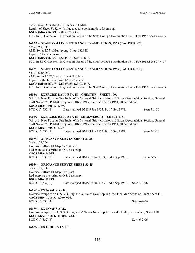
GSGS MISC SERIES © M.A. Nolan April 2007
113
Scale 1:25,000 or about 2 ½ Inches to 1 Mile. Reprint of Sheet SU32, with blue tactical overprint, 46 x 53 cms oa. GSGS (Misc) 1603/1. 2500/3/53. O.S. PCL In SE Collection. In Question Papers of the Staff College Examination 16-19 Feb 1953.Seen 29-4-05 1603/2 - STAFF COLLEGE ENTRANCE EXAMINATION, 1953 (TACTICS “C”) Scale 1:50,000. AMS Series L751, Mun’gyong, Sheet 6824 III. Reprint, 55 x 53 cms oa. GSGS (Misc) 1603/2. 2,500/3/53. S.P.C., R.E. PCL In SE Collection. In Question Papers of the Staff College Examination 16-19 Feb 1953.Seen 29-4-05 1603/3 - STAFF COLLEGE ENTRANCE EXAMINATION, 1953 (TACTICS “C”) Scale 1:250,000. AMS Series L552, Taejon, Sheet NJ 52-14. Reprint with blue overprint, 64 x 57cms oa. GSGS (Misc) 1603/3. 2,500/3/53. S.P.C., R.E. PCL In SE Collection. In Question Papers of the Staff College Examination 16-19 Feb 1953.Seen 29-4-05 1605/1 – EXERCISE BALLISTA III - CHESTER – SHEET 109. O.S.G.B. New Popular One-Inch (With National Grid) provisional Edition, Geographical Section, General Staff No. 4629. Published by War Office 1949. Second Edition 1951, all barred out. GSGS Misc. 1605/1. 1269. BOD C17(532)[1] Date-stamped DMS 9 Jan 1953, Bod 7 Sep 1981. Seen 3-2-06 1605/2 – EXERCISE BALLISTA III - SHREWSBURY – SHEET 118. O.S.G.B. New Popular One-Inch (With National Grid) provisional Edition, Geographical Section, General Staff No. 4629. Published by War Office 1949. Second Edition 1951, all barred out. GSGS Misc. 1605/2. 1277. BOD C17(532)[1] Date-stamped DMS 9 Jan 1953, Bod 7 Sep 1981. Seen 3-2-06 1605/3 – ORDNANCE SURVEY SHEET 33/35. Scale 1:25,000. Exercise Ballista III Map “X” (West). Red exercise overprint on O.S. base map. GSGS Misc 1605/3. BOD C17(532)[2] Date-stamped DMS 19 Jan 1953, Bod 7 Sep 1981. Seen 3-2-06 1605/4 – ORDNANCE SURVEY SHEET 33/45. Scale 1:25,000. Exercise Ballista III Map “X” (East). Red exercise overprint on O.S. base map. GSGS Misc 1605/4. BOD C17(532)[2] Date-stamped DMS 19 Jan 1953, Bod 7 Sep 1981. Seen 3-2-06 1618/3 – EX NOAHS ARK. Exercise overprint on O.S.G.B. England & Wales New Popular One-Inch Map Stoke on Trent Sheet 110. GSGS Misc. 1618/3. 6,000/7/52. BOD C17(532)[4] ` Seen 6-2-06 1618/4 – EX NOAHS ARK. Exercise overprint on O.S.G.B. England & Wales New Popular One-Inch Map Shrewsbury Sheet 118. GSGS Misc. 1618/4. 15,000/12/51. BOD C17(532)[4] ` Seen 6-2-06 1663/2 – EX QUICKSILVER.

GSGS MISC SERIES © M.A. Nolan April 2007
114
Scale 1/253,440. Exercise overprint on GSGS 4628 Sheet 3 Sixth Edition. 5,000/5/53. O.S. G.S.G.S. Misc. 1663/2. BOD C17(532)[8] Seen 6-2-06 1663/4 – EX QUICKSILVER. Scale 1/253,440. Exercise overprint on GSGS 4628 Sheet 6 Fifth Edition. G.S.G.S. Misc. 1663/4. BOD C17(532)[8] Seen 6-2-06 1663/5 – EX QUICKSILVER. Scale 1/63,360. Exercise overprint on GSGS 4620 Sheet 91 Second Edition. 20,000/12/52. G.S.G.S. Misc. 1663/5. BOD C17(532)[8] Seen 6-2-06 1663/6 – EX QUICKSILVER. Scale 1/63,360. Exercise overprint on GSGS 4620 Sheet 92 Second Edition. 15,000/6/52. G.S.G.S. Misc. 1663/6. BOD C17(532)[8] Seen 6-2-06 1663/7 – EX QUICKSILVER. Scale 1/63,360. Exercise overprint on GSGS 4620 Sheet 96 Second Edition. 15,000/1/52. G.S.G.S. Misc. 1663/7. BOD C17(532)[8] Seen 6-2-06 1663/8 – EX QUICKSILVER. Scale 1/63,360. Exercise overprint on GSGS 4620 Sheet 97 Second Edition. 15,000/1/52. G.S.G.S. Misc. 1663/8. BOD C17(532)[8] Seen 6-2-06 1640/1 - STAFF COLLEGE ENTRANCE EXAMINATION 1954 (TACTICS “B”) – MAP “A”. Scale One Inch to One Statute Mile = 1/63,360. A Sheet 178 GSGS 4620 Second Edition base map. Geographical Section General Staff Misc. No. 1640/1. 15,000/11/53. O.S. PCL SE Collection. In, Question Papers of the Staff College Camberley Entrance Examination,
15-18 Feb 1954. Seen 29-4-05 1640/2 - STAFF COLLEGE ENTRANCE EXAMINATION – 1954 (TACTICS “B”) – MAP “B”. Scale 1:25,000 or about 2 ½ Inches to 1 Mile. Reprint of Parts of sheets SY 69 and SY 79, 48 x 55 cms oa. Geographical Section General Staff Misc. 1640/2. 5,000/11/53. O.S. PCL SE Collection. In, Question Papers of the Staff College Camberley Entrance Examination,
15-18 Feb 1954. Seen 29-4-05 1640/3 – STAFF COLLEGE ENTRANCE EXAMINATION 1954 – (TACTICS “C”) – MAP A – TAKKA CITY AND TOWNSHIP. Scale 1:25,000. Black and brown town plan with brown one kilometre arbitrary grid, 45 x 41 on 47 x 50 cms oa. Legend. Geographical Section, General Staff, Misc. No. 1640/3. 5,000/11/53 S.P.C., R.E. PCL SE Collection. In, Question Papers of the Staff College Camberley Entrance Examination,
15-18 Feb 1954. Seen 29-4-05

GSGS MISC SERIES © M.A. Nolan April 2007
115
1640/4 – STAFF COLLEGE ENTRANCE EXAMINATION 1954 – (TACTICS “C”) – MAP “B” – OBO. Scale 1 Inch = 200 Yards. Black, brown, blue, green village plan with no 40 x 29 on 42 x 41 cms oa. Key. G.S.G.S. Misc. No. 1640/4. 5,000/11/53 O.S. Reproduced by Ordnance Survey, 1953. PCL SE Collection. In, Question Papers of the Staff College Camberley Entrance Examination,
15-18 Feb 1954. Seen 29-4-05 1653 - AVON APPROACHES AND LARKHILL TRAINING AREA – FIRST EDITION. Ordnance Survey Salisbury Plain Sheet 157 with military overprint. Geographical Section, General Staff, Misc. No. 1653. Published by War Office, 1954. First Edition – GSGS 1954. 7,000/4/54. O.S. PRO WO 231/78 Seen 20-4-04 1662/1 - STAFF COLLEGE ENTRANCE EXAMINATION – 1955 (TACTICS “C”). SKETCH OF AREA PENANG, PROVINCE WELLESLEY AND N.W. PERAK. Scale 1:1,000,000. Black and red outline map of area including Ipoh, Grik, Buterworth, 17.5 x 29 on 20 x 32.5 cms oa. GSGS. Misc. 1662/1. W/28/5,500/54. RAHT Misc Dardanelles etc box Seen 13-7-04 1662/2 - STAFF COLLEGE ENTRANCE EXAMINATION – 1955 (TACTICS “C”) – PERAK – PARTS OF SELAMA, LARUT AND UPPER PERAK DISTRICT – THIRD EDITION. Scale 1 Inch to a Mile or 1:63,360. Base map, Printed at the Survey of India Offices (P.Z.O.) Reg. No. 663 X.D.D.’43 (5 D.O.-1)-X’43.-X’45. GSGS Misc. 1662/2. 5,500/10/54 S.P.C. R.E. RAHT Misc Dardanelles etc box Seen 13-7-04 1662/3 - STAFF COLLEGE ENTRANCE EXAMINATION – 1955 (TACTICS “B”) – MAP “B” – EDITION 1-GSGS – SHEET NZ17. Scale 1:5,000. O.S. Sheet NZ17. Base map, Reprinted with corrections 1950. Geographical Section, General Staff No. 4627. Published by War Office 1954. Edition 1-GSGS 1954. GSGS Misc. 1662/3. 5,500/11/54 S.P.C. R.E. RAHT Misc Dardanelles etc box Seen 13-7-04 PCL In SE Collection. Seen 26-4-05 Copied to GSGS Misc. 1662/4 - STAFF COLLEGE ENTRANCE EXAMINATION – 1955 (TACTICS “B”) – MAP “A”. Scale One Inch to One Statute Mile = 1/63,360. A Sheet 78 GSGS 4620 Second Edition base map. Geographical Section, General Staff No. 4620. Published by War Office 1953. Second Edition – GSGS 1953. GSGS Misc. 1662/4. PCL In SE Collection. Seen 26-4-05 Copied to GSGS Misc. 1662/1 - STAFF COLLEGE ENTRANCE EXAMINATION – 1955 (TACTICS “C”) – SKETCH OF AREA PENANG, PROVINCE WELLESLEY AND N.W. PERAK. Scale 1:1,000,000. Black and red sketch map centred on Penang Island, 20 x 32 cms oa. GSGS. Misc. 1662/1. W/28/5,500/54. PCL In SE Collection. Seen 26-4-05 Copied to GSGS Misc.

GSGS MISC SERIES © M.A. Nolan April 2007
116
1662/2 - STAFF COLLEGE ENTRANCE EXAMINATION – 1955 (TACTICS “C”) – PERAK – THIRD EDITION. Scale 1 Inch To a Mile or 1:63,360. A Hind 1035, 3rd Edition, 1945, March with additions and correction, etc map. GSGS Misc. 1662/2. W/28/5,500/54. 5,500/10/54 SPC, RE. PCL In SE Collection. Seen 26-4-05 Copied to GSGS Misc. PLATE VII. Black, brown, blue, red, map extract from GSGS No. 4639 Sheet 9 Scale 1:63,360 of Loch Eriboll area showing example of vertical and oblique sortie plotting, 17 x 29 on 20 x 39.5 cms oa. GSGS MISC 1701/7. No. 2 SPC (AIR) 32,600/6/58.371. In, Manual of Map reading and Field Sketching Part II Air Photo Reading 1958, W.O. Code No. 9484. Seen 27-1-06 1705 - STAFF COLLEGE ENTRANCE EXAMINATION – 13th FEBRUARY, 1956 – MAP “A” – EDITION 2 - G.S.G.S. Scale : One Centimetre to .6336 of a Kilometre. Black overprint on Series GSGS 4620 Sheet 156 Edition 2 one-inch map of Oxford – Newbury area, 72 x 89 cms oa. GSGS (Misc) 1705. 5,500/11/55 O.S. Overprint drawn and printed by O.S. 1955. PCL In SE Collection. Seen 26-4-05 Copied to GSGS Misc. 1706 - STAFF COLLEGE ENTRANCE EXAMINATION – 13th FEBRUARY, 1956 – MAP “B” – SECOND EDITION G.S.G.S. Scale 1:25,000 or about 2 ½ Inches to 1 Mile. Reprint of Sheet SU58 (41/58), 47 x 60.5 cms oa. GSGS (Misc) 1706. Overprint drawn and printed by O.S. 1955. 5,500/11/55. O.S. PCL In SE Collection. Seen 26-4-05 Copied to GSGS Misc. 1707 - STAFF COLLEGE ENTRANCE EXAMINATION 14TH FEBRUARY, 1956 – TACTICS “C” – SKETCH OF GOLOLAND, EASTERN REGION – MAP “A”. Scale. On scale 20 miles = 2.5 ins. Fictional, monochrome sketch map, 34 x 43.5 cms oa. G.S.G.S. Misc. 1707. 5500/10/55/. No. 2 S.P.C. (AIR). PCL In SE Collection. Two copies. Seen 26-4-05 Copied to GSGS Misc. 1709 – ORDNANCE SURVEY OF GREAT BRITAIN – ENGLAND SOUTH – EDITION 1-GSGS – Parts of Sheets 7, 8, 9, 11 & 12. Refer to this map as : - GSGS (Misc) 1709 Edition 1. O.S. Quarter-Inch to One Mile based map of the area from 3-16W to 0-15E & 50-30 to 52-03N, with black 10 km grid and blue values, 98 x 69 on 108 x 84.5 cms oa. Geographical Section, General Staff, (Misc) No. 1709. Published by War Office, 1955. Edition 1 – GSGS 1955. Printed for D. Survey (WO and AM) by Ordnance Survey. 11,000/2/62/6377/OS. BOD C17:7(70) Date-stamped DMS 19 Mar 1962. Seen 3-2-06 1768 - GUERNSEY 1:50,000 – U.T.M. GRID – GUERNSEY – EDITION 1-GSGS. Scale 1:50,000 or about 1.27 Inches to One Statute Mile. SSD Box – Refer to this map as GSGS (Misc) 1768 Guernsey. Black, brown, blue, red, green map of the area from 2-29-30 to 2-41-50W & 49-24-40 to 49-31-20N approx with 1 minute divisions and 5 minute values round the border, black grid from 522,000 to 537,000mE & 5473,000 to 5486,000mN; 30 x 26 on 36.5 x 40.5 cms oa. Reference – 1st Roads. 2nd Roads. Other Roads.
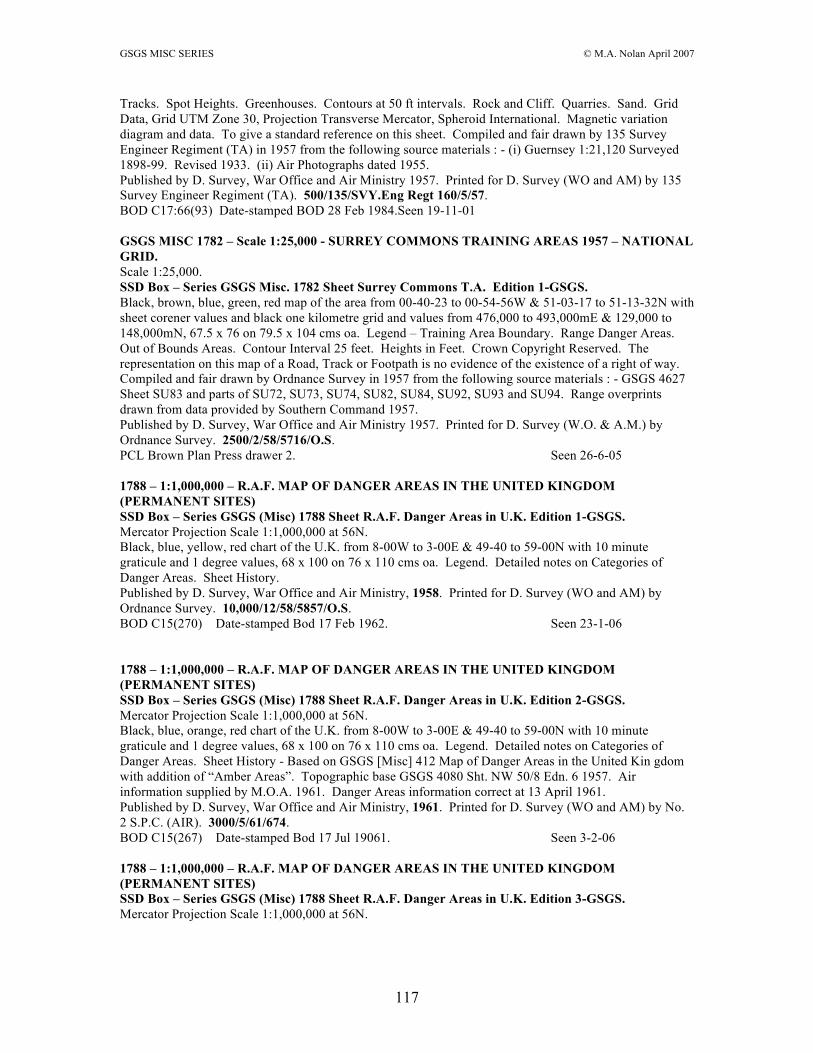
GSGS MISC SERIES © M.A. Nolan April 2007
117
Tracks. Spot Heights. Greenhouses. Contours at 50 ft intervals. Rock and Cliff. Quarries. Sand. Grid Data, Grid UTM Zone 30, Projection Transverse Mercator, Spheroid International. Magnetic variation diagram and data. To give a standard reference on this sheet. Compiled and fair drawn by 135 Survey Engineer Regiment (TA) in 1957 from the following source materials : - (i) Guernsey 1:21,120 Surveyed 1898-99. Revised 1933. (ii) Air Photographs dated 1955. Published by D. Survey, War Office and Air Ministry 1957. Printed for D. Survey (WO and AM) by 135 Survey Engineer Regiment (TA). 500/135/SVY.Eng Regt 160/5/57. BOD C17:66(93) Date-stamped BOD 28 Feb 1984.Seen 19-11-01 GSGS MISC 1782 – Scale 1:25,000 - SURREY COMMONS TRAINING AREAS 1957 – NATIONAL GRID. Scale 1:25,000. SSD Box – Series GSGS Misc. 1782 Sheet Surrey Commons T.A. Edition 1-GSGS. Black, brown, blue, green, red map of the area from 00-40-23 to 00-54-56W & 51-03-17 to 51-13-32N with sheet corener values and black one kilometre grid and values from 476,000 to 493,000mE & 129,000 to 148,000mN, 67.5 x 76 on 79.5 x 10⁴ cms oa. Legend – Training Area Boundary. Range Danger Areas. Out of Bounds Areas. Contour Interval 25 feet. Heights in Feet. Crown Copyright Reserved. The representation on this map of a Road, Track or Footpath is no evidence of the existence of a right of way. Compiled and fair drawn by Ordnance Survey in 1957 from the following source materials : - GSGS 4627 Sheet SU83 and parts of SU72, SU73, SU74, SU82, SU84, SU92, SU93 and SU94. Range overprints drawn from data provided by Southern Command 1957. Published by D. Survey, War Office and Air Ministry 1957. Printed for D. Survey (W.O. & A.M.) by Ordnance Survey. 2500/2/58/5716/O.S. PCL Brown Plan Press drawer 2. Seen 26-6-05 1788 – 1:1,000,000 – R.A.F. MAP OF DANGER AREAS IN THE UNITED KINGDOM (PERMANENT SITES) SSD Box – Series GSGS (Misc) 1788 Sheet R.A.F. Danger Areas in U.K. Edition 1-GSGS. Mercator Projection Scale 1:1,000,000 at 56N. Black, blue, yellow, red chart of the U.K. from 8-00W to 3-00E & 49-40 to 59-00N with 10 minute graticule and 1 degree values, 68 x 100 on 76 x 110 cms oa. Legend. Detailed notes on Categories of Danger Areas. Sheet History. Published by D. Survey, War Office and Air Ministry, 1958. Printed for D. Survey (WO and AM) by Ordnance Survey. 10,000/12/58/5857/O.S. BOD C15(270) Date-stamped Bod 17 Feb 1962. Seen 23-1-06 1788 – 1:1,000,000 – R.A.F. MAP OF DANGER AREAS IN THE UNITED KINGDOM (PERMANENT SITES) SSD Box – Series GSGS (Misc) 1788 Sheet R.A.F. Danger Areas in U.K. Edition 2-GSGS. Mercator Projection Scale 1:1,000,000 at 56N. Black, blue, orange, red chart of the U.K. from 8-00W to 3-00E & 49-40 to 59-00N with 10 minute graticule and 1 degree values, 68 x 100 on 76 x 110 cms oa. Legend. Detailed notes on Categories of Danger Areas. Sheet History - Based on GSGS [Misc] 412 Map of Danger Areas in the United Kin gdom with addition of “Amber Areas”. Topographic base GSGS 4080 Sht. NW 50/8 Edn. 6 1957. Air information supplied by M.O.A. 1961. Danger Areas information correct at 13 April 1961. Published by D. Survey, War Office and Air Ministry, 1961. Printed for D. Survey (WO and AM) by No. 2 S.P.C. (AIR). 3000/5/61/674. BOD C15(267) Date-stamped Bod 17 Jul 19061. Seen 3-2-06 1788 – 1:1,000,000 – R.A.F. MAP OF DANGER AREAS IN THE UNITED KINGDOM (PERMANENT SITES) SSD Box – Series GSGS (Misc) 1788 Sheet R.A.F. Danger Areas in U.K. Edition 3-GSGS. Mercator Projection Scale 1:1,000,000 at 56N.

GSGS MISC SERIES © M.A. Nolan April 2007
118
Black, blue, yellow, red chart of the U.K. from 8-00W to 3-00E & 49-40 to 59-00N with 10 minute graticule and 1 degree values, 68 x 100 on 76 x 110 cms oa. Legend. Detailed notes on Categories of Danger Areas. Sheet History. Published by D. Survey, War Office and Air Ministry, 1961. Printed for D. Survey (WO and AM) by No 2 S.P.C. (Air). 2000/11/61/717. BOD C15(270) Date-stamped Bod 17 Feb 1962. Seen 23-1-06 1820 – ORDNANCE SURVEY “TEN MILE” MAP OF GREAT BRITAIN – SHEET 1. Scale : 1/625,000 or about Ten Miles to One Inch SSD Box – Series GSGS (Misc) 1820 Sheet 1 Edition 1-GSGS. Layered, grey, blue, buff, sienna map of southern Great Britain, north of Richmond (Yorks), 99 x 78 on 107 x 84 cms oa. Published by D. Survey, Ministry of Defence United Kingdom, 1964. Reproduced from the Ordnance Survey Ten Mile map dated 1955. Printed for D. Survey, Ministry of Defence United Kingdom by Ordnance Survey. 750/9/64/6654/OS. BOD C16(429) Date-stamped Bod 12 Jan 1981. Seen 25-1-06 1820 – ORDNANCE SURVEY “TEN MILE” MAP OF GREAT BRITAIN – SHEET 2. Scale : 1/625,000 or about Ten Miles to One Inch SSD Box – Series GSGS (Misc) 1820 Sheet 2 Edition 1-GSGS. Layered, grey, blue, buff, sienna map of southern Great Britain, south of Scarborough, 99 x 78 on 107 x 84 cms oa. Published by D. Survey, Ministry of Defence United Kingdom, 1964. Reproduced from the Ordnance Survey Ten Mile map dated 1955. Printed for D. Survey, Ministry of Defence United Kingdom by Ordnance Survey. 750/9/64/6654/OS. BOD C16(429) Date-stamped Bod 12 Jan 1981. Seen 25-1-06 1806 - UNTITLED MAP OF CYPRUS FOR RECRUITING PURPOSES. 1:500,000. Layered map of Cyprus with inset Survey Service Recruiting Note; 44 x 39.5 on 46.5 x 53.5 cms oa. GSGS Misc. 1806. Printed by 13 Fd Svy Sqn RE, 1957. Copy held by R.S.M.S. 1809/1 – GREAT BRITAIN – PART OF SHEET 23/77 (SH 77) PROVISIONAL EDITION – PLATE 10. Scale 1/25,000. Map extract map sample of Conway area, 12 x 20 on 36 x 27 cms oa. Notes on Plate 11. GSGS Misc. 1809/2. In, Textbook of Topographical Surveying, H.M.S.O. 1965, Army Code No. 12738. 26/Publications/6532. 1809/2 – FRANCE - PART OF SHEET XXI/46-2 1948 – PLATE 11. Scale 1/20,000. Map extract map sample of Pamiers area, 12 x 20 on 36 x 27 cms oa. Notes on Plate 11. GSGS Misc. 1809/1. In, Textbook of Topographical Surveying, H.M.S.O. 1965, Army Code No. 12738. 26/Publications/6532. 1809/3 – GERMANY – PART OF SHEET 4407 1955 - PLATE 12. Scale 1/25,000. Map extract map sample of Elling area, 12 x 20 on 36 x 27 cms oa. Notes on Plate 12. GSGS Misc. 1809/3. In, Textbook of Topographical Surveying, H.M.S.O. 1965, Army Code No. 12738. 26/Publications/6532. 1809/? – SWITZERLAND - PART OF SHEET 1106 1955 – PLATE 13. Scale 1:25,000. Map extract map sample of Moutier area, 12 x 20 on 36 x 27 cms oa. Notes on Plate 13. No GSGS Misc. number.

GSGS MISC SERIES © M.A. Nolan April 2007
119
In, Textbook of Topographical Surveying, H.M.S.O. 1965, Army Code No. 12738. 26/Publications/6532. 1809/4 – FRANCE – PART OF SHEET XXI/46 1950 – PLATE 14. Scale 1/50,000. Map extract map sample of Pamiers area, 12 x 20 on 36 x 27 cms oa. Notes on Plate 14. GSGS Misc. 1809/4. In, Textbook of Topographical Surveying, H.M.S.O. 1965, Army Code No. 12738. 26/Publications/6532. 1809/5 – GREAT BRITAIN – PART OF SHEET 107 1953 – PLATE 15. Scale : 1 inch to 1 mile. Map extract map sample of Conway area, 12 x 20 on 36 x 27 cms oa. Notes on Plate 15. GSGS Misc. 1809/5. In, Textbook of Topographical Surveying, H.M.S.O. 1965, Army Code No. 12738. 26/Publications/6532. 1809/6 – INDIA – PART OF SHEET 72 D/10 1934 (2ND EDITION, GRIDDED) – PLATE 16. Scale : 1 inch to 1 mile. Map extract map sample of Dumrawan area, 12 x 20 on 36 x 27 cms oa. Notes on Plate 16. GSGS Misc. 1809/6. In, Textbook of Topographical Surveying, H.M.S.O. 1965, Army Code No. 12738. 26/Publications/6532. 1824 – INDEX DIAGRAM OF SHEETS FOR THE INTERNATIONAL MAP ON THE SCALE OF 1:1,000,000 – PLATE 9. Black and red diagrams of the northern and southern hemispheres, each 20 cms in diameter, showing in red the sheet lettering and numbering system, on page 44 x 27 cms oa. GSGS Misc. 1824. In, Textbook of Topographical Surveying, H.M.S.O. 1965, Army Code No. 12738. 26/Publications/6532. 1830 - HADHRAMAUT 1/100,000 – WADI JARDAN – SHEET (D38) L N.W. Scale 1:100,000. Monochrome map of the area from 46-55 to 47-30E & 14-30 to 15-00N with sheet corner only geographical values; black 10 kilometre grid and values; 63 x 55 on 75 x 68.5 cms oa. Reference – Main Motorable Tracks. Car Routes. Camel Routes. Other Tracks. U.T.M. Grid. GSGS (Misc) 1830 60/7/58/1.SPC/3903/R. BOD D63:4(3) Date-stamped SPC Proof 22 Jul 1958. Seen 1-3-02 1830 - HADHRAMAUT 1/100,000 – YEBETH – SHEET (D38) L N.E. Scale 1:100,000. Monochrome map of the area from 47-30 to 48-00E & 14-30 to 15-00N with sheet corner only geographical values; black 10 kilometre grid and values; 53.5 x 55.5 on 61 x 69 cms oa. Reference – Main Motorable Tracks. Car Routes. Camel Routes. Other Tracks. U.T.M. Grid. GSGS (Misc) 1830 60/7/58/1.SPC/3903/R. BOD D63:4(3) Date-stamped SPC Proof 22 Jul 1958. Seen 1-3-02 1830 - HADHRAMAUT 1/100,000 – RAWDAH – SHEET (D38) L S.W. Scale 1:100,000. Monochrome map of the area from 46-55 to 47-30E & 14-00 to 14-30N with sheet corner only geographical values; black 10 kilometre grid and values; 63 x 55 on 75 x 68.5 cms oa. Reference – Main Motorable Tracks. Car Routes. Camel Routes. Other Tracks. U.T.M. Grid. GSGS (Misc) 1830 60/7/58/1.SPC/3903/R. BOD D63:4(3) Date-stamped SPC Proof 22 Jul 1958. Seen 1-3-02 1830 - HADHRAMAUT 1/100,000 – HAWRA – SHEET (D38) L S.E. Scale 1:100,000. Monochrome map of the area from 47-30 to 48-00E & 13-49 to 14-30N with sheet limits only geographical values; black 10 kilometre grid and values; 54 x 76.5 on 61.5 x 87 cms oa. Reference – Main Motorable Tracks. Car Routes. Camel Routes. Other Tracks. U.T.M. Grid. GSGS (Misc) 1830 60/7/58/1.SPC/3903/R.

GSGS MISC SERIES © M.A. Nolan April 2007
120
BOD D63:4(3) Date-stamped SPC Proof 22 Jul 1958. Seen 1-3-02 GSGS MISC 1979 - GOODWOOD. FRANCE 1:25,000, COMPOSITE SHEET (Parts of Sheets Nos. 40/16 N.W., N.E., S.W. & S.E. Multicoloured, layered map of the Operation Goodwood breakout operation in Normandy in 1944. GSGS Misc. 1979 Edition 1. Trimmed on esastern side. Copy held by R.S.M.S. 2045. BL 5615.(3.) NYS BL MAPS PR INDEX 5./2.TA NYS 2133 – ABERYSTWYTH – SHOWING C.C.F. ARDUOUS TRAINING AREAS (cleared by DLA(A)) PLYNLIMMON. SSD Box – Series M722 Sheet 127 Edition 3-GSGS (barred out). GSGS MISC. 2133. Red overprint on O.S. of G.B. One-Inch map (Seventh Series. Overprinted by SPC. RE. 50/10/66/1822/SPC. BOD C17:18(5) Date-stamped DMS 25 Oct 1966, Bod 30 Jun 1981. Seen 3-2-06 2158/1 - STAFF/PROMOTION EXAMINATION 1967 – TACTICS “B” – MAP “A”. Scale not stated, but, One Inch to One Statute Mile = 1/63,360. Black, overprint on one-inch map of Aldershot – Haslemere area, 45 x 86 cms oa. GSGS MISC 2158/1. Printed by SPC, R.E. 1800/8/67/2093/SPC. PCL In SE Collection. Seen 26-4-05 Copied to GSGS Misc. 2158/2 - STAFF/PROMOTION EXAMINATION, 1967 – TACTICS “B” MAP “B”. Scale not stated, but, 1:25,000 or about 2 ½ Inches to 1 Mile. Purple and green overprint on 1:25,000 sheet/s of the Godalming – Witley area, 50 x 69 cms oa. GSGS MISC 2158/2. Printed by SPC R.E. 1800/8/67/2093/SPC. PCL In SE Collection. Seen 26-4-05 Copied to GSGS Misc. 2163 - STAFF/PROMOTION EXAMINATION 1967 – TACTICS “C” - MAP “A”. Scale 1:50,000. Black and brown map extract of Lere and Sogal Island, 60 x 49 cms oa. Drawings supplied by GS Map Section 1967. GSGS MISC 2163. Printed by SPC, RE. 4000/10/67/2175/SPC. PCL In SE Collection. Seen 26-4-05 Copied to GSGS Misc. 2175 - STAFF/PROMOTION EXAMINATION 1968 – TACTICS B – MAP A. Blue overprint on on-inch base map of Newbury – Oxford area, 70.5 x 93 cms oa. GSGS/MISC/2175. Printed by SPC, RE. 5/68/488/SPC. PCL In SE Collection. Seen 26-4-05 Copied to GSGS Misc. 2176 - STAFF/PROMOTION EXAMINATION 1968 – TACTICS B - MAP B. Scale 1:25,000 or about 2 ½ Inches to 1 Mile. Blue, green and magenta overprint on map of the Lambourn, Hungerford, West Woodhay area, 59.5 x 97 cms oa. GSGS/MISC/2176. Printed by SPC, RE. 9/68/489/SPC. PCL In SE Collection. Seen 26-4-05 Copied to GSGS Misc.

GSGS MISC SERIES © M.A. Nolan April 2007
121
2177 - STAFF/PROMOTION EXAMINATION 1968 – ANGST - TACTICS “C” - MAP A Scale 1:250000. Blue overprint on layered map of Kampala area, 76 x 61 cms oa. GSGS/M/2177. Printed by The Survey Production Centre, RE. 9/68/490/SPC. PCL In SE Collection. Seen 26-4-05 Copied to GSGS Misc. 2213 - STAFF/PROMOTION EXAMINATION DECEMBER 1969 – TACTICS “B” - MAP “B” Scale One Inch to One Statute Mile = 1/63,360. Black and blue overprint on Series M722 base map of Bishop Auckland area, 49 x 61 cms oa. GSGS Misc. 2213. Printed by SPC, RE. 9/69/1509/SPC. PCL In SE Collection. Seen 26-4-05 Copied to GSGS Misc. 2213/A - STAFF/PROMOTION EXAMINATION DECEMBER 1969 – TACTICS “B” – ANNEX “A” TO MAP “B” – MINES OVERLAY. Scale not stated, presumably, One Inch to One Statute Mile = 1/63,360. Green mines overlay printed on tracing paper, 48 x 61 cms oa. GSGS Misc. 2213/A. 9/69/1510/SPC. PCL In SE Collection. Seen 26-4-05 Copied to GSGS Misc. 2214 - STAFF/PROMOTION EXAMINATION – DECEMBER 1969 – TACTICS “B” – MAP “A”. Scale One Inch to One Statute Mile = 1/63,360. Black, blue, red overprint on Series M722, one-inch map of Bishop Auckland – Darlington area, 59 x 114 . GSGS Misc. 2214. Printed by SPC, RE. 9/69/1508/SPC. PCL In SE Collection. Seen 26-4-05 Copied to GSGS Misc. 2228/1 - STAFF/PROMOTION EXAMINATION 1969 – TACTICS C - MAP A - SANKA. 1:63,360. Fictionalised extract from an African sheet, 88 x 67 cms oa. GSGS Misc 2228/1. Printed by SPC, RE. 9/69/1465/SPC. PCL In SE Collection. Seen 26-4-05 Copied to GSGS Misc. 2228/2 - STAFF/PROMOTION EXAMINATION DECEMBER 1969 – TACTICS C - MAP A – SHEET 2 - SANKA. Scale 1:63,360. Extract from an African sheet, 69 x 88 cms oa. GSGS Misc 2228/2. Printed by SPC, RE. 9/69/1464/SPC. PCL In SE Collection. Seen 26-4-05 Copied to GSGS Misc. 2228/3 - STAFF/PROMOTION EXAMINATION DECEMBER 1969 – TACTICS C - MAP B – SANKA CITY. Scale 1:5,000. Extract from an African sheet, 88 x 96 cms oa. GSGS Misc 2228/3. Printed by SPC, RE. 9/69/1466/SPC. PCL In SE Collection. Seen 26-4-05 Copied to GSGS Misc. See also Corps History reprint maps, for example : -

GSGS MISC SERIES © M.A. Nolan April 2007
122
GSGS MISC 2439/1 - THE BATTLE OF DOJRAN 18TH SEPTEMBER 1918 – SKETCH 6. Scale. 1 mile = 2 ins. (1:31,680) Black, buff, blue, red, green map 22 x 16 on 37 x 22 cms oa. Line Consolidated. British – Red. Greek – Blue. Bulgarian – Green. GSGS Misc 2439/1. Crown Copyright Reserved. Compiled in the Historical Section (Military Branch) 3540. Ordnance Survey 1937. Printed by MCE (RE) 2/73/730296M. Corps History Vol ?? STAFF/PROMOTION EXAMINATION 1967 – TACTICS “C” MAP “B”. Scale : - 1:25,000. Extract covering the Lere area, 31 x 28 on 46 x 35 cms oa. No designation, production note or imprint. PCL In SE Collection. Seen 26-4-05 Copied to GSGS Misc. STAFF/PROMOTION EXAMINATION 1968 – TACTICS “C” - MAP “B” – Scale 1:25,000. A map of somewhere in Africa, 58 x 44 cms oa. Designation probably lost in word processing. 8/68/491/SPC. PCL In SE Collection. 46TH NORTH MIDLAND DIVISION T.A. 1933. Scale – Six Inches to One Statute Mile or 880 Feet to One Inch = 1/10,560. Black and red O.S. base map of area north of Pwllheli, 92 x 60 on 94 xc 64.5 cms oa. Reference – Boundary of Training Area, Sub Area, Camp Areas. Fields “Out of Bounds”. Special Instructions. Crown Copyright Reserved. 100/33. Ordnance Survey, 1933. BOD C16(6) Annotated, [G.S. No. 3946]. Date-stamped GSGS 9 Aug 1953Bod 30 Jun 1981. Seen 3-2-06 Copied to GSGS 3901+ C.B. 4096Q – ALESUND TO NARVIK COMMUNICATIONS AND COAST – FEBRUARY 1942. Scale 1:1,000,000 Black, blue, red road map of the area from 5-00 to 17-00E & 62-00 to 68-30N with 2 degree graticule and values. Reference – State roads. Country roads. Local roads. Roads under construction. Railways. Route number in Road Report. Route number in Railway report. Inter-Service Topographical Department. BOD C36(138) Date-stamped GSGS 18 Jun 1942. Seen 14-11-05