Embed Size (px)
Citation preview
8/3/2019 G_Seismic & Geologic Hazards Existing Conditions Report
http://slidepdf.com/reader/full/gseismic-geologic-hazards-existing-conditions-report 1/54
Seismic & Geologic HazardsExisting Conditions Report
Appendix G:General Plan Update
8/3/2019 G_Seismic & Geologic Hazards Existing Conditions Report
http://slidepdf.com/reader/full/gseismic-geologic-hazards-existing-conditions-report 2/54
SEISMIC AND GEOLOGIC HAZARDS REVIEW
GENERAL PLAN UPDATE
CITY OF MURRIETA, CALIFORNIA
Prepared For:
CITY OF MURRIETAc/o RBF Consulting
14725 Alton ParkwayIrvine, CA 92618
Project No. 602728-001
January 8, 2010
8/3/2019 G_Seismic & Geologic Hazards Existing Conditions Report
http://slidepdf.com/reader/full/gseismic-geologic-hazards-existing-conditions-report 3/54
January 8,20 10
Project No. 602728-001
CITY OF MUR RIETA
C/ORBF Consulting
14725 Alton Parkway
Irvine, C A 926 18
Attention: Ms. Collette L. Morse, AICP, Vice President
Subject: Seismic and Geologic Haz ards ReviewGeneral Plan Update, City of Murrieta, California
In accordance with your authorization and our proposal dated June 26, 2009, we have performed
a seismic and geologic hazard s review for -the City of Murrieta (City) in support of the G eneral
Plan Update. This report summarizes our findings and provides general recommendations related
to potential seismic and geologic hazards within the City. Future land developm ents within the
City limits appear feasible from a seismic/geologic viewpoint provided independent, site-specific
evaluations are performed to address the general concerns and constraints outlined in this report.
If you have any questions regarding this report, please do not hesitate to contact the undersigned.
We appreciate this opportunity to be of service on this project.
Respectfully submitted,
LEIGHTOIV CONSULTIIVG, INC.
G E 264.1 (Exp. 09/30
Principal Engineer
Robert F. Riha
RFR/SIS/dlm
Distribution: (4 ) Addressee (plus C D copy)
8/3/2019 G_Seismic & Geologic Hazards Existing Conditions Report
http://slidepdf.com/reader/full/gseismic-geologic-hazards-existing-conditions-report 4/54
Seismic and Geologic Hazards Review 602728-001
Otyof Murrieta. California Januay 8,201
T A B L E O F C O N T E N T S
Section
1.0 I N T R O D U C T I O N ...................................................................................................
........................................................................................................................ Purpose and Scope 11.2 City Location and General Description ....................................................................................... 2
2.0 G E O L O G Y ................................................................................................................. 3
2.1 Regional Settings ......................................................................................................................... 3
2.2 Area Geology ..............................................................................................................................
2.3 Site-Specific Geology (Areas 1 through 3) ................................................................................. 5
.................................................................................................................................4 Groundwater 6
2.5 Geologic Hazards ......................................................................................................................... 7
2.5.1 Expansive Soils ..................................................................................................................................72.5.2 Collapse Soils ................................................................................................................................... 7
.............................................................................................................................5.3 Loading Settlement 8
............................................................................................................................................-54 Subsidence 8
..............................................................................................................5.5 Hazardous Mherals/Radon 8
3.0 S E I S M I C I T Y A N D F A U L T I N G .......................................................................10
3.1 General ....................................................................................................................................... 10
3.2 Fault Rupture ............................................................................................................................. 1 13.3 Ground Shaking ..............................................................................................: .................... II
. .3 .4 Secondary Seisrn~c azards ....................................................................................................... 14
...........................................................4.1 Dynamic Settlement/ Liquefaction and "DrynSettlement 14
................................................................................................................................4.2 Lateral Spreading 14
..............................................................................4.3 Differential Subsidence and Ground Fissuring 15
3.4.4 Seiches and Tsunamis..................................................................................................................5
.......................................................................................................................................4.5 Flooding .. 15
..........................................................................................................................................4.6 Landslides 15
.............................................................................................................................4.7 Rock Fall Hazards 16
4.0 G R A D I N G A N D D E S I G N C O N S I D E R A T I O N S ........................................ 17
4.1 General ....................................................................................................................................... 17
4.2 Grading and Earthwork Considerations ..................................................................................... 17
4.2.1 Site Preparation.................................................................................................................................7
4.2.2 Remedial Grading ............................................................................... .............................. 17
4.2.3 Suitability of Native Soils for Fills...............................................................................................9..........................................................................................2.4 Shrinkage and Bulking Considerations 19
8/3/2019 G_Seismic & Geologic Hazards Existing Conditions Report
http://slidepdf.com/reader/full/gseismic-geologic-hazards-existing-conditions-report 5/54
Seismic and Geologic Hazards Re view 602728-001
City of Murrieta, Cahfornia January 8,201
4.3 Foundation Design .....................................................................................................................04.4 Soil Corrosivity and Sulfate Attack ...........................................................................................1
5.0 S I T E - S P E C I F I C S T U D I E S ............................................................................... 2
5.1 Geotechnical / Geologic Evaluation ..........................................................................................25.2 Fault Investigation ......................................................................................................................2
6.0 L I M I T A T I O N S ................................................................................................... 23
ACCOMPAN YING TABLES, FIGURES, FIGURES AND APPENDICES
Tables
Table 1. 2007 CBC Site-Specific Seismic Coefficients - Area I ........................................ 12
Table 2. 2007 CBC Site-Specific Seismic Coefficients - Area 2 ..................................... 13
Table 3. 2007 CBC Site-Specific Seismic Coe fficients - Area 3 ............................................. 13
Fiqures End of Text
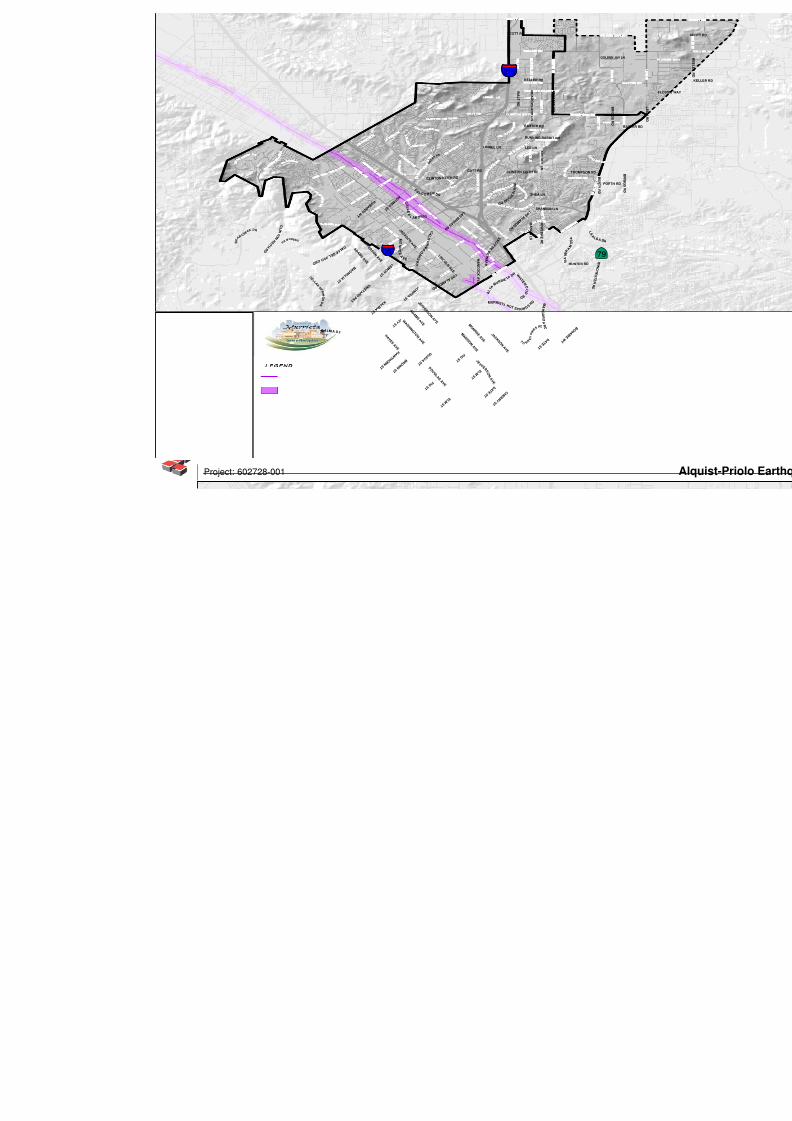
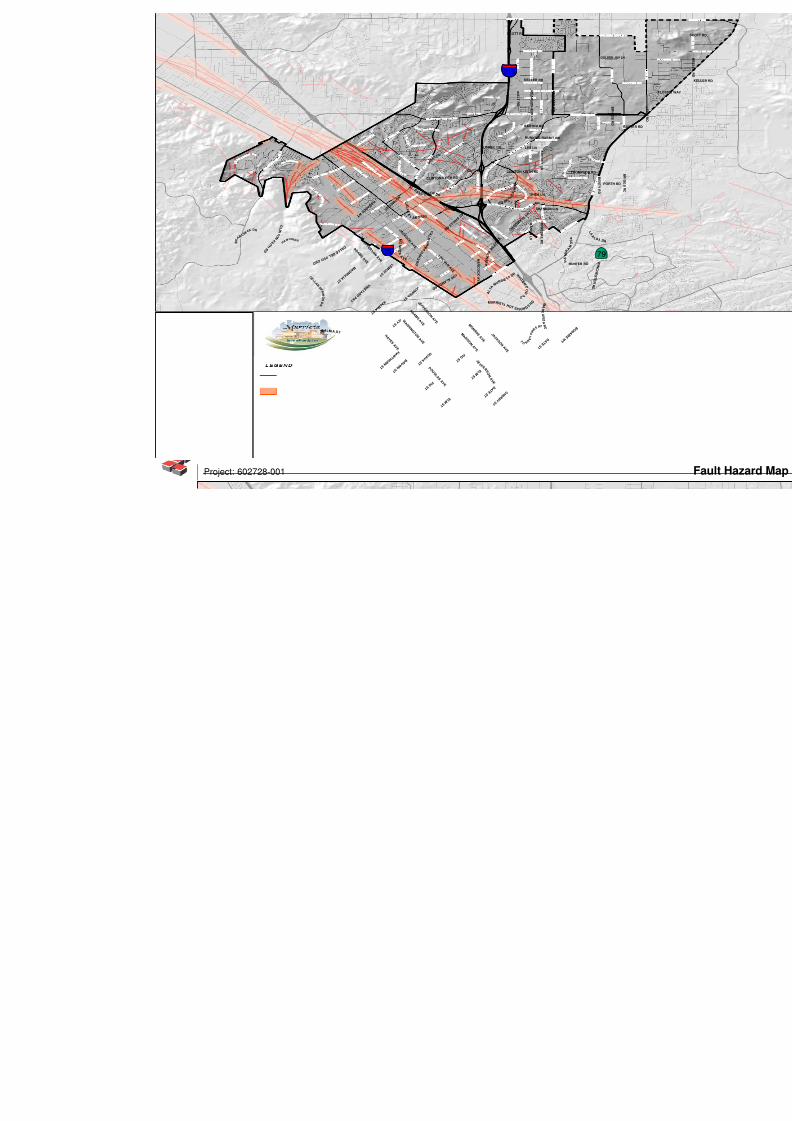
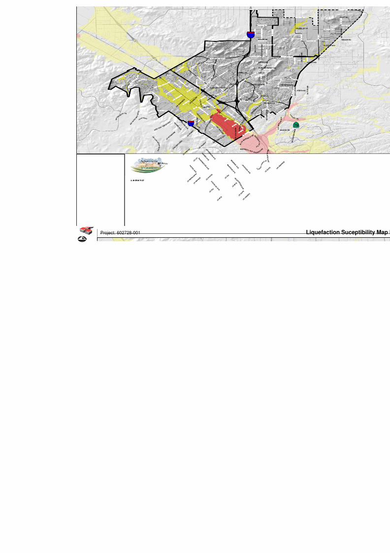
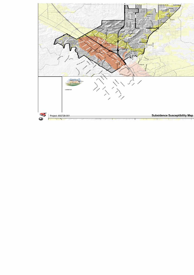
Figure 1 : Regional Geology MapFigure 2: Alquist-Priolo Earthquake Fault Zone MapFigure 3: Fault Hazard Map - Per Riverside CountyFigure 4: Liquefaction Susceptibility Map - Per Riverside County
Figure 5: Subsidence Susceptibility Hazard Map - Per Riverside CountyFigure 6: State Hazard Zones (Earthquake-Induced Landslides and Liquefac tion)
Appendices
Appendix A - References and List of Aerial Pho tographs Reviewed
Appendix B - General Grading Guidelines
8/3/2019 G_Seismic & Geologic Hazards Existing Conditions Report
http://slidepdf.com/reader/full/gseismic-geologic-hazards-existing-conditions-report 6/54
Seismic and Geologic Hazards Review 602728-001
Cifv of Murrieta, California January4 2010
1.0 I N TRODUCT I ON
1 . Purpose and Scope
The purpose of this study was to com pile and summarize the known seismic and geologic hazards
within the City of Murrieta G eneral Plan study area and provide an overview of the kn own typical
geotechnical constraints that might be expected during future land development. M ore specifically,
our scop e for this report included the following:
Establish a geo-referenced map s for the entire City,
Review in-house and published geologic reportslmaps (USGS, CGS, Riverside County,
etc.) and transfer pertinent data to the geo-referenced map s,
Review historic and current aerial photos to evaluate for past or potential geologichazards specifically for the three (3 ) specified corridors,
Provide a gene ral description of the type of native soil and rock units throughout the C ity,
Present the potential geologic hazards within the City including mapped fault traces and
Couilty and/or State of California Alquist-Priolo (AP) Earthquake Fault Zones.
Additionally, areas that are prone to liquefaction or dry seismic settlement, and other
seismic hazards such as ground rupture, rock fall hazards, landslide and subsidence are
also discussed,
Present the historic seismic activity within the City area and provide typical SeismicDesign Criteria per the current 2007 California Building Code,
Discuss the potential for encountering shallow groundwater during development of
certain areas of the City,
Discuss th e general rippability characteristics of potentially bedrock units in certain areas
of the general plan based on exiting in-house data. The report also includes general
description of previously used methods of rock excavationlreduction as well as onsite
rock disposallplacement nletl~od s,
= Discuss the potential for encountering hazardous naturally occurring minerals,
Summarize potential mass grading challenges within specific areas of the City based on
past experience, and
= Describe typical foundation types used and provide generalized geotechnical foundation
design recommendat ions for f~ ~ t u r etructures.
8/3/2019 G_Seismic & Geologic Hazards Existing Conditions Report
http://slidepdf.com/reader/full/gseismic-geologic-hazards-existing-conditions-report 7/54
Seismic and Geologic Hazards Review 602728-001
City of Murrieta/ California January 8, 2010
1.2 Citv Location and General Description
The City of M urrieta is located in southwest Riverside Co unty, north of the City of Temecula and
south of the Cities of Menifee and Wildomar. The City consists of approximately 45 square miles
of land, which has experienced significant growth in residential development since the first
General Plan in 1994. We understand that this G eneral Plan is currently being updated to address
the overall City growth and in particular, future development within three specific study areas or
corridors, which h ave the potential to attract businesses and prom ote diversified job creation for
City residents. As suc h, these three areas or corridors will be spec ifically evaluated in this report
and pertinent geotechnical constraints during future land developm ent are briefly discussed. These
corridors will be referred to in this report as Areas 1 through 3 and may be generally described as
follows:
Area 1- Southwest Murrieta / Jefferson Business Corridor: This area is currently the major
retail and light indu strial agglomeration within M urrieta and located generally west of the
Golden T riangle along the west side of Interstate 1-15, south of K almia Street and north of
the City's southern boundary.
Area 2 -Golden Trian gle: This area is gene rally located no rth of -the intersection of 1-15
and 1-2 15 and south o f Lo s Alam os R oad.
Area 3 - Northeast 1-215 and Clinton Keith Road: This is generally the northeastern
quadrant of the City located along the east side of 1-2 15 and north of Clinton Keith Road
where relatively m ost vacant land currently exists.
8/3/2019 G_Seismic & Geologic Hazards Existing Conditions Report
http://slidepdf.com/reader/full/gseismic-geologic-hazards-existing-conditions-report 8/54
Seismic and Geologic Hazards Re view 602728-001
City of Murrieta, California January8, 2010
2.0 GEOLOGY
2.1 Reqional Settinqs
The City of Murrieta (City) is located within the northern portion of the Peninsular Range
geomorphic province which is characterized by steep, elongated ranges and valleys that
generally trend northwestward from th e tip of Baja California to the Los Angeles Basin. The
City is regionally located at the base of the Santa Ana M ountains and the Santa Rosa Plateau. The
Santa Margarita and Agua T ibia ranges are approximately 12 to 14 miles to the south, and the San
Jacinto ranges lie approximately 35 miles to the east.
More specifically, the City is situated within two structural blocks or subdivisions of the
Peninsular Range province. The western foothill boundary of the City is within the Santa Ana
Mo untains block and the east portion is within the P erris block. These provinces are separated bythe active Elsinore fault zone, which forms a complex pull-apart basin (locally known as the
Murrieta-Temecula Valley) that is filled with sedimentary deposits. The relatively stable Santa
Ana Mountains and the Pel-ris Block are underlain by pre-Cretaceous aged metasedimentary
rocks and Cretaceous aged plutonic rocks of the Southern California batholith. Tertiary-aged
sedimen ts, volcanics and Quaternary-aged sediments flank the San ta Ana m ountain range to the
west, elevated portions of the valley floo r, and within the western flanks and localized valleys of
the Perris Block. The Quaternary sediments include the "Unnamed" Sandstone, Pauba
Sandston e, Pauba Fanglom erate, and younger alluvial sediments (Kenn edy, 1977).
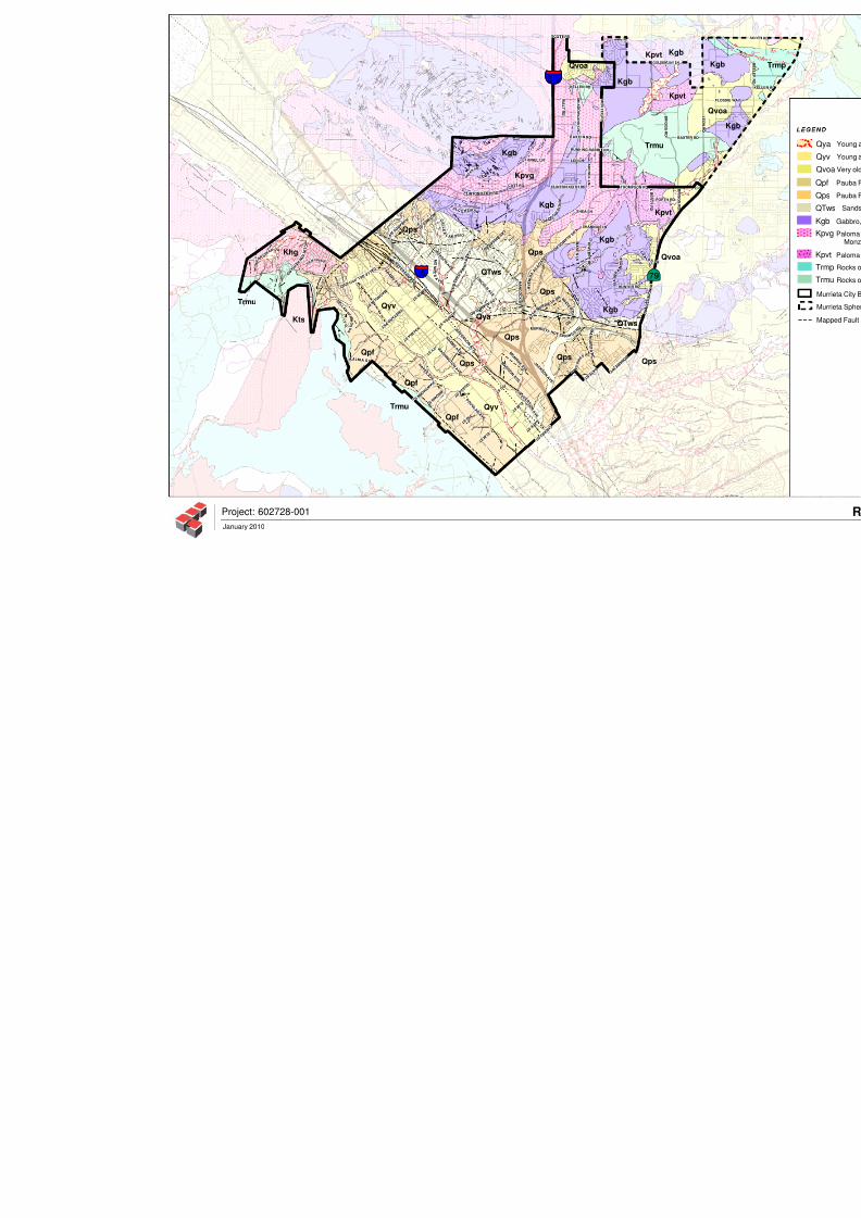
2.2 Area Geoloqy
The City is underlain by numerous surficial deposits and/or bedrock units based on published
geologic maps (Figure I ) . The major surficial deposits and bedrock units that are most likely to
be encountered during future d evelopm ents are briefly described below:
Artificial Fill (not a mapped unit): Artificial fills are generally referred to as
undocumented fills or engineered (documented) fills. Undocumented fills are typically
those fills that were placed without the review and testing of a geotechnical consultant.
Engineered fills are those fills that were observed and tested by a geotechnical consultant.
Most artificial fills within the City are expected to be engineered and placed duringconstructioil of existing public roads and private developments. The engineering
characteristics and vertical or horizontal extent of these fills are site-specific.
Colluvial Deposits (not a m apped unit): Colluvium is the name for sediments that have
been deposited or built up at the bottom of a low-grade slope or against a barrier on that
8/3/2019 G_Seismic & Geologic Hazards Existing Conditions Report
http://slidepdf.com/reader/full/gseismic-geologic-hazards-existing-conditions-report 9/54
Seismic and Geologic HazardsReview 602728-001
City of Murrieta, Cabfornia January 8, 2010
slope, transported by gravity. These deposits generally consist of silty sand and sandy
gravel with abundant angular and sub-angular fragments of the underlying bedrock units.
Young Axial-Channel Deposits (map symbol Qya): These alluvial deposits (late
Holocen e) are generally foun d in active stream beds, flood plains or channels and consistof unconsolidated to locally poorly consolidated sand and gravel with small amounts of
silt.
Young Alluvial-Valley Deposits (map symbol Qyv): These alluvial flood plain
deposits (Pleistocene, younger than 500,000 years) are generally found along the main
Murrieta Creek channel and expected to exceed 100 feet in depth. These deposits cover
positions of Area 1.
Very Old Alluvial Channel Deposits (map sym bol Qvoa): These alluvial deposits are
generally deposited on canyon floors and consist of moderately to well-indurated,
reddish-brown mostly dissected gravel, sand, silt and clay. These deposits are generally
found in the northeastern portion of the City.
Pauba-fanglomerate (map symbol Qpf): The Pauba-fanglomerate member (Pleistocene)
is well indurated, poorly sorted fanglomerate and mudstone and generally found along the
east flank of the Santa Ana M ountains (west of the City).
Pauba-sandstone (map symbol Qps): The Pauba-sandstone formation (Pleistocene) is
poorly to moderately well-indurated, extensively crossbedded, channeled and filled
sandstone and siltstone that contains local intervening cobble-and-boulder conglomerate
beds. T his formation is generally found in the southern half of the City including most of
Area 2 and portions of Area 1.
Sandstone and Conglomerate of Wildom ar area (map symbol QTws) ): This formation
consist primarily of friable, pale yellowish-green, medium grained, caliche-rich sandstone
and located in m iddle portion of the C ity, just north of the Golden T riangle Area.
Basalt of the Hogbacks (not mapped): The locally named Hogbacks are an elevated
hilltop located in the eastern portion of the City. Capping this unique feature is a remnant
channel filled with basalt (Tertiary-age).
Gabbro (map symbol Kgb): This Cretaceous-age granitic formation also constitutes
portions of the hills along the northern part of the City and underlies the older alluvium in
Area 3 (Northeast 1-215 and Clinton Keith Road).
Monzogranite to Granodiorite (map symbol Kpvg): This Cretaceous-age granitic
formation locally known as the Paloma Valley Ring Complex constitutes portion of the
hills along the northern part of the City and underlies the older alluvium in Area 3
(Northeast 1-215 and Clinton Keith Road).
8/3/2019 G_Seismic & Geologic Hazards Existing Conditions Report
http://slidepdf.com/reader/full/gseismic-geologic-hazards-existing-conditions-report 10/54
Seismic and Geologic Hazards Review 602728-001
City of Murrieta, California January 8, 2010
To na lite (m ap sym bol Kpvt): This Cretaceous-age granitic formation locally known as
the Paloma Valley Ring C omplex is found along the northeastern part of the City.
Metasedim entary Rock (ma p symbol Trm pITr mu ): This Mesozoic-aged
metamorphic grade marine sedimentary rock unit, locally known as the Bedford CanyonFormation, exists in the northeastern quadrant of the City. This bedrock unit consists of
locally folded, laminated to thinly bedded argillite, slate, shale and impu re quartzite.
2.3 Site-Specific Geoloqv (Areas 1 hrouqh 31
Based on past experience and review of the referenced reports (Appendix A), the engineering
and geolog ic characteristics of the soils and/or bedrock units w ithin Areas 1 through 3 are further
described and summ arized as follows:
Area 1 - Southw est Musrieta I Jefferson B usiness Corridor:
Area 1 is generally underlain by Pauba formation (sandstone-member, Qps) and young alluvial-
valley deposits (Qyv) see Geologic Map - Figure I . According to previous site specific reports
performed within this area, the following geologic conditions and geotechnical concerns can be
summarized:
The Pauba formation generally consists of brown to light brown, clayey, fine-grained
siltstones and siltylclayey, fine- to coarse-grained sandstones (Leighton, 2004 & 2008a,
and CHJ, 2007). The Pauba formation in this area is generally considered suitable for
support of structures and for use as engineered fill. These soils generally have low
Expansion Index (EI<51). However, expansive clay and silt layers may be locallyencountered.
The alluvial-valley deposits are mostly moderately well consolidated, poorly sorted,
permeable flood plain deposits consisting of silty sand (SM), poorly-graded to well-
graded sand (SPISW), clayey sand (SC), and sandy clay (CL). Published geologic maps
and previous site specific field explorations within this area indicate that the alluvium
may exceed 100 feet in depth . The alluvial soils may be susceptible to liquefaction and/or
subsidence. The alluvial soils are generally considered suitable for support of structures
and for use as engineered fill. These soils generally have low Expansion Index ( E I 4 1 ) .
How ever, expansive clay and silt layers may be locally encountered.
Area 2 - Golden Triangle:
The majority of Area 2 is underlain by the Pauba-sandstone formation (Qps) and conglomerate
unit of the Wildomar area (QTws) and localized alluvial-channel deposits (Qya), see Geologic
Map - Figure I . According to previous site-specific reports performed within this area, the
following geologic/geotechnical conditions can be summ arized:
8/3/2019 G_Seismic & Geologic Hazards Existing Conditions Report
http://slidepdf.com/reader/full/gseismic-geologic-hazards-existing-conditions-report 11/54
Seismic and Geologic Hazards Review 602728-001
Cify of Murrieta, California January 8, 2010
The Paub a form ation consists of brown to light brown, clayey, fine-grained siltstones and
siltylclayey, fine- to coarse-grained sandstones (Leighton, 2004 & 2007). The Pauba
formation in this area is generally considered suitable for support of structures and for use
as engineered fill. These soils generally have low expansion potential (EI<5 1). However,
expansive clay and silt layers may b e locally enc ountered.
The alluvial-channel deposits consist of unconsolidated to locally poorly consolidated
sand and gravel with small amounts of silt. The alluvial soils may be susceptible to
liquefaction and lor subsidence and generally not suitable for support of settlement-sensitive
structures in their natural state.
Area 3 - Northeast 1-215 and C linton Keith R oad:
This northeast development area (Area 3) is primarily underlain by granitic and metamorphic
bedrock, see Geologic Map - Figure I . According to previous site-specific reports performed
within this area, the followin g geologic1 geotechnical conditions can be su mm arized:
The majority of A rea 3 is underlain by Cretaceous-aged granitic bedrock which varies in
com position from Monzogranite to Granodiorite (Kpvg) to that of Gabbro (Kgb). The
granitic bedrock is locally overlain by a thin veneer of older alluvium (Qvoa). Younger
alluvial deposits may a lso be present locally infilling som e surface drainages.
Based on previous reports in this area (Leighton, 2006 and Kleinfelder, 2007), the
condition of the near surface bedrock varies from that of highly disintegrated rock that
has weathered becoming soil-like deposits (saprolite) to that of relatively unweathered,
hard, very dense, igneous rock. W here exposed, the granitic rocks of n~ onzo gran ite nd
granodiorite comp osition are generally light gray to gray to grayish brown. Th e gabbroicbedrock ob served in this area is generally gray to dark gray.
Th e granitic bedroc k is generally considered suitable for suppo rt of structures and use for
engineered fill.
2.4 Groundwater
Based on a review of the referenced reports, groundwater has been encountered less than 10 feet
below the existing ground surface along Murrieta Creek. Depth to subsurface water has been
reported by the State of California (California Department of Water Resources, 2009) at depths
ranging from 21 feet to lOOf feet below ground surface (bgs) in the overall area. However,
depending on rainfall and seasonal variation, shallower perched water conditions may exist and
typically accumulate within layers of differing permeability, within bedrock fractures and at
bedrocklfill con tacts. In additio n, groundw ater seepage can occur in deep cuts in the hills along the
northern side of the City as reported during grading of the existing Greer Ranch Residential
8/3/2019 G_Seismic & Geologic Hazards Existing Conditions Report
http://slidepdf.com/reader/full/gseismic-geologic-hazards-existing-conditions-report 12/54
Seismic and Geologic Hazards Re view 602728-001
City of Murrieta, California January8,2010
development (Leighton, 19 99 & 2003). S uch condition s are typically mitigated by the placement o f
subdrains and other appropriate long-term dew atering measures at the time of construction or when
the seepage is observed.
2.5 Geoloqic Hazards
This section discusses the non-earthquake related geologic hazards within the City. The
earthquak e- or seismically-induced h azards are discussed in Section 3 of this report.
The potential extent and severity of any non-earthquake related geologic hazard varies
throughout the General Plan area depending upon the underlying geology, topography, surface
soil type, and groundwater conditions. The most common geologic hazards that may be
encountered are as follows:
2.5.1 Expansive Soils
Expansive soils are surface deposits rich in clays that expand when wet and shrink when
dried. This change in volume can exert detrimental stresses on buildings and cause
structural damage. Expansive soils can be widely dispersed and can be found in hillside
areas as well as low-lying alluvial basins. There have been reported cases (Leighton, 2004,
2008a) of expan sive clay layers within the Pauba form ation and Alluvial-Valley deposits.
The site-specific geotechnical reports typically identify the extent of the expansive soils
and provide mitigation measures to reduce their impact on the proposed improvements.
Such measures may include structural mitigation or ground improvement. The CaliforniaBuilding Code contain s minim um requirements for construction on expansive soils.
2.5.2 Collapse Soils
The collapse soils phenomenon or "Hydro-consolidation" typically occurs in recently
deposited soils (Holocene age - less than 10,000 years old) that were deposited in an arid
or semi-arid environment. These soils typically contain a high percentage of voids and
posses s low relative density. The soil particles may be partially supported by clay or silt,
or chemically cemented with carbonates. When inundated by water, these soils collapse
and substantial settlement o ccurs.
Dam age to structures and ground cracking due to hydro-consolidation (collapse) of recent
alluvial deposits has occurred in the "California Oaks" area of Murrieta (Pacific Soils,
1992). Documented collapsible s oils in the Cal Oak s area were determined to be the most
severe and resulted in significant property damage. It wa s discovered that the alluvium
was left in place during rough grading, and later collapsed when g round water levels rose
significantly due to irrigation or rise in groundwater.
8/3/2019 G_Seismic & Geologic Hazards Existing Conditions Report
http://slidepdf.com/reader/full/gseismic-geologic-hazards-existing-conditions-report 13/54
Seismic and Geologic Hazards Review 602728-001
City of Murrieta, California January 8, 2010
The site-specific geotechnical reports should identify the potential presence of such soils
based o n laboratory testing and provide mitigation measures to reduce their impact on the
proposed improvements. Such measures typically include removing and compacting the
collapsible soils.
2.5.3 Loadinq Settlement
Settlement due to loading can be immediate or occur gradually over a long period of
time. Immediate settlement is normally associated with loose granular soils when
subjected to loads. Long-term or "consolidation" settlement normally takes place in soft
saturated silts and clays. These types of soils are generally found in young alluvium or
loosely deposited m aterials.
Similar to Collapse Soils above, the site-specific geotechnical reports typically identify
the potential presence of these materials based on laboratory testing and providemitigation measures to reduce their impact on the proposed improvements. Such
measures typically include removing and compacting the loose or soft soils, surcharging
the planned development area or structural mitigation. Structural mitigation may include
deep foundation such as piles embedded into underlying dens e formation.
2.5.4 Subsidence
Subsidence is the ground settlement that results over time from the extraction of
groundwater or oil. This is a phenomenon that usually extends over a large area and
occurs on a gradual basis so the settlement effects on a single site, relative to its
imm ediate neighbors, may be negligible as the neighboring properties are also subsiding.However, ground fissuring due to subsidence can cause structural damage and should be
evaluated by the site-specific geotechnical report. Although there are no reports of
significant subsidence due to groundwater withdrawal in Murrieta, alluvial valley areas
are considered susceptible (see Figure 5).
2.5.5 Hazardous Minerals / Radon
Naturally occurring geologic formations through out California may contain minerals that
are considered hazardous. Th ese minerals are Asbestos, Mercury and rocks that contain
sma ll amounts of uranium and th orium that decay and release radioactive radon gas.
Radon gas is a naturally occurring radioactive g as that is invisible, tasteless and odorless.
Radon gas becomes hazardous when confined in buildings and the long term exposure
levels in the air exceed the United States Environmental Protection Agency's (EPA)
concentration of 4 picocuries per liter (4pC i/L).
8/3/2019 G_Seismic & Geologic Hazards Existing Conditions Report
http://slidepdf.com/reader/full/gseismic-geologic-hazards-existing-conditions-report 14/54
Seismic and Geologic Hazards Review 602728-001
Cify of Murrieta, California January 8, 2010
Rocks containing minerals that are known to release radon gas exist in the Murrieta area
(CGS, 2009). Mo re information on the risks associated with radon, information on testing
and remediation methods can be found at the California Department of Public Health
Services website: http://www.cdph.ca.gov/HealthInfo/environhealth/Pages/Radon.
8/3/2019 G_Seismic & Geologic Hazards Existing Conditions Report
http://slidepdf.com/reader/full/gseismic-geologic-hazards-existing-conditions-report 15/54
Seismic and Geologic Hazards Review 602728-001
Ci?y of Murrieta, California January 8, 201
3.0 S E I S M I C I T Y A N D F A U L T I N G
3.1 General
Murrieta, like the rest of Southern California, is located within a seismically active region as a
result of being located near the active margin between the IVorth Am erican and Pacific tectonic
plates. Based on published d ata (Blake 2002), the m ost significant known active Fault Zones that
are capable of seismic ground shaking and can im pact the City include:
Elsinore Fuz~lt one: This fault zone, which includes the local Elsinore-Temecula fault,
passes through the City to the west of Interstate 1-15 (Figures 2 and 3). The Elsinore-
Temecula fault zone is capable of generating a Maximum Earthquake M agnitude (M w)
of 6.8 per the Richter scale.
Sun Jucinto Fault Zone: This fault zone is located approximately 21 miles northeast ofthe City and capable of generating earthquakes in excess of 7.1 Mw .
Newport-Inglewood Fault Zone (offshore): This fault zone is located about 28 miles
southwest of the City and capable of generating earthquakes in excess of 6.9 Mw.
Sun Andreas Fuztlt Zone (southern section): This fault zone, located approximately 38
miles northeast of the City, is considered the dominant active fault in California. This
fault zone is capable of generating earthquakes in excess of 7.4 Mw .
The Alquist-Priolo Hazards Act (A-P Act) passed by the State legislature in 1972 (renamed the
Alquist-Priolo Earthquak e Fault Zoning Act in 1994) established earthquake fault zones along
faults considered by the State Division of Mines and Geology to be active or potentially active.
An active fault is considered one which has experienced surface displacement within the last
11,000 years, while a potentially active fault is a fault which has m oved during the past 1.6
million years but proven to have not m oved within the past 11,000 years. Such displacement can
be recognized by the existence of cliffs in alluvium, terraces, offset stream courses, the
alignment of depressions, sag ponds, fault troughs and saddles, and the existence of markedly
linear steep mountain fronts. However, some active faults are not visible at the surface and can
only be located throug h detailed subsu rface investigations.
The State Geologist designates seismic hazard zones and the State issues earthquake fault zone
maps to assist cities and counties in avoiding the hazard of surface fault rupture. The State has
identified two Alquist-Priolo Earthquak e Fault zones within the City. The Tem ecula Segm ent of
the Elsinore Fault Zone trav erses -the City and the M urrieta Creek F ault is located at the extrem e
southwest corner of the City (See Figure 2 - Alquist-Priolo Earthquake Fault Zone Map). The
8/3/2019 G_Seismic & Geologic Hazards Existing Conditions Report
http://slidepdf.com/reader/full/gseismic-geologic-hazards-existing-conditions-report 16/54
Seismic and Geologic Hazards Review 602728-001
City of Murrieta, California January8, 201
earthquak e fault zones extend about 500 feet in width on either side of a major active fault trace
and about 200 to 300 feet in width on either side of a well defined minor active fault, as
designated by the State. Development of a building for human occupancy is generally restricted
within 50 feet of an identified fault (Riverside, 2003).
In addition to the State A-P Act mapping, the County of Riverside has zoned fault systems and
required similar special studies prior to land development. These are referred to as Riverside
County Earthquake Fault Zones (Figure 3).
3.2 Fault Rupture
Faults throughout southern California have formed over millions of years. Some of these faults
are generally considered inactive under the present geologic conditions. As indicated above,
several State and County Faults systems are mapped within the City boundaries and any
propose d tracts of four or more dwelling units or critical structures such as hospitals, schools or
emergency structures must investigate the potential for and setback from ground rupture hazards
(Riverside County, 2003). This is typically accomplished by excavation of a trench across the
site, determining the location of faulting, and establishing building setbacks. Methods for the
evaluation of s ite ground rupture are f ~ ~ r t h e rresented in the California Geologic Survey Note 49
(CGS, 2002).
In accordance with The Alquist-Priolo Earthquake Fault Zone Act, before a pro-ject can be
permitted within a fault zone, a geologic investigation m ust demonstrate that proposed buildingswill not be constructed across an A-P or County Fault Zones. A site-specific evaluation and
written report must be prepared by a California licensed geologist. If an active fault is found, a
structure for human occupancy must be setback 50 feet froin the fault unless adequate evidence
is presented to support a different setback (Riverside, 2003).
3.3 Ground Shaking
The intensity of earthquake ground shaking varies from one area to another depending primarily
upo n the distance to the fault, the magnitud e of the earthquake, and the local geology. The effect
of seismic shaking on future structures or land development projects within the City may bemitigated by adhering to the 2007 California Building Code (CBC) or applicable codes and
standards at the time. Site-specific peak and spectral accelerations are to be developed in
accordance with Chapter 21 of the 2007 CBC, and the guidelines included in American Society
of Civil Engineers Standard 7-05 (ASCE, 2005). For the purpose of illustration, typical seismic
design values per the 2007 CBC, Chapter 16, for study Areas 1 through 3 are provided below.
8/3/2019 G_Seismic & Geologic Hazards Existing Conditions Report
http://slidepdf.com/reader/full/gseismic-geologic-hazards-existing-conditions-report 17/54
Seismic and Geologic Hazards Review 602728-001
City of Murrieta, California Januaty 8, 2010
The CBC regulates the design and construction of excavations, foundations, building frames,
retaining walls, and other building elements to mitigate the effects of seismic shaking and
adverse soil conditions. The procedures and limitations fo r the design of structures are based on
site characteristics, occupancy type, con figuration, structural system, height, and seismic zoning.
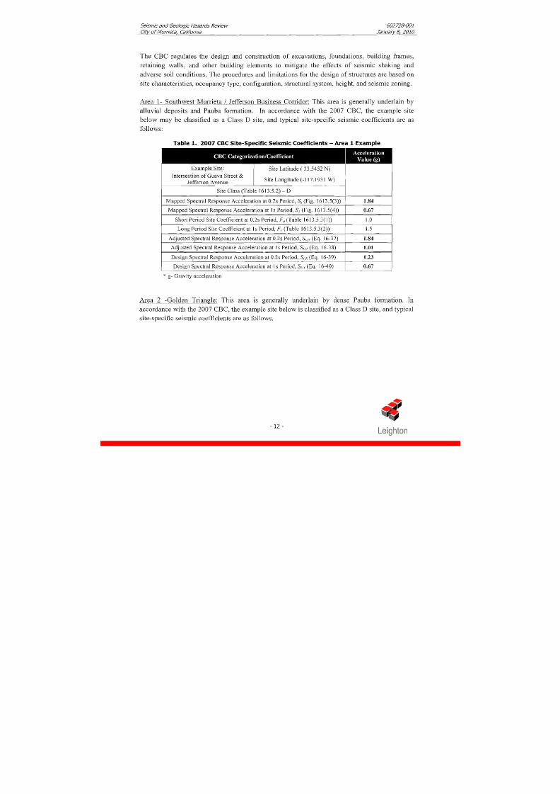
Area 1- Southwest Murrieta / Jefferson Business Corridor: This area is generally underlain by
alluvial deposits and Pauba formation. In accordance with the 2007 CBC, the e xa~ np le i te
below may be classified as a Class D site, and typical site-specific seismic coefficients are as
follows:
Table 1. 2007 CBC Site-Specific Seismic Coefficients- Area 1Example
1Example Site:
1Site Latitude ( 33.5452 N )
1 1Site Class (Table 1613.5.2) - D
Mapped Spectral Response Acceleration at 0.2s Period, S , (Fig. 16 13 4 3 ))
Mapped Spectral Response Acceleration at 1 s Period, S t (Fig. 16 13.5(4 ))
Short Period S ite Coefficient at 0.2s Period, F,,(Table 1613.5.3( 1))
Intersection of Guava S treet &Jefferson Avenue
I Long Period Site coe ffici enta t 1s Period, F,. Table 1613.5.3(2)) / 1.5 I
Site Longitude (-1 17.1931 W )
- - - - - -Design Spectral Response Acceleration at 0.2s Period, St,,(.Eq. 16-39)Design Spectral Response Acceleration at Is Period, St , , (Eq. 16-40)
Adjusted Spectral Respo nse Acceleration at 0.2s Period, S,,,,,c Eq. 16-37)
Adjusted Spectral Response Acceleration at I s Period, S,,,, (Eq. 16-38)
* g- Gravity acceleration
1.84
1.01
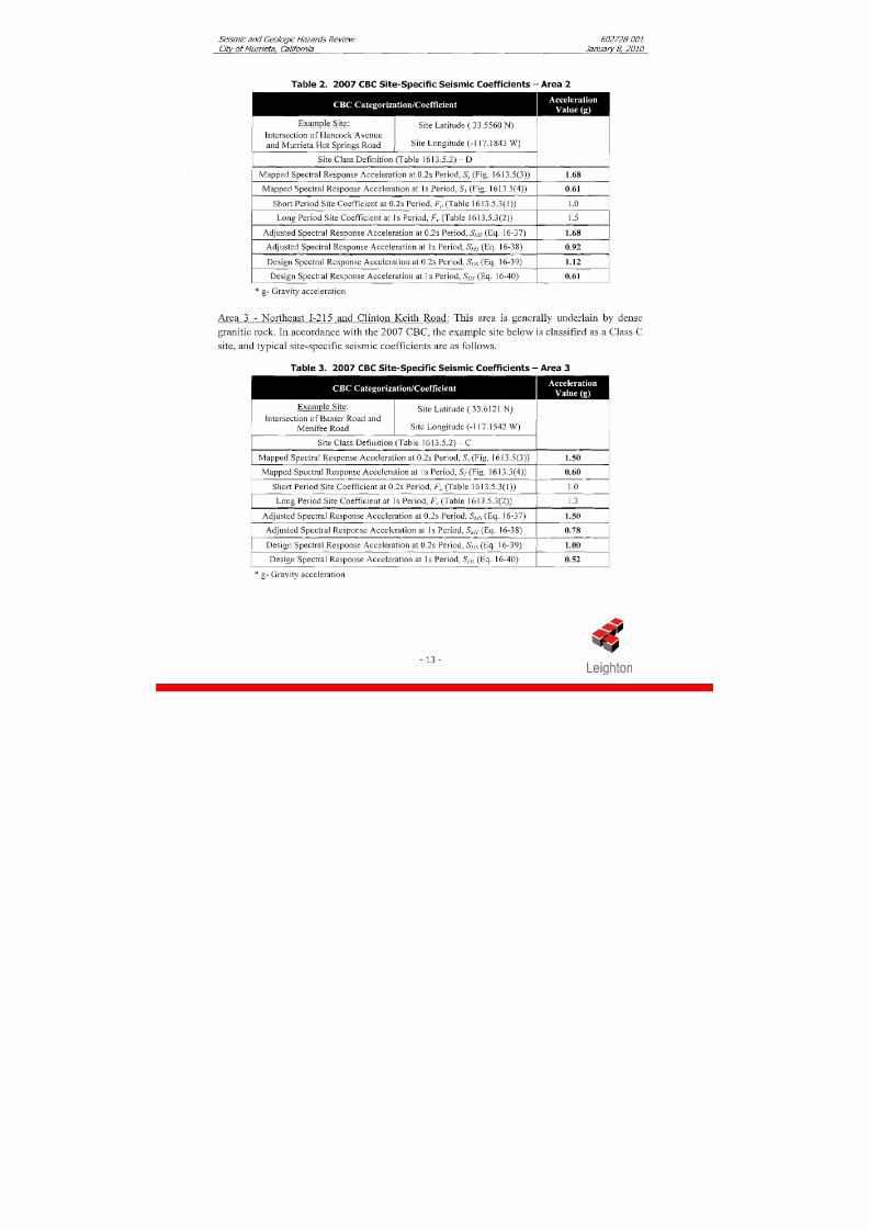
Area 2 -Golden Triangle: This area is generally underlain by dense Pauba formation. In
accordanc e with the 2007 C BC, the example site below is classified as a Class D site, and typical
site-specific seisillic coefficients are as follows.
8/3/2019 G_Seismic & Geologic Hazards Existing Conditions Report
http://slidepdf.com/reader/full/gseismic-geologic-hazards-existing-conditions-report 18/54
Seismic and Geologic Hazards Review 602728-001
City of Murrieta, California January 8, 201
Table 2. 2007 CBC Site-Specific Seismic Coefficients- Area 2
Short Period Site Coefficient at 0.2s Period, F,, (Table 1613.5.3(1))
Lon g Period S ite Coefficient at 1s Period, F, , (Table 1613.5.3(2))
~ x a r n ~ l eite: Site Latitude ( 33.5560 N)
Intersection of H ancock A venueand Murrieta Hot Springs Road Site Longitude (- 1 17.1843 W)
- -I ~ d j u s i dpectralkesponse Acceleration aF0.2s Period, Sh1.y (E q 16-37) 1 1.68 1
Site Class Definition (Table 1613.5.2) -D
Mapped Spectral Response Acceleration at 0.2s Period, 5, (Fig. 1613.5(3))
Mapped Spectral Response Acceleration at 1s Period, S , ( Fig. 16 13 34 ) )
1.68
0.61
Adjusted Spectral Response Acceleration at Is Period, Sn4,Eq. 16-38)
Design Spectral Response Acceleration at 0.2s Period, Sl,,s (Eq. 16-39)
Area 3 - Northeast 1-215 and Clinton Keith Road: This area is generally underlain by dense
granitic rock. In accordan ce with the 2007 CBC, the exam ple site below is classified as a Class C
0.92
1.12
Design Spectral Response Acceleration at Is Period, SDl (Eq. 16-40)
site, and typical site-specific seismic coefficients are as follows.
0.61
Table 3. 2007 CBC Site-Specific Seismic Coefficients - Area 3
* g- Gravity acceleration
Exam ple Site: Site Latitude ( 33.6 12 1 N) 1Intersection of Baxter Road and
Menifee Road Site Longitu de (-1 17.1542 W )
Site Class Definition (T able 1613.5.2)- C
Mapped Spectral Response Acceleration at 0.2s Period, S , (Fig. 16 13.5(3))
Mapped Spectral Response Acceleration at Is Period, Sl (Fig. 16 13.5(4))
Short Period S ite Coefficient at 0.2s Period, F,, (Table 1613.5.3(1))
1.50
0.60
I .OLong Period Site Coefficient at Is Period, F , Tab le 16 13.5.3(2))
Adjusted Spectral Response Acceleration at 0.2s Period, S,,,l,yEq. 16-37)
Adjusted Spectral Response Acceleration at Is Period, SM l Eq. 16-38)
* g- Gravity acceleration
1.3
1.50
Design Spectral Response Acceleration at 0.2s Period, Sl Is Eq. 16-39)
Design Spectral Response Acceleration at Is Period, S,, , (Eq. 16-40)
1OO
0.52
8/3/2019 G_Seismic & Geologic Hazards Existing Conditions Report
http://slidepdf.com/reader/full/gseismic-geologic-hazards-existing-conditions-report 19/54
Seismic and Geologic Hazards Review
City of Murrieta, California
602728-001
January S, 201
3.4 Secondarv Seismic Hazards
Ground shak ing can induce "secondary" seismic haza rds such as liquefaction and/or lateral
spreading, landslides, and subside nce and ground fissuring. Areas of the City know n to be at risk
from these hazards have been mapped and shown on Figures 4, 5 an d 6 (Liquefaction and
Subsidence Susceptibility Maps and Seismic Hazard Map, respectfully).
3.4.1 Dvnamic Settlement / Liauefaction and "Drv" Settlement
Liquefaction of saturated cohesionless soils can be caused by strong ground motion
resulting from earthquak es. Soil liquefaction is a phenom enon in which saturated,
cohesionless soils lose their strength due to the build-up of excess pore water pressure
during cyclic loading such as that induced by earthquakes. The primary factors affecting
the liquefaction potential of deposit are: 1) intensity and duration of earthquake shaking,
2) soil type and relative density, 3) overburden pressures, and 4) depth to groundwater.
Soils most susceptible to liquefaction are clean, loose, uniformly graded, fine-grained
sands, and non-plastic silts that are saturated. Silty sands, under certain site conditions,
may also be susceptible to liquefaction. As depicted on Figure 4, most of the alluvial
deposits along the Murrieta Creek lie within liquefaction hazard zone per County of
Riverside. Most of these alluvial soils are also considered susceptible to liquefaction per
State Seismic Hazard Zones (Figure 6) . Future development within these areas, require a
site-specific evaluation for liquefaction hazard .
In addition to liquefaction settlement, dynam ic densification of "dry" or moist soil above
the water table can occur. The site-specific evaluation for future developm ent should
also include evaluation for settlement associated with dynamic densification of "dry"
soils. To reduce the effects and magnitude of seismically-induced dynamic settlements,
remedial grading measures or ground improvement techniques are normally
implemented.
3.4.2 Lateral S~readinq
The phenomenon of liquefaction may also produce lateral spreading of soils adjacent to a
body of water or water course (Mussieta Creek and Warm Springs Creek). Lateral
spreading is therefore considered as a liquefaction-induced ground failure whereby
block(s) of surficial intact natural or artificial fill soils displace laterally downslope or
towards a free face along a shear zone that has formed within the liquefied sediment
(Bastlett and Youd, 1995). The displacement of the ground surface associated with thislateral spreading may be on the order of several inches to several feet at the top of the
slope and may affect areas well beyond the top-of-slope. Developments located further
from the creeks or drainage courses are anticipated to be at less risk from lateral
spreading that those adjacent to the creek embankment. Detailed analyses of lateral
spreading affects to properties adjacent to creeks and drainages should be performed by
8/3/2019 G_Seismic & Geologic Hazards Existing Conditions Report
http://slidepdf.com/reader/full/gseismic-geologic-hazards-existing-conditions-report 20/54
Seismic and Geologic Hazards Review 602728-001
City of Murrieta, California January8, 2010
the geotechnical consultant on a site-by-site basis. To reduce the effects or magn itude of
lateral spreading, remedial grading measures on ground improvement techniques are
normally implemented.
3.4.3 Differential Subsidence and Ground Fissurinq
Ground fissuring typically develops along previous established planes of weakness such
as active and possibly potentially active fault traces as well as alon g steep buried contacts
between bedrock to recent alluvial soils. The active Elsinore-Temecula and the Murrieta
Creek fault may develop fissuring along the fault trace during a significant seism ic event
or groundwater elevation change. As such, there is a low to high potential for ground
fissuring and associated differential subsidence along the active fault zones. If
commercial water w ells are installed within or near the su bsidence zone, the potential for
ground fissuring and differential settlement could be substantially increased.
3.4.4 Seiches and Tsunamis
A seiche is an oscillation of a landlocked body of water that can cause water damage to
buildings, roads, and infrastructure that surround the body of water. Due to the distance
to existing large bodies of water (i.e. Diam ond V alley Lake, Lak e Skinner, Lake Elsinore,
etc.), it is expected that such hazard should not be a concern for structures within the
City.
A tsunami is a great ocean wave produced by submarine earth movement or volcanic
eruption. The C ity is more than 2 0 miles from the P acific Ocean. Therefore, the potential
for tsunamis is nonexistent.
3.4.5 Floodinq
Portions of the City lie within the boundaries of the FEMA 100-year flood plain.
Potential flood hazard should be evaluated on a case-by-case basis during individual site
developments. Flooding could also occur along the Warm Springs Creek due to potential
breach of any of dams associated with Diamond Valley Lake and Lake Skinner. This
report does not address such flood hazard risk.
3.4.6 Landslides
The potential for earthqu ake related landsliding within the City limits is based on known
conditions and published geologic maps. Several Old landslides have been mapped insome areas along the S anta Ana Mou ntains eastern slopes and the hills along the northern
side of the City. The State Seismic Hazard Zones (CGS, 2007) provides locations of
previous known landsliding or where local conditions indicate a potential for ground
displacements (see Figure 6). Site-specific geologic review should be performed to
8/3/2019 G_Seismic & Geologic Hazards Existing Conditions Report
http://slidepdf.com/reader/full/gseismic-geologic-hazards-existing-conditions-report 21/54
Seismic and Geologic Hazards Review 602728-001
Cily of Murrieta, California January8, 2010
determine whether the potential for landsliding or slope instability exists and whether
buttressing or other slope stabilization methods or avoidance are required.
3.4.7 Rock Fall Hazards
The potential for rock fall due to natural weathering and instability or rock falls due to a
seismic event are possible in local areas of the C ity. The hazard areas a re limited to those
properties at the base of hill sides where rocks and boulders exist. Site-specific geologic
review should be performed to evaluate such hazard and provide appropriate corrective
measures. To reduce the potential effects from rock falls in these areas, mitigation may
include avoidance, rock rem oval, anchoring or catchment devises.
8/3/2019 G_Seismic & Geologic Hazards Existing Conditions Report
http://slidepdf.com/reader/full/gseismic-geologic-hazards-existing-conditions-report 22/54
Seismic and Geologic Hazards Review 602728-001
City of Murrieta, California January 8, 201
4.0 G R A D I N G A N D D E S I G N C O N S I D E R A TI O N S
4.1 General
Future land development within the City should be evaluated on a site-specific (or individual
project) basis to address the potential hazards outlined in this report. The following sections
discuss typical grading concerns and provide general criteria for earthwork construction based on
past exp erience in the City and in accordan ce with c urrent standard of care in this locality.
4.2 Gradinq and Earthwork Considerations
Grading and earthwork construction for future land developm ent within the City should conform
to the latest edition of the CBC and City andlor County grading ordinances. The General
Earthwork and Grading Specifications presented in this report (Appendix B) are provided fortypical grading projects in this locality and may be used for future developments provided they
are reviewed and found applicable by the geotechnical consultant of the specific development(s).
4.2.1 Site Preparation
Prior to any site grading, the contractor should clear any surface and subsurface
obstructions, including debris, abandoned improvem ents and heavy vegetation. Holes
resulting from removal of buried obstructions, which extend below the depth of removal
based on site-specific study, should be filled with properly compacted soil. Existing
wells, septic tanks and associated utilities should be abandoned and cleared in accordance
with City and County guidelines.
4.2.2 Remedial Gradinq
Remedial grading requirements fo r any given site are determined based on a site-specific
geotechnical investigation to provide stable ground for the proposed development or
structures. Generally, the upper weathered formational materials or loose soils are
removed until dense, relatively "non-com pressible" soils (alluvium or Formation
materials) are encountered. This remedial removal will typically reduce the adverse
impact of the static or dynamic settlements on settlement-sensitive structures. Based on
past experience and review of the references included in Appendix A, the following
remedial grading should be anticipated within the following specific three areas:
Area 1 Southwest M urrieta 1Jefferson Business Corridor:
This area is generally underlain by Pauba formation (sandstone-member) and young
alluvial-valley and -channel depo sits as well as undoc umen ted fill soils. For planning
8/3/2019 G_Seismic & Geologic Hazards Existing Conditions Report
http://slidepdf.com/reader/full/gseismic-geologic-hazards-existing-conditions-report 23/54
Seismic and Geologic Hazards Review 602728-001
City of Murrieta, California January 8,201
purposes, the following general remedial grading should be anticipated beneath
settlement-sensitive structures including slopes and pavemen t:
Undocz~mentedfill: ypically all removed and recompacted provided these soils are
suitable for reuse a s engineer ed fill.
Alluvial-channel deposits: typically all removed and recompacted provided depth
is less than 10 to 20 feet. Deeper alluvium in some locations may be left in place
provided it is found suitable by the geotechnical c onsultant.
Alluvial-valley deposits: typically the upper 5 to 10 feet are removed and
recompac ted. De eper alluvium is generally left in place provided it is found
suitable by the geotechnical c onsultan t and/or improved in place.
P au ba Jornzation: typically the upper 2 to 5 feet are removed and recompacted.
Deeper soil is generally left in place provided it is found suitable by the
geotechnical consu ltant against collap se potential or slope instability.
Area 2 -Golden Triangle:
This area is generally underlain by Pauba formation (sandstone-member) and young-
channel deposits as well as potential undocumented fill soils. In general, the following
remedial grading should be anticipated beneath settlement-sensitive structures including
slopes and pavement:
Undocumented.fil1: typically all removed and recompacted provided these soils are
suitable for reuse as enginee red fill.
Allzivial-channel deposits: typically all removed and recompacted provided depthis less than 10 to 20 feet. Deeper alluvium in some locations may be left in place
provided it is found suitable by the geotechnical consultant.
Pazlba ,formation: typically the upper 2 to 5 feet are removed and recompacted.
Deeper soil is generally left in place provided it is found suitable by the
geotechnical c onsulta nt against collapse potential or slope instability.
Area 3 - Northeast 1-215 and Clinton Keith Road:
Th is area is generally underlain by granitic bedrock covered with a relatively thin veneer
of older and/or younger alluvial deposits. In general, the following remedial grading
should be anticipated beneath settlement-sensitive structures including slopes andpavement:
Undocumented.fil1: If encountered, all removed and recompacted provided suitable
for reuse as engine ered fill.
8/3/2019 G_Seismic & Geologic Hazards Existing Conditions Report
http://slidepdf.com/reader/full/gseismic-geologic-hazards-existing-conditions-report 24/54
Seismicand Geologic Hazards Re view 602728-001
C/tyanuary 8, 201
Alluvial deposits: typically all removed and recompacted if depth is less than 5 to
10 feet. Deeper alluvium may be left in place provided found it is found suitable
by the g eotechnical consultant.
Granitic Rock: typically suitable for foundation support. However, in order to
mitigate the potential adverse affects of differential settlement, cutlfill transition
subgrade for foundations is normally over-excavated within the cut portion by a
minimum depth of 3 feet or one-half of the m aximu m fill thickness o ver a certain
distance. In addition, such hard rock is over-excavated to a depth of 3 feet below
finish grades during mas s grading in order to facilitate excavation of footings and
utility trenches.
Based on seismic refraction survey and other rock hardness studies (Leighton,
2006), the granitic bedrock in this area is expected to rippable to depths of
approximately 15-25 feet below existing grades utilizing a Caterpillar D9R
Tracked Dozer or equivalent. Excavations or grading using conventional
earthm oving equipment below 15 to 25 feet of ground surface or within localizedareas of elevated resistant rocWboulders will likely be difficult and require
blasting or other rock reducin g techniques.
Due to the presence of shallow resistant bedrock, oversize materials may be
generated during grading or construction sites that require relatively deep cuts.
Oversize materials are generally not suitable to be used as fill and may require
special handling and grading procedures.
Severely weathered bedrock is considered unsuitable for support of engineered fill
loads and/or in~ pro ve me nts n its current state and should be removed and
replaced as compacted fill. Moderately to slightly weathered bedrock may be
considered suitable for the support of artificial fills or other structuralimprovements.
4.2.3 Suitabilitv of Native Soils for Fills
Topsoil and vegetation layers, root zones, and similar surface materials are typically not
suitable for re-use as engineered fill and normally striped and stockpiled for either re-use
in landscape areas or removed from the site. Mo st alluvial materials, Pauba formation
and granitic bedrock are considered suitable for re-use as compacted engineered fills.
How ever, excavation s in the granitic rock in A rea 3 may generate oversize materials that
are generally not suitable to be used as engineered fill. Typically, cobbles and boulders
larger than 6-inches in diameter are not placed in structural fill under settlement-sensitiveimprov emen ts and may require special handling and grading procedures.
4.2.4 Shrinkaqe and Bulkinq Considerations
The volume change of excavated native soils upon compaction is expected to vary with
materials, density, insitu moisture conten t, location and comp action effort. The in-place
8/3/2019 G_Seismic & Geologic Hazards Existing Conditions Report
http://slidepdf.com/reader/full/gseismic-geologic-hazards-existing-conditions-report 25/54
Seismic and Geologic Hazards Review 602728-001City of Murrieta, California January8, 2010
and compacted densities of soil materials vary and accurate overall determination of
shrinkage and bulking normally cannot be made. Therefore, a balance area or ability to
adjust grades slightly to accommodate some variation should be evaluated on a site-
specific basis. Based on past experience, the following should be anticipated during
future grading:
Topso il and loose-reusable F ill: 10 to 30 percent shrinkage
Alluvium and Colluvium 10 to 20 percent shrinkage
Pauba Formation: 10 percent bulking to 10 percent shrinkage.
Granitic Rock: 5 to 15 percent bulking
4.3 Foundation Desiqn
The following foundation systems have been comm only used in the past within the General Plan
area to support buildings and infrastructure projects. The most suitable and economical
foundation system for any given structure should be selected based site-specific geotechnical
evaluation.
Conventional Spread and Continuous Wall Footings;
This shallow foundation type is generally the most economical when near surface soils conditions
provide an adequate support for the anticipated structural loads. For footings founded on newly
placed properly compacted fill soil or dense formational materials, an allowable vertical bearing
capacity of 2,000 pounds-per-square-foot (psf) is typically used. This allowable bearing pressure
may be increased with em bedm ent and/or width, based on a site-specific evaluation.
Driven Pile Foundations
Structures underlain by liquefiable, compressible, or collapsible soils that have a potential to
exceed standards for conventional foundations may be supported by pile foundations, which should
extend to comp etent or dense formational m aterials as determined by the geotechnical consultant.
Drilled Pile (Caissons) Foundations
As an alternative to driven piles, drilled cast-in-place piles may be considered to mitigate static or
dynamic settlement conditions. However, if relatively loose soils and relatively high ground watertable is encountered, the excavation of the drilled piers may be difficult due to caving soils or
heaving sands.
8/3/2019 G_Seismic & Geologic Hazards Existing Conditions Report
http://slidepdf.com/reader/full/gseismic-geologic-hazards-existing-conditions-report 26/54
Seismic and Geologic Hazards Review 602728-001
City of Murrieta, California January8, 201
Mat Foundation
A concrete mat-type foundation appropriately reinforced may reduce the effects caused by
differential settlement. If this foundation system is utilized, the remedial removal earthwork may
be minimized based on a site-specific geotechnical investigation. Stiff mat-type foundations, ifused, will not preclude the tilt of the foundation due to compression within natural or artificial
fills (static or dynamic).
4.4 Soil Corrosivitv and SulfateAttack
Based on review of existing soils reports, the different soils units within the General Plan area
are considered corrosive to exposed metal improvements, such as buried conduit or strap-type
building to foundation seismic tiedowns.
Corrosion testing should be performed on site-specific basis to confirm the corrosivitycharacteristics of the onsite soils. Concrete foundations in contact with site soils should be
designed in accordance with applicable provisions of the California Building Code. A qualified
corrosion engineer should be consulted to provide recommendations for protection of buried
metal improvements.
8/3/2019 G_Seismic & Geologic Hazards Existing Conditions Report
http://slidepdf.com/reader/full/gseismic-geologic-hazards-existing-conditions-report 27/54
Seismic and Geologic Hazards Review 602728-001
City of Murrieta, Calhfornia January 8, 2010
5.0 S I T E - S P E C I F I C S T U D I E S
5.1 Geotechnical 1 Geoloqic Evaluation
Site-specific geotechnical evaluations should be performed to address the geologic and seismic
concerns and provide recommendations to mitigate for such potential hazards as outlined in this
report. The geotechnical evaluation should include a review of published geologic maps, aerial
photographs, site-specific field explorations (borings and/or trenches), and appropriate laboratory
testing on representative soils samples to generate basis for site grading, foundation design and
mitigative measures. The State of California has prepared guidelines for the evaluation and
mitigation of seismic hazards (htt~://www.conservation.ca.aov/cgs/sls1iz/webdocs/Doc~ineits/s17.pdf).
5.2 Fault Investiqation
As indicated in previous sections of this report, site-specific fault investigation with respect to
development located within the mapped Fault Zones (Exhibits 2 and 3) should be completed as
necessary. However, fault investigations within other parts of the City may also be deemed
necessary by the geologic consultant. The location of the fault(s) should be determined within the
project site in order to establish fault setback recom mend ations for buildings/structures as per State
guidelines. The location(s) of active faults and recommended structure setbacks limits should be
surveyed and presented on the site development plan prepared by the project civil engineer. The
State of California has prepared guidelines for the evaluation of surface fault rupture
(http://tliww.conservation.ca.gov/cg~/information/pub1i~ati0n~/~~~note~/note49/Do~~iment~/
pdf)
8/3/2019 G_Seismic & Geologic Hazards Existing Conditions Report
http://slidepdf.com/reader/full/gseismic-geologic-hazards-existing-conditions-report 28/54
Seismic and Geologic Hazards Review 602728-001
City of Murrieta, California January8, 201
6.0 L I M I T A T I ONS
This report was prepared solely for RBF Consulting on behalf of the City of Murrieta and their
design team, solely for their preparation of the General Plan U pdate. This report was prepared inaccordance with generally accepted geologic and geotechnical engineering practices at this time
in California. No warranty is expressed or implied.
This report was necessarily based in part upon data obtained from a review of available reports,
analyses, histories of o ccurrences, and limited information on historical events and observations.
Such information is necessarily incomplete. It is understood that site-specific subsurface
geotechnical data is necessary for future developments. Th e nature of many sites is such that
differing characteristics can be experienced within small distances and under various climatic
conditions. Changes in su bsurface conditions can, and do, occur over time.
This report is not authorized for use by, and is not to be relied upon by any party except, RBF
Consulting on behalf of the City of Murrieta with whom Leighton Consulting, Inc. has
contracted for the work. Use of o r reliance on this report by any other party is at that party's risk.
Unauthorized use of or reliance on this report constitutes an agreement to defend and indemnify
Leighton Consulting, Inc. from and against any liability which may arise as a result of such use
or reliance, regardless o f any fault, negligence, or strict liability of Leighton Consulting, Inc.
8/3/2019 G_Seismic & Geologic Hazards Existing Conditions Report
http://slidepdf.com/reader/full/gseismic-geologic-hazards-existing-conditions-report 29/54
Kpvg
Qyv
Kgb
Trmu
Qps
Kgb
Qps
Kgb
Trmu
QTws
Kgb
Qps
Kts
Kpvt
Khg
Kgb
Qyv
Qpf
Qvo
Trmu
Qpf
Qps
Qps
Qpf
Qya
Qps
K
Qvoa
KKpvt
Qps
QTws
!"a$ ?¹
%&h(
THOMPSON RD
RUNNING RABBIT RD
L O S
A L A M O S
R D
CLINTON KEITH RD
MA S ON L N
K I WE B R E R D
V I A
M I R A
M O S A
A L T A
M U R
R I E T A
D R
V I A M
OR E N O
D O U G L
A S A V E
G U A V A S T J
E F F E R
S O N
A V E
J A C K S O
N A V E
M A RG A R I T A R D
MURR I E T A H O T S P R I N G S
R D
L O S A L A M O S R D
C A L L E A
L A M O RIO
G R E E R
R D
GOLDEN JAY
F A LC
O NER D R
J E F F E R S O
N A V E W
A S H I N G T O N A V E
A D A M S A
V E
I V Y S T
W I N C H E S T E R R D
H A Y E S A
V E
M A D I S O
N A V E
N U T M E G S T
K A L M I A
S T
LEE LN
H A N C O C K A V E
E L M S T
MEADOWLARKLN
HUNTERRD
M O N R O E A
V E
H A W T H O R N
S T
KELLER RD
BAXTER RD
PORTH R
V I N E Y A R D P K Y
L E M O N S T
D A T E S T
L I N C O L N A V E
J U N I P E R S T
M A G N O L I A
S T
L A S B R I S A S
R D
LINNEL LN
B O N A I R E W
Y
LIBERTYRD
MENIFEERD
F I G S T
R O B A R D S W
Y
CATT RD
WALTRD
SCOTT RD
SHANNON LN
ARENOTLN
SHEA LN
D A T E S T
J A C K S O
N A V E
C H E R R Y S T
CLIN TON KEI TH RD
BRIGGSR
D
B E A R
C R E
E K D R
W H I T E
W O O D
R D
A V E
N I D A
A C A C I A
S
C E L L
A R S P
R I N G S D
R
B R O W N
S T
KALM I A S T
C L I N T O N
K E
I T H R D
C A L L E D E L O S O O R O
C A L I F O R N I A
O A K S R D
W H I T E W O
O D
R D
T O R
R E Y P I N E S
R D
J E F F E R
S O N A V E
A
D A M S A
V E
E L M S T
F I G S T
L A A
L B A D R
MO N RO
E A V E
January 2010
Project: 602728-001
8/3/2019 G_Seismic & Geologic Hazards Existing Conditions Report
http://slidepdf.com/reader/full/gseismic-geologic-hazards-existing-conditions-report 30/54
!"a$ ?¹
%&h(
THOMPSON RD
RUNNING RABBIT RD
L O S
A L A M O S
R D
CLINTON KEITH RD
MA S ON L N
K I WE B R E R D
V I A
M I R
A M O S A
A L T A
M U R
R I E T A
D R
V I A M
OR E N O
D O U G L A
S A V E
G U A V A S T J
E F F E R
S O N A V E
J A C K S O
N A V E
M A RG A R I T A R D
MURR I E T A H O T S P R I N G S
R D
L O S A L A M O S R D
C A L L E A
L A M O RIO
G R E E R
R D
GOLDEN JAY
F A LC
O NER D R
J E F F E R S O
N A V E W
A S H I N G T O N A V E
A D A M S A
V E
I V Y S T
W I N C H E S T E R R D
H A Y E S A
V E
M A D I S O
N A V E
N U T M E G S T
K A L M I A
S T
LEE LN
H A N C O C K A V E
E L M S T
MEADOWLARKLN
HUNTERRD
M O N R O E A
V E
H A W T H O R N
S T
KELLER RD
BAXTER RD
PORTH R
V I N E Y A R D P K Y
L E M O N S T
D A T E S T
L I N C O L N A V E
J U N I P E R S T
M A G N O L I A
S T
L A S B R I S A S
R D
LINNEL LN
B O N A I R E W
Y
LIBERTYRD
MENIFEERD
F I G S T
R O B A R D S W
Y
CATT RD
WALTRD
SCOTT RD
SHANNON LN
ARENOTLN
SHEA LN
D A T E S T
J A C K S O
N A V E
C H E R R Y S T
CLIN TON KEI TH RD
BRIGGSR
D
B E A R
C R E
E K D R
W H I T E
W O O D
R D
A V E
N I D A
A C A C I A
S
C E L L
A R S P
R I N G S D
R
B R O W N
S T
KALM I A S T
C L I N T O N
K E
I T H R D
C A L
L E D E L O S O O R O
C A L I F O R N I A
O A K S R D
W H I T E W O
O D
R D
T O R
R E Y P I N E S
R D
J E F F E R S O N A
V E
A D A M S A
V E
E L M S T
F I G S T
L A A
L B A D R
MO N RO
E A V E
January 2010
Project: 602728-001
8/3/2019 G_Seismic & Geologic Hazards Existing Conditions Report
http://slidepdf.com/reader/full/gseismic-geologic-hazards-existing-conditions-report 31/54
!"a$ ?¹
%&h(
THOMPSON RD
RUNNING RABBIT RD
L O S
A L A M O S
R D
CLINTON KEITH RD
MA S ON L N
K I WE B R E R D
V I A
M I R
A M O S A
A L T A
M U R
R I E T A
D R
V I A M
OR E N O
D O U G L A
S A V E
G U A V A S T J
E F F E R
S O N A V E
J A C K
S O N A V E
M A RG A R I T A R D
MURR I E T A H O T S P R I N G S
R D
L O S A L A M O S R D
C A L L E
A
L A M O RIO
G R E E R
R D
GOLDEN JAY
F A LC
O NER D R
J E F F E R S O
N A V E W
A S H
I N G T O
N A V E
A D A M S A
V E
I V Y S T
W I N C H E S T E R R D
H A Y E S A V
E
M A D I S O N A
V E
N U T M E G S T
K A L M I A
S T
LEE LN
H A N C O C K A V E
E L M S T
MEAD
OWLARKLN
HUNTER RD
M O N R O
E A V E
H A W T H O R N
S T
KELLER RD
BAXTER RD
PORTH R
V I N E Y A R D P K Y
L E M O N S T
D A T E S T
L I N C O L N A V E
J U N I P E R S T
M A G N O L I A
S T
L A S B R I S A
S R D
LINNEL LN
B O N A I R E W
Y
LIBERTYRD
MENIFEERD
F I G S T
R O B A R D S W
Y
CATT RD
WALTRD
SCOTT RD
SHANNON LN
ARENOTLN
SHEA LN
D A T E S T
J A C K
S O N A V E
C H E R R Y S T
CLINTON KEITH RD
BRIGGSR
D
B E A R
C R E
E K D R
W H I T E W
O O D
R D
A V E
N I D A
A C A C I A
S
C E L L
A R S P
R I N G S D
R
B R O W N
S T
KALM I A S T
C L I N T O N
K E I T H
R D
C A L
L E D E L O S O O R O
C A L I F O R N I A
O A K S R D
W H I T E W O
O D
R D
T O R
R E Y
P I N E S
R D
J E F F E R S O N A
V E
A D A M S
A V E
E L M S T
F I G S T
L A A
L B A D R
MO N RO
E A V E
January 2010
Project: 602728-001
8/3/2019 G_Seismic & Geologic Hazards Existing Conditions Report
http://slidepdf.com/reader/full/gseismic-geologic-hazards-existing-conditions-report 32/54
!"a$ ?¹
%&h(
THOMPSON RD
RUNNING RABBIT RD
L O S
A L A M O S
R D
CLINTON KEITH RD
MA S ON L N
K I WE B R E R D
V I A
M I R
A M O S A
A L T A
M U R
R I E T A
D R
V I A M
OR E N O
D O U G L A
S A V E
G U A V A S T J
E F F E R
S O N A V E
J A C K
S O N A V E
M A RG A R I T A R D
MURR I E T A H O T S P R I N G S
R D
L O S A L A M O S R D
C A L L E
A
L A M O RIO
G R E E R
R D
GOLDEN JAY
F A LC
O NER D R
J E F F E R S O
N A V E W
A S H
I N G T O
N A V E
A D A M S A
V E
I V Y S T
W I N C H E S T E R R D
H A Y E S A V
E
M A D I S O N A
V E
N U T M E G S T
K A L M I A
S T
LEE LN
H A N C O C K A V E
E L M S T
MEAD
OWLARKLN
HUNTER RD
M O N R O
E A V E
H A W T H O R N
S T
KELLER RD
BAXTER RD
PORTH R
V I N E Y A R D P K Y
L E M O N S T
D A T E S T
L I N C O L N A V E
J U N I P E R S T
M A G N O L I A
S T
L A S B R I S A
S R D
LINNEL LN
B O N A I R E W
Y
LIBERTYRD
MENIFEERD
F I G S T
R O B A R D S W
Y
CATT RD
WALTRD
SCOTT RD
SHANNON LN
ARENOTLN
SHEA LN
D A T E S T
J A C K
S O N A V E
C H E R R Y S T
CLINTON KEITH RD
BRIGGSR
D
B E A R
C R E
E K D R
W H I T E W
O O D
R D
A V E
N I D A
A C A C I A
S
C E L L
A R S P
R I N G S D
R
B R O W N
S T
KALM I A S T
C L I N T O N
K E I T H
R D
C A L
L E D E L O S O O R O
C A L I F O R N I A
O A K S R D
W H I T E W O
O D
R D
T O R
R E Y
P I N E S
R D
J E F F E R S O N A
V E
A D A M S
A V E
E L M S T
F I G S T
L A A
L B A D R
MO N RO
E A V E
January 2010
Project: 602728-001
8/3/2019 G_Seismic & Geologic Hazards Existing Conditions Report
http://slidepdf.com/reader/full/gseismic-geologic-hazards-existing-conditions-report 33/54
THOMPSON RD
RUNNING RABBIT RD
L O S
A L A M O S
R D
CLINTON KEITH RD
MA S ON L N
K I WE B R E R D
V I A
M I R
A M O S A
A L T A
M U R
R I E T A
D R
V I A M
OR E N O
D O U G L A
S A V E
G U A V A S T J
E F F E R
S O N A V E
J A C K
S O N A V E
M A RG A R I T A R D
MURR I E T A H O T S P R I N G S
R D
L O S A L A M O S R D
C A L L E
A
L A M O RIO
G R E E R
R D
GOLDEN JAY
F A LC
O NER D R
J E F F E R S O
N A V E W
A S H
I N G T O
N A V E
A D A M S A
V E
I V Y S T
W I N C H E S T E R R D
H A Y E S A V
E
M A D I S O N A
V E
N U T M E G S T
K A L M I A
S T
LEE LN
H A N C O C K A V E
E L M S T
MEAD
OWLARKLN
HUNTER RD
M O N R O
E A V E
H A W T H O R N
S T
KELLER RD
BAXTER RD
PORTH R
V I N E Y A R D P K Y
L E M O N S T
D A T E S T
L I N C O L N A V E
J U N I P E R S T
M A G N O L I A
S T
L A S B R I S A
S R D
LINNEL LN
B O N A I R E W
Y
LIBERTYRD
MENIFEERD
F I G S T
R O B A R D S W
Y
CATT RD
WALTRD
SCOTT RD
SHANNON LN
ARENOTLN
SHEA LN
D A T E S T
J A C K
S O N A V E
C H E R R Y S T
CLINTON KEITH RD
BRIGGSR
D
B E A R
C R E
E K D R
W H I T E W
O O D
R D
A V E
N I D A
A C A C I A
S
C E L L
A R S P
R I N G S D
R
B R O W N
S T
KALM I A S T
C L I N T O N
K E I T H
R D
C A L
L E D E L O S O O R O
C A L I F O R N I A
O A K S R D
W H I T E W O
O D
R D
T O R
R E Y
P I N E S
R D
J E F F E R S O N A
V E
A D A M S
A V E
E L M S T
F I G S T
L A A
L B A D R
MO N RO
E A V E
January 2010
Project: 602728-001
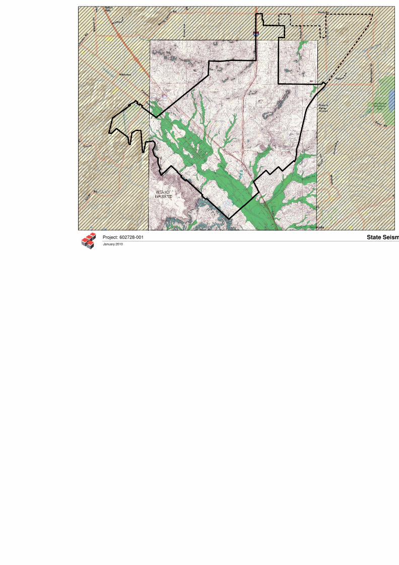
8/3/2019 G_Seismic & Geologic Hazards Existing Conditions Report
http://slidepdf.com/reader/full/gseismic-geologic-hazards-existing-conditions-report 34/54
January 2010
Project: 602728-001
8/3/2019 G_Seismic & Geologic Hazards Existing Conditions Report
http://slidepdf.com/reader/full/gseismic-geologic-hazards-existing-conditions-report 35/54
8/3/2019 G_Seismic & Geologic Hazards Existing Conditions Report
http://slidepdf.com/reader/full/gseismic-geologic-hazards-existing-conditions-report 36/54
Seismic and Geologic Hazards Review 602728-001
Ciry of Murrieta, California January 8, 2010
California Geologic Survey, (CGS), 2007a, Note 48, Checklist for the Review of Engineering
Geology and Seismology Reports for California Public Schools, Hospitals, and
Essential Services B uildings, dated October, 2007.
California Geologic Survey, (CGS), 2007b, Seismic Hazard Zone Report for the Murrieta 7.5-Minute Quadrangle, Seismic Hazard Zone Report 115.
California, Geologic Survey (CGS), 2009, http://www.conservation.ca.~ov/c~s/minerals/
hazardous minerals/radon.
California, State of, Department of Water Resources, Water Data Library, website viewed on
December 2009, http://wdl.water.ca.gov/gw/map/scal.cfrn.
CH J Incorpo rated, 2007, Geo technical I~lve stigation, Proposed Murrieta C ampus Project,
Northeast of M onroe A venue and Fig Street, Murrieta, CA , dated October 3 1.
Criscione, J.J., et al, 19 78, The age o f sedimentationldiagenesis for the Bedford Cany onFormation and the Santa Monica Formation in Southern California, a Rb/Sr
evaluation, in: Mesozoic Paleogeography of the Western United States, D.G.
Howell and K.A. McDougall, eds. Pacific Section of the S.E.P.M., Los Angeles,
California.
Gastil, G., et al, 1978, Mesozoic History of Peninsular C alifornia and Related Areas East o f the
Gulf of California, in: Me sozoic Paleogeograp hy at the Western United States, D.G.
Howell and K.A. McDougall, eds. Pacific Section of the S.E.P.M., Los Angeles,
California.
GeoSoils, Inc., 1992a, Faulting and Seismic Concerns, Proposed Murrieta Springs Mall, City of
Murrieta, Riverside County, California, W.O. 558-A-RC , dated Augu st 20, 1992.
GeoSoils, Inc., 1992b, Second Party Review, Geologic and Geotechnical Studies, for the
Proposed Murrieta Springs Mall, Murrieta, Riverside County, W.O. 558-A-RC,
dated October 30, 1992.
Geo Soils, Inc., 1993, Response to "Comm ents an d Response to Second Party Review Geological
and Geotechnical Studies for the Proposed Murrieta Springs Mall, Murrieta,
Riverside Cou nty, dated D ecember 3 1, 1997, Job No. 692 -123 by M & T Agra,
Inc., W.O. 558-A -RC, dated January 26, 1993.
Hart, E.W., and Bryant, W . A., 1997, Fault-rupture hazard zones in California, Alquist-Priolo
Earthquake Fault Zoning with Index to Earthquake Zones Maps: Department ofConservation, Division of Mines and Geology, Special Publication 42. Interim
Revision 2007.
International Conference of Building Officials (ICBO), 1998, Maps of Know n Active Fault Near- Source Zones in California and Adjacent Portions of Nevada.
8/3/2019 G_Seismic & Geologic Hazards Existing Conditions Report
http://slidepdf.com/reader/full/gseismic-geologic-hazards-existing-conditions-report 37/54
8/3/2019 G_Seismic & Geologic Hazards Existing Conditions Report
http://slidepdf.com/reader/full/gseismic-geologic-hazards-existing-conditions-report 38/54
Seismic and Geologic Hazards Review 602728-001
City of Murrieta, Califorflia January 8,201
Leighton and Associates, Inc., 1998c, As-Graded Report of Rough Grading Celebrity Theater,
Arena, and Buildings C, F and H, RogersD ale U.S.A., Murrieta, California, Project
No. 11980052-003, dated December 3, 1998.
Leighton and Associate, Inc., 199 9a, Geotechnical Investigation, Proposed Sewer Line, Interstate15, Station 26+0 0 to 3 1+00, Murrieta, California, Project No. 11980052-004, dated
June 2 1, 1999.
Leighton and Associates, Inc., 1999b, Groundwater Conditions, Greer Ranch, Murrieta Area,
Riverside County, California, P roject No. 1 1890865-003, letter dated Nove mber 1 1,
1999.
Leighton and Associates, Inc., 2002, Supplemental Geotechnical Investigation, Tentative Tract
No. 28533-1, Mapleton, Murrieta, California, Project No. 110667-003, dated April
22 ,2002 .
Leighton an d Associates, Inc., 2003, As-Graded Report of Rough-G rading for Lots 1 through 78,Tract 29640-9, Greer Ranch, City of Murrieta, California, Project No. 11890865-
022, dated September 15, 2003.
Leighton a nd Associates, Inc., 2006a, Preliminary Geotechnical Investigation Up date Report and
Supplemental Investigation, Proposed M urrieta Triangle Comm ercial Development,
Murrieta, California, Project No. 601 178-002, dated M arch 14, 2006.
Leighton and Associates, Inc. 2006b, Geotechnical Review and Preliminary Geotechnical
Investigation, Great Lands Murrieta 320, Murrieta Area, Riverside County,
California, Project No. 11 1952-0 01, dated Aug ust 3, 2006.
Leighton Consulting, Inc., 2004, Geotechnical Investigation for Proposed Riverside CountyOffice of Education, Murrieta Regional Learning Center, Murrieta, California, date
February 24 (updated April 22 ,20 08 )
Leighton Consulting, Inc., 2005, Report of Preliminary Geologic Fault Investigation, Proposed
High School No. 3 Northeast Corner of Monroe Avenue and Los Alamos Road,
City of Murrieta, Riverside County, California, project No. 600187-003, dated
September 15, 2005.
Leighton Consulting, Inc., 2006a, Updated Report of Preliminary Geologic Fault Investigation,
Proposed High School No. 3 Northeast Corner of Monroe Avenue and Los Alamos
Road, City of M urrieta, Riverside County, California, Pro-ject No. 600187-003,
dated September 1 5,2 00 5, updated April 28 ,20 06 .
Leighton Consulting, Inc., 2006b, Preliminary Geotechnical Investigation, Mui-sieta Valley
Unified School District, Proposed Murrieta High School 110. 3, Murrieta,
California, project No. 6001 87-005, dated Ju ne 30, 2006.
8/3/2019 G_Seismic & Geologic Hazards Existing Conditions Report
http://slidepdf.com/reader/full/gseismic-geologic-hazards-existing-conditions-report 39/54
Seismic and Geologic Hazards Review 602728-001
City of Murrieta, California January 8, 2010
Leighton Consulting, Inc., 2006c, Geotechnical Investigation, Murrieta Valley USD Proposed
Lisa J. Mails Elementary School, Briggs, Road, Murrieta, California, Project No.
60085 1-003, dated February 28 ,20 06.
Leighton Consulting, Inc., 2006d, Supplemental Geotechnical Investigation for The Commons atFrench Valley, Northwest Corner of Winchester Road (State Highway 79) and
Clinton Keith Road (Proposed), French Valley Area, County of Riverside,
California, Project No. 60 1 181-003, dated October 11, 2006.
Leighton Consulting, Inc., 2007, Results of Fault Trenching, Murrieta 25 - Southwest Corner of
Jefferson Avenue and F ig Street, Murrieta, California, Project No. 601 843-001,
dated May 24,200 7.
Leighton Consulting, Inc., 2008a, Preliminary Geotechnical Report, The Triangle Specific Plan,
South of Murrieta Hot Springs Road and between 1-15 and 1-215, City of Murrieta,
California, Project N o. 60 1914-002, dated January 1 1,2 006 .
Leighton Consulting, Inc., 2008b, Geotechnical Investigation, W estern Municipal Water District
(WMWD), Hayes Avenue Water Pipeline, Murrieta, California, Project No.
602428-001, dated December 22,2 00 8.
Leighton Consulting, Inc., 2009, Revised Feasibility Study for Onsite Septic System 1 Leach
Field, Temporary Fire Station No. 5, West of Vineyard Parkway, Murrieta,
California, Project No. 60 23 16-001 , dated January 28, 2009.
Mann, John F., 1955, Geology of a Portion of the Elsinore Fault Zone, California Division of
Mines and Geology, Special Report 43.
Mo ore and Ta ber, 199 2, Repo rt Geotec hnical Inv estigation, Murrieta Spring s Mall, Job IVo. 692-123, dated August 28, 1992.
Moore & Taber Agra, Inc., 1992a, Additional Geologic Studies, Murrieta Springs Mall, Job No.
692-123, dated October 5, 1992.
Moore & Taber Agra, Inc., 1992b, Comments and Response to Second Party Review Geological
and Geotechnical Studies for the Proposed Mul-rieta Springs Mall, Murrieta,
Riverside County, Job N o. 692- 123, dated Decem ber 3 1, 1992.
Murrieta, City of, 2005, Grading Manual, Department of Public Works, Resolution No. 93-206,
Adapted May 4, 1993 (Revised February 7,2 00 5).
Pacific Soils Engineering, Inc., 1992, Murrieta Special Geologic Study Zone Report, Murrieta,California, dated April 17, 1992.
Pacific Soils Engineering, Inc., 1990a, Bridge Foundation Investigation, Tenaja Road and
Murrieta Creek, Murrieta, in the County of Riverside, California, Work Order
4002 19B, dated February 15, 1990.
8/3/2019 G_Seismic & Geologic Hazards Existing Conditions Report
http://slidepdf.com/reader/full/gseismic-geologic-hazards-existing-conditions-report 40/54
Seismic and Geologic Hazards Re view 602728-001
Cily of Murrieta, California Janualy 8, 2010
Pacific So ils Engineering, Inc., 19 90b, Fault and Liquefaction Study, 520* Acre Vineyard
Project, in the County of Riverside, California, Work Order 4002 19, dated A pril 24.
Pacific S oils Engineering, Inc., 1990c, Revised Geotechnical Grading Plan Review, for Tentative
Tracts, 25713, 25260, 25284, 25288, 25300, 25368, 25381, 25383, 25392 and25394, a Portion of Specific Plan No. 215 (The Vineyard Project), in the Murrieta
Com mun ity, in the C ounty of Riverside, California, W ork Order 4002 19, dated
August 21, 1990.
Pacific S oils Engineering, Inc., 1991a, Additional Fault Trenching, School Site, Tract 25253, in
the C ounty o f Riverside, California, Wo rk O rder 4002 19, dated April 24, 199 1.
Pacific S oils Engineering, Inc., 1991b , Supp lemental Fault Investigation for the 10.4 Acre
Schoo l Site, Tract 25 153 at "The Vineyard" Project, in the Muwieta C omm unity, in
the Co unty of Riverside, California, Work Order 4002 19, dated May 8, 19 91.
Pacific So ils Engineerin g, Inc., 199 1c, Revised Geotechnical G rading Plan Review for TentativeTract 27118 a Portion of Specific Plan No. 215 (The Vineyard Project), in the
Muwieta Community, in the County of Riverside, California, Work Order 400219,
dated July 18, 199 1.
Pacific So ils Engineering, Inc., 1 992, Muwieta Special Geologic Study Zone Project Report,
Murrieta, California, dated April 1 7, 1992.
Riverside, County of, 2000, Department of Transportation and Land Management Building and
Safety Department, Technical G uidelines for Review of Geotechnical and Geologic
Reports.
Riverside, Co unty of, 2003, General Plan Safety Element and Appendix H-
Geotechnical Report(Technical Background Document), Adopted October 7, 2003.
Soil Tech, Inc., 1990, Alquist-Priolo Special Studies Zone, Tentative Parcel Map No. 23874,
County G eologic Report No. 715 , Ranch o California Area, Riverside County, dated
June 18, 1990.
Southern California Soil & Testing, Inc., 2004, Preliminary G eotechnical Investigation, M urrieta
25, Southwest Corner of Jefferson Avenue and Fig Street, Murrieta, California,
dated April 6, 2004.
Tokimatsu, K., and Seed, H.B., 1987, Evaluation of Settlements in Sands Due to Earthquake
Shaking , ASC E Journal of Geotechnical E ngineering, Vol. 1 13, No. 8, datedAugust 1987.
United States Geological Survey, (USGS), 2002. Docuinentation for the 2002, Update of the
National Seismic Hazard Maps: Open-File Report 02-420, 33p. By Frankel, A.D.,
et al.
8/3/2019 G_Seismic & Geologic Hazards Existing Conditions Report
http://slidepdf.com/reader/full/gseismic-geologic-hazards-existing-conditions-report 41/54
Seismic and Geologic Hazards Review 602728-001
City of Murrieta, California January 8, 2010
United States Geological Survey, (USGS), 2007, A Computer Program Published by USGS to
Calculate Seismic Hazard Curves and Response and Design Parameters based on
ASC E 7-05 Seismic Procedures, Version 5.0.8, Revision ed. Nov 2007.
WGCEP - Working Group on California Earthquake Probabilities, 1995, Seismic Hazards inSouthern California: Probable Earthquake Probabilities, Bull. Seismol. Soc. Amer.,
Vol. 85, No. 2, pp 379-439.
Willis, C.J., 1998, Ground Cracks in Wolf and Temecula Valleys, Riverside County, California:
California Division of Mines and G eology Fault Evaluation Report, FER-195.
Aerial Photosra~hs eviewed
Fliqht Date Source Photo qraph No. Scale
311 1/48 USA F 102A , 104A 1:11,300
8/28/53 USDA AX N - K:37-4157-60, 132, 133, 149-151 1 20,000
51916 1 RC FCD 4-7 1 12,0 00
1/28/62 RCFCD 18, 19 1 24,000
1/28/62 RCFCD 1-66, 1-67 1 :24,000
113 0162 RC FC D 3-409,:-4 10 1 :24,000
91 16/64 RCFCD 1-12, 14-2 0,38 -40 1 12,000
9130164 RCFCD 36-38,49, 50 1:12,000
1 1/23/64 RCFCD 70-72, 77-80 1 :12,000
511 6/68 RC FC D 14-16,22-25 1:12,000
6/25/68 RCFCD 1 , 2 1 24.000
2120172 RCF CD 30 -32 ,41 -4 3 1 12,000
6120174 RCF CD 726 ,728 -73 3, 803-808,
874-877,956,957 1 :24,000
1/27/78 RCFC D 43-45 1 6,000
5/4/80 RCFC D 759, 760, 833, 834,
980 ,982 ,983 1:24,0002/28/80 RCFCD 3-7 ,20 ,21 1 :6,000
12/8/83 RCFC D 360-36 2,393-39 9 1 19,200
1211 5/83 RCFC D 555-558, 587-589 1 :19,200
1/25/90 RCFCD 15-90, 15-20 1 19,800

8/3/2019 G_Seismic & Geologic Hazards Existing Conditions Report
http://slidepdf.com/reader/full/gseismic-geologic-hazards-existing-conditions-report 42/54
Seismic and Geologic Hazards Review 602728-001
City of Murrieta/ California January 8,201 0
A P P E N D I X B
GENERAL SPEC:[FICATIONS FOR RO UGH GRA DING
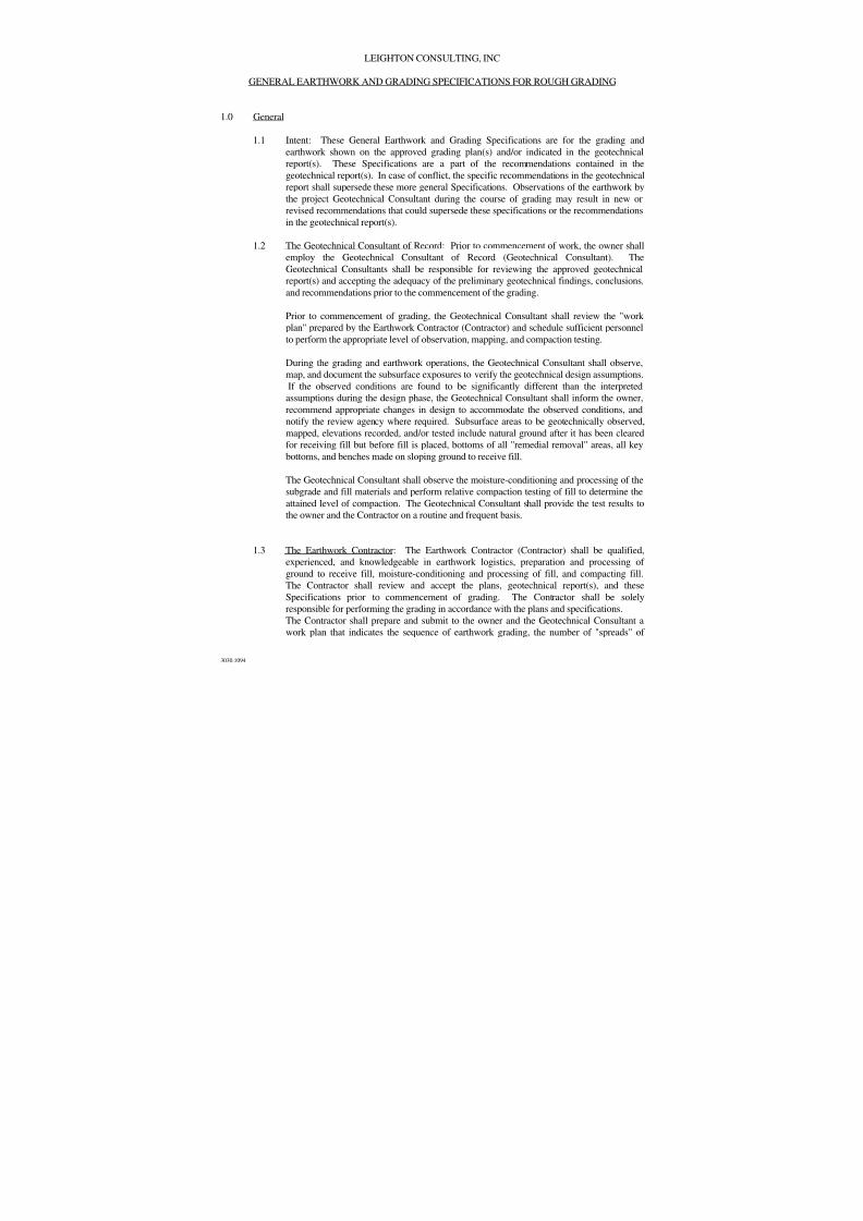
8/3/2019 G_Seismic & Geologic Hazards Existing Conditions Report
http://slidepdf.com/reader/full/gseismic-geologic-hazards-existing-conditions-report 43/54
3030.1094
LEIGHTON CONSULTING, INC
GENERAL EARTHWORK AND GRADING SPECIFICATIONS FOR ROUGH GRADING
1.0 General
1.1 Intent: These General Earthwork and Grading Specifications are for the grading andearthwork shown on the approved grading plan(s) and/or indicated in the geotechnical
report(s). These Specifications are a part of the recommendations contained in the
geotechnical report(s). In case of conflict, the specific recommendations in the geotechnical
report shall supersede these more general Specifications. Observations of the earthwork by
the project Geotechnical Consultant during the course of grading may result in new or
revised recommendations that could supersede these specifications or the recommendations
in the geotechnical report(s).
1.2 The Geotechnical Consultant of Record: Prior to commencement of work, the owner shall
employ the Geotechnical Consultant of Record (Geotechnical Consultant). The
Geotechnical Consultants shall be responsible for reviewing the approved geotechnical
report(s) and accepting the adequacy of the preliminary geotechnical findings, conclusions,
and recommendations prior to the commencement of the grading.
Prior to commencement of grading, the Geotechnical Consultant shall review the "work
plan" prepared by the Earthwork Contractor (Contractor) and schedule sufficient personnel
to perform the appropriate level of observation, mapping, and compaction testing.
During the grading and earthwork operations, the Geotechnical Consultant shall observe,
map, and document the subsurface exposures to verify the geotechnical design assumptions.
If the observed conditions are found to be significantly different than the interpreted
assumptions during the design phase, the Geotechnical Consultant shall inform the owner,
recommend appropriate changes in design to accommodate the observed conditions, andnotify the review agency where required. Subsurface areas to be geotechnically observed,
mapped, elevations recorded, and/or tested include natural ground after it has been cleared
for receiving fill but before fill is placed, bottoms of all "remedial removal" areas, all key
bottoms, and benches made on sloping ground to receive fill.
The Geotechnical Consultant shall observe the moisture-conditioning and processing of the
subgrade and fill materials and perform relative compaction testing of fill to determine the
attained level of compaction. The Geotechnical Consultant shall provide the test results to
the owner and the Contractor on a routine and frequent basis.
1.3 The Earthwork Contractor: The Earthwork Contractor (Contractor) shall be qualified,experienced, and knowledgeable in earthwork logistics, preparation and processing of
ground to receive fill, moisture-conditioning and processing of fill, and compacting fill.
The Contractor shall review and accept the plans, geotechnical report(s), and these
Specifications prior to commencement of grading. The Contractor shall be solely
responsible for performing the grading in accordance with the plans and specifications.
The Contractor shall prepare and submit to the owner and the Geotechnical Consultant a
work plan that indicates the sequence of earthwork grading, the number of "spreads" of
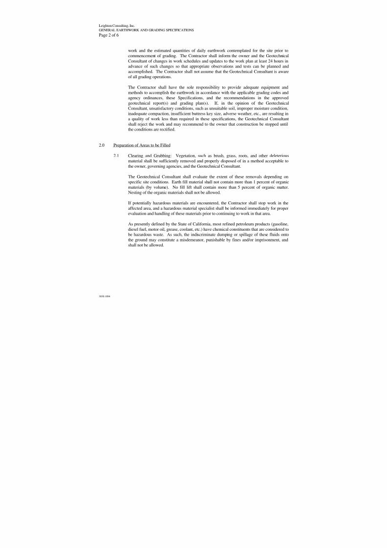
8/3/2019 G_Seismic & Geologic Hazards Existing Conditions Report
http://slidepdf.com/reader/full/gseismic-geologic-hazards-existing-conditions-report 44/54
Leighton Consulting, Inc.
GENERAL EARTHWORK AND GRADING SPECIFICATIONS
Page 2 of 6
3030.1094
work and the estimated quantities of daily earthwork contemplated for the site prior to
commencement of grading. The Contractor shall inform the owner and the Geotechnical
Consultant of changes in work schedules and updates to the work plan at least 24 hours inadvance of such changes so that appropriate observations and tests can be planned and
accomplished. The Contractor shall not assume that the Geotechnical Consultant is aware
of all grading operations.
The Contractor shall have the sole responsibility to provide adequate equipment and
methods to accomplish the earthwork in accordance with the applicable grading codes and
agency ordinances, these Specifications, and the recommendations in the approved
geotechnical report(s) and grading plan(s). If, in the opinion of the Geotechnical
Consultant, unsatisfactory conditions, such as unsuitable soil, improper moisture condition,
inadequate compaction, insufficient buttress key size, adverse weather, etc., are resulting in
a quality of work less than required in these specifications, the Geotechnical Consultant
shall reject the work and may recommend to the owner that construction be stopped untilthe conditions are rectified.
2.0 Preparation of Areas to be Filled
2.1 Clearing and Grubbing: Vegetation, such as brush, grass, roots, and other deleterious
material shall be sufficiently removed and properly disposed of in a method acceptable to
the owner, governing agencies, and the Geotechnical Consultant.
The Geotechnical Consultant shall evaluate the extent of these removals depending on
specific site conditions. Earth fill material shall not contain more than 1 percent of organic
materials (by volume). No fill lift shall contain more than 5 percent of organic matter.Nesting of the organic materials shall not be allowed.
If potentially hazardous materials are encountered, the Contractor shall stop work in the
affected area, and a hazardous material specialist shall be informed immediately for proper
evaluation and handling of these materials prior to continuing to work in that area.
As presently defined by the State of California, most refined petroleum products (gasoline,
diesel fuel, motor oil, grease, coolant, etc.) have chemical constituents that are considered to
be hazardous waste. As such, the indiscriminate dumping or spillage of these fluids onto
the ground may constitute a misdemeanor, punishable by fines and/or imprisonment, and
shall not be allowed.
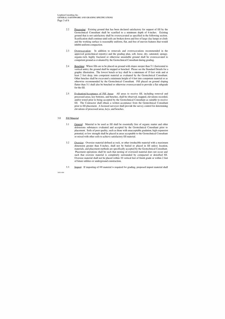
8/3/2019 G_Seismic & Geologic Hazards Existing Conditions Report
http://slidepdf.com/reader/full/gseismic-geologic-hazards-existing-conditions-report 45/54
Leighton Consulting, Inc.
GENERAL EARTHWORK AND GRADING SPECIFICATIONS
Page 3 of 6
3030.1094
2.2 Processing: Existing ground that has been declared satisfactory for support of fill by the
Geotechnical Consultant shall be scarified to a minimum depth of 6 inches. Existing
ground that is not satisfactory shall be overexcavated as specified in the following section.Scarification shall continue until soils are broken down and free of large clay lumps or clods
and the working surface is reasonably uniform, flat, and free of uneven features that would
inhibit uniform compaction.
2.3 Overexcavation: In addition to removals and overexcavations recommended in the
approved geotechnical report(s) and the grading plan, soft, loose, dry, saturated, spongy,
organic-rich, highly fractured or otherwise unsuitable ground shall be overexcavated to
competent ground as evaluated by the Geotechnical Consultant during grading.
2.4 Benching: Where fills are to be placed on ground with slopes steeper than 5:1 (horizontal to
vertical units), the ground shall be stepped or benched. Please see the Standard Details for a
graphic illustration. The lowest bench or key shall be a minimum of 15 feet wide and atleast 2 feet deep, into competent material as evaluated by the Geotechnical Consultant.
Other benches shall be excavated a minimum height of 4 feet into competent material or as
otherwise recommended by the Geotechnical Consultant. Fill placed on ground sloping
flatter than 5:1 shall also be benched or otherwise overexcavated to provide a flat subgrade
for the fill.
2.5 Evaluation/Acceptance of Fill Areas: All areas to receive fill, including removal and
processed areas, key bottoms, and benches, shall be observed, mapped, elevations recorded,
and/or tested prior to being accepted by the Geotechnical Consultant as suitable to receive
fill. The Contractor shall obtain a written acceptance from the Geotechnical Consultant
prior to fill placement. A licensed surveyor shall provide the survey control for determining
elevations of processed areas, keys, and benches.
3.0 Fill Material
3.1 General: Material to be used as fill shall be essentially free of organic matter and other
deleterious substances evaluated and accepted by the Geotechnical Consultant prior to
placement. Soils of poor quality, such as those with unacceptable gradation, high expansion
potential, or low strength shall be placed in areas acceptable to the Geotechnical Consultant
or mixed with other soils to achieve satisfactory fill material.
3.2 Oversize: Oversize material defined as rock, or other irreducible material with a maximum
dimension greater than 8 inches, shall not be buried or placed in fill unless location,
materials, and placement methods are specifically accepted by the Geotechnical Consultant.
Placement operations shall be such that nesting of oversized material does not occur and
such that oversize material is completely surrounded by compacted or densified fill.
Oversize material shall not be placed within 10 vertical feet of finish grade or within 2 feet
of future utilities or underground construction.
3.3 Import: If importing of fill material is required for grading, proposed import material shall
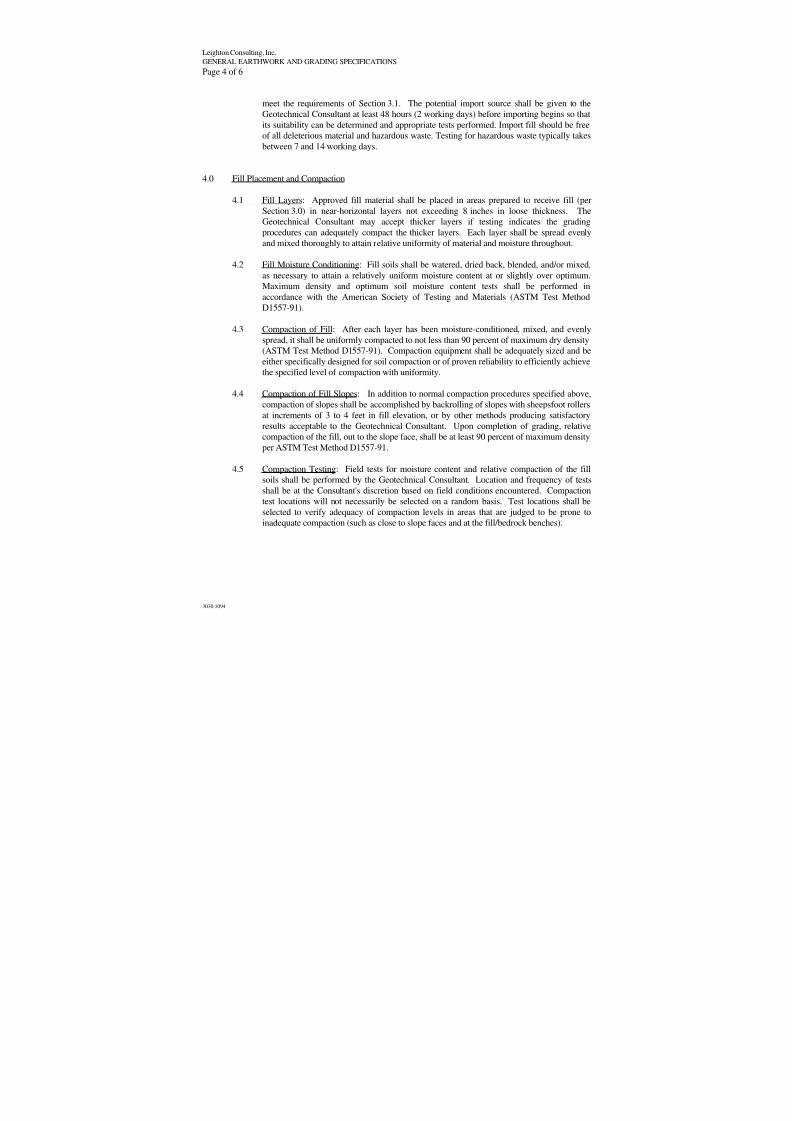
8/3/2019 G_Seismic & Geologic Hazards Existing Conditions Report
http://slidepdf.com/reader/full/gseismic-geologic-hazards-existing-conditions-report 46/54
Leighton Consulting, Inc.
GENERAL EARTHWORK AND GRADING SPECIFICATIONS
Page 4 of 6
3030.1094
meet the requirements of Section 3.1. The potential import source shall be given to the
Geotechnical Consultant at least 48 hours (2 working days) before importing begins so that
its suitability can be determined and appropriate tests performed. Import fill should be freeof all deleterious material and hazardous waste. Testing for hazardous waste typically takes
between 7 and 14 working days.
4.0 Fill Placement and Compaction
4.1 Fill Layers: Approved fill material shall be placed in areas prepared to receive fill (per
Section 3.0) in near-horizontal layers not exceeding 8 inches in loose thickness. The
Geotechnical Consultant may accept thicker layers if testing indicates the grading
procedures can adequately compact the thicker layers. Each layer shall be spread evenly
and mixed thoroughly to attain relative uniformity of material and moisture throughout.
4.2 Fill Moisture Conditioning: Fill soils shall be watered, dried back, blended, and/or mixed,
as necessary to attain a relatively uniform moisture content at or slightly over optimum.
Maximum density and optimum soil moisture content tests shall be performed in
accordance with the American Society of Testing and Materials (ASTM Test Method
D1557-91).
4.3 Compaction of Fill: After each layer has been moisture-conditioned, mixed, and evenly
spread, it shall be uniformly compacted to not less than 90 percent of maximum dry density
(ASTM Test Method D1557-91). Compaction equipment shall be adequately sized and be
either specifically designed for soil compaction or of proven reliability to efficiently achieve
the specified level of compaction with uniformity.
4.4 Compaction of Fill Slopes: In addition to normal compaction procedures specified above,
compaction of slopes shall be accomplished by backrolling of slopes with sheepsfoot rollers
at increments of 3 to 4 feet in fill elevation, or by other methods producing satisfactory
results acceptable to the Geotechnical Consultant. Upon completion of grading, relative
compaction of the fill, out to the slope face, shall be at least 90 percent of maximum density
per ASTM Test Method D1557-91.
4.5 Compaction Testing: Field tests for moisture content and relative compaction of the fill
soils shall be performed by the Geotechnical Consultant. Location and frequency of tests
shall be at the Consultant's discretion based on field conditions encountered. Compaction
test locations will not necessarily be selected on a random basis. Test locations shall be
selected to verify adequacy of compaction levels in areas that are judged to be prone to
inadequate compaction (such as close to slope faces and at the fill/bedrock benches).
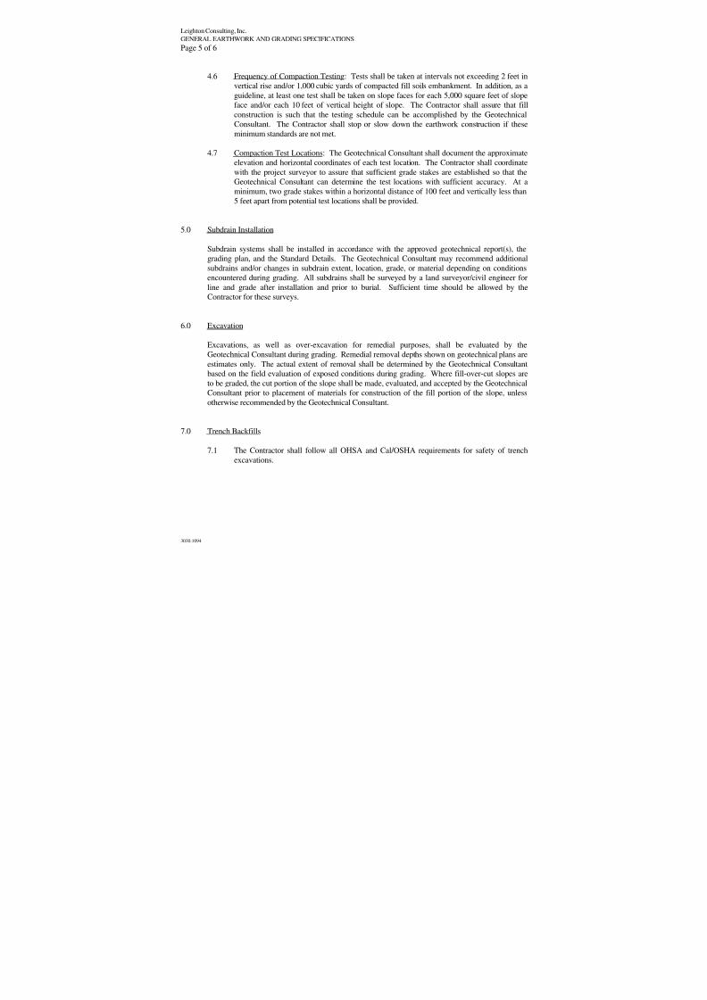
8/3/2019 G_Seismic & Geologic Hazards Existing Conditions Report
http://slidepdf.com/reader/full/gseismic-geologic-hazards-existing-conditions-report 47/54
Leighton Consulting, Inc.
GENERAL EARTHWORK AND GRADING SPECIFICATIONS
Page 5 of 6
3030.1094
4.6 Frequency of Compaction Testing: Tests shall be taken at intervals not exceeding 2 feet in
vertical rise and/or 1,000 cubic yards of compacted fill soils embankment. In addition, as a
guideline, at least one test shall be taken on slope faces for each 5,000 square feet of slope
face and/or each 10 feet of vertical height of slope. The Contractor shall assure that fill
construction is such that the testing schedule can be accomplished by the GeotechnicalConsultant. The Contractor shall stop or slow down the earthwork construction if these
minimum standards are not met.
4.7 Compaction Test Locations: The Geotechnical Consultant shall document the approximate
elevation and horizontal coordinates of each test location. The Contractor shall coordinate
with the project surveyor to assure that sufficient grade stakes are established so that the
Geotechnical Consultant can determine the test locations with sufficient accuracy. At a
minimum, two grade stakes within a horizontal distance of 100 feet and vertically less than
5 feet apart from potential test locations shall be provided.
5.0 Subdrain Installation
Subdrain systems shall be installed in accordance with the approved geotechnical report(s), the
grading plan, and the Standard Details. The Geotechnical Consultant may recommend additional
subdrains and/or changes in subdrain extent, location, grade, or material depending on conditions
encountered during grading. All subdrains shall be surveyed by a land surveyor/civil engineer for
line and grade after installation and prior to burial. Sufficient time should be allowed by the
Contractor for these surveys.
6.0 Excavation
Excavations, as well as over-excavation for remedial purposes, shall be evaluated by the
Geotechnical Consultant during grading. Remedial removal depths shown on geotechnical plans are
estimates only. The actual extent of removal shall be determined by the Geotechnical Consultant
based on the field evaluation of exposed conditions during grading. Where fill-over-cut slopes are
to be graded, the cut portion of the slope shall be made, evaluated, and accepted by the Geotechnical
Consultant prior to placement of materials for construction of the fill portion of the slope, unless
otherwise recommended by the Geotechnical Consultant.
7.0 Trench Backfills
7.1 The Contractor shall follow all OHSA and Cal/OSHA requirements for safety of trenchexcavations.
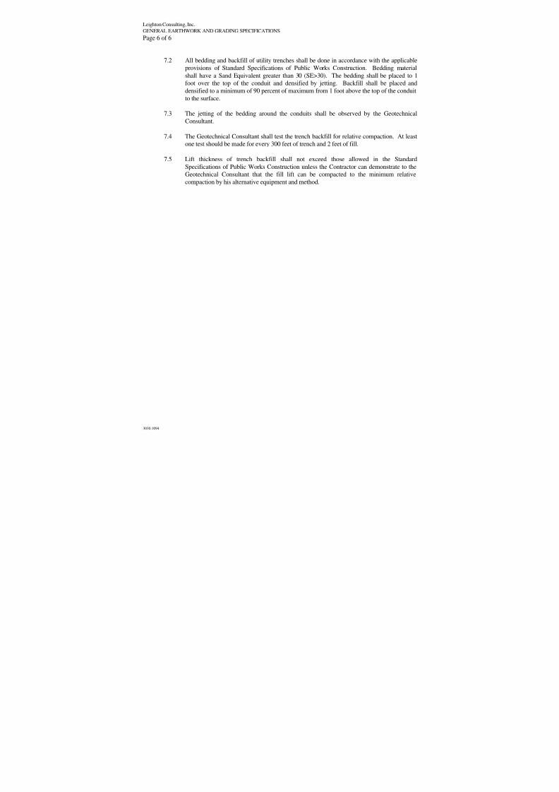
8/3/2019 G_Seismic & Geologic Hazards Existing Conditions Report
http://slidepdf.com/reader/full/gseismic-geologic-hazards-existing-conditions-report 48/54
Leighton Consulting, Inc.
GENERAL EARTHWORK AND GRADING SPECIFICATIONS
Page 6 of 6
3030.1094
7.2 All bedding and backfill of utility trenches shall be done in accordance with the applicable
provisions of Standard Specifications of Public Works Construction. Bedding material
shall have a Sand Equivalent greater than 30 (SE>30). The bedding shall be placed to 1
foot over the top of the conduit and densified by jetting. Backfill shall be placed and
densified to a minimum of 90 percent of maximum from 1 foot above the top of the conduitto the surface.
7.3 The jetting of the bedding around the conduits shall be observed by the Geotechnical
Consultant.
7.4 The Geotechnical Consultant shall test the trench backfill for relative compaction. At least
one test should be made for every 300 feet of trench and 2 feet of fill.
7.5 Lift thickness of trench backfill shall not exceed those allowed in the Standard
Specifications of Public Works Construction unless the Contractor can demonstrate to the
Geotechnical Consultant that the fill lift can be compacted to the minimum relative
compaction by his alternative equipment and method.
8/3/2019 G_Seismic & Geologic Hazards Existing Conditions Report
http://slidepdf.com/reader/full/gseismic-geologic-hazards-existing-conditions-report 49/54
8/3/2019 G_Seismic & Geologic Hazards Existing Conditions Report
http://slidepdf.com/reader/full/gseismic-geologic-hazards-existing-conditions-report 50/54
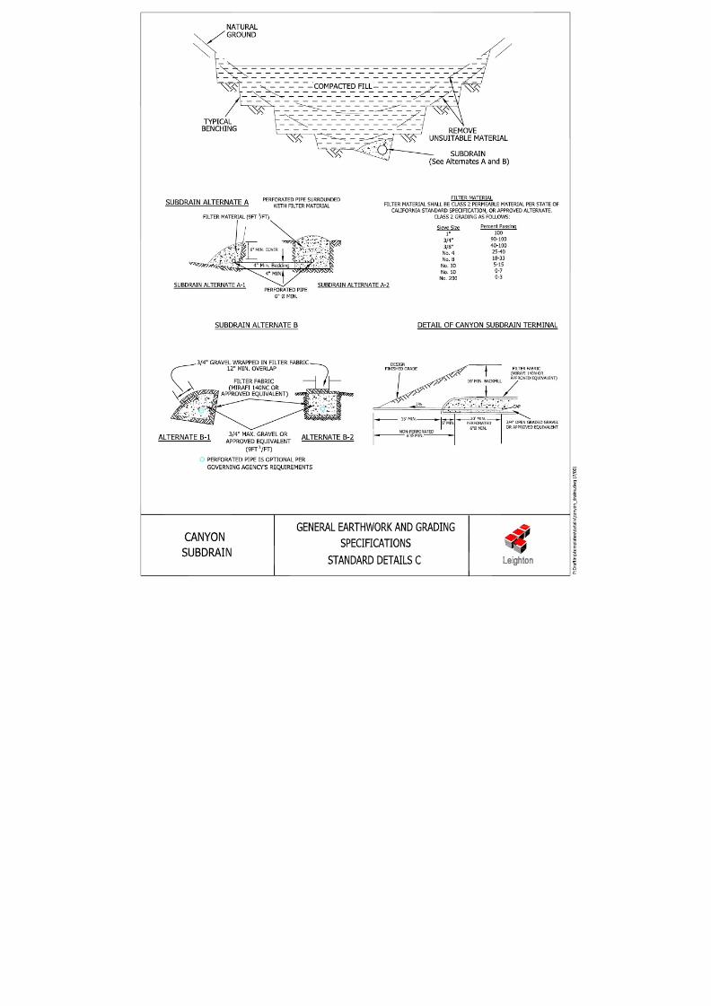
8/3/2019 G_Seismic & Geologic Hazards Existing Conditions Report
http://slidepdf.com/reader/full/gseismic-geologic-hazards-existing-conditions-report 51/54
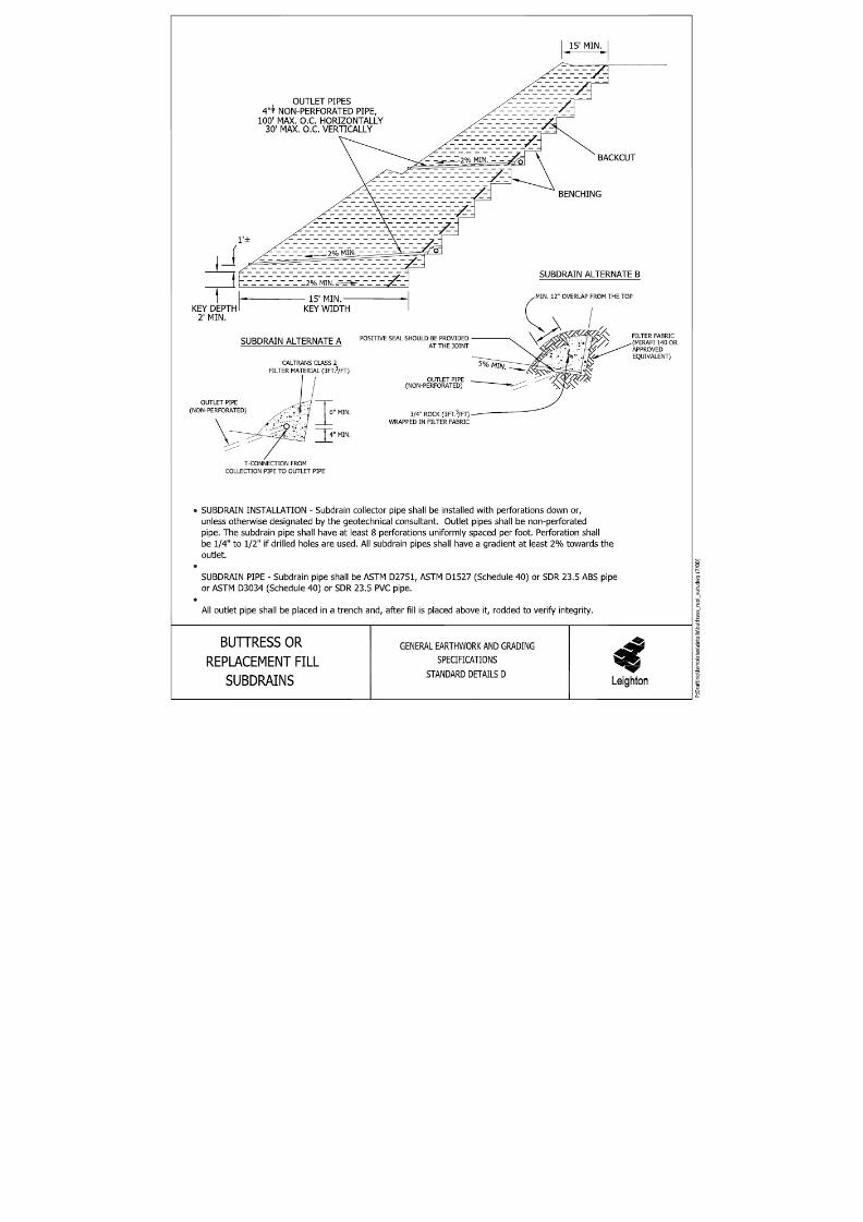
8/3/2019 G_Seismic & Geologic Hazards Existing Conditions Report
http://slidepdf.com/reader/full/gseismic-geologic-hazards-existing-conditions-report 52/54
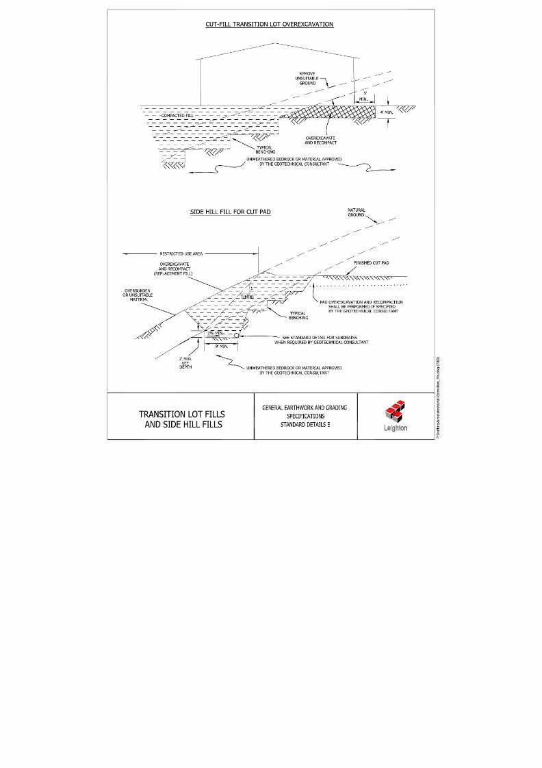
8/3/2019 G_Seismic & Geologic Hazards Existing Conditions Report
http://slidepdf.com/reader/full/gseismic-geologic-hazards-existing-conditions-report 53/54
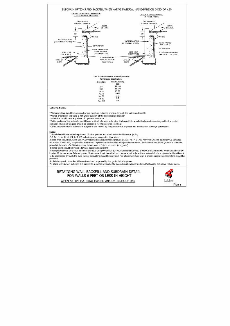
8/3/2019 G_Seismic & Geologic Hazards Existing Conditions Report
http://slidepdf.com/reader/full/gseismic-geologic-hazards-existing-conditions-report 54/54